
Flood Adaptation Measures Applicable in the Design of Urban Public Spaces: Proposal for a Conceptual Framework


Abstract
:1. Introduction
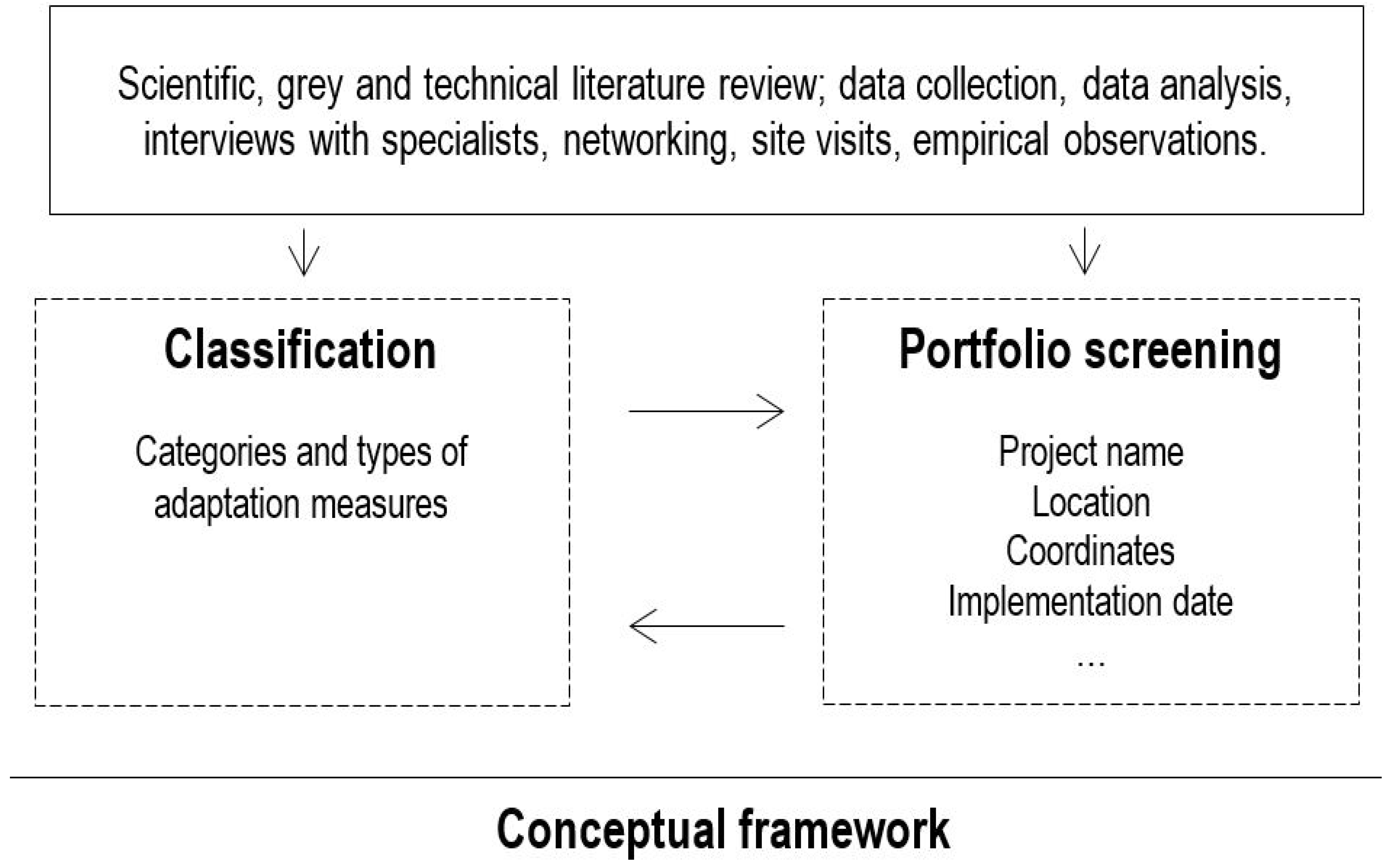
2. Methodology
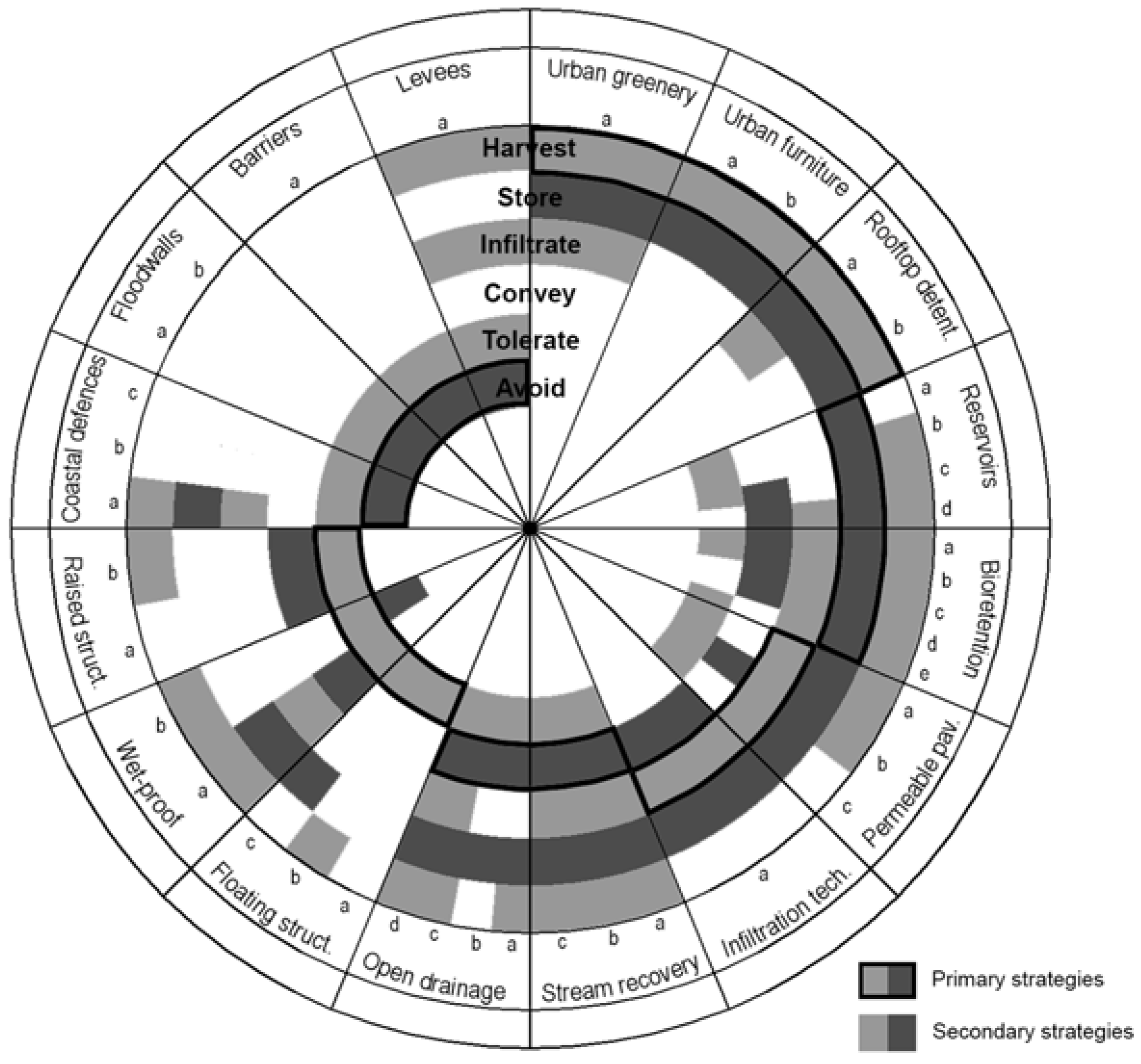
3. Results: Proposed Conceptual Framework
3.1. Assessment by Flood Adaptation Infrastructural Strategies
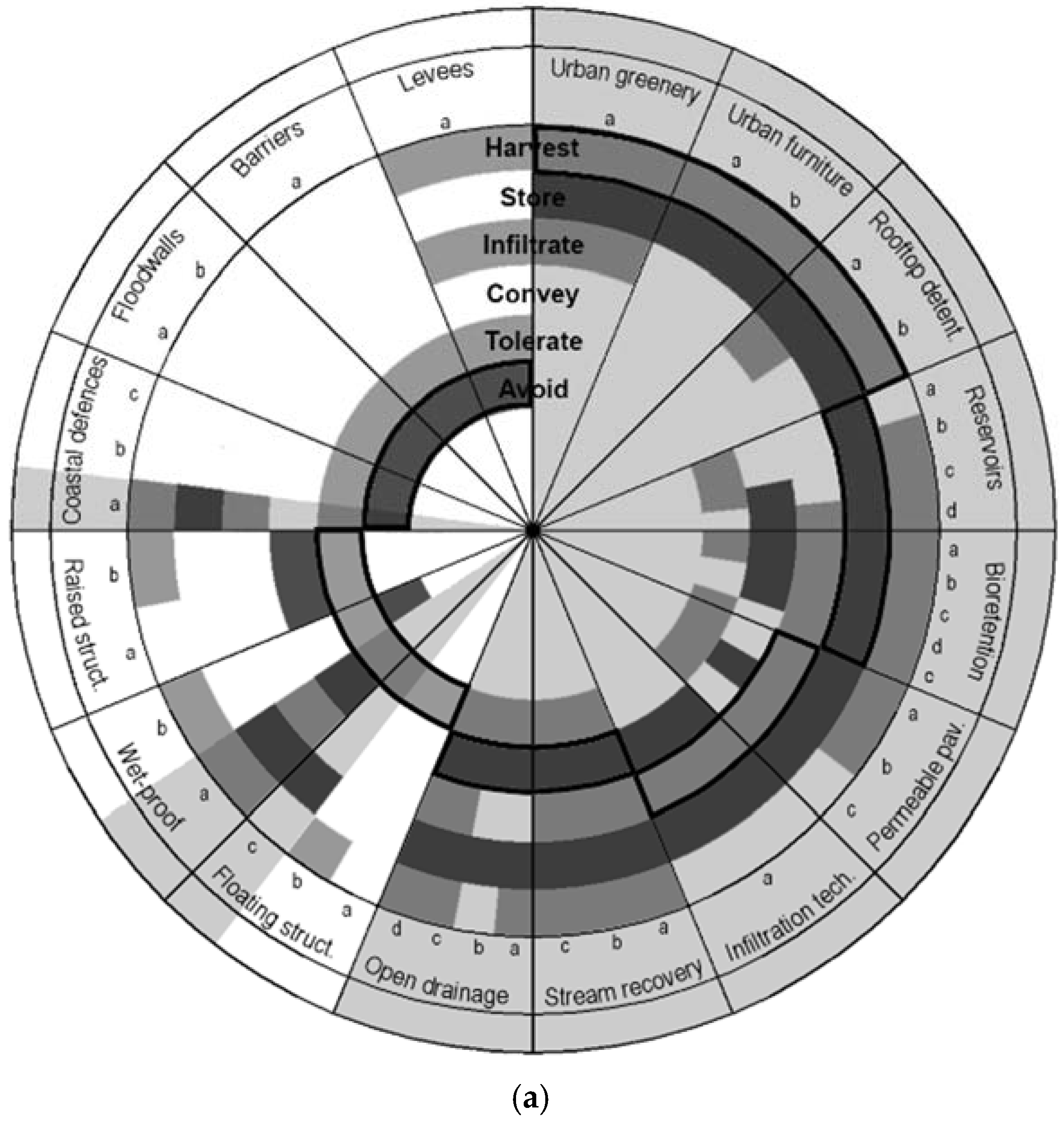
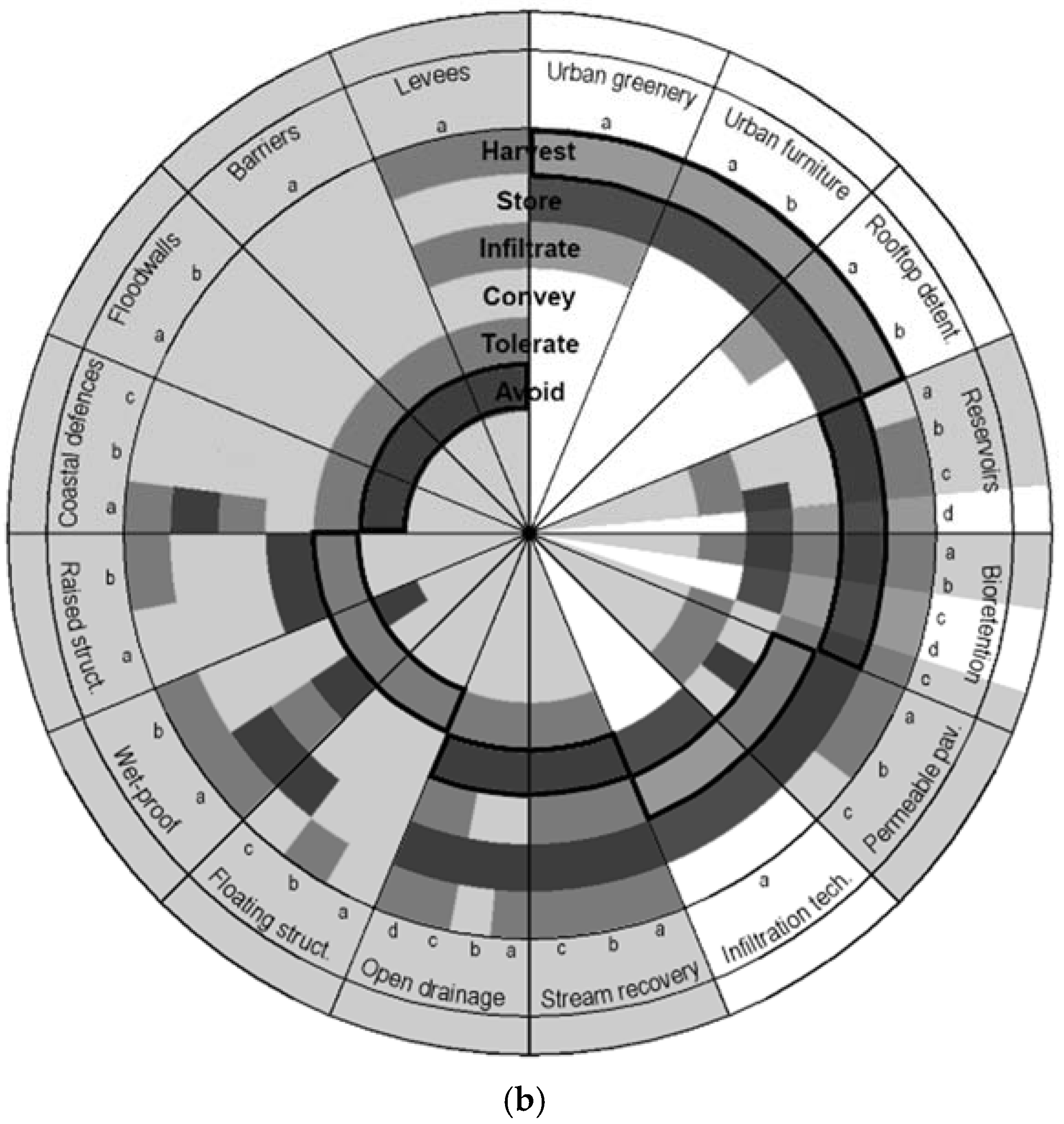
3.2. The Doughnut Diagram: Assimilating Comprehension, Simplicity and Flexibility
4. Discussion
5. Conclusions
Acknowledgments
Author Contributions
Conflicts of Interest
Abbreviations and Acronyms
References
- Intergovernmental Panel on Climate Change. Managing the Risks of Extreme Events and Disasters to Advance Climate Change Adaptation; Cambridge University Press: Cambridge, UK; New York, NY, USA, 2012. [Google Scholar]
- Coumou, D.; Rahmstorf, S. A decade of weather extremes. Nat. Clim. Chang. 2012, 2, 491–496. [Google Scholar] [CrossRef]
- Van de Ven, F.H.M.; Gersonius, B.; de Graaf, R.; Luijendijk, E.; Zevenbergen, C. Creating water robust urban environments in the netherlands: Linking spatial planning, design and asset management using a three-step approach. J. Flood Risk Manag. 2011, 4, 273–280. [Google Scholar]
- Costa, J.P.; Sousa, J.F.D.; Silva, M.M.; Nouri, A. Climate change adaptation and urbanism: A developing agenda for lisbon within the twenty-first century. Urban Des. Int. 2014, 19, 77–91. [Google Scholar] [CrossRef]
- Costa, J.P. Urbanismo e Adaptação às Alterações Climáticas, as Frentes de Água; Livros Horizonte: Lisboa, Portugal, 2013. [Google Scholar]
- Ricart, N.; Remesar, A. Reflexiones sobre el espacio publico. Waterfront 2013, 25, 5–35. [Google Scholar]
- Martin, L. The grid as generator. In Urban Design Reader; Carmona, M., Tiesdell, S., Eds.; Architectural Press: Oxford, UK, 2007; pp. 70–82. [Google Scholar]
- Portas, N. Espaço público e a cidade emergente-os novos desafios. In Design de Espaço Público: Deslocação e Proximidade; Brandão, P., Remesar, A., Eds.; Centro Português de Design: Lisboa, Portugal, 2003; pp. 16–19. [Google Scholar]
- Madanipour, A. Ambiguities of urban design. Town Plan. Rev. 1997, 68, 363–383. [Google Scholar] [CrossRef]
- Brandão, P. Ética e Profissões, no Design Urbano. Convicção, Responsabilidade e Interdisciplinaridade. Traços da Identidade Profissional no Desenho da Cidade; Tese de Doctorado de Espacio Público e Regeneración Urbana, Arte y Sociedad, Universitat de Barcelona: Barcelona, Spain, 2004. [Google Scholar]
- Arendt, H. The Human Condition, 2nd ed.; University of Chicago Press: Chicago, IL, USA, 1998; Original work published 1958. [Google Scholar]
- Pelling, M. What determines vulnerability to floods: A case study in georgetown, Guyana. Environ. Urban. 1997, 9, 203–226. [Google Scholar] [CrossRef]
- Ruddell, D.; Harlan, S.; Grossman-Clarke, S.; Chowell, G. Scales of perception: Public awareness of regional and neighborhood climates. Clim. Chang. 2012, 111, 581–607. [Google Scholar] [CrossRef]
- PPS (Project for Public Spaces). What Makes a Successful Place? Available online: http://www.pps.org/reference/grplacefeat/ (accessed on 27 June 2013).
- Jacobs, J. The Death and Life of Great American Cities; Random House: New York, NY, USA, 1992. [Google Scholar]
- Commission for Architecture and the Built Environment. Public Space Lessons—Adapting Public Space to Climate Change; CABE Space: London, UK, 2008. [Google Scholar]
- Matos Silva, M. Landscape: A Place of Cultivation. In Urban Adaptation through Flood Risk Management Infrastructure and Public Space Design; Silva, I.M.D., Marques, T.P., Andrade, G., Eds.; School of Sciences, University of Porto: Porto, Portugal, 2014; pp. 292–296. [Google Scholar]
- Matos Silva, M.; Costa, J.P. Climate change and urbanism. A new role for public space design? In The Art of Urban Design in Urban Regeneration. Interdisciplinarity, Policies, Governance, Public Space; Remesar, A., Ed.; Publicacions I Edicions de la Universitat de Barcelona: Barcelona, Spain, 2016; pp. 62–86. [Google Scholar]
- European Union. Flood risk management; flood prevention, protection and mitigation. In COM(2004)472 Final; Commission of the European Communities: Brussels, Belgium, 2004; p. 11. [Google Scholar]
- Fletcher, T.D.; Shuster, W.; Hunt, W.F.; Ashley, R.; Butler, D.; Arthur, S.; Trowsdale, S.; Barraud, S.; Semadeni-Davies, A.; Bertrand-Krajewski, J.L.; et al. Suds, lid, bmps, wsud and more—The evolution and application of terminology surrounding urban drainage. Urban Water J. 2015, 12, 525–542. [Google Scholar] [CrossRef]
- Matos Silva, M.; Nouri, A. Adaptation measures on riverfronts, an overview of the concepts. In Climate Change Adaptation in Urbanised Estuaries Contributes to the Lisbon Case; Costa, J.P., Sousa, J.F.D., Eds.; Várzea da Rainha Impressores: Óbidos, Portugal, 2014; pp. 131–150. [Google Scholar]
- Adaptation Planning, Research and Practice. About Weadapt. Available online: http://weadapt.org/knowledge-base/guidance/overview-of-weadapt (accessed on 4 June 2011).
- United Kingdom Climate Impacts Programme. About Us. Available online: http://www.ukcip.org.uk/about-ukcip/ (accessed on 28 June 2012).
- Climate Adaptation Knowledge Exchange. About Cake. Available online: http://www.cakex.org/about-cake (accessed on 5 June 2010).
- European Climate Adaptation Platform. About Us. Available online: http://climate-adapt.eea.europa.eu/about (accessed on 28 June 2012).
- Climate ‘changes’ Spatial Planning. Climate ’Changes’ Spatial Planning Programme. Available online: http://www.climatechangesspatialplanning.nl/ (accessed on 2 June 2004).
- Adaptation and Mitigation: An Integrated Climate Policy Approach. Matrix of Adaptation Measures. Available online: http://www.amica-climate.net/online_tool.html (accessed on 4 June 2006).
- ADaptation and Mitigation Strategies: Supporting European Climate Policy. Adam Digital Compendium—Home. Available online: http://adam-digital-compendium.pik-potsdam.de/ (accessed on 6 July 2009).
- Green and Blue Space Adaptation for Urban Areas and Eco Towns. Green and Blue Space Adaptation for Urban Areas and Eco Towns. Available online: http://www.ppgis.manchester.ac.uk/grabs/ (accessed on 10 July 2008).
- ci:grasp. The Climate Impacts: Global and Regional Adaptation Support Platform. Available online: http://pik-potsdam.de/cigrasp-2/ (accessed on 1 July 2008).
- European Spatial Planning: Adapting to Climate Events. Available online: http://www.espace-project.org/ (accessed on 3 June 2007).
- Hecq, W.; Giron, E.; Sacre, D.; Coninx, I.; Bachus, K.; Dewals, B.; Detrembleur, S.; Pirotton, M.; Kahloun, M.E.; Meire, P.; et al. Adapt—Towards an Integrated Decision Tool for Adaptation Measures. Case Study: Floods; Final Report (phase 1); Belgian Science Policy: Bruxelles, Belgium, 2008; p. 129. [Google Scholar]
- Managing Water for the City of the Future. Available online: http://www.switchurbanwater.eu (accessed on 4 June 2006).
- ClimWatAdapt. Why This Project? Available online: http://www.climwatadapt.eu/ (accessed on 1 July 2010).
- Foresight. Home. Available online: http://www.bis.gov.uk/foresight (accessed on 3 June 2012).
- European Environment Agency. Urban Adaptation to Climate Change in Europe: Challenges and Opportunities for Cities Together with Supportive National and European Policies; Report No. 2/2012; European Environment Agency: Copenhagen, Denmark, 2012.
- European Environment Agency. Green Infrastructure and Territorial Cohesion: The Concept of Green Infrastructure and Its Integration into Policies Using Monitoring Systems; Report No. 18/2011; European Environment Agency, Publications Office of the European Union: Luxembourg, 2011. [Google Scholar]
- Report on Good Practice Measures for Climate Change Adaptation in River Basin Management Plans. Available online: www.icm.eionet.europa.eu (accessed on 14 May 2011).
- Town and Country Planning Association. Climate Change Adaptation by Design: A Guide for Sustainable Communities; TCPA: London, UK, 2001. [Google Scholar]
- Climate Impact Research & Response Coordination for a Larger Europe. Adaptation Inspiration Book—22 Implemented Cases of Local Climate Change Adaptation to Inspire European Citizens; Drukkerij Tienkamp: Groningen, The Netherlands, 2013. [Google Scholar]
- Prominski, M.; Stokman, A.; Zeller, S.; Voermanek, D.S.A. River. Space. Design.: Planning Strategies, Methods and Projects for Urban Rivers; Birkhauser: Berlin, Switzerland, 2012. [Google Scholar]
- Strijkers, D. Toolbox Adaptive Measures; Policopied Document by Doepel Strijkers Architects: Rotterdam, The Netherlands, 2011. [Google Scholar]
- Hoyer, J.; Dickhaut, W.; Kronawitter, L.; Weber, B. Water Sensitive Urban Design. Principles and Inspiration for Sustainable Stormwater Management in the City of the Future. Manual; Deliverable 5.1.5; HafenCity Universität: Hamburg, Germany, 2011. [Google Scholar]
- Ahern, J. From fail-safe to safe-to-fail: Sustainability and resilience in the new urban world. Landsc. Urban Plan. 2011, 100, 341–343. [Google Scholar] [CrossRef]
- Nouri, A.S. A framework of thermal sensitive urban design benchmarks: Potentiating the longevity of auckland’s public realm. Buildings 2015, 5, 252. [Google Scholar] [CrossRef]
- Howe, C.A.; Butterworth, J.; Smout, I.K.; Duffy, A.M.; Vairavamoorthy, K. Sustainable Water Management in the City of the Future: Findings from the SWITCH Project 2006–2011; UNESCO-IHE: Katwijk, The Netherlands, 2011. [Google Scholar]
- Coombes, P.J.; Barry, M.E. The effect of selection of time steps and average assumptions on the continuous simulation of rainwater cd harvesting strategies. Water Sci. Technol. 2007, 55, 125–133. [Google Scholar] [CrossRef] [PubMed]
- Coombes, P.J.; Barry, M. A systems framework of big data for analysis of policy and strategy. In Proceedings of the WSUD & IECA—H2Olistic Integration: Concept Design, Construction and Operation, Sydney, Australia, 19–20 October 2015.
- European Environment Agency (EEA). Towards Efficient Use of Water Resources in Europe; Report No. 1/2012; EEA: Copenhagen, Denmark, 2012.
- Coombes, P.J.; Argue, J.R.; Kuczera, G. Figtree place: A case study in water sensitive urban development (wsud). Urban Water 1999, 1, 335–343. [Google Scholar] [CrossRef]
- De Urbanisten. Water Square Benthemplein. Available online: http://www.urbanisten.nl (accessed on 31 May 2013).
- Philip, R. Switch Training Kit—Integrated Urban Water Management in the City of the Future; ICLEI European Secretariat GmbH|Gino Van Begin: Freiburg, Germany, 2011. [Google Scholar]
- Woods-Ballard, B.; Kellagher, R.; Martin, P.; Jefferies, C.; Bray, R.; Shaffer, P. The Suds Manual; CIRIA: London, UK, 2007. [Google Scholar]
- Robinson, A.; Hopton, H.M. Case Study of Elmer Avenue Neighborhood Retrofit. Landscape Performance Seriesp; Landscape Architecture Foundation. Available online: http://landscapeperformance.org/ (accessed on 12 January 2016).
- Kwon, K.-W. Cheong Gye Cheon Restoration Project, a Revolution in Seoul; Seoul Metropolitan Government: Seoul, Korea, 2007.
- Turenscape. Available online: http://www.turenscape.com/ (accessed on 1 June 2016).
- Valera, S. La percepció del risc. In Com "Sentim" el Risc, Observatori del Risc, Informe 2001th ed.; Mir, N., Ed.; Beta Editorial: Barcelona, Spain, 2001; pp. 235–261. [Google Scholar]
- Flood Control International. Glass Barriers—Data Sheet. Available online: http://www.floodcontrolinternational.com (accessed on 14 May 2015).
- Eco, U. The Open Work; Harvard University Press: Cambridge, MA, USA, 1989. [Google Scholar]
- Meyer, H. Urban design in a dynamic delta. In Proceedings of the Institution of Civil Engineers; Urban Design and Planning: London, UK, 2010; pp. 1–13. [Google Scholar]
- White, I.; Howe, J. The mismanagement of surface water. Appl. Geogr. 2004, 24, 261–280. [Google Scholar] [CrossRef]
- Lennon, M.; Scott, M.; O’Neill, E. Urban design and adapting to flood risk: The role of green infrastructure. J. Urban Des. 2014, 19, 745–758. [Google Scholar] [CrossRef]
- Hartmann, T.; Driessen, P. The flood risk management plan: Towards spatial water governance. J. Flood Risk Manag. 2013, 1–10. [Google Scholar] [CrossRef]
- Coombes, P.J. Transitioning Drainage into Urban Water Cycle Management; 9th International Water Sensitive Urban Design (WSUD); Engineers Australia: Barton, Australia, 2015; pp. 79–88. [Google Scholar]


| # | Full Name (Acronym) | Start–End Year | Origin/Branch of |
|---|---|---|---|
| Research centers | |||
| 1 | Adaptation Planning, Research and Practice (WeAdapt) | 2005 | Stockholm Environment Institute (SEI) |
| 2 | UK Climate Impacts Programme (UKCIP) | 2007 | Environmental Change Institute (ECI), University of Oxford |
| 3 | Climate Adaptation Knowledge Exchange (CAKE) | 2010 | EcoAdapt NGO and Island Press |
| 4 | European Climate Adaptation Platform(Climate-ADAPT) | 2012 | European Commission and European Environmental Agency (EEA) |
| R&D projects | |||
| 5 | European Spatial Planning: Adapting to Climate Events (ESPACE) | 2003–2007 | Hampshire County Council, Environment Agency and South East England Regional Assembly (SEERA) |
| 6 | Climate ‘changes’ Spatial Planning/Klimaat voor Ruimte (CcSP/KvR) | 2004–2011 | National Programme for Spatial Adaptation to Climate Change |
| 7 | Foresight project on Flood and Coastal Defence (Foresight projects) | 2004 | U.K. Government Office for Science |
| 8 | Adaptation and Mitigation: an Integrated Climate Policy Approach (AMICA) | 2005–2007 | Climate Alliance, Klima-Bündnis, Alianza del Clima |
| 9 | ADaptation And Mitigation Strategies: supporting European climate policy (ADAM) | 2006–2009 | U.K.’s Tyndall Centre for Climate Change Research |
| 10 | Towards an integrated decision tool for adaptation measures. Case study: floods (ADAPT) | 2006–2008 | Université Libre de Bruxelles (ULB), Centre d'Etudes Economiques et Sociales de l'Environnement (CEESE) |
| 11 | Managing Water for the City of the Future (SWITCH) | 2006–2011 | Consortium of 33 partners from 15 countries |
| 12 | Green and Blue Space Adaptation for Urban Areas and Eco Towns (GRaBS) | 2008–2011 | Consortium of 14 project partners, drawn from 8 EU Member States |
| 13 | The Climate Impacts: Global and Regional Adaptation Support Platform (ci:grasp) | 2008–2012 | German Federal Ministry for the Environment, Nature Conservation and Nuclear Safety (BMU) |
| 14 | Climate Adaptation: modelling water scenarios and sectorial impacts (ClimWatAdapt) | 2010–2011 | Centre for Environmental Systems Research (CESR), European Commission, Directorate General Environment |
| Books and reports | |||
| 15 | European Environmental Agency (EEA) | 1993 | Agency of the European Union with 33 member countries |
| 16 | Climate Change adaptation by design: a guide for sustainable communities (TCPA Guide) | 2007 | Town and Country Planning Association (TCPA) |
| 17 | Climate Impact Research & Response Coordination for a Larger Europe (CIRCLE-2) | 2010–2014 | – |
| 18 | Toolbox Adaptive Measures by Doepel Strijkers Architects (Toolbox) | 2011 | Workshop of Water & City Conference (13–15 June 2012, Delft University) |
| 19 | Planning Strategies, Methods and Projects for Urban Rivers (River.Space.Design) | 2012 | R&D project “process-oriented design of urban river spaces“ at Leibniz University Hanover |
| Acronym Name | Used Deliverable(s) | ||||
|---|---|---|---|---|---|
| Name of Deliverable | Main Characteristics | Scale Extent | Scope | ||
| Research centers | |||||
| 1 | WeAdapt | Articles, Case studies and ‘Adaptation Layer’ | Online database and sharing platform | General | General |
| 2 | UKCIP | Adaptation case studies, AdOpt | Online database, sharing platform and report (p. 34) | General (Europe) | General |
| 3 | CAKE | Case Studies Database | Online database and sharing platform | General (USA) | General |
| 4 | Climate-ADAPT | Adaptation support tool:database | Online database and sharing platform | Europe | General |
| R&D projects | |||||
| 5 | ESPACE | SEERA toolkit (2005) | Report (p. 68) | General (case studies mostly U.K.) | Water management |
| 6 | CcSP/KvR | Final report COM11: Deltas on the move | Report (p. 97) | National (Netherlands) | Water management |
| Report A11, Routeplanner 2010–2050 | Report (p. 145) | General | |||
| 7 | Foresight projects | Future Flooding, Volume 2 (2007) | Report (p. 405) | National (U.K.) | Flooding |
| 8 | AMICA | Adaptation Tool | Online database | General | General |
| 9 | ADAM | Adam Digital Compendium, Adaptation Catalogue | Online database | Generic | General |
| 10 | ADAPT | Final report (Phase I) | Report (p. 129) | General | Water management |
| 11 | SWITCH | Deliverable 5.1.5 | Report (p. 115) | General | Water management |
| Handbook Adapting urban water systems to climate change | Report (p. 53) | General | |||
| 12 | GRaBS | Adaptation Action Planning Toolkit | Online database | General | General |
| 13 | ci: grasp | Adaptation project database | Online database and sharing platform | General | General |
| 14 | ClimWatAdapt | Inventory of adaptation measures | Database | General | Water management |
| Books and report | |||||
| 15 | EEA | Technical No. 2/2012 | Report (p. 143) | General | General |
| Technical No. 18/2011 | Report (p. 138) | General | |||
| EEA/ADS/06/001 | Report (p. 116) | Water management | |||
| 16 | TCPA Guide | – | Report (p. 49) | Generic (case studies from U.K.) | General |
| 17 | Adaptation Inspiration Book (2013) | – | Book (p. 162) | Europe | General |
| 18 | Toolbox Adaptive Measures | – | Policopied document | General | Flooding |
| 19 | River.Space.Design | – | Book (p. 295) | Europe | Urban river landscapes |
| Category | Measure | # | Project Name | Location | |
|---|---|---|---|---|---|
| Label | Name | ||||
| Urban greenery | a | Green walls | 1 | Caixa Forum plaza | Madrid |
| 2 | Westblaak’ car park silo | Rotterdam | |||
| Urban furniture | a | Inverted umbrellas | 3 | Woolworths Shopping playgr. | Walkerville |
| 4 | North Road | Preston | |||
| 5 | Expo Boulevard | Shanghai | |||
| b | Art installations | 6 | Jawaharlal Planetarium Park | Karnataka | |
| Rooftop detention | a | Green roofs | 7 | Dakpark | Rotterdam |
| 8 | Promenade Plantée | Paris | |||
| 9 | European Patent Office | Rijswijk | |||
| 10 | Womans University | Seoul | |||
| 11 | High Line Park | New York | |||
| b | Blue roofs | 12 | Walter Bos Complex | Apeldoorn | |
| 13 | Stephen Epler Hall | Portland | |||
| Reservoirs | a | Artificial detention basins | 14 | Parc de Diagonal Mar | Barcelona |
| 15 | Parc del Poblenou | Barcelona | |||
| b | Water plazas | 16 | Benthemplein square | Rotterdam | |
| 17 | Tanner Springs Park | Portland | |||
| c | Underground reservoirs | 18 | Parc de Joan Miró | Barcelona | |
| 19 | Escola Industrial | Barcelona | |||
| 20 | Potsdamer Platz | Berlin | |||
| 21 | Museumpark car park | Rotterdam | |||
| 22 | Place Flagey | Brussels | |||
| d | Cisterns | 23 | Stata Centre | Massachusetts | |
| 24 | The Circle | Illinois | |||
| 25 | Georgia Street | Indianapolis | |||
| Bioretention | a | Wet bioretention basins | 26 | Parque Oeste | Lisbon |
| 27 | Qunli park | Haerbin | |||
| 28 | Emerald Necklace | Boston | |||
| b | Dry bioretention basins | 29 | Quinta da Granja | Lisbon | |
| 30 | Parque da Cidade | Porto | |||
| c | Bioswales | 31 | Trabrennbahn Farmsen | Hamburg | |
| 32 | Elmhurst parking lot | New York City | |||
| 33 | Ecocity Augustenborg | Malmö | |||
| 34 | Museum of Science | Portland | |||
| 35 | High Point 30th Ave | Seattle | |||
| 36 | Moor Park | Blackpool | |||
| d | Bioretention planters | 37 | Ribblesdale Road | Nottingham | |
| 38 | South Australian Museum | Adelaide | |||
| 39 | Columbus Square | Philadelphia | |||
| 40 | Derbyshire Street | London | |||
| 41 | Onondaga County | New York | |||
| e | Rain gardens | 42 | Edinburgh Gardens | Melbourne | |
| 43 | Taasinge Square | Copenhagen | |||
| 44 | Australia Road | London | |||
| 45 | East Liberty Town Square | Pittsburgh | |||
| Permeable paving | a | Open cell pavers | 46 | Can Caralleu | Barcelona |
| 47 | Zollhallen Plaza | Freiburg | |||
| Interlocking pavers | 48 | Green park of Mondego | Coimbra | ||
| 49 | Bakery Square 2.0 | Pittsburgh | |||
| b | Porous paving | 50 | Praça do Comércio | Lisbon | |
| 51 | Percy Street | Philadelphia | |||
| 52 | Greenfield Elementary | Philadelphia | |||
| Infiltration techniques | a | Infiltration trenches | 53 | Etna Butler Street | Pittsburgh |
| 54 | Community College | Philadelphia | |||
| 55 | Elmer Avenue Neighborhood | Los Angeles | |||
| Stream recovery | a | Stream rehabilitation | 56 | Rio Besòs River Park | Barcelona |
| 57 | Ribeira das Jardas | Sintra | |||
| 58 | Ahna | Kassel | |||
| 59 | River Volme | Hagen | |||
| 60 | Promenada | Velenje | |||
| 61 | Catharina Amalia Park | Apeldoorn | |||
| b | Stream restoration | 62 | Kallang River | Bishan Park | |
| 63 | Alb | Karlsruhe | |||
| c | Daylighting streams | 64 | Westersingel | Rotterdam | |
| 65 | Thornton Creek | Seattle | |||
| 66 | Cheonggyecheon River | Seoul | |||
| 67 | Soestbach | Soest | |||
| Open drainage systems | a | Street channels | 68 | Banyoles | Girona |
| 69 | Freiburg Bächle | Freiburg | |||
| 70 | Roombeek | Enschede | |||
| 71 | Solar City streets | Linz | |||
| b | Extended channels | 72 | Pier Head | Liverpool | |
| Enlarged canals | 73 | Olympic park | London | ||
| c | Check dams | 74 | Kronsberg | Hannover | |
| 75 | Renaissance Park | Tennessee | |||
| 76 | 21st Street | Paso Robles | |||
| Floating structures | a | Floating pathway | 77 | West India Quay | London |
| 78 | Ravelijn Bridge | Bergen op Zoom | |||
| b | Floating platform | 79 | Yongning River Park | Taizhou | |
| 80 | Landungsbrücken pier | Hamburg | |||
| c | Floating islands | 81 | Spree Bathing Ship | Berlin | |
| 82 | Leine Suite | Hannover | |||
| Wet-proof | a | Submergible parks | 83 | Rhone River Banks | Lyon |
| 84 | Parque fluvial del Gallego | Zuera | |||
| 85 | Buffalo Bayou Park | Houston | |||
| 86 | Parc de la Seille | Metz | |||
| 87 | Park Van Luna | Heerhugowaard | |||
| b | Submergible pathways | 88 | Passeio Atlântico | Porto | |
| 89 | Quai des Gondoles | Choisy-le-Roi | |||
| Raised structures | a | Cantilevered pathways | 90 | Elster and Pleiβe Millraces | Leipzig |
| 91 | Terreiro do Rato | Covilhã | |||
| b | Elevated promenades | 92 | Waterfront promenade | Bilbao | |
| Coastal defenses | a | Multifunctional defenses | 93 | Elbe promenade | Hamburg |
| 94 | Dike of ‘Boompjes’ | Rotterdam | |||
| b | Breakwaters | 95 | Zona de Banys del Fòrum | Barcelona | |
| 96 | Molhe da Barra do Douro | Porto | |||
| 97 | Jack Evans Harbour | Tweed Heads | |||
| c | Embankments | 98 | Schevenigen | The Hauge | |
| 99 | Blackpool Seafront | Blackpool | |||
| 100 | Sea organ | Zadar | |||
| Floodwalls | a | Sculptured walls | 101 | Main riverside | Miltenberg |
| b | Glass walls | 102 | Westhoven | Cologne | |
| Barriers | a | Demountable barriers | 103 | Wallkade promenade | Zaltbommel |
| 104 | Landungsbrücken building | Hamburg | |||
| Levees | a | Gentle slope levees | 105 | Corktown Common | Toronto |
| Category | Measure | Example | Type of Flood | Physical Extent of Benefits | … * | |||||||
|---|---|---|---|---|---|---|---|---|---|---|---|---|
| 1 | 2 | 3 | 4 | 5 | 1 | 2 | 3 | 4 | … | |||
| Category 1 | Measure 1 | e.g., 1 | X | – | – | X | – | – | – | X | – | … |
| e.g., 2 | – | X | X | X | – | X | – | X | – | … | ||
| e.g., 3 | – | X | X | – | – | – | X | – | – | … | ||
| Measure 2 | e.g., 1 | – | X | X | – | – | X | – | – | – | … | |
| e.g., 2 | – | X | X | – | X | X | – | – | – | … | ||
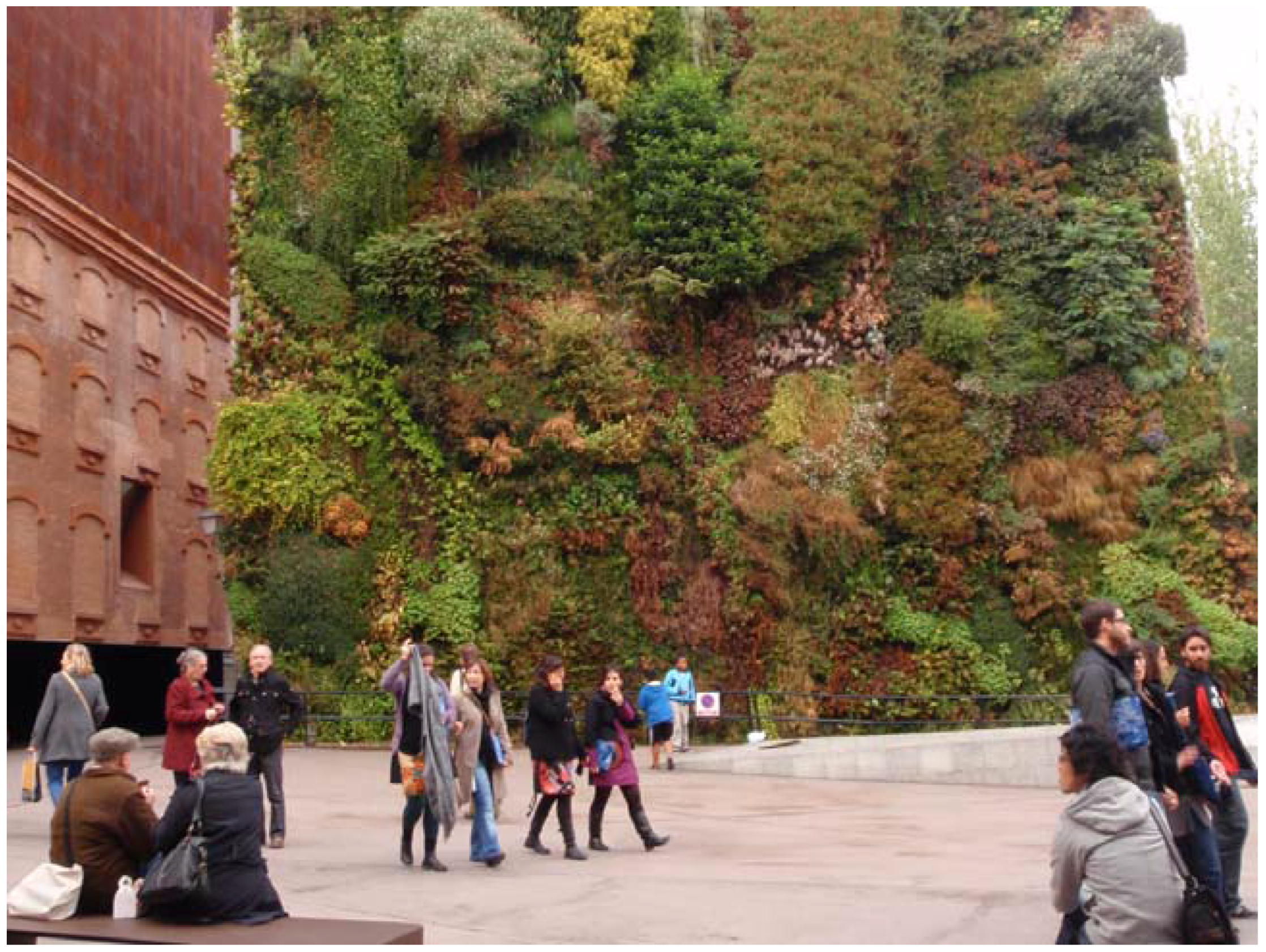
Harvest  | Measures that relate to the infrastructural strategy of ‘harvest’ can be generally characterized by their capacity to catch and collect rainwater before contributing to stormwater runoff. Collected rainwater can replace or supplement treated water of potable quality, thus contributing to the reduction of a city’s demand for water supply. It can further extend supplies from regional reservoirs and restore environmental flows in rivers used for water supply [47]. It is therefore a particularly interesting infrastructural strategy to be applied in urban situations of water scarcity. It is also an especially attractive infrastructural strategy to face groundwater floods, since rainwater harvesting in upstream catchments can decrease stormwater-driven peak flows and overloads in drainage infrastructure [48]. Harvesting measures can range noticeably in scale and complexity from a single urban fixture to a green wall (Figure 2), such as inverted umbrellas or a community system of green roofs. For example, at Potsdamer Platz in Berlin, a total of 32.000 m2 of roof collects 21 inches (around 0.5 m) of annual rainfall and stores it in a 3.500 m3 tank (UNEP 2011 in [49]). |
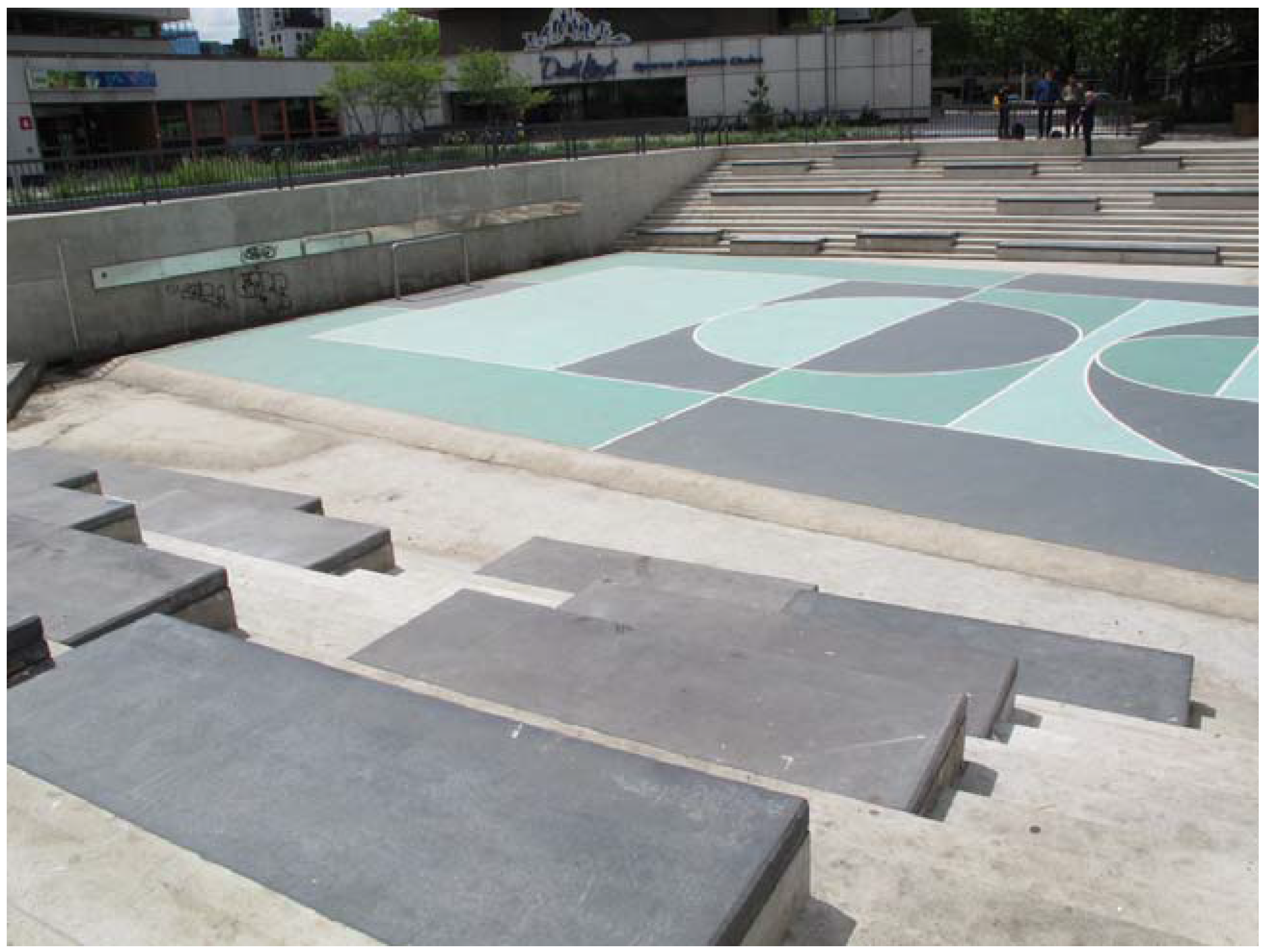
Store  | Measures that entail the infrastructural capacity to ‘store’ water also contribute to the minimization of overall urban runoff and pressure alleviation upon existing infrastructural systems. This type of measure can be designed to store water either above or belowground. When comprised with appropriate vegetation and depending on the design detention time, stored water can be additionally filtered and purified, thus potentially providing water with improved quality. It has been further evidenced that rainwater collected from roofs improves its quality by storage in tanks [50]. Measures with the capacity to store water also vary in scale and complexity. Raingardens or bioswales are relatively small and straightforwardly implemented when compared to wet bioretention basins or regulation reservoirs. Although compact urban territories are unlikely to have the available space for the implementation of larger-scale measures, alternatives exist in order to store water in densely-urbanized areas. An exemplary case regarding the formerly mentioned situation is the water plaza at Rotterdam in the Netherlands, designed by De Urbanisten office (Figure 3). The total surface area encompassed within this project is 9.500 m2, including street and parking. The actual water square has an area of 5.500 m2 and offers 1.800 m3 of temporal water storage [51]. |
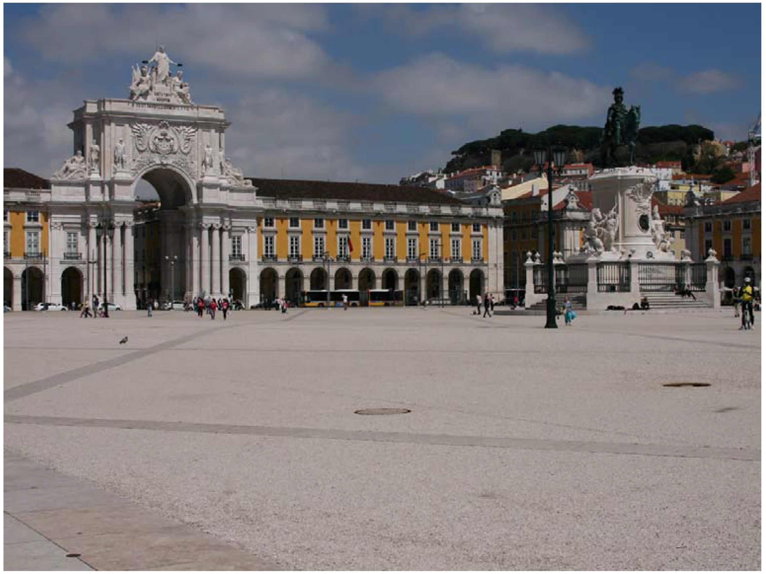
Infiltrate  | Measures that encompass the flood adaptation infrastructural strategy to ‘infiltrate’ stormwater include trenches, basins or permeable pavements that enhance the intrusion of water into subsoil layers or into other types of storage or conveyance measures. The porous paving illustrated in Figure 4, for example, composed of limestone gravel and stone dust compressed with a colorless synthetic binder, drains stormwater into the underneath drainage system. Measures primarily targeted at the infrastructural strategy to ‘infiltrate’ generally entail filtration mediums, such as gravel and rock, which treat stormwater and lead it into substratal soils. Yet, the particular function to infiltrate into subsoil layers is more effective when measures are combined with other measures specifically related to the functions of harvest or store in order to effectively pre-treat stormwater [52]. Through correctly implemented infiltration processes, it is therefore not only possible to remove a great range of pollutants, such as suspended solids or heavy metals, but also to promote the recharge of groundwater aquifers and, thus, support water supply sources [53]. In similarity to storage measures, infiltration measures may therefore also substantially reduce runoff volumes. For example, the infiltration trench implemented below Elmer Avenue is capable of capturing 750,000 gallons of runoff [54]. |
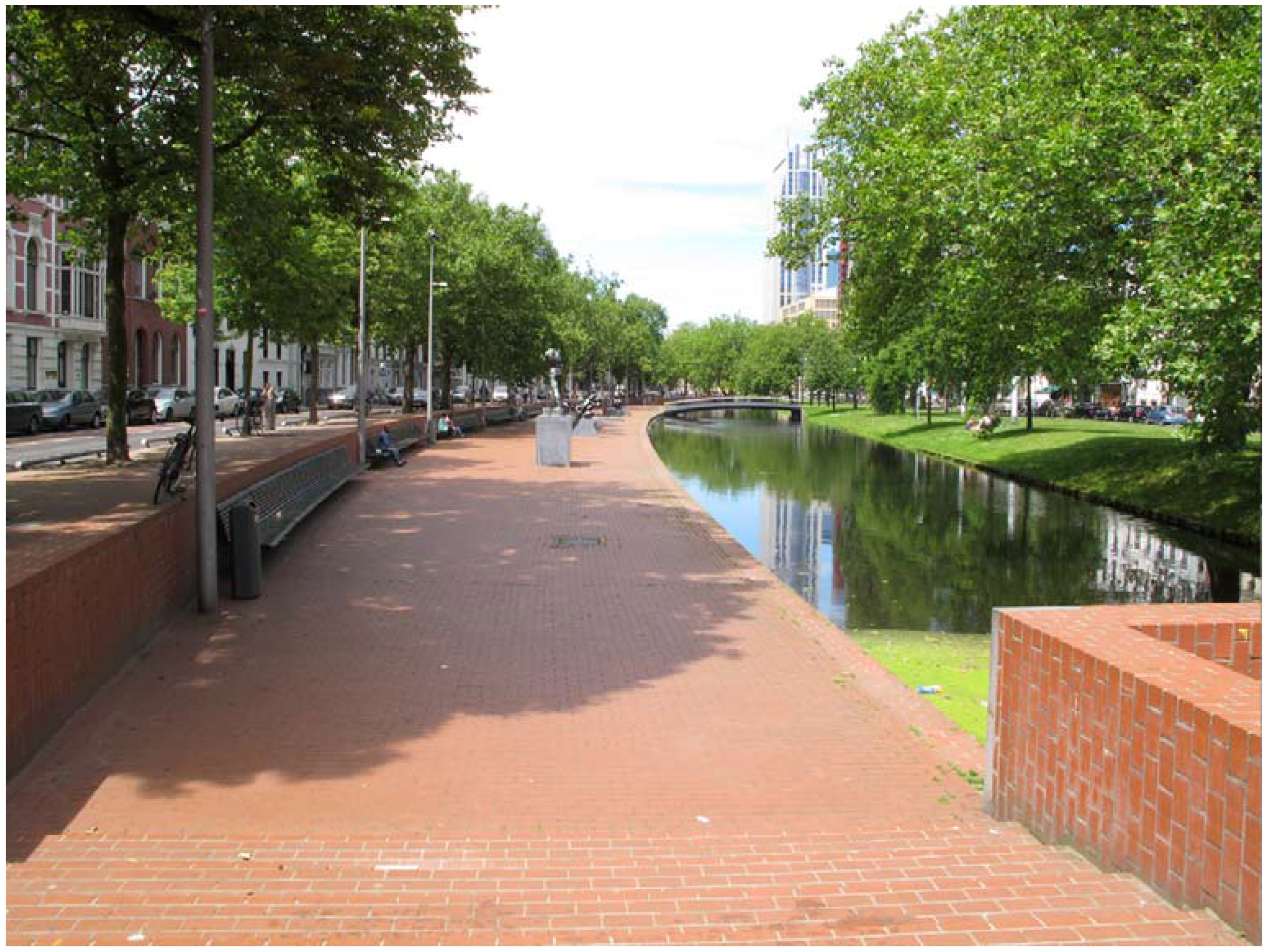
Convey  | The infrastructural strategy of ‘convey’ is related to the process of transporting stormwater through channels. These channels may vary in size and nature, such as from large and environmentally-sound rivers to small artificial street channels. In the scope of this research, measures that include fast conveyance systems, such as traditional underground drainage infrastructure whose primary objective is to drain water as quickly as possible, are not included, as they do not entail any relation with public space design. When comprising appropriate vegetation, measures entailed within this strategy may additionally offer the complementary benefits of water depuration and amenity value [43]. Measures that encompass this infrastructural strategy include, among others, the daylighting of streams, such as the case of Westersingel channel at Rotterdam, the Netherlands (Figure 5) or the Cheonggyecheon river. In the latter, resulting benefits encompass the capacity to sustain a flow rate of 118 mm/h and flood protection for up to a 200-year flood event [55]. |
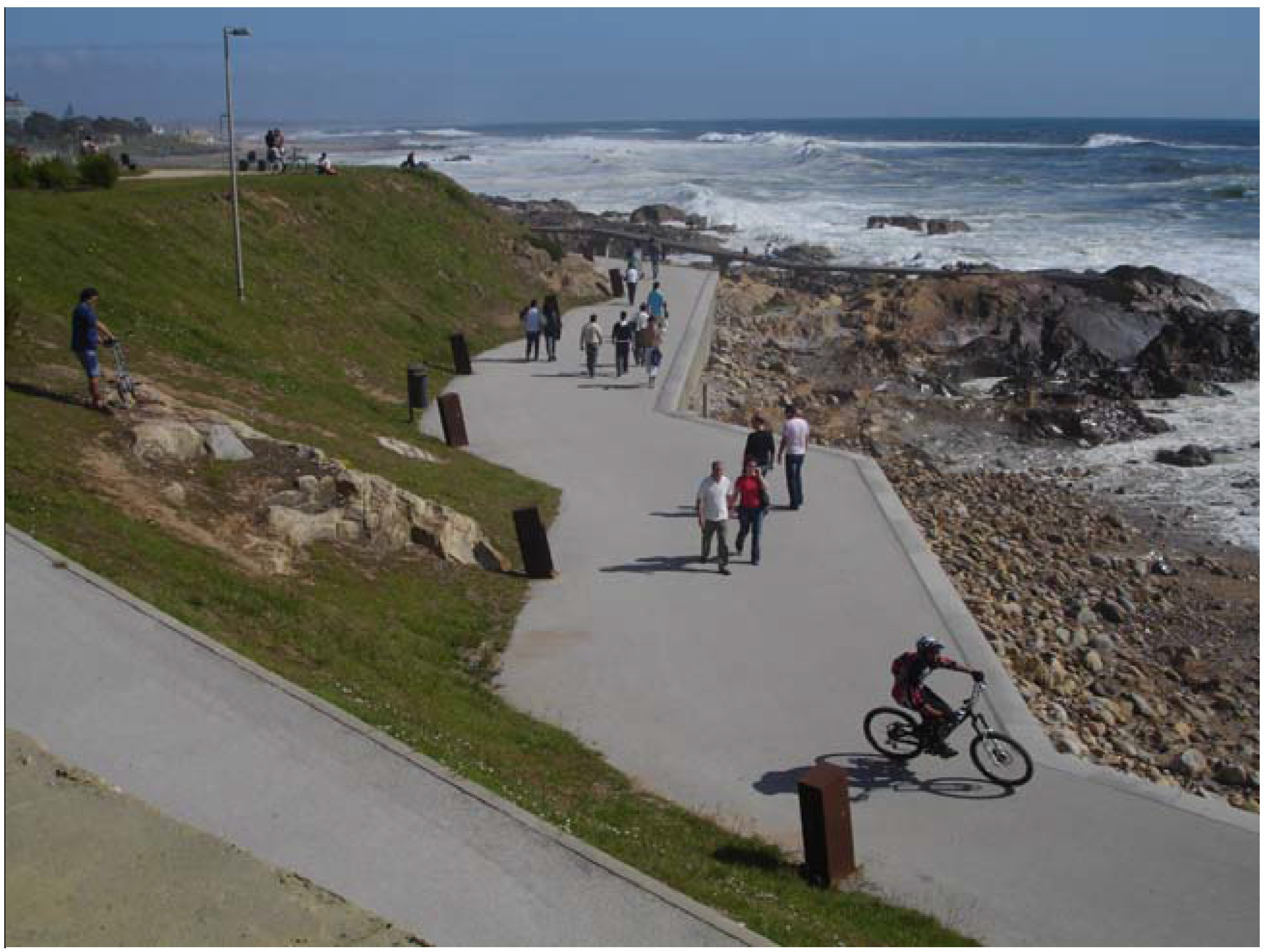
Tolerate  | Measures that entail the infrastructural capacity to ‘tolerate’ are generally characterized by their ability to occasionally endure water excess from periodic flood events. These measures include both old know-how, such as the construction of elevated structures, as well as innovative designs, such as floating systems. The Yongning River Park, for example, designed to sustain up to a 50 year flood event, encompasses a floating platform for public use above the seasonally-flooded natural wetland [56]. Through this platform, people can more closely enjoy and learn from natural processes even during a flood event. The employment of measures capable of tolerating flood water excesses can be less welcomed for cultural reasons, and this fact must be taken into consideration within the design process [57]. Moreover, the application of measures with this particular purpose must bear in mind the perquisite of using strong and resistant materials in order to maintain its utility during and after storm events. In the case of submergible parks or pathways, urban fixtures, such as benches or lamps, should be effectively attached to the ground as in the case of Passeio Atlântico at Porto in Portugal illustrated in Figure 6. |
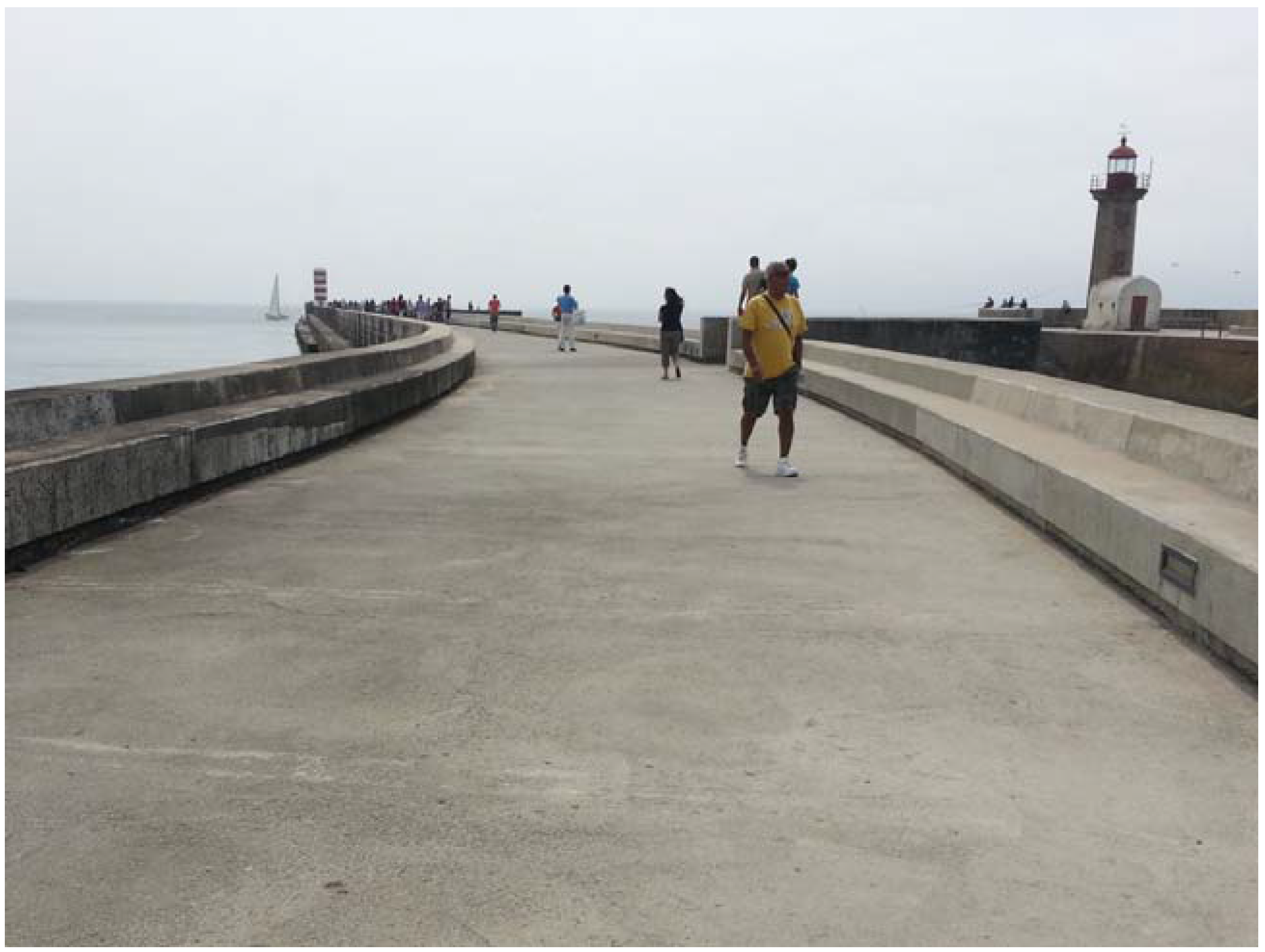
Avoid  | As the name indicates, measures that encompass the infrastructural strategy to ‘avoid’ aim to impede or prevent the presence of stormwater. These measures therefore serve the exact opposite purpose from the previous ‘tolerate’ strategy. They can have small dimensions, such as automatic floodgates applied in building doorways, or they can have very large dimensions, such as a city’s waterfront embankment. They can be of temporary nature, such as removable metal plaques, or of long-lasting value, such as breakwaters. Measures targeted at avoiding the intrusion of stormwater can conciliate hard protective infrastructure with public spaces that promote local awareness and community involvement. Such an approach can be exemplified by the case of glass flood walls, which are capable of withstanding flood heights up to a typical standard of 1.8 m [58]. This type of measure is of particular interest when enduring flood protection is required in an area where the visual stimulus of a traditional flood wall is undesired. Although large-scale traditional flood defense infrastructure, such as storm surge barriers, may integrate complementary public uses, such as transport facilities or art installations, bearing in mind the scope of this research, these are not here considered. New flood risk management paradigms present additional possibilities that are integrated with the design of public spaces. That is namely the case of urban multifunctional defenses, such as Zaha Hadid’s design for the Hamburg river promenade, which integrates road infrastructure and promenade parking lots, restaurants and kiosks. One can also refer to the example of ‘Molhe da Barra do Douro’, a robust pier that combines aboveground benches and an interior area below for inside facilities (Figure 7). |
| Number | Examples | Infrastructural Strategy | |||||
|---|---|---|---|---|---|---|---|
| # | Project Name | Harvest | Store | Infiltrate | Convey | Tolerate | Avoid |
| 1 | Caixa Forum plaza | X | X | X | – | – | – |
| 2 | Westblaak’ car park silo | X | X | – | – | – | – |
| 3 | Woolworths Shopping playgr. | X | X | – | – | – | – |
| 4 | North Road | X | X | – | – | – | – |
| 5 | Expo Boulevard | X | X | – | – | – | – |
| 6 | Jawaharlal Planetarium Park | X | X | – | – | – | – |
| 7 | Dakpark | X | X | X | – | – | – |
| 8 | Promenade Plantée | X | X | – | – | – | – |
| 9 | European Patent Office | X | X | – | – | – | – |
| 10 | Womans University | X | X | X | – | – | – |
| 11 | High Line Park | X | X | X | – | – | – |
| 12 | Walter Bos Complex | X | X | – | – | – | – |
| 13 | Stephen Epler Hall | X | X | – | – | – | – |
| 14 | Parc de Diagonal Mar | – | X | – | – | X | – |
| 15 | Parc del Poblenou | – | X | – | – | X | – |
| 16 | Benthemplein square | X | X | – | – | X | – |
| 17 | Tanner Springs Park | X | X | – | – | X | – |
| 18 | Parc de Joan Miró | X | X | – | – | – | – |
| 19 | Escola Industrial | – | X | – | – | X | – |
| 20 | Potsdamer Platz | X | X | – | X | – | – |
| 21 | Museumpark car park | – | X | – | – | X | – |
| 22 | Place Flagey | – | X | – | – | X | – |
| 23 | Stata Center | – | X | X | – | – | – |
| 24 | The Circle | X | X | – | – | – | – |
| 25 | Georgia Street | – | X | X | X | – | – |
| 26 | Parque Oeste | X | X | X | X | X | – |
| 27 | Qunli park | X | X | X | – | X | – |
| 28 | Emerald Necklace | X | X | X | X | X | – |
| 29 | Quinta da Granja | X | X | X | – | X | – |
| 30 | Parque da Cidade | X | X | X | X | X | – |
| 31 | Trabrennbahn Farmsen | X | X | X | X | – | – |
| 32 | Elmhurst parking lot | X | X | X | X | – | – |
| 33 | Ecocity Augustenborg | X | X | X | X | – | – |
| 34 | Museum of Science | X | X | X | X | – | – |
| 35 | High Point 30th Ave | X | X | X | X | – | – |
| 36 | Moor Park | X | X | X | X | – | – |
| 37 | Ribblesdale Road | X | X | X | X | – | – |
| 38 | South Australian Museum | X | X | X | – | – | – |
| 39 | Columbus Square | X | X | X | X | – | – |
| 40 | Derbyshire Street | X | X | X | X | – | – |
| 41 | Onondaga County | X | X | X | X | – | – |
| 42 | Edinburgh Gardens | X | X | X | – | X | – |
| 43 | Taasinge Square | X | X | X | – | X | – |
| 44 | Australia Road | X | X | X | – | X | – |
| 45 | East Liberty Town Square | X | X | X | – | – | – |
| 46 | Can Caralleu | X | X | X | – | – | – |
| 47 | Zollhallen Plaza | X | X | X | – | X | – |
| 48 | Green park of Mondego | X | X | X | – | X | – |
| 49 | Bakery Square 2.0 | X | X | X | X | X | – |
| 50 | Praça do Comércio | – | X | X | – | X | – |
| 51 | Percy Street | – | X | X | – | X | – |
| 52 | Greenfield Elementary | – | X | X | – | X | – |
| 53 | Etna Butler Street | – | X | X | – | – | – |
| 54 | Community College | – | X | X | – | – | – |
| 55 | Elmer Avenue Neighborhood | – | X | X | X | – | – |
| 56 | Rio Besòs River Park | X | X | X | X | X | – |
| 57 | Ribeira das Jardas | X | X | X | X | X | – |
| 58 | Ahna | X | X | – | X | – | – |
| 59 | River Volme | – | X | – | X | – | – |
| 60 | Promenada | – | – | – | X | X | – |
| 61 | Catharina Amalia Park | X | X | X | X | X | – |
| 62 | Kallang River | X | X | X | X | X | – |
| 63 | Alb | X | X | X | X | X | – |
| 64 | Westersingel | X | X | X | X | X | – |
| 65 | Thornton Creek | X | X | X | X | X | – |
| 66 | Cheonggyecheon River | X | X | X | X | X | – |
| 67 | Soestbach | – | X | – | X | – | – |
| 68 | Banyoles | – | X | – | X | X | – |
| 69 | Freiburg Bächle | – | X | – | X | X | – |
| 70 | Roombeek | X | X | – | X | – | – |
| 71 | Solar City streets | – | X | – | X | – | – |
| 72 | Pier Head | – | X | – | X | X | – |
| 73 | Olympic park | X | X | X | X | X | – |
| 74 | Kronsberg | X | X | X | X | X | – |
| 75 | Renaissance Park | X | X | – | X | X | – |
| 76 | 21st Street | X | X | X | X | X | – |
| 77 | West India Quay | – | – | – | – | X | – |
| 78 | Ravelijn Bridge | – | – | – | – | X | – |
| 79 | Yongning River Park | X | – | – | – | X | – |
| 80 | Landungsbrücken pier | – | – | – | – | X | – |
| 81 | Spree Bathing Ship | – | X | – | – | X | – |
| 82 | Leine Suite | – | – | – | – | X | – |
| 83 | Rhone River Banks | X | X | X | X | X | – |
| 84 | Parque fluvial del Gallego | X | X | X | X | X | – |
| 85 | Buffalo Bayou Park | X | X | X | X | X | – |
| 86 | Parc de la Seille | X | X | X | X | X | – |
| 87 | Park Van Luna | X | X | – | X | X | – |
| 88 | Passeio Atlântico | – | – | – | – | X | X |
| 89 | Quai des Gondoles | X | – | – | – | X | – |
| 90 | Elster and Pleiβe Millraces | – | – | – | X | X | – |
| 91 | Terreiro do Rato | – | – | – | X | X | – |
| 92 | Waterfront promenade | X | – | – | X | X | – |
| 93 | Elbe promenade | – | – | – | – | X | X |
| 94 | Dike of ‘Boompjes’ | X | X | X | – | X | X |
| 95 | Zona de Banys del Fòrum | – | – | – | – | X | X |
| 96 | Molhe da Barra do Douro | – | – | – | – | X | X |
| 97 | Jack Evans Harbour | – | – | – | – | X | X |
| 98 | Schevenigen | – | – | – | – | X | X |
| 99 | Blackpool Seafront | – | – | – | – | X | X |
| 100 | Sea organ | – | – | – | – | X | X |
| 101 | Main riverside | – | – | – | – | X | X |
| 102 | Westhoven | – | – | – | – | X | X |
| 103 | Wallkade promenade | – | – | – | – | X | X |
| 104 | Landungsbrücken building | – | – | – | – | X | X |
| 105 | Corktown Common | X | – | X | – | X | X |
© 2016 by the authors; licensee MDPI, Basel, Switzerland. This article is an open access article distributed under the terms and conditions of the Creative Commons Attribution (CC-BY) license (http://creativecommons.org/licenses/by/4.0/).
Share and Cite
Matos Silva, M.; Costa, J.P. Flood Adaptation Measures Applicable in the Design of Urban Public Spaces: Proposal for a Conceptual Framework. Water 2016, 8, 284. https://doi.org/10.3390/w8070284
Matos Silva M, Costa JP. Flood Adaptation Measures Applicable in the Design of Urban Public Spaces: Proposal for a Conceptual Framework. Water. 2016; 8(7):284. https://doi.org/10.3390/w8070284
Chicago/Turabian StyleMatos Silva, Maria, and João Pedro Costa. 2016. "Flood Adaptation Measures Applicable in the Design of Urban Public Spaces: Proposal for a Conceptual Framework" Water 8, no. 7: 284. https://doi.org/10.3390/w8070284