Article

Mg2+-Based Method for the Pertuso Spring Discharge Evaluation

by
Giuseppe Sappa
*,
Flavia Ferranti
,
Francesco Maria De Filippi
and
Giulia Cardillo
DICEA—Department of Civil, Building and Environmental Engineering, Sapienza University of Rome, Rome 00184, Italy
*
Author to whom correspondence should be addressed.
Water 2017, 9(1), 67; https://doi.org/10.3390/w9010067
Submission received: 27 October 2016 / Revised: 24 December 2016 / Accepted: 18 January 2017 / Published: 23 January 2017
(This article belongs to the Special Issue Groundwater Monitoring and Remediation)

Abstract

:
This paper deals with the Environmental Monitoring Plan concerning the catchment work project of the Pertuso karst spring, which is going to be exploited to supply an important drinking water network in the south part of Roma district. The Pertuso Spring, located in the Upper Valley of the Aniene River, is the main outlet of a large karst aquifer, which is one of the most important water resources in the southeast part of Latium Region, Central Italy, used for drinking, agriculture, and hydroelectric supplies. The environmental monitoring activities provided data about one spring and two cross-sections of the Aniene River, from July 2014 to May 2016. A combined approach based on discharge measurements and hydrogeochemical analysis has been used to study flow paths and groundwater–surface water interaction in the study area. Tracer methods are particularly suitable in hydrogeological studies to assess transit times and flow properties in karst aquifers. The analysis of solute contents in the sampling points brought forth the identification of the Mg2+ ion as a conservative tracer in this specific system and, consequently, to the development of a conceptual model based on chemical mass balance for the Pertuso Spring discharge evaluation.

1. Introduction

Groundwater represents a vital resource for the society, and also for the ecosystems. The interest of researchers for better understanding the groundwater origin, the subsurface processes, and the factors controlling the residence time has gradually increased, and the investigation techniques evolved continuously [1], in the aim of better protecting these resources.
The increasing anthropogenic activities and the impacts of climate change are identified as being responsible for karst groundwater depletion [2,3]. Thus, groundwater exploitation in karst aquifers requires special management strategies to prevent their quality and quantity depletion and to support decision-making for water resources management [4,5].
Karst aquifers have complex and original characteristics, which make them very different from other aquifers: high heterogeneity of the rock matrix, large voids, high flow velocities (up to several hundreds of m/h), and high flow rate springs (up to some tens of m3/s) [6].
In karst aquifers, where flow may be concentrated in subsurface conduits, a Darcy law approach is usually not suitable [7] and karst springs discharge is not easily measurable by standard techniques or conventional instruments. Sometimes, channels are unsuitable for metering the flow, being shallow, choked with vegetation, and with ill-defined banks [8]. In these aquifers, the drainage network typically develops in a system of conduits that flows into a single trunk that discharges through the spring [9]. However, some karst aquifers may have a spread flow pattern, which is related to the enlargement of fractures and smaller conduits—located near the stream discharge boundary—or to the collapse of an existing trunk conduit [10].
Underflow springs are often hidden, for example, by rising in the bed of the surface stream [11]. Thus, even if it is possible to identify, like in this case, the outlet section of a karst spring, where all of the groundwater discharge comes out, sometimes this is not true and it is not clear where the entire discharge comes out. On the other hand, seasonal changes throughout the year can make difficult or impossible to access cross-sections to carry out traditional measurements. Consequently, the difficulty in measuring karst spring discharge implies that the use of the traditional current-meter method may be limited and less reliable, sometimes leading to erroneous results [12].
In this sense, tracer methods are particularly suitable to assess flow properties in karst aquifers, also because the necessary equipment is manageable [13].
Environmental tracers are used more and more often in hydrological studies, in order to have a complete view about the water cycle, the groundwater recharge, the water–rock interactions, the geochemical processes [1], and, moreover, to understand potential groundwater contamination processes [14].
In recent years, surface water and groundwater tracing techniques have been used in a variety of complex hydrogeological settings to aid in characterizing groundwater flow systems [7,15,16,17,18].
Groundwater tracers include any substance that can become dissolved or suspended in water, or attached to the water molecule, and recovered or measured from a water sample that can be used to trace the source of groundwater in terms of its specific or relative location and time of recharge. Groundwater tracers can include both artificially introduced and naturally occurring substances [19,20,21].
An important class of tracers are the ionic tracers, as they are not subject to decay or gas exchange [22]. Moreover, biogeochemical reactions can modify concentrations of most ions [23].
The number of ion types which might be used is very large. However, because of low cost, ease of detection, and low sorption, chloride (Cl) and bromide (Br) are most popular [24]. However, other ions can be used from time to time for special purposes, such as Li+, NH4, NO3, Mg2+, K+, and I.
The aim of this work is to apply the potentiality of Mg2+ as a natural tracer in the karst system of the Upper Valley of the Aniene River, to support a conceptual model for the Pertuso Spring discharge evaluation [25].
In particular, starting from hydrogeochemical analysis results, the developed model uses a magnesium mass balance to evaluate the spring discharge.
Calcium and magnesium offer special promise as seepage tracers for basins set in thick calcareous glacial drift, or doline basins set in carbonate-rich areas. Magnesium is also an obvious tracer in areas of ultramafic rock. In humid regions with abundant dolomite, Mg2+ offers advantages over Ca2+ as a tracer because, once in solution, it does not re-form a carbonate unless Mg2+/Ca2+ > 2 [26].
On the other hand, the increase in Mg2+ concentration values, and hence Mg2+/Ca2+ ratio, not only depends on the dissolution/precipitation reaction of calcite and dolomite, but also an increase in water temperature, which accelerates the kinetics of the dissolution of dolomite. Moreover, in this process, the lower hydraulic conductivity of dolomites, compared with that of limestones, favors the Mg2+ concentration increasing, as the water–rock interaction is longer [12,27]. In the past, magnesium was used as a tracer to evaluate the steady-state influx to seepage lakes by using a solute mass balance. For lakes set in the dolomitic glacial drift of Wisconsin, Mg2+ was an ideal groundwater tracer, both because it has the highest ratio of groundwater concentration to concentration in precipitation and because it behaves nearly conservatively in lakes set in semi-humid climates [26].
Bencala et al. (1987) [28] and Schemel et al. (2006) [29] made comparisons of environmental tracers at the confluence of two streams in Colorado and studied, through the tracer’s mass balance, the behavior of naturally occurring calcium, magnesium, silica, sulfate, fluoride, and manganese; they concluded that magnesium exhibited conservative or nearly conservative behavior.
It is quite important to underline that a conservative behavior may depend on site-specific environmental conditions. Generally, for conservative solute tracers, it has to be expected that there is a simple physical attenuation mechanism due to dilution, whereas any chemical attenuating mechanism would remove non-conservative solute in varying amounts [28].
Most recently, it was showed that variations in chlorofluorocarbon (CFC), 222Rn, and Mg2+ concentrations within streams can be used to quantify rates of groundwater inflow. A mass balance that takes into account changes in solute load within a stream receiving groundwater inflow has been proposed [23].
Thus, in several studies, Mg2+ presented the right qualities to be used as a conservative or nearly conservative tracer [26,28,29]. Particularly, in this study, Mg2+ has proved to be a useful tracer for chemical mass balance techniques, which are often necessary in order to assess surface water or groundwater flow in karst hydrology settings, where conventional measurements are more difficult.

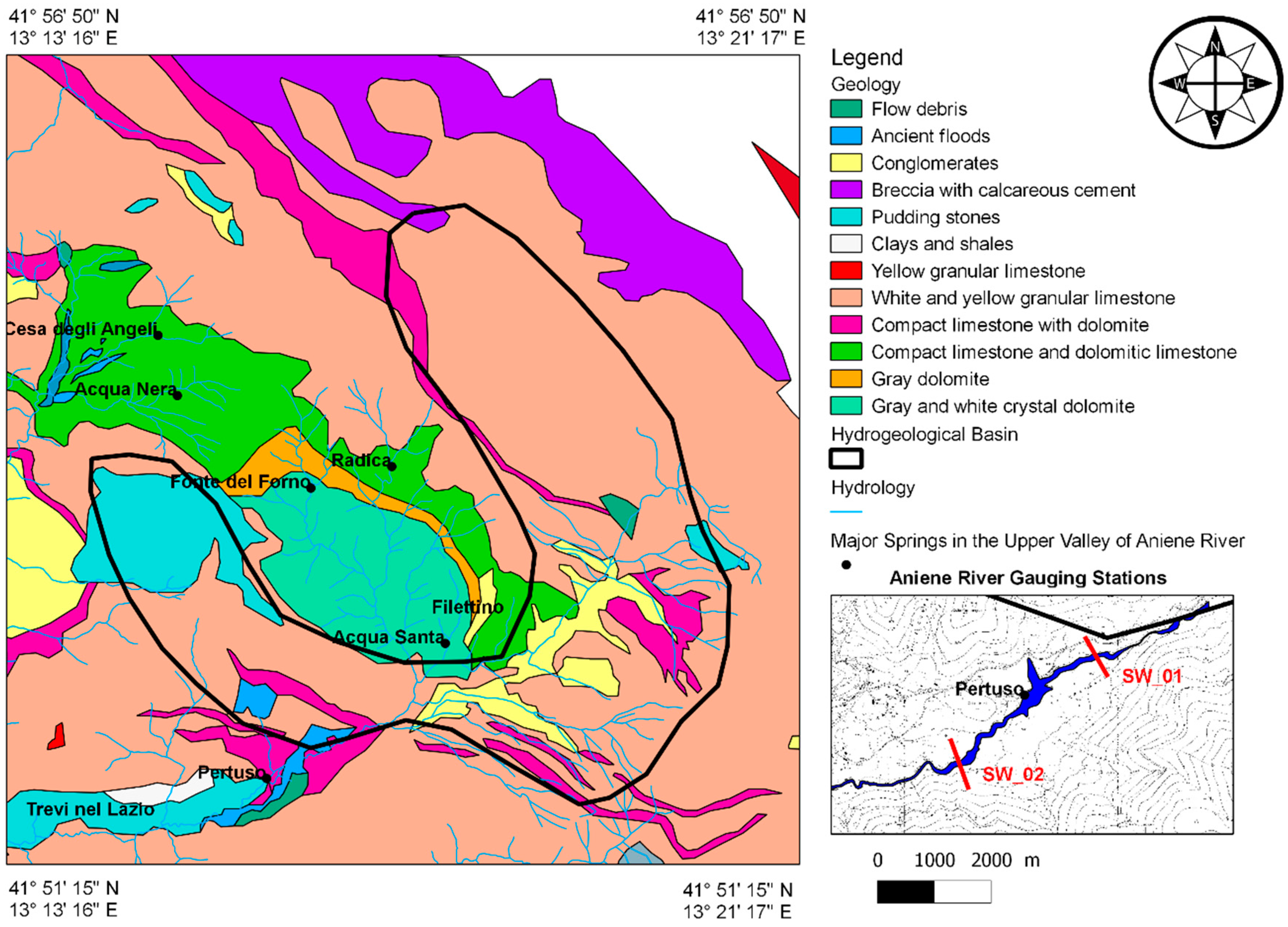
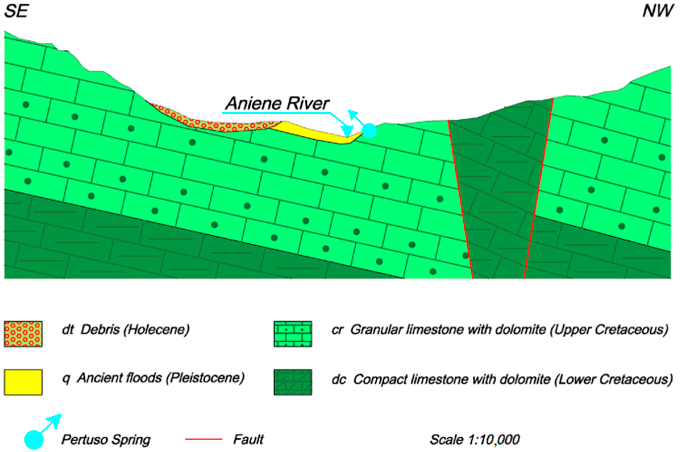
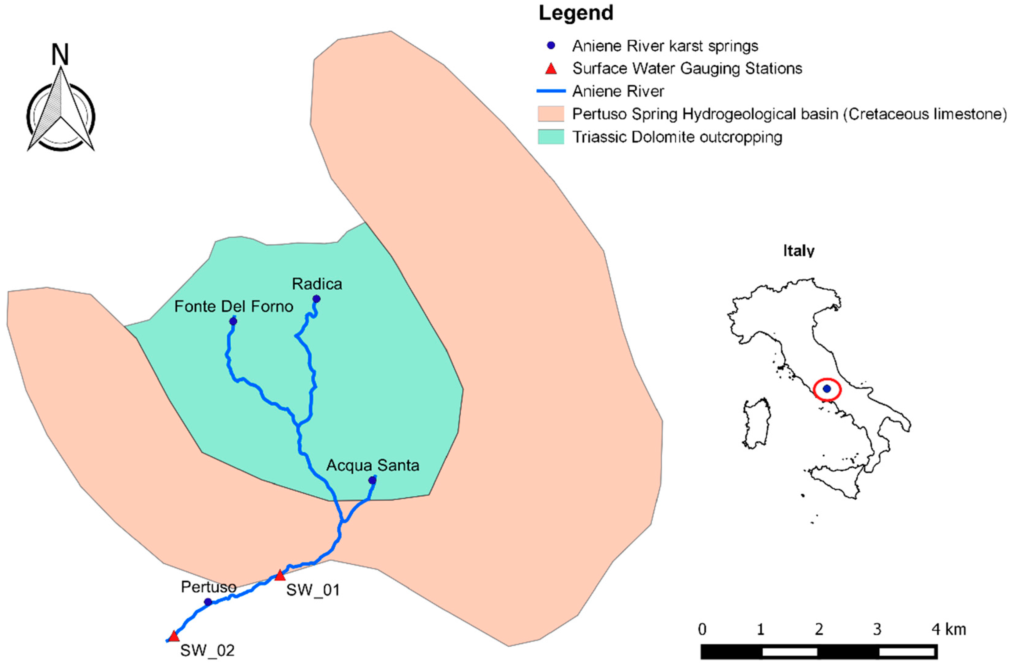
2. Geological and Hydrogeological Setting

The Latium Region has several springs, under-lake springs, and shows groundwater with deep water tables. The most important groups of springs are in the Upper Valley of the Aniene River, in the Monti Lucretili area, in the Bracciano lake area, and in Genzano, Cecchignola, Grottarossa, and Castel Giubileo areas [30]. The Pertuso Spring, in the Upper Valley of the Aniene River, supplies drinking water to the city of Rome and feeds the Comunacqua hydroelectric power plant, owned by ENEL group [31].
The Pertuso Spring is sited about 1 km down from the confluence of the Fiumata Valley and the Granara Valley, from where the Valley of the Aniene River starts, close to the boundary of the carbonate hydrogeological system [32]. In fact, the Aniene basin is composed almost entirely of bare Mesozoic, highly fractured, karstified carbonate rocks of the central Apennine range [33].
This area is mostly made of highly permeable Cretaceous carbonate rocks, deeply fractured and mostly soluble (Figure 1).
The base of the stratigraphic series is made of Upper Cretaceous carbonates, represented by the alternation of granular limestone and dolomites layers. Above these ones lie Quaternary fluvial and alluvial deposits, downward pudding, and Miocene clay and shale [33]. The lithostratigraphy, detected in nearby Subiaco Station, confirms the presence of an extensive karst area, particularly limestones and dolomites (Latium-Abruzzi succession, Upper Triassic-Upper Miocene) [34]. The most important karst landforms are rutted fields, Karren, sinkholes, and swallow holes. The karst surface is very permeable and enables the rapid infiltration of rainfall into the underground system, where the carbonate dissolution generates cavities [35,36,37]. Dissolution conduits strongly influence groundwater flow and evolve into complex networks, often crossing several kilometres throughout the limestone matrix [38]. Physical and chemical variations that occur during storm events indicate the complex dynamic processes in the karst aquifer and the role undertaken by the epikarst as perched water reservoir, and by the major conduits that develop through the vadose and saturated zones of the karst system [34]. Thus, the Pertuso Spring is the natural outcrop of groundwater discharging from these conduits, coming from an approximately 50 km2 area (Figure 1) [38], and it comes out when this aquifer, made of this highly enhanced karst network, matches topographic surface (Figure 2). The discharge of this karst spring is usually rapid and displays pronounced peaks following recharge events. These peculiar properties heighten the vulnerability of karstic aquifers and the groundwater emerging from them [39].

3. Materials and Methods

The water sampling survey was carried out during the two years of monitoring of the Environmental Monitoring Plan, related to the catchment project of the Pertuso Spring, from July 2014 to May 2016. Eighteen water samples have been collected from three sampling points within the study area: one from the Pertuso Spring, the others from two gauging stations located along the Aniene River, respectively, upstream (SW_01) and downstream (SW_02) the spring (Figure 1). These gauging stations belong to the monitoring network set up for the Environmental Monitoring Plan, in agreement with the Ministerial Decree 260/2010, which focuses on the sensitive connections between surface water and groundwater [38]. According to the Environmental Monitoring Plan, groundwater and surface water have been monitored seasonally (4/year) for the first year of monitoring and twice per year for the second one, with the aim of setting up the hydrogeological conceptual model of the karst aquifer [38], and maintaining control of qualitative and quantitative properties of groundwater, depending on seasonal variations [40].
The experimental data were obtained from field investigations and chemical laboratory analyses and compared to historical data coming from previous studies in the same area [41].
Water temperature, electrical conductivity, and pH values were determined in field using HANNA HI9813-6 waterproof handheld meter. Chemical analyses were carried out at the Geochemical Laboratory of Sapienza University of Rome. Water samples were filtered through cellulose filters (0.45 μm), and their major and minor constituents were determined by ion chromatography (IC) by a 761 Professional IC Metrohm (reliability ±2%). Bicarbonate (HCO3) was determined by titration with 0.1 N HCl (reliability ±2%).
For the identification of water types, the chemical analysis data of the spring water samples have been plotted on the Piper diagram using Geochemistry Software AqQA.
Twelve discharge measurements were carried out along the Aniene River in SW_01 and SW_02 by the application of traditional current-meter. They gave results, referring to the depth, ranging between 0.2 m and 0.7 m as they changed according to the seasonal evolution (Figure 3).
According to the U.S. Geological Survey (USGS) procedure, stream discharge has been calculated as the product of the cross-section area by the average stream flow velocity in that cross-section, obtained using a current-meter [42,43]. The main equipment needed to measure the stream flow velocity is a SEBA horizontal axis current-meter F1, having a propeller diameter of 80 mm which, combined with SEBA Z6 pulse counter, allows one to measure velocity between 0.025 m/s and 10 m/s [44]. The SEBA current-meter has been used according to EN ISO 748:2007 requirements [43]. This current-meter method gives the local water velocity in each vertical following the application of a calibration equation between stream velocity, v (cm/s), and the number of spins, n (s − 1).
v = 0.82 + 33.32 n
The karst aquifer system has been studied in order to evaluate factors, which modify the Aniene River flow, due to groundwater–surface water interactions. This hydrochemical characterization, due to rock–water interactions, leads to a groundwater flow pattern, which allows referring groundwater flow to two different feeding parts of the basin: the first one in the Cretaceous limestone, feeding the Pertuso Spring groundwater; the second one in the Triassic dolomite, feeding the surface water upstream the spring.
In this model, a control volume around the Pertuso Spring has been considered. In this control volume, the incoming flows are the discharge Q1, recorded upstream the spring (SW_01), and the discharge QP, characterized by the relative Mg2+ concentration values C1 e CP. The outgoing flow is the Aniene River discharge Q2, characterized by the Mg2+ concentrations C2, recorded at the SW_02 gauging station located downstream the Pertuso Spring.
The study area belongs to a special protected area in the Natural Park of Simbruini Mountains. As a matter of fact, the control volume can be considered free from any anthropic activities and only characterized by a surface water–groundwater interaction in the hypothesis of good mixing. Thus, the SW_02 gauging station discharge values, which come from the contribution of the Pertuso Spring discharge (QP) to the original SW_01 discharge value, can be represented by Equation (2):
Q 2 = Q 1 + Q P
Applying the conservation of mass equation to this closed system, therefore, is Equation (3):
Q 1 C 1 + Q P C P = Q 2 C 2
The parameter n is defined as the percentage of the Pertuso Spring groundwater contribution to total discharge measured.
n = Q P Q 2 = ( C 2 C 1 ) ( C P C 1 ) ,
Combining Equations (3) and (4), we have obtained the discharge of the Pertuso Spring.
Q P = Q 1 n 1 n ,
From Equation (5), it is determined that the discharge rate of the Pertuso Spring depends on the discharge values measured in the gauging station located along the river upstream the spring (Q1) and the Mg2+ concentration values recorded in groundwater and surface water samples (C1, C2, CP).
Thus, thanks to the proposed conceptual model, starting from the Mg2+ concentrations and the upstream discharge, it has been possible to evaluate the Pertuso Spring discharge.

4. Results

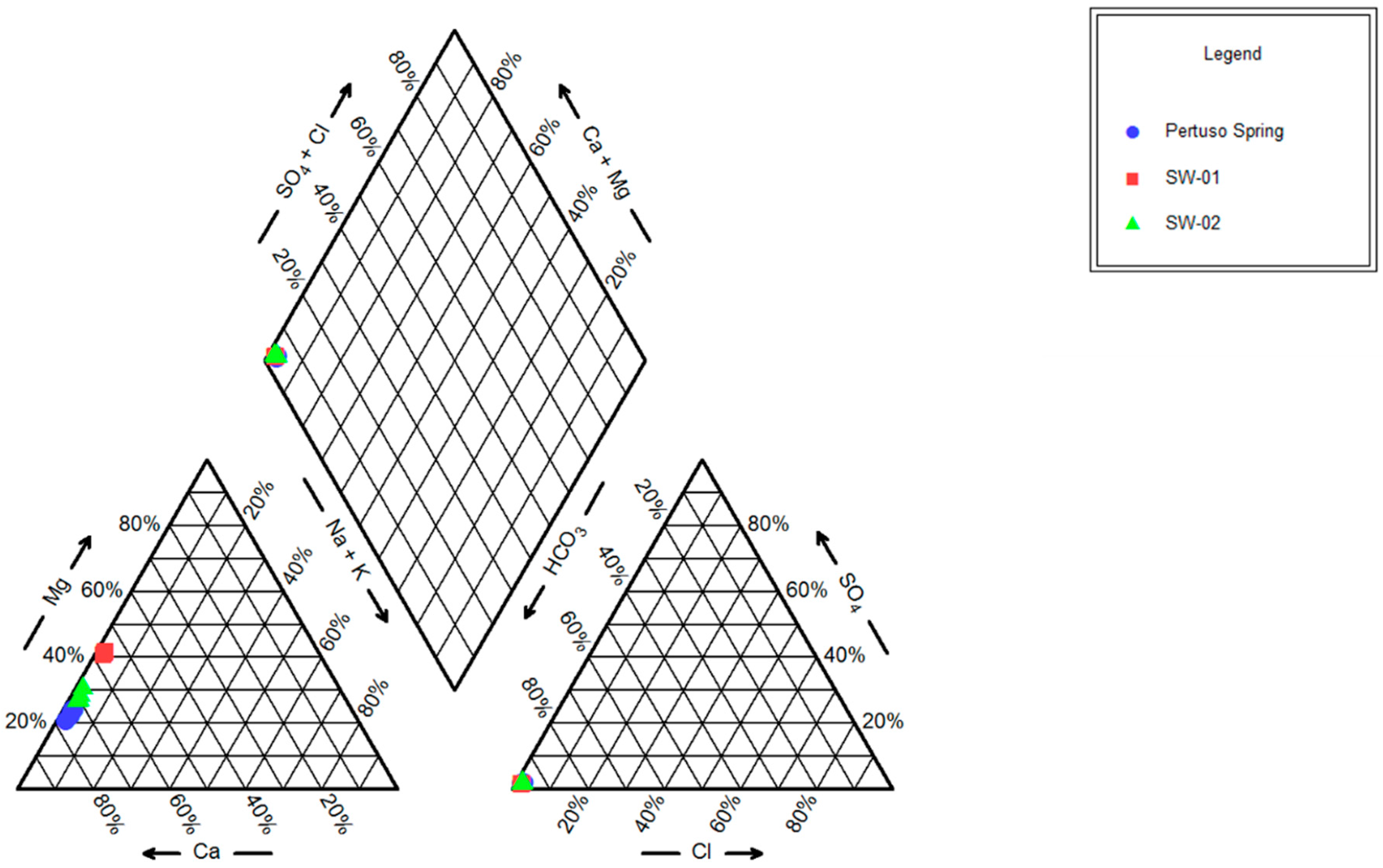
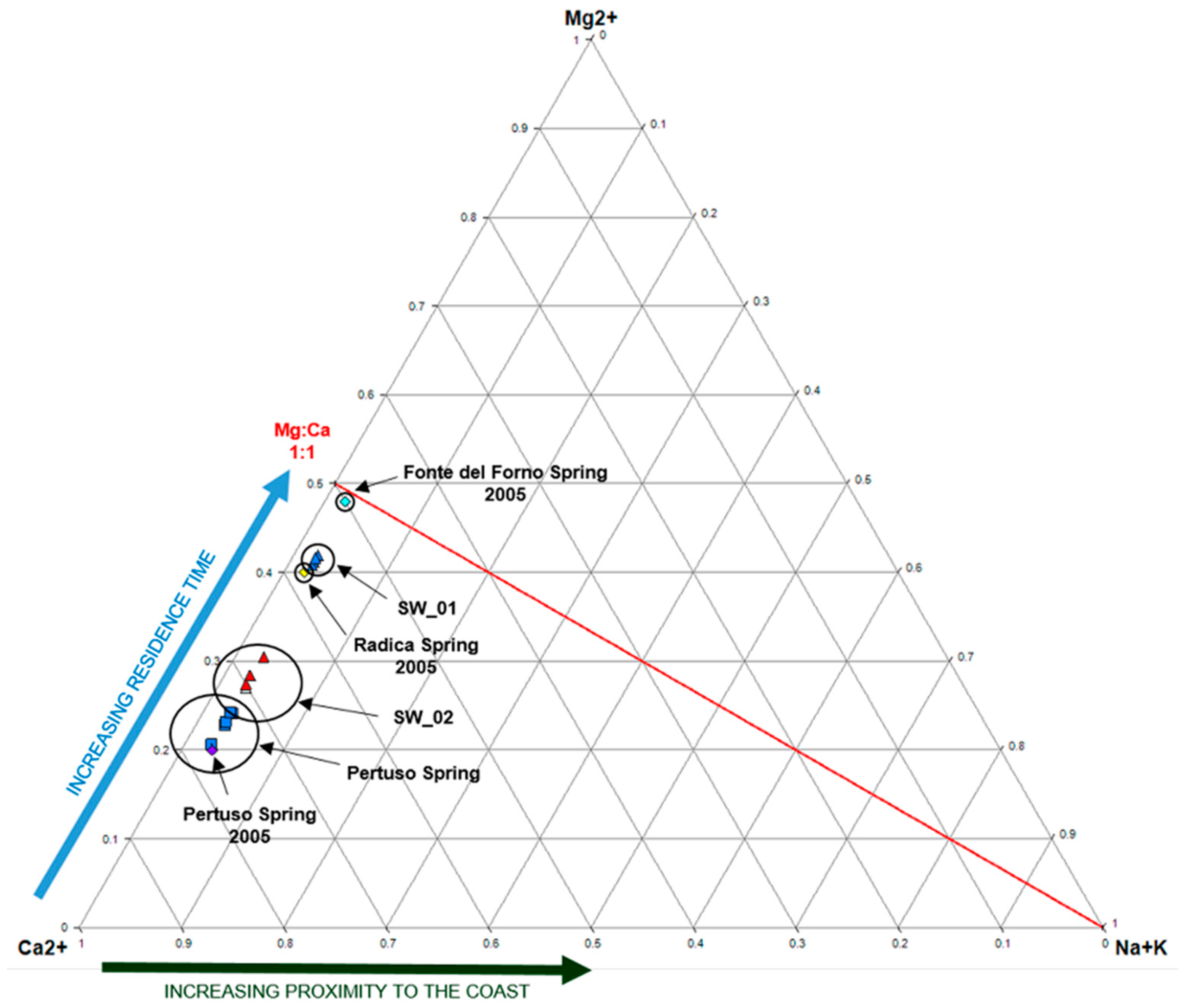
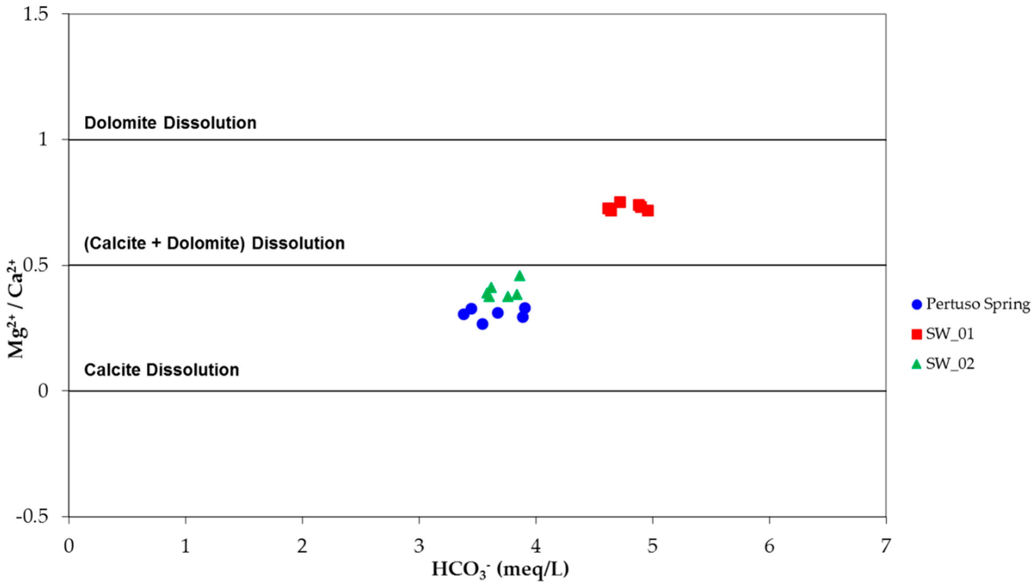
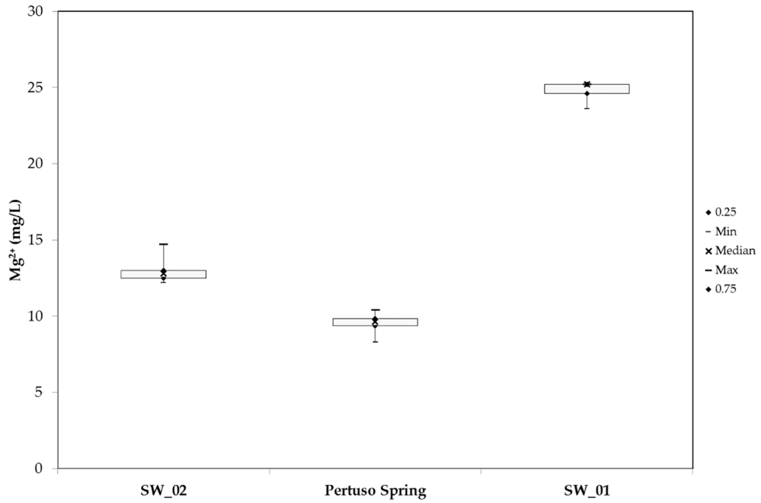
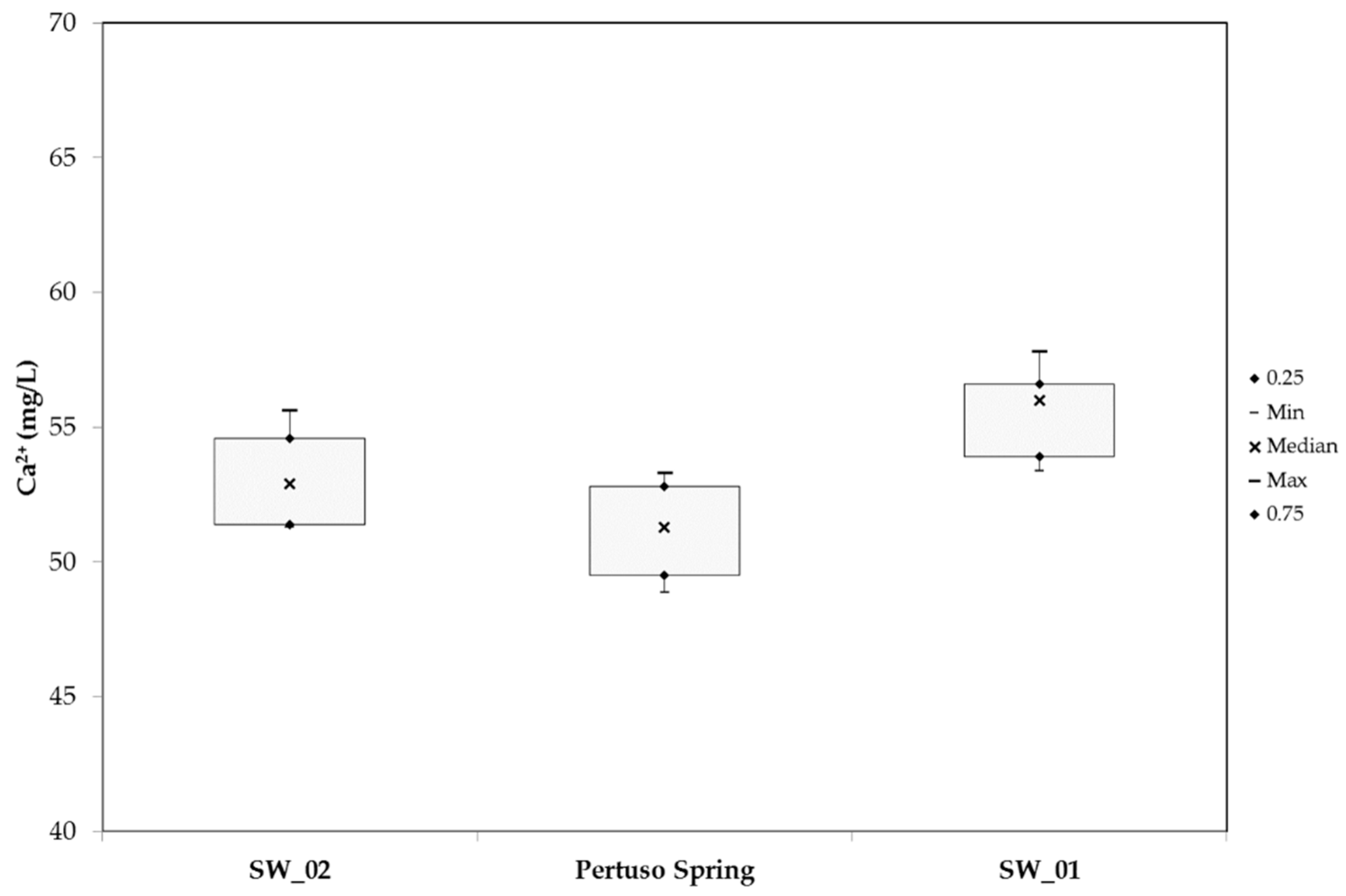
4.1. Hydrogeochemical Results

A statistical summary of the major physicochemical parameters is shown in Table 1.
A combined approach based on discharge measurements and hydrogeochemical data analysis was used to study flow paths and the groundwater–surface water interaction in the study area. Ca2+, Mg2+, and HCO3 represent more than 80% of the dissolved solids in water samples. These high concentrations are mostly due to the dissolution of carbonate minerals, forming limestone, which are the most dominant formations outcropping in the study area. The hydrochemical facies of groundwater and surface water were studied by plotting the concentrations of major cations and anions in the Piper trilinear diagram (Figure 4) [45].
Based on the dominance of major cationic and anionic species, two hydrochemical facies have been identified: (1) Ca-Mg-HCO3 and (2) Ca-HCO3. These results are due to the presence of limestone, dolomitic limestones, and dolomites outcropping in the study area. Water samples coming from SW_01 gauging station present higher values of Mg2+ concentration, while those coming from the Pertuso Spring are definitely poorer in it, and show a clear composition of Ca-HCO3 water type (Figure 3). The different hydrochemical facies between groundwater and surface water reflects on the high concentration of Mg2+ in the Aniene River. These hydrochemical facies highlight that carbonate weathering processes (e.g., calcite and dolomite) are the most important factors of the observed water type.
To study the difference in Mg2+ content between groundwater and surface water, a ternary diagram of cations (Ca2+, Mg2+, and Na+ + K+) [46] was used to highlight how the weathering type processes influence the enrichment in magnesium (Figure 5).
As shown in Figure 5, all samples are placed along the Ca2+-Mg2+ side of the diagram; these groundwater samples are very poor in Na+ and K+. The higher Mg2+ concentrations in SW_01 water samples suggests an increased residence time, depending on the dissolution/precipitation reactions of calcite and dolomite, which occur in the aquifer part, where groundwater crosses dolomitic sandstones.
As a matter of fact, according to previous studies of the area [41], similar results have been obtained for other springs located in the upper part of the Aniene River coming out in the Triassic dolomite outcropping close to the Pertuso Spring basin (Figure 5 and Figure 6).
This hydrochemical characterization leads to a groundwater flow pattern in which two main feeding areas are defined: the first one in the Cretaceous limestone, feeding the Pertuso Spring groundwater; the second one in the Triassic dolomite, feeding the surface water upstream the spring.
The scatterplot diagram in Figure 7 shows that the high content of Mg2+ in SW_01, upstream the Pertuso Spring, and consequently the high Mg2+/Ca2+ ratio, may be due to the weathering of Mg-rich Triassic dolomites, where dolomitic limestones and dolomites are the most outcropping formations in this area.
In regard to the Pertuso Spring groundwater, the Mg2+/Ca2+ ratios values (~0.3) mainly depend on the residence of water in the karst system, highlighting weathering along the groundwater flow paths of low-Mg calcite. As a consequence of these properties, water samples collected downstream the Pertuso Spring (SW_02) present chemical composition typical of mixing of these two different kinds of waters (Figure 6). As a matter of fact, the highest Mg2+/Ca2+ ratio has been recorded in water samples coming from dolomite rock masses (SW_01, ~0.7), with intermediate values at SW_02 gauging station (~0.4). On the other hand, the lowest value of this ratio in groundwater has been observed in Cretaceous limestone area (~0.3).

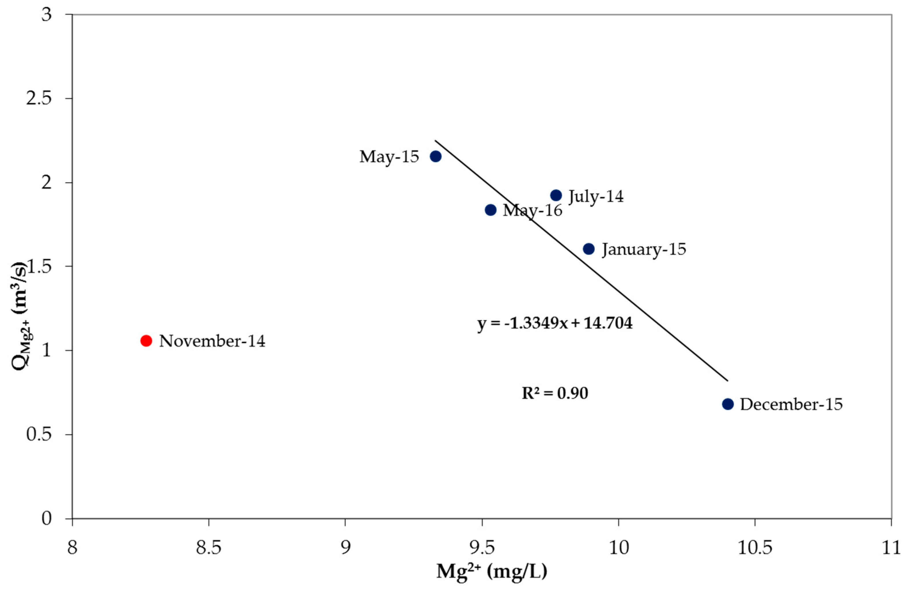
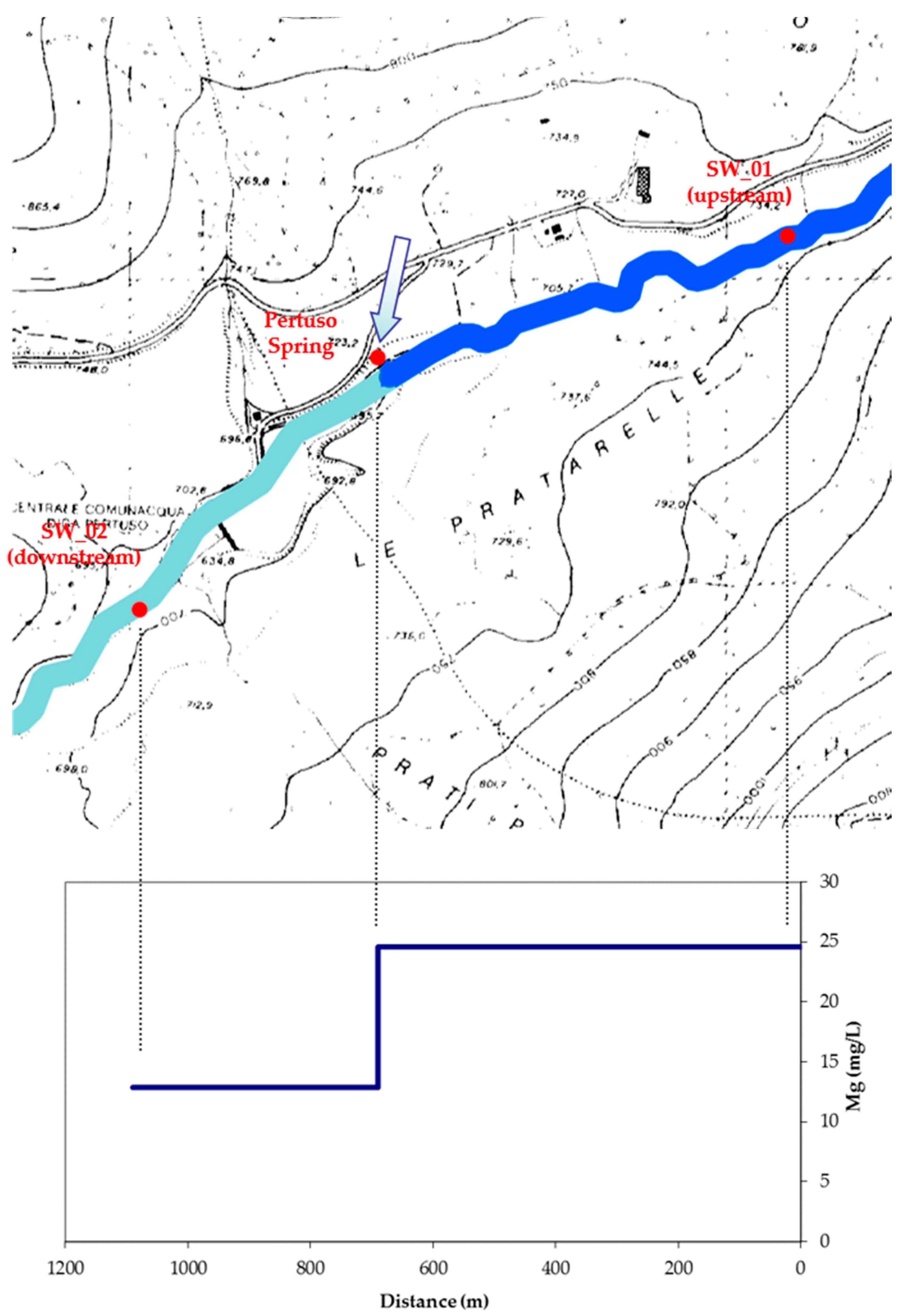
4.2. Discharge Experimental and Model Results

The Aniene River discharge was measured during the period July 2014–May 2016, in order to cover the range of seasonal condition characteristics of this complex hydrogeological system. Measurements by current-meter have been carried out in two gauging stations located upstream (SW_01) and downstream (SW_02) the Pertuso Spring (Table 2).
Table 2 shows discharge values recorded in SW_01 and SW_02 gauging stations all over the hydrological year. The source of Mg2+ concentration values in the Aniene River upstream the Pertuso Spring (SW_01) is the dissolution of magnesium-rich minerals in Triassic dolomites, sited in the northeast part of the Pertuso Spring basin. Along the Aniene River, this decrease in Mg2+ concentration values is related to an increase in stream flow discharge. SW_02 surface water is the product of the confluence of groundwater coming from the Pertuso Spring into the Aniene River (SW_01). As a matter of fact, the Aniene River, which is characterized by water with higher magnesium concentration values, is affected in its chemical composition by the Pertuso Spring groundwater inflowing, and this influence can be measured by variability in Mg2+ concentration values along the river downstream. The karst aquifer system has been studied in order to evaluate factors which modify the Aniene River flow due to groundwater–surface water interactions.
The n parameter (i.e., the percentage of the Pertuso Spring groundwater contribution to total discharge measured at the SW_02) has been calculated according to Equation (4) and reported in Table 3.
Table 4 summarizes the values of discharges evaluated. In particular, this table presents values of the Pertuso Spring discharge obtained by the difference between the values measured with the current-meter in SW_01 and SW_02 and the Pertuso Spring discharge obtained by magnesium tracer method. It is easy to see how discharge values obtained with both methods are very similar.

5. Discussion

The results of hydrogeochemical analysis and current discharge measurements confirm the groundwater–surface water mixing due to the presence of the Pertuso Spring, highlighting the key role of Mg2+ content to identify different feeding areas, depending on different water–rock interaction processes, and water flow paths within this karst setting.
Several previous studies used different conservative solute tracers to evaluate quantification of discharge in stream confluences starting from chemical mass balance techniques [15,16,17].
In this work, assessing the conservative behavior of Mg2+ for this specific system, it was possible to propose an inverse model for the Pertuso Spring discharge evaluation based only on Mg2+ concentration data.
The dilution mechanism, due to the groundwater and surface water interaction at the Pertuso confluence point, is the only mechanism responsible of the Mg2+ concentration change along the Aniene River (Figure 8).
The box plot graphically highlights the main characteristics of Mg2+ content (Figure 9) for the utilization in the chemical mass balance technique, whereas Ca2+ does not show the same adaptability (Figure 10). The two main characteristics are:
-
the concentration difference between the two inflows must be significant;
-
the concentration difference between the two inflows also must be greater than the uncertainty in the concentration data.
As a matter of fact, different from Ca2+, Mg2+ concentration data shows a very low variability in each sampling point and a high difference between the Pertuso Spring and SW_01, due to the water transit in different geological formations (calcareous and dolomitic rocks).
These properties lead to the correct evaluation of the “n” parameter in the mass balance and, consequently, to valid discharge results for the Pertuso Spring, confirmed by the comparison with conventional current-meter discharge values (Table 4).
The low variability of Mg2+ concentration in water samples is due to the slower process of dissolution for dolomitic rocks within the karst aquifer, resulting in a best discharge evaluation factor in base-flow conditions. On the contrary, during a storm, rainwater inflow and transit in karst conduits is too much rapid and does not allow the same dissolution process.
Hence, in this karst setting, Mg2+ emerges as a suitable conservative tracer only for main storage groundwater—which, however, is the most important for catchment works—involving springs. As a matter of fact, this is the part of the annual spring volume discharge, which is actually reliable for exploitation. This is especially so in karst aquifers, where there is a meaningful part of this volume, though it is discharged too quickly to be caught with effectiveness.
As a consequence, the Mg2+ vs Q scatterplot diagram (Figure 11) shows that all plotted points, except for November 2014 data, follow a linear trend, highlighting that the increasing base-flow contribution of the Pertuso Spring discharge rate is responsible of the decrease in Mg2+ concentration values. This is possible because data referred to the November 2014 monitoring campaign have to be considered as an outlier (Figure 11). In fact, the lower Mg2+ concentration measured in November 2014 can be related to a high precipitation rate, recorded at Trevi nel Lazio meteorological station, during five days before the sampling date. As previously said, the consequent aquifer rapid response probably influenced, by dilution, the Mg2+ concentration in groundwater that was no more significant for the conceptual model.
Futures discharge and Mg2+ concentration data will be helpful for the model validation, confirming the linear trend obtained for previous data.

6. Conclusions

This paper dealt with the assessment of the interactions between a karst aquifer feeding the Pertuso Spring and the Aniene River surface waters on the basis of stream discharge measurements and water geochemical tracers data with the aim to set up an inverse model, which allows estimation of groundwater flow coming out from the Pertuso Spring, starting from surface water discharge measurements and geochemical water characterization. These results, obtained in the area under study (sited in the karst aquifer outcropping in the Upper Valley of the Aniene River) show that it is possible to have a reliable evaluation of the Pertuso Spring discharge through the elaboration of surface water discharge measurements and Mg2+ concentration values, determined for groundwater, coming from the Pertuso Spring, and for both surface water samples: those collected upstream and downstream the Pertuso Spring, along the Aniene River. Although it is subject to some uncertainties, the Mg2+ concentration, as an environmental tracer, provides an indirect method for discharge evaluation of the Pertuso Spring, due to the mixing of surface water and groundwater, and provides information on changes in water quantity and quality.

Acknowledgments

The research reported in this paper was supported by the Department of Civil, Building and Environmental Engineering (DICEA) of Sapienza University of Rome. The authors gratefully acknowledge the technical support of ACEA ATO2.

Author Contributions

For this research article all of the authors contributed extensively to the work. Giuseppe Sappa led this research, Francesco Maria De Filippi performed the field work, Flavia Ferranti developed the GIS analysis and compiled the figures, Giulia Cardillo participated in drafting the article and helped in manuscript correction. All the authors contributed to data analysis and to the manuscript writing.

Conflicts of Interest

The authors declare no conflict of interest.

References

  1. Cozma, A.I.; Baciu, C.; Moldovan, M.; Pop, I.C. Using natural tracers to track the groundwater flow in a mining area. Procedia Environ. Sci. 2016, 32, 211–220. [Google Scholar] [CrossRef]
  2. Guo, Q.; Wang, Y.; Ma, T.; Li, L. Variation of karst springs discharge in recent five decades as an indicator of global climate change: A case study at Shanxi, northern China. Sci. China Ser. D Earth Sci. 2005, 48, 2001–2010. [Google Scholar] [CrossRef]
  3. Sappa, G.; Luciani, G. Groundwater management in Dar Es Salam Coastal Aquifer (Tanzania) under a difficult sustainable development. WSEAS Trans. Environ. Dev. 2014, 10, 465–477. [Google Scholar]
  4. Sappa, G.; Ferranti, F.; Ergul, S.; Ioanni, G. Evaluation of the groundwater active recharge trend in the coastal plain of Dar Es Salaam (Tanzania). J. Chem. Pharm. Res. 2013, 5, 548–552. [Google Scholar]
  5. Foster, S.; Hirata, R.; Andreo, B. The aquifer pollution vulnerability concept: Aid or impediment in promoting groundwater protection? Hydrogeol. J. 2013, 21, 1389–1392. [Google Scholar] [CrossRef]
  6. Bakalowicz, M. Karst groundwater: A challenge for new resources. Hydrogeol. J. 2005, 13, 148–160. [Google Scholar] [CrossRef]
  7. Cowie, R.; Williams, M.W.; Wireman, M.; Runkel, R.L. Use of natural and applied tracers to guide targeted remediation efforts in an acid mine drainage system, Colorado Rockies, USA. Water 2014, 6, 745–777. [Google Scholar] [CrossRef]
  8. Pitty, A.F. The estimation of discharge from a karst rising by natural salt dilution. J. Hydrol. 1966, 4, 63–69. [Google Scholar] [CrossRef]
  9. White, W.B. Conceptual models for carbonate aquifers. Ground Water 1969, 7, 15–22. [Google Scholar] [CrossRef]
  10. Quinlan, J.F.; Ewers, R.O. Subsurface drainage in the Mammoth Cave area. In Karst Hydrology Concepts from the Mammoth Cave Area: New York, Van Nostrand Reinhold; White, W.B., White, E.L., Eds.; Springer: New York, NY, USA, 1989; pp. 65–104. [Google Scholar]
  11. White, W.B. Karst hydrology: Recent developments and open questions. Eng. Geol. 2002, 65, 85–105. [Google Scholar] [CrossRef]
  12. Sappa, G.; Ferranti, F.; de Filippi, F.M. Preliminary validation of an indirect method for discharge evaluation of Pertuso Spring (Central Italy). WSEAS Trans. Environ. Dev. 2016, 12, 214–225. [Google Scholar]
  13. Lauber, U.; Goldscheider, N. Use of artificial and natural tracers to assess groundwater transit-time distribution and flow systems in a high-alpine karst system (Wetterstein Mountains, Germany). Hydrogeol. J. 2014, 22, 1807–1824. [Google Scholar] [CrossRef]
  14. Ergul, S.; Ferranti, F.; Sappa, G. Arsenic in the aquifer systems of Viterbo Region, Central Italy: Distribution and Geochemistry. Rend. Online Soc. Geol. Ital. Soc. Geol. Ital. Roma 2013, 24, 116–118. [Google Scholar]
  15. Alvarado, J.A.C.; Purtschert, R.; Barbecot, F.; Chabault, C.; Ruedi, J.; Schneider, V.; Aeschbach-Hertig, W.; Kipfer, R.; Loosli, H.H. Constraining the age distribution of highly mixed groundwater using 39Ar: A multiple environmental tracer (3H/3He, 85Kr, 39Ar and 14C) study in the semiconfined Fontainebleau Sands Aquifer (France). Water Resour. Res. 2007, 43, 1–16. [Google Scholar]
  16. Troldborg, L.; Jensen, K.H.; Engesgaard, P.; Refsgaard, J.C.; Hinsby, K. Using environmental tracers in modeling flow in a complex shallow aquifer system. J. Hydrol. Eng. 2008, 13, 1037–1084. [Google Scholar] [CrossRef]
  17. Lavastre, V.; La Salle, C.; Michelot, J.; Giannesini, S.; Benedetti, L.; Lancelot, J.; Lavielle, B.; Massault, M.; Thomas, B.; Gilabert, E.; et al. Establishing constraints on groundwater ages with 36Cl, 14C, 3H, and noble gases: A case study in the eastern Paris Basin, France. Appl. Geochem. 2010, 25, 123–142. [Google Scholar] [CrossRef]
  18. Caschetto, M.; Barbieri, M.; Galassi, D.M.P.; Mastrorillo, L.; Rusi, S.; Stoch, F.; Di Cioccio, A.; Petitta, M. Human alteration of groundwater-surface water interactions (Sagittario River, Central Italy): Implication for flow regime, contaminant fate and invertebrate response. Environ. Earth Sci. 2014, 71, 1791–1807. [Google Scholar] [CrossRef]
  19. Kincaid-Vice, T.R. Groundwater tracing in the Woodville karst plain—Part I: An overview of groundwater tracing. DIR Quest J. Glob. Underw. Explor. 2003, 4, 31–37. [Google Scholar]
  20. Aquilanti, L.; Clementi, F.; Nanni, T.; Palpacelli, S.; Tazioli, A.; Vivalda, P. DNA and fluorescein tracer tests to study the recharge, groundwater flowpath and hydraulic contact of aquifers in the Umbria-Marche limestone ridge (Central Apennines, Italy). Environ. Earth Sci. 2016, 75, 626. [Google Scholar] [CrossRef]
  21. Cervi, F.; Corsini, A.; Doveri, M.; Mussi, M.; Ronchetti, F.; Tazioli, A. Characterizing the recharge of fractured aquifers: A case study in a flysch rock mass of the northern Apennines (Italy). In Engineering Geology for Society and Territory; Lollino, G., Arattano, M., Rinaldi, M., Giustolisi, O., Marechal, J.C., Grant, G.E., Eds.; Springer: Cham, Switzerland, 2014; Volume 3, pp. 563–567. [Google Scholar]
  22. Sappa, G.; Ergul, S.; Ferranti, F. Geochemical modeling and multivariate statistical evaluation of trace elements in arsenic contaminated groundwater systems of Viterbo Area, (Central Italy). Springerplus 2014, 3, 1–19. [Google Scholar] [CrossRef] [PubMed]
  23. Cook, P.G.; Favreau, G.; Dighton, J.C.; Tickell, S. Determining natural groundwater influx to a tropical river using radon, chlorofluorocarbons and ionic environmental tracers. J. Hydrol. 2003, 277, 74–88. [Google Scholar] [CrossRef]
  24. Davis, S.D.; Thompson, G.M.; Bentley, H.W.; Stiles, G. Ground-water tracers—A short review. Groundwater 1980, 18, 14–23. [Google Scholar] [CrossRef]
  25. Sappa, G.; Ferranti, F.; de Filippi, F.M. A proposal of conceptual model for the Pertuso Spring discharge evaluation in the Upper Valley of Aniene River. Acque Sotter. 2016, 5, 3. [Google Scholar] [CrossRef]
  26. Stauffer, R.E. Use of solute tracers released by weathering to estimate groundwater inflow to Seepage Lakes. Environ. Sci. Technol. 1985, 19, 405–411. [Google Scholar] [CrossRef] [PubMed]
  27. Herman, J.S.; White, W.B. Dissolution kinetics of dolomite: Effects of lithology and fluid flow velocity. Geochim. Cosmochim. Acta 1985, 49, 2017–2026. [Google Scholar] [CrossRef]
  28. Bencala, K.E.; McKnight, D.M.; Zellweger, G.W. Evaluation of natural tracers in an acidic and metal-rich stream. Water Resour. Res. 1987, 23, 827–836. [Google Scholar] [CrossRef]
  29. Schemel, L.E.; Cox, M.H.; Runkel, R.L.; Kimball, B.A. Multiple injected and natural conservative tracers quantify mixing in a stream confluence affected by acid mine drainage near Silverton, Colorado. Hydrol. Process. 2006, 20, 2727–2743. [Google Scholar] [CrossRef]
  30. Montanari, A.; Staniscia, B. An overview of territorial resources and their users in the Rome and Chieti-Pescara Areas. In Sustainability in the Coastal Urban Environment: Thematic Profiles of Resources and Their Users; Khan, A.Z., Quynh, L.X., Corijn, E., Canters, F., Eds.; Sapienza Università Editrice: Rome, Italy, 2012; Volume 3, pp. 61–109. [Google Scholar]
  31. Sappa, G.; Ferranti, F.; de Filippi, F.M. Environmental tracer approach to discharge evaluation of Pertuso Spring (Italy). In Recent Advances on Energy and Environment, Proceedings of the 10th International Conference on Energy & Environment, Budapest, Hungary, 12–14 December 2015; Bulucea, A., Ed.; World Scientific and Engineering Academy and Society (WSEAS): Budapest, Hungary, 2015; pp. 54–62. [Google Scholar]
  32. Ventriglia, U. Idrogeologia II parte. In Idrogeologia Della Provincia di Roma, IV, Regione Orientale; Amministrazione Provinciale di Roma, Assessorato LL.PP, Viabilità e Trasporti: Roma, Italy, 1990. [Google Scholar]
  33. Bono, P.; Percopo, C. Flow dynamics and erosion rate of a representative Karst Basin (Upper Aniene River, Central Italy). Environ. Geol. 1996, 27, 210–218. [Google Scholar] [CrossRef]
  34. De Felice, A.M.; Dragoni, W.; Giglio, G. Methods of Hydrological Basin Comparison; Report No. 120; Institute of Hydrology: Roorkee, India, 1992. [Google Scholar]
  35. Accordi, G.; Carbone, F. Carta Delle Litofacies del Lazio-Abruzzo ed Aree Limitrofe; Consiglio Nazionale Delle Ricerche: Roma, Italy, 1988. [Google Scholar]
  36. Bosellini, A. La Storia Geologica Delle Dolomiti; Dolomiti: Trento, Italy, 1989. [Google Scholar]
  37. Damiani, A.V. Studi sulla piattaforma carbonatica laziale-abruzzese. Nota I. Considerazioni e problematiche sull’assetto tettonico e sulla paleogeologia dei Monti Simbruini. Studies on the Lazio-Abruzzi carbonate platform. Note XI. Considerations and problems on tectonic and paleogeologic Simbruini Mts. In Memorie Descrittive Carta Geologica d’Italia; Istituto Superiore per la Protezione e la Ricerca Ambientale: Rome, Italy, 1990; Volume 38, pp. 177–206. [Google Scholar]
  38. Sappa, G.; Ferranti, F. An integrated approach to the Environmental Monitoring Plan of the Pertuso Spring (Upper Valley of Aniene River). Ital. J. Groundw. 2014, 3, 47–55. [Google Scholar]
  39. Sappa, G.; Ergul, S.; Ferranti, F. Vulnerability assessment of Mazzoccolo Spring Aquifer (Central Italy), combined with geo-chemical and isotope modeling. Eng. Geol. Soc. Territ. 2015, 5, 1387–1392. [Google Scholar]
  40. Sappa, G.; Ergul, S.; Ferranti, F.; Sweya, L.N.; Luciani, G. Effects of seasonal change and seawater intrusion on water quality for drinking and irrigation purposes, in coastal aquifers of Dar es Salaam, Tanzania. J. Afr. Earth Sci. 2015, 105, 64–84. [Google Scholar] [CrossRef]
  41. Acea Ato 2 S.p.A. Studio Idrogeologico—Proposta di Aree di Salvaguardia Della Sorgente del Pertuso “Hydrogeological Study—Proposal for Protected Areas of Pertuso Spring”. Unpublished work. 2005. [Google Scholar]
  42. United States Environmental Protection Agency (US EPA) Region 6. Standard Operating Procedure for Stream Flow Measurement; US EPA: Washington, DC, USA, 2003.
  43. British, European and International Standards. BS EN ISO 748:2007 Hydrometry—Measurement of Liquid Flow in Open Channels Using Current-Meters or Floats; International Organization for Standardization (ISO): Geneva, Switzerland, 2007. [Google Scholar]
  44. Tazioli, A. Experimental methods for river discharge measurements: Comparison among tracers and current meter. Hydrol. Sci. J. 2011, 56, 1314–1324. [Google Scholar] [CrossRef]
  45. Piper, M. A graphic procedure in the geochemical interpretation of water-analyses. Trans. Am. Geophys. Union 1944, 25, 914–923. [Google Scholar] [CrossRef]
  46. Edmunds, W.M.; Cook, J.M.; Darling, W.G.; Kinniburgh, D.G.; Miles, D.L.; Bath, A.H.; Morgan-Jones, M.; Andrews, J.N. Baseline geochemical conditions in the Chalk aquifer, Berkshire, UK: A basis for groundwater quality management. Appl. Geochem. 1987, 2, 251–274. [Google Scholar] [CrossRef]
Figure 1. Simplified geological map of the Pertuso Spring hydrogeological basin and location of the Aniene River gauging sections.
Water 09 00067 g001
Figure 2. Geological cross-section of the Pertuso Spring.
Water 09 00067 g002
Figure 3. Section SW_01 set up at the May 2015 (a) and December 2015 (b) measurement campaigns.
Water 09 00067 g003
Figure 4. Piper plot for hydrochemical facies classification of groundwater and surface water.
Water 09 00067 g004
Figure 5. Ternary diagram of cations Ca2+, Mg2+, and Na+ + K+. Relative concentrations of dissolved major cations compared with the composition of local groundwater [41].
Water 09 00067 g005
Figure 6. Feeding areas of the main karst springs in the Upper Valley of the Aniene River.
Water 09 00067 g006
Figure 7. Mg2+/Ca2+ ratio versus HCO3 in groundwater and surface water.
Water 09 00067 g007
Figure 8. Schematic dilution mechanism in Mg2+ concentration along Aniene River.
Water 09 00067 g008
Figure 9. Box plot of mean, median, maximum, and minimum values of magnesium distribution.
Water 09 00067 g009
Figure 10. Box plot of mean, median, maximum, and minimum values of calcium distribution.
Water 09 00067 g010
Figure 11. Relationship between the Mg2+ concentration and the Pertuso Spring discharge values obtained with the combined magnesium-discharge tracer approach.
Water 09 00067 g011
Table 1. Summary statistics for in situ measurements of physicalochemical parameters and chemical concentrations of constituents of water samples.
ParametersSW_01Pertuso SpringSW_02
MinMaxMeanMinMaxMeanMinMaxMean
Ca2+ (mg/L)53.457.855.348.953.351.251.355.653.0
Mg2+ (mg/L)23.625.224.68.310.49.512.014.712.9
Na+ (mg/L)2.32.62.41.82.11.90.42.21.7
K+ (mg/L)0.40.50.40.30.50.40.32.30.8
HCO3 (mg/L)0.4302.6292.0206.0238.0221.8218.4235.5226.3
SO42− (mg/L)2.93.23.02.32.52.42.52.72.6
Cl (mg/L)3.84.54.23.23.73.43.34.23.7
NO3 (mg/L)0.85.71.90.91.21.00.91.11.0
T (°C)5.811.38.68.09.58.56.710.78.3
pH8.08.58.47.88.07.98.18.28.2
EC (μS/cm)356.0399.0386.8283.0291.0287.7294.0317.0311.2
Hardness (°F)23.124.823.916.117.416.717.919.318.6
Table 2. Mean discharge values obtained by current-meter method, upstream (SW_01) and downstream (SW_02) the Pertuso Spring.
Q (m3/s)SW_01SW_02
July 20140.5402.450
November 20140.3501.480
January 20150.4101.920
May 20150.5012.747
December 20150.2780.931
May 20160.4302.305
Table 3. Values of n as percentage contribution of the Pertuso Spring groundwater to total discharge measured at the SW_02 gauging station.
Datenn (%)
July 20140.78078.0
November 20140.75275.2
January 20150.79479.4
May 20150.81281.2
December 20150.70970.9
May 20160.81081.0
Table 4. Magnesium content and discharge values obtained by current-meter and magnesium tracer method (Q *: discharge values obtained by current-meter method; Q **: discharge values obtained by the difference between the values measured with the current-meter in SW_01 and SW_02).
DateSW_01Pertuso SpringSW_02
Q *Mg2+Q **QMgMg2+Q *QMgMg2+
(m3/s)(meq/L)(m3/s)(m3/s)(meq/L)(m3/s)(m3/s)(meq/L)
July 20140.541.941.911.920.802.452.461.05
November 20140.351.931.131.060.681.481.410.99
January 20150.412.071.511.580.811.921.991.07
May 20150.502.022.232.160.772.752.661.00
December 20150.282.070.670.680.860.930.961.21
May 20160.432.071.871.840.782.302.291.03

