Seasonal Water Exchanges between China’s Poyang Lake and Its Saucer-Shaped Depressions on River Deltas


Key Laboratory of Watershed Geographic Sciences, Nanjing Institute of Geography and Limnology, Chinese Academy of Sciences, Nanjing 21008, China
*
Author to whom correspondence should be addressed.
Water 2017, 9(11), 884; https://doi.org/10.3390/w9110884
Submission received: 11 October 2017
/
Revised: 9 November 2017
/
Accepted: 10 November 2017
/
Published: 12 November 2017
(This article belongs to the Special Issue Recent Progress in Research on River Deltas)
Abstract
:The saucer-shaped depressions located at the river deltas of Poyang Lake are typical floodplain shallow sub-lakes subject to river-lake connection or isolation. The hydrological connectivity between these depressions and the main lake has a major influence on the hydrologic function and ecological integrity of the lake-floodplain and associated wetland habitats. This study explored the water level fluctuations and water exchange processes between the Poyang Lake and three typical saucer-shaped depressions, using a 30-min temporal resolution of water level observations during 2015–2016. Our results showed that the water level correlation and hydrological connectivity between the main lake and its depressions displayed a strong seasonal and spatial signal. Temporally, the rainfall significantly influences the seasonality and frequency of water level fluctuations both in the main lake and the depressions. The correlation coefficient of the water level ordered from high to low occurred during the high-water period, the rising-water period, the falling-water period and the low-water period, respectively. Spatially, depressions with a shorter connection duration to the main lake are located at higher local elevation and at larger geographical distance from the main lake. Finally, we also discussed the implications of these findings and possible factors that could have caused these particular water regime characteristics and water exchange processes.
1. Introduction
Wetlands are the most biologically productive and ecologically diverse terrestrial ecosystems on earth [1,2]. They perform a variety of important ecosystem functions, such as flood mitigation, exerting control over nutrient and biogeochemical cycles, and providing habitat for freshwater aquatic plants and animals [3,4]. For shallow lake-wetlands in the world, many topographic depressions are generally distributed on low-relief river delta regions [5,6]. Under these conditions, water level fluctuations of wetlands are largely modulated by hydrological connectivity and water exchanges between the depressions and a main lake, which as a decisive factor of the water regime may have an overriding effect on ecosystem functions [7,8,9]. The analysis of these connectivity mechanisms is recognized as a key step to inform delta management plans and hydrologic prediction. For example, wetland restoration efforts require quantitative knowledge of hydrological connectivity in delta systems [10]. Moreover, in shallow lake-wetlands, the rate, duration and magnitude of water exchange between depressions and the adjacent main lake also have major influences on the water quality, aquatic habitat, organic matter and organisms, since movement of chemical constituents and biota are often associated with water flow [11,12,13]. Therefore, hydrological connectivity and water exchange are especially important considerations for shallow lake-wetlands [14,15]. A better understanding of these hydrologic processes is critical to helping regulate wetland structure and assess the status of vulnerable delta systems [1,16,17].
Poyang Lake is the largest shallow freshwater lake in China. It is recognized as an important lake wetland of extraordinary biological diversity with abundant and diverse populations of migratory birds, invertebrate species and aquatic plants [18,19]. Poyang Lake has a sub-tropical climate with an alternation of dry and wet periods, and the water surface area of the entire lake shows significant seasonal variations [20,21]. Generally, the lake expands to a large water surface area in the wet season (April to September). However, the large water surface becomes separated during the dry season (October to March), forming a large wetland with many independent depressions (sub-lakes), natural levees and floodplains [22] (Figure 1). These depressions can occur in the landscape where a low-lying area collects and stores water in a shallow, saucer-shaped feature, and they provide feeding and living places for approximately 80% of the winter waterfowl in the Poyang Lake area. They are especially important for the maintenance of the integrity and biodiversity of the Poyang Lake wetland ecosystem [23]. The functionality of these saucer-shaped depressions has been well-established and is dependent on regular hydrologic recharge mainly through precipitation and surface water processes [23,24]. However, much of our knowledge on the mechanisms behind such recharge and the surface water exchange processes remains limited. In particular, the response to lake inundation of water level fluctuations in different saucer-shaped depressions is poorly understood due to the complexity of the flow patterns and the limited number of in situ observations across the wetland, making it difficult to comprehensively inform the decision-making process of hydro-ecological management in the Poyang Lake wetland.
Given this background, the main objective of the present study is to examine water exchange processes and the water level relationship between saucer-shaped depressions and Poyang Lake. We evaluate how water level fluctuations in different saucer-shaped depressions along the downstream direction are related to the water level regime in the main lake. To address this objective, we combine high resolution water level data and meteorological observations, as well as quantitative indices, to compare flow regimes and hydrological connectivity changes and to gain a better understanding of how connected streams and depressions interact. In a broader context, our findings should be valuable for hydrological safety and biodiversity conservation as well as information for the preparation and precautions against extreme hydrological events.
2. Data and Methods
2.1. Study Area
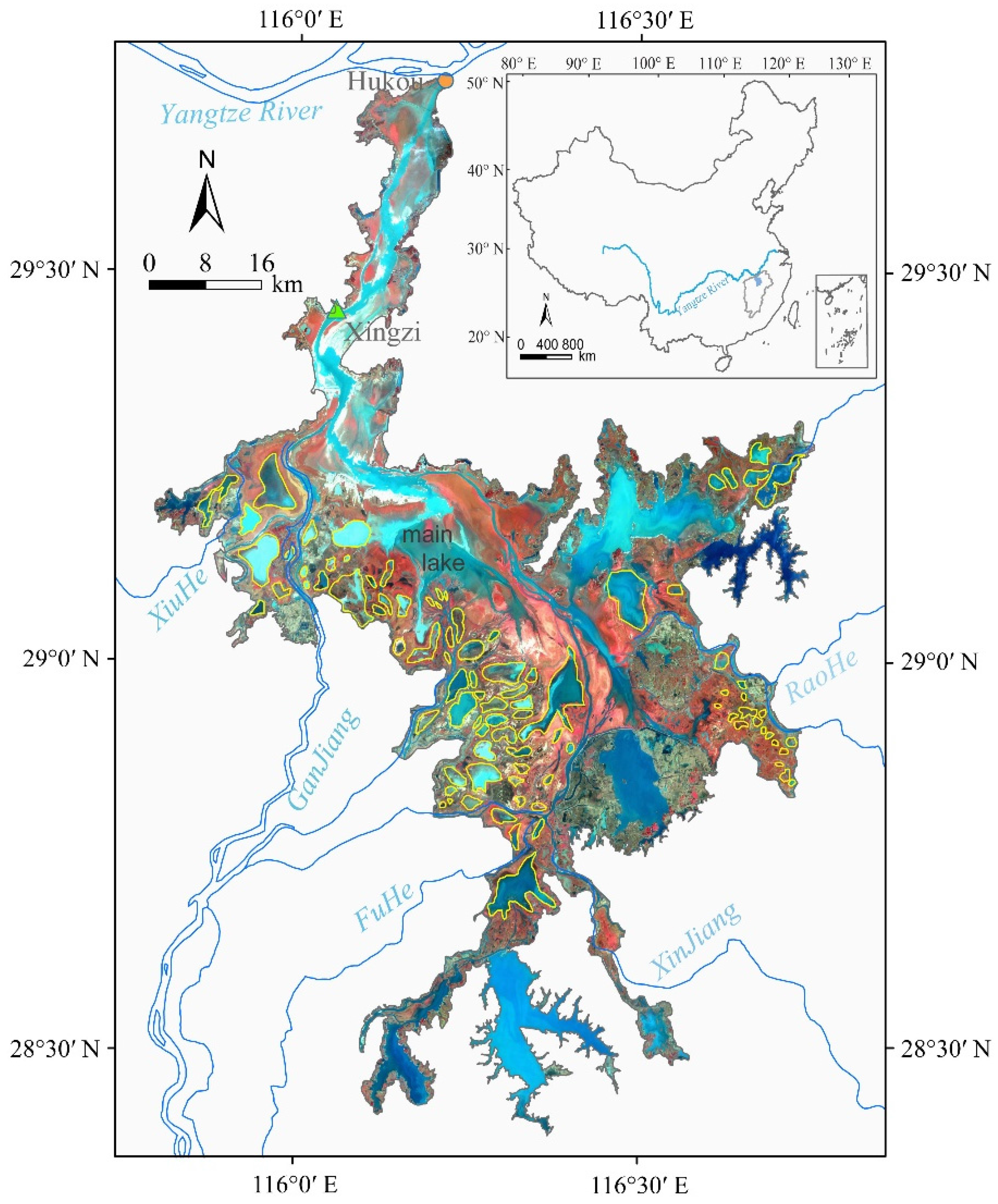
Poyang Lake (28°22′–29°45′ N, 115°47′–116°45′ E) is located in the middle reach of the Yangtze River basin, Jiangxi Province, China. As shown in Figure 1, Poyang Lake receives water that flows primarily from five rivers, XiuHe, GanJiang, FuHe, XinJiang and RaoHe, and discharges into the Yangtze River via Hukou (Figure 1). Due to the subtropical monsoon climate, its water surface exhibits considerable seasonal variability, where water coverage at the highest summer flood stage can exceed 3000 km2, while in winter it reduces to less than 1000 km2 [25], exposing mudflats, dikes, channels and shallow depressions (marked by yellow outlines in Figure 1) [21,22]. According to the available data, there are nearly 100 shallow depressions located at the river delta of Poyang Lake (Figure 1), with a total area of approximately 800 km2 [23]. All of these shallow depressions have a saucer-shaped profile, and a maximum water depth that is usually less than 2 m. They provide important habitat for the winter waterfowl in local nature reserves [23]. Depending on the expansion or contraction of the water surface, these shallow depressions are seasonally connected with the main lake when water levels are high, but become disconnected when water levels are low, and the wetland ecosystem depends largely upon regular hydrologic interaction between the depressions and the main lake [26].
In the present study, three typical saucer-shaped depressions, the Bang-Hu, Dong-Hu and Jinxi-Hu, were selected as study sites. These depressions are similar in size and located in the mouth zones of the XiuHe, Ganjiang and FuHe rivers, respectively, from north to south (Figure 2). The three saucer-shaped depressions present distinct morphometric characteristics and degrees of association with the main Lake. The geographical, hydrological and physical features of the selected depressions are presented in Table 1, and their locations are shown in Figure 2.
2.2. Data Acquisition and Analysis Methods
A number of gauging stations are available to monitor water levels of the main lake. In this study, the water level gauging station of Xingzi (indicated by the green triangle in Figure 1), located in the central part of Poyang Lake and approximately 38.5 km from the Hukou, is used to represent the hydrological regime of the main lake body [9]. Daily water level data for the Xingzi station were obtained from the hydrological Bureau of the Jiangxi Province from 2015–2016. In addition, to obtain the water level records of each selected saucer-shaped depression, three Solinst® 3001 Levelogger pressure transducers (Solinst, Georgetown, ON, Canada) were installed in the lake bed of the depressions (Figure 2A). This Levelogger is basically a hydrostatic sensor that is able to provide accurate water level readings (accuracy: ±10 mm) by compensating for barometric pressure. The transducers were secured with a steel fence post, with the steel cable running along the lake bed in a PVC (polyvinyl chloride) pipe (Figure 2B). In this study, the water level data of each depression were continuously recorded at 30-min intervals for nearly 2 years from 8 February 2015 to 3 November 2016. These half-hourly data were then averaged to daily means for each day.
In addition to these water level records, we used the following datasets: (1) daily discharge data (during 2015–2016) from five gauging stations (Wanjiabu, Waizhou, Lijiadu, Meigang, and Shizhenjie) in the five main tributaries were obtained from the Hydrological Bureau of the Yangtze River Water Resources Commission of China. The geographical distribution of these stations and their attributes are also shown in Table 1; (2) daily precipitation data over the Poyang Lake catchment, covering a time period from 2015 to 2016, were made available by the National Climatic Centre of the Chinese Meteorological Administration; and (3) the latest digitized topographic map of the floodplain (scale 1:10,000, Hydrological Bureau of Jiangxi Province, China, 2011) was used in combination with a series of Moderate Resolution Imaging Spectrometer (MODIS) near-infrared satellite images (acquired from 2015–2016) to identify all depressions, streams and lakes and to determine relative differences in elevation within the floodplain. The MODIS images were acquired from the NASA Goddard Space Flight Center (GSFC) (http://ladsweb.nascom.nasa.gov). To evaluate the degree of hydrological connectivity between saucer-shaped depressions and the main lake of Poyang, we introduced several hydrologic connectivity indices in this study. These indices primarily depend on the water level of the depressions relative to main lake height, including duration of connectivity (days) and stage range (m), as well as the average coefficients of determination (R2) for linear equations to quantify the relationship between depressions and the main lake [27,28]. The degree of connectivity was then classified into two categories, based on the duration of water connection derived from the series of water level records [29]: (1) Connection: depressions and main lake connected with the water level larger than main lake. (2) Isolation: depressions that are not connected to the main lake. For all study sites, data from the water level loggers are relative; therefore, water level changes were first calibrated to absolute water surface elevation values using differential GPS-based surveys with accuracy of ±1 to 5 cm (referenced to the Wusong Elevation System), enabling absolute referencing of water level data across the study area.
3. Results
3.1. Water Level Fluctuations
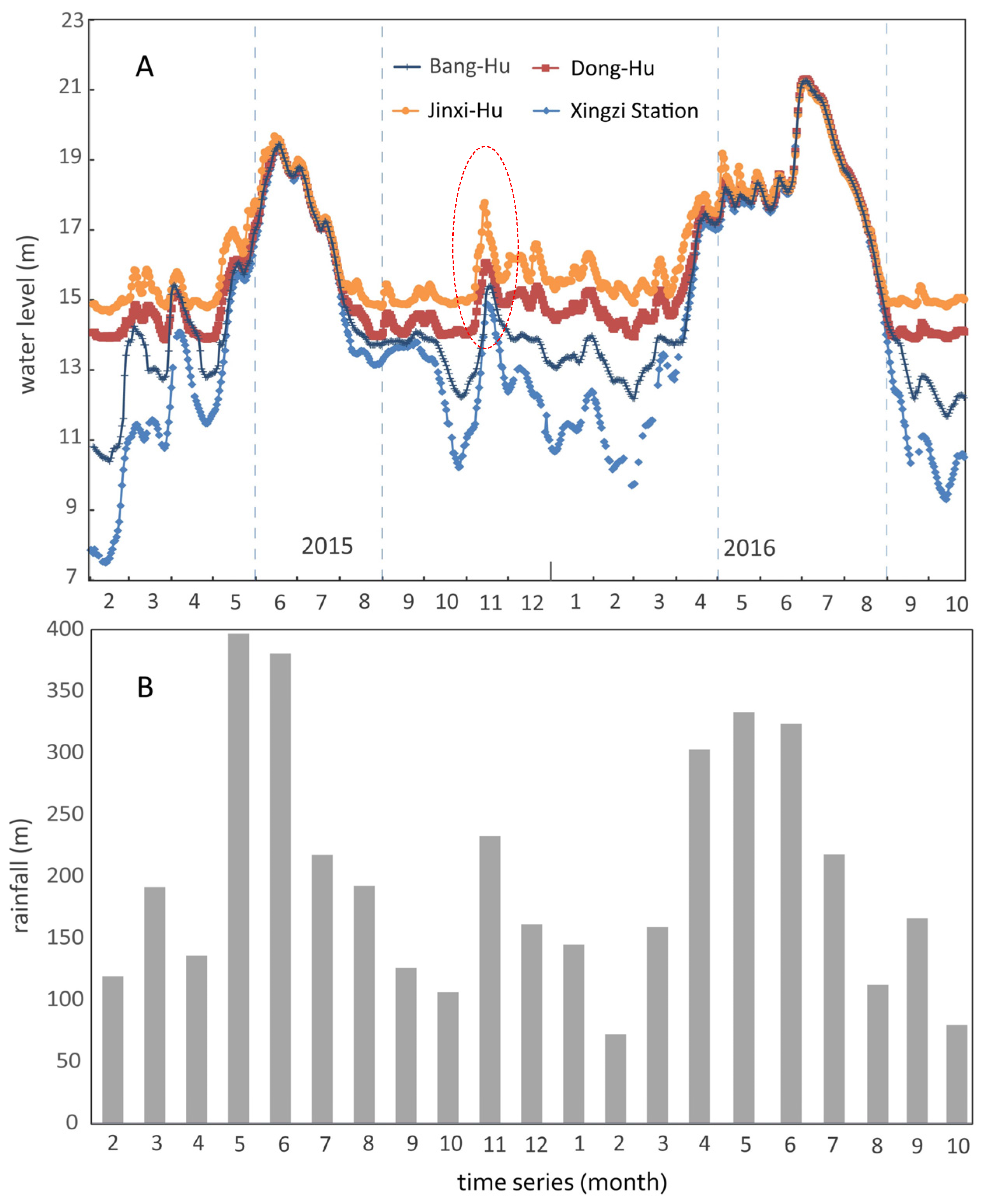
Figure 3 shows the water level fluctuation of saucer-shaped depressions and Xingzi hydrologic station of Poyang Lake from February 2015 to November 2016, showing clear seasonal and inter-annual variations. The mean water level fluctuation of the depressions is approximately 7–8 m. In both 2015 and 2016, the saucer-shaped depressions share similar hydrological characteristics with the main lake (Figure 3). They both have high fluctuations of water levels annually, with the depressions appearing in the dry season (November–January), as opposed to the whole lake in the wet season (May–July). According to Figure 3, the relationships between saucer-shaped depressions and the main lake of Poyang throughout the hydrologic regime can be categorized into four phases: (1) the rising-water period (March–May), due to the increased water inflow of the five rivers into the main lake until the water stage reaches the top of the natural levee; (2) the high-water period (June–August), when the main lake water overflows the natural levee in the onset of this phase, mixing with the depression water and incorporating them into the main lake water; (3) the falling-water period (September–November), which starts when the water level falls below the bankfull level; and (4) the isolation period (December–February), indicating a lack of connection between the depressions and the main lake body, and the elevations of the depressions’ surfaces are far higher than the main lake. As we can see, the main lake precedes the depressions in both the rising and the decreasing stages of the water level. This suggests that, due to the effect of the bottom topography, the depressions are mainly supplied by the main lake. However, all fluctuation series present various peaks and valleys because of the different bottom elevation of each depression.
Furthermore, correlations between rainfall variables and water level response statistics were examined. As seen in Figure 3, the patterns of variation in rainfall and lake level were similar from 2015–2016, reflecting both long-term and short-term watershed response to rainfall. Generally, the water levels in the depressions had increased with the onset of rainfall events by late April, and this continued into June or July when large amounts of rainfall runoff passed through the channels. During the rainy period, when the water level in the main channel rises above the elevation of the natural levee, this reverses the hydraulic gradient and induces water flow from the main lake into the depressions. Therefore, as the rainfall increases, the water surface elevation of the depressions also progressively increases during the subsequent months. After the flood, rainfall declines gradually in the latter half of July, the depression levels drop proportionately and a lake-ward hydraulic gradient is again established. Then, the depressions are mainly separated from the adjacent main lake, and there is no exchange with the main lake, thus becoming important wetland habitats for migratory birds.
In addition, it is important to note that all depression levels varied almost negligibly during the low-water period. However, there was a significant precipitation anomaly in the Poyang Lake Basin during October–December in 2015. These rain events caused substantial, short-duration spikes in the water level of the depressions (Figure 3). This suggests that the depressions can be recharged measurably by large rain events. Actually, in natural environments, changes of precipitation patterns are expected to reflect on stream discharges [30]. It remains prominent to make realistic connections between precipitation patterns and water regimes at the watershed scale [31]. Therefore, the variability of depression level is mainly controlled by watershed-scale hydrologic alteration. Indeed, during the winter of 2015, there was a strong El Niño-Southern Oscillation (ENSO) event, resulting in significant precipitation anomaly in the Poyang Lake Basin [32]. The frequency of moderate-heavy precipitation increased significantly, with a maximum increase of 15–20% during the 2015-ENSO event. A period of high flows in November 2015 generated lateral connectivity between the depressions and the main lake.
3.2. Degrees of Hydrological Connectivity
These water level change processes reflect their hydrological connectivity to the main lake via distributary channels. The relative difference between lake levels and natural levee elevations may control flow rates and provide connection and isolation thresholds within the system. Table 2 depicts the water stage heights and durations of hydrological phases in the different saucer-shaped depressions during 2015–2016. Based on continuous water level records, we can identify two major phases of hydrological relationship between the depressions and the main lake: isolation and connection (Table 2). Clearly, the duration and magnitude of the isolation or connection phase varied greatly from depression to depression. During the isolation phase, the water level was higher in the depressions compared to the main lake. As the rainfall increased during the rising-water period of 2015, Bang-Hu was first connected with the main lake when the water level of the Xingzi station exceeded 14.05 m, while Dong-Hu and Jinxi-Hu were subsequently connected when the lake level reached 16.1 m and 17.5 m, respectively. However, during the falling-water period of 2015, JinXi-Hu was the first to be isolated from the main lake when it had dropped to 15.81 m, and Dong-Hu (15.15 m) and Bang-Hu (14.68 m) followed with a short time lag. In other words, the sequence of isolation is exactly opposite that of connection with the main lake. Furthermore, according to Table 2, Jinxi-Hu was isolated from the main lake for 485 days, i.e., 74% of the observation period (from 8 February 2015 to 3 November 2016). At the same time, the other depressions, Dong-Hu and Bang-Hu, were isolated from the main lake for fewer days (464 days and 423 days) for the study period. This result illustrates that the spatial distribution of connection duration of depressions shows a clear pattern (Table 2). In general, the connection duration slightly increases in the downstream direction, with decreasing water level in the main lake. This was ultimately controlled by the bottom topography and the distance to the main lake. Depressions with higher degrees of connectivity are located mostly in the northern part and at shorter distances to the main lake.
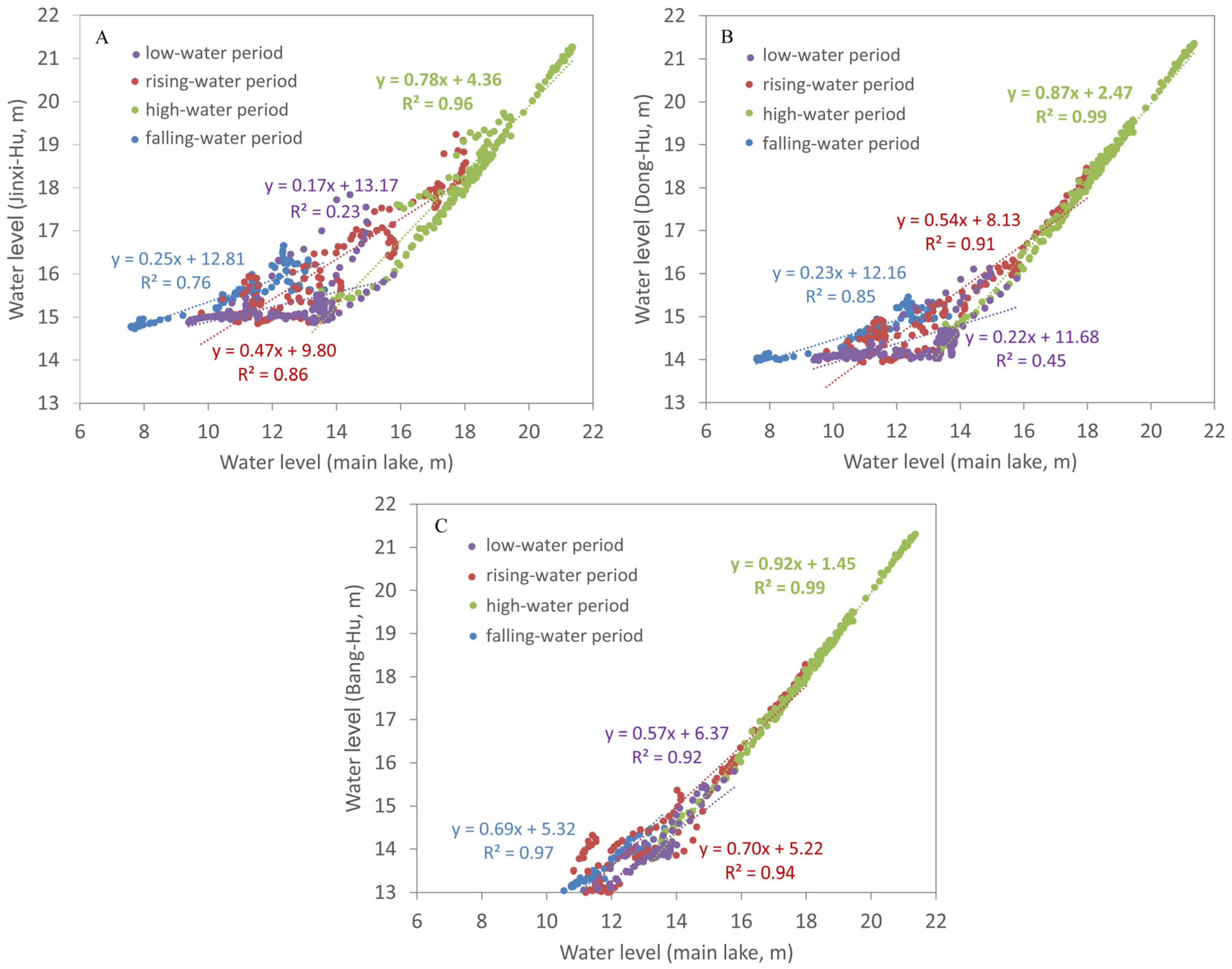
The saucer-shaped depression and main lake water levels were also investigated by regression analysis during the different water regime periods. The fitted and observed water levels for the saucer-shaped depressions are shown in Figure 4. The results indicate a very strong, periodically changing correlation between the depressions and the main lake. Generally, the correlation coefficients (R2) between main lake and depressions water levels show the highest value during the high-water period (mean value of 0.98) because they were hydrologically connected. However, as they were disconnected, the correlation gradually weakens. It shows a weaker relationship during the rising-water (mean value of 0.90) and falling-water (mean value of 0.86) periods. The correlation coefficient is at the lowest value (mean value of 0.53) during the low-water period, indicating a complete independence of the depressions from the main lake (Figure 4). In addition, we can find that in all water-regime periods, the strongest correlation of water level is between Bang-Hu and the main lake, and the correlation coefficients are 0.92, 0.94, 0.99 and 0.97, respectively (Figure 4C). The correlation of water level between the other depressions (Jinxi-Hu and Dong-Hu) and the main lake is poorer except during the high-water period. This also indicates that Bang-Hu has the highest degree of hydrological connectivity with the main lake.
4. Discussion
As mentioned above, there are several natural and human-made factors that can induce these particular water regime characteristics and water exchange processes between different saucer-shaped depressions and the main lake. First, water regimes in a depression may be influenced by meteorological factors, such as rainfall, air temperature and wind. During the connection phase, the frequency and duration of the connection mostly depend on the water level of the main lake, depression topography, morphology of the lake levees, and geographic position. Among these, natural levees may greatly impede or eliminate connectivity between depressions and the main lakes. During the isolation phase, there is no surface connection between the main lake and depressions, and the maximum water stage difference observed between the two was 6–7 m. Under these conditions, changes in the water regime of the depressions are mainly controlled by the watershed rainfall, local seepage and evaporation. Especially, precipitation patterns are important factor that explained the variations in depression levels across different seasons. Second, the construction of sluices between the lake and the depressions will inevitably lead to substantial changes in water regimes and hydrological connectivity. Especially, the fishing method “Lake Enclosed in Autumn” is unique and commonly used in the Poyang Lake; the method involves constructing an embankment around the depressions [23,33]. Local fishermen often release water from the depressions to catch as many fish as possible during the low-water season. Therefore, the “Lake Enclosed in Autumn” method may possibly influence the water regime and connectivity of the shallow depressions, and those impacts will depend on when and how water is released.
Water exchange and hydrological connectivity between saucer-shaped depressions and an adjacent main lake has many important implications for wetland biodiversity conservation, habitat characteristics, flood/drought risk management and hydraulic engineering projects. First, water level changes and hydrological connectivity can have both direct and indirect effects on the establishment of aquatic plants in the depressions. Shallow depressions located in different geographic regions ranging from the north to the south, respond differently to water level fluctuations. These hydrological patterns result in changes to the aquatic environments and can alter the plant communities [23]. Second, this study is of importance to delta morphological and ecological research. As water flows into the depressions, it carries sediment and nutrients, the differences in the connection of shallow depressions with the main lake should determine the distribution of nutrients and habitat diversity in the floodplain. It has been shown that numerous waterfowl and fish species use depressions for spawning nursery and foraging habitats in Poyang Lake [33]. The changing patterns of the connectivity degree can largely determine habitat diversity and the availability of foraging sites for fish stocks and migratory birds. The depressions with a lower degree of connectivity (such as Jinxi-Hu) may be likely to reduce the amount of habitat available for most aquatic biota during the onset of the falling-water period, exposing the marginal areas and reducing the hydraulic heterogeneity of water flow. However, with falling water levels, lentic habitats may increase in extent and new types of habitats may be created [34]. Third, hydrological connectivity between the lake and its depressions has important consequences for drought risk management and hydraulic engineering in Poyang Lake. For example, in recent years, the Poyang Lake Dam has been designed as a 2.8 km wide dam with sluice gates across the narrowest part of the channel that links Poyang Lake and the Yangtze River [35]. The proposal for this construction has aroused broad attention from ecologists, environmental protection organizations and the public [36]. According to the results of this research, we can better control the water level of the main lake to maintain appropriate water regimes in the different depressions. It could effectively guide the design of an optimal scheme of water level regulation, which is an important issue in hydraulic engineering at present.
5. Conclusions
The topographic depressions located at the wetland delta regions are typical floodplain shallow sub-lakes subject to river-lake connection or isolation. Hydrological connectivity is especially an important controlling factor on the frequency and degree of inundation of delta depressions, bring water, sediment, and nutrients to the depression interiors. But so far, much of our knowledge on the mechanisms behind the surface water exchange processes remains limited. To address this gap, this study demonstrates water level fluctuations and water exchange processes between Poyang Lake and its saucer-shaped depressions with high resolution water level observations from 2015 to 2016. Hydrological connectivity degree was quantified by identifying the timing and stage range of surface connectivity using information of height of the depressions relative to the water level in the main lake. The results of the connectivity analysis demonstrated that water exchange and connectivity degree of depressions have a clear spatio-temporal pattern. On the temporal scale, the rainfall significantly influences the seasonality and frequency of water level fluctuations in the Poyang Lake floodplain, revealing depressions from November-January, whereas there is a whole lake from May-July. Similarly, the hydrologic connectivity between the main lake and its depressions displayed a strong seasonal signal. The correlation coefficient between the water level of the main lake and its depressions show the highest value (mean value of 0.98) during the high-water period, followed by 0.90 during the rising-water period, 0.86 during the falling-water period and 0.53 during the low-water period. On the spatial scale, the connection duration slightly increases in the downstream direction and with a decreasing water level for the main lake. Depressions with a higher degree of connectivity are located mostly in the northern part and at a shorter distance from the main lake. It was also shown that the difference between the main lake water level and levee elevation of depressions exerts the primary control over the water exchange processes and creates connection and isolation thresholds within the system. Thus, the movement of water from the lake to the depressions and back to the lake is strongly dependent on depression topography and geographic positions, in addition to how well connected the two bodies are. We believe the findings here should have many significant implications for wetland biodiversity conservation, water resource and environmental management in the Poyang Lake. According to the results of this research, we can better control the water level of the main lake to maintain appropriate water regimes in the different depressions. It could effectively guide the design of optimal schemes of water level regulation, drought risk management, biodiversity conservation, hydraulic engineering projects, and so on.
Acknowledgments
This work was supported by the State Key Program of National Natural Science of China (41430855), National Natural Science Foundation of China (41401506). We are grateful Xingwang Fan, Huihui Feng, Han Zhou, Guojing Gan and Xin Pan who contributed to field work.
Author Contributions
Guiping Wu carried out data processing, data analysis and wrote the paper. Yuanbo Liu offered guidance to complete the work.
Conflicts of Interest
The authors declare no conflicts of interest.
References
- Long, C.M.; Pavelsky, T.M. Remote sensing of suspended sediment concentration and hydrologic connectivity in a complex wetland environment. Remote Sens. Environ. 2013, 129, 197–209. [Google Scholar] [CrossRef]
- Arias, M.E.; Cochrane, T.A.; Kummu, M.; Lauri, H.; Holtgrieve, G.W.; Koponen, J.; Piman, T. Impacts of hydropower and climate change on drivers of ecological productivity of Southeast Asia’s most important wetland. Ecol. Model. 2014, 272, 252–263. [Google Scholar] [CrossRef]
- Hudson, P.F.; Colditz, R.R. Flood delineation in a large and complex alluvial valley, lower Panuco basin, Mexico. J. Hydrol. 2003, 1, 229–245. [Google Scholar] [CrossRef]
- Wainwright, J.; Turnbull, L.; Ibrahim, T.G.; Lexartza-Artza, I.; Thornton, S.F.; Brazier, R.E. Linking environmental regimes, space and time: Interpretations of structural and functional connectivity. Geomorphology 2011, 3, 387–404. [Google Scholar] [CrossRef]
- Hayashi, M.; van der Kamp, G.; Rudolph, D.L. Water and solute transfer between a prairie wetland and adjacent uplands, 1. Water balance. J. Hydrol. 1998, 207, 42–55. [Google Scholar] [CrossRef]
- Amoah, J.K.; Amatya, D.M.; Nnaji, S. Quantifying watershed surface depression storage: Determination and application in a hydrologic model. Hydrol. Process. 2013, 17, 2401–2413. [Google Scholar] [CrossRef]
- Leira, M.; Cantonati, M. Effects of water-level fluctuations on lakes: An annotated bibliography. Hydrobiologia 2008, 1, 171–184. [Google Scholar] [CrossRef]
- Raulings, E.J.; Morris, K.; Roache, M.C.; Boon, P.I. The importance of water regimes operating at small spatial scales for the diversity and structure of wetland vegetation. Freshw. Biol. 2010, 3, 701–715. [Google Scholar] [CrossRef]
- Zhang, Q.; Ye, X.C.; Werner, A.D.; Li, Y.L.; Yao, J.; Li, X.H.; Xu, C.Y. An investigation of enhanced recessions in Poyang Lake: Comparison of Yangtze River and local catchment impacts. J. Hydrol. 2014, 517, 425–434. [Google Scholar] [CrossRef]
- Hiatt, M.; Passalacqua, P. Hydrological connectivity in river deltas: The first-order importance of channel-island exchange. Water Resour. Res. 2015, 51, 2264–2282. [Google Scholar] [CrossRef]
- Sabo, M.J.; Bryan, C.F.; Kelso, W.E.; Rutherford, D.A. Hydrology and aquatic habitat characteristics of a riverine swamp: II. Hydrology and the occurrence of chronic hypoxia. River Res. Appl. 1999, 6, 525–544. [Google Scholar] [CrossRef]
- Dutta, D.; Teng, J.; Vaze, J.; Lerat, J.; Hughes, J.; Marvanek, S. Storage-based approaches to build floodplain inundation modelling capability in river system models for water resources planning and accounting. J. Hydrol. 2013, 504, 12–28. [Google Scholar] [CrossRef]
- Karim, F.; Dutta, D.; Marvanek, S.; Petheram, C.; Ticehurst, C.; Lerat, J.; Yang, A. Assessing the impacts of climate change and dams on floodplain inundation and wetland connectivity in the wet–dry tropics of northern Australia. J. Hydrol. 2015, 522, 80–94. [Google Scholar] [CrossRef]
- Coops, H.; Buijse, L.L.; Buijse, A.D.T.; Constantinescu, A.; Covaliov, S.; Hanganu, J.; Staras, M. Trophic gradients in a large-river Delta: Ecological structure determined by connectivity gradients in the Danube Delta (Romania). River Res. Appl. 2008, 5, 698–709. [Google Scholar] [CrossRef]
- Hudson, P.F.; Sounny-Slitine, M.A.; LaFevor, M. A new longitudinal approach to assess hydrologic connectivity: Embanked floodplain inundation along the lower Mississippi River. Hydrol. Process. 2013, 15, 2187–2196. [Google Scholar] [CrossRef]
- Nilsson, K.A.; Rains, M.C.; Lewis, D.B.; Trout, K.E. Hydrologic characterization of 56 geographically isolated wetlands in west-central Florida using a probabilistic method. Wetl. Ecol. Manag. 2013, 1, 1–14. [Google Scholar] [CrossRef]
- Gooseff, M.N.; Wlostowski, A.; McKnight, D.M.; Jaros, C. Hydrologic connectivity and implications for ecosystem processes-Lessons from naked watersheds. Geomorphology 2017, 277, 63–71. [Google Scholar] [CrossRef]
- Finlayson, M.; Harris, J.; McCartney, M.; Lew, Y.; Zhang, C. Report on Ramsar Visit to Poyang Lake Ramsar Site, PR China 12-17 April 2010; Report prepared on behalf of the Secretariat of the Ramsar Convention; The Ramsar Convention of Wetlands: Gland, Switzerland, 2010; Available online: http://archive.ramsar.org/pdf/Poyang_lake_report_v8.pdf (accessed on 15 January 2011).
- Dronova, I.; Gong, P.; Clinton, N.E.; Wang, L.; Fu, W.; Qi, S.; Liu, Y. Landscape analysis of wetland plant functional types: The effects of image segmentation scale, vegetation classes and classification methods. Remote Sens. Environ. 2012, 127, 357–369. [Google Scholar] [CrossRef]
- Hui, F.; Xu, B.; Huang, H.; Yu, Q.; Gong, P. Modelling spatial-temporal change of Poyang Lake using multitemporal Landsat imagery. Int. J. Remote Sens. 2008, 29, 5767–5784. [Google Scholar] [CrossRef]
- Wu, G.P.; Liu, Y.B. Capturing variations in inundation with satellite remote sensing in a morphologically complex, large lake. J. Hydrol. 2015, 523, 14–23. [Google Scholar] [CrossRef]
- Feng, L.; Hu, C.M.; Chen, X.L.; Cai, X.B.; Tian, L.Q.; Gan, W.X. Assessment of inundation changes of Poyang Lake using MODIS observations between 2000 and 2010. Remote Sens. Environ. 2012, 121, 80–92. [Google Scholar] [CrossRef]
- Hu, Z.P.; Zhang, Z.F.; Liu, Y.Z.; Ji, W.T.; Ge, G. The function and significance of the Shallow-Lakes in the Poyang Lake wetland ecosystem. JiangXi Hydraul. Sci. Technol. 2015, 5, 317–323. (In Chinese) [Google Scholar]
- Jiang, J.H.; Huang, Q. Analysis on relationship of water exchange between Banghu Lake and Poyang Lake. J. Lake Sci. 1996, 3, 208–214. (In Chinese) [Google Scholar]
- Shankman, D.; Keim, B.D.; Song, J. Flood frequency in China’s Poyang Lake region: Trends and teleconnections. Int. J. Climatol. 2006, 9, 1255–1266. [Google Scholar] [CrossRef]
- Qi, S.H.; Brown, D.G.; Tian, Q.; Jiang, L.; Zhao, T.; Bergen, K.M. Inundation extent and flood frequency mapping using LANDSAT imagery and digital elevation models. GISci. Remote Sens. 2009, 1, 101–127. [Google Scholar] [CrossRef]
- Karim, F.; Kinsey-Henderson, A.; Wallace, J.; Arthington, A.H.; Pearson, R.G. Modelling wetland connectivity during overbank flooding in a tropical floodplain in north Queensland, Australia. Hydrol. Process. 2012, 26, 2710–2723. [Google Scholar] [CrossRef]
- Hudson, P.F.; Heitmuller, F.T.; Leitch, M.B. Hydrologic connectivity of oxbow lakes along the lower Guadalupe River, Texas: The influence of geomorphic and climatic controls on the “flood pulse concept”. J. Hydrol. 2012, 414, 174–183. [Google Scholar] [CrossRef]
- Drago, E.C. The Physical Dynamics of the River—Lake Floodplain System, in the Middle Paraná River: Limnology of Subtropical Wetland; Springer: Berlin, Germany, 2017; pp. 83–122. [Google Scholar]
- Djebou, D.C.S. Spectrum of climate change and streamflow alteration at a watershed scale. Environ. Earth Sci. 2017, 76, 653. [Google Scholar] [CrossRef]
- Djebou, D.C.S. Integrated approach to assessing streamflow and precipitation alterations under environmental change: Application in the Niger River Basin. J. Hydrol. Reg. Stud. 2015, 4, 571–582. [Google Scholar] [CrossRef]
- Chang, L.Y.; Xu, J.M.; Tie, X.X.; Wu, J.B. Impact of the 2015 El Nino event on winter air quality in China. Sci. Rep. 2016, 6, 1–6. [Google Scholar] [CrossRef] [PubMed]
- Wang, W.; Fraser, J.D.; Chen, J. Wintering waterbirds in the middle and lower Yangtze River floodplain: Changes in abundance and distribution. Bird Conserv. Int. 2017, 2, 167–186. [Google Scholar] [CrossRef]
- Lake, P.S. Ecological effects of perturbation by drought in flowing waters. Freshw. Biol. 2003, 7, 1161–1172. [Google Scholar] [CrossRef]
- Dam Proposal for Poyang Lake Causes Wave of Controversy. Available online: http://www.chinadaily.com.cn/cndy/2011-08/04/content_13045840.htm (accessed on 8 April 2011).
- Qi, S.H.; Liao, F.Q. A study on the scheme of water level regulation of the Poyang Lake hydraulic project. Acta Geogr. Sin. 2013, 1, 118–126. (In Chinese) [Google Scholar]
Figure 1.
Geographic location of Poyang Lake in China. Yellow outlines delineate saucer-shaped depressions. The base map was produced using a combination of Landsat Thematic Mapper (TM) bands 4, 3, and 2, which were acquired in December 2013.
Figure 1.
Geographic location of Poyang Lake in China. Yellow outlines delineate saucer-shaped depressions. The base map was produced using a combination of Landsat Thematic Mapper (TM) bands 4, 3, and 2, which were acquired in December 2013.

Figure 2.
The study sites and context. Sub-figure (A): yellow outline shows study sites, and locations of water level loggers are shown as red dots. Sub-figure (B): the water level logger was anchored in place with steel fence posts, with the steel cable running along the lake bed in a plastic pipe. Sub-figure (C): Bang-Hu during high water level conditions, 2 February 2015. Sub-figure (D): Bang-Hu during low water level conditions, 18 May 2015.
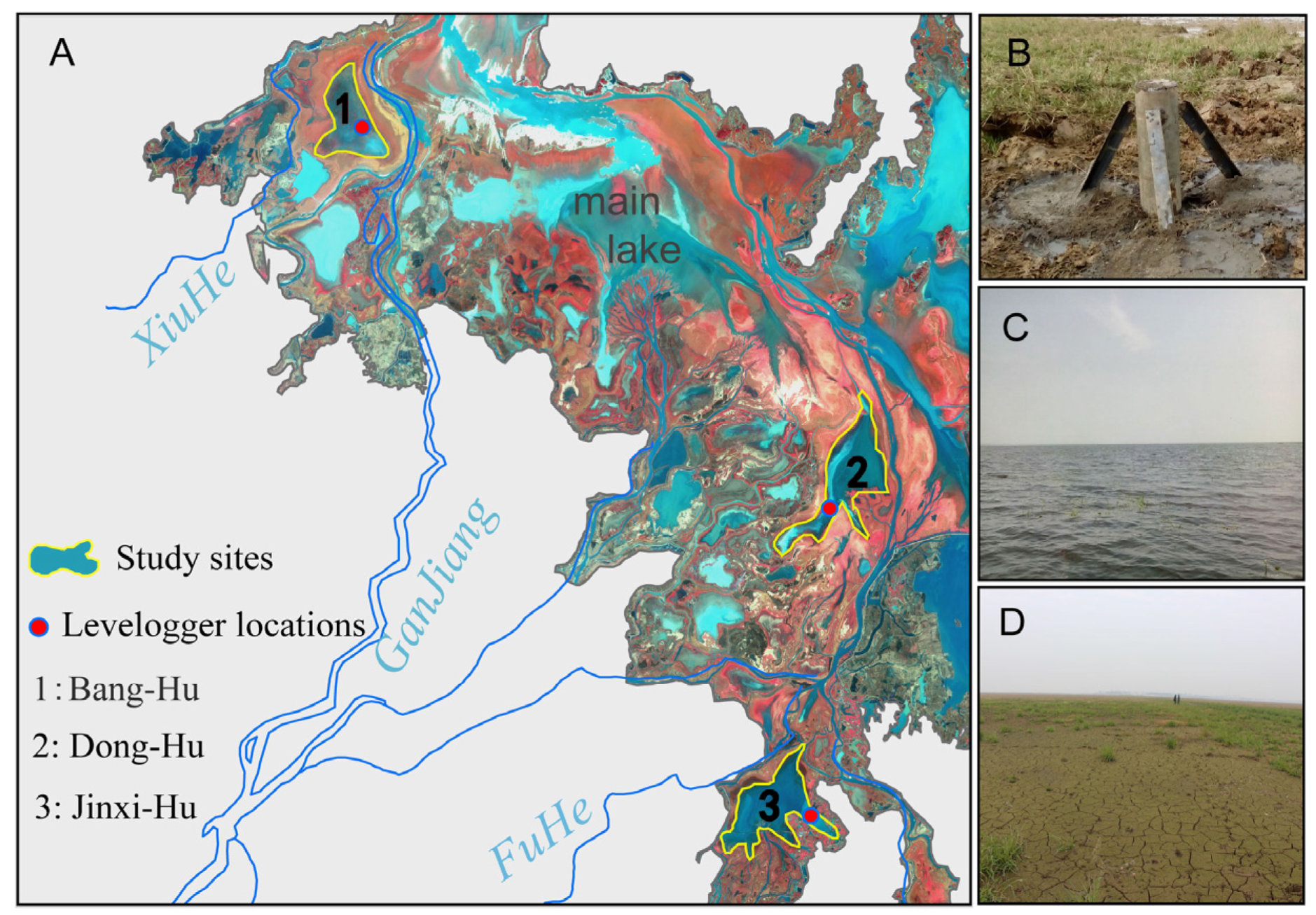
Figure 3.
Comparison of lake/depressions water level (m) and rainfall (mm/month) from 2015 to 2016. Sub-figure (A): Water level changes in the saucer-shaped depressions and main lake showing the duration of connection and isolation phases in different periods. The red dotted line highlights a period of increases precipitation. Sub-figure (B) The pattern of rainfall variation within the Poyang Lake basin.

Figure 4.
Water levels of (A) Jinxi-Hu, (B) Dong-Hu and (C) Bang-Hu vs main lake body, with associated R2 indicated during different water regime periods. Lines represent results of linear regression analysis.
Figure 4.
Water levels of (A) Jinxi-Hu, (B) Dong-Hu and (C) Bang-Hu vs main lake body, with associated R2 indicated during different water regime periods. Lines represent results of linear regression analysis.


Table 1.
List of the geographical and physical features of the study sites and gauging stations.
| Study Sites | Longitude | Latitude | Bottom Elevation (m) | Area (km2) |
|---|---|---|---|---|
| Bang-Hu | 115°57′ E | 29°13′ N | 14.55 | 33.65 |
| Dong-Hu | 116°22′ E | 28°57′ N | 15.06 | 35.78 |
| Jinxi-Hu | 116°18′ E | 28°43′ N | 15.44 | 36.84 |
| Gauging Stations | Longitude | Latitude | Location | Drainage Area (km2) |
| Wanjiabu | 115°39′ E | 28°51′ N | XiuHe | 3548 |
| Waizhou | 115°50′ E | 28°38′ N | GanJiang | 80,948 |
| Lijiadu | 116°10′ E | 28°13′ N | FuHe | 15,811 |
| Meigang | 116°49′ E | 28°26′ N | XinJiang | 15,535 |
| Hushan | 117°16′ E | 28°55′ N | RaoHe | 6374 |
Table 2.
Water stage heights of hydrological phases in different saucer-shaped depressions during 2015–2016.
Table 2.
Water stage heights of hydrological phases in different saucer-shaped depressions during 2015–2016.
| Year | Lake Phases | Jinxi-Hu | Dong-Hu | Bang-Hu | ||||
|---|---|---|---|---|---|---|---|---|
| Water Level (m) | Date | Water Level (m) | Date | Water Level (m) | Date | |||
| 2015–2016 | rising-water | isolation | 7.61–17.5 | 2/15–6/10 | 7.61–16.1 | 2/15–6/3 | 7.61–14.05 | 2/15–5/16 |
| connection | 17.5–19.46 | 6/10–6/24 | 16.1–19.46 | 6/3–6/24 | 14.05–19.46 | 5/16–6/24 | ||
| falling-water | connection | 19.46–15.81 | 6/24–8/5 | 19.46–15.15 | 6/24–8/7 | 19.46–14.68 | 6/24–8/9 | |
| isolation | 15.81–9.83 | 8/5–3/8 | 15.15–9.83 | 8/7–3/8 | 14.68–9.83 | 8/9–3/8 | ||
| rising-water | isolation | 9.83–17.95 | 3/8–5/12 | 9.83–16.39 | 3/8–4/22 | 9.83–14.23 | 3/8–4/13 | |
| connection | 17.95–21.35 | 5/12–7/12 | 16.39–21.35 | 4/22–7/12 | 14.23–21.35 | 4/13–7/12 | ||
| falling-water | connection | 21.35–14.77 | 7/12–9/5 | 21.35–14.08 | 7/12–9/7 | 21.35–13.59 | 7/12–9/9 | |
| isolation | >14.77 | 9/5– | >14.08 | 9/7– | >13.59 | 9/9– | ||
© 2017 by the authors. Licensee MDPI, Basel, Switzerland. This article is an open access article distributed under the terms and conditions of the Creative Commons Attribution (CC BY) license (http://creativecommons.org/licenses/by/4.0/).
Share and Cite
MDPI and ACS Style
Wu, G.; Liu, Y. Seasonal Water Exchanges between China’s Poyang Lake and Its Saucer-Shaped Depressions on River Deltas. Water 2017, 9, 884. https://doi.org/10.3390/w9110884
AMA Style
Wu G, Liu Y. Seasonal Water Exchanges between China’s Poyang Lake and Its Saucer-Shaped Depressions on River Deltas. Water. 2017; 9(11):884. https://doi.org/10.3390/w9110884
Chicago/Turabian StyleWu, Guiping, and Yuanbo Liu. 2017. "Seasonal Water Exchanges between China’s Poyang Lake and Its Saucer-Shaped Depressions on River Deltas" Water 9, no. 11: 884. https://doi.org/10.3390/w9110884
Note that from the first issue of 2016, this journal uses article numbers instead of page numbers. See further details here.