1. Introduction
Recent collaborative approaches to watershed science are looking at water relationally, integrating hydrology, geomorphology and ecology and seeking insights from indigenous and other land-based knowledge systems. Some academic and agency scientists within these collaboratives are rejecting old paradigms of river regulation and watershed management that center human use and control, instead conceiving of approaches that maximize the health and resilience of interconnected human and ecological communities. In this paper, I explore how such collaborations can transform environmental governance processes and the practice of ecosystem science itself, and, in so doing, undermine some of the most harmful legacies of human exceptionalism that originate in Manifest Destiny thinking during the rise of riverine science. (Here, I am in dialog with Marxist water scholars, including Joe Linton, Erik Swyngedouw and Richard White, who focus primarily on modern hydrology’s neglect of social water relations [
1,
2,
3]. Modern hydrologic science’s abstraction of water conceptually from within human social relations was key to, and developed along with, engineer’s designs for 20th century waterworks. I develop this argument more fully in [
4,
5]).
Hydraulic engineering and water governance have been tightly linked in the U.S. since the first river control schemes emerged as central strategies projects to consolidate settler territorial claims into agricultural and urban economies [
6,
7,
8,
9]. Early water engineers dismissed indigenous and other traditional knowledge that was primarily empirical, situated and, thus, un-abstractable [
10,
11,
12,
13], instead developing physically-based models that facilitated the abstraction of water from social-ecological systems [
14]. Riverine science thus lacked the insights, foundational to indigenous watershed management in western North America, that upstream-downstream connectivity of water, sediment and salmon and stochastic processes, like flood, drought and fire, sustain the wide range of species that, in turn, sustain indigenous material culture [
15,
16]. Riverine engineering schemes and wildfire suppression thus drastically reduced ecological productivity and resilience. Settler legal doctrines undermined destroyed commons governance arrangements that had facilitated tribal management of resources like salmon, acorns, and shellfish. Along California’s North Coast streams, private property regimes on land have created commons tragedies in groundwater and salmon fisheries, both classic examples of commons that are often governed collectively and sustainably by their users [
17]. Understanding the linkages between salmon and groundwater is one major focus of salmon recovery and climate change adaptation planning in central California and increasingly throughout the Pacific Northwest.
In this paper, I explore how, in one water-scarce, salmon-bearing watershed on California’s central coast, collaborators are synthesizing agency and landowner data on groundwater and salmon management and explore some of the social and cultural dimensions of those collaborative projects that have, in some cases, created a new sense of ecological possibility in the region. (In discussing ecological possibility, I am inspired by Angela Willey’s notion of biopossibility, that by broadening cultural interpretations of biological data (in her case, studies of monogamy and pair bonding using voles), scientists can create new possibilities for researching and understanding their study systems [
18]). I also consider some limitations of this collaborations, namely the lack of engagement with indigenous Pomo and Miwok tribal members, with the Confederated Tribes of Graton Rancheria, and with farmworkers and other marginalized residents, and suggest strategies for deepening environmental justice commitments in future collaborative work.
In Mediterranean-climate regions of California and southern Oregon, juvenile salmon depend on groundwater aquifers to sustain their tributary habitats through the dry summers. In the absence of self-regulation, such commons undergo ‘tragic’ depletion. Water diversions and habitat changes have decimated aquatic ecosystems in the state, leading to the near-extinction of 83% of its native fish taxa and 78% of its native salmonid species, among other aquatic species [
19,
20]. Groundwater mining has also burdened rural communities reliant on groundwater for household supply. When dropping water tables have concentrated pollutants or dried up wells completely, low-income residents and residents of color have been disproportionately affected [
21,
22].
State regulatory limits may avert resource depletion, and can enable local institutions to craft rules and management policies that foster new conceptions of environmental citizenship (which Agrawal [
23] calls environmentality). However, until very recently, California and federal law did not recognize salmon and groundwater commons as such. Only with the 2014 Sustainable Groundwater Management Act did this begin to shift for groundwater. Federal recovery plans for Endangered Species Act—(ESA) listed species regulate land and water use practices that kill salmonids directly or degrade their habitat. Surface water regulations have, in limited instances, been applied to a narrow ‘zone of interconnection’ with near-stream aquifers; however, these regulations are imposed by the state, rather than administered by users themselves. However, both ESA and water regulations are unevenly enforced.
Top down approaches, long dominant in environmental governance in California, have often been science-driven, as evidenced by the Delta Stewardship Council’s Delta Science Program and the Safeguarding California climate adaptation strategy [
24,
25]. Top down governance alone has not served ecosystems well during the 2011–16 drought [
26], or even during wet periods [
27], for several reasons. Weak regulations and conflicting agency mandates limit monitoring and enforcement of surface water diversions and stream habitat degradation. Landowners have for several decades mounted political challenges to state water regulatory efforts, favoring self-regulation and voluntary measures. In response, resource conservation districts, NGOs, and private consultants have coordinated grant-funded flow and habitat restoration efforts, because regulation under the public trust doctrine or limits to development are politically unpopular at the state and county levels.
Recently, the state has embraced decentralized infrastructures and self-governance as adjuncts to centralized waterworks, recognizing that all good dam sites are developed, that climate change is changing runoff dynamics, and that in drought years, federal endangered species mandates cannot be met with existing water management practices. Furthermore, vast areas of private land and private wells that are nominally subject to state regulation escape
de facto regulation by agencies because they are too small or remote to warrant attention, or are managed cooperatively with funding from resource conservation districts and other local entities [
22,
28]. In these areas, landowners or citizen groups manage wildlife, forests, rangelands, wetlands, waterways, and groundwater. Within this changing regulatory and funding landscape, I will argue that collaborative, transdisciplinary science that supports local self-regulation and governance can produce novel understandings of riverine ecosystem function. These approaches bring stakeholders together around climate adaptation and river rehabilitation efforts, and re-invigorate commons governance regimes, but are rare because most academic and agency scientists lack the training and support to facilitate such collaboratives. (The academic and agency scientists I encountered were all trained in narrow disciplinary modes, as biologists or geomorphologists. They lacked training in social science (or on-the-ground community organizing experience) that would have enabled them to critically engage the social and political dynamics at play, and such work fell outside of their job descriptions.) In some cases, tribes, NGOs, intertribal resource management agencies, and grassroots can and often do facilitate such collaboratives, and some agencies hire social scientists to do this work. In the remainder of the paper, I focus on my role as a scientist in facilitating one collaboration and provide a model for other scientists who may want to engage in such work, but don’t investigate further why agency scientists in this region were not facilitating such collaboratives.
1.1. Transgressive Riverine Knowledge Collaboratives Confront Drought and Changing Climate
This paper explores the role of transdisciplinary scientific collaborations in fostering new governance structures, scientific practices, regulatory tools, and drought adaptation projects. Salmon in these streams are a commons within a commons; their decline results both from overfishing of adults in the ocean and through depletion of ground and surface waters, leading to juvenile mortality. In North Coast streams, the imminent extinction of coho salmon and other aquatic species spurred the emergence of new collaborative scientific and management initiatives among agencies, tribes, private landowners, university researchers, and grassroots groups in the early 2000s and produced new understandings of the links between human water use and aquatic ecosystem decline [
29,
30,
31]. In my Salmon Creek study area, local residents formed a watershed council and secured funding to study stream conditions, pumping impacts, and water quality in the estuary. One study demonstrated that groundwater pumping by the Bodega Water Company accelerated stream drying and water quality impairment [
32]. Armed with this data and cooperation from landowners, the ad hoc collaborative secured funding for a large rainwater harvesting project to replace pumped groundwater for municipal and agricultural supply near the town of Bodega.
The tanks were installed during the extraordinary dry spell that began in 2012, which exacerbated water scarcity for residential and agricultural water users and caused catastrophically dry conditions in aquatic ecosystems [
33]. In response, state and local water agencies and federal and state fisheries agencies crafted regulations and cooperative agreements intended to stave off salmonid extinction while protecting human livelihoods. Negotiations around water rights, forbearance agreements, and the responsibilities that accrue to riparian landowners who participate in habitat enhancement projects are still being negotiated at the state and federal level. Although lessons learned from these projects may feed into minimum-flow regulation or support future grant applications, some partners may be wary of sharing data: farmers and residents because they fear government regulation and watershed councils and resource conservation districts because they want to protect their access agreements with landowners. On the other hand, anecdotal evidence suggests that regulation may increase local resident’s awareness of and appreciation for aquatic species, and witnessing the successful recovery of salmon runs may motivate some to redouble water conservation efforts or engage in local restoration and monitoring efforts. Despite the ongoing regulatory uncertainties, many more residential and agricultural landowners are seeking grants to install tanks, ponds, and groundwater recharge basins in order to be better prepared for the next dry spell [
34].
In light of this recent history, I ask, what institutional arrangements are emerging in times of drought to cope with scarcity? Do these arrangements transgress boundaries between regulatory agency, academic, indigenous, citizen science, and/or local (settler) knowledge, and to what extent? To what extent do existing and emerging watershed governance institutions recognize water and fish as commons (rather than as private or state property)? Mixed results from voluntary flow and habitat enhancement projects suggest critical, more broadly applicable questions: Are collaborative science and top-down regulation at odds in salmon recovery on Mediterranean climate streams? How can we understand synergistic potential and incommensurability of these two tactics?
Building on my earlier findings that some local residents consider local streams, aquifers, and salmon runs to be commons that should be regulated collectively by their users, this paper explores incipient and emerging institutional arrangements that grow out of different environmental imaginaries [
35] related to salmon and water. The term environmental imaginaries was coined by political ecologists’ Peet and Watts in 1996 to describe how people collectively imagine their relations to their local environments, especially in the context of resistance to environmental destruction. I first briefly describe my participatory and mixed-methods approach, which brought together local knowledge, citizen science, and expert science around salmon and water into what I term transgressive knowledge collaboratives (see definition below). I then describe three collaborative scientific practices extant in Salmon Creek that are facilitating new governance strategies and discuss their implications for: (1) California water and salmon governance, science, and monitoring at different scales; and (2) recovery of aquifers, aquatic habitats, and salmonids in coastal streams. First, however, I turn briefly to the social science and science and technology study literature on collaborative science and relations between expert, indigenous, and local knowledge in environmental governance.
1.2. Transgressive Knowledge Collaboratives Defined
I define transgressive knowledge collaboratives as knowledge production projects that work across indigenous, local, and technoscientific knowledges without privileging any one mode of knowing. Instead, practitioners note tensions, incommensurabilities, and moments of synergy among different ontologies and epistemologies, while working for common ecological goals. My term, transgressive knowledge collaboratives, shares with Fox’s 2003 term ‘transgressive research’ a commitment to a method of action research that focuses on practical problems identified by the researcher in conversation with the community partner, decenters academic and expert knowledge, and sees theory building as an adjunct to practical activity [
36]. In substituting ‘knowledge collaboratives’ for ‘research’, my term emphasizes the creation of working groups that can produce knowledge that is useful beyond a scientific research setting, explicitly taking up Haraway’s call for feminist scientists consider scientific and local knowledges as situated and mobilizes a decolonial critique of science practiced in settler-colonial contexts for its frequent failure to center indigenous people, tribal sovereignty, and co-management practices.
Over the course of my fieldwork in Salmon Creek, I came to this concept as a way to combine grounded theory’s iterative generation of research questions in dialog with research participants, participatory action research’s commitment to producing knowledge relevant to community concerns, and transdisciplinary science’s interest in talking across scientific disciplines and across the science-local knowledge divide. I also critically examined these approaches’ limitations with indigenous and feminist science studies theory. To foreshadow the conclusion, while the project was exemplary in terms of co-production, collective, transformative, and transdisciplinary knowledge, it failed in decolonial terms because the collaborative did not engage with local tribes or take on questions of indigenous sovereignty and co-management. The project has, so far, only partly succeeded in bringing situated knowledges and feminist science studies analysis into science and policy forums.
Key to working in transdisciplinary knowledge collaboratives is the recognition that practitioners differ in what they believe counts as knowledge, and have different goals in pursuing research (e.g., generating theory, collecting empirical data, testing models, or solving a practical problem) [
36,
37,
38,
39]. Feminist, indigenous, and postcolonial scholars have challenged narrow or token collaborations among experts and other knowledge-holders, drawing attention to power relations, epistemic violence, and the partial perspective of all science, including western science [
11,
40,
41,
42,
43,
44,
45]. These critiques apply to many cases of transdisciplinary science, a field that emerged in landscape ecology in the 1990s [
46] and has expanded to include global sustainability science and the study of social ecological systems [
47,
48,
49,
50]. Researchers have developed participatory, action-based, and justice-seeking methodologies as alternatives to outsider investigations of environmental and environmental health problems [
38,
51,
52,
53,
54]. These approaches, while divergent in method and content, share several key commitments: to reflexivity, to setting goals together, and to shared authorship, though these commitments do not always hold up in practice.
Inclusive and collaborative approaches seem well suited for adaptive management along rivers because they can integrate fishers’ and water users’ ways of measuring and monitoring with regulatory agency or academic methods. However, the promise of adaptive management—to undertake environmental management as a series of scientific experiments, incorporate interdisciplinary evaluation methods and apply lessons learned to future projects—has rarely been realized, due to funding constraints and institutional barriers [
55,
56]. Furthermore, large, agency-driven adaptive management processes rarely include local residents in goal setting, monitoring, and evaluation [
57,
58,
59]. Indigenous, postcolonial, and feminist science and technology studies (STS) scholars propose new ways of doing science that blur boundaries between disciplines, asserting that transgressing the situated knowledge bases of scientists, practitioners, and local residents yields a stronger objectivity and more robust results [
40,
60,
61,
62,
63]. Few, however, conduct collaborative technoscientific research projects that enact these principles (for an exception see Subramanian [
45]). In developing my experience as ecologist and ethnographer and STS scholar into a method, I hope that other ecologists will build on our collaborative experience in Salmon Creek and expand these innovative practices within riverine science and management.
2. Study Area and Overview of the Case
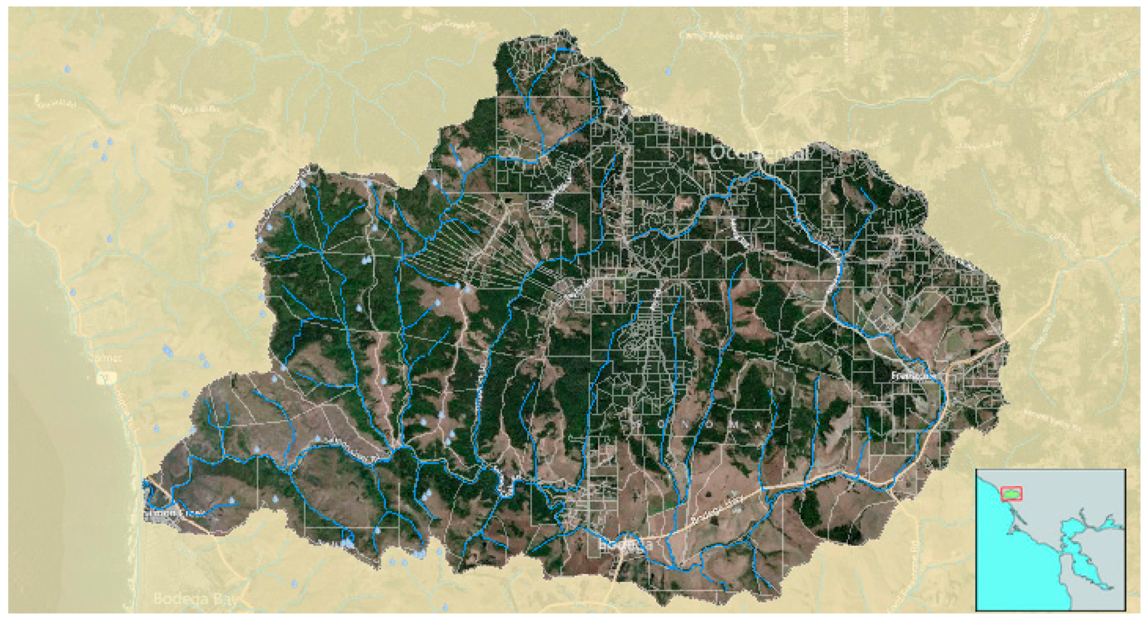
Salmon Creek (Sonoma County, CA, USA) is an un-dammed stream that drains a 91-square-kilometer watershed characterized by scattered rural development amidst pasture, vineyards, and mixed hardwood and redwood forest (
Figure 1). Land use conversion, channel modification, water extractions, and water pollution have altered the quantity, quality, and timing of in-stream flows, limiting the recovery of threatened steelhead (
Oncorhynchus mykiss) and endangered coho salmon (
O. kisutch). Coho salmon went extinct in the watershed in the 1990s, and have been reintroduced through the Russian River Captive broodstock program; steelhead never disappeared, but their numbers have dropped precipitously since the 1970s [
30]. California’s Mediterranean climate delivers most of its annual rainfall between October and April; many tributary reaches dry into disconnected pools between July and September. Anthropogenic drought (defined as accelerated stream drying due to human over-extraction) compounds historical watershed modifications (e.g., beaver removal, logging, road building) that have drastically altered fluxes of water, sediment, and large woody debris to streams like Salmon Creek. Reducing human water diversions during summer is a key objective in salmon recovery, since summer is when this anthropogenic drought compounds natural drying, reducing habitat volume and concentrating pollutants, and thereby increasing stress to aquatic organisms [
31].
Salmon Creek is geographically small and removed from major river basins, yet functions as a kind of microcosm of the political, cultural, and ecological tempests water and fisheries governance stir up at larger scales. Salmon are simultaneously a global fishery resource, a key subsistence and cultural resource for traditional peoples around the Pacific, a technoscientific project to avert extinction, and a contested site of knowledge production. Salmon Creek’s hydrology is typical of many streams in the Pacific west, and its intermittent condition will likely spread northward with climate change [
64,
65,
66]. Small coastal streams provide key population refugia for anadromous species such as salmon, because they often lack dams or storm channels that block fish passage from the ocean, and may select for different traits and life histories than nearby large rivers [
67,
68]. As social sites, small watersheds provide an opportunity to study the interplay between rural communities and the biophysical settings that shape and get shaped by rural identities. Finally, Salmon Creek is adjacent to the larger, more conflicted, and much better-studied Russian River watershed, and is subject to many of the same regulatory, political, and legal issues that accompany the Endangered Species Act listing of coho salmon in this region.
3. Approach
Seeking to field test transgressive collaborative knowledge practices in hydro-ecologic research, I undertook a collaborative inquiry into social and ecological dimensions of water scarcity in the Salmon Creek watershed between 2011 and 2015. My first year of research involved meetings, interviews, and field visits with many of the groups with a stake in watershed rehabilitation projects. Through these meetings, I developed several possible research questions, then asked collaborators which ones touched on their own goals. This approach was informed by grounded theory, in which the researcher allows questions and themes to emerge from extended ethnography, and participatory action research, in which the researcher investigates questions proposed by the local community, and was also informed by critical feminist and decolonial critiques of these methods, as discussed above.
Consultation alone does not make a collaboration transgressive. Indeed, alternatives to top-down modes of research, in which a researcher arrives in a community with their questions selected, and then perhaps consults with local residents and collaborators on details of method or interpretation, has become increasingly common in development studies and public health, and this a good thing [
69,
70,
71]. However, the approach I pursued takes collaboration further than these studies. I spent my first six months in the field accompanying different citizen scientists, creek walkers, agency scientists, and consultants on field surveys, observing what they measured and asking what questions they thought were most important. I made my own commitments explicit in these conversations; commitments to studying how water scarcity affected humans and other species, to understanding feedbacks between social and ecological systems and to bringing together local and scientific practices. In my second year of research, I began a hydroecological study of how stream drying affects juvenile salmonid survival, which grew out of these consultations. The study included a biological assessment in partnership with the Gold Ridge Resource Conservation District (RCD), a hydrologic mapping effort in partnership with the Salmon Creek Watershed Council and local residents, and a groundwater flow paths study in cooperation with local residents, utilizing samples collected from their wells. In years 3, 4, and 5 of the project, I facilitated annual research collaborative workshops that each brought together forty participants representing diverse interests to explore different ways of monitoring and interpreting social-ecological processes evolving in the watershed.
In the remainder of this paper, I explore transgressive collaborative knowledge practices, using the collaborative I spearheaded in Salmon Creek as a case (
Table 1). I focus on three examples of monitoring and analyzing hydro-ecological phenomena: (1) salmon spawning success and juvenile salmonid presence; (2) well and spring dynamics; and (3) streamflow recession and wet/dry patterns in streams.
In each case, I address a set of questions related to measurement: Who does the measuring? What do they measure? What motivates them to collect this data? What data do they no longer collect, and why? Are their methods commensurable with other methods for measuring the same thing? How have new technologies changed their strategies for managing and sharing data? How do reasons for collecting data and the ways it is put to use differ among groups of data collectors? I also address a set of questions related to collaboration: With whom do people collaborate and share data, and how did they come to do so? Who chooses not to collaborate? Which collaborations have been sustained, and why? After examining each of the three field collaborations as possible cases of transgressive collaborative knowledge practices in action, I discuss the collaborative workshops as crucibles for forging new ways of doing science. I then discuss the (in)commensurability of different kinds of knowledges and the potential to mobilize them in different watershed governance frameworks (top-down, decentralized, watershed-scale). Following feminist STS scholars, I pay attention to the social nature of knowledge production, the boundaries people draw around their study systems, and the resulting views of agency, collaborative possibilities, and inter-species reciprocity that result.
Collaborative Workshops: Transgressive Epistemologies in Practice
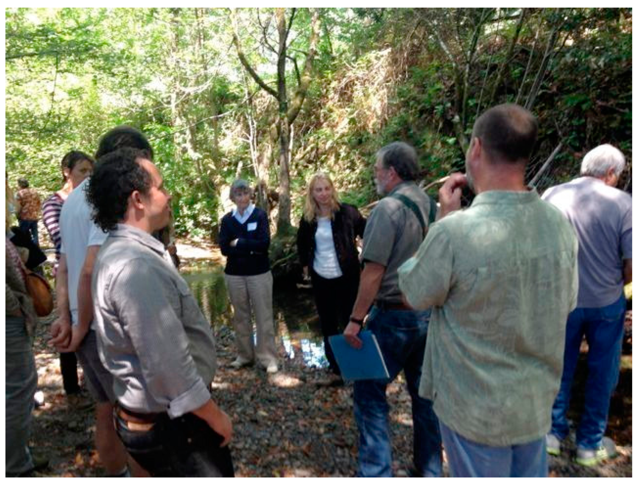
Throughout my research process, I sought to make use of different kinds of hydrological and ecological knowledge, and challenged agency scientists to take seriously data and other knowledge that different residents possess. I did this informally, by passing records and information among citizen scientists, RCD and National Marine Fisheries Service scientists, consulting scientists, and local residents. I also organized two collaborative science workshops, inviting agency scientists, UC Berkeley academics, local experts such as creek walkers (locals who walk creeks and note fish presence and changes in habitat) and well drillers, watershed council citizen scientists, ranchers and residents.
The first workshop focused on salmon science, the second focused on groundwater by request of local residents, and in the third we collectively reflected on knowledge gained during the study. Upon arrival at each workshop, participants self-identified by the discipline they represented (the choices were aquatic biology/fish, hydrology/groundwater, geomorphology/soils, social science, and terrestrial biology/forestry and range management). I invited different kinds of experts to make short presentations, and introduced them by stating that all different kinds of expertise, including that of ranchers and amateur naturalists, was a critical partial perspective (to use Haraway’s term [
11]); taken together, these partial perspectives increase collective knowledge of the system. Participants then broke up into disciplinary groups. The groups discussed key knowledge gaps and research goals concerning salmon, groundwater, roads and sediment, upland forests and prairies, and household water use. Each group included representatives from different agencies and citizen groups, and a lively discussion ensued. Over lunch, participants examined different data collection instruments that they used to sense the watershed. At an afternoon field activity that took place in the creek, I asked different participants to explain how they saw the stream: what specifically they looked for and recorded when they went into the field (
Figure 2). This activity was particularly rich as scientists from different disciplines realized how different their practices were, and also considered how lay science methods might complement their own.
Several concrete collaborations resulted from the first workshop. First, a geomorphologist at the Gold Ridge RCD saw a resident’s long-term measurements of her well level and rainfall through time and the homemade device she uses to measure it. He arranged to install a monitoring sonde in her well that winter, and confirmed her measurements to his satisfaction. Second, the watershed council decided to organize a wet-dry mapping initiative with me, after hearing from National Marine Fisheries Service and RCD scientists that this data would inform future coho recovery efforts; we began that effort that fall. At the second workshop, residents expressed interest in participating in a groundwater study I was conducting, and were interested in organizing an ongoing well level monitoring study. I collected water samples from several residents, and as of 2016 five landowners were collecting and sharing monthly measurements of their wells. . One watershed council member has begun aggregating rain gauge data from neighbors in her residential area, and seeks to make this data available for local and broader use.
If ongoing collaborative efforts between agencies and residents do not constitute transgressive knowledge collaboratives, what of my own study? I made use of Gold Ridge snorkel survey data on salmonid abundance in my first year of study, and learned snorkeling methods from Gold Ridge and consultant biologists. I frequently called creek walkers to ask about salmon sightings, spawning conditions, and whether particular reaches were still flowing. In my hydrologic study, I drew on a creek walker’s local knowledge of springs to identify sampling points. I documented well and spring measurements that residents keep, but have not yet figured out how to incorporate them into my own hydrological research. I do think these measurements and the wet-dry mapping data will aid greatly in calibrating and interpreting any hydrologic model of the watershed, though I currently have no plans to undertake such modeling myself. By the third year of my study, creek walkers, consultants, and agency biologists regularly called or emailed me to coordinate survey efforts and report sightings and water levels. I was drawn into existing networks—informal neighborhood phone trees and unofficial agency email chains—that already existed. The Salmon Creek Watershed Council, Gold Ridge RCD, and UC Cooperative Extension scientists are interested in collaborating with me to develop a web portal to collect and visualize citizen scientist wet-dry mapping and salmonid survey data; this project could represent an important tool for increased integration of citizen science, local knowledge, and expert science.
These relationships alone do not make my knowledge practices transgressive, but the way I used them to define and refine my research questions is quite different from typical academic or agency practices. Rather than coming to my research with an already-articulated area of study, I spent a full year first talking with all different knowledge holders. In these conversations, I discovered what they already knew, knowledge gaps that mattered to them, their existing working collaborations, and tensions and refusals to collaborate. These questions, methods, and future goals differed significantly among groups, but intersected around water scarcity. I then designed my study explicitly to study scarcity as a phenomenon involving entangled social, ecological, and infrastructural actors. As my study progressed, I refined my approaches in conversation with these collaborators, in the field, at community gatherings, at scientific meetings, and at the local watering hole. When I shared my findings and new questions, I always emphasized how human and ecological water use were bound up together, and how social phenomena mattered equally as ecological phenomena. Many collaborators found this reasoning provocative, and responded with their own views of interdependencies among systems that status quo governance regimes keep separate. I found these exchanges extremely transgressive, and where they may lead is yet unsettled.
4. Counting Salmon, Measuring Springs, Mapping Wet and Dry Patterns in Streams
4.1. Counting Salmon
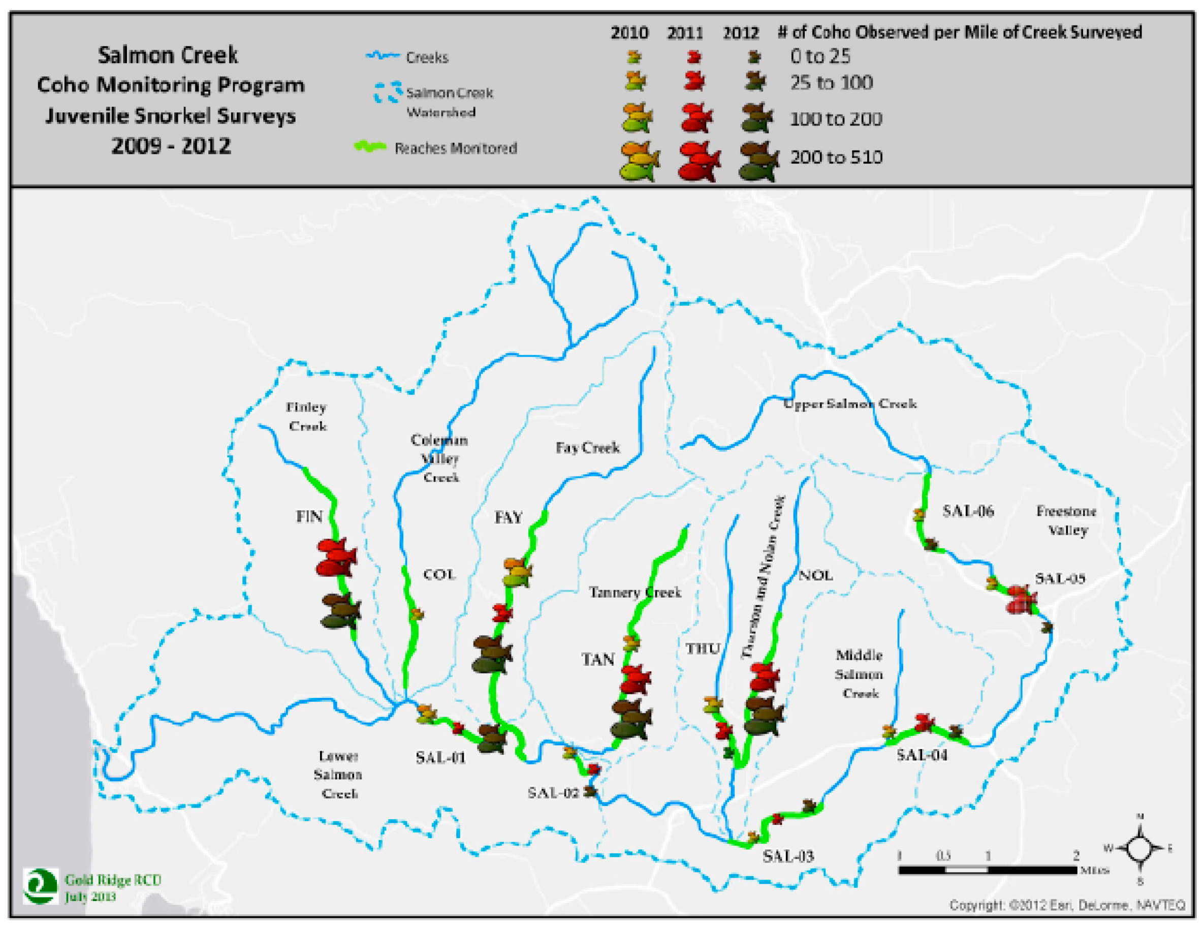
In Salmon Creek, some residents, environmental consultants and the Gold Ridge RCD observe and count salmon. Creek walkers monitor on their own or a neighbor’s property. They time their walks to take place after large rains to look for spawning adult salmon, and also visit periodically during the summer to check refuge pools for juveniles; ranchers may observe salmon while checking on pumps or fences after storms. Some residents log fish counts by species and location, and note the number of minutes spent surveying. They may report to RCD or university scientists and their neighbors by telephone or email. Consultants who work locally in habitat enhancement sometimes undertake their own snorkel surveys for juvenile salmonids or observe spawning adults while conducting project-planning visits. For three years after the release of captive broodstock coho into the watershed in 2008, the Gold Ridge RCD conducted winter spawning surveys and summer snorkel surveys under contract from the National Marine Fisheries Service (
Figure 3). They recorded observations on data sheets, tracking the observer; the exact location of spawning fish and redds; the size, sex, species, and their confidence in identification; the air and water temperature; and characteristics of the pools including the presence of large woody debris and size of gravel. The length of stream surveyed varied among years based on access agreements with landowners. As of 2013, the Gold Ridge RCD no longer received funding to monitor or aggregate fish count data, and thus lacks staff time to enter volunteer observations and create maps and reports. Watershed council members repeatedly expressed frustration that Gold Ridge has no funding for salmonid monitoring, and that coordinated monitoring of fish populations ended just four years after coho reintroduction began. The Gold Ridge staff are frustrated by the lack of funding, which they see as emblematic of state and federal agencies’ dismissal of the creek as potential salmon habitat. The agency continues to apply for funding and one Gold Ridge biologist does occasionally conduct snorkel surveys on her own time.
Drawing on local residents’ salmon observations would be one way to continue monitoring in the absence of funding, but several barriers limit the transfer of fish count information from residents to agencies. Several agency biologists expressed doubt that residents could accurately identify and report salmonid sightings. The Gold Ridge biologist also reported that some creek walkers, agricultural landowners, and consultants are unwilling to fill out data sheets and leave flags marking the location of fish and red sightings. Watershed council members mentioned that it often takes months for agency and academic scientists to aggregate, analyze and release spawning data, and that these delays decrease their interest in collecting data for agency use. After discussing these issues during the first collaborative science workshop, the Salmon Creek Watershed Council and I decided to organize wet-dry mapping surveys that incorporated juvenile fish data. During these surveys (described in more detail below), citizen scientists noted the presence of fish, refuge pools, springs, and woody debris. In addition to local residents, Gold Ridge and state and federal agency employees volunteer for wet-dry mapping shifts.
Sidebar for
Figure 3: Across all spawning surveys they conducted in Salmon Creek 2011–2012 and 2012–2013, the RCD visited each of twelve reaches 1.5-times, on average. Because of their many other responsibilities, access issues, and the need to coordinate with volunteer assistants, these visits sometimes missed the peak spawning period after each storm, and did not capture each spawning period on each reach. I volunteered with the RCD for spawning surveys in 2012–2013, and conducted my own spawning survey in 2014–2015. On several occasions, we walked a creek when flows were too high and muddy to observe fish clearly; on others we missed the peak spawning period because of the Christmas or New Year holidays. In contrast, creek walkers and riparian landowners reported visiting their study stream several times after a storm, and were thus more likely to observe spawning events. However, each creek walker only surveyed the one or two creeks on their property, and some surveyed only short (less than 1 km) reaches. Only the RCD aggregated data collected on multiple tributaries and made it available to other agencies and to the general public. They report the number of fish per tributary (rather than per parcel) in order to accommodate landowners who did not want state or federal regulators to know that endangered species were present on their property (
Figure 3).
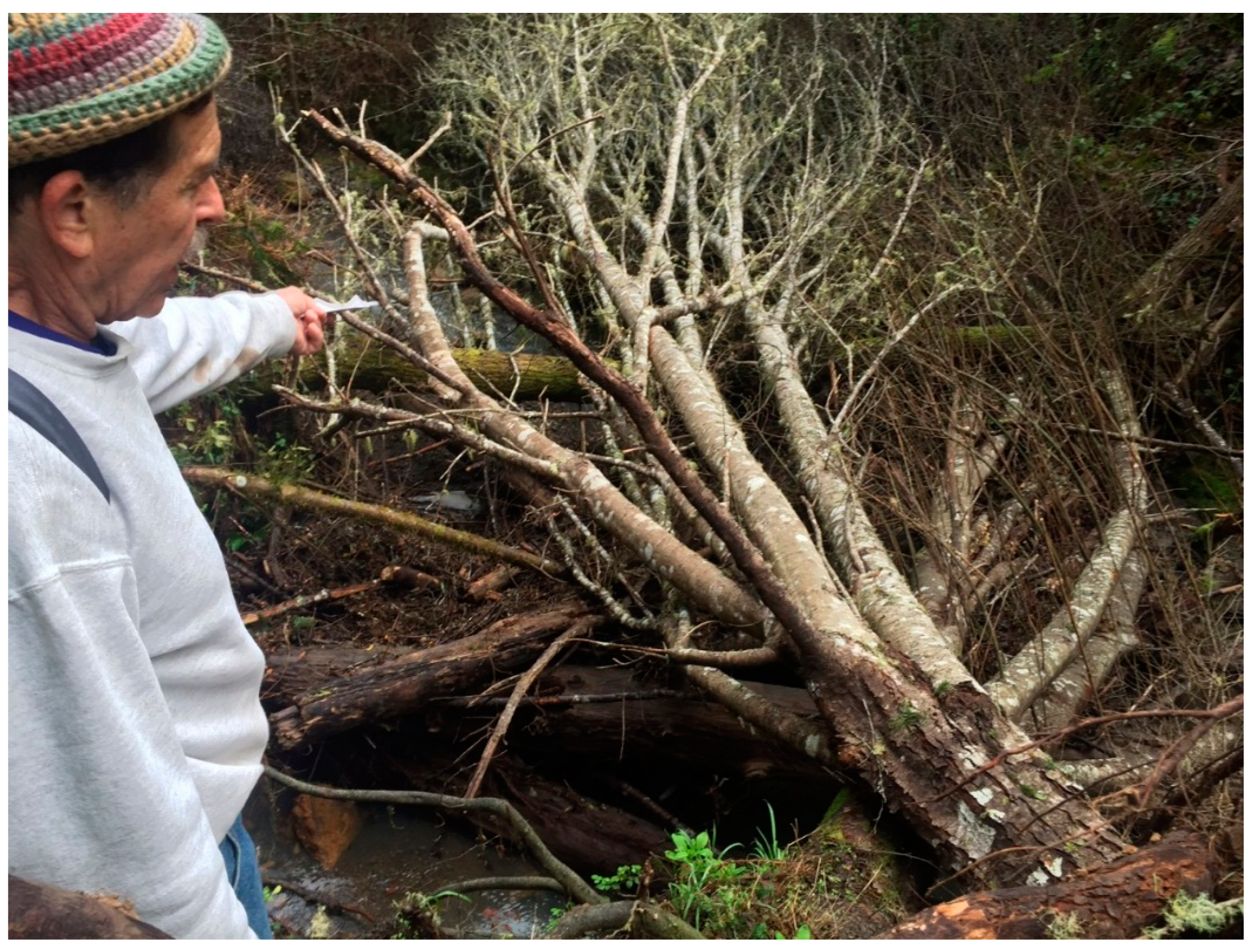
Sidebar for
Figure 4: After the first big storm of 2015, I received a flurry of phone calls and emails. Biologists at the Gold Ridge RCD, the California Department of Fish and Wildlife, the Russian River Captive Broodstock Program, and a local consulting biologist wanted to know of any sightings and coordinate surveys. A watershed council citizen scientist reported that flows were still high and turbid, and that they had seen no fish. A local resident and self-described creek walker reported seeing ten large steelhead leaping over a log he’d thought might block passage. He had made detailed notes on their number, size and behavior, and their degree of shimmer. The next day, he and I hiked down a precipitous trail through cut-over redwood forest to the channel-spanning log he called “steelhead city’’. Within thirty minutes we observed several carcasses and a male and female coho salmon on a redd, identifiable by the bright tags affixed through their dorsal fins at the hatchery where they had spent their lives until traveling by truck to the mouth of Salmon Creek for release.
4.2. Monitoring Groundwater via Wells and Springs
Throughout the watershed, water users are receiving signals—decreased rainfall, wells and springs that dry earlier in the season—and responding to these signals drilling new wells, tapping new springs, banding together with neighbors to monitor aquifer levels. Residents in the Salmon Creek watershed monitor their own wells and springs, and almost universally maintain rain gauges. Many regularly share rainfall data informally by phone with neighbors, and some keep detailed records for their own use or contribute to the Community Collaborative Rain, Hail, and Snow network (CoCoRaHS), a national citizen weather monitoring network (cocorahs.org). People who rely on spring water for domestic supply typically keep detailed records, while those with springs on their property who rely on bore wells do not, and most people didn’t consider spring flow proprietary data. On the other hand, people consider well data privileged information and rarely share it with officials or their neighbors, since knowledge of failing wells can lower their property value. However, during the extraordinarily dry year of 2014, when several wells and springs dried up for the first time in living memory, several residents formed collaborative well level monitoring effort, with one neighbor measuring static water levels at five adjoining properties at monthly intervals.
On the whole, residents use low-tech methods to monitor wells and springs: static measurements using homemade devices, watches, and mayonnaise jars and paper record keeping are the norm. Residents used manufactured rain gauges and followed established agency methods for siting gauges and recording rainfall (e.g., installing the gauge in an open area and checking and emptying it at the same time each day). These methods are equivalent to methods that government agencies use to gather point data on rainfall, groundwater level and springs, and in some cases provide sufficient resolution to calculate aquifer characteristics.
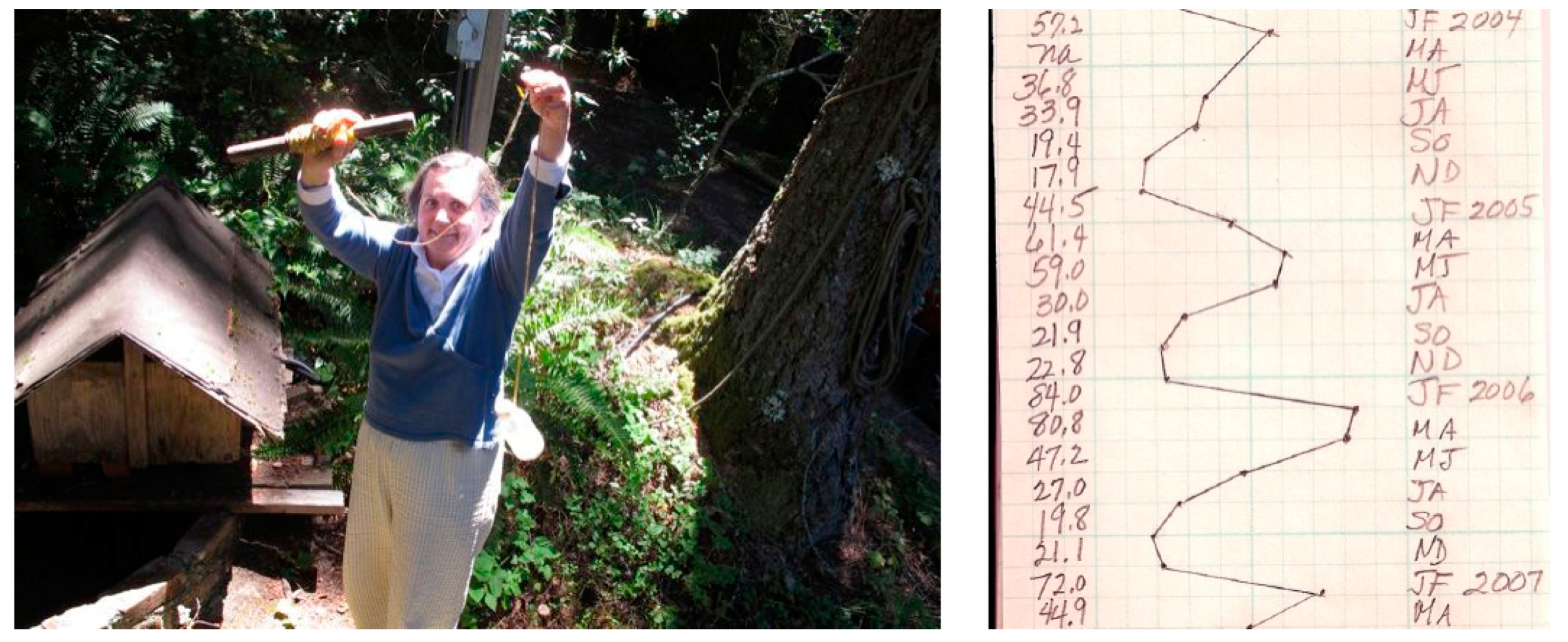
Sidebar for
Figure 5: One resident with an open well keeps detailed records going back two decades, making hand-drawn plots of rainfall and well levels at monthly intervals. Through these records, she had determined that the transit time (the time for water to reach the aquifer feeding her well) was sixty days. She presented these records at a collaborative workshop I organized, where an agency scientist asked if he could install a sonde to measure pressure, conductivity, and temperature at half-hourly intervals. She agreed, and two seasons of data confirmed the trend her analysis had measurements had identified.
Compared to U.S. Geological Survey monitoring programs in the nearby Sonoma Valley, there is little sharing of groundwater data in the watershed, and not enough wells are measured to allow aquifer delineation, track infiltration rates, and monitor seasonal changes in groundwater levels. I see two ways to increase monitoring and coordination. One way would be through collaborations between residents and Resource Conservation Districts that would install continuous water level loggers in a larger number of wells, with disclosure agreements regulating how the resulting data would be used. Salmon ‘safe harbor’ agreements, which release landowners from liability for salmon mortalities as long as they follow specific management practices, could also alleviate landowner resistance to monitoring; such agreements are in development in the Russian River Basin. Resident- agency collaboration could be expanded in rainfall monitoring as well, through enrolling more rainfall monitors in CoCoRaHS. This approach would require a higher level of trust between property owners and agencies that hold the data, such that residents were assured that county or state water agencies would not use the data to limit their ability to pump water, tap undeveloped springs, or drill new wells in the future. Given the mistrust that many residents expressed towards the county and regulators, and the expanded authority that new California groundwater monitoring requirements give to the state to regulate groundwater levels, this approach seems unlikely to be adopted widely.
4.3. Mapping Wet and Dry Stream Reaches
In 2013, I began this wet-dry mapping initiative in the watershed, modeled on an approach used by the Nature Conservancy on a trans-border reach of the San Pedro River in Arizona, USA and Sonora, Mexico [
72]. My goal was to track annual variation in the extent of wet and dry reaches at the end of the dry season. With several years of data, we could then identify reaches that always went dry, sanctuary reaches that always remained wet, and intermediate reaches where streamflow enhancement could increase the extent of high-quality habitat. The watershed council wanted to shift its monitoring efforts from monthly water quality sampling, which required finicky calibration of a failure-prone device and generated data that was not being used to inform management. Reach captains (local stream side landowners who knew adjacent landowners) coordinated access, while I tracked volunteers and assigned them to a reach, conducted a training in the method, entered the data, and created GIS maps to visualize it. In 2014, I asked watershed council members to partner in organizing the effort, to build their capacity to continue it in the future and to engage their local knowledge of social networks and technical capacity to improve the mapping process. In 2015 and 2016, the watershed council coordinated all of the surveying and data entry.
In contrast to salmon counting and water source monitoring, the wet-dry mapping project was an entirely new method that I, an academic outsider, introduced from scratch. However, it drew on existing creek walking and stream inspection practices discussed above, with some landowners volunteering to walk their own section of creek rather than enlist volunteers to do so. The initiative brought together local knowledge networks of local residents affiliated with the watershed council, independent biological consultants, and the Gold Ridge RCD. These different actors have non-overlapping networks; due to past conflicts, some landowners will allow the RCD, but not the watershed council to access; some will allow their neighbors or biologists they know personally to access, but not either group; and some will survey the stream themselves rather than allow any outside access. Some watershed council members who are relative newcomers to the area got to walk stream reaches for the first time, and met and interacted with agricultural landowners they knew by sight but had rarely talked to. The mapping walks also provided opportunities for residents to interact with agency and biologist volunteers, sharing local knowledge of streams and land use and expert knowledge of fish and other species. In the second year, several volunteers said they wanted to go out with the National Marine Fisheries Service biologist volunteer in order to learn more about identifying fish and their habitat requirements.
The data processing and visualization effort revealed technological and capacity barriers to continuing the effort once I moved on. Several members of the watershed council are skilled in data management, and developed procedures to streamline data entry in 2014. Although this step was time consuming, the volunteers thought that with teamwork, it was not too onerous. However, the use of GIS to visualize the data is a technical barrier, as the watershed council members have neither the software nor expertise to manipulate the data in GIS. We are currently collaborating with University of California Berkely researchers to develop a web-based visualization protocol that accepted spreadsheet data as an input, and allowed users to compare streams between years, calculate summary statistics, and print custom maps. Such an interface could be used in other watersheds and could be configured to accept input from GPS-enabled smartphones in areas where topography and tree cover allows those devices to receive a GPS signal. (This is not the case in most parts of Salmon Creek).
4.4. Seeking Common Waters: Different Perceptions of Water, Salmon, and the Watershed
In interviews and the workshops, I found that while scientists and local residents agreed that water scarcity was a key concern, they cared about different dimensions of water scarcity. Many biologists believed that stream disconnection into isolated pools caused juvenile salmon mortality, but did not know whether lack of food, lack of oxygen, high temperature or predation killed the fish; they were also concerned with fine sediment and nutrient runoff and lack of complex stream habitat that affected spawning success. Rural residents and agricultural users were primarily concerned with protecting groundwater from depletion by new wells or drought, and/or in avoiding regulation under new statewide groundwater rules. Some scientists are also local residents, some agriculturalists have scientific training, and nearly all residents express support for recovering salmon from the brink of extinction, complicating a neat division of participants into stakeholder groups.
In addition to spawning the wet-dry and well monitoring projects described above, the workshops seem to have had other impacts on relationships among participants, though these are harder to evaluate. The watershed council and a local land trust asked me to facilitate an annual workshop after attending the first one, and helped with organization; many agency and watershed council participants in the first workshop attended the second. Watershed council members also sought stronger collaborations with UC Berkeley, co-mentoring an undergraduate student who conducted archival research on land subdivision for their watershed timeline, and coming to Berkeley to meet with my faculty collaborators. But to my knowledge, none of the agencies have pursued substantial new engagements with local knowledge holders, nor sought to incorporate residents’ own measurements of rainfall, springs, well levels, or salmon counts. The Department of Fish and Wildlife has little presence in the watershed; the Gold Ridge RCD is currently monitoring individual parcels where they are conducting habitat and streamflow enhancement projects, but this relationship is a consultative one, with landowners granting access and expert biologists conducting species surveys and water quality monitoring. The UC Cooperative Extension wet-dry monitoring efforts in the adjacent Russian River basin is similarly consultative, although focused on ongoing monitoring of established study reaches rather than post-project monitoring of individual parcels.
One important limitation of this collaborative was the absence of tribal members and representatives of the Confederated Tribes of Graton Rancheria, in whose traditional territory the Salmon Creek watershed lies. This implicit exclusion perpetuates narratives, dominant in California and through much of the U.S., that Native Americans have vanished or have ‘lost their traditional ways’. This narrative, as many indigenous scholars have noted, in turn justifies the continuing occupation of unceded tribal lands and the destruction of lands, waters, and species that are necessary to fulfill treaty rights and or ongoing cultural survival [
73,
74]. Dakota science studies scholar Kim TallBear argues that scientific practices often re-inscribe narratives of indigenous disappearance, but also points out that new agreements governing researchers’ terms of access to blood, DNA, and other biological matter challenge this narrative [
75]. She works with genomic scientists to create research and co-authorship agreements with tribes and First Nations. Following that model, I tried to consult with Graton Rancheria officials, and failed to make contact.
(Sidenote: Early in my research, I met with Peter Nelson, a UC Berkeley graduate student in Archaeology and a Graton tribal member collaborating with the tribal government on research in nearby Tolay Lake, about how to best reach out tribe about possible collaborations. As he suggested, I reached out to the Natural Resources Department staff explaining my research interests, and also invited several tribal employees to speak at the first Collaborative Research Workshop. I received no response to this or subsequent inquiries, and eventually conducted my research without tribal collaboration. When I spoke to Nelson about this later, he brought up structural issues—the recent reinstatement of tribal recognition, the tribe’s limited budget and staff and focus on health and economic development—that limited the tribe’s ability to participate in salmon recovery and other regional natural resource governance processes. My reflections on this failed consultation process, and its implications for my research within a settler-colonial context, are part of a forthcoming collaborative paper on research practices in and with indigenous communities).
I continued to raise the issue of tribal participation in the collaborative process in public forums and in one-on-one interactions with my non-indigenous collaborators. On the whole, my interactions with agency, independent, and citizen scientists suggest that the narrative of the vanished Indian is pervasive in this region. Several residents showed me shellmounds or arrow points they had found, and many were familiar with anthropological stories of Pomo use of fire to maintain grasslands and riparian travel corridors. But when I asked whether they had made any attempts to work with local tribal members, or whether they thought that the tribe should have a stake in decision-making, only one person (of more than 50 respondents) responded ‘yes’. This person, an ethnobotanist and historian, had conducted interviews with several local tribal members, and compiled oral histories and historical documents into an eco-historical analysis. Many others, however, believed that local tribal members had ‘lost their culture’, had to re-learn their traditional ways from anthropologists, and thus had no cultural or territorial claims that would give them standing to co-manage private lands in the area.
Given these responses, I conclude that settler descendants in this region, scientist and resident alike, lack historical understanding of tribal sovereignty and treaty rights and do not see salmon and watershed recovery work as a processes for recognizing and materializing those rights. Even if tribal members or leaders were included in the collaborative process, it seems likely they would be considered as just another special interest group, rather than as representatives of sovereign nations with government-to-government status. Nor is there a mechanism for the considering the perspectives of farmworkers or other non-English-speaking residents in watershed governance. The watershed council has been successful in disseminating information and gathering responses from poor white residents, but much work remains to be done in pursuit of environmental justice in this case.
5. Discussion: Towards New Cultures of Water and Science
Now, I turn from the case to its implications in two dimensions: first, for ‘natural resource’ fish and wildlife and environmental/land-based governance and, second, for actual streamflow in Mediterranean climates. The first relates to Mediterranean water policy more broadly as it implicates variability and the particular institutions that have grown up to regulate and govern water. The second relates to the actual flows and ecological responses.
5.1. New Science to Support Flow Re-Allocation in Mediterranean Climates for Salmon Benefit
Because of inter-annual variability in flows in Mediterranean streams, sustaining their salmonid populations will require different water management strategies for wet and dry years. Deitch et al.’s hydrologic analysis of the recent drought shows little impact of streamflow on over-summer salmonid survivorship in wet and average years, even in intermittent streams [
33], though research by Grantham et al. [
66] suggests that higher flows would likely yield higher rates of survival. This research demonstrates that residents and managers need a way to sense dry years and to anticipate the harshness of drying early in the season, so that they can implement stricter conservation measures. Decentralized storage in ponds and tanks can reduce dependence on aquifers and springs, and target emergency ecological flow releases to ecologically important reaches [
76]. Drought response strategies, whether coordinated by agencies, Resource Conservation Districts, local residents’ groups or collaborative bodies, will need adapt quickly to drought conditions and to keep water in the stream for fish while safeguarding essential human uses.
Where human ground- and surface water diversions accelerate seasonal stream drying, re-allocating these waters will be necessary in order to maintain streamflow, preserve crucial summer aquatic habitat, and facilitate water storage and transfer from human to ecological systems. These re-allocations will create, in effect, new cultures of water use. But how will these re-allocations be accomplished? The strategies will necessarily depend on existing regulatory, social, cultural, and political contexts. For example, in Salmon Creek, few large surface water diversions exist, and enforcement agencies do not monitor salmonids. Therefore, a ‘take’ (killing) of endangered salmonids under the Endangered Species Act (ESA) would be difficult to identify, and still more difficult to attribute to a single landowners’ stream pumping. In the groundwater realm, the county has not limited the drilling of new wells, and the state does not consider the basin significant in terms of the Sustainable Groundwater Management Act, so it has not been included in groundwater planning processes. In short, few regulations exist, no agencies collect baseline data on residential or agricultural water use, and agencies lack resources and, in the case of the county, the will to enforce a moratorium on new wells. Given this regulatory climate and local residents‘ resistance to regulation, the “Safe Harbor for Salmon” agreements in development between the National Marine Fisheries Service (NMFS) and Russian River landowners are a promising first step. In this framework, landowners agree to protect riparian areas and limit their diversions to an agreed-upon threshold; in return, NMFS waives any fines for ‘take’ (salmon mortality) under the ESA. In a counterexample, the Washington Supreme Court ruled in 2016 that counties must not issue new permits for wells in basins that have been closed to new water rights to protect streamflows for salmon [
77]. Such strong regulations are currently almost unthinkable among California instream flows stakeholders, but perhaps not for long.
Citizen science and local citizen groups (including watershed councils, granges, and agricultural associations) can play an important role in planning, implementing, and monitoring water storage, aquifer recharge, and habitat restoration projects, but these voluntary approaches can only go so far. Strong regulatory frameworks and enforcement provisions are also needed, as they motivate reluctant parties to reconsider their land- and water-management practices. New regulations will ideally be crafted with the participation of local landowners, tribal natural resource departments, agency scientists, and academic researchers. However, such collaborative efforts will need to be coordinated by a new or existing institution that has the capacity, expertise, and trust of all parties. Candidate institutions include extension or University ‘science shops’, new divisions within federal or state agencies, or independent nonprofit citizen monitoring groups such as the South Yuba River Citizens’ League. Such deep and ongoing collaboration is also necessary for monitoring, data analysis, and enforcement: for citizen science data to be useful to either local landowners or agencies in informing management, the data needs to be available, and people need to be able to access it readily, in a range of formats, including online and in paper maps or reports.
For example, riparian landowners typically own large parcels and often rely on wells adjacent to streams that may be connected to the stream directly, or may intercept subsurface flow that would have otherwise contributed to base flow. These landowners are typically agriculturalists who rely on a mix of water sources—wells, springs and agricultural ponds—for household, home garden, and stock use (there is very little irrigated agriculture in the watershed). Several of these landowners experience water scarcity in drought years. The impact of near-stream groundwater pumping and riparian diversion is easily measured with pressure transducers; this data has been used for exploratory and regulatory purposes by the National Marine Fisheries Service in the Russian River Basin. Because the legal status of shallow groundwater diversions is questionable, many riparian landowners are unwilling to allow agencies access to continuously monitor streamflow levels because they fear that the National Marine Fisheries Service could use the data to levy fines for ‘take’ (inadvertent killing) of endangered steelhead and coho.
However, some landowners have been willing to allow the Gold Ridge RCD to monitor stream and pond conditions as part of a project to install large rain tanks and off-channel ponds to increase water security and eliminate summer water withdrawals. As of 2016, four ranchers, seventeen residential users, and the Bodega Volunteer Fire Department have collaborated with Gold Ridge to install rainwater storage to increase water security and eliminate summer pumping from the creek. These projects typically involve a ten percent cost share by landowners and are sized to capture all of the water they require for dry-season operations. In exchange, landowners agree to refrain from pumping from streams or near-stream wells during the summer months, and to allow streamflow monitoring for several years after implementation. These projects have been partially funded by National Marine Fisheries Service and the California Department of Fish and Wildlife because of their salmonid habitat benefits.
5.2. Implications for California Water and Salmon Governance, Science, and Monitoring
Through ethnographic and participatory research conducted while engaged in these diverse on-the-ground projects, I found a commons imaginary emerging organically as different people came together in field exercises and annual workshops to discuss their goals, methods, challenges, and limitations. Because of variability in Mediterranean climates, human users of water face scarcity in dry years even without accounting for environmental flows. State water planning documents and local communities have a desire to protect fish, via environmental flows, while continuing to divert water to sustain human livelihoods. However, the policies to do so—the co-equal goals specified in the Bay Delta Conservation plan and the National Marine Fisheries Service recovery plans for coho, steelhead, and Chinook salmon—have so far failed to banish the threat of extinction.
On California’s North and Central Coasts, local and tribal organizing, monitoring, and restoration actions have been critical in protecting remnant populations and pushing state and federal recovery efforts. In Salmon Creek, the Mattole River, the Klamath River, and in countless other watersheds, people have made a commitment to salmon, and reaffirmed this commitment year after year via salmon surveys, fry rearing, water storage, road decommissioning, and timber management efforts. My research shows that these face-to-face encounters with other watershed residents and with the fish themselves fosters different environmental imaginary than abstracted urban notions of wildlife conservation [
78]. In this imaginary, which I call the multispecies commons, people see fish as simultaneously an economic good (via commercial and recreational fisheries), a cultural resource (via subsistence fisheries and cultural connections to salmon), and as moral beings that deserve enough water to survive. They value salmon and steelhead’s actions that enhance multispecies connectivities, via their role as food for other species and bringers of nutrients to terrestrial landscapes. As members of a multispecies commons, these rural residents devote time and resources to community organizing, water conservation, habitat restoration, and citizen science. Local salmon culture is passed onto newcomers via watershed council outreach events and publications, and informally in conversations at the bar and the coffee shop. In this region, categories are slippery. Some farmers formerly fished commercially or for subsistence, some former fishers are now scientists, and many scientists are also local residents and water users. These slippery categories mean that statewide conflicts that pit fish against farms, or farmers against scientists, are not playing out here as much.
For all of these reasons, these new imaginaries have created a new sense of ecological possibility in the Salmon Creek watershed, one that is reinforced by rebounding salmon runs. Local residents, some of whom are also scientists, challenged state agencies’ claim that Salmon Creek contained no viable habitat, and made alliances with consultants, local agencies, and academics (including me). We collaboratively produced science that state and federal agencies then used to redraw maps of suitable coho habitat, and to justify funding ongoing monitoring and supplementation. These actions, too, increased residents’ sense of renewed ecological possibility, as they reported in workshops and interviews.
These new imaginaries, are all well and good, but how can they inform management and science? Scientists and water users agree, broadly, that to increase salmon populations, tributaries require more and longer summer flows, especially in drought years. Efforts are now focused on augmenting summer base flows via a combination of reduced pumping, enhanced groundwater recharge, and in-stream water storage using beaver dams or human-built analogs [
79]. Citizen science and tribal science can contribute to monitoring these efforts, filling gaps left by other institutions. As my case study shows, this expanded participation brings an opportunity to conceive of scientific research differently, iteratively posing questions that result in more policy relevant goals.
Another way to increase monitoring and coordination would be for residents themselves to expand their well monitoring efforts, without necessarily sharing that data with government agencies. One such effort began in 2014, when a group of five neighbors on a water-scarce ridge in the Salmon Creek watershed started measuring their well levels monthly and sharing the data among themselves. They hope to use the data to attract funding for rainwater harvesting and recharge projects. This effort is similar to a voluntary monitoring program in the Scott Valley in Northern California. There, ranchers monitor levels at more than 100 agricultural wells and have used that data to drive regional groundwater modeling in collaboration with UC Davis hydrogeologists [
80], and to evaluate instream groundwater recharge structures modeled on beaver dams. This ability to control the raw data, and to determine when and how it is shared, may be attractive to Salmon Creek residential landowners wary of county and state regulation.
6. Conclusions: Watershed Collaborations in Multispecies Commons
Where salmon hover on the cusp of extinction, some scientists and people who live along salmon-bearing streams seek new collaborations. Agencies, tribes and watershed councils commission competing studies to tease out links between human use of land and water, global oceanic cycles and the precipitous decline in salmon populations [
81]. Tribal resource managers turn to ecological models to validate traditional knowledge in the eyes of state fisheries boards [
82]. Scientists enlist commercial fishers and seals fitted with pressure and salinity sensors to study ocean conditions [
83]. Hydrologic modelers turn to long-time ranchers' expert opinions to condition model predictions of where streams dry up (D. Hines, National Marine Fisheries Service, personal communication, 21 March 2011). Ranchers import beavers to build dams and raise water tables [
84]. These watershed collaborations begin to transcend boundaries of human institutions, scientist/lay person and even species.
To understand watershed collaborations, it is not enough to discuss what projects scientists and others pursue in the name of salmon recovery. It is also important to look back at how scientific knowledge shaped earlier U.S. projects to tame rivers and harness their flows of water, power and fishes for particular political and economic ends. Scientific practices in disciplines of engineering, social science, forestry, geology and hydrology coevolved with, and indeed were instrumental to, the project of Manifest Destiny. Legacies of Manifest Destiny thinking are sedimented into infrastructures, such as dams and aqueducts and land use conversion to logging, agriculture and urban development, while the practice of dismissing indigenous and traditional land management practices infuses water, forest and fisheries governance institutions.
Now, some bottom-up and collaborative efforts to rehabilitate ravaged land- and water-scapes are turning scientific methods to new uses. These appropriations, hybrids and reworkings of scientific practice by Native American tribes, rural communities and urban environmental groups (among others) are transforming the practice of riverine science and prompting renegotiations of what kinds of knowledge should inform environmental governance. Some of these new configurations ultimately challenge legacies of Manifest Destiny thinking by transforming legal doctrines, dismantling dams and levees and inspiring new cultural water use practices.
These collaborations only persist insofar as they build trust needed to sustain and develop new imaginaries, new cultures of water and land relations. The Salmon Creek collaboration enhanced trust and understanding of others’ imaginaries by different knowledge actors, but has not persisted in the same form since I ended my formal engagement with the process. However, collaborative participants have taken on some of the science work I spearheaded: the watershed council is continuing to collect wet-dry data; the California Department of Fish and Wildlife is conducting juvenile salmon surveys on several Salmon Creek tributaries; and local residents are monitoring and sharing data about well levels. Wet-dry mapping and agency outreach events bring the participants together, though perhaps in a less focused way than at the collaborative workshops I organized. What has not persisted is the coordinating role I played, because agencies and local residents alike lack capacity and the transdisciplinary synthesis of hydrological and ecological data. I have continued annual fish and water quality monitoring in my study reaches and, in collaboration with my students, will continue to explore ecological, social and institutional aspects of salmon recovery in the watershed. Key questions in this ongoing research include how trust evolves over time and in the face of emerging regulatory regimes, which citizen science projects sustain participants’ interest, whether citizen science data comes to play a larger role in agency science and whether self-regulation and commons governance regimes prove effective in recovering salmon and sustaining streamflows in drought years.
This paper has investigated how watershed collaborations transform scientific practices, environmental subjectivities and trans-species alliances, using Salmon Creek as a case. From the outset, I sought to undertake research as a collaborative process, bringing together local residents, agency representatives, grassroots groups, independent scientists and tribal representatives. By drawing the diverse ‘partial perspectives’ informed by their different situated knowledges into a lively composite, I have presented an approach wherein transdisciplinary research groups develop a set of research questions that addressed dynamic interactions among salmon, water and land use, livelihood and politics and to develop collaborative methods that bring together different scientific, indigenous and local knowledge to address questions of social and ecological concern to collaborative members.
In closing, I would like to extend the idea of watershed collaborations still further, by bringing in other species—beavers, salmon, redwood trees—into entangled and symbiotic relations with humans who manage waterscapes. In this view, through a process of engaging in stream monitoring or rearing salmon eggs in sluice boxes, humans recognize (to borrow Donna Haraway’s phrase), that “the partners do not precede their relating; all that is, is the fruit of becoming with” [
85]. Such collaborations may not involve government agencies or non-governmental institutions, yet still often reshape material-semiotic configurations “from below” as they discursively affect human practices of using water, stone, soils, plants and animals; or sometimes, concepts of humans as collaborators with other species, as situated within a reciprocal web of becoming, may filter into policy discourses or political debates. Such transgressive knowledge practices re-frame ecosystems as multispecies commons and emphasize interdependence rather than conflict between human and ecological needs for water and offer the best chance for advancing sustainability and equity among and beyond the human.


