Effects of Water Regime on Spring Wetland Landscape Evolution in Poyang Lake between 2000 and 2010
by
 , ,
, ,
Hailin You
1,2, 
Hongxiang Fan
2,
Ligang Xu
2,3,* ,
,
Yongming Wu
1,
Xiaolong Wang
2,
Lizhen Liu
1,
Zhong Yao
1 and
Bangyou Yan
3 1
Poyang Lake Research Center, Jiangxi Academy of Sciences, Nanchang 330096, China
2
Key Laboratory of Watershed Geographic Sciences, Nanjing Institute of Geography and Limnology, Chinese Academy of Sciences, Nanjing 210008, China
3
Office of the Mountain-River-Lake Development Committee of Jiangxi Province, Nanchang 330046, China
*
Author to whom correspondence should be addressed.
Water 2017, 9(7), 467; https://doi.org/10.3390/w9070467
Submission received: 25 April 2017
/
Revised: 5 June 2017
/
Accepted: 19 June 2017
/
Published: 27 June 2017
Abstract
:Water regime was one of the most important driving factors in the formation of wetland landscape and the growth and distribution pattern of wetland vegetation. Currently, research on the relationship between wetland landscape and water regime was mostly focused in autumns and winters in Poyang Lake, and lack of research in springs. Based on the nine high-resolution spring remote sensing images during 2000–2010, the classification characteristics of wetland landscape and spatial distribution pattern of vegetation and their succession trends in Poyang Lake were studied through quantitative interpretation technology and multivariate statistical analysis. Combined with water level fluctuations characteristics of the five monitoring hydrological stations (i.e., Hukou, Xingzi, Duzhan, Tangyin and Kangshan) at the Poyang Lake, the inter-annual and intra-annual water level variations of Poyang Lake were analyzed. The study was aimed to investigate the quantitative effects of water regime on the spring wetland landscape and spatial distribution pattern of vegetation and their succession trends in Poyang Lake. The results showed that: (1) the maximum scope of water levels of the five monitoring stations varied from 8.5 m to 13.57 m, and the water level of Poyang lake showed a downward trend, declining at an average rate of 0.16 m per year during 2000–2010; (2) the total area of the 10 types of the landscapes did not change significantly, which was always maintained at about 3026 km2 and the total area of vegetation coverage showed increasing trend during 2000–2010 in Poyang Lake, with a maximum area in 2008 and a minimum area in 2010; (3) The water level change was consistent with the area of the lake water, and was inconsistent with the areas of the mudflat, vegetation and land-water transition zone. The highest linear fitting degree with water level was the area of the land-water transition zone, followed by the lake water and vegetation. The results were helpful to further explore the eco-hydrology process and its trend at Poyang Lake wetland, a scientific reference for the maintenance of stable ecosystem functions of the seasonal freshwater lake wetland.
1. Introduction
Water regime is a major determinant of wetland landscape evolution and has been considered a driving factor of wetland ecosystems [1]. It has a great impact on spatial and temporal heterogeneity, composition, productivity, stability, and succession of wetland landscapes [2]. The effects of water regime on wetland landscapes have been investigated for decades. Water regime is a common and complex phenomenon, particularly in lakes, defined by magnitude, frequency, and duration, dominating the structure and function of wetlands in a lake setting [3]. Changing water levels are of particular concern because they are directly linked to commerce and the provision of lake wetland ecosystem services [4]. Take Poyang Lake in China as an example, the concerns of its water level fluctuations seem more intense, which has aroused widespread public attention during the past decade because the water level fluctuations are relatively large, with more than a 10 m difference between the lowest and the highest water levels. The impacts of the huge water level fluctuation further influence wetland landscape, especially on creatures in the short and long term. Poyang Lake, the largest freshwater lake in China, situated in the middle-to-lower reaches of the Yangtze River in Jiangxi province between 115°49′–116°46′ E and 28°24′–29°46′ N, is well known for its ecological importance as a dynamic wetland system. Poyang Lake is rich in biodiversity, with 102 species of aquatic plants, 122 species of fish and 300 species of birds [5], which is in the first batch of The Ramsar Convention List of Wetlands of International Importance [6]. It is mentioned that 95% of the Siberian crane, an very important species, is wintering in Poyang Lake in the world. Poyang Lake receives discharges from the Gan River, Fu River, Xinjiang River, and Xiushui River (“Five River”) and, in turn, provides discharges to the Yangtze River through Hukou County, Jiangxi Province. The water level fluctuates naturally with drought and wet cycles as well as seasonal, and monthly water level fluctuations are relatively large, with more than a 10 m difference between the lowest and the highest mean monthly water levels. It varies remarkably from several thousand km2 in summer to less than one thousand km2 in winter. There are five monitoring hydrological stations at the lake, which are Hukou Station, Xingzi Station, Duchang Station, Tangyin Station and Kangshan Station from the north to the south (Figure 1). The five monitoring hydrological stations record the water levels of its own respective jurisdiction in Poyang Lake each day.
Poyang Lake experiences a wet season in April each year, and reaches the highest water level in July, and still maintains a high water level through August and September, then declines stably into a dry season from October to March. Poyang Lake forms an alternating landscape with water and land in the transition periods between the wet season and dry season. The Poyang Lake wetland forms a heterogeneous landscape with rivers, lakes, and beaches [7]. Wetland vegetation is one of the most common landscape types, which is an important material basis for the biodiversity of Poyang Lake. The vegetation of Poyang Lake is abundant, with reed community, carex community, and a submerged vegetation community from the lakeshore to the middle of the lake along the elevation gradient. Poyang Lake provides a good example of when hydrological characteristics vary across space and where management strategies need to be carefully targeted.
Almost all wetland landscapes are affected by water level fluctuations in Poyang Lake. The temporal and spatial distribution of each landscape has changed a lot in the last decades under the influence of water level fluctuations. There are already many studies on the relationship between water regime and Poyang Lake wetland. Nõges and Nõges [8] stated that water level change was the most important factor influencing long-term changes in the status of a wetland ecosystem. Han et al. [9] showed that water regime was the most important factor affecting winter wetland landscape changes of Poyang Lake based on Landsat observations between 1973 and 2013. You et al. [10] used 16 high autumn resolution remote sensing images and reported that the classification characteristic of the wetland autumn landscape and its response to water level fluctuations in Poyang Lake. Previous studies revealed that the wetland landscape change was significantly different under different water levels, and the distribution area and distribution elevation of each landscape was also different [11]. Dai et al. [12] used Ecological Health Comprehensive Index to evaluate the health status of wetland vegetation and revealed the effect of hydrological process on the health status of the vegetation in Poyang Lake. The results showed that the hydrological condition in the rising season was a decisive factor for wetland vegetation and the high lake level in the rising season resulted in a small coverage area of the whole wetland vegetation. Research to date has primarily analyzed the response of wetland landscape and vegetation to the water regime in Poyang Lake to a certain extent, based on field surveys or laboratory experiments, focusing more on the autumns and winters rather than springs. In addition, how the variable hydrological regimes impact quantitatively on the wetland landscape and vegetation evolution need to be further explored.
Based on nine long-term remote sensing databases of Poyang Lake from 2000 to 2010, wetland landscape change and vegetation evolution under different water level fluctuations in spring was investigated. The hierarchical classification was used to interpret the remote sensing images and extract the information of wetland landscape and vegetation in Poyang Lake. Multivariate statistical tools were used to evaluate the relationships between water level fluctuation and landscape change and vegetation evolution. The main objectives of this study were (1) to further understand the effects of hydrological processes on Poyang Lake at large scales; (2) to investigate the spring wetland landscape change and vegetation evolution in Poyang Lake; (3) to delineate the landscape change and vegetation evolution with the water regime in springs, and (4) to identify quantitatively the impact on the distribution area of the spring wetland landscape and vegetation coverage in the Poyang Lake ecosystem. The results are helpful to supplement and perfect the dynamic characteristics of wetland landscape and its response to the water regime during a whole year in Poyang Lake to a certain extent, which can provide scientific references for rationally maintaining ecological balance and stabilizing the ecological service function of Poyang Lake wetland.
2. Materials and Methods
2.1. Data Preparation
Daily water level data (unit (m), Wusong datumn level) from 2000 to 2010 were collected at five hydrological stations (Hukou, Xingzi, Duchang, Tangyin, and Kangshan) of Poyang Lake. The average water level for the five hydrological stations for a given year was used as the Poyang Lake water level for that year.
A total of nine high-quality Landsat t TM/ETM+ images (Path/row: 121/40) of Poyang Lake in spring (from the March to May in south of China) from 2000 to 2010 were chosen, which coincided with the years of the water level data (Table 1). Images were downloaded from the Earth Observation and Digital Earth Science Center, Chinese Academy of Sciences. The Landsat images are Systematic Geocorrection products resulting from geometric system correction and atmospheric radiation correction.
2.2. Processing of Remote Sensing Images
The wetland landscape information in spring at Poyang Lake wetland was extracted from remote sensing images based on the spectral curve characteristics of different marks [13]. The process of processing the remote sensing images followed three steps: preprocessing, hierarchical classification and accuracy assessment.
Image preprocessing consisted of data import, registration, and spatial subset. On the basis of the geo-referenced Landsat images of Poyang Lake area, we applied ENVI 4.7 (The Environment for Visualizing Images version 4.7, developed by Exelis Visual Information Solutions, Colorado, United States) software for the map registration of the images through choosing the ground-control points. The root mean square errors in image registration were <0.3 pixel for all nine images during 2000–2010. We then selected a spatial subset to extract the images that included the scope of the whole lake area including the river, dam, grassland edge, etc.
According to the “Convention on Wetlands of International Importance Especially as Waterfowl Habitat” and the “Wetland classification system in China” [14], a classification criterion was established for the Poyang Lake wetland and adjusted by using field surveys. The hierarchical classification criterion of the study were made up of two levels. The first level consisted of water, vegetation, and land-water transition zone. The second level included ten types of the wetland landscapes, viz. deepwater, moderate-depth water, shallow-water, marsh, sparse-grassland, carex, canarygrass, reed, mudflat and bare-land. We calculated the Normalized Difference Vegetation Index (NDVI) using the calculation formula of NDVI = (NIR − RED)/(NIR + RED) [15] by ENVI 4.7 to obtain the vegetation coverage distribution.
Following field surveys of the distribution and structure of the landscape in the Poyang Lake region, typical landmarks were selected by fixed-point observation at the lake shore and by cruise-fixed-point investigation in Spring in 2010 at the lake surface. A standard error matrix, overall classification accuracies, and Kappa chance correction statistics were used for the images to determine the accuracy of the hierarchical classifications. Finally, the overall classification accuracy of the remote sensing images was more than 80% compared with the ground truth.
2.3. Statistical Analysis
The water level fluctuations of Poyang Lake, the spring wetland landscape and vegetation coverage and their change trends were conduced by trend analysis method through Origin 8.5 (OriginPro 8.5, developed by OriginLab Corporation, Northampton, MA, USA). The relationships between wetland landscape and water level fluctuations were analyzed by linear fitting with Excel 2007 (Microsoft, Redmond, WA, USA). Values of the coefficient of determination Adj.R-Square (R2) ranged from 0 to 1. The value of the coefficient of determination indicates the strength of the linear relationship between the variables, with large values indicating stronger relationships. A one-tailed test of significance was used to test the fitting results. The correlation analysis of the spring landscape and water levels was analyzed by Spearman Correlation with SPSS 16.0 (Statistical Product and Service Solutions version 16.0, developed by International Business Machines Corporation(IBM), Armonk, NY, USA.
3. Results and Discussion
3.1. Characteristics of Water Regime in Poyang Lake
The inter-annual water level fluctuations of the five monitoring hydrological stations from 2000 to 2010 are shown in Figure 2. We can see that the annual peak water levels of the five stations have no differences, with a maximum water level of 20.3 m at Tangyin station and a minimum water level of 20.14 m at Duchang station. However, both the annual lowest and annual average water levels of the five stations are significantly different (). The annual lowest water level is 6.63 m at the Hukou station in the north, and 11.75 m at the Kangshan station in the south producing a difference of 5.12 m between the two stations. The annual average water level is 12.42 m at the Hukou station, and 14.88 m at the Kangshan station, producing a difference of 2.46 m. Both the annual lowest and annual average water level show the same sequence from high value to low value, followed by the order of Kangshan > Tangyin > Duchang > Xingzi > Hukou, just the same as the geographical location distribution of the five stations from south to north. The water level of Poyang Lake was high during the flood season and decreased markedly in the dry season. Due to the seasonal water level changes, the lake water surface area expands and shrinks extensively from >3000 km2 in the wet season to <1000 km2 in the dry season [16]. The maximum scope of water levels of the five stations vary from 8.5 m to 13.57 m during 2000–2010, followed by the order just against the geographical location distribution of the five stations from south to north. The cause of the phenomenon is mainly due to the elevation gradient of the Poyang Lake bed. The elevation of Poyang Lake bed is different, and inclines from south to north. Bai [17] suggested that the elevation of Poyang Lake bed is 12.0 m in the south and about 1.0 m in the north, with a fall of 11.0 m. Therefore, the entire Poyang Lake surface is a horizontal plane, with relatively small water level differences across the lake in wet season. However, the lake surface inclines more sharply from south to north due to the elevation difference of the lake bed in dry season, in addition to the fact that the Poyang Lake water is discharged into the Yangtze River during that time [18,19]. The resulting water level gradient differences can be up to several meters among the water levels of the five stations.
Figure 3 presents the daily water level of Poyang Lake and its change trend during 2000–2010. It can be seen that the water level of Poyang lake shows a downward trend, with an annual rate of decrease in the average water level of 0.16 m per year. The reason may be caused together by global climate (i.e., the EI Niño phenomenon or La Nina phenomenon) change and anthropogenic activities. The anthropogenic activities, viz. sand mining, reclaiming farmland from the lake, and channel regulation of the lake region, have aggravated the incline phenomenon of Poyang Lake surface in the last few decades. These anthropogenic activities have increased the volume of Poyang Lake and lowered the elevation of the lake bed, consequently decreasing the water level of the lake, particularly the sand mining [20]. According to the statistics data, annually 4.5 × 10⁷ t sand, four times the amount of mean sediment deposition, is mined from the Poyang Lake for economic benefit. Because the sand mining region being mainly concentrated in or around the lake channel, the elevation of the lake channel will certainly be lowered, consequently lowering the water level of Poyang Lake. Guo et al. [21] suggested that the decreased water level of Poyang Lake was following from the operations of the Three Gorges Dam. Furthermore, the dam operations may even promote earlier dry season effects in Poyang Lake. However, the specific quantitative impacts of the Three Gorges Dam’s operation on the water level of Poyang Lake has yet to be further explored. The water level hydrograph has two forms, unimodal and bimodal water level hydrograph. The unimodal water level hydrograph is formed because flooding of the Five River is delayed in some years and coincides with early flooding of the Yangtze River. In other years, flooding of the five branches is early and flooding of the Yangtze River is late, then leading to a bimodal water level hydrograph. It is difficult to predict whether one given year’s water level hydrograph is unimodal or bimodal. Previous studies have reported that the number of years of bimodal water level hydrography are always more than those of unimodal in general in past years [10]. In this study, there is only the year of 2007 of the water level hydrograph is unimodal during 2000–2010, while the other of 10 years are all bimodal. Our findings are consistent with the results of the previous studies.
3.2. Classification Characteristics of the Spring Wetland Landscape in Poyang Lake
The spring wetland landscape has three categories (water, vegetation, land-water transition zone) and 10 subcategories (Figure 4) during 2000–2010 in Poyang Lake. viz. deepwater, moderate-depth water, shallow-water, swamp, sparse-grassland, carex, canarygrass, reed, mudflat and bare-land.
There are three types of water (deepwater, moderate-depth water, shallow-water), and five types of wetland vegetation (marsh, sparse-grassland, carex, canarygrass and reed), and two types of land-water transition zone (mudflat and bare-land). The habitat of the 10 spring wetland landscapes and their significances are shown in Table 2.
Figure 5 presents the distribution area of the landscape in Poyang Lake wetlands in spring during 2000–2010. We can see that the area of the each landscape is different every year. The area of the water is at a maximum except for the years 2001 and 2008, which are 87.40 and 143.60 km2 less than that of the vegetation, respectively. The area of the land-water transition zone is always at a minimum each year. The integrated factors of nature and humanity may together lead to this phenomena taking place. The area of the water is lowest in 2001 and highest in 2010. The area of the vegetation is lowest in 2010 and highest in 2008. The area of the land-water transition zone is lowest in 2010 and highest in 2010 and highest in 2004. Although the area of each landscape is different every year, the total area of the Poyang Lake wetland (the sum areas of the three landscapes) is almost the same, which is always maintained at about 3026 km2 or so in spring during 2000–2010.
3.3. Distribution Characteristics of the Spring Vegetation in Poyang Lake
Based on the remote sensing images, we have extracted the five kinds of the spring vegetation in Poyang Lake, viz. marsh, sparse-grassland, carex, canarygrass and reed. The growth scope and distributed elevation of the each type of wetland vegetation is different. The distributed elevation of the vegetation is mostly between 10–17 m [22], and in general followed the sequence of reed > carex > sparse-grassland > canarygrass > marsh from high to low. Thus, reed is the representative of highland-emergent aquatic plants, while canarygrass is the representative of lowland-emergent aquatic plant in Poyang Lake. The wetland vegetation is mainly distributed in the southwest, south and southeast of the Poyang Lake, while the northern distribution area of the lake is rather small (Figure 4), which is the overall distribution pattern of the wetland vegetation in Poyang Lake. The reason is that directions of the southwest, south and southeast are just the lake entrance of the “Five River”. The “Five River” discharges into the Poyang Lake from the south, east and west towards the north. Due to fluviation being stronger than the lake water influence, lots of sediment accumulates in the estuary, and then leads to production on a large-scale of estuarine delta wetland and a dish-shaped depression. Because of the effects of river flow and alluvium, lots of nutrients are brought onto the estuarine delta wetland and dish-shaped depression. It is just these nutrients to produce very fertile soils for growth of the wetland vegetation in the southwest, south and southeast of the Poyang Lake. Therefore, large areas of the vegetation are distributed in these places. While it is mostly hilly and mountainous in the north of Poyang Lake, the soil fertility is relatively low. Furthermore, there is less precipitation in the hills and mountains, both of which make it not suitable for the wetland vegetation to grow. Thus, there is less vegetation coverage in the north of Poyang Lake.
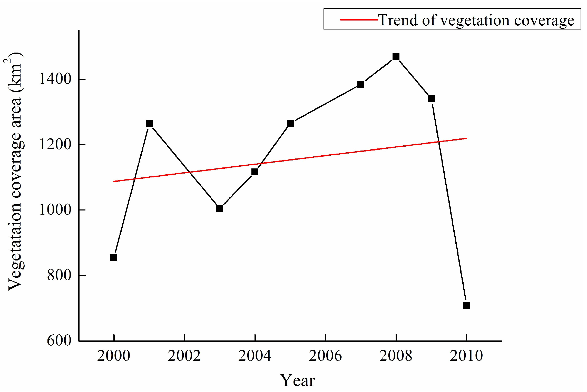
Figure 6 shows the statistical total area of vegetation coverage and its trend in Poyang Lake during 2000–2010. It can be seen that the total area of spring vegetation coverage is lowest in 2010 and highest in 2008. The change of vegetation area is in the pattern of rising and falling and once again. In the years of 2003 and 2010, the vegetation areas experienced a sharp decline. The degree of the decline in 2010 was greater than in 2003. In general, the spring vegetation area shows a increasing trend.
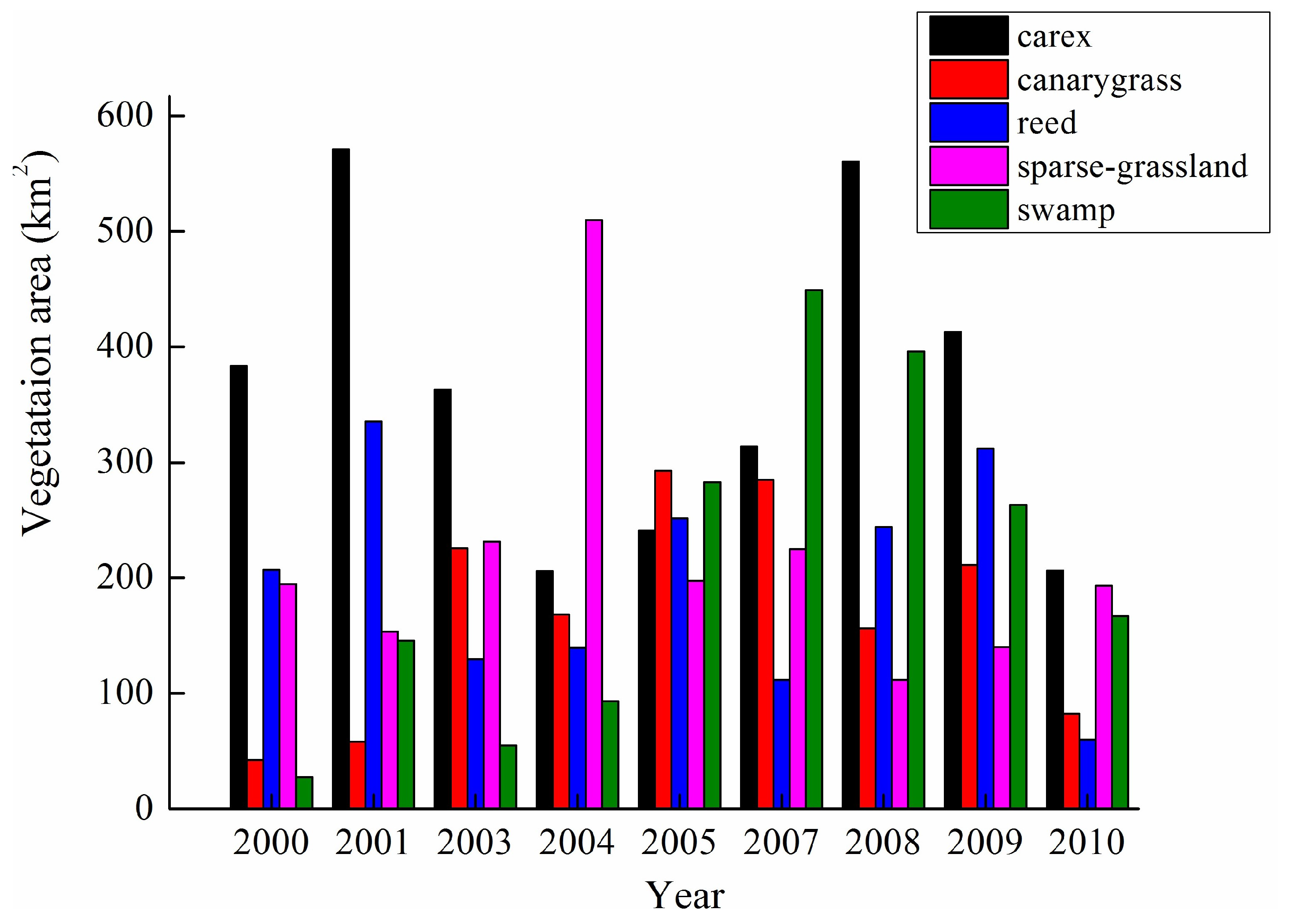
It can be seen that the area of the five vegetation types is different every year (Figure 7). Carex has occupied the maximum number of years (six years) in total in the area of spring vegetation, which are 2000, 2001, 2003 and 2008–2010. All of the swamp, sparse-grassland and canarygrass that have their maximum number of years are the same (one year), which are 2007, 2004 and 2005, respectively. The reed is not represented in terms of maximum number of years. This is mainly due to the abnormal water regime in recent years in Poyang Lake. It is just the abnormal water level that brings some adverse effects to the wetland vegetation, such as degradation of highland emerged plants, biodiversity reduction of land-water transition zone plant, decreasing area of submerged macrophytes and so on. Swamp and sparse-grassland have the minimum number of years in total in the area of the spring vegetation, both of which are three years. The carex is not represented in terms of minimum number of years. Previous studies [23] report that carex is the dominant species most widely distributed in Poyang Lake wetland. The carex cinerascens is the most common species in carex in the Poyang Lake region.
3.4. Dynamic Responses of the Spring Landscape to Water Regime
The distribution pattern of the wetland landscape is obviously affected by the water gradient in Poyang Lake. Each type of landscape occupies a specific water ecological space. The overall distribution pattern of the vegetation shows a strip along a horizontal line. As the lake bottom elevation and the corresponding water depth change, the wetland landscape produces a continuous change of vertical zonation. The landscape is followed by reed, carex, meadow, swamp, mudflat and water from the highland to lowland to the lake along the elevation gradient. Meanwhile, the landscape also shows patchy distribution on the beach due to the influence of the micro-terrain. Thus, the lake bottom elevation and water depth are the main two factors influencing the distribution pattern of the wetland landscape. Water level fluctuation is a comprehensive characterization of the lake bottom elevation and water depth, which has a great impact on the formation and evolution of the spring wetland landscape. Poyang Lake has especially experienced the phenomenon of “high water is not high, low water is too low” in recent years. This phenomenon results in the exposed time of the beach being an average of 1–2 months earlier than usual. Moreover, the exposed area of the beach has been greatly increased, furthering the change in landscape pattern in Poyang Lake [24]. For example, due to the earlier exposed time of the beach, some of the higher elevation of the reed meadow is degenerated into lower elevation of the carex meadow in the junction delta wetland of the Ganjiang Main-branch estuary and the Raohe estuary. At the same time, the carex meadow expands towards the lake [25].
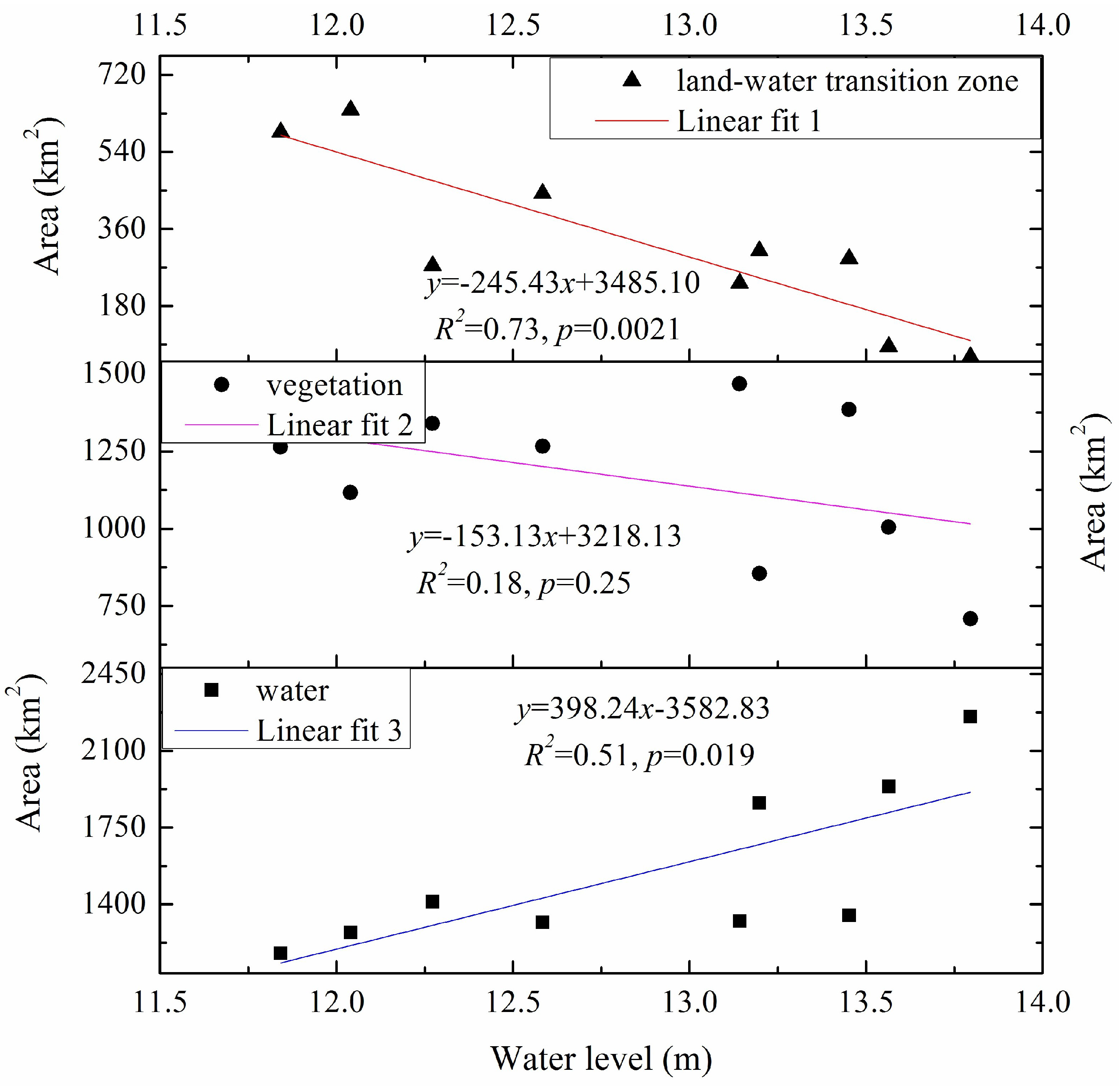
Based on the above analysis, our paper discusses the relationship between the distribution pattern of the spring wetland landscape and water regime combined with the spring water level fluctuation characteristics, in order to clarify the dynamic response of spring wetland landscape to water regime in Poyang Lake. Figure 8 presents the linear fits between the three types of the landscape and water level fluctuations in Poyang Lake. We can see that the water area has a good linear fitting degree with the water level (R2 = 0.51, p = 0.019). As the water level goes up, the water area increases; as the water level goes down, the water area decreases. Based on the seasonal water level changes, the lake water surface area expands and shrinks extensively from >3000 km2 in the wet season to <1000 km2 in the dry season, which forms a unique natural geographical landscape of “acting as a lake in high water level, and acting as a river in low water level” in Poyang Lake. When the water level rises, the lake water areas expands, resulting in the areas of the other two landscapes being reduced. Thus, the other two landscapes show an opposite trend to the water level. The land-water transition zone is next to lake water, which is much easier affected by the water level fluctuation. Therefore, the highest correlation between water area and water level was found in that region. (R2 = 0.73, p = 0.0021). The linear fitting degree of the land-water transition zone is higher that of the water area, mainly due to the topography of the lake bed. The water level is equal to water depth plus the elevation of the lake bed. When the lake bed is wide, then even if the water level goes up, the water area will not increase. The wetland vegetation is not flooded or completely submerged by lake water in the case of the low water levels. In particular, some vegetation (i.e., reed and carex) at a high elevation is even higher than the spring water level ranging from 11.84 m to 13.80 m. Under these circumstances, the water regime does not have too much effect on growth and distribution pattern of the wetland vegetation. The vegetation has a linear fitting degree of a (R2 = 0.18, p = 0.25) with the water level. However, as the water level rises to a certain height to flood or submerge the vegetation, the water regime has a great impact on the vegetation. Naumburg et al. [26] reported that low water level often leads to plant water stress and reducing live biomass, while high water level floods root systems and kills plants because most species cannot tolerate the associated low oxygen levels, particularly the lake wetland vegetation.
The correlation analysis between the 10 subtypes of the spring landscape and the water levels in Poyang Lake is shown in Table 3. Due to most of of lake water depth being more than 50 cm, deepwater is the main part of Poyang Lake, which shows a significant positive correlation with the water level. The mudflat is one main part of the land-water transition zone that is close to the lake water. As the water level rises, the mudflat is flooded by water; as the water level declines, the mudflat is exposed and expanded. Thus, the mudflat is has a very significantly negative correlation with the water level. The spring is from March to May in Poyang Lake, the time when the water level gradually goes up as a result of the discharge of the Five River and frequent spring precipitation in the Poyang Lake basin. People often call this time the “water-rising stage”, but the water level is not too high at this time. Meanwhile, groundwater depth is larger due to the precipitation. The reed seedling stage does not require much water as long as the ground surface is moist. In fact, reeds will not die, even if completely flooded for a one-week period [7]. However, reeds cannot withstand long-term flooding, particularly the reed seedlings in the wet season. The carex community differs from the reed community and experiences a “germination–growth–germination–growth” cycle (two life cycles) in a single year [27]. The carex turns green at the end of February and early March, completing the stage of vegetative growth during this first season, and enters the reproductive stage from March to April. The gradual inundation of the plant begins at the end of April and the plant is submerged by the end of May. Thus, the water level can not influence the growth of the carex much in the first life cycle. It is known that the plants of Poyang Lake are distributed throughout the entire lake, and the vegetation presents a regular change in its zonal pattern from the shore to the center of the lake due to the changes in the lake bed elevation and water depth. The carex is next to the reed in Poyang Lake. The staggered areas are much smaller compared to their own distribution areas. The growth conditions are rather favorable for plants in spring—for instance, adequate sunlight and water. Moreover, the carex seedling and reed seedling don’t need too much space. Therefore, the competition relationship is not obvious. On the contrary, the two plants can not even maintain the same growth trend. However, as time moves into the next season, the competition relationship may trigger a fundamental change between the two plants [7]. Plants are easily exposed on the water surface and the lake bed when the water level is low in Poyang Lake. They can get more sunlight and CO2 for the photosynthesis. The high water level can inhibit the vegetation’s respiration to influence their growth and reproduction, particularly when the water level is higher than the distribution elevation of the vegetation communities.
4. Conclusions
Lake wetland landscape analysis at spatial and temporal scales has gradually become a hot topic in the wetland ecology field during the last decade. Spring landscape coverage evolution at a regional scale induced by a water regime at a long temporal scale was explored through the analysis of the spring water level fluctuations and in nine total satellite images from 2000 to 2010 in Poyang Lake. The following conclusions can be drawn from this study.
- The annual peak water levels of the five monitoring hydrological stations have no differences, but both the annual lowest and annual average water levels are significantly different in Poyang Lake. The annual lowest and annual average water level show the same sequence of Kangshan > Tangyin > Duchang > Xingzi > Hukou, which is just the same as the geographical location distribution of the five monitoring hydrological stations from south to north.
- The spring landscape extracted from the remote sensing images has two levels. The first level consists of water, vegetation, and land-water transition zone. On the basis of the first level, the second level includes ten types of wetland landscape, viz. deepwater, moderate-depth water, shallow-water, swamp, sparse-grassland, carex, canarygrass, reed, mudflat and bare-land. The area of each landscape is different every year, but the total area of the Poyang Lake wetland is almost same, which is always maintained at about 3026 km2 or so in springs during 2000–2010.
- The linear fitting degree of the landscape with the water level followed by the order of land-water transition zone > water> vegetation. The deepwater shows a significant positive correlation with the water level, and is negatively correlated with the shallow water. The mudflat is very significantly negatively correlated with the water level, and is significantly negatively correlated with the deepwater. The carex is significantly positively correlated with the reed and the bare-land.
Acknowledgments
The joint support of the National Natural Science Foundation of China (41661018, 41371121 and 41561093); Jiangxi Province Key Project of Research and Development Plan(20071BBH80015); National Basic Research Program of China (2012FY111800-03); National Science & Technology Pillar Program during the Twelfth Five-year Plan Period (2014BAC09B02); Key Laboratory of Watershed Geographic Sciences, Nanjing Institute of Geography and Limnology, Chinese Academy of Sciences (WSGS2015001); Special Doctoral Program of Jiangxi Academy of Sciences (2014-YYB-31); Jiangxi Province Foreign Science and Technology Cooperation Project (20151BDH80021) and Ganpo Excellence funded 555 project are gratefully acknowledged.
Author Contributions
Hailin You, Ligang Xu and Yongming Wu conceived and designed the study; Hailin You and Hongxiang Fan analyzed the data; Xiaolong Wang, Lizhen Liu and Zhong Yao contributed the data; Hailin You wrote the paper; Bangyou Yan and Hailin You revised the paper.
Conflicts of Interest
The authors declare no conflicts of interest.
References
- Mitsch, W.J.; Gosselink, J.G. Wetlands; Wiley: Hoboken, NJ, USA, 2007. [Google Scholar]
- Van Der Valk, A.G. Water-level fluctuations in North American prairie wetlands. Hydrobiologia 2005, 539, 171–188. [Google Scholar] [CrossRef]
- Boon, P.; Schofield, N.; Brock, M.; Bunn, S. National Wetlands R&D Program: Scoping Review; Land and Water Resources Research and Development Corporation Occasional Paper 01/97 Canberra; Land and Water Resources Research and Development Corporation: Canberra, Australia, 1997.
- Steinman, A.D.; Ogdahl, M.E.; Weinert, M.; Uzarski, D.G. Influence of water-level fluctuation duration and magnitude on sediment-water nutrient exchange in coastal wetlands. Aquat. Ecol. 2014, 48, 143–159. [Google Scholar] [CrossRef]
- Chen, X.; Bao, S.; Li, H.; Wu, Z.; Fu, W.; Cai, X.; Zhao, H.; Liu, Y.; Peng, G. Modeling the Impacts of Land Use/cover Change on Sediment Load in Wetlands of the Poyang Lake Basin. In Proceedings of the International Conference on Hydrology and Management of Forested Wetlands, New Bern, NC, USA, 8–12 April 2006. [Google Scholar]
- Ramsar, C. The List of Wetlands of International Importance; RAMSAR Secretariat: Gland, Switzerland, 2004. [Google Scholar]
- Zhu, H.; Zhang, B. Poyang Lake; Press of University of Science and Technology of China: Hefei, China, 1997; pp. 146–233. [Google Scholar]
- Nõges, T.; Nõges, P. The effect of extreme water level decrease on hydrochemistry and phytoplankton in a shallow eutrophic lake. Hydrobiologia 1999, 408, 277–283. [Google Scholar] [CrossRef]
- Han, X.; Chen, X.; Feng, L. Four decades of winter wetland changes in Poyang Lake based on Landsat observations between 1973 and 2013. Remote Sens. Environ. 2015, 156, 426–437. [Google Scholar] [CrossRef]
- You, H.; Xu, L.; Liu, G.; Wang, X.; Wu, Y.; Jiang, J. Effects of inter-annual water level fluctuations on vegetation evolution in typical wetlands of Poyang Lake, China. Wetlands 2015, 35, 931–943. [Google Scholar] [CrossRef]
- Xie, D.M.; Zheng, P.; Deng, H.; Zhao, J.; Fan, Z.; Fang, Y. Landscape responses to changes in water levels at Poyang Lake wetlands. Shengtai Xuebao/Acta Ecol. Sin. 2011, 31, 1269–1276. (In Chinese) [Google Scholar]
- Dai, X.; Yang, G.S.; Wan, R.R.; Bing, L.I.; Wang, X.L. Ecosystem Health Assessment of Poyang Lake Wetland and the Associated Hydrological Conditions. Resour. Environ. Yangtze Basin 2016, 25, 1395–1402. [Google Scholar]
- Liu, M.X.; Xu, X.L.; Sun, A.Y.; Wang, K.L.; Liu, W.; Zhang, X.Y. Is southwestern China experiencing more frequent precipitation extremes? Environ. Res. Lett. 2014, 9, 064002. [Google Scholar] [CrossRef]
- Lu, J.; Finlayson, C.M.; Van der Valk, A.G. Ecological significance and classification of Chinese wetlands. Plant Ecol. 1995, 118, 49–56. [Google Scholar] [CrossRef]
- Deng, S.B. ENVI: Remote Sensing Image Processing Method; Science Press: Beijing, China, 2010. (In Chinese) [Google Scholar]
- Wu, L. The study on effects of Three Gorge Project to environment of Poyang Lake. J. Hydraul. Eng. 2007, S1, 586–591. (In Chinese) [Google Scholar]
- Bai, L. Characteristics of Water Level Variation and Its Influencing Factors in Poyang Lake. Ph.D. Thesis, Nanjing Institute of Geography and Limnology, Chinese Academy of Sciences, Nanjing, China, 2010. (In Chinese). [Google Scholar]
- Hu, Q.; Feng, S.; Guo, H.; Chen, G.; Jiang, T. Interactions of the Yangtze river flow and hydrologic processes of the Poyang Lake, China. J. Hydrol. 2007, 347, 90–100. [Google Scholar] [CrossRef]
- Li, Y.; Zhang, Q.; Li, X.; Yao, J. Hydrological Effects of Poyang Lake Catchment in Response to Climate Changes. Resour. Environ. Yangtze Basin 2013, 22, 1339–1347. [Google Scholar]
- Lai, X.; Shankman, D.; Huber, C.; Yesou, H.; Huang, Q.; Jiang, J. Sand mining and increasing Poyang Lake’s discharge ability: A reassessment of causes for lake decline in China. J. Hydrol. 2014, 519, 1698–1706. [Google Scholar] [CrossRef]
- Guo, H.; Hu, Q.; Zhang, Q.; Feng, S. Effects of the Three Gorges Dam on Yangtze River flow and river interaction with Poyang Lake, China: 2003–2008. J. Hydrol. 2012, 416–417, 19–27. [Google Scholar] [CrossRef]
- Zhang, L.L.; Yin, J.X.; Jiang, Y.Z.; Wang, H. Relationship between the hydrological conditions and the distribution of vegetation communities within the Poyang Lake National Nature Reserve, China. Ecol. Inform. 2012, 11, 65–75. [Google Scholar] [CrossRef]
- Feng, W.; Xu, L.; Wang, X.; Li, H.; Jiang, J. Response of Carex cinerascens populations to groundwater level gradients in the Poyang Lake wetland. Acta Ecol. Sin. 2016, 36, 5109–5115. (In Chinese) [Google Scholar]
- Yu, H.; Wu, Y.; Zhang, J.; Deng, B.; Zhu, Z.Y. Impact of extreme drought and the Three Gorges Dam on transport of particulate terrestrial organic carbon in the Changjiang (Yangtze) River. J. Geophys. Res. Earth Surf. 2011, 116. [Google Scholar] [CrossRef]
- Zhang, Y.; Xu, H.; Chen, H.; Wang, F.; Huai, H. Diversity of wetland plants used traditionally in China: A literature review. J. Ethnobiol. Ethnomed. 2014, 10, 72. [Google Scholar] [CrossRef] [PubMed]
- Naumburg, E.; Mata-Gonzalez, R.; Hunter, R.G.; Mclendon, T.; Martin, D.W. Phreatophytic Vegetation and Groundwater Fluctuations: A Review of Current Research and Application of Ecosystem Response Modeling with an Emphasis on Great Basin Vegetation. Environ. Manag. 2005, 35, 726–740. [Google Scholar] [CrossRef] [PubMed]
- Hu, Z.; Ge, G.; Liu, C.; Chen, F.; Li, S. Structure of Poyang Lake wetland plants ecosystem and influence of lake water level for the structure. Resour. Environ. Yangtze Basin 2010, 19, 597–605. (In Chinese) [Google Scholar]
Figure 1.
Geographical locations of the five hydrological stations in Poyang Lake.
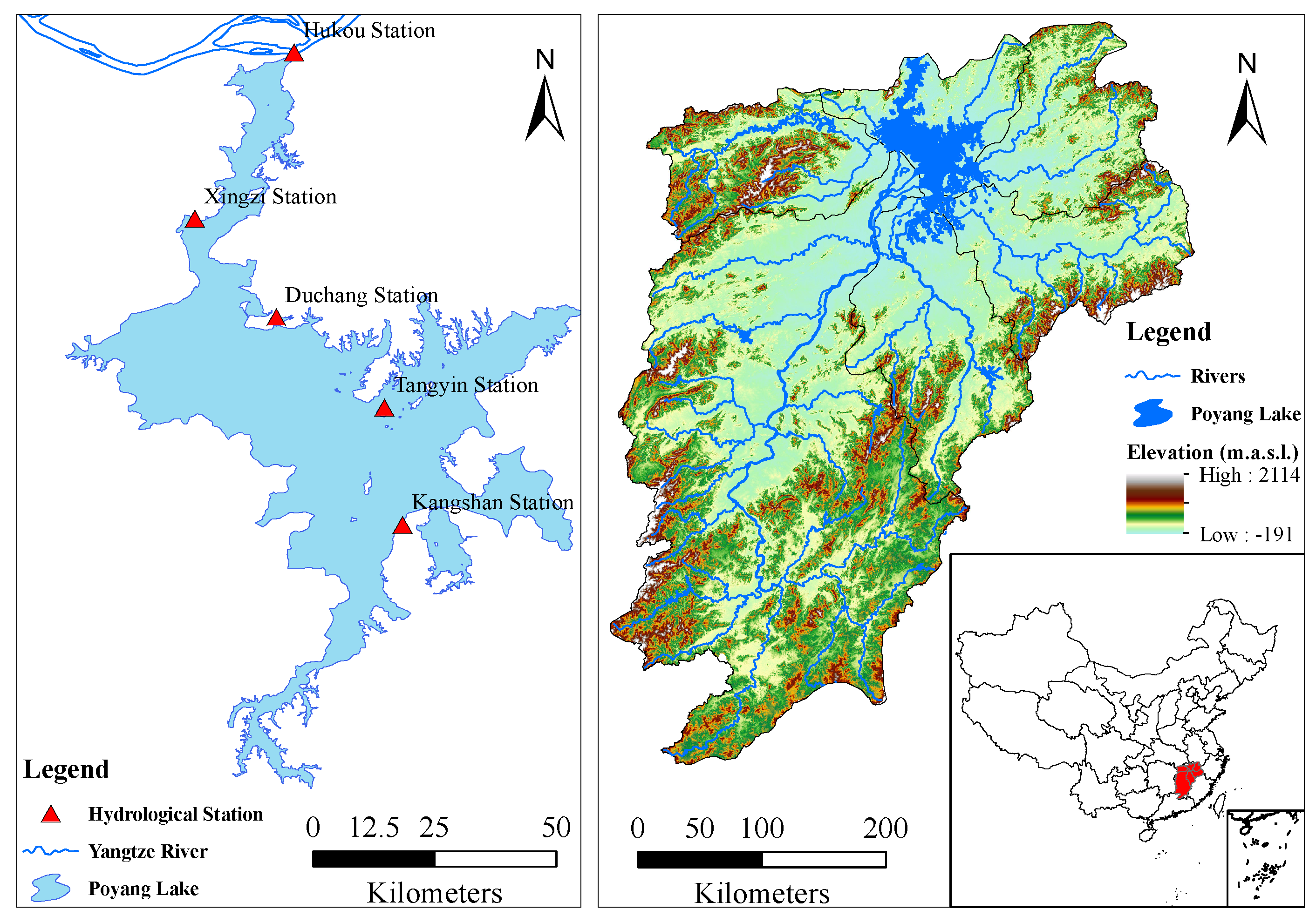
Figure 2.
Inter-annual water levels of the five monitoring hydrological stations in Poyang Lake.
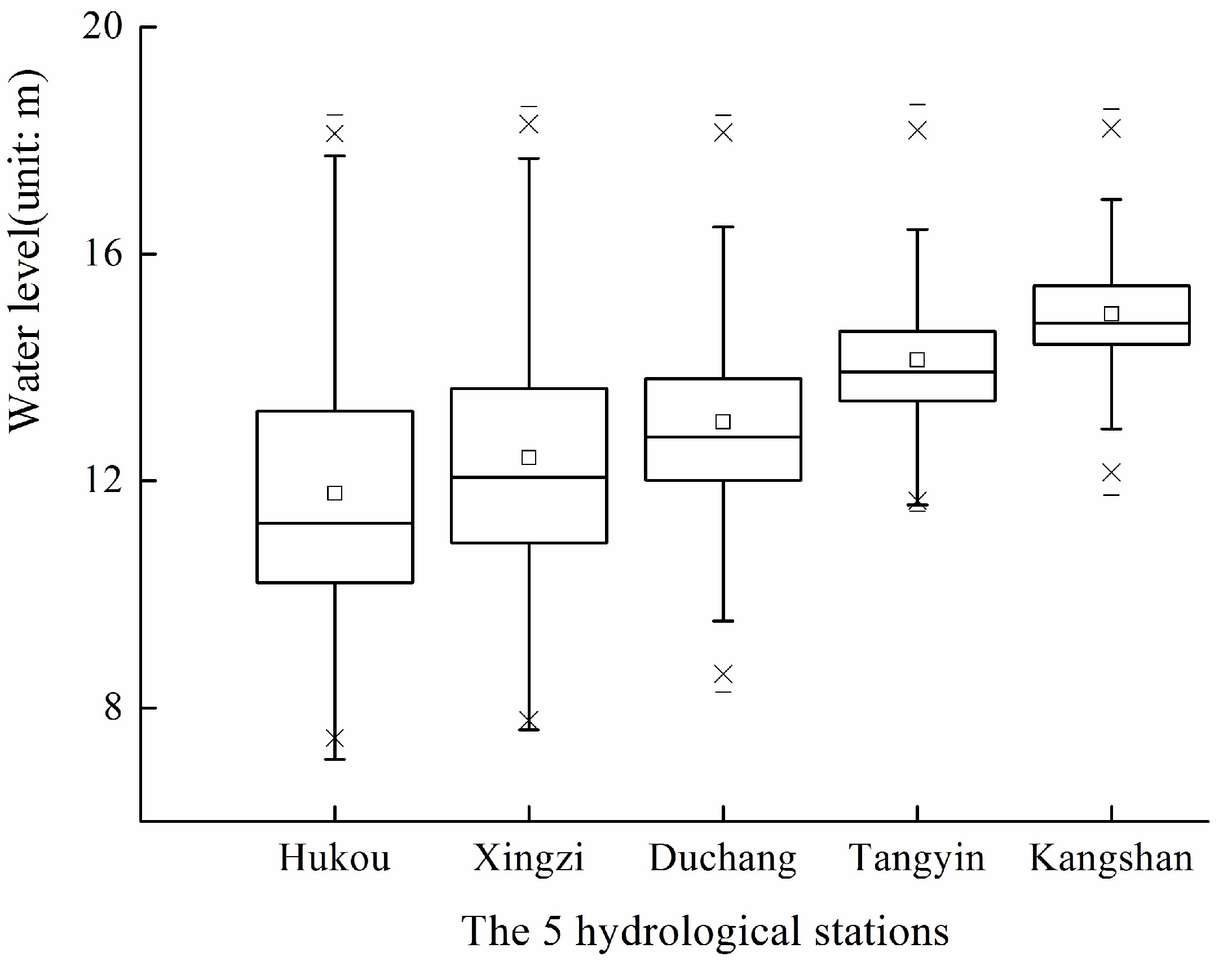
Figure 3.
Hydrographs showing recorded water levels in Poyang Lake (Wusong datumn level).
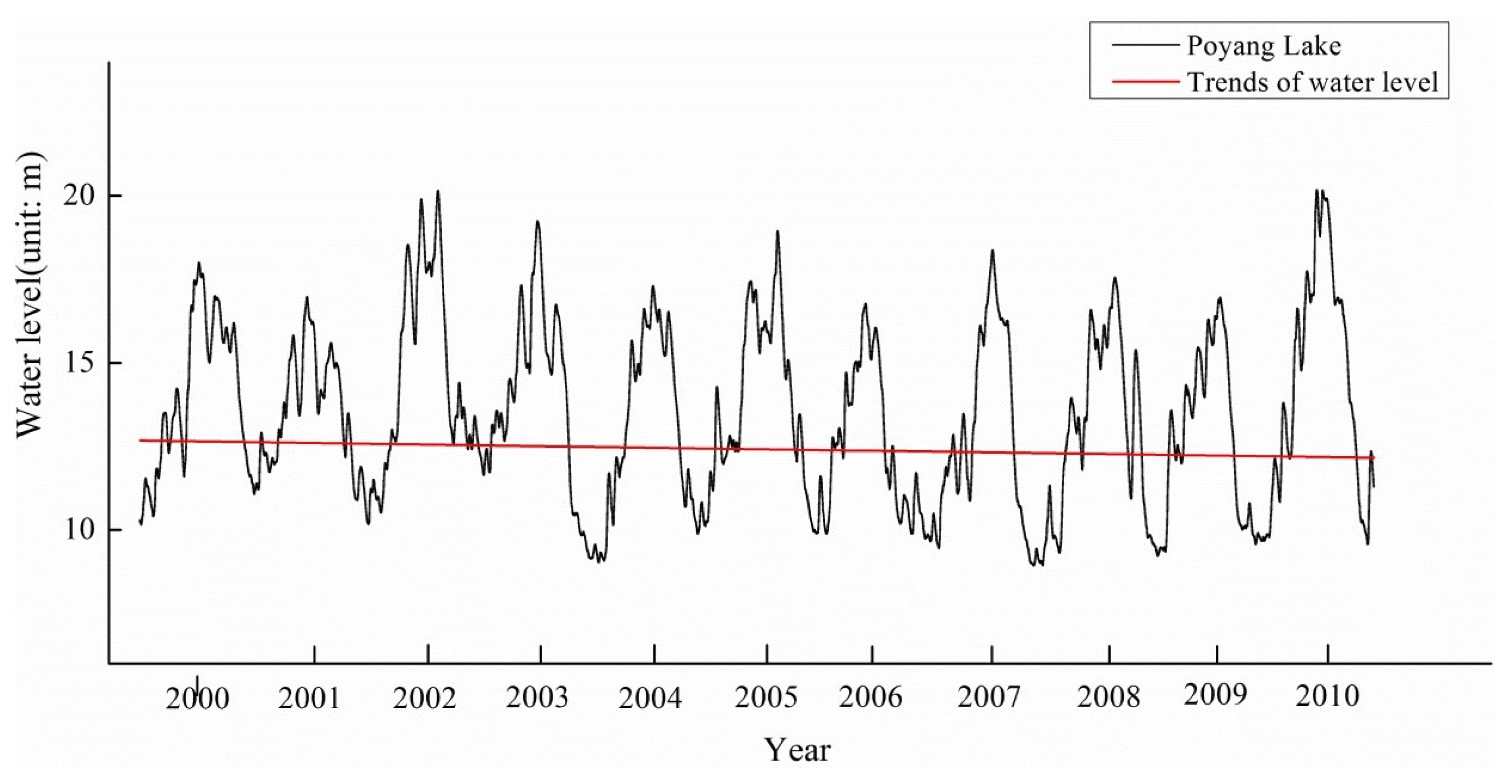
Figure 4.
The classifications of Poyang Lake wetland in springs during 2000–2010.
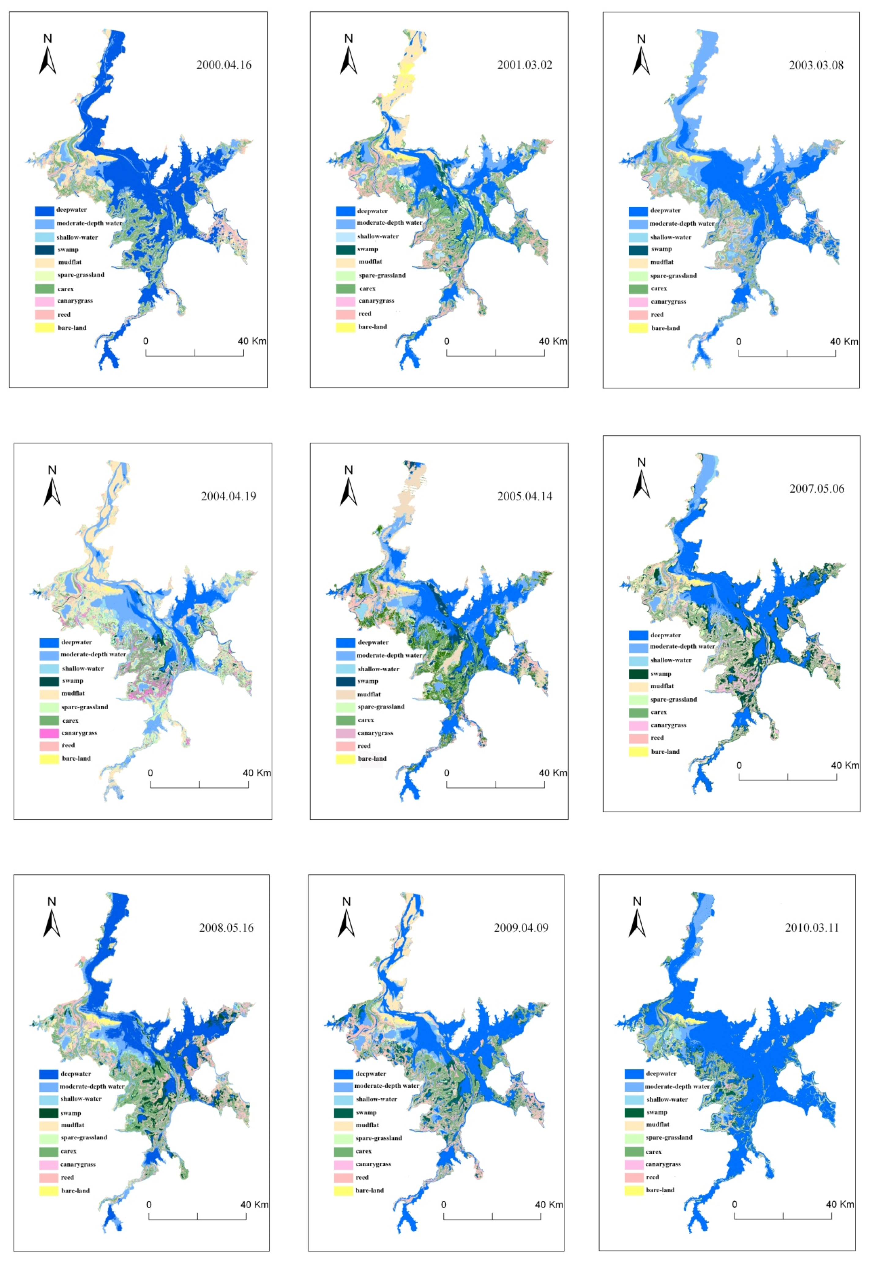
Figure 5.
The classifications of Poyang Lake wetland in spring during 2000–2010.
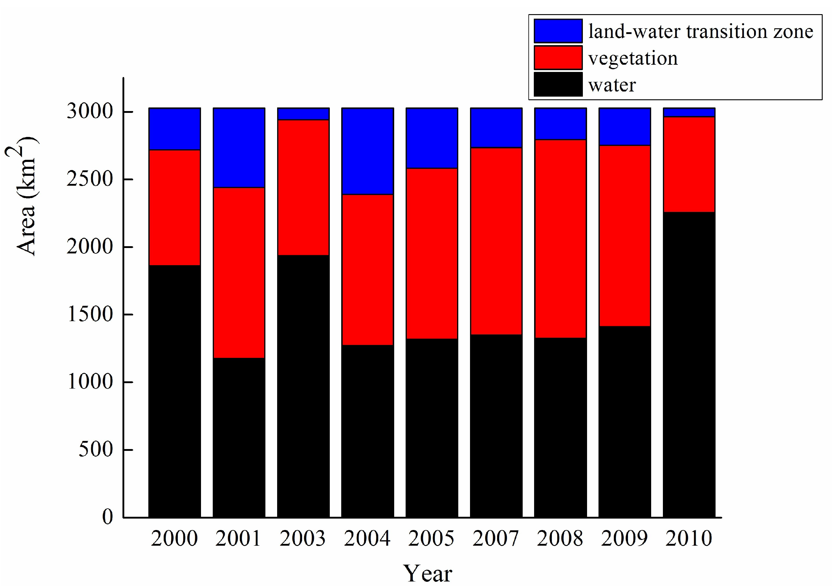
Figure 6.
The statistical total area of vegetation coverage in Poyang Lake during 2000–2010.

Figure 7.
The statistical total area of vegetation coverage in Poyang Lake during 2000–2010.

Figure 8.
Linear fits between the three types of the landscape and water level fluctuations in Poyang Lake.
Figure 8.
Linear fits between the three types of the landscape and water level fluctuations in Poyang Lake.


Table 1.
Basic information on the remote sensing images of Poyang Lake, China.
| Sensor | Date | Cloud Coverage (%) |
|---|---|---|
| ETM+ | 16 April 2000 | Cloud Coverage < 15%, and meanwhile, it can be ensured that over the study area were all cloudless. |
| ETM+ | 2 March 2001 | |
| ETM+ | 8 March 2003 | |
| TM | 19 April 2004 | |
| TM | 14 April 2005 | |
| ETM+SLC-off | 6 May 2007 | |
| TM | 16 May 2008 | |
| ETM+SLC-off | 9 April 2009 | |
| ETM+SLC-off | 11 March 2010 |
Table 2.
The habitat of the 10 spring landscapes and their significances in Poyang Lake.
| Wetland Type | Wetland Subtype | Description of Structural and Functional Characterization |
|---|---|---|
| Water | deepwater | The water depth is more than 50 cm. It is mainly distributed in the rivers, human-controlled lake areas and some parts of the large lakes in the north of Songmen Mountain in Poyang Lake. The flow velocity of the rivers is fast, making the river bed suffer from strong washing action, further resulting in the aquatic community being difficult to grow. The whole aquatic community is underdeveloped due to the insufficient conditions of light and oxygen. |
| moderate-depth water | The water depth was between 20 and 50 cm. It is mainly distributed in the middle of small seasonal lakes in delta wetland and the large lakes in the south of Songmen Mountain in Poyang Lake. The light and oxygen are relatively adequate in the area, being extremely rich in aquatic plants (mainly submerged plants), plankton, and benthos and fish resources. The regions are suitable habitats for large wading birds and swimming birds. | |
| shallow-water | The water depth was less than 20 cm, which is the transition zone for the moderate-depth water to the land. This region is gently inclined, with many types of floating-leaved macrophytes, where the aquatic community is similar to the moderate-depth water area. The foraging of the small wading birds and shore birds are often seen. | |
| Land-water transition zone | mudflat | The water level is further reduced due to natural evaporation and artificial discharging lake, and the lake bed is exposed. Abundant submerged plants and debris from filamentous algae are covering the land surface. The region is not a suitable habitat for water birds, but wild geese have a rest here once a while. |
| bare-land | The bare-land is formed by sediment deposition, basically with no vegetation coverage. It is mainly distributed in the northern lake area and the river nearby in the north of Songmen Mountain in Poyang Lake. The region always has fast flow velocity. It can often be seen covered with the thickness of 2–3 cm surface sediment in the dry season. The surface sediment is washed away by hydraulic action in the wet season. | |
| Vegetation (exposed meadow) | marsh | The marsh is close to the boundary between land and water with saturated soil, where it is mainly covered by the residual debris of aquatic plants. The soil layer consisted of incubation meadow soil, which generally alternated between wet and dry conditions more than three or four times during the year. The marsh is a good foraging site for many species of waterfowls. |
| canarygrass | The canarygrass is a perennial herb and is fond of damp environment . It is close to the mudflat, showing a zonal distribution. It has well-developed roots distributed in soil layers of 3–30 cm. It has strong resistance of drought and waterlogging, which can be used to keep soil and water better. The canarygrass grows best in tidal slag sandy soil with high organic matter content in the low-lying swamp meadows and flooded meadows. It is also suitable to grow in the fertile loam and clay. | |
| sparse-grassland | The soil layer consisted of meadow soil, and the soil was saturated. The marsh plants grew on sparse grassland, which was located at a low elevation. The germination time of the vegetation was short, and the vegetation grew sparsely. The fresh buds of the vegetation were eaten by waterfowl. | |
| carex (dense grassland) | The carex is the dominant species most widely distributed in the Poyang Lake wetland. It germinates and grows rapidly in the beach wetland with high elevation and long-term exposure. The carex has large coverage and good concealment, where feathers and resting marks of the waterfowls during the evening can be seen. | |
| reed | The reed is a representative of highland-emergent aquatic plants in the wet season, and withers in winter. The sub-lakes and rivers are separated from Poyang Lake, in the winter. At that time, the withered reed is distributed around the lakes, then forming a better concealment. |
Table 3.
Correlation analysis between the spring landscapes and the water levels. * and ** represent and , respectively (a 2-tailed test of significance was used).
Table 3.
Correlation analysis between the spring landscapes and the water levels. * and ** represent and , respectively (a 2-tailed test of significance was used).
| Variables | Water Level | Deep-Water | Moderate-Depth Water | Shallow-Water | Mudflat | Bare-Land | Marsh | Canary-Grass | Sparse-Grassland | Carex | Reed |
|---|---|---|---|---|---|---|---|---|---|---|---|
| water level | 1 | 0.667 * | −0.033 | −0.366 | −0.861 ** | −0.385 | 0.11 | 0.066 | −0.256 | −0.245 | −0.718 * |
| deepwater | 1 | −0.51 | −0.718 * | −0.708 * | −0.235 | −0.144 | −0.375 | −0.438 | −0.207 | −0.387 | |
| moderate-depth water | 1 | 0.561 | 0.116 | −0.126 | −0.478 | 0.212 | 0.597 | −0.185 | −0.257 | ||
| shallow-water | 1 | 0.39 | −0.086 | −0.022 | 0.116 | 0.562 | −0.004 | 0.05 | |||
| mudflat | 1 | 0.233 | −0.097 | −0.023 | 0.519 | −0.002 | 0.427 | ||||
| bare-land | 1 | 0.063 | −0.397 | −0.344 | 0.738 * | 0.505 | |||||
| marsh | 1 | 0.558 | −0.364 | 0.163 | 0.096 | ||||||
| canary-grass | 1 | 0.105 | −0.323 | −0.104 | |||||||
| sparse-grassland | 1 | −0.613 | −0.444 | ||||||||
| carex | 1 | 0.692 * | |||||||||
| reed | 1 |
© 2017 by the authors. Licensee MDPI, Basel, Switzerland. This article is an open access article distributed under the terms and conditions of the Creative Commons Attribution (CC BY) license (http://creativecommons.org/licenses/by/4.0/).
Share and Cite
MDPI and ACS Style
You, H.; Fan, H.; Xu, L.; Wu, Y.; Wang, X.; Liu, L.; Yao, Z.; Yan, B. Effects of Water Regime on Spring Wetland Landscape Evolution in Poyang Lake between 2000 and 2010. Water 2017, 9, 467. https://doi.org/10.3390/w9070467
AMA Style
You H, Fan H, Xu L, Wu Y, Wang X, Liu L, Yao Z, Yan B. Effects of Water Regime on Spring Wetland Landscape Evolution in Poyang Lake between 2000 and 2010. Water. 2017; 9(7):467. https://doi.org/10.3390/w9070467
Chicago/Turabian StyleYou, Hailin, Hongxiang Fan, Ligang Xu, Yongming Wu, Xiaolong Wang, Lizhen Liu, Zhong Yao, and Bangyou Yan. 2017. "Effects of Water Regime on Spring Wetland Landscape Evolution in Poyang Lake between 2000 and 2010" Water 9, no. 7: 467. https://doi.org/10.3390/w9070467
Note that from the first issue of 2016, this journal uses article numbers instead of page numbers. See further details here.