Article

Designing an Index to Reveal the Potential of Multipurpose Landscapes in Southern Africa

by
Emmanuel Torquebiau
1,*,
Nathalie Cholet
2,
Willem Ferguson
3 and
Philippe Letourmy
1
1
Centre de Coopération Internationale en Recherche Agronomique pour le Développement (CIRAD), UR 102, 34398 Montpellier, France
2
Montpellier SUPAGRO, Avenue Agropolis, 34093 Montpellier, France
3
Centre for Environmental Studies, University of Pretoria, Pretoria 0002, South Africa
*
Author to whom correspondence should be addressed.
Land 2013, 2(4), 705-725; https://doi.org/10.3390/land2040705
Submission received: 12 September 2013 / Revised: 6 November 2013 / Accepted: 18 November 2013 / Published: 2 December 2013
(This article belongs to the Special Issue Landscape Perspectives on Environmental Conservation)

Abstract

:
Multipurpose mosaic (“ecoagriculture”) landscapes can serve the purpose of land sharing to combine objectives of agricultural production and biodiversity conservation. Rewarding the people who shape and maintain those landscapes could act as a mechanism to generate added-value representing an indirect payment for ecosystem services. We investigated the feasibility of such an approach in two areas in Southern Africa differing in spatial configurations, history and socio-economic context. We designed and tested a composite index describing the state of each landscape in terms of ecoagriculture criteria (conservation, production, institutions and livelihood) and ecosystem services (provisioning, regulating and cultural services). The resulting index is made up of different sets of data each comprising 40 scores, obtained from stakeholders’ participatory interviews. Ecosystem services are in general assigned more importance than ecoagriculture criteria. In both cases, cultural services receive the highest scores, whereas the lowest ones are attributed to the livelihood and institutions in the Zimbabwean and South African sites, respectively. Index values reveal that the South African site, where there is more integration between land-use units, does better in terms of a landscape performing multiple functions. Provided relevant stakeholders are involved and a certification mechanism is developed, the landscape labelling index can be used to recognize and reward the value of outstanding rural landscapes.

1. Introduction

Agricultural production and biodiversity conservation have long been considered antagonistic. Protected areas have conventionally been designed to set aside land for conservation with restricted access, while land conversion to agriculture was thought to lead to natural habitat loss or degradation. Now reaching the world’s finite land boundaries, agriculture and conservation can no longer compete and instead must be reconciled in order to identify trade-offs between them [1,2,3]. Recent recognition of their mutual interdependence—the potential of agricultural areas for conservation as well as the role of biodiversity for agricultural production [4]—highlights the possibility that these two contrasted land-uses can benefit from each other. The land sharing vs. land sparing debate [5] has generated useful knowledge on the pros and cons of conservation in heterogeneous landscapes and is seen as a useful framework for making land-use decisions addressing the trade-offs between food production and biodiversity conservation [1].
Multipurpose landscapes can be defined as areas that can simultaneously produce several commodities, e.g., food and wood, or can have several uses, e.g., agricultural production and nature conservation. The multipurpose nature of such areas also refers to the fact that they can also provide a range of other services which are normally not included in market mechanisms, e.g., ecosystem services such as carbon capture, pollination, or offsetting environmental externalities, e.g., pollution. A multipurpose landscape is also relevant to deal with public policy and collective action initiatives (e.g., farming practices, construction of infrastructures) and to address the management of public goods such as water or biodiversity [6]. In recent literature about innovative land management options, landscapes are seen as an operational scale for understanding and shaping the relationship between society and the environment [7] and landscape approaches are recommended to reconcile conservation and development trade-offs [8,9]. The integration between conservation and development is easier at scales larger than a plot, a farm or even a protected area, making landscape-based approaches useful to identify synergies and trade-offs between competing land-uses and allowing to link local initiatives with larger-scale national and regional processes [10].
Ecoagriculture—“a fully integrated, landscape-level approach to agriculture, conservation and rural livelihoods” [3]—has been proposed as an answer to the challenge of combining land uses at landscape level. Building from similar earlier concepts, including sustainable agriculture, agroecology and integrated resource management, ecoagriculture focuses on the synergy existing between conservation, production and livelihoods as the three main components of integrated multipurpose landscapes, working at a large scale, both spatial and temporal [11]. Ecoagriculture landscapes are land use mosaics with natural areas and agricultural production areas, as well as other landscape features (such as inhabited land), both configured and managed to have a neutral or positive impact on each other, and integrating institutional mechanisms as a fourth component required for coordination at the landscape level [12]. When such positive interactions occur between the multiple units of a landscape mosaic, these heterogeneous landscapes become more than the sum of their parts.
In ecoagriculture, special importance is given to biodiversity conservation, which must be integrated into the agricultural and rural development per se, but must also be recognized as productive, for example when it supports natural or semi-natural habitats for useful species such as pollinators. In fact, besides the protection of wild biodiversity often considered as an ethical imperative, conservation within an ecoagriculture landscape supports ecosystem services [3], i.e., the multiple benefits humans obtain from ecosystems [4]. They range from provision of food and fresh water, carbon sequestration and pollination, to aesthetics and spirituality. Although essential for human well-being, their decline in both natural and human-modified ecosystems was noted by the Millennium Ecosystem Assessment [4], insisting on the urgent need to protect or restore ecosystem services. Virtually all types of landscapes, from human-dominated agricultural landscapes to wilderness areas, can provide ecosystem services. Strategic goal D of the Aichi Biodiversity Targets highlights the need to “enhance the benefits to all from biodiversity and ecosystem services”. Target 14 specifically insists on safeguarding ecosystems that provide essential services [13].
A much-debated approach to translate the non-market value of ecosystem services into financial incentives is the so-called “Payments for Ecosystem Services” (PES) schemes which compensate landowners or managers for management strategies that provide ecosystem benefits to other parties [14,15]. PES are defined as (a) a voluntary transaction where (b) a well-defined ecosystem service or a land use likely to secure that service (c) is bought by an ecosystem service buyer (d) from an ecosystem service provider (e) only if the service provision is secured (conditionality) [16,17]. A simpler definition goes as follows: A PES pays an economic operator for a service provided to other operators by means of a deliberate action aimed at preserving, restoring or increasing an agreed environmental service [18]. By including environmental objectives in land use decisions, PES make a connection between the maintenance and restoration of ecosystem functions and improvements in living conditions, or even poverty alleviation. Watershed protection, atmospheric carbon fixation by plants and biodiversity conservation are classic examples of PES.
One of the problems of the PES approach is the difficulty of defining and monitoring ecosystem services—necessary to ensure conditionality—or simply of finding a willing buyer. Other limiting factors of PES schemes include the evaluation of opportunity costs, used as a questionable proxy for ecosystem services values, as well as the high transaction costs often involved in the payments thus limiting their implementation on the ground. Moreover, although designed to secure environmental protection and to alleviate poverty, PES face the challenge of distributing benefits widely and avoiding societal conflicts over land-use [15,19]. In view of these limitations, and given the recognized importance of the landscape scale, Ghazoul et al. [14] proposed a new approach called “landscape labelling”, which combines environmental certification principles with PES ideas.
Certification is the process of indicating through labelling that a commodity complies with a set of regulations governing a production process [14]. It can be used to reach various goals. Some well-known examples focus on achieving social or environmental efficiency, such as fair trade and eco-labels, through the determination of minimum performance requirements—fair trade coffee and Forest Stewardship Council certifications for instance [20]. Geographical Origin labels are also a form of certification. The landscape labelling approach is based on the recognition and reward of ecosystem services provided by a landscape through certification principles. The certification goal of a landscape label is therefore the sustainable delivery of a wide variety of ecosystem services, which can also constitute criteria for its granting process [14]. In the landscape labelling approach, certification is not applied to a specific product but rather at the whole landscape level, thus potentially generating added-value not only to a specific commodity, but potentially to all commodities or services (e.g., ecotourism, lodging) originating in the landscape in question.
As any other market tool, a landscape label can create or give access to niche markets, increase product recognition and/or secure price premiums. In this overall approach, opportunity is also provided for minor products to attain market benefits by association with commercially important ones. A landscape label based on ecosystem services delivery offers other benefits going beyond PES schemes’ issues, including reduced transaction costs and improved inclusivity (see [14] for a detailed list and explanations). The question of who is paying for ecosystem services, namely the willing buyer in PES schemes, also becomes irrelevant under landscape certification principles for the provision of ecosystem services is indirectly rewarded through the added value paid by consumers.
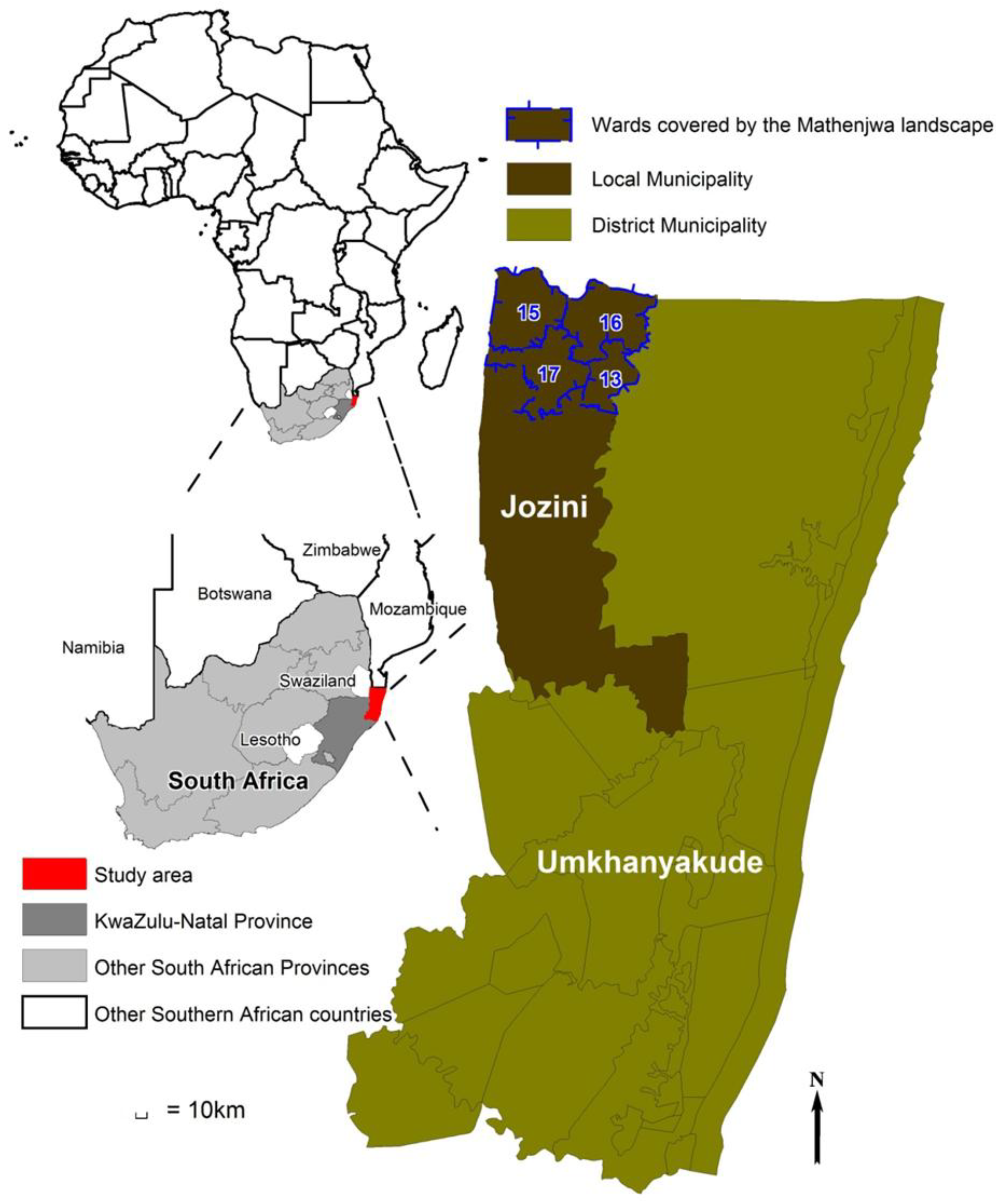
Guided by the principles presented by Ghazoul et al. [14], we investigated the feasibility of combining PES and landscape labelling through the design of a “landscape label” and its testing in two contrasting multipurpose landscapes in Southern Africa: a former South African homeland showing characteristics of an ecoagriculture mosaic on the one hand, and a Zimbabwean conservancy where small scale farming is found in proximity to formal wildlife conservation areas on the other hand. Specifically, we designed a composite index describing landscape conditions in terms of production, conservation, institutions, well-being and ecosystem services and we compared index values obtained from answers to a questionnaire implemented with a variety of stakeholders. The main hypotheses behind our work were (1) that landscape structure, ecosystem services and consequently the value of the labelling index, are influenced by farmers’ and other stakeholders’ points of view; and (2) that there should be a positive correlation between landscape heterogeneity and index value. Our two studies areas are each located in a “TransFrontier Conservation Area (TFCA)”, i.e., areas straddling across the boundaries of two or more countries and designed to associate objectives of nature conservation as well as multiple resource use areas [21]. As such, TFCAs incorporate both human dwellings (typically farms and villages) as well as natural and/or protected areas.

2. Materials and Methods

2.1. Study Areas

2.1.1. South African Site (KZN)

The South African site is located within the Lubombo TFCA, at the border between South Africa, Mozambique and Swaziland. Our site is an area of approximately 547 km2 located at the extreme North of the KwaZulu-Natal (KZN) Province, South Africa (approx. lat 26°48′S to 27°00′S; long 32°00′E to 32°15′E; Figure 1), from which a major part is known as the Mathenjwa Tribal Area. Annual rainfall ranges from 500 mm in the Eastern lowlands (100 m asl) to 800 mm in the Western highlands (600 m asl). There is a markedly dry spell from June to August while the wettest months comprise the warm period from November to March. Dramatic year-to-year rainfall variation is common. Mean annual temperature varies from 22 °C (lowlands) to 20 °C (highlands), with mean maxima and minima around 30 and 10 °C, respectively. Most soils are shallow lithosols on an acidic rhyolite bedrock that is little weathered and frequently apparent, giving rise to shallow, stony soils.
Figure 1. Location of the KwaZulu-Natal (KZN) site (Mathenjwa landscape) within South Africa’s administrative boundaries.
Land 02 00705 g001
The KZN site is part of the Maputaland-Pondoland-Albany biodiversity hotspot. It harbours many endemic plants and comprises of one of the most endangered vegetation types in South Africa [22]. Farms are scattered in the landscape, with fields located both nearby houses and further away. Virtually all people grow maize although average yields are rather low (1.5–2 t·ha−1) and crop failure (e.g., because of poor rains) is not uncommon. Other crops (pumpkins, peanuts, watermelon, beans, different vegetables) are irregularly distributed. Livestock is present, mostly grazed in distant lands or freely roaming. Population density is about 67 people·km−2, with about 10% of households having more than 10 members. Gender proportions show an average 82 men for 100 women (across all ages). About 10% of the adult population is considered employed, 15% unemployed and 75% not economically active, while 48% of households have an annual income of less than US$660, indicating household food insecurity.
The Mathenjwa people, who had been raising cattle extensively since their arrival in the area around the 17th century, were progressively forced to abandon subsistence nomadic pastoralism and shifting cultivation at the profit of sedentary peasant farming [23]. This change in farming practices was followed by an evolution of the landscape in the last 70 years towards an increase of wooded areas on long fallows and abandoned grazing areas. Still practicing subsistence agriculture nowadays, the Mathenjwa shaped their landscape as a mosaic of fields and natural or semi-natural areas. The resulting landscape is a beautiful blend of farmed and wild zones on a hilly terrain showing obvious potential for a long-term, balanced environmental management.

2.1.2. Zimbabwean Site (SVC)

The Zimbabwean site is found within the South-East Lowveld region of Zimbabwe in the Great Limpopo TFCA, between Zimbabwe, South Africa and Mozambique. The Savé Valley Conservancy (SVC) landscape covers approximately 6,266 km2 (approx. lat 19°50′S–21°00′S; long 31°30′E–32°30′E; Figure 2). It is made up of a central private protected area, the Savé Valley Conservancy itself, plus the neighbouring 19 wards, mainly farming areas managed as communal lands or under resettlement schemes. The central SVC is a gently undulating plain with scattered hills at an altitude from 600 to 400 m asl. There is a marked variation in the occurrence of different soil types according to the underlying sedimentary of metamorphic geology, locally referred to as black, red, clay, loam, alluvial, sandy, saline and rocky soils. The climate is semi-arid, characterized by a single hot and wet season from November to March and a long warm then cold dry season from April to October. The mean annual rainfall, around 500 mm, varies both within the region and between years. The area is prone to drought episodes. Daily temperatures vary from 10 °C to 25 °C in June and July, and from 18 °C to 32 °C between October and January, the annual mean temperature being around 23 °C.
The natural vegetation is the typical Miombo, a densely wooded savanna where trees are extensively used for various purposes by local people. The SVC, only formal protected area within the Savé Valley landscape, representing just over half of its total area (3,442 km2), supports a wide diversity of animal species—mammals, reptiles, amphibians, fish and some rare birds. Outside its boundaries, small-scale farming dominates the landscape. Main food crops include sorghum and maize while cotton is ploughed as a cash crop, and cattle and goats are raised for savings and food. Socio-economic conditions greatly vary among the different wards. The overall analysis provides average population densities varying from 12 people·km−2 in resettlement schemes to 63 people·km2 within communal lands. The areas adjacent to the SVC are characterized by high levels of poverty and environmental degradation.
The south-east of Zimbabwe is the home of the national wildlife industry. Private wildlife ranching started during the 1960s, in parallel with cattle ranching, and progressively took over, resulting in a dense network of private conservancies spread throughout the region. The SVC, considered to be the largest private-owned wildlife reserve in the world, comprises multiple properties held by private ranchers, local council, government and one community [24]. Each unit (called ranch) intends diversification, but wildlife tourism—mainly trophy hunting and, before the recent political upheavals in Zimbabwe, ecotourism—remains the main activity throughout the conservancy. Human-wildlife conflicts, known to occur in the Savé Valley landscape, prevent big emblematic species such as elephants or lions to roam freely outside the boundaries of the SVC, but similar habitats in areas located outside the SVC allow to envisage a similar biodiversity, somewhat reduced by human activities, with a potential for conservation.
Figure 2. Location of the SVC site (Savé Valley Conservancy) within Zimbabwe’s administrative boundaries
Land 02 00705 g002

2.2. Methods

The Landscape Index (LI)—consists of a set of 40 questions out of which 20 are relevant to ecoagriculture criteria and 20 to ecosystem services criteria. The index was specifically designed for the purpose of the present study. It builds on an existing landscape performance assessment framework [11] that provides the basis for an Ecoagriculture Landscape Performance (ELP) sub-index, further complemented by an Ecosystem Services (ES) sub-index. The ELP sub-index has been designed by the Ecoagriculture Partners Group (see [11]). It is based on the same goals that define the ecoagriculture concept: conservation, institutions, livelihood and production [12], defining four categories in the analysis. Each goal is further divided into five sub-goals, thus providing a set of 20 criteria (=20 questions) that are presumed to be desirable in any ecoagriculture landscape (Table 1). The ES sub-index, specifically created to further take into account the supply of ecosystem services, provides a set of 20 ecosystem services objectives (=20 questions; Table 2). We used the typology for ecosystem services proposed by de Groot et al. [25], slightly simplified, and organized different services as a function of the categories provided by the Millenium Ecosystem Assessment [4], i.e., provisioning, regulating and cultural services. We deliberately excluded supporting services (nutrient cycling, primary production, etc.) as these are more difficult to assess for non-specialists. Combined together, these two sub-indexes represent a range of criteria covering current thinking on the “landscape approach” [9], landscape sustainability [8] and multi-objective management of rural landscapes [26].
Table 1. Detailed framework of the Ecoagriculture Landscape Performance (ELP) sub-index: ecoagriculture goals and criteria [11].
CONSERVATION—The landscape conserves, maintains and restores wild biodiversity and ecosystem services
1.
Does the landscape contain an adequate quantity and suitable configuration of natural and semi-natural habitat to protect native biodiversity?
2.
Do natural and semi-natural habitats in the landscape approximate the composition and structure of the habitats historically found in the landscape?
3.
Are important species within the landscape biologically viable?
4.
Does the landscape provide locally, regionally and globally important ecosystem services?
5.
Are natural areas and aquatic resources adequately buffered from productive areas and activities?
PRODUCTION—The landscape provides for the sustainable production of crops, livestock, fish, forests, etc.
6.
Do production systems satisfy demand for food and agricultural products by consumers inside and outside the landscape?
7.
Are production systems financially viable and can they adapt to change in input and output market?
8.
Are production systems resilient to disturbances, both natural and human?
9.
Do production systems have a neutral or positive impact on wild biodiversity and ecosystem services in the landscape?
10.
Are species and varietal diversity of crops, livestock, fisheries and forests adequate and maintained?
LIVELIHOOD—The landscape sustains or enhances the livelihoods and well-being of all social resident groups
11.
Are households and communities able to meet their basic needs while sustaining natural resources?
12.
Is the value of households and community assets increasing?
13.
Do households and communities have sustainable and equitable access to critical natural resources stocks and flows?
14.
Are local economies resilient to change in human and non-human population dynamics?
15.
Are household and communities resilient to external shocks such as flooding, drought, changes in commodity prices, disease epidemics and others?
INSTITUTIONS—The landscape hosts institutions that support the actions needed to integrate the three previous goals
16.
Are mechanisms in place and functioning for cross-sectoral interactions at landscape scale?
17.
Do producers and other community members have adequate capacity to learn and innovate about practices that will lead to integrated landscapes?
18.
Does public policy support integrated landscapes?
19.
Are market incentives conducive to integrated landscapes?
20.
Do knowledge, norms and values support integrated landscapes?
Table 2. Detailed framework of the Ecosystem Services (ES) sub-index: categories and sub-categories (adapted from [4,25]).
PROVISIONING SERVICES—Services human can use/consume (tangible benefits)
21.
Food—Fish, game, fruits, roots, etc.
22.
Fresh water—Provision of water for consumptive use (e.g., drinking, irrigation and industrial use)
23.
Energy sources—Firewood, organic matter, etc.
24.
Raw materials—Building wood, sand, clay soil, fiber, etc.
25.
Genetic resources—Genes or information contained in wild animal and plant species as a source of improved crops varieties and domesticated animal species (e.g., improved crop resistance to pathogens and pests)
26.
Medicinal resources—Drugs and pharmaceuticals, chemical models and tools, etc.
27.
Ornamental resources—Resources for fashion, handicraft, jewelry, pets, decoration (e.g., fur, skins, feathers, ivory, orchids, shells, flowers)
REGULATING SERVICES—Services humans need to survive (intangible benefits)
28.
Air quality regulation—UVb protection by 03, maintenance of (good) air quality, etc.
29.
Climate regulation—Maintenance of a favorable climate (temperature, precipitation, etc.) for human habitation, health, cultivation, etc.
30.
Disturbance prevention—Storm protection, flood prevention, etc.
31.
Water regulation—Role of land cover in regulating runoff and river discharge (e.g., drainage and natural irrigation, medium for transport)
32.
Soil formation/retention—Maintenance of natural productive soils (weathering of rocks, accumulation of organic matter), prevention of erosion, etc.
33.
Water purification/Waste treatment—Filtering of water, pollution control, detoxification, filtering of dust particles, etc.
34.
Disease/Pest regulation—Biological control (population control through trophic-dynamic relations)
35.
Pollination—Presence of and habitat for wild-pollinator species
CULTURAL SERVICES—Services humans need to “feed their minds”
36.
Aesthetic values—Enjoyment of scenery, beauty of the landscape, etc.
37.
Recreational values—Ecotourism, adventure tourism (such as hiking, biking, rock-climbing), safari hunting, etc.
38.
Educational values—Scholl excursions, scientific research, etc.
39.
Spiritual and historic values—Use of nature for religious or historic purposes (communicating with ancestors, etc.)
40.
Cultural and artistic values—Inspiration, nature as motive in books, poems, films, advertising, etc.
The ELP and ES sub-indexes are thus integrated within a list of 40 questions answered and scored using a consistent methodology, to allow for comparison. Each question can be answered by stating “How well the landscape is performing regarding the specific criteria considered?” or “Does the landscape supply this ecosystem service?” The interviewee gives an answer between 1 and 5 where 1 indicates a poor performance/supply and 5 a high performance/supply. The scoring process involved two groups of stakeholders, i.e., local farmers and a group of other experts (different key informants such as development officers, conservation scientists, local leaders, officers from governmental services, etc.). Groups of 5–10 local farmers (South Africa, n = 9 groups; Zimbabwe, n = 15 groups) and technical experts (South Africa, n = 7; Zimbabwe, n = 4) were gathered through similar methods but separately: community participatory workshops were implemented within each selected landscape, while local experts were asked to participate in a specific meeting or contacted individually. This separation intended to make local participants more audible, while allowing for comparison between local participants’ perceptions and key informants’ knowledge. These 16 (South Africa) and 19 (Zimbabwe) interviews yielded 640 and 761 individual data points for the KZN and SVC sites, respectively.
Community meetings and interviews were organized with the assistance of a local person also acting as an interpreter from/to English. Time was taken to interact with farmers (including farm visits and landscape walks) and build confidence before engaging into interviews. Questions were carefully explained whenever necessary. People were given time to think, discuss, hesitate or change their mind before giving the final answering. In the case of group meetings, people were gathered following a few days advance notice and on the basis of willingness to participate. Participants were given the possibility to check and compare their answers and discuss their choices. The objective of applying this set of participatory research approaches (see, e.g., [26]) was to make sure to obtain as reliable information as possible. We faced terminology and language difficulties. For instance, words such as “landscape”, “ecosystem” or “resilient” cannot be translated into local languages. We had to rely on circumlocutions to explain what we meant. The role of interpreters (young English-speaking students) from the community itself was here crucial. We carefully trained them in advance with clear instructions about the use of scientific jargon and the risk of biasing answers by a wrongly spelled out or leading question. Together with the significant time spent with interviewees, we believe that this set of participatory research rules secured data of reasonable quality.
Once implemented in the field, the LI provides different sets of data, each comprising 40 scores ranging from 1 to 5. Scores were transformed to fit in a standardized scale from 0 to 1 and analysed using the software SAS. Since our objective was a preliminary assessment of the feasibility of landscape labelling through the comparison of two contrasted sites—and not a thorough analysis of index values—we applied the following simple model Equation (1) of analysis of variance to all data:
Yijk = µ + αi + βj + (αβ)ij + γjk + εijk
where:
  • Yijk is the score for question k of category j by stakeholder i,
  • µ is the grand mean,
  • αi is the stakeholder i effect,
  • βj is the category j effect,
  • (αβ)ij is the interaction (stakeholder i, category j) effect,
  • γjk is question k of category j effect and
  • εijk is the residual error.
In all tests, the level of significance was kept at 5%. We report p-values in tables only when they show significant differences (p-value < 0.05). Mean scores for each of the 40 questions, by site and by stakeholder, are given in Table A1. However, these should be used with caution because of the small sample size. Results by category, as they appear in Table 3, Table 4, Table 5 and Table 6, combine scores from different questions under the same criteria and hence carry more significance.

3. Results

At site level (KZN vs. SVC), the analysis of ELP and ES variance as a function of site, of stakeholder, or of the interaction between site and stakeholder, did not reveal any significant difference (Table 3). Based on those means, the overall landscape index (LI) did not show any significant difference across sites either.
Table 3. Means of ELP and ES sub-indices values across sites as a function of stakeholders. ES, Ecosystem Services; ELP, Ecoagriculture Landscape Performance; KZN, KwaZulu-Natal; SVC, Savé Valley Conservancy.
FarmersOther Experts
KZNELP0.65630.5277
ES0.70970.6821
Overall landscape index LI0.6439
SVCELP0.58750.5313
ES0.69960.5687
Overall landscape index LI0.5967
When taking into account categories within the ELP and ES sub-indices, some statistically significant differences appeared. In South Africa (KZN site; Table 4), categories within the ELP sub-index showed a difference between stakeholders, with Farmers > Other experts (indicating that farmers give ecoagriculture (ELP) criteria a higher importance than other key stakeholders do). There were also differences among categories within the ES sub-index, with Cultural > Provisioning > Regulating (indicating a higher importance given to cultural services). The lowest score was given by the other experts group for the institution category while the highest was given by farmers for cultural services (Table 4).
In Zimbabwe (SVC site; Table 5), ELP sub-index values showed differences between categories (Farmers > Other experts and Conservation > Institutions = Production > Livelihood). ES sub-index values showed differences between stakeholders (Farmers > Other experts) and between categories (Cultural > Provisioning = Regulating). Thus, in Zimbabwe as well as in South Africa, farmers tend to give higher scores than other stakeholders and cultural ecosystem services consistently rank higher than other services at both sites. The lowest score at the SVC site is given to the livelihood category by the other experts group while the highest is given by farmers for cultural services (Table 5).
Table 4. Means of ELP and ES sub-index values at the KZN site (standard deviation in brackets). ES, Ecosystem Services; ELP, Ecoagriculture Landscape Performance; KZN, KwaZulu-Natal.
ELPp-Value (Stakeholder Effect)
FarmersOther Experts
Conservation0.6611 (±0.0411)0.6607 (±0.0466)<0.0001
Production0.6528 (±0.0411)0.4857 (±0.0466)
Livelihoods0.6972 (±0.0411)0.5143 (±0.0466)
Institutions0.6139 (±0.0411)0.4500 (±0.0466)
Means0.65620.5275
ESMeans
Provisioning0.7380 (±0.0274)0.6632 (±0.0311)0.7006
Regulating0.5868 (±0.0257)0.6250 (±0.0291)0.6059
Cultural0.8667 (±0.0325)0.8000 (±0.0368)0.8333
p-value (category effect)<0.0001
Finally, when analysing ES and ELP criteria at site level, based on individual data points, there was a difference between South Africa and Zimbabwe for ES (KZN > SVC) but not for ELP, and a significantly higher value for the overall LI index value at the KZN site (Table 6). However, when analysed by stakeholder (Farmers vs. Other experts; Table 7), ES criteria appeared to be higher in KZN only for the other experts group while it was ELP criteria which were higher, also in KZN, but for farmers. In other words, the difference between the two sites is due to a stakeholder effect.
Table 5. Means of ELP and ES sub-index values at the SVC site (standard deviation in brackets). ES, Ecosystem Services; ELP, Ecoagriculture Landscape Performance; SVC, Savé Valley Conservancy.
ELPp-Value (Interaction Effect)
Farmers Other ExpertsMeans
Conservation0.5716 (±0.0374)0.7250 (±0.0724)0.64830.0052
Production0.5533 (±0.0374)0.5625 (±0.0724)0.5579
Livelihoods0.5566 (±0.0374)0.3750 (±0.0724)0.4658
Institutions0.6683 (±0.0374)0.4625 (±0.0724)0.5654
Means0.58740.5312
ESp-Value (Category Effect)
Farmers Other ExpertsMeans
Provisioning0.6476 (±0.0300)0.5446 (±0.0581)0.59610.0023
Regulating0.6989 (±0.0280)0.5000 (±0.0543)0.5994
Cultural0.7733 (±0.0355)0.7125 (±0.0697)0.7429
Means0.70660.5857
p-value (stakeholder effect)0.0056
Table 6. Means of overall ES and ELP sub-indices across sites. ES, Ecosystem Services; ELP, Ecoagriculture Landscape Performance; KZN, KwaZulu-Natal; SVC, Savé Valley Conservancy.
ELPESLI
KZN0.59190.71320.6526
SVC0.55930.64610.6028
p-value (site effect) 0.0055
Table 7. Means of ES and ELP sub-indices across sites by stakeholder. ES, Ecosystem Services; ELP, Ecoagriculture Landscape Performance; KZN, KwaZulu-Natal; SVC, Savé Valley Conservancy.
FarmersOther Experts
ELPESELPES
KZN0.65630.73050.52770.6961
SVC0.58750.70660.53130.5857
p-value (interaction effect)0.0252
Cultural services are ranked high at both landscapes, both by farmers and other experts. At the other end of the spectrum, it is by far the livelihood services at the SVC site which are ranked lowest, especially for the other experts group, indicating a serious concern here. This score (0.375; Table 5) is the only one way below the median value (0.5). There is often a disagreement between farmers and other experts, for instance in the case of production, livelihood and institutions in the KZN site, where farmers consistently give a higher score. In the SVC landscape, ecosystems services are also ranked higher by the farmers.

4. Discussion

Results for the South African site (KZN landscape) confirm previous positive results on the feasibility of ecoagriculture and the delivery of ecosystem services in this area [27,28]. The KZN landscape is performing better than the Zimbabwean site (SVC landscape) due to a better assessment of ecosystem services components. However, these are better ranked only by the other experts group and not by farmers who rank ecoagriculture components higher. Analysis on the means, nevertheless, does not allow detecting interesting differences among components such as the fact that cultural services are consistently ranked high, by both farmers and other experts, and that other experts have a much lower assessment of ecoagriculture criteria than farmers. A first remark at this stage of the analysis is that contrasted views exist among people about what are the attributes and potential problems of a multipurpose landscape (e.g., 0.45 for institutions by the other experts group but 0.6139 by farmers). This tends to confirm our first hypothesis that index values are influenced by stakeholders. Does it reflect the fact that key stakeholders know institutions and their problems well? It is indeed congruent with other findings in the area [29] indicating that existing institutions (e.g., Wildlife service; Ministry of agriculture) do not have any landscape-level actions and that the policy context poses a potential barrier to landscape-level management (e.g., inconsistencies between customary norms and public legislation). This could also be related to the complex tenure and governance system existing in the area, where several authorities coexist [23]. Alternatively, the two groups of interviewees agree on the fact that the KZN landscape can provide cultural services, an interesting finding to be correlated with strong Zulu traditions in the area.
The results of the ES sub-index can be traced back to each category of ecosystem services. Especially well rated, the cultural and provisioning services are in fact the easiest to perceive for locals as well as for the other experts group. Cultural services are recognized as a tribal pride, and provisioning services, the most tangible ones (provisioning services are actually “goods”), are closely related to the natural resources which the inhabitants rely on for many purposes. Regulating services are more difficult to perceive and to understand which is probably part of the reason why this category receives a lower score from both groups. In summary, there seems not to be any specific ecoagriculture goal or ecosystem service severely lacking in the South African landscape except institutional support. Interestingly, farmers did perceive problems in terms of livelihoods and production while the other experts group did not.
The results for the Zimbabwean site (SVC landscape) do not confirm the feasibility of ecoagriculture and the delivery of ecosystem services as clearly as in the South African landscape, an expected finding due to lower landscape heterogeneity at this site. An extremely low score for the livelihood component (0.375, to be compared with the score of 0.725 given to the conservation component) under the ELP (ecoagriculture) sub-index value for the other experts group points out to a real problem in this area. As acknowledged during the fieldwork, living conditions are not satisfactory and the other experts group seems much more critical than the farmers on the livelihood aspect, which they can probably rate with more objectivity since it does not affect them directly. The nearby presence of wealthy neighbours, such as ranch owners or other industrial farmers, does worsen this perception. However, it must be noted that results from farmers and other experts are quite different and lead to different classifications of the ecoagriculture goals. On the institutions goal, this difference is striking, as it receives the highest score of the ecoagriculture goals from the farmers and a very low one from the other experts group.
Similar though less differentiated results can be found within the ES sub-index at the SVC site. Cultural services are similarly acknowledged by both groups but farmers rank provisioning services third and last while the other experts group ranks them second. As the most tangible ones being directly used by local populations, one would expect provisioning services to receive a higher score from the farmers. On the contrary, they receive their lowest score, indicating relative rarity. If available but not used by locals (if they can be substituted for instance), provisioning services should have been given a higher score by the other experts group. In parallel, regulating services receive a lower score from the other experts group, which tend to perceive them better than the farmers. This could be taken as an alert for regulating services. They may be at risk in a landscape where trees and other natural elements important to their functioning are disappearing fast in the non-protected areas. Most values thus consistently rank lower in Zimbabwe than in South Africa for most goals and categories.
Based on the above analysis, the KZN landscape performs better than the SVC landscape on both the ecoagriculture and the ecosystem services. The KZN landscape is thus “winning” in terms of potential for performing multiple functions over the SVC landscape (overall index value of 0.6526 vs. 0.6028). The better score given to institutions by farmers in the SVC landscape does not suffice to counterbalance the negative effect of several other scores. The KZN landscape offers better living conditions to its inhabitants. Based on the different classifications of the ecoagriculture goals within each landscape, it appears that although some conditions are not met for ecoagriculture to perform at its highest capacity in this landscape (e.g., the problem with institutions), the current landscape mosaic does bear elements of multifunctionality (e.g., interdependence between different land units used by farmers). On the contrary, the SVC landscape tends to gather all the necessary conditions (conservation, production and institutions) but functioning separately. Our second hypothesis linking landscape heterogeneity with a higher index value is thus confirmed.
The size and structure of the data base (five questions for each of the four ELP criteria but seven, eight and five questions respectively for the only three ES criteria) do not allow performing two-by-two comparisons between all individual scores across sites. The trends detected above are congruent with the fact that natural and semi-natural areas are much more common in the KZN landscape than in the SVC landscape, especially if considering those found outside the protected areas and available to the locals. It thus offers many cultural opportunities, as well as a wide diversity of actual natural “goods” (i.e., provisioning services) that can be used for various purposes. The KZN people rely a lot on these provisioning services, used in the daily life, but also on the cultural ones for religious purposes for instance. In the SVC landscape, although engaged in activities involving the natural ecosystem (mainly agriculture or wildlife tourism), the inhabitants seem much more independent from their natural environment and the services it delivers, provisioning or cultural. Based on these preliminary results, it appears that if a selection for further ecoagriculture development (i.e., strengthening the natural heterogeneity of the landscape mosaic) were to be made, the KZN landscape would be the best option.
The scoring process described here has thus been able to reveal important differences between the two landscapes. An index (i.e., a quantitative figure), possibly broken down into sub-index values, can be used to decide whether or not a given landscape can be “labelled”. However, any labelling or certification index must be considered as a single piece of a much broader and more complex labelling process. Product labelling, and by extension, landscape labelling, require taking into account many more aspects, and that they be more precisely studied than the ones considered here. For instance, stakeholders and institutions are a central element of any labelling process: Their willingness to participate and their involvement determine the outcome of the process [30]. As for any labelling process, an independent auditing mechanism also needs to be set up.
Other aspects impacting the issue of the labelling process include the overall situation within the landscape, especially when different individual or collective stakeholders pursue different and sometimes conflicting interests. For instance, conflicts over land or between authorities are not directly integrated within the index, although they would be critical for the implementation of a labelling process. In fact, although the overall situation within the KZN landscape seems positive, specific conflicts over the land exist, leading to severe concerns. For instance, the Ndumo Game Reserve, a protected area managed by the provincial nature conservation service, faces land claims and illegal poaching issues. In parallel, production of marketable goods is currently low in the KZN landscape. Handicraft is not common, and often limited to household use. However, the potential for all types of tourism (ecotourism, adventure tourism and rural or cultural tourism) seems extremely high given the rather wealthy middle class present in South Africa. This tourism potential has been identified by the Jozini Local Municipality as a priority for the development of the area, and confirmed by some key informants. A feasibility study for an adventure tourism project has also already been conducted [31], but not implemented so far.
In Zimbabwe, observations in the field and discussions with farmers as well as other experts render a very conflicting situation, with high tensions between these two categories of stakeholders. In fact, this situation is common in the country, where the black population is claiming rights over the land held by white farmers, sometimes violently. In the SVC landscape, the visible consequences of these conflicts are the illegal settlements taking place within the central protected area. Its boundaries are destroyed and its surface area is reduced, with negative consequences on the conservation aspect, but also for the invading and neighbouring population confronted to severe human-wildlife conflicts. Different levels of conflict exist, depending on the positive or negative relationships between the SVC ranch and the neighbouring wards.
To confirm the preliminary results presented here, further research needs to be carried out on actually measuring and calculating the ecoagriculture potential and current state of the landscapes, as well as the delivery of ecosystem services. In parallel, the creation of this specific new label will require further research on labelling and certification processes, while checking that the goods (commodities) and services (handicraft, tourism) possibly provided by the landscape would meet consumers’ expectations. Economic studies, based on the “willingness to pay” of consumers for the added-value of this specific label, will also help evaluate the potential benefits from its implementation. The economics from the PES approach will have to compare these expected benefits of the label to the opportunity costs. The “landscape approach” may look impractical to many practitioners in developing countries [32] and thus requires improved research methods in spatial planning, livelihood monitoring and landscape governance.

5. Conclusions

Labelling a landscape through its ecoagriculture and ecosystem services criteria provides valuable information for landscape managers, especially when broken up at the lower levels, and gives an overall idea of the feasibility of designing a multipurpose landscape. It also provides a decision tool to differentiate, rank and select amongst several landscapes. Taking advantage of their location within a TFCA, and building on the potential for formally implemented ecoagriculture and delivery of ecosystem services, the two landscapes studied in this paper do actually show characteristics of ecoagriculture although more so for the South African site. If a label were to be granted to this landscape in order to reward inhabitants for their contribution to landscape building, conservation and management, the benefits raised from the added-value generated by the label could become an individual additional income for farmers, or could be collected and distributed at the whole landscape level through community development projects, thus integrating all stakeholders and providing an integrated solution to sustain biodiversity while improving livelihood. The possibility of characterizing landscape performance is in line with several recent studies highlighting the need for promoting multiple uses of land in Southern Africa [33,34].
However, the index designed for the purpose of the present study can only be used as a decision tool in the preliminary stages of the process. In the case of the SVC landscape, the results point to a poorly integrated landscape and suggest looking for other innovative solutions to face the current and future challenges of the area. In the case of the KZN landscape, the overall score confirms the potential for a label, but a lot of work is still required before possibly implementing it. Stakeholders and institutions’ agreement and involvement, both at the landscape level—farmers, tribal authority—and at the national and international levels—consumers and supporting organizations—are necessary to carry on the process. Given the interest observed in recent scientific literature on the landscape approach (e.g., [9]), including its potential to address climate change issues [35], further research seems warranted. It should allow verifying if ecoagriculture landscapes qualifying for a label do actually translate into tangible benefits for both biodiversity conservation and farming, thus allowing for the wider implementation of the labelling concept in other similar landscapes.

Acknowledgments

We acknowledge assistance by field interpreters in South Africa, and by personnel from the CIRAD/Zimbabwe RP-PCP research platform. Comments by referees proved extremely useful. Research was funded by the Centre for Environmental Studies, University of Pretoria, CIRAD and Montpellier SUPAGRO.

Conflicts of Interest

The authors declare no conflict of interest.

References

  1. Grau, R.; Kuemmerle, T.; Macchi, L. Beyond “land sparing versus land sharing”: Environmental heterogeneity, globalization and the balance between agricultural production and nature conservation. Curr. Opin. Environ. Sustain. 2013, 5, 477–483. [Google Scholar] [CrossRef]
  2. Robson, J.P. Local approaches to biodiversity conservation: Lessons from Oaxaca, Southern Mexico. Int. J. Sustain. Dev. 2007, 10, 267–286. [Google Scholar]
  3. Farming with Nature: The Science and Practice of Ecoagriculture; Scherr, S.J.; Mc Neely., J.A. (Eds.) Island Press: Washington, DC, USA, 2007; p. 445.
  4. Millenium Ecosystem Assessment. In Ecosystems & Human Well-Being: Synthesis; Millennium Ecosystem Assessment and Island Press: Washington, DC, USA, 2005.
  5. Fischer, J.; Brosi, B.; Daily, G.C.; Ehrlich, P.R.; Goldman, R.; Goldstein, J.; Tallis, H. Should agricultural policies encourage land sparing or wildlife-friendly farming? Front. Ecol. Environ. 2008, 6, 380–385. [Google Scholar]
  6. Caron, P. À quels territoires s’intéressent les agronomes? Le point de vue d’un géographe tropicaliste. Nat. Sci. Soc. 2005, 13, 145–153. [Google Scholar] [CrossRef]
  7. Wu, J. Landscape sustainability science: Ecosystem services and human well-being in changing landscapes. Landsc. Ecol. 2013, 28, 999–1023. [Google Scholar] [CrossRef]
  8. Peng, J.; Wang, Y.; Wu, J.; Jing, J.; Ye, M. The contribution of landscape ecology to sustainable land use research. Environ. Dev. Sustain. 2011, 13, 953. [Google Scholar] [CrossRef]
  9. Sayer, J.; Sunderland, T.; Ghazoul, J.; Pfund, J.L.; Sheil, D.; Meijaard, E.; Ventera, M.; Boedhihartono, A.K.; Day, M.; Garcia, C.; et al. Ten principles for a landscape approach to reconciling agriculture, conservation and other competing land uses. Proc. Natl. Acad. Sci. USA 2013, 110, 8349–8356. [Google Scholar]
  10. Yaap, B.; Campbell, B.M. Part3-16. Assessing Design of Integrated Conservation and Development Projects. In Evidence-Based Conservation: Lessons from the Lower Mekong; Sunderland, T.C.H., Sayer, J.A., Hoang, M.H., Eds.; Routledge: Abingdon, UK, 2012; p. 227. [Google Scholar]
  11. Buck, L.; Milder, J.; Gavin, T.; Mukherjee, I. Understanding Ecoagriculture: A framework for Measuring Landscape Performance; Discussion Paper; Ecoagriculture Partners: Washington, DC, USA, 2006. [Google Scholar]
  12. Scherr, S.J.; McNeely, J.A. Biodiversity conservation and agricultural sustainability: Towards a new paradigm of “ecoagriculture” landscapes. Philos. Trans. R. Soc. 2008, 363, 477–494. [Google Scholar] [CrossRef]
  13. Convention on Biological Diversity. Available online: http://www.cbd.int/sp/targets/ (accessed on 12 September 2013).
  14. Ghazoul, J.; Garcia, C.; Kushalappa, C.G. Landscape labelling: A concept for next-generation payment for ecosystem service schemes. For. Ecol. Manag. 2009, 258, 1889–1895. [Google Scholar] [CrossRef]
  15. Engel, S.; Pagiola, S.; Wunder, S. Designing payments for environmental services in theory and practice: An overview of the issues. Ecol. Econ. 2008, 65, 663–674. [Google Scholar] [CrossRef]
  16. Wunder, S. Payments for Environmental Services: Some Nuts and Bolts; CIFOR Occasional Paper; CIFOR: Jakarta, Indonesia, 2005; p. 32. [Google Scholar]
  17. Wunder, S. Payments for environmental services and the poor: Concepts and preliminary evidence. Environ. Dev. Econ. 2008, 13, 279–297. [Google Scholar] [CrossRef]
  18. Karsenty, A. La forêt tropicale, le Mécanisme REDD et les Paiements Pour Services Environnementaux: Un Casse-Tête Ecologique et Socio-Economique. Available online: http://www.sfecologie.org/regards/2011/02/21/regards-r12-karsenty/ (accessed on 12 September 2013).
  19. Pagiola, S.; Arcenas, A.; Platais, G. Can payments for environmental services help reduce poverty? An exploration of the issues and the evidence to date from Latin America. World Dev. 2005, 33, 237–253. [Google Scholar] [CrossRef]
  20. Taylor, P.L. In the market but not of it: Fair trade coffee and forest Stewardship Council Certification as market-based social change. World Dev. 2005, 33, 129–147. [Google Scholar] [CrossRef]
  21. Peace Parks Foundation: The Global Solution. Available online: http://www.peaceparks.org/index.php?pid=100&mid=1 (accessed on 10 July 2013).
  22. Mucina, L.; Rutherford, M.C. The Vegetation of South Africa, Lesotho and Swaziland; South African National Biodiversity Institute: Pretoria, South Africa, 2006; p. 807. [Google Scholar]
  23. Torquebiau, E.; Dosso, M.; Nakaggwa, F.; Philippon, O. Biodiversity conservation through farming: A landscape assessment in KwaZulu-Natal, South Africa. J. Sustain. Agric. 2012, 36, 296–318. [Google Scholar] [CrossRef]
  24. Mupamhadzi, I.T.; Matema, C.; Muvengwi, J. Observations and Informal Findings on Wild Meat Trade: Socio-Economic Research with Local Communities in and around the Save Valley Conservancy, Zimbabwe; PARSEL Project: Harare, Zimbabwe, 2009. [Google Scholar]
  25. de Groot, R.S.; Wilson, M.A.; Boumans, R.M. A typology for the classification, description and valuation of ecosystem functions, goods and services. Ecol. Econ. 2002, 41, 393–408. [Google Scholar] [CrossRef]
  26. Measuring Livelihoods and Environmental Dependence: Methods for Research and Fieldwork; Angelsen, A.; Larsen, H.O.; Lund, J.; Smith-Hall, C.; Wunder, S. (Eds.) Earthscan/CIFOR: London, UK/Bogor, Indonesia, 2011; p. 263.
  27. Milder, J.C.; Hart, A.K.; Dobie, P.; Minai, J.; Zaleski, C. Integrated landscape initiatives for african agriculture, development, and conservation: A region-wide assessment. World Dev. 2014, 54, 68–80. [Google Scholar] [CrossRef]
  28. Chitakira, M.; Torquebiau, E.; Ferguson, W. Community visioning in a transfrontier conservation area in southern Africa paves the way towards landscapes combining agricultural production and biodiversity conservation. J. Environ. Plan. Manag. 2012, 55, 1228–1247. [Google Scholar] [CrossRef]
  29. Chitakira, M. Factors Affecting Ecoagriculture for Integrated Farming and Biodiversity Conservation in a Transfrontier Conservation Area in Southern Africa. Ph.D. Thesis, University of Pretoria, Pretoria, South Africa, 2013. [Google Scholar]
  30. Biénabe, E. Quelles Transformations Techniques, Sociales et Institutionnelles Pour des Systèmes Agricoles Biodivers? In Cultiver la Biodiversité Pour Transformer L’Agriculture; Hainzelin, E., Ed.; QUAE: Versailles, France, 2013; pp. 223–262. [Google Scholar]
  31. Gumede, B. Feasibility Study for the Development of Usuthu Gorge Adventure Tourism Facilities, (First Draft); Municipality of Jozini: Jozini, South Africa, 2010; unpublished. [Google Scholar]
  32. Pfund, J.L. Landscape-scale research for conservation and development in the tropics: Fighting persisting challenges. Curr. Opin. Environ. Sustain. 2010, 2, 117–126. [Google Scholar]
  33. Cousins, B.; Scoones, I. Contested paradigms of “viability” in redistributive land reform: Perspectives from Southern Africa. J. Peasant Stud. 2010, 37, 31–66. [Google Scholar]
  34. Kepe, T.; Tessaro, D. Trading-off: Rural food security and land rights in South Africa. Land Use Policy 2014, 36, 267–274. [Google Scholar] [CrossRef]
  35. Harvey, C.A.; Chacón, M.; Donatti, C.I.; Garen, E.; Hannah, L.; Andrade, A.; Bedege, L.; Brown, D.; Calle, A.; Chará, J.; et al. Climate-smart landscapes: Opportunities and challenges for integrating adaptation and mitigation in tropical agriculture. Conserv. Lett. 2013. [Google Scholar] [CrossRef]

Appendix

Table A1. Scores by Question. Question numbers refer to Table 1 and Table 2.
StakeholderSub-IndexCategoryQuestion NumberKZN DataSVC Data
FarmersELPConservation10.88890.7333
FarmersELPConservation20.47220.5583
FarmersELPConservation30.61110.5167
FarmersELPConservation40.58330.5833
FarmersELPConservation50.75000.4667
FarmersELPProduction60.68060.6083
FarmersELPProduction70.20830.5250
FarmersELPProduction80.84720.3083
FarmersELPProduction90.80560.6417
FarmersELPProduction100.72220.6833
FarmersELPLivelihoods110.77780.6667
FarmersELPLivelihoods120.40280.5167
FarmersELPLivelihoods130.66670.6917
FarmersELPLivelihoods140.84720.5583
FarmersELPLivelihoods150.79170.3500
FarmersELPInstitutions160.87500.8000
FarmersELPInstitutions170.80560.6083
FarmersELPInstitutions180.41670.7250
FarmersELPInstitutions190.41670.4833
FarmersELPInstitutions200.55560.7250
FarmersESProvisioning210.77780.7000
FarmersESProvisioning220.44440.3000
FarmersESProvisioning230.88890.6917
FarmersESProvisioning240.79170.7667
FarmersESProvisioning250.52780.7833
FarmersESProvisioning261.00000.8083
FarmersESProvisioning270.73610.4833
FarmersESRegulation280.94440.8500
FarmersESRegulation290.65280.6167
FarmersESRegulation300.58330.6667
FarmersESRegulation310.15280.6750
FarmersESRegulation320.37500.6167
FarmersESRegulation330.76390.5000
FarmersESRegulation340.33330.7583
FarmersESRegulation350.88890.9083
FarmersESCultural360.88890.7500
FarmersESCultural370.94440.5500
FarmersESCultural380.75000.8083
FarmersESCultural390.93060.8750
FarmersESCultural400.81940.8833
Other expertsELPConservation10.76790.7500
Other expertsELPConservation20.75000.6250
Other expertsELPConservation30.57140.7500
Other expertsELPConservation40.64291.0000
Other expertsELPConservation50.57140.5000
Other expertsELPProduction60.64290.5000
Other expertsELPProduction70.39290.5625
Other expertsELPProduction80.28570.4375
Other expertsELPProduction90.50000.8750
Other expertsELPProduction100.60710.4375
Other expertsELPLivelihoods110.50000.4375
Other expertsELPLivelihoods120.42860.3125
Other expertsELPLivelihoods130.50000.4375
Other expertsELPLivelihoods140.53570.4375
Other expertsELPLivelihoods150.60710.2500
Other expertsELPInstitutions160.32140.3750
Other expertsELPInstitutions170.53570.6250
Other expertsELPInstitutions180.50000.5000
Other expertsELPInstitutions190.28570.3750
Other expertsELPInstitutions200.60710.4375
Other expertsESProvisioning210.64290.6250
Other expertsESProvisioning220.50000.3125
Other expertsESProvisioning230.75000.6875
Other expertsESProvisioning240.78570.7500
Other expertsESProvisioning250.46430.5625
Other expertsESProvisioning260.82140.5000
Other expertsESProvisioning270.67860.3750
Other expertsESRegulation280.82140.5625
Other expertsESRegulation290.50000.5000
Other expertsESRegulation300.53570.3125
Other expertsESRegulation310.28570.4375
Other expertsESRegulation320.46430.5000
Other expertsESRegulation330.75000.3750
Other expertsESRegulation340.67860.5000
Other expertsESRegulation350.96430.8125
Other expertsESCultural360.92860.9375
Other expertsESCultural370.71430.7500
Other expertsESCultural380.71430.7500
Other expertsESCultural390.89290.6250
Other expertsESCultural400.75000.5000

