1. Introduction
Tallgrass prairie once occupied 67.6 million hectares in the North American Midwest but less than 0.1% remain today [
1]. In Iowa, the amount of remnant prairie left today is less than 11,300 ha, but less than 0.05% is of good quality [
2]. The disappearance of American prairie has been termed one of the largest ecological and biological disturbances of modern times [
3].
From the brink of virtual decimation, support for tallgrass prairie preservation, restoration and reconstruction has been increasing through the late 20th and early 21st centuries. Early work by Ada Hayden [
4] focused primarily on preservation of remnant prairies, whereas today, efforts are primarily addressing restoration of degraded prairie remnants and reconstruction of prairie in areas with no relict prairie species [
5]. Among several large-scale prairie recovery projects implemented in the early 1990s, Neal Smith National Wildlife Refuge (NSNWR) was established in 1991 by the United States Fish and Wildlife Service (USFWS) in Jasper County, Iowa (
Figure 1). Currently consisting of more than 2229 ha (5500 acres), the future 4780 ha (11,810 acre) refuge is located within the rolling hills of 5217 ha (12,890 acre) Walnut Creek watershed. At the NSNWR, large tracts of land are being converted from row crop agriculture to native prairie and savanna with the goal to restore the landscape as nearly as possible to the condition that existed prior to Euro-American settlement [
2,
6].
Establishing realistic goals for any restoration project is critical for its success [
7]. The goal of the NSNWR is to develop an ecosystem-based approach to restoration that views prairie and savanna restoration within the context of the entire landscape. A fundamental premise of this approach is the recognition that ecosystem processes can create and drive the system [
7]. In the Walnut Creek watershed, hydrologic processes, such as precipitation, discharge, groundwater flow and water quality, are dominating forces in the basin, making the ecosystem- or landscape-level approach the appropriate scale for restoration. Palmer [
8] recommends that restoration of processes should be the primary focus of all restoration projects, as restoration-induced changes in key processes can have a cascading effect on other ecosystems in the basin. For example, changes in hydrology and water quality made in upland areas are linked to conditions found downstream in the drainage network.
Developing a better understanding of hydrologic processes at the watershed scale has been a focus of research at the NSNWR for nearly two decades. The Walnut Creek Watershed Monitoring Project was a 10-year project (1995–2005) designed to evaluate changes in hydrology and water quality resulting from land cover conversion from row crop to native prairie at the refuge [
9]. However, beyond the basic monitoring project, numerous other hydrologic and water quality monitoring studies conducted at the NSNWR have focused on smaller spatial and temporal scales. Integrating research results from the many smaller, focused studies within the larger watershed context are an opportunity to evaluate the potential for restoration of key hydrologic processes at a landscape scale.
Hydrologic research can be used to gauge progress towards achieving restoration goals at NSNWR. Ehrenfield [
7] warns that restoration goals should be realistic, recognizing that restorations are not a replica of the original, “natural” system. At NSNWR, the overarching premise was that replicating the historic natural condition was impossible, but given the imperiled status of prairies and savannas, efforts to reconstruct a semblance of the presettlement natural landscape were justified and urgently needed. Palmer [
8] notes that a more realistic goal of ecological restoration may be to simply move the needle from a damaged state to a less-disturbed system. In the case of NSNWR, to what degree has the needle been moved from an ecologically decimated state to that of a functioning native system? Because a project of this scale and scope was untried, the degree that the historic condition could be restored, particularly with respect to the key hydrologic processes, was unknown.
Figure 1.
Location of Neal Smith National Wildlife Refuge and future acquisition area in the Walnut Creek watershed, Jasper County, Iowa.
Figure 1.
Location of Neal Smith National Wildlife Refuge and future acquisition area in the Walnut Creek watershed, Jasper County, Iowa.
The purpose of this paper is to integrate research results from the various monitoring projects to assess the progress made towards restoring five key hydrologic components at the NSNWR, namely the water balance, stream network, streamflow hydrograph, groundwater levels and water quality. Our goal is to reconcile the restoration potential of NSNWR against the original landscape condition and the historical impacts of agricultural intensification to address the following questions: what aspects of hydrology and water quality are restorable, at what locations are they best addressed, and under what timeframe will improvements be seen?
2. Walnut Creek Watershed Evolution and Land Use History
2.1. Pre-Settlement Conditions
The Walnut Creek watershed (
Figure 1) is located in the Southern Iowa Drift Plain landscape region of Iowa, a region characterized by steeply rolling hills and well-developed drainage [
10]. Hillslopes dominate the landscape because the region was last glaciated more than 500,000 years ago, sufficient time for flat and poorly drained glacial terrain to erode into dissected till plains. Early settlers remarked on the topography of the area [
11], observing that:
“…the rolling prairie greatly predominates over the flat, especially in Iowa, where there are but a few tracts of any extent which are not more or less undulating. [snip] Thus, the traveler crossing the prairie in any direction, except along its water-shed, will be surprised to find himself constantly ascending and descending, although only hills of moderate elevation”.
Bedrock occurs at a depth of about 40 to 250 feet and consists primarily of Pennsylvanian Group shale, coal and sandstone. Above the bedrock, the sequence of glacial deposits found in the watershed is typical of the region. Uplands are underlain by 2–6 m of oxidized silt loam (loess) overlying loamy and dense pre-Illinoian glacial till [
12,
13]. Dominant soil taxa in the watershed reflect the parent materials of loess and till (Mollisols) with many soils characterized by moderate to high erosion potential. Erosion of upland fine-textured loess and till produced fine-textured alluvium deposited in the drainageways and the floodplain of Walnut Creek watershed. Holocene-age fill deposits are dominantly silty, loamy and clayey alluvium underlain by thin sandy and gravelly channel deposits [
14]. Alluvial deposits consist mainly of silt (60%–80%) and are considered nutrient rich, with soil concentrations of nitrogen and phosphorus averaging 0.11% and 1.3%, respectively [
15].
Pre-settlement vegetation of Walnut Creek watershed prior to Euro-American settlement was dominated by tallgrass prairie and open woodland or savanna. An early General Land Office (GLO) survey of the region conducted by surveyors, explorers, scientists and land speculators reported that the flat-to-rolling landscape that existed in the northern half of the watershed was open prairie whereas the southern portion of the watershed was probably a mosaic of prairie, savanna and wet prairie or sedge meadow. Whitney [
11] reported that:
“The prairies are covered with a dense vegetation of grass and herbaceous plants, to the almost entire exclusion of trees, which occur only, under peculiar circumstances of moisture and soil, in scattered groups called groves, or along larger streams”.
2.2. Settlement and Land Use History
Jasper County (including Walnut Creek watershed) was established in 1846 and as far as it can be determined, the prairie that once covered the Walnut Creek watershed was converted to crop and pastureland soon after settlement. Land ownership records and plat maps show many 40 to 160 acre parcels being sold to individuals in the 1850s, with arable land (not too steep, rocky or wet) put into crops and the other non-arable areas made into pasture. Similar to patterns across Iowa, agricultural land use changed throughout the late 19th and 20th centuries as soybean acreage began to increase significantly and around 1960 replaced oats as the largest secondary crop in the county (
Figure 2). By 1990 (prior to establishment of NSNWR), row crop in Walnut Creek watershed comprised 69.4% of the area, followed by grass (20.8%), woods (5.1%), and other areas (farmsteads, railroads, roads, ponds,
etc.; 4.7%) [
16].
Figure 2.
Changes in crop production in Jasper County, 1927–2010.
Figure 2.
Changes in crop production in Jasper County, 1927–2010.
Other landscape and hydrologic modifications accompanied the land use/land cover change in the Walnut Creek watershed during the post-settlement agricultural intensification period, including stream channelization, artificial drainage, and conservation adoption. Stream channelization is the practice of straightening streams for controlling flooding, draining wet areas, increasing tillable acres and squaring up farm plots [
17,
18]. Throughout Iowa, efforts to channelize larger streams decreased the original length of larger streams by 45% [
19]. Like many streams in Iowa, Walnut Creek was extensively channelized early in the 20th century. Aerial photographs from the late 1930s indicate that Walnut Creek was extensively channelized prior to this time. Accompanying the increasing row crop acreage in Walnut Creek was installation of artificial subsurface drainage primarily concentrated along the first order drainageways (drainages with no tributaries) and in poorly drained floodplain areas. While the extent of tile drainage is not known in the watershed, Schilling and Wolter [
17] mapped a total of 52 drainage tiles along a 7-mile segment of the main channel, and Palmer [
20] observed 141 tiles along the major tributaries. Jindal [
21] mapped the distribution of grassed waterways in the basin to derive an estimate of tile drainage extent in the watershed, estimating the drainage tile density to be 0.0027 m
−1 in the basin (equivalent to nearly 141 km of linear tile in the 5217 ha basin).
Early settlers in Walnut Creek watershed farmed without any knowledge of soil conservation practices. Aerial photographs of the Walnut Creek watershed indicate that most of the watershed was cultivated by the late 1930s. Many farm plots from this era were rectangular in shape with little regard for natural topography or stream boundaries. Moldboard plows common to the era turned over the soil in rows that were often oriented up and down the slopes. Land management practices during this time were further characterized by poor crop rotations, removal of crop residues, nutrient depletion, lack of cover crops and very active erosion [
22]. Concentrated overland flow from rills and gullies in cropped areas often dissected hillside deposits and eroded downslope. Conservation practices were slowly adopted in the Walnut Creek watershed. Historical aerial photographs taken in 1940, 1950, 1967 and 1991 by the Soil Conservation Service (NRCS) were examined to assess the history of conservation adoption in the area. Results indicate essentially no conservation implemented by 1940 and slow adoption by 1950 (
Figure 3). The greatest adoption of conservation occurred from 1950 to 1967, when the linear feet of terraces and grass waterways more than tripled, and contour farming area increased by a factor of 5.3.
Figure 3.
Conservation practice adoption in Walnut Creek (left watershed) and adjacent Squaw Creek (right watershed) from 1940 to 1991. The timing of conservation practice adoption was similar in both watersheds.
Figure 3.
Conservation practice adoption in Walnut Creek (left watershed) and adjacent Squaw Creek (right watershed) from 1940 to 1991. The timing of conservation practice adoption was similar in both watersheds.
Throughout the US Midwest, soil erosion in the uplands from intensive row crop agriculture mobilized a tremendous volume of sediment into the stream valleys and this sediment remains stored on floodplains [
23,
24,
25]. In the Walnut Creek watershed, post-settlement deposition mantles the entire floodplain and ranges in thickness from 0.5 to 1.1 m (1.6 to 3.6 ft) [
15]. The post-settlement material is particularly vulnerable to stream bank erosion because historical post-settlement alluvium lacks internal structure and erosion resistance provided by buried soil horizons developed in older alluvial units [
25,
26].
2.3. Ecological Restoration at NSNWR
The landscape NSNWR inherited in 1991 was primarily cropped, with some grazed and idle grasslands occupied by cool season exotic plant species and small areas of remnant prairie, savanna, and sedge meadow that survived despite agriculture and competition by exotic species. From 1992 to mid to late 2000s, prairie plantings at NSNWR averaged approximately 90 to 150 ha of prairie each year, resulting in row crop land use decreasing from 69% to 54% of the watershed. Over 200 species of tallgrass prairie grasses and forbs have been seeded in the former agricultural fields. As of 2005, 1224 ha of land were planted in native prairie, representing 23.5 percent of the watershed (
Figure 1).
3. Progress toward Hydrologic Restoration
It is clear that the Walnut Creek watershed is a product of its history, containing a legacy of the native tallgrass prairie past that was greatly modified with the arrival of settlement and agricultural intensification in the 19th and 20th centuries. It is against this backdrop of history that the USFWS entered the watershed with NSNWR in the early 1990s. In this section, we evaluate the restoration of key hydrologic components.
3.1. Key Hydrologic Component: Water Balance
3.1.1. Water Balance of Tallgrass Prairie Ecosystems
A simple water balance equation provides a convenient way to evaluate effects of prairie reconstruction on basin-scale hydrology. We consider the simple water balance of a basin to be:
where P is precipitation, ET is evapotranspiration, Q is stream discharge and S is water storage. Water storage can encompass many hydrologic components, including interception storage (water stored on plants or in mulch layer before infiltrating), soil moisture storage (water stored in the soil profile), channel storage (water stored in surficial depressions, wetlands, lakes and/or in stream channels) and groundwater storage, but if we assume that over long periods of time that changes in S are equal to zero, then the water balance of a basin can be simplified. Discharge (Q) can be divided into two flow regimes, namely runoff (stormflow or Qs) and baseflow (groundwater seepage to streams or Qb). In a closed groundwater system like Walnut Creek where the unoxidized pre-Illinoian till serves as a barrier to deep groundwater percolation, baseflow is generally equivalent to groundwater recharge. We can use the simplified water balance equation:
to assess how agricultural intensification and prairie reconstruction at NSNWR have affected the basin-scale water balance.
We do not know how pre-settlement precipitation may have varied, but we can assume that annual rainfall was similar to the current long-term average for the area (about 33 inches or 838 mm; [
16]). ET typically accounts for 70%–80% of the water budget in Iowa watersheds but data on native tallgrass prairie/savanna water budgets are lacking. We know that native tallgrass prairie and savanna developed over thousands of years with a mix of cool season and warm season vegetation that was adapted to wide temperature and moisture extremes typical in the continental Midwest [
27]. Native Midwestern ecosystems were able to withstand extreme climate events, such as intense spring and summer rains, hot, dry summers and cold and harsh winters. Because of the mix of cool and warm season vegetation, native prairie actively grows throughout the year, making highly efficient use of available water during all but the coldest months [
28,
29]. Deep roots of perennial grasses enable them to access water deeper in the soil profile, which reduces volumetric water content and increases soil moisture storage [
30,
31]. The mulch layer of prairie vegetation serves to reduce evaporation losses and increase soil moisture levels [
32], though after fires, prairie residue is much reduced. Rainfall interception by the above ground prairie residue is also a major component of the prairie water balance [
33]. In one plot study, 70% of the precipitation falling on an unburned prairie (five years since last burn) was intercepted and subsequently evaporated, leaving less water infiltration available for deep drainage [
34].
With high ET under native vegetation, Equation 1 indicates that streamflow discharge was lower in native prairie ecosystems. Unfortunately, there is no measured streamflow data available to document this, but we can infer streamflow conditions from other sources. Where grasslands, including prairie, are found globally, hot and dry climates dominated by C
4 grasses have relatively low runoff, and a high number of intermittent streams compared to perennial streams [
35]. Lower water yields are observed in prairie basins because prairies divert much of their precipitation to interception and infiltration, and subsequently to ET and groundwater seepage [
36]. Because high infiltration capacity and abundant surface roughness are associated with prairie residue, we can speculate that the runoff component of discharge (Qs in Equation (2)) was probably very low under tallgrass prairie. Flooding was probably unusual because the native soils, wetlands and vegetation retained precipitation inputs and slowly released the water to streams with baseflow. A hydrograph of a prairie stream might have a relatively slow rise and fall with a high baseflow maintained by springs and groundwater [
37] (
Figure 4). In one study, grassland was found to reduce peak runoff in 5- and 25-year 24-hour rainfall events by 50%–55% and 40%–45%, respectively compared to cropland [
38]. With Qs low for native prairie ecosystems, Equation (2) indicates that Qb (baseflow) must have been higher for a given discharge. The relation of baseflow to total discharge can be assessed as a baseflow percentage, and we suspect that the baseflow percentage of tallgrass prairie streams was much higher during pre-settlement times than observed today.
An early geologic report records the hydrologic condition in Benton County [
39] that was likely similar to Walnut Creek:
“Their (prairie streams) beginnings can be traced back to the swales and marshy meadows of the Iowan drift plain. Out from those boggy sloughs the water slowly filters forming perennial springs. These unfailing fountains feed the larger streams with a constant supply of clear, pure water. From some distance from its source the water follows lazily along the shallow grassy depressions that are bordered by no erosion formed banks. Along a few miles each stream becomes established in a wide, partially filled valley…”.
Figure 4.
Historical alterations of stream discharge patterns in agricultural ecosystems (after [
37]).
Figure 4.
Historical alterations of stream discharge patterns in agricultural ecosystems (after [
37]).
Discharge from these marshy meadows was likely feeding the tallgrass prairie streams with consistent, clear baseflow. Overall, in terms of a basin-scale water balance, ET was higher during pre-settlement tallgrass prairie and total streamflow was likely lower. Streamflow was probably dominated by baseflow since surface water runoff from the well-vegetated prairie landscape was low.
3.1.2. Changes in the Water Balance from Agricultural Intensification
With agricultural intensification, conversion of tallgrass prairie to cropland significantly affected many hydrological processes, including ET, infiltration and streamflow [
40]. Converting previously untilled land or perennial cover crops to row crops increases available water for streamflow (Q) because annual crops have less annual evapotranspiration (ET). Gerla [
38] noted that croplands have higher surface albedo, low surface roughness, seasonally decreased leaf area, and shallower rooting depths compared to native grasslands, all of which contribute to less ET under cropland. While tallgrass prairie with its mix of cool and warm season grasses and forbs transpire throughout the spring, summer and fall, substantial transpiration from row crops typically does not occur until mid-growing season.
Thus, changing from perennial vegetation to annual row crops would have the following effect on the water balance (where the arrows indicate whether the change is increasing or decreasing):
Moreover, it is not just total Q that changes with land cover change, but the partitioning of streamflow into stormflow (Qs) and baseflow (Qb) components. Precipitation falling on the land surface in Walnut Creek watershed prior to 1950 would have encountered little to slow it down. Less infiltration occurs under row crops; for example, Bharati
et al. [
41] showed that infiltration under cropland was only 2 inches per hour compared to a 6-year old planting of switchgrass that exhibited the infiltration capacity of more than 7.5 inches of rainfall per hour. Less infiltration of rainfall under cropland means more rainfall available for runoff. For the latter part of the 19th century in Walnut Creek watershed (from 1850 to 1900), the water balance likely changed:
where stormflow increased and baseflow decreased. A stream hydrograph from early settlement probably peaked faster and higher compared to pre-settlement native grassland (
Figure 4). Loss of water storage capacity on the land with new plowed and intensively grazed land resulted in increased runoff, thereby producing an exaggerated seasonal flow regime, and increasing the frequency, severity, and unpredictability of stream flows [
37]. The consensus is that majority of these alterations were well established in the first 40–50 years of agricultural development [
42]. For example, by 1893, naturalist Seth Meek reported:
“The streams of Iowa have undoubtedly changed much in character since the country has become so thickly settled. The soil, since loosed with the plow, is much more easily washed into the streams than when it was covered with the stiff native sod. The more thorough underdraining and surface ditches enables the water, after heavy rains, to find its way at once into the large creeks and rivers”.
More recently (from about the mid-1960s to present), the water balance of many agricultural watersheds in Iowa appears to have shifted again. Evidence from many Iowa watersheds indicates that stormflow discharge has been relatively constant, but the baseflow component of the stream hydrograph has been increasing [
44]. Where long-term records are available, annual baseflow, annual minimum flow and the annual baseflow percentage were found to have increased over time in rivers draining watersheds ranging from 1360 km
2 to more than 36,000 km
2. Reasons for these observed streamflow trends were hypothesized to include improved land management and conservation practices, increased and/or improved artificial drainage, and increasing row crop production. Improvements in land management practices, such as terraces, conservation tillage, and contour cropping, played a role in modifying discharge variables in high relief agricultural watersheds like Walnut Creek. These conservation practices were implemented to decrease field erosion during stormflow and increase infiltration. Greater infiltration increases groundwater levels and sustains higher baseflow and minimum low flows in streams.
In the last half-century, more precipitation is being directed toward baseflow discharge (Qb) in relation to stormflow runoff (Qs):
Equation (5) does not say that runoff was increasing or decreasing, but rather it was variable, perhaps increasing in some areas with increasing row crop and poor conservation or decreasing in other areas with improved management. We suspect that the percentage of streamflow as baseflow was increasing in Walnut Creek as observed throughout Iowa during the second half of the 20th century [
44].
In sum, the water balance in Walnut Creek watershed during post-settlement was dominated by decreasing ET as annual crops replaced perennial native grasslands. Decreasing ET allowed more precipitation to be diverted into streamflow, which in the first half-century of agriculture, was dominated by stormflow runoff. Baseflow discharge began to significantly increase in the mid 20th century as cropping patterns, tile drainage and conservation practices began shifting the water balance toward increasing groundwater delivery to streams.
3.1.3. Progress Made Toward Restoring the Water Balance
From pre-settlement through agricultural intensification, the water balance of the watershed changed from an ET and infiltration-based landscape to a water-shedding landscape involving elevated surface water runoff and baseflow. Hence, restoration of the water balance in the Walnut Creek watershed means increasing plant water demand (ET) relative to annual crops and increasing the water infiltration and soil moisture storage. Increasing ET and infiltration will ultimately decrease surface water runoff.
On a watershed scale, converting large areas of land from annual crops to native prairie at NSNWR would have been expected to reduce the water yield in the basin (total Q in Equation (1)). However, during the 10-year monitoring project when 1223 ha of native prairie were planted in the watershed, Walnut Creek streamflow was not significantly different compared to streamflow in a paired, highly agricultural watershed (Squaw Creek) [
16]. Some differences in water yield among the watershed areas monitored were observed during the project. Maximum daily discharge was often higher in the paired Squaw Creek than Walnut Creek, and Squaw Creek and upper Walnut Creek (upstream of NSNWR) had higher annual baseflow and a higher baseflow percentage than lower Walnut Creek containing NSNWR [
45]. Elevated baseflow in the highly row-cropped regions of Squaw Creek and upstream Walnut Creek suggest that these areas may have lower annual ET and greater tile drainage compared to reconstructed prairie areas. Lower baseflow in the portion of Walnut Creek containing the refuge is consistent with the hypothesized ability of prairie reconstruction to increase ET and reduce drainage of water from the soil profile. Nonetheless, at the scale of the entire watershed, changes in the water balance have been difficult to detect.
Research conducted at the plot or field scale has better isolated hydrologic changes and suggests that restoring aspects of the water balance are possible at NSNWR. Guzman and Al-Kaisi [
46] measured soil organic carbon (SOC), soil bulk density, and water infiltration in crop lands, prairie reconstructions at NSNWR and in remnant prairie at the nearby Rolling Thunder Prairie in Warren County. The study found that increasing SOC in prairie soils promoted soil aggregate stability, lowered bulk density and increased soil permeability in reconstructed prairies. Infiltration rates were found to be much greater in toe-slope landscape positions where eroded soils historically accumulated (legacy affect). While the prairie remnant site had the highest infiltration rate, the year since prairie establishment was a significant factor in increasing SOC and decreasing soil bulk density that resulted in more permeable soils [
46]. In other words, infiltration rates appear to be increasing in reconstructed prairie soils but there are some variations based on landscape position.
As part of a long-term experiment, 12 ephemeral catchments in the Walnut Creek watershed are being monitored for testing the effectiveness of prairie filter strips (PFS) in trapping sediment from agricultural runoff [
47]. As part of this monitoring effort, discharge from two 100% prairie catchments planted in December 2003 was also monitored. Average annual runoff from the two 100% prairie watersheds was approximately 49% lower than runoff in the watersheds with PFS and nearly 70% lower than watersheds with 100% crop. During a single event in August 2011, total runoff and sediment export from the native prairie watersheds was 44% and 62% lower than in the watersheds with PFS [
47]. While these results are preliminary and part of a long-term study, the data suggests that upland prairie reconstruction can have a significant effect on reducing overland runoff (Qs in Equation (2)).
Understanding how plant communities use water differently is also guiding restoration of the water balance at NSNWR. Asbjornsen
et al. [
48] used stable isotopes to infer depth of water uptake for contrasting a selection of annual and perennial plants at the Refuge. The native, perennial, herbaceous species, as well as shrubs and trees, extracted soil water at much greater depths (>60 cm) than annual crop plants including soybeans and corn. Perennial plants showed much greater plasticity in extracting water from a variety of depths whereas corn and soybeans were restricted to the surface 20 cm of the soil profile. The authors note that establishing a diverse ecosystem of perennial plants will enhance hydrologic functions by “
…recycling water from deeper depths in the soil profile back to the atmosphere and increasing soil water holding capacity” [
48].
In the end, restoring the water balance in the Walnut Creek watershed means returning to a hydrologic system dominated by infiltration and ET. At a plot scale, research indicates that prairie reconstruction is increasing infiltration and reducing stormflow runoff (Qs). Vegetation and water depth controls on ET are being assessed to provide guidance on how best to manage newly established prairie and savanna against competition from annual crop production and non-native perennials.
3.2. Key Hydrologic Component: Stream Network
3.2.1. Changes in the Walnut Creek Stream Network
The presettlement stream network in Walnut Creek watershed can be inferred from GLO survey notes. The surveyors recorded a description of stream and river crossing as they completed their rectangular grid of square mile sections. The GLO map of the Walnut Creek watershed suggests that Walnut Creek was highly sinuous and meandering over its floodplain. Anderson [
49] conducted a GIS analysis of the presettlement stream network in the watershed and quantified several key parameters, including total stream length, drainage density (total length of the channel system divided by the area of the watershed), and channel frequency (total number of stream segments per unit area). Based on the original plat maps, the 1847 Walnut Creek channel totaled 37,185 m and the drainage density of the watershed was 0.9. The channel frequency was 0.32 in 1847 (
Table 1). In the upper portion of the watershed, GLO surveyors in 1847 noted that Walnut Creek was 2 links wide (0.4 m) and made no mention of difficult stream crossings [
50]. Further downstream, the GLO notes indicate that Walnut Creek was 10 links wide (2.0 m) and describes Walnut Creek as a clear stream running swiftly to the southwest on earth bed and banks. Many small brooks entering Walnut Creek ranged from 2 to 4 links wide. Streambanks were likely less than 0.2–0.4 m high and Walnut Creek probably overtopped its banks and flooded the riparian zone quite regularly.
Table 1.
Comparison of morphological characteristics of Walnut Creek in 1847 and 1972 [
49].
Table 1.
Comparison of morphological characteristics of Walnut Creek in 1847 and 1972 [49].
| Property | GLO Survey (1847) | 1972 USGS Streams |
|---|
| Stream length (m) | 37,185 | 60,286 |
| Drainage density1 | 0.9 | 1.52 |
| Channel frequency2 | 0.32 | 1.20 |
Changing the water balance early in the post-settlement history along with landscape modifications in Walnut Creek watershed had profound ramifications on the stream network. Rapid runoff from newly plowed and drained agricultural land, combined with increased gradients and faster flows in channelized stream networks, greatly increased stream discharge peaks, stream erosive power and sediment transport capacity, leading to extensive channel incision [
37,
51]. Walnut Creek probably began to downcut into its floodplain soon after settlement began, as greater water volumes discharged to the stream in runoff and drainage.
Despite conservation adoption, it was evident that between 1940 and 1991, many stream channels were deepened and many gullies formed. Drainage networks appear considerably more developed by 1971 and the effects of channel incision in Walnut Creek are clearly evident today. Walnut Creek is incised approximately 3.3 m into its floodplain from the upper portion of the basin to the lower end [
17,
52]. Channel incision results in streams being disconnected from their floodplains, so flood flows are contained within the channel rather than escaping the channel to dissipate energy and deposit sediment on slackwater floodplains. Hence, channel incision can be a self-perpetuating process, with ever-deepening channels containing larger and larger flood flows, eroding more bed and banks and deepening the channel.
Channel cross-sections measured in 1998 at 34 locations along Walnut Creek indicated that stream channel width varied from 6.99 m to 18.85 m and averaged 10.64 m, whereas channel depth varied from 2.19 m to 3.46 m and averaged 2.77. Channel width to depth ratio varied from 2.71 to 7.76 and generally ranged between 3 and 4. Stream sinuosity, the ratio of stream length between two points compared to the straight line distance, was less than 1.1 in three straightened segments and greater than 1.5 in two meandering segments [
17].
In conjunction with stream downcutting and widening, changes in the watershed stream network occurred as Walnut Creek adjusted to increased flow rates and volume after settlement [
49]. The drainage density increased from 0.9 (1847) to 1.52 by 1972, and the channel frequency increased from 0.32 to 1.2 (
Table 1). The total stream length in the watershed increased 76% from 1847 to 1972, from 37,185 m to 60,286 m, due mainly to increased flows from agricultural runoff. Greater drainage density and elongation of the stream network reduces the travel time for water moving off the watershed downstream. The watershed is able to shed excess water more efficiently. The expansion of the stream network in Walnut Creek was typical of other basins throughout Iowa [
49] and much of the Midwestern US.
3.2.2. Progress Made Toward Restoring the Stream Network
The stream network lengthened, widened and incised during post-settlement agricultural intensification and little progress has been made toward restoration. The channel length is now defined by an integrated network that primarily originates as tile discharge from grass waterways. While it appears that channel downcutting has largely ceased, stream mapping indicates that the channel has entered a widening phase [
17,
53]. Walnut Creek stream channel will continue to evolve over time and eventually form a new channel within a new floodplain following well documented channel evolution models [
54].
As the incised channel of Walnut Creek continues to evolve over time, streambanks become unstable and erode—now more than 50% of the streambanks in the Walnut Creek watershed are severely eroding [
53]. Restoration of eroding streambanks is not being performed by the USFWS at the NSNWR because restoring one eroding segment of the channel would not address the underlying cause of the problem and quite possibly make the problem worse somewhere else. The NSNWR has replaced cropland along the streambanks with perennial vegetation which serves to strengthen streambanks by controlling soil moisture fluctuations and providing soil stability with deeper roots.
3.3. Key Hydrologic Component: Streamflow Hydrology
As described earlier, the presettlement hydrograph likely showed a relatively slow rise and fall with a high baseflow maintained by springs and groundwater (
Figure 4). Today, discharge in Walnut Creek is very flashy as stream stage rises and falls rapidly with every storm runoff event. Incised channels like Walnut Creek contain all but the most exceptional flood flows and resemble pipes that quickly route runoff water downstream. In one example, stream stage observed during a runoff event in 2003 showed stream stage rising and falling nearly 8 feet (2.4 m) in the span of 12 hours (
Figure 5). Rapidly rising and falling flows also carry a substantial load of sediment in the flood wave. During 10 years of monitoring daily sediment in Walnut Creek, the amount of sediment exported from the watershed in one day ranged from16 to 46 percent of the annual total [
16].
While plot scale studies indicate that prairie reconstruction is helping to reduce runoff (Qs), at a watershed scale, these small plot-scale changes are lost against the backdrop of stormflow discharge derived from non-refuge lands. Water delivered to the stream network via runoff and tile drainage from cropland areas is quickly routed to the incised stream system, resulting in flashy stream discharge. Tile drainage further increases baseflow in Walnut Creek and reduces groundwater travel times [
55]. Channel incision restricts the discharge to the channel itself with no opportunity for flood flows to escape to the floodplain and dissipate energy. Based on monitoring data collected during the prairie reconstruction process, there has been no change in the streamflow hydrograph [
16].
Figure 5.
Hydrograph of Walnut Creek discharge that shows the flashy nature of streamflow in the incised channel. Discharge increased and decreased nearly eight feet during a 12-hour time period.
Figure 5.
Hydrograph of Walnut Creek discharge that shows the flashy nature of streamflow in the incised channel. Discharge increased and decreased nearly eight feet during a 12-hour time period.
3.4. Key Hydrologic Component: Groundwater Levels
3.4.1. Changes in Upland and Riparian Levels
Early geologic reports for the region including Jasper County indicate typical water table depths for upland wells. Wells that were “sunk in the prairie” were considered shallow, with groundwater encountered from 15 to 30 feet in depth [
11]. In nearby Jefferson County, “
an abundant supply of well-water is obtained on the prairies by digging from15 to 25 feet below the surface; on the timber lands it may usually be found at depths varying from 25 to 40 feet” [
11]. Similarly, in Washington County, “good wells of neverfailing water” are obtained from depths of 20 to 40 feet and in Wappello County, depth to water was reported from 20 to 30 feet [
56]. The ranges of groundwater depths reported by early geologists for upland prairie seem to be deeper than observed today but this is not known conclusively. Deeper water tables would be consistent with the idea that centuries of greater ET under tallgrass prairie lowered the water table in upland areas. Deeper water tables means a thicker unsaturated zone under prairie, greater capture of water infiltration by soils, and ultimately less water delivered to streams.
Agricultural intensification and channel modifications affected groundwater hydrology in Walnut Creek watershed. In areas converted to row crop, less ET compared to perennial systems can lead to increased water availability for groundwater recharge. If you consider the groundwater balance of a basin to be:
where R is groundwater (in mm), Qb is baseflow (in mm) and ΔS to be soil moisture storage, and consider ΔS to be equal to zero over long time periods, then R = Qb. More groundwater recharge will lead to more baseflow in streams, and, as noted previously, baseflow has been increasing in Iowa’s rivers in the second half of the 20th century [
44]. Greater groundwater recharge under cropped systems will also lead to higher water table levels. Indeed, while early settlers described good quality groundwater under prairie at depths ranging from 30 to 40 feet, today water table depths monitored under cropland in upland areas of Walnut Creek watershed average approximately 10 feet and typically fluctuate more than 12 feet in a year (reaching within 2–3 feet of the land surface) [
57].
Along the stream corridor, changes in water table depths occurred as the channel incised into its floodplain (
Figure 6). In typical riparian settings, shallow groundwater flows toward the stream according to a hydraulic gradient that generally mimics the land surface elevation (
Figure 6). The depth to the groundwater table (D
gw) is typically shallowest near the stream and increases with distance away from the stream. When streams become incised, they are hydrologically disconnected from their floodplains and riparian water table levels are lowered [
52]. Along the Walnut Creek corridor, D
gw is actually greatest near the stream and shallower in more distal floodplain regions (
Figure 6). Channel incision was found to have lowered the water table from the stream edge to a distance of approximately 30 m, thus creating a large unsaturated zone in the near-stream riparian zone compared to more distant floodplain zones [
52]. Less groundwater recharge occurs near the incised channel because the channel banks have been dewatered. Schilling [
58] used the term “hydrologic drought” of Groffman
et al. [
59] to describe the near-stream riparian zone of an incised stream where the riparian zone within 1-m of Walnut Creek received on average 17 to 35% less recharge compared to riparian areas located 20 to 40 m away from the channel. Channel incision also limits the amount of groundwater-surface water exchange in the riparian zone. Monitoring results during a storm event indicate that bank storage of stream water during a storm event is limited to a very narrow zone (<1.6 m) immediately adjacent to the channel [
60]. Modeling suggests that should channel bed degradation continue, a much greater proportion of the floodplain may become unsaturated in the future [
52].
Figure 6.
Comparison of riparian depth to groundwater (Dgw) in a typical floodplain and near an incised channel. Note how Dgw is greatest near the incised channel.
Figure 6.
Comparison of riparian depth to groundwater (Dgw) in a typical floodplain and near an incised channel. Note how Dgw is greatest near the incised channel.
3.4.2. Restoring Groundwater Levels
In the uplands, prairie reconstruction appears to be making progress towards restoring historic groundwater levels. In a study of a chronosequence of prairie plantings and current crop fields, groundwater depths were significantly lower in older reconstructed prairie plantings compared to younger plantings and the existing farm field [
61]. Groundwater depth decreased from about 0.09 to 0.15 m per year of the chronosequence, although the trend was not significant during a wet sampling period. Fewer differences in groundwater depth were noted between the new prairie planting and the cropped field compared with the older prairie planting.
Restoring water table levels in the riparian zone will be difficult. If Walnut Creek is allowed to evolve over time, the channel evolution model [
54] predicts that Walnut Creek will widen sufficiently to accommodate bankfull stream flows and the streambanks will collapse to form stable vegetated banks. Walnut Creek will meander within the new widened channel and form a new floodplain, while the old floodplain will form a floodplain terrace. The “new” floodplain will be connected to the stream stage but the abandoned floodplain, especially at the terrace edge, will continued to be largely unsaturated. While this picture of floodplain hydrology hardly resembles “pre-settlement” the evolution of the channel would be considered a natural, albeit slow, process. The new floodplain could be populated by pre-settlement vegetation (sedges, wet meadow), whereas the old floodplain terrace could be populated by mesic prairie or oak woodlands.
At some locations in Walnut Creek there is evidence for other temporary base level control by flow constrictions and beaver dams. During the stream reconnaissance studies conducted in 1998, debris dams were found to be blocking the channel and constricting streamflow [
17]. These flow constrictions are, to varying degrees, capable of backing up stream discharge, creating slackwater pools, and temporarily raising stream stage. Allowing base level controls to develop in Walnut Creek either naturally (beaver dams) or artificially (low head dams) could be accomplished or encouraged relatively quickly compared to natural channel evolution (on the order of years rather than decades). Research results indicate that raising stream stage would raise riparian water table levels and re-saturate the floodplain [
52]. If this were to occur, floodplain locations further removed from the channel edge would probably become perennially wet and form wetlands and marshes along the bluffs.
3.5. Key Hydrologic Component: Water Quality
3.5.1. Changes in Water Quality
Little is known about presettlement water quality in streams or in groundwater but it is reasonable to assume that it was very good. Many early reports describe surface water in streams to be “clear”, “pure”, and “excellent”. However, these descriptions are hardly quantitative. Even prairie streams were turbid during storm events, so a term like “clear” probably represents a baseflow condition at the time of observation. Limited data exists in Iowa that describes early surface water quality conditions.
Although there is little pre-settlement water quality data available, we can be quite certain that surface water and groundwater quality conditions deteriorated under the post-settlement agriculture period. Land cover change towards increasing row crop production combined with the increasing and widespread use of nitrogen fertilizers and pesticides increased the vulnerability of water resources for pollution from nonpoint sources. Unfortunately, there is very little data available to track historic changes in water quality to agricultural intensification in the 20th century. In a rare example, water quality records from several large rivers in Iowa (Iowa, Cedar, Des Moines and Raccoon rivers) indicate that average nitrate concentrations increased from less than 0.06 mg/L in 1906–1907 to 1.6 to 2.8 mg/L in 1944–1956, to 6.1 to 7.2 mg/L over the last 30 years [
62]. The increasing trajectory of nitrate concentrations certainly indicates an agricultural influence on regional water quality conditions. By the 1970s and 1980s, it was recognized that modern agriculture was a significant source of water pollution [
63].
Sampling data available in Walnut Creek watershed indicates that post-settlement agricultural intensification has led to high concentrations of nutrients present in groundwater beneath cropped systems. For example, groundwater quality measured in monitoring wells installed in active farm fields located in upland areas have shown nitrate concentrations ranging between 8.5 and 12 mg/L in one field [
13] and between 7.7 and 27.3 mg/L in another field [
61]. The average nitrate concentration in groundwater beneath both upland fields was approximately 11.2 and 14.8 mg/L, respectively. In May 1999, a basin-wide synoptic sampling event in Walnut Creek watershed showed high nitrate concentrations (>15 mg/L) in catchments dominated by row crop land use [
64].
Phosphorus concentrations have been less monitored than nitrate, but concentrations measured in groundwater beneath active farm fields in upland areas ranged between 0.01 and 0.67 mg/L and averaged 0.09 mg/L [
61]. Dissolved P concentrations in groundwater differ from those of nitrate, as concentrations were often greater in saturated drainageways than in the uplands [
65]. Concentrations in upland wells averaged 0.024 mg/L whereas average concentrations in footslopes and drainageways were 0.147 and 0.109, respectively. Tomer
et al. [
65] suggested that one reason for this is that accumulation of P from eroded sediment (post-settlement alluvium) in the drainageways may be a continuing source of P to groundwater. In the riparian zone of Walnut Creek, soluble reactive phosphorus (SRP) concentrations in alluvium ranged from less than 0.1 mg/L in upland wells to as high as 1.42 mg/L in riparian wells, although most concentrations were less than 0.3 mg/L [
66]. Similar to the upland drainageway, P concentrations were significantly higher in groundwater beneath post-settlement alluvium (0.26 mg/L) than beneath loess and till (0.04 mg/L).
Conversion of perennial native prairie and savanna to predominantly row crop agriculture unleashed a massive volume of sediment to Walnut Creek. While a substantial portion of sediment remains stored on the floodplain as post-settlement deposition, a large volume of sediment is also exported from the watershed. Daily sediment concentrations and loads measured in Walnut and Squaw Creek watersheds from 1995 to 2005 provide data on recent patterns of suspended sediment transport. Presettlement surface water in GLO notes was described as “clear”, but today turbidity values in Walnut Creek range from clear (<5 NTU) to very turbid (>1,000 NTU) [
16]. Annual mean sediment concentrations in Walnut Creek ranged from 78 to 153 mg/l and averaged 104 mg/L, no different than nearby Squaw Creek. Sediment concentrations typically ranged between 20 to 50 mg/L in surface water but maximum values exceeded 3000 mg/l in both basins [
16].
We speculate that the source of sediment in Walnut Creek has shifted from dominantly sheet and rill erosion during early post-settlement record to in-channel bed and bank erosion today. As indicated earlier, most of the post-settlement alluvium (PSA) was probably deposited between about 1890 and 1930. Sedimentology work in Walnut Creek suggests that most of this PSA was likely derived from erosion of upland loess soils rather than overbank sources [
15], so the timing and deposition implicate overland flow sediment transport early in the agricultural period. However, recent monitoring suggests that while upland soil erosion may be slowing, sediment contributions from streambank and bed sources are increasing. The sediment contributions to Walnut Creek from stream bank erosion were estimated to range from 2934 to 4900 Mg (3233 to 5400 t) per year and comprise 38.6% to 64.4% of the total sediment export [
53].
3.5.2. Restoration of Water Quality
Perhaps the greatest improvement in returning to pre-settlement conditions has been restoring aspects of water quality, particularly nitrate. Nitrate concentration reductions have been observed at the plot-scale and watershed-scale in the Walnut Creek basin, representing the most observable improvement in hydrology associated with the NSNWR. At a plot-scale, the effects of prairie reconstruction on subsurface water quality have been measured at a single site and across a chronosequence of prairie plantings. Soil-water and groundwater monitoring during six years of prairie reconstruction within a single catchment showed NO
3-N concentrations declining within five years of planting [
65]. A lagged response was observed and this response varied by landscape position. Along drainageways, non-detectable NO
3-N concentrations dominated within three years, but in upland areas, it took five years for NO
3-N concentrations to stabilize near 2 mg/L.
In a study of a 13-year reconstructed prairie chronosequence, groundwater NO
3-N and chloride concentrations significantly decreased with time since prairie planting [
61]. Nitrate concentrations were observed to decrease approximately 0.6 mg/L per year since planting across the chronosequence, but the rate of NO
3-N concentration reduction measured in the basin-wide chronosequence study was less than measured in the single field. This comparison attests to the variability that exists within agricultural starting points prior to reconstruction. Additional soil-water sampling beneath the chronosequence further suggests that prairie reconstruction may be affecting nitrogen concentrations in soil-water more rapidly than observed in shallow or deep soils.
Additional impacts of prairie reconstruction have been observed during several synoptic sampling events. Synoptic sampling conducted in Walnut Creek watersheds in 1999 [
67] and 2001 [
68] indicated that the refuge is having a major impact on nitrate concentration patterns. Concentrations of nitrate were lowest in creeks and tiles draining reconstructed prairie areas (<1 mg/L) compared to concentrations of water draining row crop areas (>10 mg/L). Results indicated that nine headwater areas consisting of 90 percent row crop contributed more than half the total nitrate export from the watershed while comprising only one-third of the land area [
64].
Effects of prairie reconstruction are also observed at the watershed scale, although the effects at the larger scale are less easily detected. Results from the 10-year watershed monitoring project [
16,
69] indicated that planting 25.4 percent of the Walnut Creek watershed in native prairie resulted in a reduction of nitrate of approximately 1.2 mg/L over 10 years in the main stream (
Table 2). In subbasins where land use changes comprised a greater proportion of the watershed area, nitrate concentrations decreased up to 3.4 mg/L in 10 years.
Table 2.
Comparison of nitrate concentration reductions measured at different scales. Note that concentration decreases are greater at smaller scales.
Table 2.
Comparison of nitrate concentration reductions measured at different scales. Note that concentration decreases are greater at smaller scales.
| Scale of Monitoring | Area (ha) | Model Type | NO3-N Decrease per Year (mg/L per year) | NO3-N Concentration after 10 Years if Starting at 15 mg/L |
|---|
| Watershed | 5218 | linear | −0.12 | 13.8 |
| Subbasin | 201–795 | linear | −0.12 to −0.34 | 13.8 to 11.6 |
| Plota | 7 | linear | −1.9 | <1 |
| Chronosequenceb | <10 (each plot) | linear | −0.58 | 9.2 |
| | | Exponential | e−°.23 | 1.5 |
Along the stream corridor, research is showing that perennial vegetation reduces the potential for nitrate leaching near the incised Walnut Creek channel [
70]. As noted earlier, riparian water tables near incised streams are deeper than the surrounding floodplain. Deeper water tables expose nutrient rich Holocene alluvium to aerobic conditions and create conditions favorable for nitrate leaching. During occasions when overlying vegetation has been removed, nitrate concentrations in the near-stream riparian zone of Walnut Creek have exceeded 20 mg/L while concentrations in the floodplain remained less than 0.5 mg/L [
16,
66]. Recent groundwater sampling of riparian wells installed 1-m, 20-m and 40-m from an incised channel under four replicated land covers (cool season grass, warm season grass, woods, pasture) indicates that maintaining perennial vegetation in the stream riparian zone lessens nitrate mineralization or leaching [
70]. Research is showing that while deeper water tables near the channel edge have high DO and ORP levels, perennial vegetation is serving to keep riparian nitrate concentrations low.
Phosphorus is primarily transported to streams with surface water runoff, so reducing runoff with prairie reconstruction should reduce P concentrations over time. However, phosphorus concentrations in Walnut Creek and three tributaries did not show evidence for water quality changes during a five-year monitoring program (2000 to 2005) [
16]. In contrast to NO
3-N, groundwater phosphorus concentrations have also shown little evidence of improvement due to prairie reconstruction which may reflect the legacy of long-term agriculture. In groundwater sampling across the reconstructed prairie chronosequence, P concentrations ranged from <0.001 to 0.671 and averaged 0.063 mg/L in 107 groundwater samples. Concentrations did not show any statistically significant differences in groundwater beneath prairie sites [
61]. Similarly, groundwater sampling at a single site showed no detectable trends in P concentrations measured five years after prairie planting [
65].
By reducing surface water runoff and increasing infiltration, prairie reconstruction should result in decreasing sediment transport from the Walnut Creek watershed. Recent monitoring and modeling suggest that sediment reductions are likely occurring in some locations. In small upland catchments, the average annual sediment export from two 100% prairie watersheds was significantly less (0.24 Mg/ha) than sediment export from 100% cropped catchments (8.11 Mg/ha) [
47]. Visual evidence for reduced sediment transport in prairie catchments is stunning (
Figure 7)
Figure 7.
Visual examples of sediment loss from three small catchments in Walnut Creek watershed after a 4-inch rainfall event in June 2008. The 10% prairie catchment had reconstructed prairie planted at the catchment outlet. Photograph courtesy of M. Helmers (Photograph compilation courtesy of Dr. Matthew Helmers, Iowa State University).
At a watershed scale, the Revised Universal Soil Loss Equation (RUSLE) was used to estimate the changes in gross sediment erosion occurring in Walnut Creek watershed from 1990 to 2005 resulting from prairie reconstruction at the NSNWR [
53]. The RUSLE model predicted that prairie reconstruction reduced gross sediment erosion by 13,279 tons, or 37 percent between 1990 and 2005. However, we have not been able to detect reductions in sediment transport at the watershed outlet. For a 10-year period (1995 to 2005), daily suspended sediment concentrations and loads in Walnut Creek were monitored as land use changes were implemented at the NSNWR, but no significant changes in sediment export at the watershed outlet were measured [
53]. Sediment contributions from stream banks and beds appear to be responsible for the lack of detectable improvements.
4. Summary of Progress Made Toward Restoring Hydrologic Processes
The impacts of prairie reconstruction at the NSNWR on key hydrologic components in the Walnut Creek watershed are mixed given the amount of land use change that has occurred. Of the major hydrologic components discussed in this paper (water balance, stream network, streamflow hydrograph, groundwater levels and water quality) it is evident that there remains a gulf between the current state of hydrologic restoration at the NSNWR and the goal of returning the watershed to conditions more representative of pre-settlement. However, there is measurable progress being made in restoring key hydrologic processes in some areas, a hint of progress is other areas, and no observable progress in restoring several key hydrologic attributes (
Table 3).
Table 3.
Degree of progress being made toward restoration of key hydrologic processes at the Neal Smith National Wildlife Refuge (NSNWR).
Table 3.
Degree of progress being made toward restoration of key hydrologic processes at the Neal Smith National Wildlife Refuge (NSNWR).
| No Progress | Hint of Progress | Measureable Progress |
|---|
| Decrease Qs (watershed) | Increase ET | Increase infiltration |
| Restore hydrograph | Decrease Qb | Decrease Qs (plot scale) |
| Reduce channel length | Increase %Qb | Groundwater depth (uplands) |
| Reconnect channel with floodplain | Channel morphology (widening phase) | Reduce nitrate concentrations (plot scale) |
| Groundwater depth (riparian zone) | | Reduce nitrate concentrations (watershed scale) |
| Reduce P concentrations (watershed scale) | | Reduce P concentrations (plot scale) |
| Reduce sediment export (watershed scale) | | Reduce sediment export (plot scale) |
Research conducted over the last few years has documented increasing infiltration, deeper water tables and reduced pollutant discharge in plot-scale studies conducted in upland areas. However, while nitrate concentrations are decreasing at the watershed scale, no other pollutant reductions have been observed at larger scales. We have observed indirect evidence (i.e., hints of progress) that prairie reconstruction is changing the water balance at the NSNWR, inasmuch as less baseflow and greater baseflow percentage has been observed in the lower Walnut Creek watershed containing the restored prairie. Indirect evidence is also suggesting that perennial vegetation, including restored prairie and savanna, have greater ET and use groundwater differently than crop systems. Where perennial vegetation has remained in place or has replaced crops, less deep drainage and nitrate leaching has occurred. Although the channel of Walnut Creek remains highly disturbed, it has entered a widening phase that will eventually lead it to recovery.
No measurable progress has been observed in some key hydrologic processes (
Table 3). At a watershed scale, the hydrograph remains very flashy and dominated by stormflow runoff events. Similarly, the channel of Walnut Creek continues to be incised and considerably longer than it was during pre-settlement. Channel incision has left the floodplain disconnected from the channel and resulted in substantial dewatering of riparian groundwater. Unless the relationship of the channel to the floodplain changes, and there is no evidence for this, the hydrograph and channel will continue to reflect post-settlement disturbances. Due to the lack of progress in restoring channel conditions and runoff hydrology, export of pollutants carried with stormflow discharge is also not improving. Despite reduced sediment and phosphorus transport measured in upland plots, flashy discharge will continue to erode these pollutants from streambank and bed materials and no progress will be made in reducing watershed-scale export. Hence, the lack of progress being made toward restoring hydrologic processes is primarily confined to the channel.
4.1. What is the Appropriate Scale for Hydrologic Restoration?
Research at the NSNWR indicates that the hydrologic effects of prairie reconstruction are more easily observed at small spatial scales compared to larger watershed (
Figure 8). At the scale of an individual plot or field scale, or a small ephemeral catchment, progress toward hydrologic restoration is being observed. At a small scale, prairie reconstruction has been shown to reduce surface water runoff, increase infiltration, lower groundwater levels, and reduce nitrate concentrations and sediment export. If this was the scale of restoration at the NSNWR, it would be justifiable to consider the hydrologic restoration approaching pre-settlement. However, the NSNWR is much larger than a single field, and the degree of restoration of hydrologic processes decreases substantially at a larger and larger watershed scale. Although research has not focused much at a subbasin scale, we do observe greater reduction of nitrate concentrations compared to the larger watershed. At the scale of the entire Walnut Creek basin, with the exception of decreasing nitrate concentrations, we have not observed improvements in restoring hydrologic processes.
Several factors account for the challenges involved with observing hydrologic improvements at the watershed scale. First, the legacy of historical agriculture intensification left a long-lasting imprint on the watershed hydrology. Land use patterns changed to annual crops, drainageways were tile drained, streams were channelized and straightened, and soil erosion left low areas blanketed by post-settlement alluvium. All of these legacy effects are present within the entire watershed, but may be limited in isolated fields or catchments. Second, NSNWR does not encompass the entire watershed so water and pollutants derived from non-refuge land are a continuing source of inputs. For example, nearly all first-order streams originate in the watershed at a tile outlet draining a grass waterway. Rather than low, marshy areas slowly releasing groundwater to streams during pre-settlement times, tile water and overland runoff from crop areas contribute to higher and flashier streamflows. Evidence from the chemical load data, two synoptic surveys and the 10-year monitoring program indicate that headwater regions in Walnut Creek dominate the nitrate concentrations at the watershed outlet. Once delivered to the stream network from row-crop dominated headwater regions, pollutants are diluted by the downstream watershed area containing the reconstructed prairie. Finally, simply the amount of land area impacted by prairie reconstruction is probably insufficient to change hydrologic conditions at a watershed scale. Small scale improvements at the field or catchment scale are lost against the noise of hydrologic signals generated in the remainder of the basin.
Figure 8.
Summary of progress being made toward restoring hydrology to pre-settlement conditions specifically related to three key attributes. At what scale is progress being made (top panel), where on the landscape are changes being seen (middle panel), and what pollutant type is responding more readily to hydrologic improvements (lower panel). The degree of progress attempts to be independent of other factors.
4.2. Where in the Watershed are Hydrologic Changes Best Observed?
If we consider where hydrologic improvements due to prairie reconstruction are most readily observed, uplands offer a much greater opportunity for restoring hydrologic processes than drainageways, floodplains and the channel (
Figure 8). Upland areas are dominated by infiltration and groundwater recharge where research has shown that prairie reconstruction is making changes in these processes. In the uplands, groundwater levels are deeper under reconstructed prairie plots where deep rooted vegetation is tapping deeper groundwater reserves and showing greater plasticity to accommodate water table fluctuations. Nitrate concentrations are also decreasing beneath restored prairie in upland areas where downward percolation of soluble nitrate is being captured.
In contrast, it will be more difficult to restore hydrologic processes in the drainageways, floodplains and the channel. Drainageways are commonly tile-drained and accumulated sediment stored in them is contributing to high concentrations of P in alluvial groundwater. Floodplains are also storing sediment derived from upland soils and overbank deposition which is a continuing source of sediment and P to streams and groundwater. Near the stream, riparian water table levels are deeper near the incised Walnut Creek stream channel and groundwater hydrology has been severely impacted. In this area, restoration of pre-settlement hydrology will not be possible unless the channel is reconnected to the floodplain or stream stage increases. On the positive side, by planting and maintaining perennial prairie vegetation in the drainageways and floodplains, NSNWR is improving the water balance by reducing concentrated overland flow and increasing water infiltration. Soil infiltration rates beneath reconstructed prairie were highest in footslope landscape positions.
Perhaps the most challenging for restoration will be the Walnut Creek channel. The channel has integrated the accumulated legacy of historical changes that have occurred throughout the basin and has been completely altered from pre-settlement condition. The channel is now deeper, wider, straighter and more prone to bank and bed erosion than at any time in its history, and it will take the most time for a return to a pre-settlement hydrologic condition. Given the changes that have occurred, the channel will not return to a pre-settlement form but may reach a new equilibrium when hydrologic changes are fully implemented throughout the watershed.
4.3. What Pollutant Types are Most Affected by Hydrologic Changes?
Nitrate concentrations in groundwater and surface water baseflow have been the most receptive to returning to pre-settlement conditions (
Figure 8). Beneath reconstructed prairies, nitrate concentrations are decreasing by about 0.5–1.5 mg/L per year since prairie planting. Given sufficient time for impacted groundwater to flow to the streams, baseflow delivery of nitrate to streams is also decreasing, although as noted above, these improvements are more easily detected in smaller basins. Nitrate concentrations have also been shown to be susceptible to denitrification occurring in the organic-rich Holocene alluvium in the drainageways and floodplains. While nitrate concentrations remain high in areas overlain by row crops, reconstructed prairie locations are decreasing substantially to levels approaching pre-settlement conditions (<0.5 mg/L).
Although sediment transport (and presumably sediment-bound P as well) is being reduced in prairie areas, improvements in P and sediment concentrations and loads have not been observed at the watershed scale due to legacy effects and altered streamflow hydrology. Streamflow discharge will continue to erode streambank and bed sediments and deliver downstream P and sediment loads until the stream hydrology becomes less flashy and the stream channel is reconnected to its floodplain. Observing changes in water quality in Walnut Creek will probably be limited to nitrate concentrations for the long-term.
5. Timeframe for Hydrologic Restoration
Hydrologic research conducted at the NSNWR over the last two decades clearly demonstrates that restoring hydrologic processes in the Walnut Creek watershed to pre-settlement conditions, if this is possible, will take a long time. But, how far along is the hydrologic restoration at NSNWR located on the spectrum of returning to pre-settlement hydrology?
The timeframe for restoration can follow several different trajectories but we highlight four different conceptual models (
Figure 9). These models are idealistic representations of how the pace of hydrologic restoration may vary with time. Ultimately, the goal of the ecological restoration is returning as nearly as possible to a pre-settlement condition so we consider this goal to be “100%” in the models. The models assume that NSNWR continues on its current rate of reconstruction activities within the congressionally-mandated acquisition limit boundary (4780 ha). By 2005, 1223 ha of prairie were planted, representing about 26% of the total acquisition limit. Using a planting rate of about 90 ha per year [
16], it would take approximately 40 more years of active restoration to plant the entire area within the final acquisition boundary to native prairie. Of course, this scenario is unrealistic since there are numerous uncertainties in purchasing remaining lands within the boundary and managing new plantings with current appropriations. Nonetheless, the benchmark of 40 years gives us a target timeframe to evaluate the future trajectory of ecological restoration.
Figure 9.
Hypothetical trajectories for restoring hydrological processes at NSNWR. See text for explanation of the assumptions and details regarding each curve.
Figure 9.
Hypothetical trajectories for restoring hydrological processes at NSNWR. See text for explanation of the assumptions and details regarding each curve.
In a simple linear model of restoration, the progress made toward restoring hydrology will continue to occur slowly and incrementally over time. In
Figure 9, there are two linear models shown that span a range of possible restoration trajectories, a slow rate and a faster rate. The slow rate argues that hydrologic changes occurring at the NSNWR are making little progress toward restoring presettlement hydrology and that after 20 years of restoration, we are less than 5% of the way toward our final goal. The slow linear rate of restoration will continue in the future as watershed hydrology adjusts to additional prairie plantings. In the faster linear model, we assume that the annual planting rate doubles. We would expect the trajectory of restoration to change as well, with a faster rate of prairie reconstruction resulting in more time available for the hydrology to adjust in later years.
Based on research conducted to date, the linear models seem to apply best to the watershed-scale restoration effort. We have not seen much progress made on returning watershed-scale and stream channel to pre-settlement conditions. The lack of progress can be traced, in part, to the location of the NSNWR in the central core of the Walnut Creek watershed. The current refuge boundary and the future acquisition area do not include all the headwater areas of the watershed, so even complete restoration of the acquisition area will not eliminate the overriding influence of headwater regions on watershed-scale hydrology. Stream discharge will continue to be dominated by flows originating by cropped and tiled headwater areas, and this stream discharge will continue to slow channel recovery. Nitrate concentrations discharged from tiles, and sediment and phosphorus eroded from streambanks will confound detection of progress being made to restore pollutant levels. Because of the lack of headwater control in the watershed, prairie restoration occurring in the core of the watershed at the NSNWR will only serve to slowly dilute concentrations from upstream areas and reduce area-weighted discharge. Recovery to pre-settlement hydrologic conditions will be slow and gradual (i.e., linear model) without removing the hydrologic influence of headwater areas.
The exponential and Gaussian models of restoration do not assume a linear response of hydrologic recovery to prairie reconstruction. In the exponential model, hydrologic recovery occurs quickly after prairie is planted, with the hydrologic recovery tapering off with additional time. Based on two decades of research in the Walnut Creek watershed, this model does not appear to be applicable to the scale of the entire basin. However, a case could be made that the general shape of the model might be appropriate at the scale of a plot. We observed that in upland catchments, a rapid change in runoff hydrology (Qs) and runoff-delivered pollutants may occur soon after prairie planting is established in former cropped fields. An exponential model also describes decreasing nitrate concentrations observed in groundwater, as nitrate was observed to decrease exponentially with time since prairie planting [
61,
65].
A Gaussian model would predict that while hydrologic changes may be slow at first, the rate of hydrologic restoration will increase substantially in later years and then slow over time. The trajectory of the model would lead us to believe that after two decades of watershed-scale prairie reconstruction we have progressed little toward hydrologic restoration. However, within the next few decades, the model would predict that the rate of hydrologic restoration will increase greatly. The Gaussian trajectory toward hydrologic restoration is appealing because while changes may be discouragingly slow initially, we might be able to expect substantially greater progress in the next few decades. We suspect that changes in the water balance may become more evident in the future as increasing ET beneath reconstructed prairie reduces water levels and increases soil moisture storage. As prairie reconstruction expands and matures, we would expect greater influence on water and nutrient export. Reduced water export from prairie areas will reduce water and pollutant delivery to streams. At some point, a threshold amount of restored mature prairie may be reached that may result in a non-linear change in watershed scale hydrology. For example, while nitrate concentrations are slowly decreasing at the watershed and subbasin scale, travel time analyses suggest that future changes may be more pronounced as low nitrate groundwater from upland locations arrives at the stream network [
71]. Given the slow groundwater flow velocities in the watershed, it will take time for changes in subsurface flow and concentrations to manifest themselves in watershed-scale export.
Overall, while the timeframe for hydrologic restoration in a single catchment may be less than a decade, the timeframe for restoration of the watershed hydrology will be considerably longer as current prairie plantings mature and more areas are planted in the future.
6. Summary of Lessons Learned from Hydrologic Restoration at NSNWR
The following are some lessons learned following two decades of conducting hydrological research at the NSNWR in the Walnut Creek watershed:
It is important for ecological restorations to address hydrology. Restoring the hydrology of the Walnut Creek watershed is the key piece needed to restore the land to pre-settlement conditions. Pre-settlement hydrology was based on rainfall infiltration and ET, but post-settlement hydrology became focused on shedding water from the landscape. Returning the landscape to an infiltration-based system will enable marshy wet meadows to return to the upland drainageways and floodplain, and streams to return to consistent baseflow and clear, high quality water. Restoring the water balance and streamflow hydrograph will have cascading effects on restoration of native prairie flora and fauna throughout the watershed.
Monitoring hydrologic restoration is best suited at the plot or catchment scale. Improvements in hydrology have been difficult to detect and measure at the watershed scale, but hydrologic changes have been observed in small plots and first-order catchments within a few years. Detecting hydrologic changes in small plots or catchments may provide the incentive needed to pursue making similar hydrologic improvements elsewhere. Since these small plots or catchments comprise part of larger and larger watershed areas, the cumulative effects of hydrologic restoration will have an increasing downstream impact. Demonstrating that hydrologic systems can be restored at a small scale is important information for selling the idea of prairie reconstruction to other stakeholders.
Headwater areas must be restored before hydrologic conditions in downstream areas are restorable. Lack of headwater control in the Walnut Creek watershed has probably been the largest factor contributing to the lack of hydrologic improvements observed at the watershed scale. Since flows and pollutant loads originate in headwater areas, downstream areas are heavily influenced by upstream contributions. Restoring upland areas that feed headwater drainages should be targeted if stream channel improvements and improved watershed-scale water quality are the primary goals.
Restoring the stream channel is a long-term project. Walnut Creek was severely impacted by agricultural intensification and bears witness to the cumulative hydrologic changes that occurred over time throughout the basin. As such, restoration of the channel will lag behind other hydrologic improvements made in the watershed. The stream channel continues to evolve over time as it adjusts to the historic alterations in channel morphology and flow that occurred over the last 150 years. Restoration of the stream channel should be a natural evolution process. Active channel restoration involving strategies such as armoring streambanks or installing channel meanders is terribly expensive and not likely to work until the water balance and hydrology are restored. On the other hand, allowing natural processes to occur in the stream network (beaver dams, debris jams, etc.) do not cost anything and encourage stream evolution and readjustment. Furthermore, thoughtful placement of low head dams or weirs could be used to mimic and augment processes occurring from naturally formed dams at low cost.
Hydrologic monitoring is not easy but should be conducted. Understanding the hydrologic changes that occur in response to prairie reconstruction is important to assess the short- and long-term success of any project. Monitoring can involve strategies such as following a single site through the process or measuring hydrologic changes across a chronosequence of plantings. While some water balance components can be monitored easily, such as rainfall or groundwater levels (provided a well is installed), other components are more difficult to measure, including soil moisture and runoff. Water quality improvements can be assessed with a sampling program but laboratory analyses can be cost prohibitive. Partnering with agencies and universities, as was done with USFWS support at the NSNWR, may provide one mechanism for establishing hydrologic monitoring. At a minimum, recognition of the importance of hydrologic restoration and local field observations will alert people to hydrologic changes that may be occurring.
The timeframe for hydrologic restoration should be realistic. In this report, we documented the changes in hydrology that occurred during 150 years following settlement and speculated that hydrology, especially at the watershed scale, will take at least this long to recover. Patience is needed by restoration professionals to frame restoration of hydrology in realistic terms and not over-promise on future benefits. Results from studies conducted in Walnut Creek watershed show that hydrologic changes at a small scale are observable within a decade, but detecting changes at a larger scale will need a much longer timeframe.
7. Conclusions
Two decades of hydrologic research at the NSNWR in the Walnut Creek watershed has led to new insights on the relation of hydrology to ecological restoration. Our monitoring indicates that hydrology and ecology are intricately linked at a variety of spatial and temporal scales in the watershed. In an ambitious ecological restoration like NSNWR, we have found that it is not possible to isolate individual components of the hydrological cycle and ask how prairie reconstruction has affected each one. Rather, hydrologic components overlap and interact with ecological restoration along entire hydrologic pathway from rainfall droplet to stream water export. Research at NSNWR has emphasized the interconnectedness of hydrological and ecological processes.
For Neal Smith National Wildlife Refuge, a goal has been to restore the hydrology to pre-settlement conditions as nearly as possible given limitations. A major limitation that drives the success of the project has been the history of hydrologic changes that occurred in the Walnut Creek landscape prior to restoration. Effects from these historical changes drive the trajectory of future restoration success. Although we have documented measurable progress in restoring key hydrologic processes in some areas, particularly in upland catchments, challenges remain in restoring processes at the scale of the entire watershed. Ongoing monitoring at Neal Smith is informing USFWS and conservation professionals on the timeframe needed for restoration of key hydrological processes at short- and long-term scales.


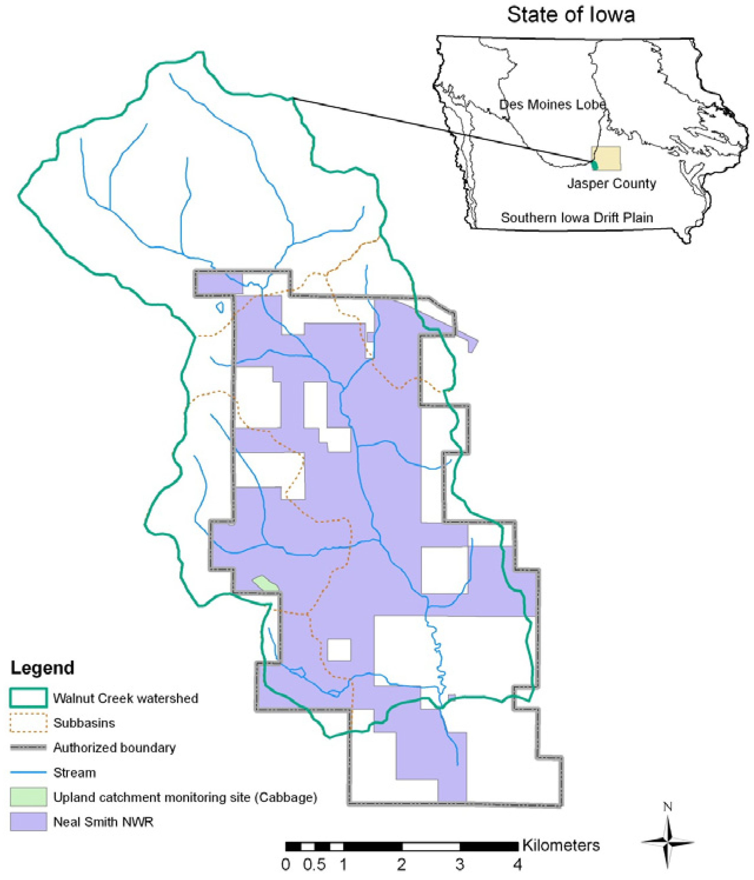
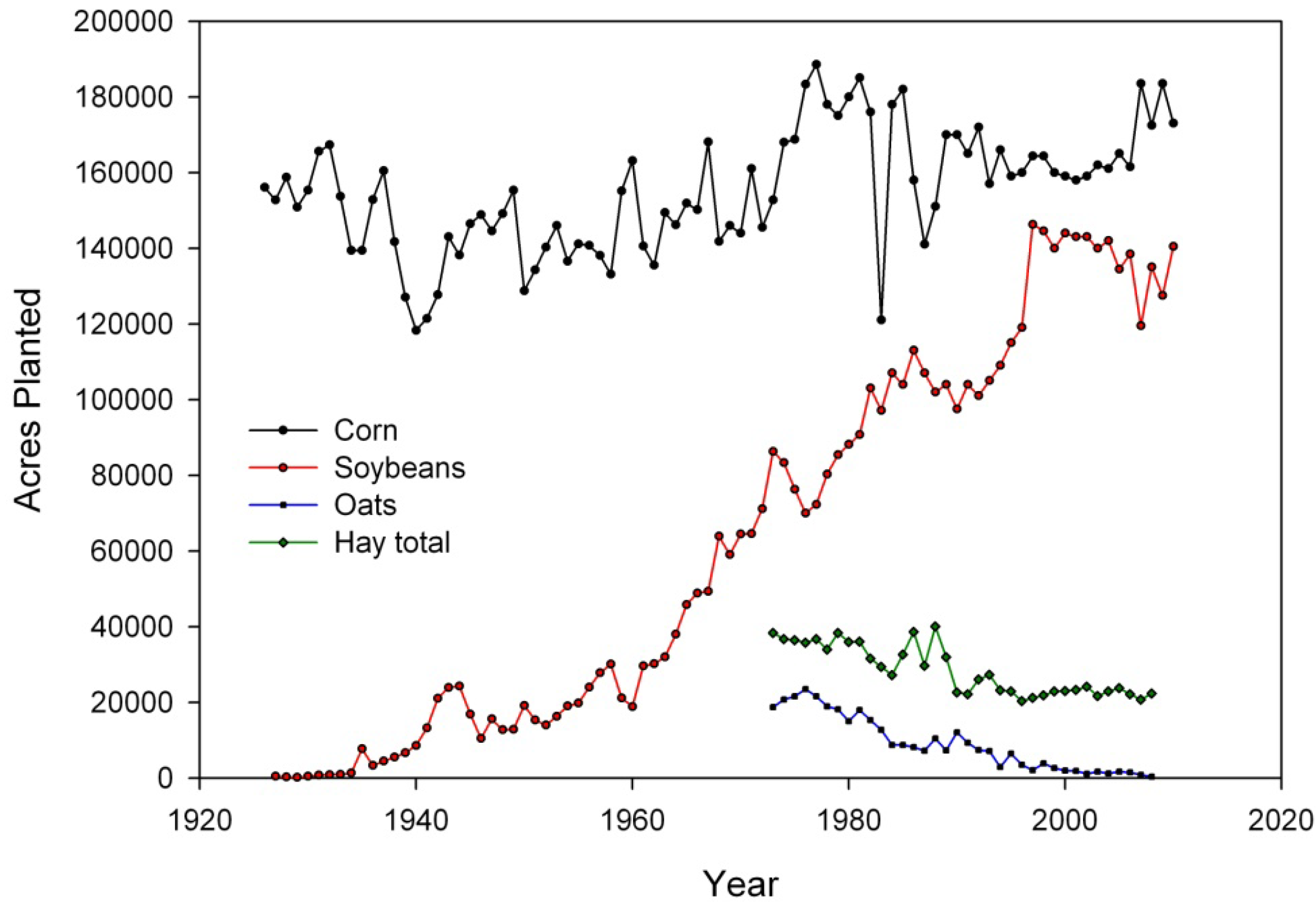
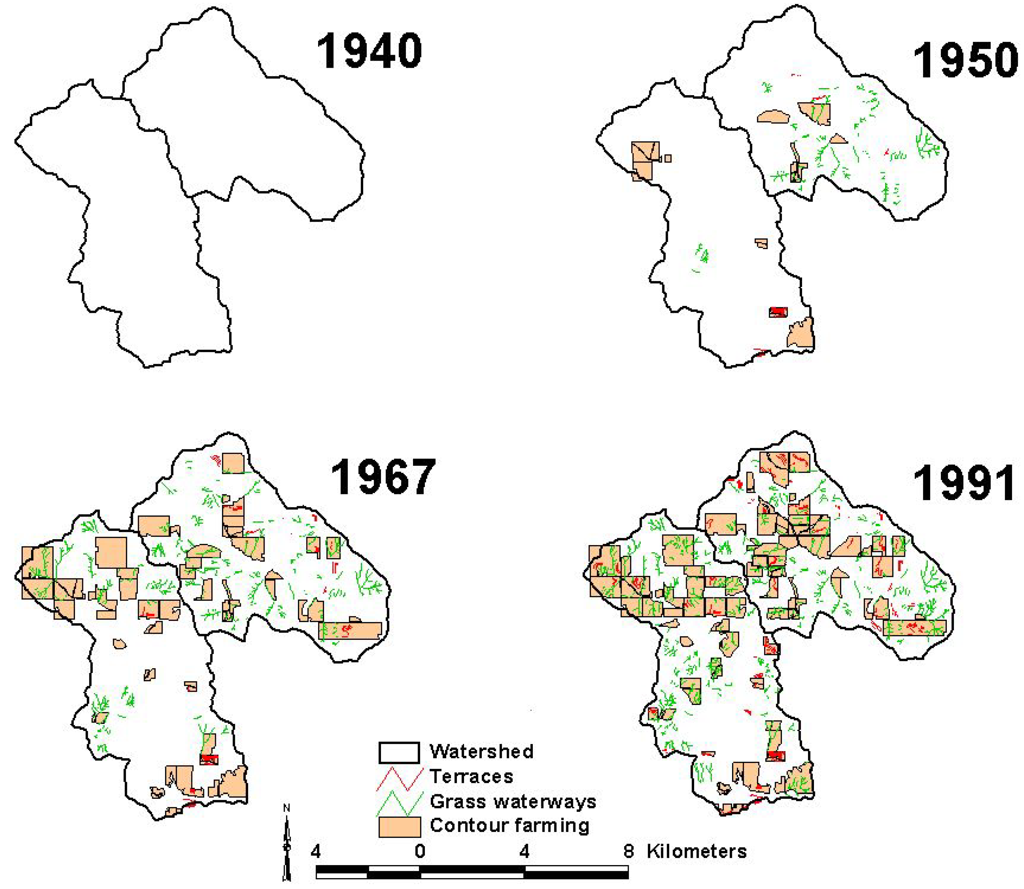
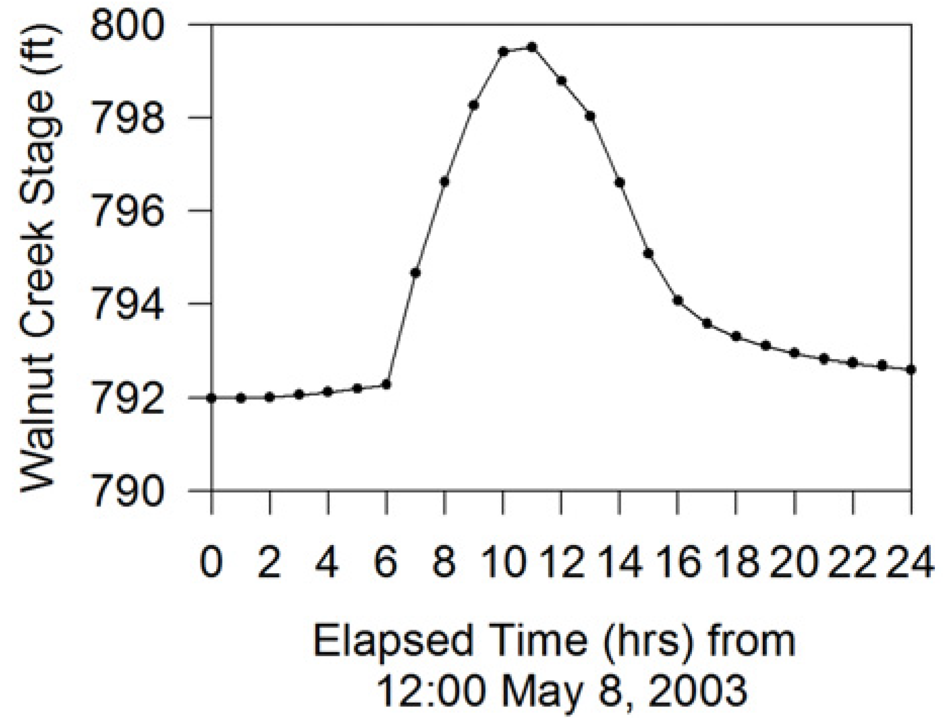
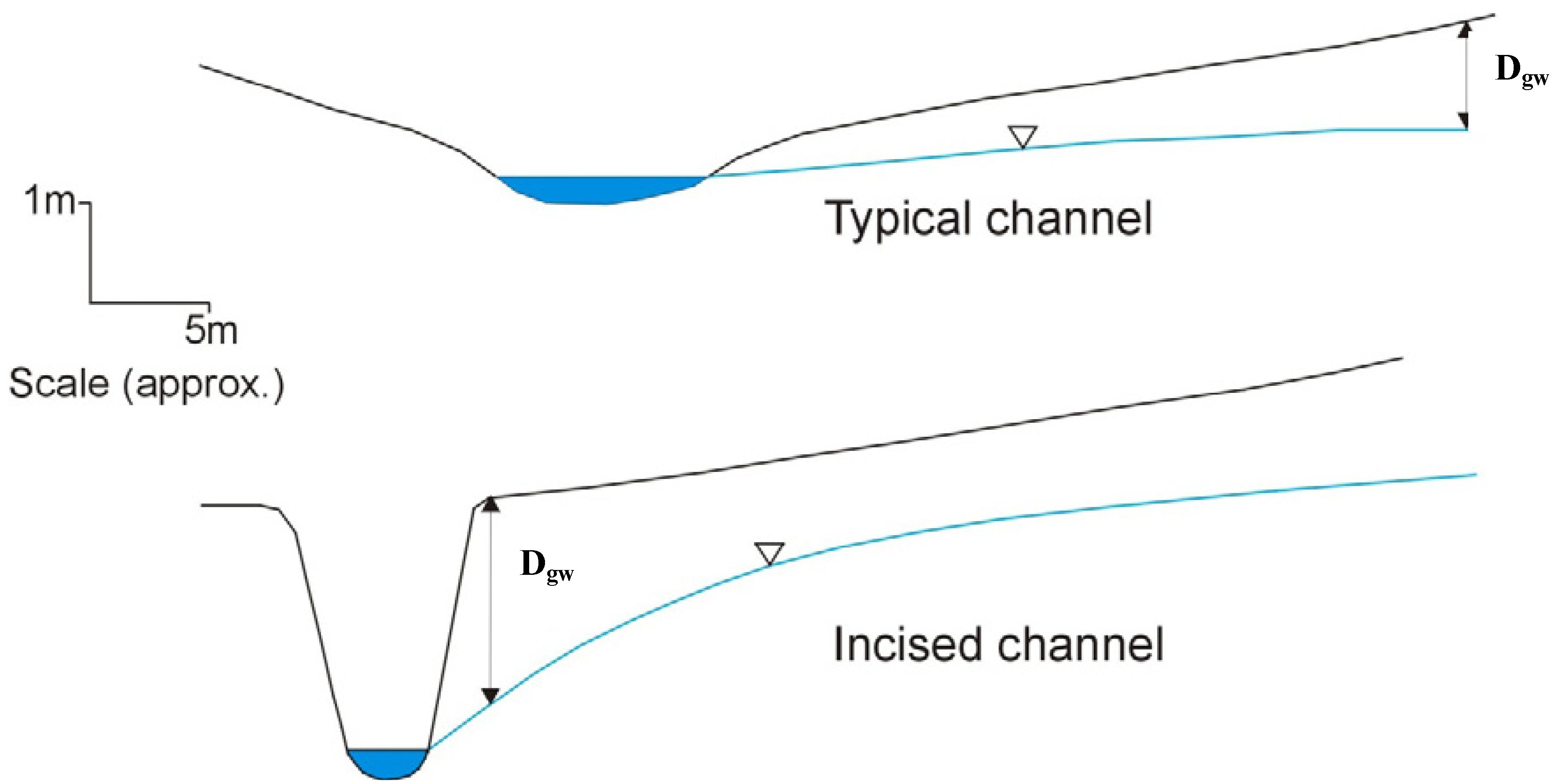
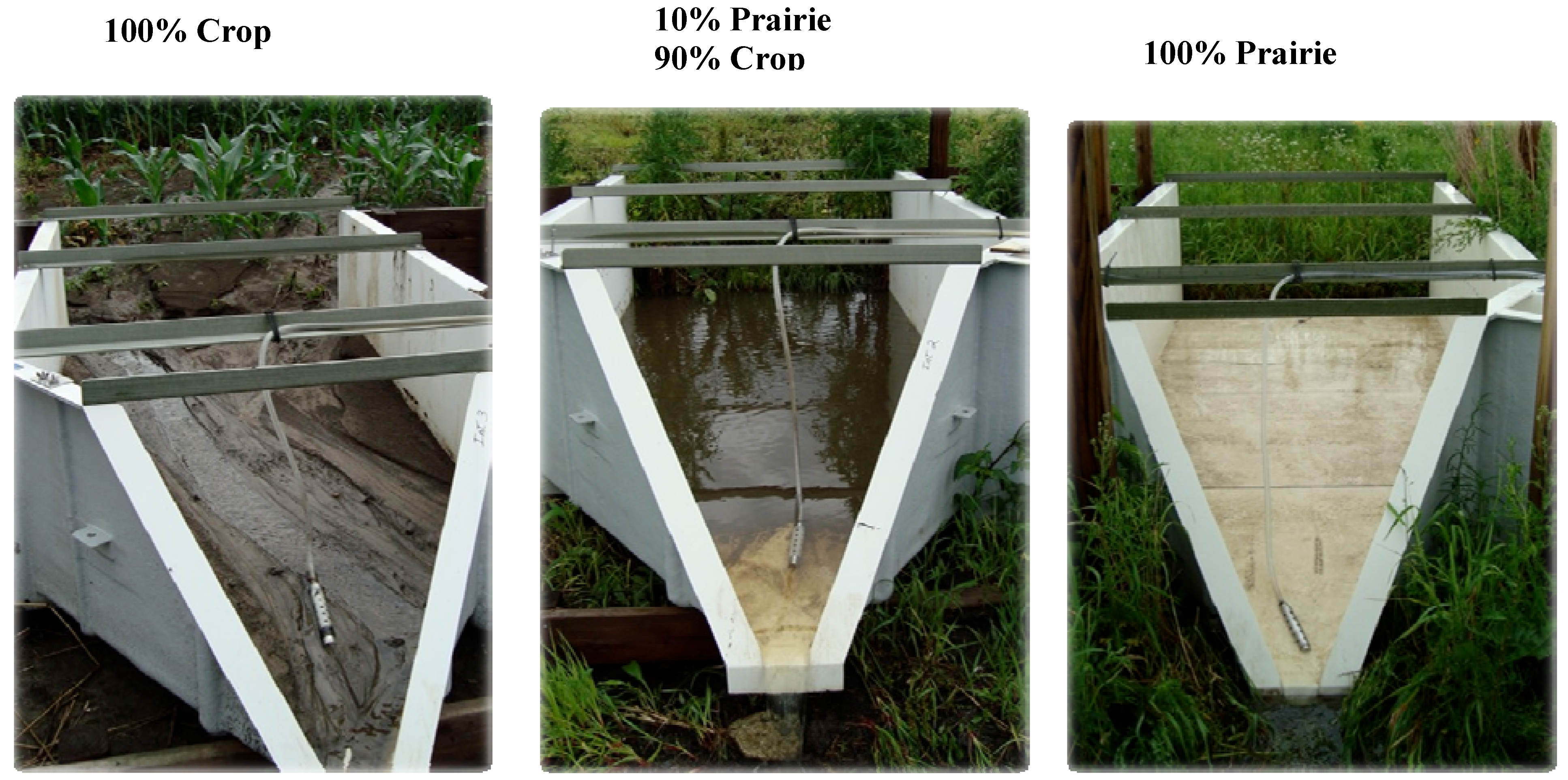
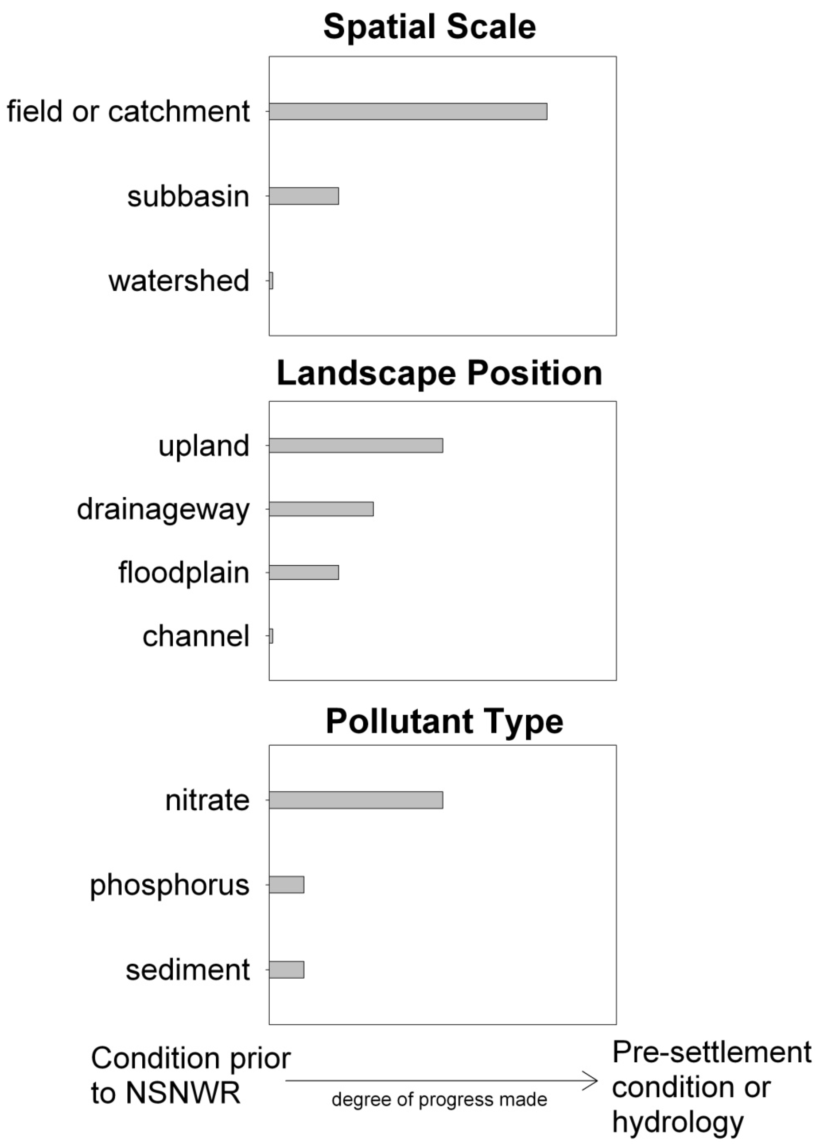
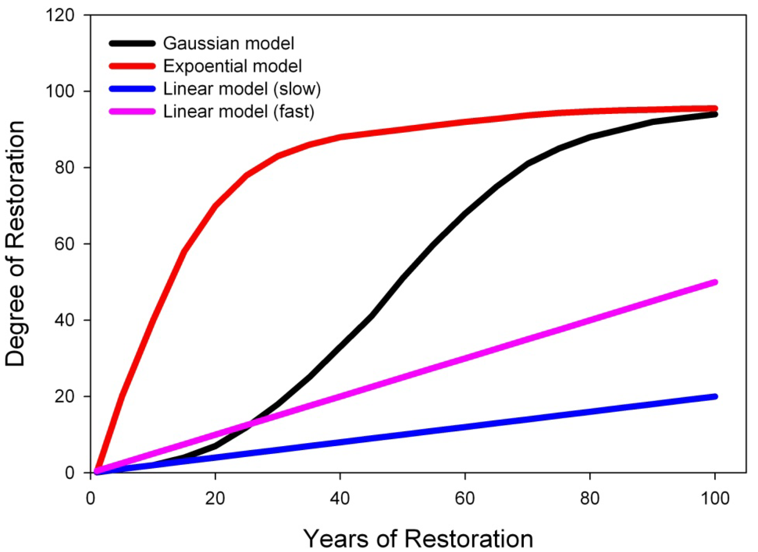


