Adaptation to New Climate by an Old Strategy? Modeling Sedentary and Mobile Pastoralism in Semi-Arid Morocco


Abstract
:1. Introduction
2. Methods

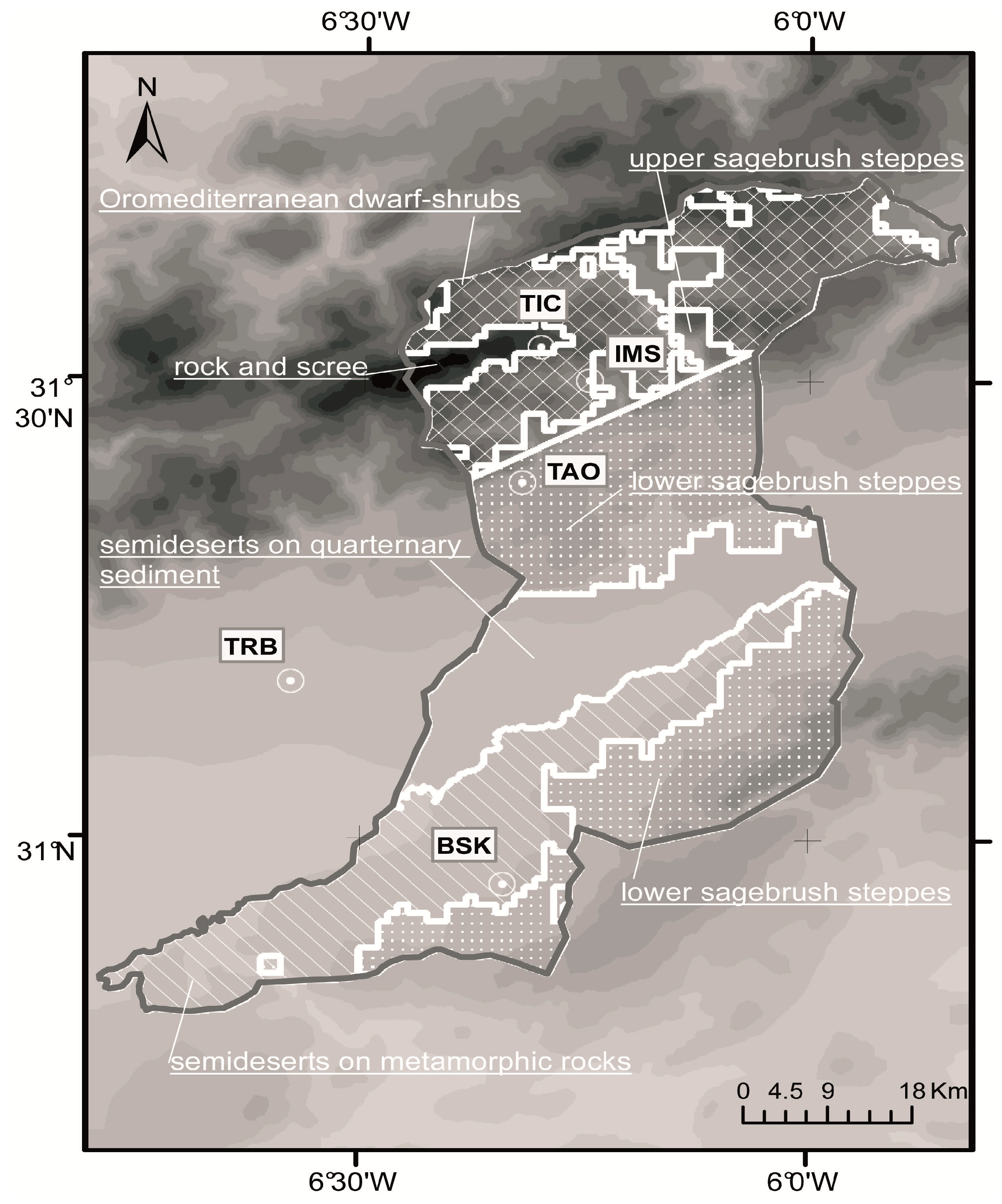
2.1. Study Region
2.2. Model Setup
2.3. Spatial Discretization and Herd Movements


| Test Site (Abbreviation) | Coordinates (lon/lat) | Altitude | Mean Annual Temperature | Mean Annual Precipitation | Mean AGPM (Grazed/Ungrazed) |
|---|---|---|---|---|---|
| Tichki (TIC) | −6.30289 31.53746 | 3174 m | 4.6 °C | 580 mm | 6.5 t∙ha−1 6.4 t∙ha−1 |
| Ameskar (IMS) | −6.24755 31.50144 | 2241 m | 13.3 °C | 307 mm | 2.6 t∙ha−1 2.8 t∙ha−1 |
| Taoujgalt (TAO) | −6.32203 31.38994 | 1960 m | 14.1 °C | 340 mm | 0.9 t∙ha−1 2.7 t∙ha−1 |
| Trab Labied (TRB) | −6.57849 31.17099 | 1400 m | 19.1 °C | 144 mm | 0.2 t∙ha−1 0.5 t∙ha−1 |
| Bou Skour (BSK) | −6.33982 30.95166 | 1476 m | 19.3 °C | 139 mm | 1.5 t∙ha−1 1.6 t∙ha−1 |


2.4. Calibration and Validation


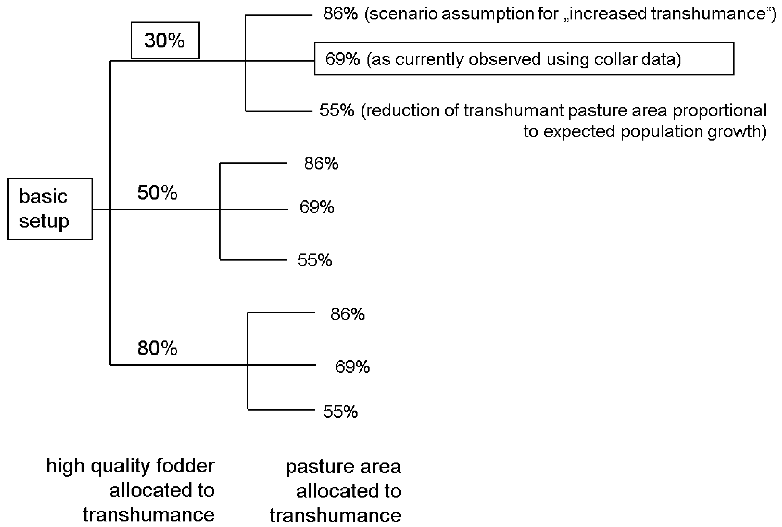
2.5. Experimental Setup
3. Results and Discussion
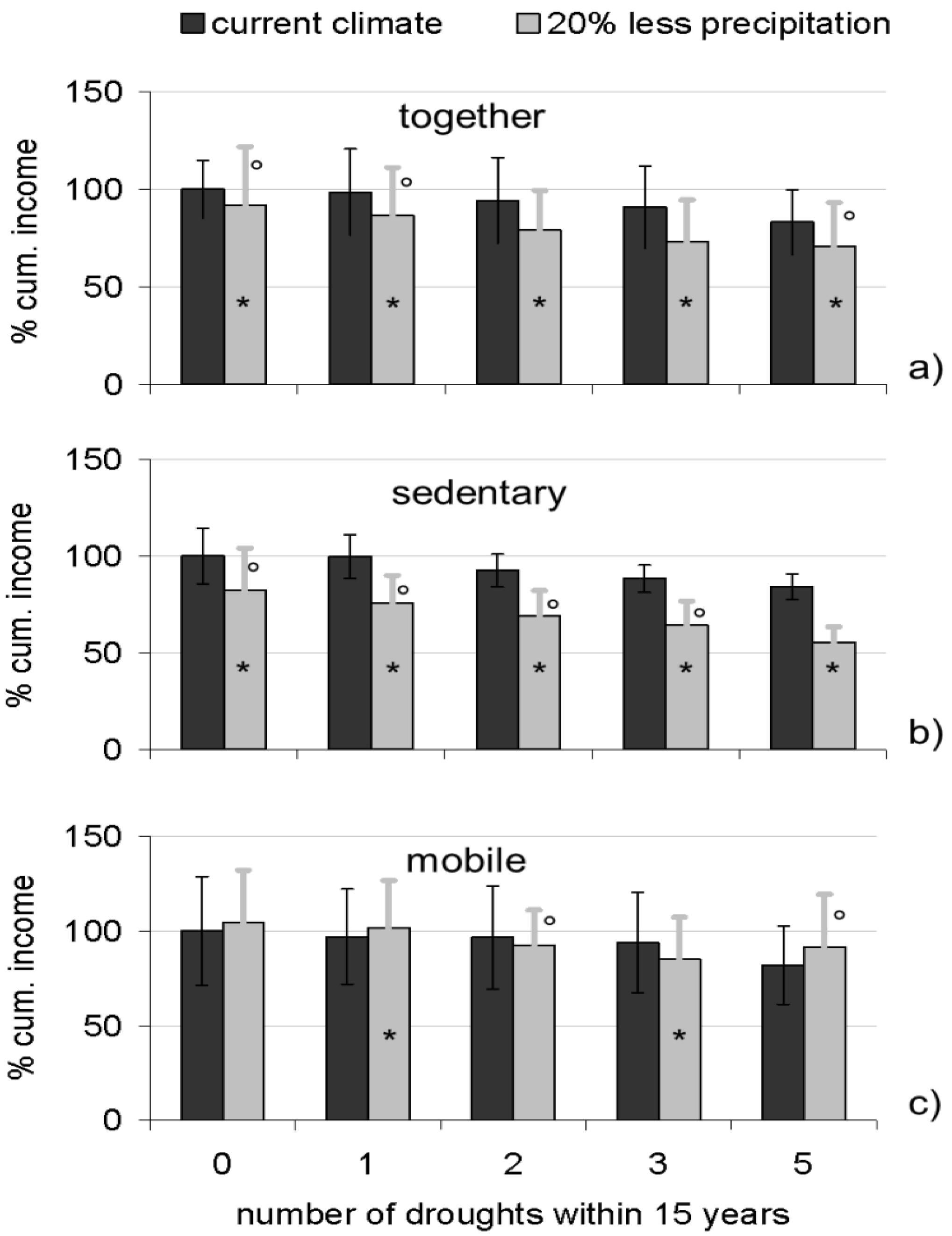
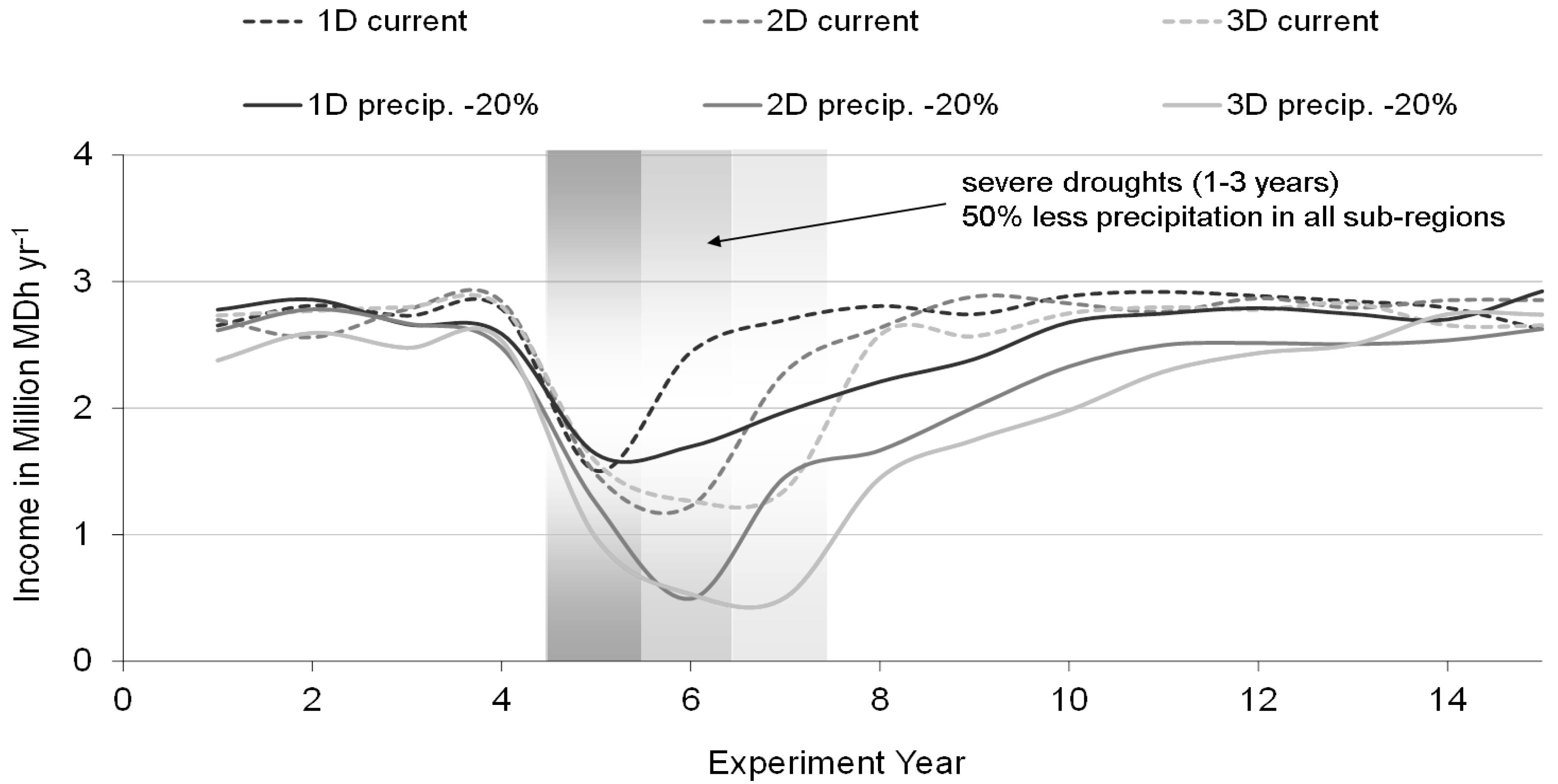
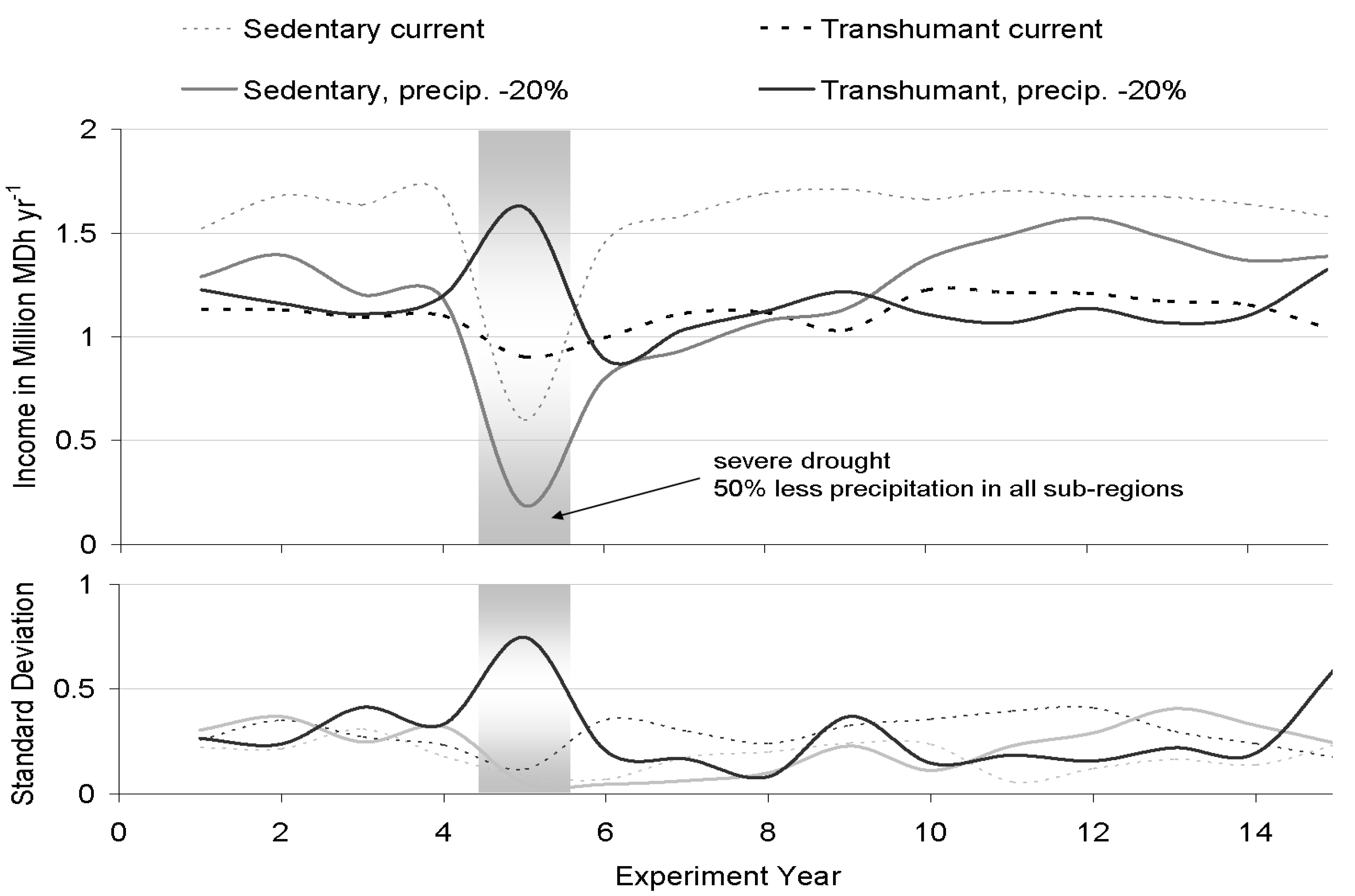
3.1. Effects of Reduced Precipitation


3.2. Options for Adaptation
| Area Partition | Trh 86% | Trh 69% | Trh 55% | ||||||
|---|---|---|---|---|---|---|---|---|---|
| Fodder (Trh) | 80% | 50% | 30% | 80% | 50% | 30% | 80% | 50% | 30% |
| Current Climate | |||||||||
| ND15 | I | II | III | ||||||
| 1D15 | I | III | II | ||||||
| 2D15 | III | I | II | ||||||
| 3D15 | III | II | I | ||||||
| RD15 | III | I | II | ||||||
| Precipitation −20% | |||||||||
| ND15 | III | I | II | ||||||
| 1D15 | II | III | I | ||||||
| 2D15 | II | III | I | ||||||
| 3D15 | II | III | I | ||||||
| RD15 | II | III | I | ||||||


3.3. Model Limitations
4. Conclusions
Acknowledgments
Author Contributions
Conflicts of Interest
References
- Thornton, P.K.; van de Steeg, J.; Notenbaert, A.; Herrero, M. The impacts of climate change on livestock and livestock systems in developing countries: A review of what we know and what we need to know. Agric. Syst. 2009, 101, 113–127. [Google Scholar] [CrossRef]
- Millennium Ecosystem Assessment. Ecosystems and Human Well Being: Synthesis; Island Press: Washington, DC, USA, 2005. [Google Scholar]
- Intergovernmental Panel on Climate Change (IPCC). Contribution of Working Group I to the Fourth Assessment Report of the Intergovernmental Panel on Climate Change; Cambridge University Press: Cambridge, UK, 2007. [Google Scholar]
- Paeth, H.; Born, K.; Girmes, R.; Podzun, R.; Jacob, D. Regional climate change in tropical and northern Africa due to greenhouse forcing and land use changes. J. Clim. 2009, 22, 114–132. [Google Scholar] [CrossRef]
- Sillmann, J.; Roeckner, E. Indices for extreme events in projections of anthropogenic climate change. Clim. Chang. 2008, 86, 83–104. [Google Scholar] [CrossRef]
- Schilling, J.; Freier, K.; Hertig, E.; Scheffran, J. Climate change, vulnerability and adaptation in North Africa with focus on Morocco. Agric., Ecosyst. Environ. 2012, 156, 12–26. [Google Scholar] [CrossRef]
- Breuer, I. Marketing from the margins: The Ilmichan pastoralists of the Pre-Saharra. In Pastoral Marocco—Globalizing Scapes of Mobility and Insecurity; Gertel, J., Breuer, I., Eds.; Reichert: Wiesbaden, Germany, 2007; pp. 117–132. [Google Scholar]
- Davis, D.K. Neoliberalism, environmentalism, and agricultural restructuring in Morocco. Geogr. J. 2006, 172, 88–105. [Google Scholar]
- Niamir-Fuller, M. Managing mobility in African rangelands. In The Legitimization of Transhumance; Intermediate Technology Publications: London, UK, 1999; pp. 18–46. [Google Scholar]
- Werner, J. Pastoral livelihood strategies in the Draa and the Souss. In Pastoral Marocco—Globalizing Scapes of Mobility and Insecurity; Gertel, J., Breuer, I., Eds.; Reichert: Wiesbaden, Germany, 2007; pp. 181–192. [Google Scholar]
- Breuer, I. Livelihood security and mobility in the High Atlas Mountains. In Pastoral Marocco—Globalizing Scapes of Mobility and Insecurity; Gertel, J., Breuer, I., Eds.; Reichert: Wiesbaden, Germany, 2007; pp. 165–179. [Google Scholar]
- Casciarri, B. Coping with shrinking spaces: The Ait Unzar Pastoralists of south-eastern Morocco. In Nomadic Societies in the Middle Eastand North Africa: Entering the 21st Century; Chatty, D., Ed.; Brill: Leiden, The Netherland, 2006; pp. 393–430. [Google Scholar]
- Freier, K.; Bruggemann, R.; Scheffran, J.; Finckh, M.; Schneider, U. Assessing the predictability of future livelihood strategies of pastoralists in semi-arid Morocco under climate change. Technol. Forecast. Soc. Chang. 2012, 79, 371–382. [Google Scholar] [CrossRef]
- Schlüter, M.; McAllister, R.R.J.; Arlinghaus, R.; Bunnefeld, N.; Eisenack, K.; Hölker, F.; Milner-Gulland, E.J.; Müller, B.; Nicholson, E.; Quaas, M.; et al. New horizons for managing the environment: A review of coupled social-ecological systems modeling. Nat. Resour. Model. 2012, 25, 219–272. [Google Scholar] [CrossRef]
- Dougill, A.J.; Fraser, E.D.G.; Reed, M.S. Anticipating vulnerability to climate change in dryland pastoral systems: using dynamic systems models for the Kalahari. Ecol. Soc. 2010, 15, 17. [Google Scholar]
- Lohmann, D.; Tietjen, B.; Blaum, N.; Joubert, D.F.; Jeltsch, F. Shifting thresholds and changing degradation patterns: Climate change effects on the simulated long-term response of a semi-arid savanna to grazing. J. Appl. Ecol. 2012, 49, 814–823. [Google Scholar] [CrossRef]
- McAllister, R.R.J. Livestock mobility in arid and semiarid Australia: Escaping variability in space. Rangel. J. 2012, 34, 139–147. [Google Scholar] [CrossRef]
- Müller, B.; Linstädter, A.; Frank, K.; Bollig, M.; Wissel, C. Learning from local knowledge: Modeling the pastoral-nomadic range management of the Himba, Namibia. Ecol. Appl. 2007, 17, 1857–1875. [Google Scholar] [CrossRef]
- Linstädter, A.; Baumann, G. Abiotic and biotic recovery pathways of arid rangelands: Lessons from the High Atlas Mountains, Morocco. CATENA 2013, 103, 3–15. [Google Scholar] [CrossRef]
- Akasbi, Z.; Oldeland, J.; Dengler, J.; Finckh, M. Social and ecological constraints on decision making by transhumant pastoralists: A case study from the Moroccan Atlas Mountains. J. Mt. Sci. 2012, 9, 307–321. [Google Scholar] [CrossRef]
- Linstädter, A.; Kemmerling, B.; Baumann, G.; Kirscht, H. The importance of being reliable—Local ecological knowledge and management of forage plants in a dryland pastoral system (Morocco). J. Arid. Environ. 2013, 95, 30–40. [Google Scholar] [CrossRef]
- Freier, K.; Schneider, U.; Finckh, M. Dynamic interactions between vegetation and land use in semi-arid Morocco: Using a Markov process for modeling rangelands under climate change. Agric. Ecosyst. Environ. 2011, 140, 462–472. [Google Scholar] [CrossRef]
- Dominguez, P.; Bourbouze, A.; Demay, S.; Genin, D.; Kosoy, N. Diverse ecological, economic and socio-cultural values of a traditional common natural resource management system in the Moroccan High Atlas: The Aït Ikiss Tagdalts. Environ. Values 2012, 21, 277–296. [Google Scholar] [CrossRef]
- Martin, R.; Müller, B.; Linstädter, A.; Frank, K. How much climate change can pastoral livelihoods tolerate? Modelling rangeland use and evaluating risk. Glob. Environ. Chang. 2013, 24, 183–192. [Google Scholar]
- BIOTA Maroc. Available online: http://www.biota-africa.org (accessed on 16 March 2011).
- IMPETUS. Available online: http://www.impetus.uni-koelln.de/en (accessed on 16 March 2011).
- Schulz, O.; Finckh, M.; Goldbach, H. Hydro-meteorological measurements in the Drâa catchment. In Impacts of Global Change on the Hydrological Cycle in West and Northwest Africa; Speth, P., Christoph, M., Diekkrüger, B., Eds.; Springer: Heidelberg, Germany, 2010; pp. 122–131. [Google Scholar]
- Finckh, M.; Goldbach, H. Vegetation dynamics under climate stress and land use pressure in the Drâa catchment. In Impacts of Global Change on the Hydrological Cycle in West and Northwest Africa; Speth, P., Christoph, M., Diekkrüger, B., Eds.; Springer: Heidelberg, Germany, 2010; pp. 274–281. [Google Scholar]
- Rachik, H. Nomads: But how? In Pastoral Marocco—Globalizing Scapes of Mobility and Insecurity; Gertel, J., Breuer, I., Eds.; Reichert: Wiesbaden, Germany, 2007; pp. 211–252. [Google Scholar]
- Akasbi, Z.; Oldeland, J.; Dengler, J.; Finckh, M. Analysis of GPS trajectories to assess goat grazing pattern and intensity in southern Morocco. Rangel. J. 2012, 34, 415–427. [Google Scholar] [CrossRef]
- Rössler, M.; Kirscht, H.; Rademacher, C.; Platt, S. Demographic development in Southern Morocco: Migration, urbanization, and the role of institutions in resource management. In Impacts of Global Change on the Hydrological Cycle in West and Northwest Africa; Speth, P., Christoph, M., Diekkrüger, B., Eds.; Springer: Heidelberg, Germany, 2010; pp. 305–314. [Google Scholar]
- Rössler, M.; Kirscht, H.; Rademacher, C.; Platt, S.; Kemmerling, B.; Linstädter, A. Migration and resource management in the Drâa Valley, Southern Morocco. In Impacts of Global Change on the Hydrological Cycle in West and Northwest Africa; Speth, P., Christoph, M., Diekkrüger, B., Eds.; Springer: Heidelberg, Germany, 2010; pp. 634–647. [Google Scholar]
- Chiche, J. History of mobility and livestock production in Morocco. In Pastoral Marocco—Globalizing Scapes of Mobility and Insecurity; Gertel, J., Breuer, I., Eds.; Reichert: Wiesbaden, Germany, 2007; pp. 31–59. [Google Scholar]
- Williams, J.R.; Jones, C.A.; Kiniry, J.R.; Spanel, D.A. The EPIC crop growth-model. Trans. Asae 1989, 32, 497–511. [Google Scholar] [CrossRef]
- Barbier, B.; Bergeron, G. Natural Resource Management in the Hillsides of Honduras—Bioeconomic Modeling at the Microwatershed Level; Research Report No. 123; International Food Policy Research Institute: Washington, DC, USA, 2001. [Google Scholar]
- Le Houerou, H. Browse in Northern Africa. In Browse in Africa: The Current State of Knowledge; International Livestock Center for Africa: Addis Ababa, Ethiopia, 1980; pp. 55–82. [Google Scholar]
- Kirscht, H. Agricultural strategies: Irrigation management, risk diversion and crop rotation in Tichki. In IMPETUS Atlas Marokko—Research Results 2000–2007; Schulz, O., Judex, M., Eds.; IMPETUS Project: Köln/Cologne, Germany, 2008; pp. 73–74. [Google Scholar]
- Skalsky, R.; Tarasovicová, Z.; Balkovic, J.; Schmid, E.; Fuchs, M.; Moltchanova, E.; Kindermann, G.; Scholtz, P. GEO-BENE Global Database for Bio-Physical Modeling v. 1.0. Concepts, Methodologies and Data. Available online: www.geo-bene.eu (accessed on 16 March 2011).
- Nash, J.; Sutcliffe, J. River flow forecasting through conceptual models part I—A discussion of principles. J. Hydrol. 1970, 10, 282–290. [Google Scholar] [CrossRef]
- Royaume du Maroc, Haut Commissariat au Plan, Centre de Lecture Automatique de Documents (CLAD). Recensement Général de la Population de de l’Habitat 2004—Indicateurs Socio-Démographiques, Conditions de vie et Développement Humain—Données Statistiques et Cartographiques; [CD-ROM]; CLAD: Rabat, Morocco, 2004. [Google Scholar]
- Akasbi, Z. Personal communication, University of Hamburg: Hamburg, Germany, 2009.
- Skees, J.; Gober, S.; Varangis, P.; Lester, R.; Kalavakonda, V. Developing Rainfall-Based Index Insurance in Morocco; Policy Research Working Paper 2577; The World Bank: Washington, DC, USA, 2001. [Google Scholar]
- Blench, R.; Marriage, Z. Drought and Livestock in Semi-Arid Africa and Southwest Asia; Working Paper; Overseas Development Institute: London, UK, 1999. [Google Scholar]
- Hazell, P.; Oram, P.; Chaherli, N. Managing Droughts in the Low-Rainfall Areas of the Middle East and North Africa; EPTD Discussion Paper; International Food Policy Research Institute: Washington, DC, USA, 2001. [Google Scholar]
- Illius, A.W.; O’Connor, T.G. On the relevance of nonequilibrium concepts to arid and semiarid grazing systems. Ecol. Appl. 1999, 9, 798–813. [Google Scholar] [CrossRef]
- Vetter, S. Rangelands at equilibrium and non-equilibrium: Recent developments in the debate. J. Arid Environ. 2005, 62, 321–341. [Google Scholar] [CrossRef]
- Morton, J.; Barton, D. Destocking as a drought-mitigation strategy: Clarifying rationales and answering critiques. Disasters 2002, 26, 213–228. [Google Scholar] [CrossRef]
- Linstädter, A.; Baumann, G.; Born, K.; Diekkrüger, B.; Fritzsche, P.; Kirscht, H.; Klose, A. Land use and land cover in Southern Morocco: Managing unpredictable resources and extreme events. In Impacts of Global Change on the Hydrological Cycle in West and Northwest Africa; Speth, P., Christoph, M., Diekkrüger, B., Eds.; Springer: Heidelberg, Germany, 2010; pp. 612–633. [Google Scholar]
- Golley, F.B. Energy values of ecological materials. Ecology 1961, 42, 581–584. [Google Scholar] [CrossRef]
- Mattson, W.J. Herbivory in relation to plant nitrogen-content. Annu. Rev. Ecol. Syst. 1980, 11, 119–161. [Google Scholar]
- Roth, A. Impact of Climate Change and Stocking Rates on Pasture Systems in SE Morocco—An Application of the SAVANNA Ecosystem Model. Ph.D. Thesis, University of Bonn, Bonn, Germany, 2009; p. 211. [Google Scholar]
- United Nations Development Programme (UNDP). Country Case Study—Morocco: Transhumance for Biodiversity Conservation in the Southern High Atlas; Project ID 852; UNDP: New York, NY, USA, 2010. [Google Scholar]
- Werner, J. Pasteurs entre Marginalisation, Entrepreneuriat et Conflits. Ph.D. Thesis, Humboldt Universität Berlin, Berlin, Germany, 2004; p. 169. [Google Scholar]
© 2014 by the authors; licensee MDPI, Basel, Switzerland. This article is an open access article distributed under the terms and conditions of the Creative Commons Attribution license (http://creativecommons.org/licenses/by/3.0/).
Share and Cite
Freier, K.P.; Finckh, M.; Schneider, U.A. Adaptation to New Climate by an Old Strategy? Modeling Sedentary and Mobile Pastoralism in Semi-Arid Morocco. Land 2014, 3, 917-940. https://doi.org/10.3390/land3030917
Freier KP, Finckh M, Schneider UA. Adaptation to New Climate by an Old Strategy? Modeling Sedentary and Mobile Pastoralism in Semi-Arid Morocco. Land. 2014; 3(3):917-940. https://doi.org/10.3390/land3030917
Chicago/Turabian StyleFreier, Korbinian P., Manfred Finckh, and Uwe A. Schneider. 2014. "Adaptation to New Climate by an Old Strategy? Modeling Sedentary and Mobile Pastoralism in Semi-Arid Morocco" Land 3, no. 3: 917-940. https://doi.org/10.3390/land3030917