Linking Environmental Magnetism to Geochemical Studies and Management of Trace Metals. Examples from Fluvial, Estuarine and Marine Systems

Abstract
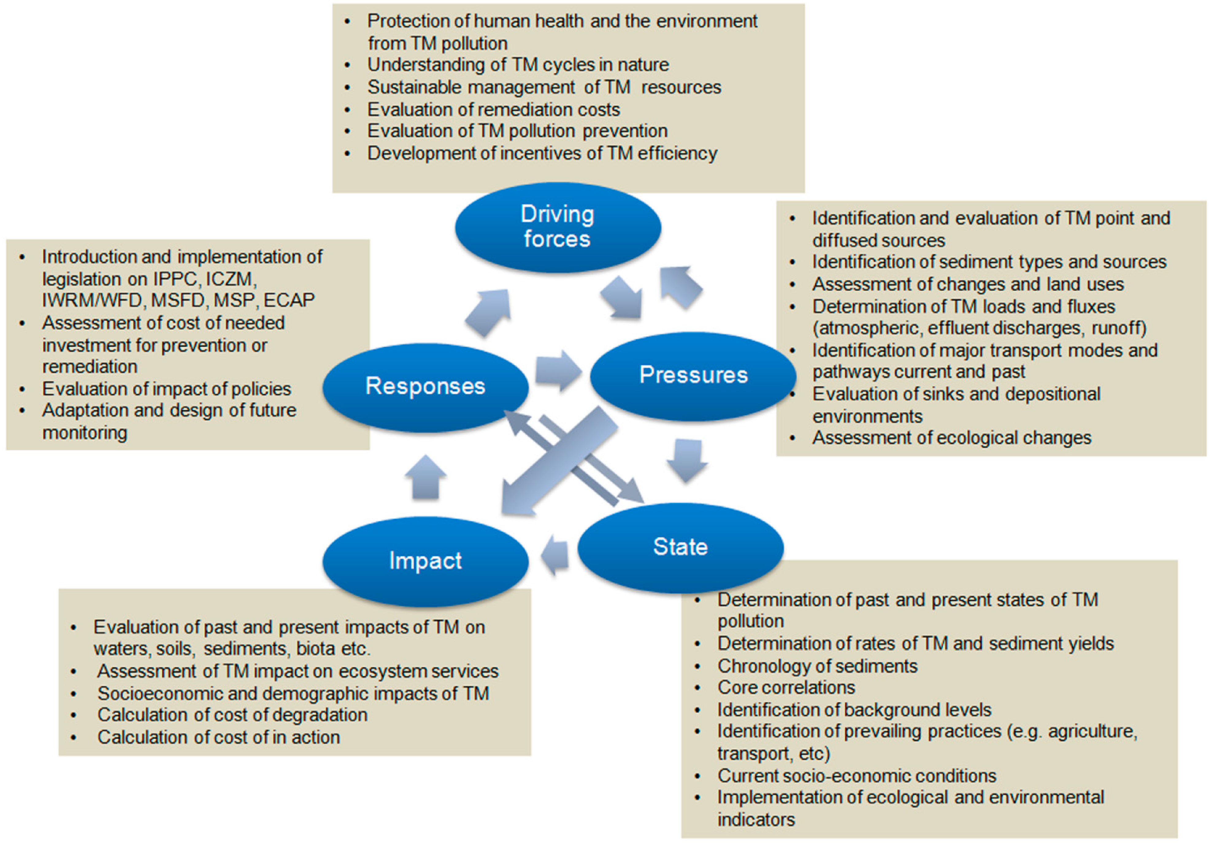
:1. Introduction
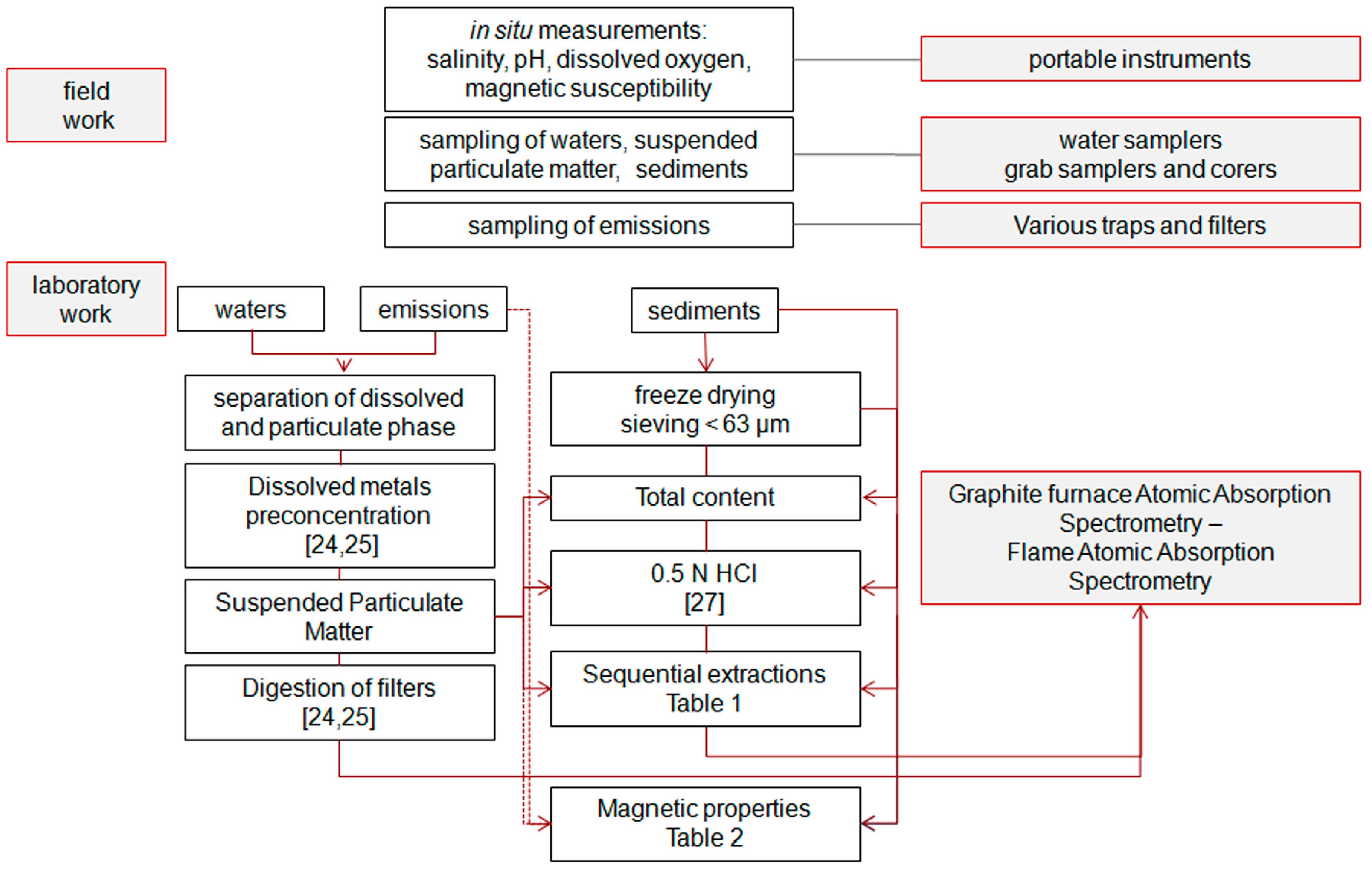
2. Materials and Methods


| Scheme | Extraction Step (fi) | Reagents | Fraction of Metals |
|---|---|---|---|
| SES (1) | 1 | MgCl2 | Easily exchangeable |
| 2 | CH3COOH + NH2OH·HCl | Non-exchangeable, non-lattice held, inorganic | |
| 3 | EDTA | Organic | |
| 4 | HNO3-HClO4 | Pseudo-residual, lattice-held | |
| SES (2) | 1 | CH3COOH | Acid-soluble |
| 2 | NH2OH·HCl | Reducible | |
| 3 | H2O2/CH3COONH4 | Oxidizable | |
| 4 | HNO3-HF-HClO4 | Residual, lattice-held |
3. Tracing Pollution Sources, Dispersion Patterns, Evolution of the Impact and Background Levels for Environmental State
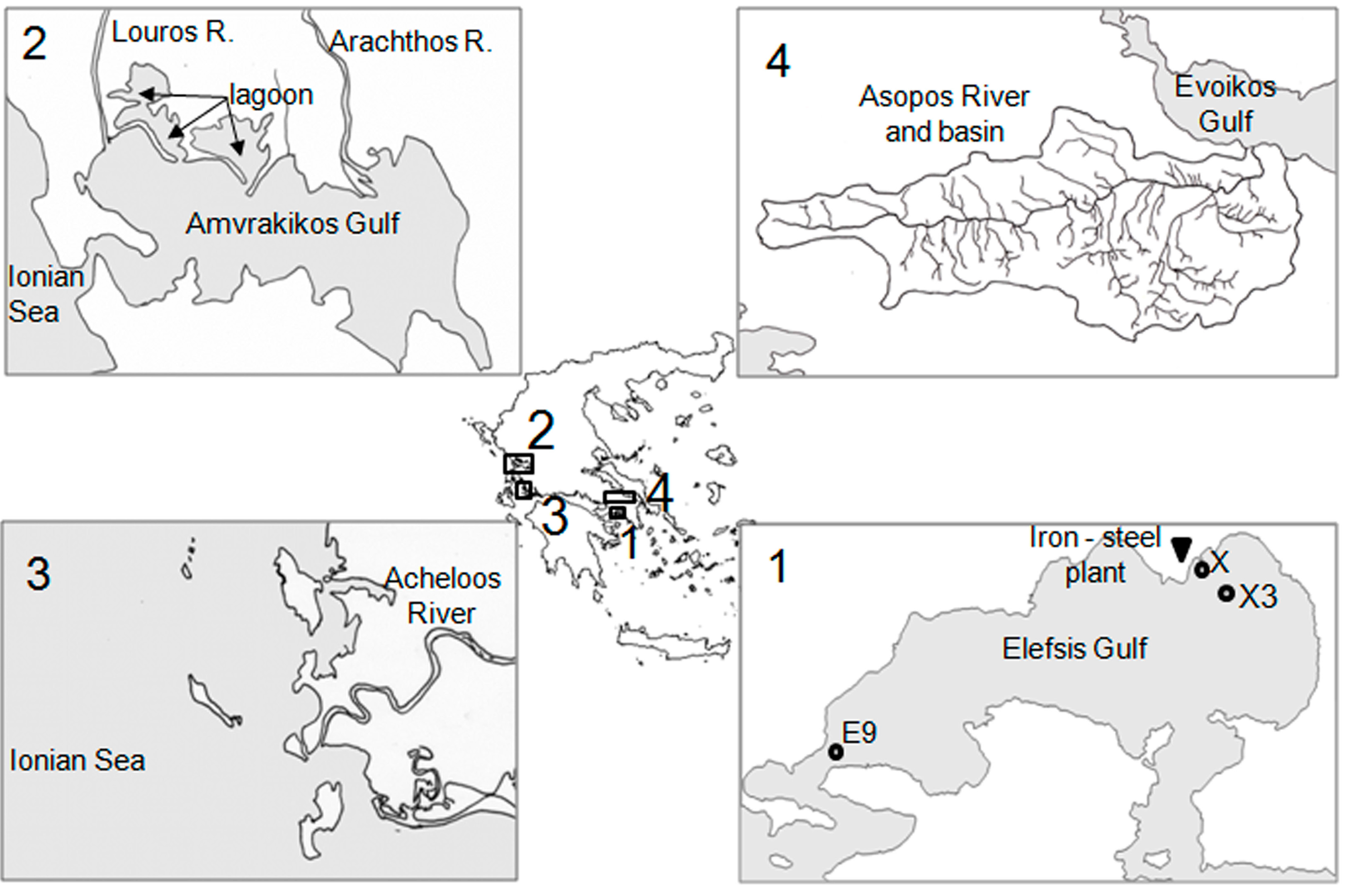
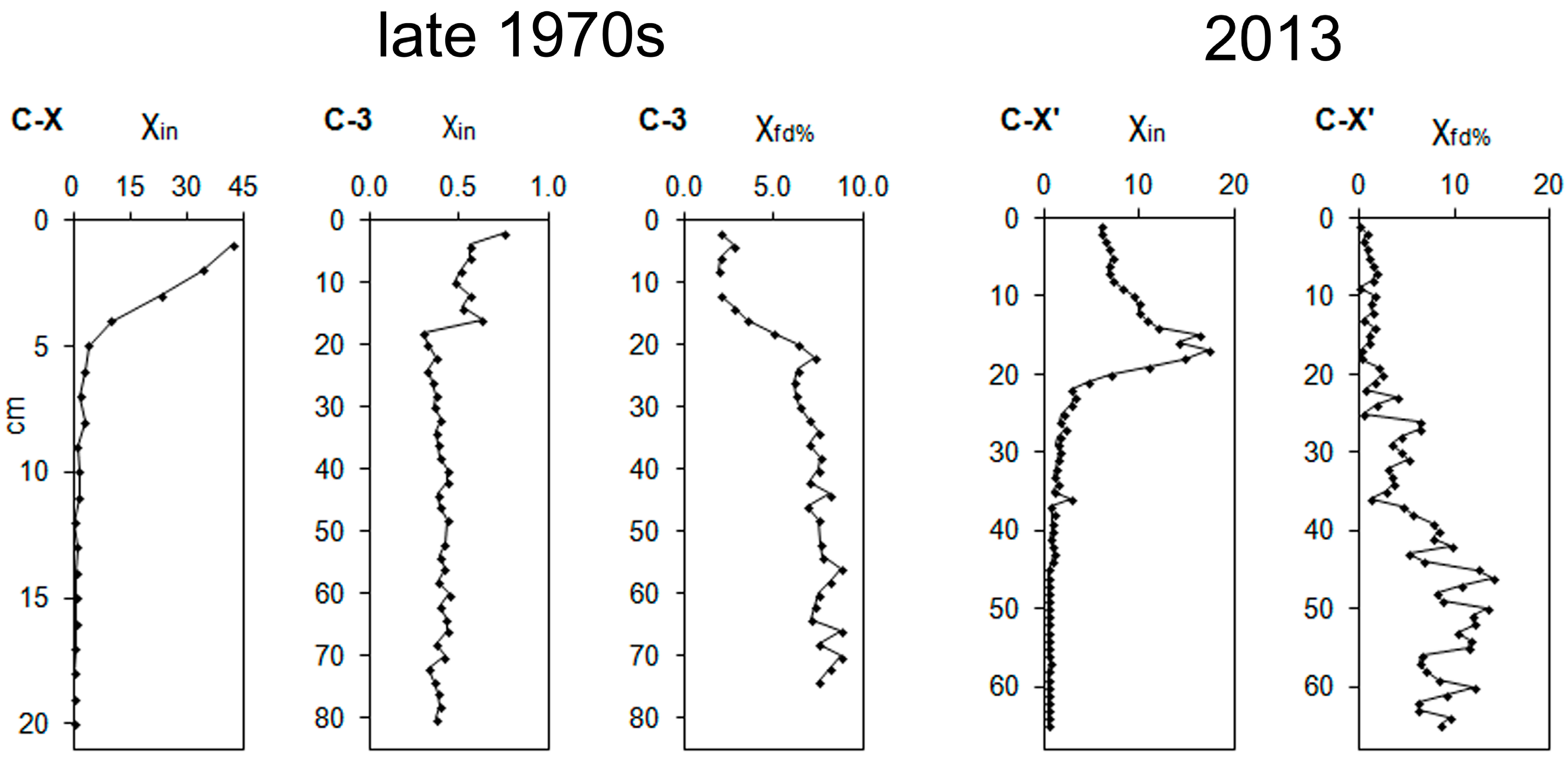
3.1. The Elefsis Gulf
| Parameter | Description |
|---|---|
| χin, k | Low-field or initial susceptibility is used as a proxy for the magnetic mineral concentration and is often equated to the concentration of ferrimagnetic minerals (e.g., magnetite). When the concentration of ferrimagnetics is low (i.e., <1 μg/g), then magnetic susceptibility will reflect the concentration of the magnetically weaker canted antiferromagnetic minerals (e.g., hematite, goethite) and/or non-remanence-carrying paramagnetic minerals (e.g., clay minerals) [34,35]. It is expressed on a volume-specific basis (k) or on a mass-specific basis (χin).In this study initial susceptibility was determined at a frequency of 0.465 kHz and is reported both on a mass specific base (in m3·kg−1) and on a volume specific base (dimensionless SI units). |
| χfd | Frequency dependent susceptibility. The variation of susceptibility between low and high frequency (in this study 0.465 kHz and 4.65 kHz). The parameter indicates the presence of ultrafine grains lying in the stable single domain/superparamagnetic boundary [17,36]. It is expressed on a volume (kfd) or mass specific base (χfd) or as a percentage of the χin (χfd%). |
| ARM | The Anhysteretic Remanent Magnetization (ARM) is acquired by placing a sample in a decreasing alternating field from a peak value (here AF = 100 mT) to zero. While the AF field decreases, the sample is subjected to a direct current bias field with a superimposed small biased direct current field (DC = 0.04 mT). ARM is sensitive to the concentration and the grain size of ferrimagnetic minerals. SD (Single Domain) particles have higher ARM intensities compared to MD (Multi Domain) particles [18,34]. |
| IRM, SIRM | Isothermal Remanent Magnetization is the magnetization acquired by a sample that is exposed to a DC magnetic field. The IRM increases with increasing applied field until the response is saturated and the sample acquires the Saturation IRM (SIRM). A field of 1 T is usually used, although such a field will not saturate canted antiferromagnetic minerals, which require fields in excess of 2.5 T. SIRM may reflect the concentration of magnetic minerals, but also responds to grain size variations and magnetic mineralogy [16,18]. It is expressed on a volume-specific base (in A·m−1) or on mass-specific base (in A·m2·kg−1). In this study the maximum applied field was 1 T and the imparted IRM is reported as SIRM. IRMs imparted at lower fields are reported as IRMx where x denotes the intensity of the field. |
| IRM−x,/IRMx, IRM−x/SIRM, S, Bcr, HARD, HIRM, SOFT, Modified L-ratio | Demagnetization parameters that are used to differentiate between ferrimagnetic and canted antiferromagnetic minerals, and between magnetic grain sizes. IRM−x are the IRMs remaining after applying one, or more reversed magnetic fields to a magnetized sample (up to saturation) in the opposite direction. The strength of the reversed field (mT) that is required to return a sample from its SIRM to zero is called the coercivity of remanence BCR. The loss of magnetization at −100 mT expressed as a ratio to SIRM (IRM−100/SIRM) is termed as the S ratio [37]. In the reverse field of −300 mT the HIRM (Hard IRM) parameter is obtained in a mass- specific basis [HIRM = (SIRM + IRM−300)/2] and as a percentage (%) [HARD = 100 × HIRM/SIRM]. HIRM is used as a measure of the concentration of high coercivity minerals, whereas HARD is a measure of the relative abundance of high coercivity minerals in a mixture with ferrimagnetic minerals [16]. In the reverse field of −20 mT the SOFT [= (SIRM − IRM−20)/2] and SOFT% [=100 × SOFT/SIRM] are acquired which are used as a proxy to MD ferrimagnetic grains [38]. The L-ratio was proposed by Liu et al. [39] to determine how coercivity changes affect HIRM. Variations of the L-ratio values indicate changes in the coercivity of hematite and goethite [16]. It is defined as L = HARD300 mT/HARD100 mT, and in this is obtained by DC demagnetization, which is equivalent to the original L-ratio (the ratio of the remanences after alternating field (AF) demagnetization of an IRM imparted in a 1 T field with a peak AF of 100 mT and 300 mT [40,41]. |


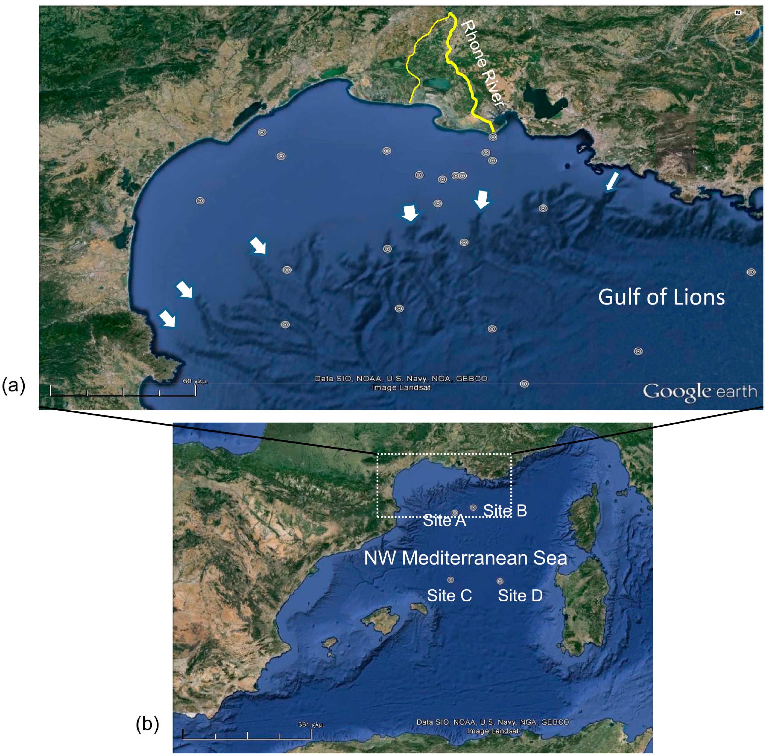
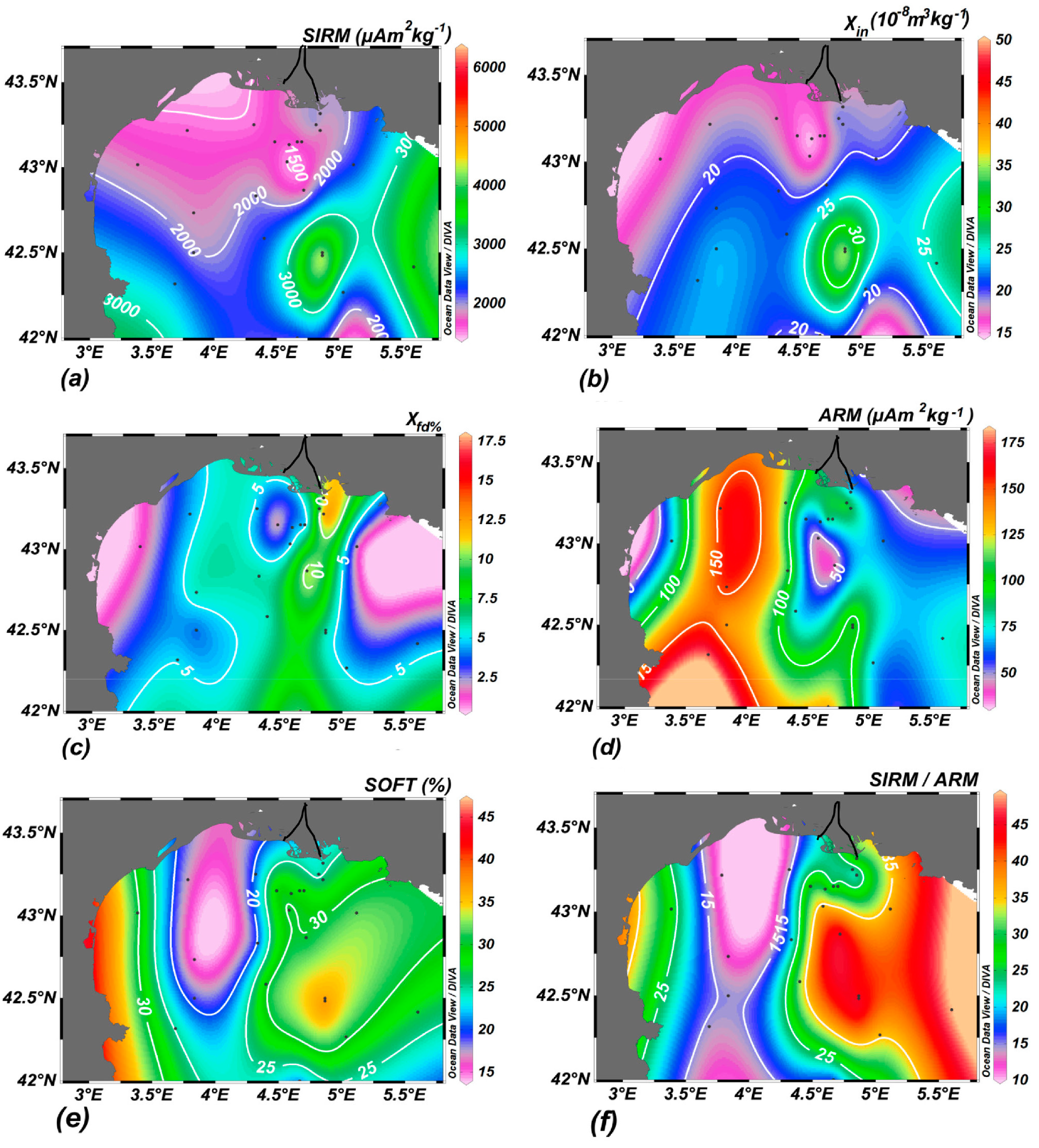
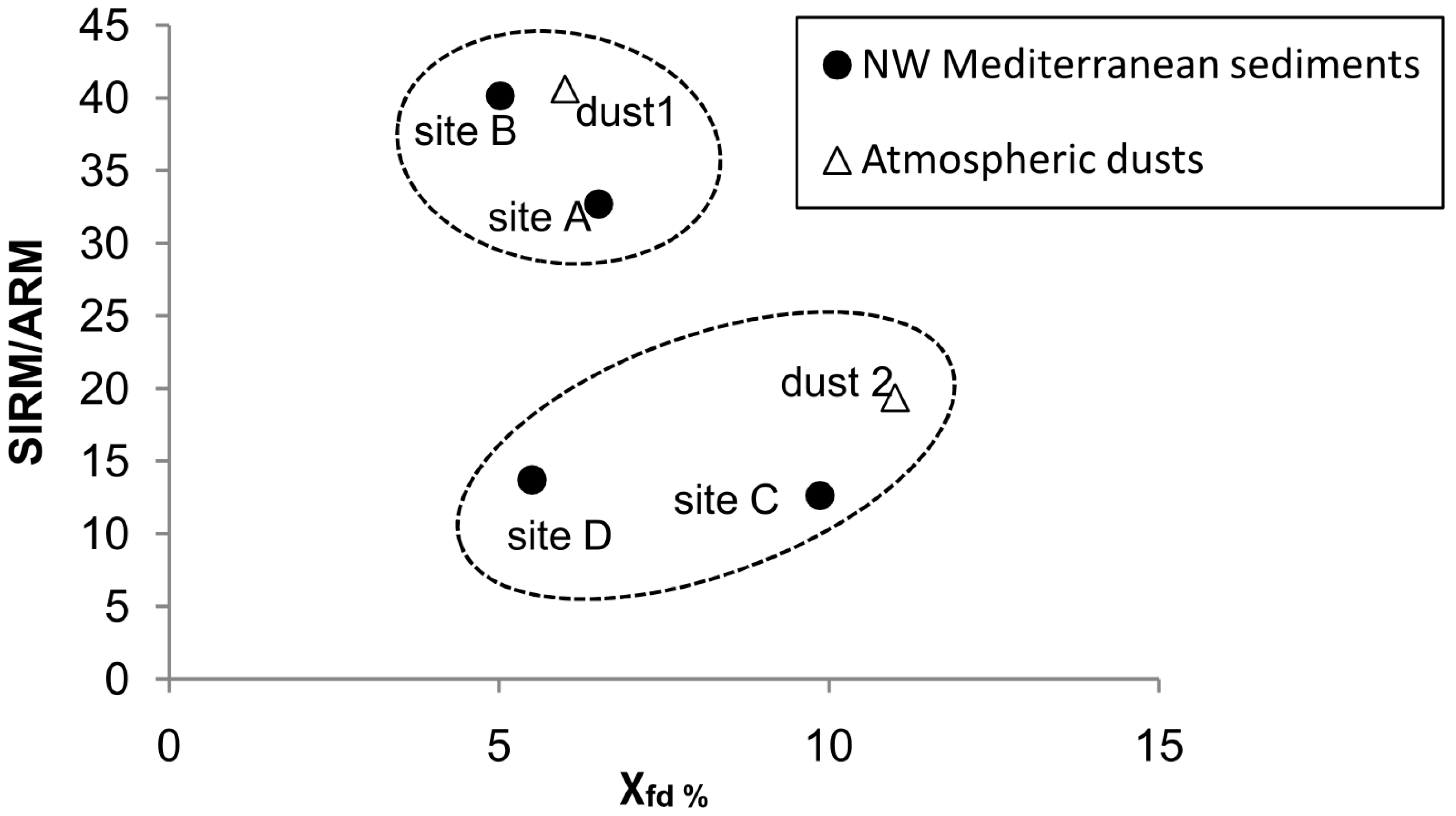
3.2. The Gulf of Lions


| Aerosol sample | χin (10−8 m3·kg−1) | χfd% | ARM (μA·m2·kg−1) | SIRM (μA·m2·kg−1) | SIRM/ARM | SIRM/χin (kA·m−1) | IRM−0.3T/SIRM |
|---|---|---|---|---|---|---|---|
| Dust 1 06/03/86 | 78 | 6 | 119 | 4836 | 41 | 6 | −0.19 |
| Dust 2 06/12/87 | 131 | 12 | 449 | 8706 | 19 | 7 | −0.10 |

4. Identification of Geochemical Processes and Transport Pathways from Sources to Sink
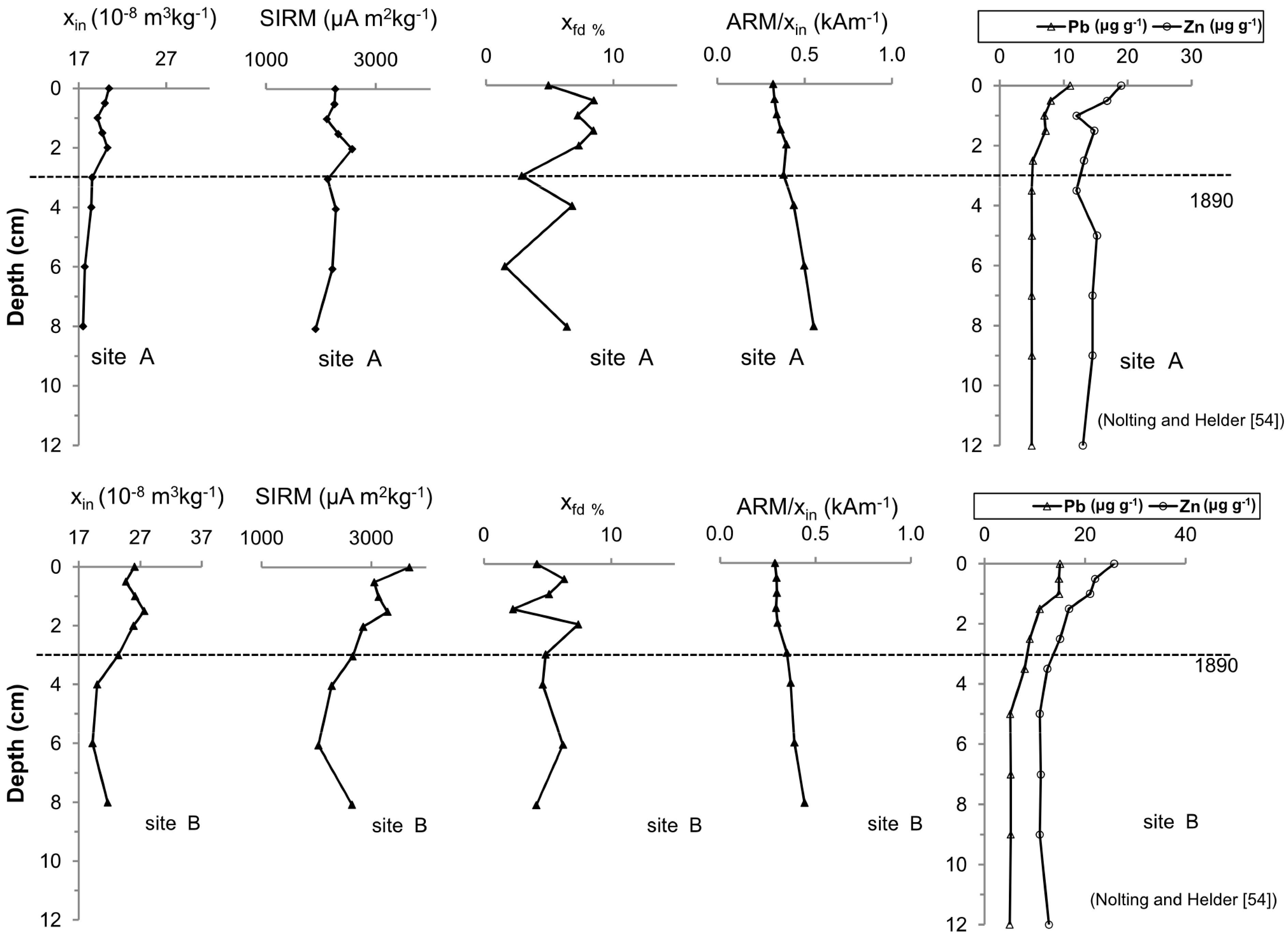
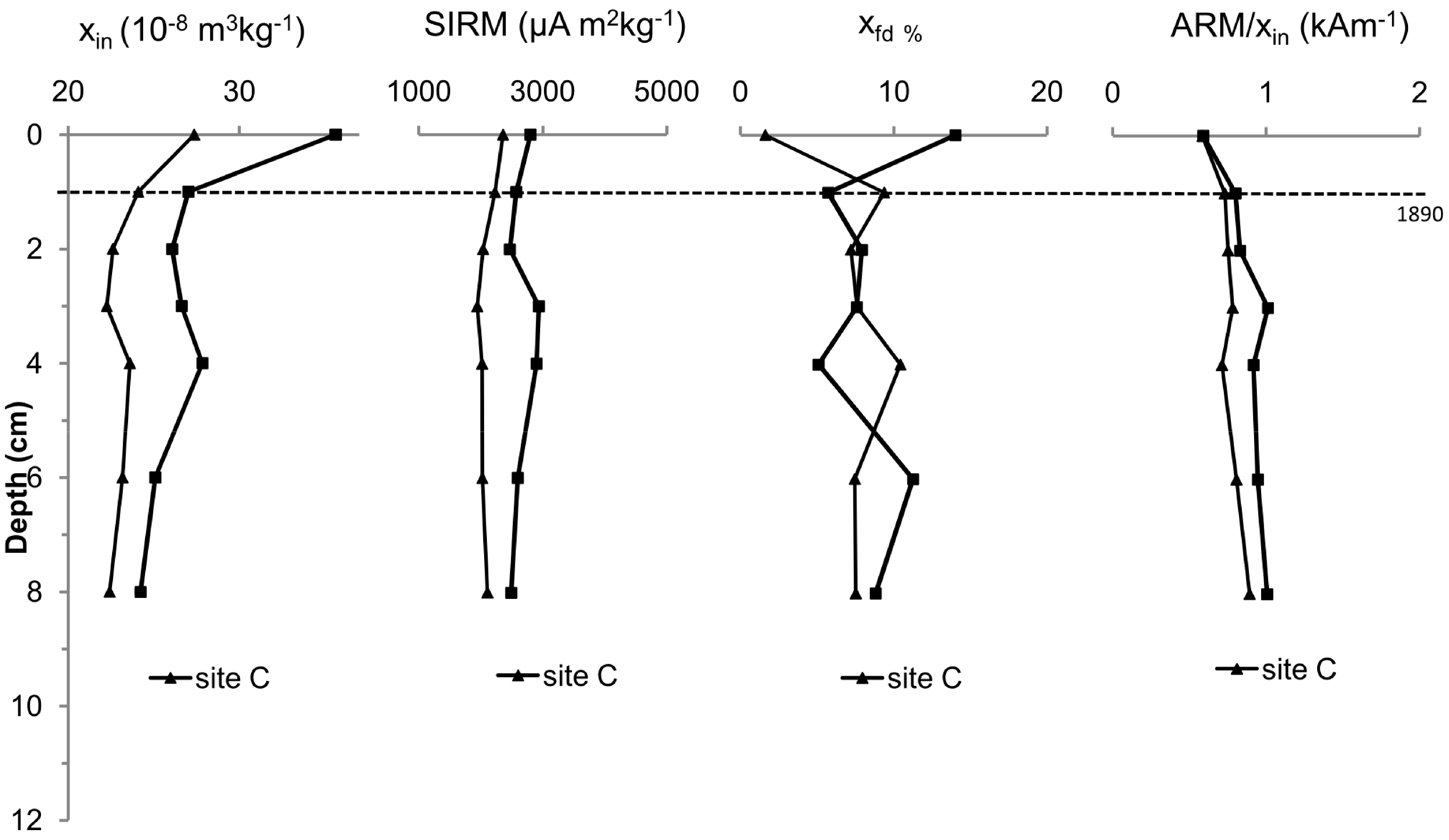
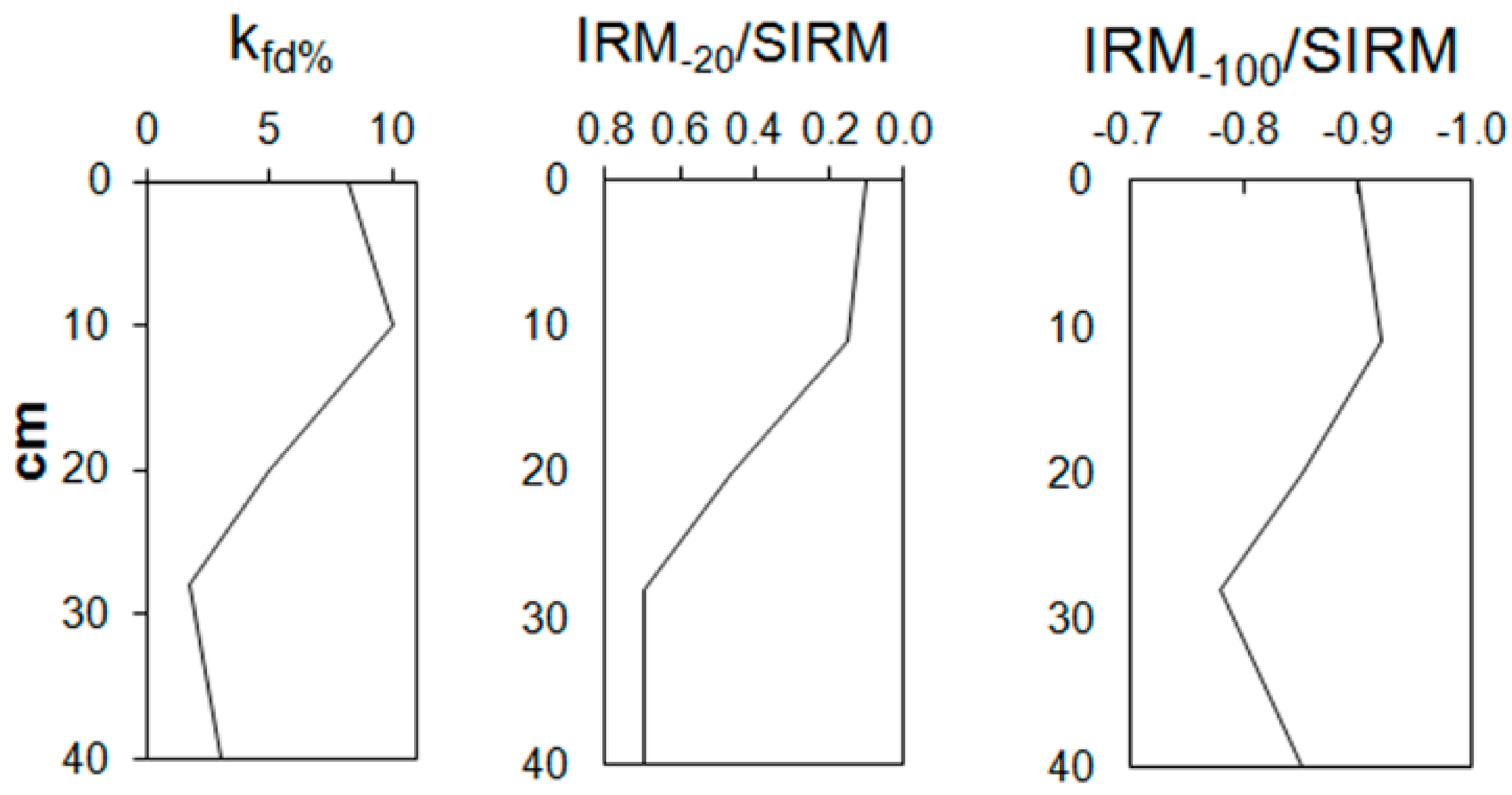
4.1. The Louros and Acheloos Estuaries


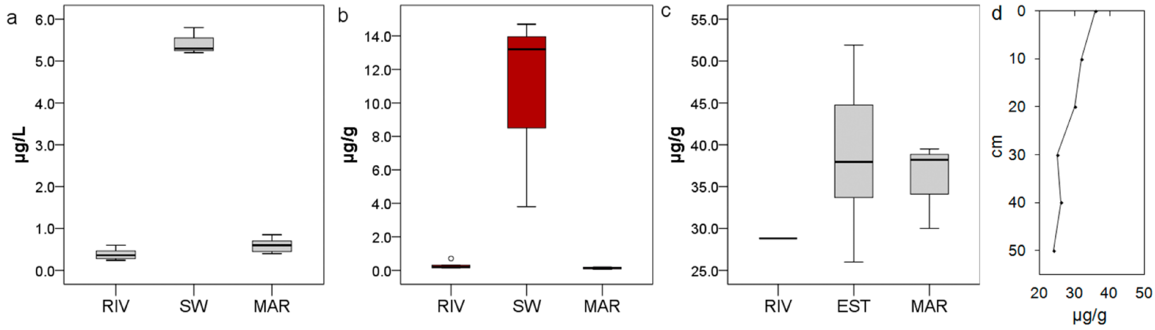
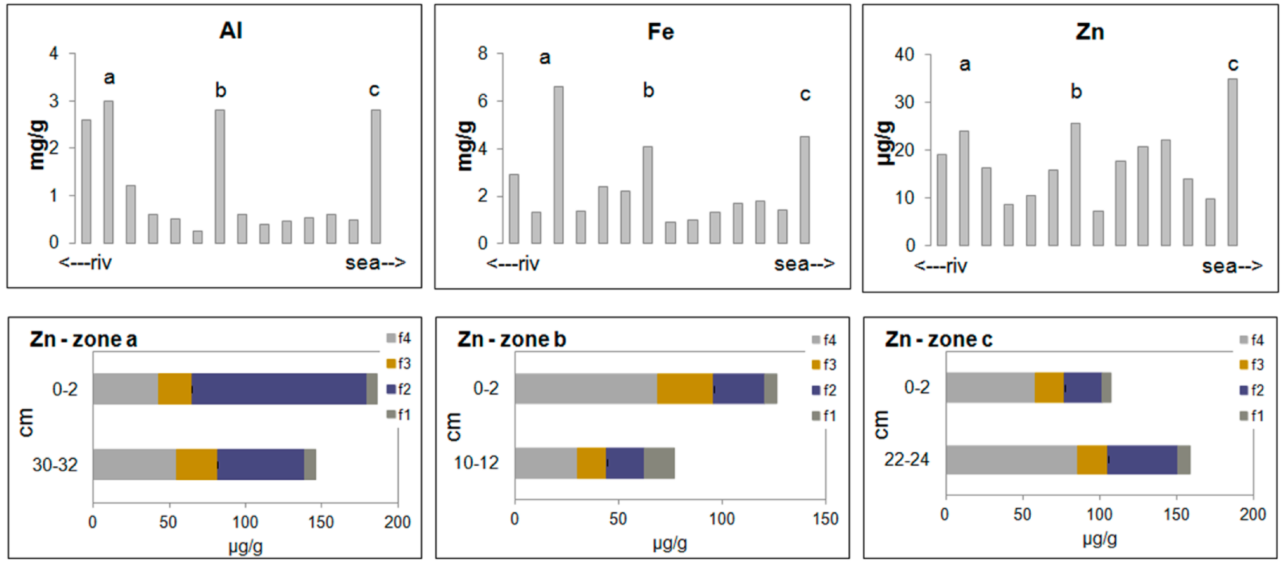
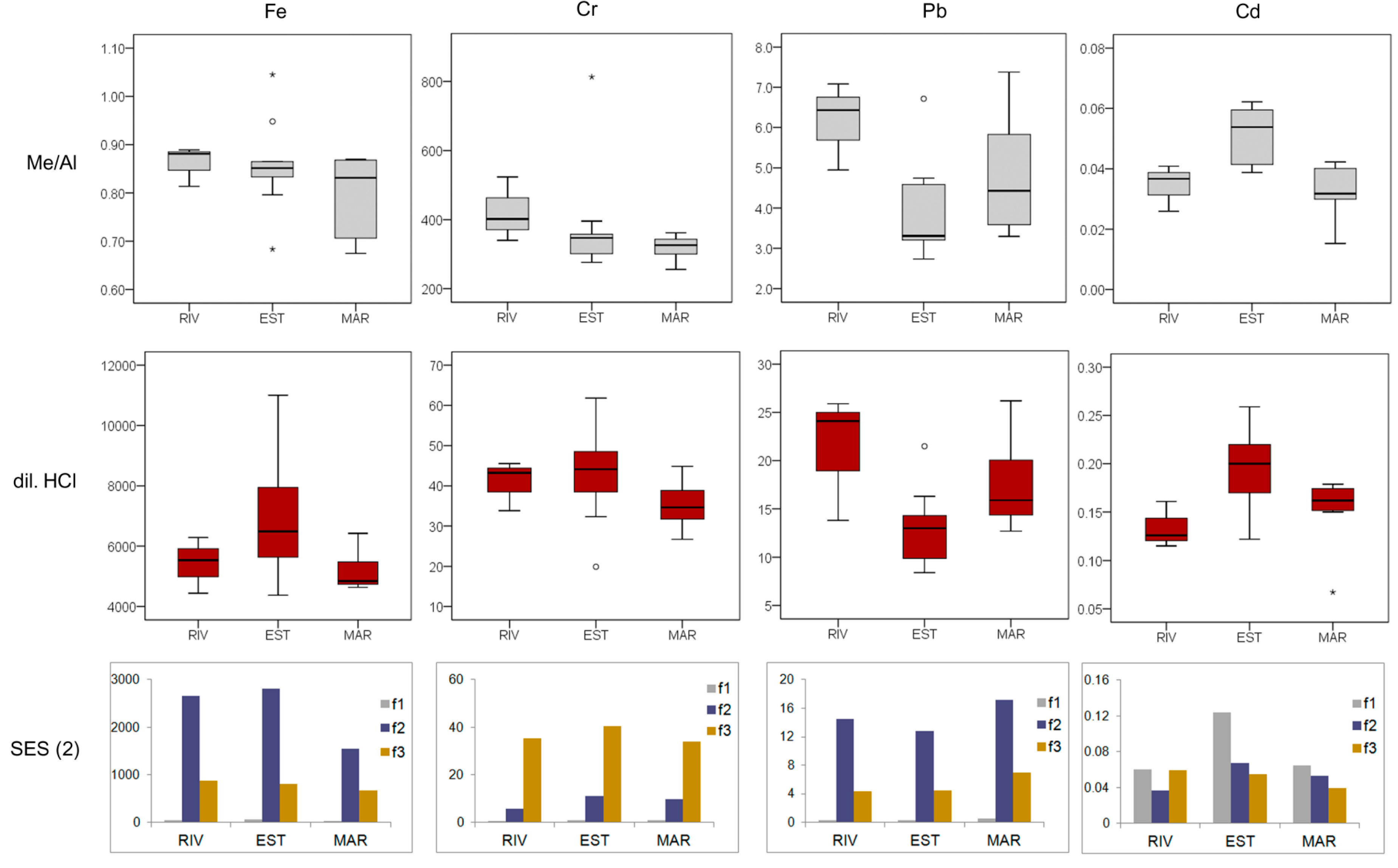
4.2. The Asopos Estuary

| Sector | Statistics data | χin (10−8 m3 kg−1) | χfd% | SIRM (mA m2 kg−1) | HIRM (mA m2 kg−1) | S−100 | SIRM/χin (kA m−1) | HARD (%) | SOFT (%) | Modified L-ratio |
|---|---|---|---|---|---|---|---|---|---|---|
| All data | mean ± sd | 66.4 ± 18.2 | 3.54 ± 1.42 | 12.0 ± 4.5 | 0.21 ± 0.11 | −0.749 ± 0.042 | 17.8 ± 3.7 | 1.77 ± 0.59 | 31.2 ± 6.9 | 0.14 ± 0.05 |
| median | 71.2 | 3.56 | 11.2 | 0.19 | −0.750 | 16.7 | 1.81 | 28.1 | 0.16 | |
| min–max | 32.1–89.4 | 0.82–5.49 | 5.7–24.3 | 0.09–0.44 | −0.810–(−0.680) | 13.1–27.4 | 0.86–2.77 | 24.8–48.0 | 0.07–0.25 | |
| RIV | mean ± sd | 79.2 ± 7.6 | 3.03 ± 1.15 | 12.8 ± 2.3 | 0.12 ± 0.02 | −0.777 ± 0.035 | 16.1 ± 2.2 | 0.90 ± 0.04 | 30.9 ± 2.8 | 0.08 ± 0.01 |
| median | 79.7 | 3.53 | 12.1 | 0.11 | −0.780 | 17.0 | 0.92 | 30.7 | 0.08 | |
| min–max | 71.3–86.5 | 1.71–3.84 | 10.9–15.4 | 0.09–0.14 | −0.810–(−0.740) | 13.7–17.8 | 0.86–0.93 | 28.1–33.8 | 0.07–0.09 | |
| EST | mean ± sd | 59.3 ± 24.3 | 2.97 ± 1.43 | 12.8 ± 7.1 | 0.26 ± 0.15 | −0.735 ± 0.053 | 20.7 ± 4.1 | 2.02 ± 0.6 | 33.5 ± 10.7 | 0.16 ± 0.06 |
| median | 52.3 | 2.93 | 11.0 | 0.21 | −0.720 | 20.6 | 2.1 | 27.4 | 0.16 | |
| min–max | 32.1–89.4 | 0.82–5.45 | 5.73–24.3 | 0.12–0.44 | −0.800–(−0.680) | 16.4–27.4 | 1.11–2.77 | 24.8–48.0 | 0.07–0.25 | |
| MAR | mean ± sd | 69.4 ± 5.0 | 4.58 ± 1.02 | 10.9 ± 1.1 | 0.21 ± 0.02 | −0.750 ± 0.026 | 15.7 ± 1.4 | 1.9 ± 0.2 | 29.0 ± 1.8 | 0.16 ± 0.03 |
| median | 68.6 | 5.06 | 10.8 | 0.22 | −0.760 | 16.1 | 1.9 | 28.4 | 0.16 | |
| min–max | 64.6–76.3 | 2.78–5.49 | 9.7–12.5 | 0.18–0.23 | −0.780–(−0.710) | 13.1–17.1 | 1.6–2.3 | 27.5–32.0 | 0.11–0.19 |
5. Some Management Aspects and Conclusions

Acknowledgments
Author Contributions
Conflicts of Interest
References
- Salomons, W.; Förstner, U. Metals in the Hydrocycle; Springer-Velag: Berlin, Germany, 1984. [Google Scholar]
- Nriagu, J.O.; Pacyna, J.M. Quantitative assessment of worldwide contamination of air, water and soils by trace metals. Nature 1988, 333, 134–139. [Google Scholar] [CrossRef]
- Fairbrother, A.; Wenstel, R.; Sappington, K.; Wood, W. Framework for metals risk assessment. Ecotoxicol. Environ. Saf. 2007, 68, 145–227. [Google Scholar] [CrossRef]
- Cave, R.R.; Ledoux, L.; Turner, K.; Jickells, T.; Andrews, J.E.; Davies, H. The Humber catchment and its coastal area: From UK to European perspectives. Sci. Total Environ. 2003, 314–316, 31–52. [Google Scholar] [CrossRef]
- Chon, H.-S.; Ohandja, D.-G.; Voulvoulis, N. A risk-based approach to prioritise catchments for diffuse metal pollution management. Sci. Total Environ. 2012, 437, 42–52. [Google Scholar] [CrossRef]
- Scoullos, M.; Oldfield, F.; Thompson, R. Magnetic monitoring of marine particulate pollution in the Elefsis Gulf, Greece. Mar. Pollut. Bull. 1979, 10, 287–291. [Google Scholar]
- Berry, A.; Plater, A.J. Rates of tidal sedimentation from records of industrial pollution and environmental magnetism: The Tees Estuary, North-East England. Water Air Soil Pollut. 1998, 106, 463–479. [Google Scholar] [CrossRef]
- Blundell, A.; Hannam, J.A.; Dearing, J.A.; Boyle, J.F. Detecting atmospheric pollution in surface soils using magnetic measurements: A reappraisal using an England and Wales database. Environ. Pollut. 2009, 157, 2878–2890. [Google Scholar] [CrossRef]
- Georgeaud, V.M.; Rochette, P.; Ambrosi, J.P.; Vandamme, D.; Williamson, D. Relationship between heavy metals and magnetic properties in a large polluted catchment: The Etang de Berre (south of France). Phys. Chem. Earth 1997, 22, 211–214. [Google Scholar] [CrossRef]
- Lecoanet, H.; Lévêque, F.; Ambrosi, J.-P. Magnetic properties of salt-marsh soils contaminated by iron industry emissions (southeast France). J. Appl. Geophys. 2001, 48, 67–81. [Google Scholar] [CrossRef]
- Robertson, D.J.; Taylor, K.G.; Hoon, S.R. Geochemical and mineral magnetic characterisation of urban sediment particulates, Manchester, UK. Appl. Geochem. 2003, 18, 269–282. [Google Scholar] [CrossRef]
- Strzyszcz, Z.; Magiera, T.; Heller, F. The influence of industrial immissions on the magnetic susceptibility of soils in upper Silesia. Stud. Geophys. Geod. 1996, 40, 276–286. [Google Scholar] [CrossRef]
- Zhang, C.; Qiao, Q.; Piper, J.D.A.; Huang, B. Assessment of heavy metal pollution from a fe-smelting plant in urban river sediments using environmental magnetic and geochemical methods. Environ. Pollut. 2011, 159, 3057–3070. [Google Scholar] [CrossRef]
- Neal, C.; Leeks, G.J.L.; Millward, G.E.; Harris, J.R.W.; Huthnance, J.M.; Rees, J.G. Land–ocean interaction: Processes, functioning and environmental management from a UK perspective: An introduction. Sci. Total Environ. 2003, 314–316, 3–11. [Google Scholar] [CrossRef]
- Evans, M.; Heller, F. Environmental Magnetism. Principles and Applications of Enviromagnetics; Academic Press: Waltham, MA, USA, 2003. [Google Scholar]
- Liu, Q.; Roberts, A.P.; Larrasoaña, J.C.; Banerjee, S.K.; Guyodo, Y.; Tauxe, L.; Oldfield, F. Environmental magnetism: Principles and applications. Rev. Geophys. 2012, 50. [Google Scholar] [CrossRef]
- Thompson, R.; Oldfield, F. Environmental Magnetism; Allen and Unwin: London, UK, 1986. [Google Scholar]
- Verosub, K.L.; Roberts, A.P. Environmental magnetism: Past, present, and future. J. Geophys. Res. Solid Earth 1995, 100, 2175–2192. [Google Scholar] [CrossRef]
- Petrovský, E.; Kapička, A.; Jordanova, N.; Knab, M.; Hoffmann, V. Low-field magnetic susceptibility: A proxy method of estimating increased pollution of different environmental systems. Environ. Geol. 2000, 39, 312–318. [Google Scholar] [CrossRef]
- Scholger, R. Heavy metal pollution monitoring by magnetic susceptibility measurements applied to sediments of the river Mur (Styria, Austria). Eur. J. Environ. Eng. Geophys. 1998, 3, 25–37. [Google Scholar]
- Horowitz, A.J.; Elrick, K.A. The relation of stream sediment surface area, grain size and composition to trace element chemistry. Appl. Geochem. 1987, 2, 437–451. [Google Scholar] [CrossRef]
- Warren, L.A.; Haack, E.A. Biogeochemical controls on metal behaviour in freshwater environments. Earth Sci. Rev. 2001, 54, 261–320. [Google Scholar] [CrossRef]
- European Environmental Agency (EEA). Environmental Indicators: Typology and Overview; Technical Report No. 25; European Environmental Agency: Copenhagen, Denmark, 1999. [Google Scholar]
- Dassenakis, M.; Scoullos, M.; Gaitis, A. Trace metals transport and behaviour in the Mediterranean estuary of Acheloos River. Mar. Pollut. Bull. 1997, 34, 103–111. [Google Scholar] [CrossRef]
- Scoullos, M.; Dassenakis, M.; Zeri, C. Trace metal behaviour during summer in a stratified Mediterranean system: The Louros Estuary (Greece). Water Air Soil Pollut. 1996, 88, 269–295. [Google Scholar] [CrossRef]
- Mackereth, F.J.H. A short core sampler for subaqueous deposits. Limnol. Oceanogr. 1969, 14, 145–151. [Google Scholar] [CrossRef]
- Agemian, H.; Chau, A.S.Y. Evaluation of extraction techniques for the determination of metals in aquatic sediments. Analyst 1976, 101, 761–767. [Google Scholar] [CrossRef]
- Scoullos, M. Chemical Studies of the Gulf of Elefsis, Greece. Ph.D. Thesis, University of Liverpool, Liverpool, UK, 1979. [Google Scholar]
- Scoullos, M. Zinc in seawater and sediments of the Gulf of Elefsis, Greece. Water Air Soil Pollut. 1981, 16, 187–207. [Google Scholar] [CrossRef]
- Scoullos, M.J. Lead in coastal sediments: The case of the Elefsis Gulf, Greece. Sci. Total Environ. 1986, 49, 199–219. [Google Scholar] [CrossRef]
- Rauret, G.; Lopez-Sanchez, J.F.; Sahuquillo, A.; Rubio, R.; Davidson, C.; Ure, A.; Quevauviller, Ph. Improvement of the BCR three step sequential extraction procedure prior to the certification of new sediment and soil reference materials. J. Environ. Monit. 1999, 1, 57–61. [Google Scholar]
- Botsou, F.; Karageorgis, A.P.; Dassenakis, E.; Scoullos, M. Assessment of heavy metal contamination and mineral magnetic characterization of the Asopos River sediments (Central Greece). Mar. Pollut. Bull. 2011, 62, 547–563. [Google Scholar]
- Kersten, M.; Smedes, F. Normalization procedures for sediment contaminants in spatial and temporal trend monitoring. J. Environ. Monit. 2002, 4, 109–115. [Google Scholar] [CrossRef]
- Dekkers, M.J. Environmental magnetism: An introduction. Geol. Mijnb. 1997, 76, 163–182. [Google Scholar] [CrossRef]
- Robinson, S.G. Early diagenesis in an organic-rich turbidite and pelagic clay sequence from the Cape Verde Abyssal Plain, NE Atlantic: Magnetic and geochemical signals. Sediment. Geol. 2001, 143, 91–123. [Google Scholar]
- Maher, B.A. Characterisation of soils by mineral magnetic measurements. Phys. Earth Planet. Inter. 1986, 42, 76–92. [Google Scholar] [CrossRef]
- Stober, J.C.; Thompson, R. An investigation into the source of magnetic minerals in some Finnish lake sediments. Earth Planet. Sci. Lett. 1979, 45, 464–474. [Google Scholar] [CrossRef]
- Xie, S.; Dearing, J.A.; Bloemendal, J.; Boyle, J.F. Association between the organic matter content and magnetic properties in street dust, Liverpool, UK. Sci. Total Environ. 1999, 241, 205–214. [Google Scholar] [CrossRef]
- Liu, Q.; Roberts, A.P.; Torrent, J.; Horng, C.-S.; Larrasoaña, J.C. What do the HIRM and S-ratio really measure in environmental magnetism? Geochem. Geophys. Geosyst. 2007, 8. [Google Scholar] [CrossRef]
- Hao, Q.; Oldfield, F.; Bloemendal, J.; Guo, Z. The magnetic properties of loess and paleosol samples from the Chinese Loess Plateau spanning the last 22 million years. Palaeogeogr. Palaeoclimatol. Palaeoecol. 2008, 260, 389–404. [Google Scholar] [CrossRef]
- Hao, Q.; Oldfield, F.; Bloemendal, J.; Torrent, J.; Guo, Z. The record of changing hematite and goethite accumulation over the past 22 Myr on the Chinese Loess Plateau from magnetic measurements and diffuse reflectance spectroscopy. J. Geophys. Res. Solid Earth 2009, 114. [Google Scholar] [CrossRef]
- Scoullos, M. Trace metals in a landlocked intermittently anoxic basin. In Trace Metals in Sea Water; Wong, C.S., Bouyle, E., Bruland, K.W., Burton, J.D., Goldberg, E.D., Eds.; Plenum Press: New York, NY, USA, 1983; pp. 351–365. [Google Scholar]
- Scoullos, M.; Riley, J.P. Water circulation in the Gulf of Elefsis, Greece. Thalass. Jugosl. 1978, 14, 357–370. [Google Scholar]
- Scoullos, M.J.; Oldfield, F. Trace metal and magnetic studies of sediments in Greek estuaries and enclosed gulfs. Mar. Chem. 1986, 18, 249–268. [Google Scholar]
- Heller, F.; Strzyszcz, Z.; Magiera, T. Magnetic record of industrial pollution in forest soils of Upper Silesia, Poland. J. Geophys. Res. Solid Earth 1998, 103, 17767–17774. [Google Scholar] [CrossRef]
- Oldfield, F.; Scoullos, M. Particulate pollution monitoring in the Elefsis Gulf: The role of mineral magnetic studies. Mar. Pollut. Bull. 1984, 15, 229–231. [Google Scholar] [CrossRef]
- Dearing, J.A.; Dann, R.J.L.; Hay, K.; Lees, J.A.; Loveland, P.J.; Maher, B.A.; O’Grady, K. Frequency-dependent susceptibility measurements of environmental materials. Geophys. J. Int. 1996, 124, 228–240. [Google Scholar] [CrossRef]
- Mullins, C.E. Magnetic susceptibility of the soil and its significance in soil science—A review. J. Soil Sci. 1977, 28, 223–246. [Google Scholar] [CrossRef]
- Oldfield, F.; Barnosky, C.; Leopold, E.B.; Smith, J.P. Mineral magnetic studies of lake sediments. Hydrobiologia 1983, 103, 37–44. [Google Scholar]
- Oldfield, F.; Maher, B.A.; Donoghue, J.; Pierce, J. Particle size related, mineral magnetic source sediment linkages in the Rhode River catchment, Maryland, USA. J. Geol. Soc. 1985, 142, 1035–1046. [Google Scholar]
- Panagiotoulias, I. Long Term Impact of Iron and Steel Mill Activities on the Marine Environment of the Mediterranean, Based on Measurements in the Gulf of Elefsis. Ph.D. Thesis, University of Athens, Athens, Greece.
- Zhou, Y.; Ning, X.-A.; Liao, X.; Lin, M.; Liu, J.; Wang, J. Characterization and environmental risk assessment of heavy metals found in fly ashes from waste filter bags obtained from a Chinese steel plant. Ecotoxicol. Environ. Saf. 2013, 95, 130–136. [Google Scholar] [CrossRef]
- Oldfield, F.H.A.; Jones, M.D.H.; Chester, R.; Dearing, J.A.; Olsson, L.; Prospero, J.M. Magnetic differentiation of atmospheric dusts. Nature 1985, 317, 516–518. [Google Scholar] [CrossRef]
- Nolting, R.F.; Helder, W. Lead and zinc as indicators for atmospheric and riverine particle transport to sediments in the Gulf of Lions. Oceanol. Acta 1991, 14, 358–367. [Google Scholar]
- Oldfield, F.; Higgit, S.R.; Maher, B.A.; Appleby, P.G.; Scoullos, M. A new integrative methodology for desertification studies based on magnetic and short-lived radioisotope measurements. In Proceedings of the Information Symposium in the EEC Programme on Climatology, Mytilene, Greece, 15–18 April 1984.
- Chester, R.; Sharples, E.J.; Sanders, G.; Oldfield, F. The distribution of natural and non-crustal ferrimagnetic minerals in soil-sized particulates from the Mediterranean atmosphere. Water Air Soil Pollut. 1984, 23, 25–35. [Google Scholar] [CrossRef]
- Zeri, C. Application of the Environmental Magnetic Methodology in Offshore Marine Systems. The Case of NW Mediterranean Sea. Ph.D. Thesis, University of Athens, Athens, Greece, 1995. [Google Scholar]
- Heussner, S.; de Madron, X.D.; Calafat, A.; Canals, M.; Carbonne, J.; Delsaut, N.; Saragoni, G. Spatial and temporal variability of downward particle fluxes on a continental slope: Lessons from an 8-yr experiment in the Gulf of Lions (NW Mediterranean). Mar. Geol. 2006, 234, 63–92. [Google Scholar]
- Palanques, A.; de Madron, X.D.; Puig, P.; Fabres, J.; Guillén, J.; Calafat, A.; Canals, M.; Heussner, S.; Bonnin, J. Suspended sediment fluxes and transport processes in the Gulf of Lions submarine canyons. The role of storms and dense water cascading. Mar. Geol. 2006, 234, 43–61. [Google Scholar]
- Canals, M.; Puig, P.; de Madron, X.D.; Heussner, S.; Palanques, A.; Fabres, J. Flushing submarine canyons. Nature 2006, 444, 354–357. [Google Scholar] [CrossRef]
- Zuo, Z.; Eisma, D.; Gieles, R.; Beks, J. Accumulation rates and sediment deposition in the Northwestern Mediterranean. Deep Sea Res. Part II Top. Stud. Oceanogr. 1997, 44, 597–609. [Google Scholar] [CrossRef]
- Martin, J.-M.; Elbaz-Poulichet, F.; Guieu, C.; Loÿe-Pilot, M.-D.; Han, G. River versus atmospheric input of material to the Mediterranean Sea: An overview. Mar. Chem. 1989, 28, 159–182. [Google Scholar] [CrossRef]
- Lipiatou, E.; Saliot, A. Fluxes and transport of anthropogenic and natural polycyclic aromatic hydrocarbons in the western Mediterranean Sea. Mar. Chem. 1991, 32, 51–71. [Google Scholar] [CrossRef]
- Tolosa, I.; Bayona, J.M.; Albaigés, J. Aliphatic and polycyclic aromatic hydrocarbons and sulfur/oxygen derivatives in northwestern Mediterranean sediments: Spatial and temporal variability, fluxes, and budgets. Environ. Sci. Technol. 1996, 30, 2495–2503. [Google Scholar] [CrossRef]
- Remoudaki, E.; Bergametti, G.; Buat-Ménard, P. Temporal variability of atmospheric lead concentrations and fluxes over the northwestern Mediterranean Sea. J. Geophys. Res. Atmos. 1991, 96, 1043–1055. [Google Scholar]
- Loÿe-Pilot, M.D.; Martin, J.M. Saharan dust input to the western Mediterranean: An eleven years record in Corsica. In The Impact of Desert Dust across the Mediterranean; Guerzoni, S., Chester, R., Eds.; Springer: Berlin, Germany, 1996; Volume 11, pp. 191–199. [Google Scholar]
- Scoullos, M.; Zeri, C. The use of mineral magnetic measurements for the study of transport and sedimentation of particles in the Gulf of Lions (N.W. Mediterranean). Oceanol. Acta 1993, 16, 53–61. [Google Scholar]
- Skoulikidis, N. Hydrochemical character and spatiotemporal variations in a heavily modified river of western Greece. Environ. Geol. 2003, 43, 814–824. [Google Scholar]
- Skoulikidis, N.T. The environmental state of rivers in the Balkans—A review within the DPSIR framework. Sci. Total Environ. 2009, 407, 2501–2516. [Google Scholar] [CrossRef]
- Scoullos, M.; Dassenakis, M.; Gaitis, A. Distribution of nutrients in the Acheloos River mouth, Greece. Rapp. Comm. Int. Mer. Med. 1992, 33, 182. [Google Scholar]
- Dassenakis, M.; Degaita, A.; Scoullos, M. Trace metals in sediments of a Mediterranean estuary affected by human activities (Acheloos river estuary, Greece). Sci. Total Environ. 1995, 168, 19–31. [Google Scholar] [CrossRef]
- Guieu, C.; Martin, J.M. The level and fate of metals in the Danube River Plume. Estuar. Coast. Shelf Sci. 2002, 54, 501–512. [Google Scholar]
- Rondeau, B.; Cossa, D.; Gagnon, P.; Pham, T.T.; Surette, C. Hydrological and biogeochemical dynamics of the minor and trace elements in the St. Lawrence River. Appl. Geochem. 2005, 20, 1391–1408. [Google Scholar]
- Zhou, J.L.; Liu, Y.P.; Abrahams, P.W. Trace metal behaviour in the Conwy estuary, North Wales. Chemosphere 2003, 51, 429–440. [Google Scholar] [CrossRef]
- Zwolsman, J.J.G.; van Eck, B.T.M.; van der Weijden, C.H. Geochemistry of dissolved trace metals (cadmium, copper, zinc) in the Scheldt Estuary, Southwestern Netherlands: Impact of seasonal variability. Geochim. Cosmochim. Acta 1997, 61, 1635–1652. [Google Scholar] [CrossRef]
- Maher, B.A. Magnetic properties of modern soils and Quaternary loessic paleosols: Paleoclimatic implications. Palaeogeogr. Palaeoclimatol. Palaeoecol. 1998, 137, 25–54. [Google Scholar] [CrossRef]
- Maher, B.A.; Hallam, D.F. Magnetic carriers and remanence mechanisms in magnetite-poor sediments of Pleistocene age, southern North Sea margin. J. Quat. Sci. 2005, 20, 79–94. [Google Scholar] [CrossRef]
- Lepland, A.; Stevens, R.L. Mineral magnetic and textural interpretations of sedimentation in the Skagerrak, Eastern North Sea. Mar. Geol. 1996, 135, 51–64. [Google Scholar] [CrossRef]
- Oldfield, F.; Asioli, A.; Accorsi, C.A.; Mercuri, A.M.; Juggins, S.; Langone, L.; Rolph, T.; Trincardi, F.; Wolff, G.; Gibbs, Z.; et al. A high resolution late Holocene palaeo environmental record from the central Adriatic Sea. Quat. Sci. Rev. 2003, 22, 319–342. [Google Scholar]
- Botsou, F. Study on the Impact of Ephemeral Rivers to the Coastal Marine Environment: The Case of the Asopos River, Central Greece. Ph.D. Thesis, University of Athens, Athens, Greece, 2007. [Google Scholar]
© 2014 by the authors; licensee MDPI, Basel, Switzerland. This article is an open access article distributed under the terms and conditions of the Creative Commons Attribution license (http://creativecommons.org/licenses/by/3.0/).
Share and Cite
Scoullos, M.; Botsou, F.; Zeri, C. Linking Environmental Magnetism to Geochemical Studies and Management of Trace Metals. Examples from Fluvial, Estuarine and Marine Systems. Minerals 2014, 4, 716-745. https://doi.org/10.3390/min4030716
Scoullos M, Botsou F, Zeri C. Linking Environmental Magnetism to Geochemical Studies and Management of Trace Metals. Examples from Fluvial, Estuarine and Marine Systems. Minerals. 2014; 4(3):716-745. https://doi.org/10.3390/min4030716
Chicago/Turabian StyleScoullos, Michael, Fotini Botsou, and Christina Zeri. 2014. "Linking Environmental Magnetism to Geochemical Studies and Management of Trace Metals. Examples from Fluvial, Estuarine and Marine Systems" Minerals 4, no. 3: 716-745. https://doi.org/10.3390/min4030716