Chinese Climate and Vernacular Dwellings

NPS Group, Earle House, Colonial Street, Kingston upon Hull, HU2 8JY, UK
Buildings 2013, 3(1), 143-172; https://doi.org/10.3390/buildings3010143
Submission received: 28 November 2012
/
Revised: 11 January 2013
/
Accepted: 17 January 2013
/
Published: 31 January 2013
(This article belongs to the Special Issue Sustainable Design and Construction)
Abstract
:The industrial and economic expansion of China, particularly its rapid urbanization, has resulted in dramatic increased consumption of energy resources and the resulting environmental impacts at local, regional and global levels. Although a national program aimed at the technological development of sustainable buildings with energy saving potential is ongoing, it is also appropriate to consult vernacular architectural tradition. This holds the potential to learn and adapt important cultural ideas developed over time on the art of balancing thermal comfort between climate and limited resources. This paper explores the five different climatic regions into which China is partitioned by the Chinese authorities: severe cold region, cold region, moderate region, hot summer and cold winter region, and hot summer and mild winter region. Analysis of each region covers the climate and its vernacular architecture with a special focus on how sustainability was addressed. Finally, regional climate scenario has been analyzed on the basis of data from Meteonorm V6.1 with special attention paid to passive design strategies.
1. Introduction
This paper investigates the Chinese climate and the vernacular dwellings with the purpose of adopting the traditional climate-responsive experience into current residential development. China, a country that has developed into the world’s fastest growing economy since the political and economic reforms of 1978, has unique features within its residential sector with regards to building energy demand: a soaring construction speed desperately to couple with the fast growing domestic living standards. However, on the energy supply side, energy relies completely upon the large and inefficient use of coal. As the nation’s economic growth continues, an energy crisis is already apparent and environmental problems continue to surface. Thus, the great challenge for this continuously developing economy is to balance its rapid residential building programs, with the means to protect its environment and conserve energy, through the introduction of long-term energy-efficient strategies that have a sustainable ethos.
China’s topography extends from a subarctic climate to a tropical climate, where the vernacular dwelling forms are numerous and reflect the regional and local climate with surprising efficiency. These climate-responsive building forms, materials and techniques were used for centuries to achieve comfort and they influenced the local inhabitants to adopt environmentally friendly life-styles, and to behave more adaptively.
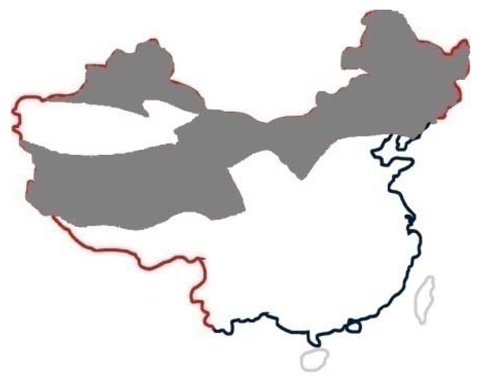
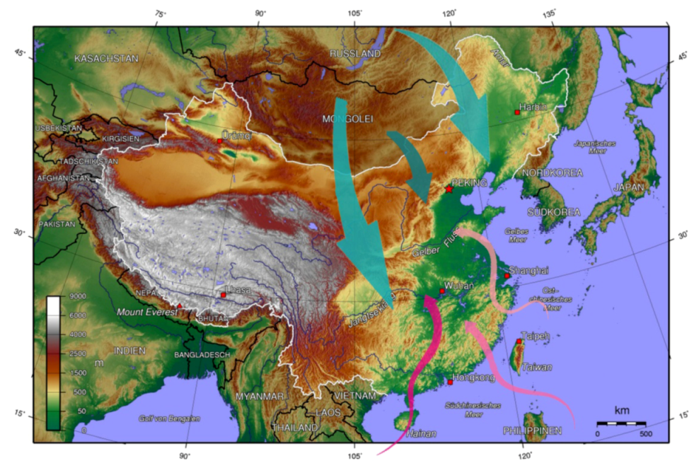
The varied topographies consist of mostly mountains, high plateaus and deserts in the west of the country and deltas, hills, plains and coastlines in the east. The climatic make-up of this land from north (53° N) to south (18° N) is extremely diverse; in short China enjoys a marked continental monsoonal climate characterized by great variety [1]. There are two main air currents that significantly affect the country’s climate (Figure 1): from September to April the following year, the dry and cold winter monsoons from Siberia and Mongolia in the north, gradually become weak as they reach the southern part of the country, resulting in cold and dry winters and great differences in temperature; whilst the warm and moist summer monsoons (May to October) from the oceans bring abundant rainfall and high temperatures, blowing onto the Chinese mainland from south to the midland with little temperature difference [2]. Thus the northeast experiences occasional warm and dry summers and bitterly cold winters; the north and central region has almost continual rainfall, hot summers and cold winters; and the southeast region has substantial rainfall, with semi-tropical summers and mild winters.
Figure 1.
After China topography map [3].
Figure 1.
After China topography map [3].

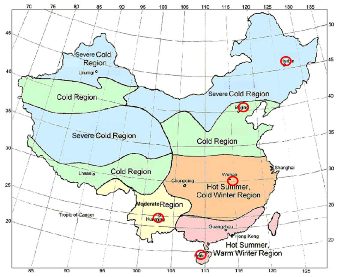
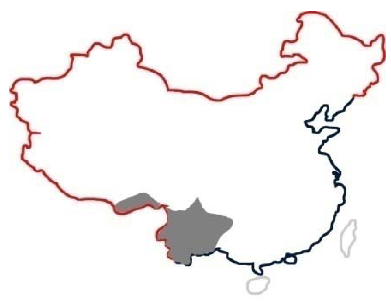
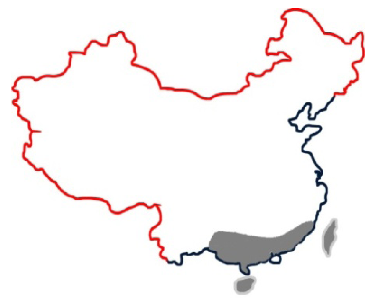
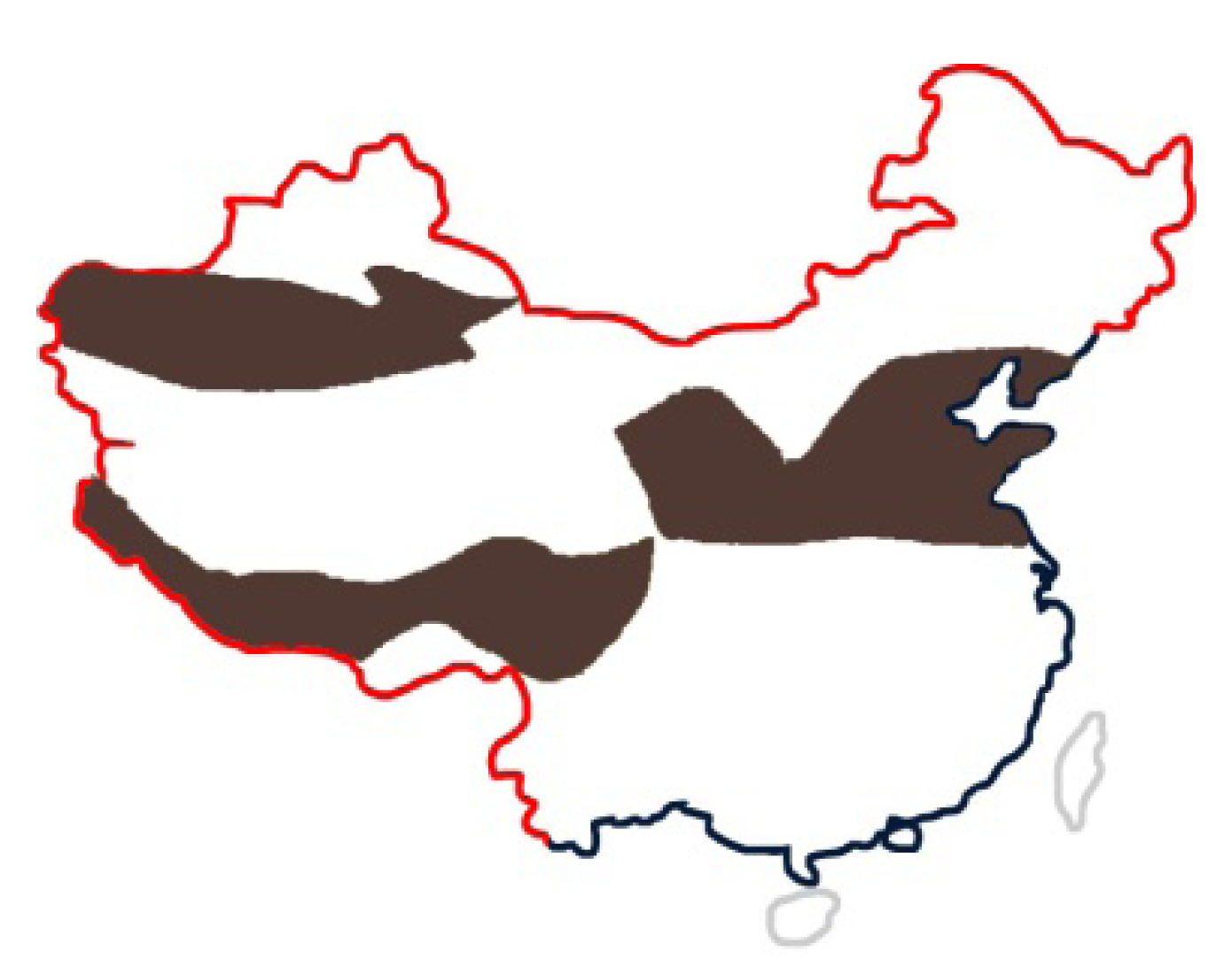
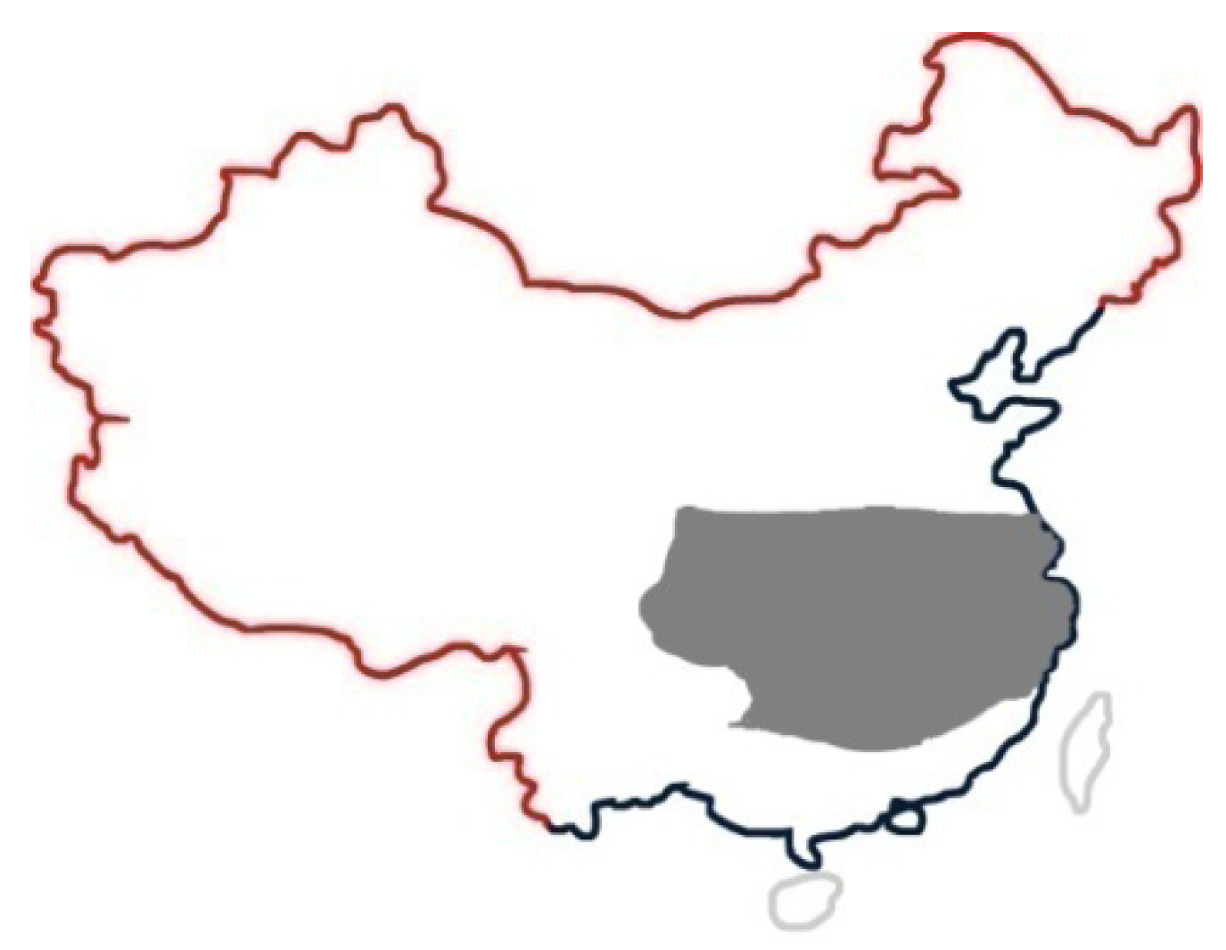
There are five climatic regions partitioned by the Ministry of Construction P.R. China, and five cities have been chosen to exemplify each climate zone: Harbin for the severe cold region; Beijing for the cold region; Wuhan for a hot summer and cold winter region; Kunming for moderate region and Haikou for a hot summer and mild winter region (Figure 2 circled in red). The thermal comfort criteria considered in this paper is 16–29 °C as referenced by the national building regulation (Design Code for Residential Buildings GB50096-1999).
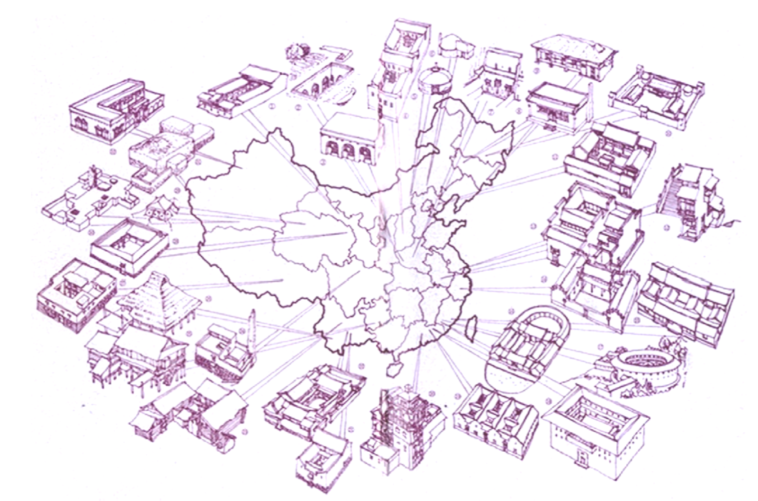
Over the course of thousands of years of civilization, China has developed a rich variety of settlements and vernacular dwellings (Figure 3). These residential houses can generally be divided into three types: courtyard, caved and wooden storied [4]. They have always taken full advantage of natural ecological resources and at the same time paid careful attention to save the resources, and moreover, they possess distinct characteristics of sustainability, which will be explained in detail in the following text.
Figure 2.
After climate map (Specification for thermal design of civil building GB 50176–93).

Figure 3.
Vernacular architecture map [5].
Figure 3.
Vernacular architecture map [5].

2. Severe Cold Region
The severe cold region (Figure 4) covers nearly one third of the entire territory of China, including all the northern and partially central areas. The north of China has a very cold climate because of the high latitude (40° N–53° N), and some land areas in the west have also been defined as having a severe cold climate due to the Qinghai—Tibetan plateau.
Figure 4.
Severe cold region map.
These land areas of China remain at a relatively low level with regards to their social and economic development. This is especially the case in the west of China where there are few inhabitants due to the harsh environment. There are only four large cities formed in this region, whilst the others are either medium-sized or small cities. The city of Harbin has been chosen as the representative location for this climate. Harbin is the capital of Heilongjiang province, which is located 125°42’–130°10’ E, 44°04’–46°40’ N. It is a thriving industrial city and it is also the political, economic, scientific, cultural and communicational center for the north of China. The urban area is 7,086 km2, and has a population of 4.6 million [6].
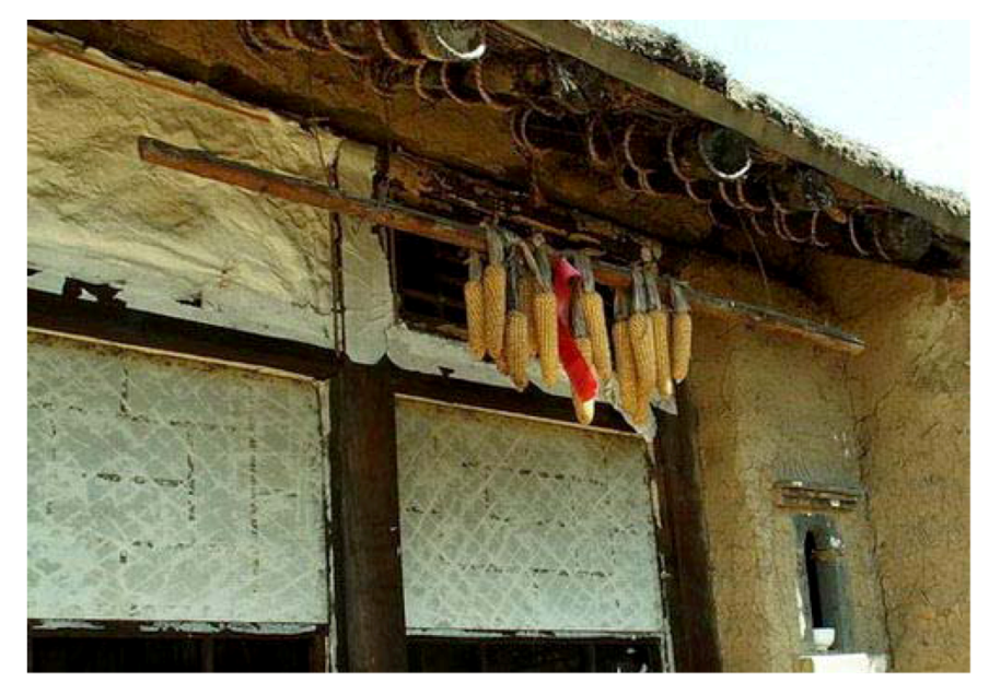
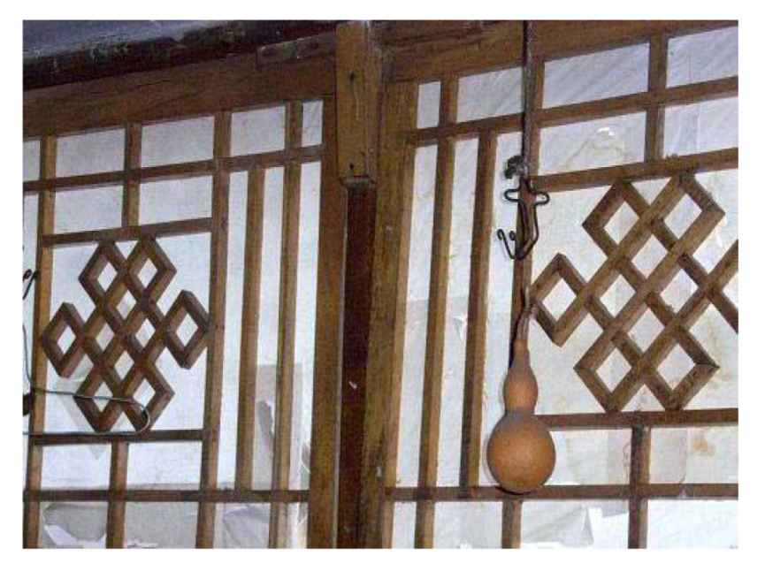
Since 900 CE, when the first Chinese settlers inhabited this area, the people have been struggling against the severe cold climatic conditions. Over time, they constructed quadrangular brick courtyards and used special techniques in order to combat the cold climate [7]: their usual method of construction was to build south facing low-rise houses, with spacious courtyards to obtain sufficient solar access throughout the structure; and the houses were commonly insulated by using 500 mm thick mud walls and two layer of windows. Before the introduction of glass, windows were made from a combination of small wooden partitions with rice pulp stuck from the outside and then treated with oil (Figure 5, Figure 6). The reason for attaching the pulp from the outside was firstly to harness the wooden partition to withstand windy conditions, and another reason was to protect the partition from snow accumulation [6].
Figure 5.
Indoor image of a rice pulp window [8].
Figure 5.
Indoor image of a rice pulp window [8].

Figure 6.
Outside image of a rice pulp window [8].
Figure 6.
Outside image of a rice pulp window [8].
Today, this special technique has been copied in order to seal the joining of the window frame. It was the usual practice before winter began for people to boil local produced glutinous rice in water until it became a thick liquid, then they used the liquid to stick several layers of paper onto the frame joining and window edges. This “rice paper seal” would last for the whole duration of the winter. When the next spring arrived the paper would be torn off and then cleaned with water [9].
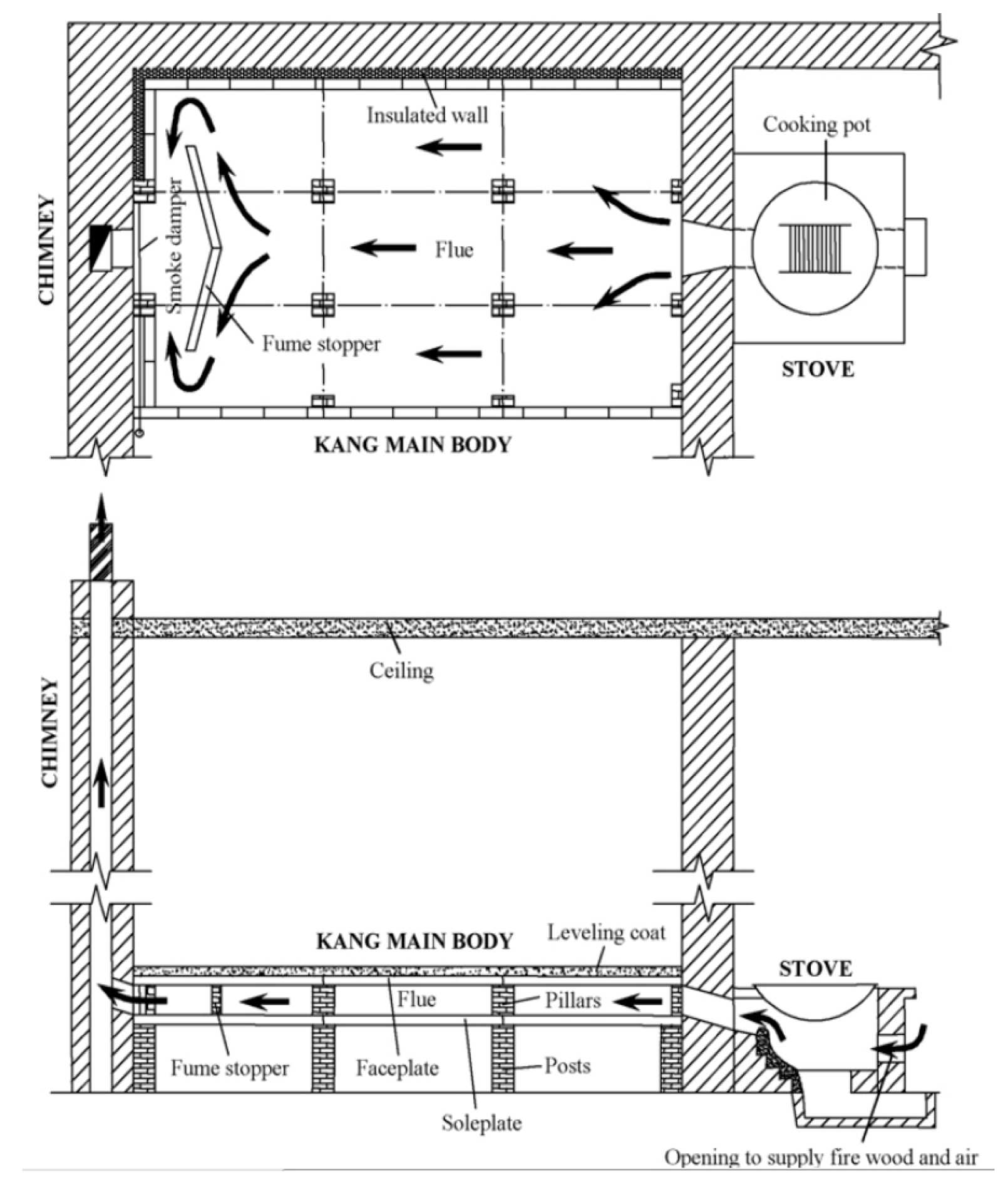
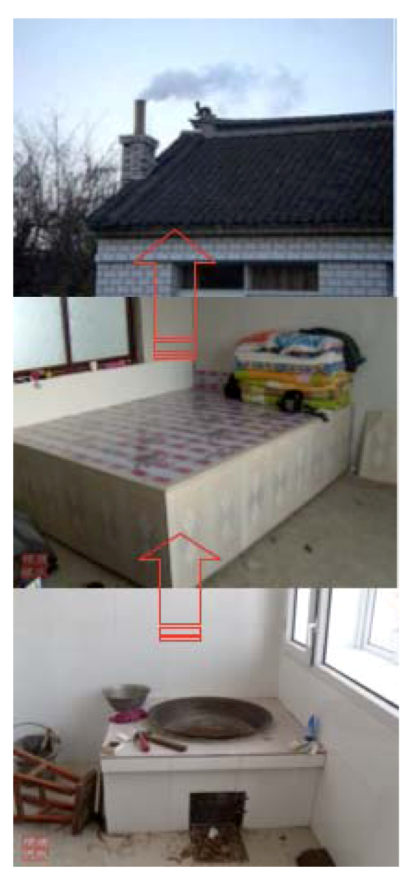
Another unique feature is the “Kang” arrangement, which has been used for heating homes in Northern China for more than 2500 years [10]. A kang system consists of a stove, a kang (bed), channels and a chimney. It utilizes the residual heat of smoke from an adjacent cooking stove, which burns biomaterials and uses the bed to release heat to the bedroom and finally the smoke is exhaled via the chimney. It allows four different home functions of cooking, sleeping, domestic heating and ventilation. The ventilation is integrated into one system and moreover, it harnesses biomass burning for both cooking and space heating and thus reduces the use of commercial energy. It is the accumulated experience from craftsmen that has been handed down from one generation to another that developed this method, and according to the Ministry of Agriculture, there are approximately over 67 million kangs used by 175 million people today in China still [11]. Figure 7, Figure 8 are the flow chart and images for living arrangements centered around the kang.
Figure 7.
Plan and section of kang system [11].
Figure 7.
Plan and section of kang system [11].
Figure 8.
Stove, bed and chimney [11].
Figure 8.
Stove, bed and chimney [11].

This vernacular dwelling type demonstrates how ancestors managed to survive in this climate both naturally and successfully. All the techniques used have addressed the following issues: sufficient solar access, a heavily insulated and airtight building envelope, and the use of biomass for space heating. They have mainly focused on passive heating rather than cooling, which also indicates a cold environment.
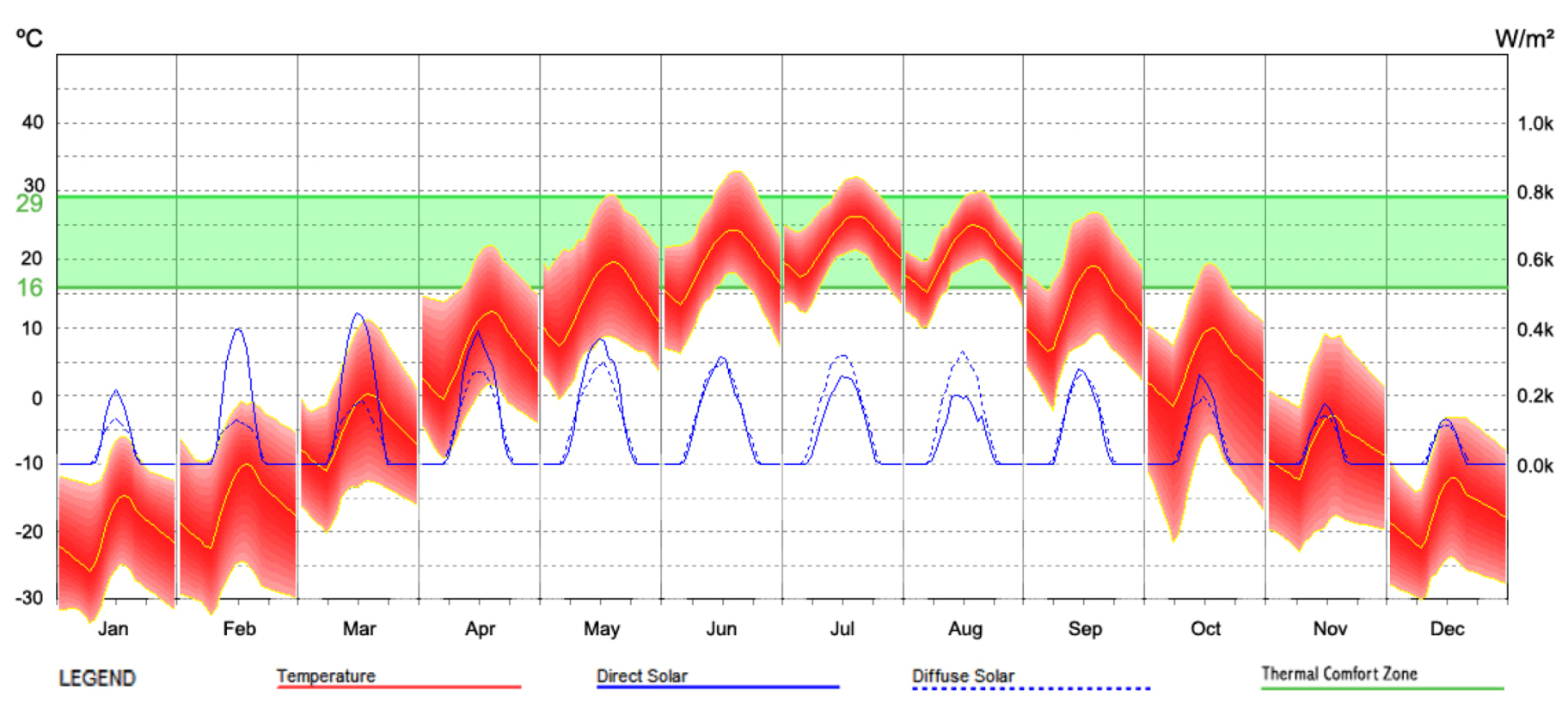
Indeed, this is a cold climate and the Chinese assigned it as a “severe cold region” for a good reason. The representative city—Harbin is located in the subarctic climate zone. Geographically, it is located in north-east China under the direct influence of the cold winter winds from Siberia. It has a distinct four seasons, with a long period of cold arid winter and a short summer as well as the transition period of spring and autumn. Figure 9 displays the climatic data for Harbin.
Figure 9, Table 1 indicates a cold winter dominated climate profile, where average monthly temperatures are below the comfort range most time of the year. It can be seen that from November to March, the average monthly temperature drops below freezing point, whilst the moderate climatic months are July and August with an average temperature of just above 20 °C. The diurnal temperature range is of 10 °C and the monthly horizontal solar radiation fluctuates from 50–160 kWh/m² accordingly. Adequate precipitation occurs during the moderate weather months, whilst heavy snow usually happens from November to March. On average there are 105 snow days with an annual average fall of 41 mm. The prevailing winds are from the west and the north and can be a strong breeze or even strong gales during wintertime. In response to the climate the building should firstly harness as much solar gain as possible through the whole year, and then protect it by heavy thermal insulation and airtight building envelope so as to reduce the heat loss to the cold outdoor environment. Additional protection against snow and winds should also be considered in the design.
Figure 9.
Harbin climate data, (MeteonormV6.1 date period: 1996–2005).

| Month | Ta | Ta dmax | Ta dmin | RH | H_Gh | H_Bn | SDm | SDd | SDastr | RR | RD | FF | DD |
|---|---|---|---|---|---|---|---|---|---|---|---|---|---|
| Jan | –17.1 | –11.9 | –21.2 | 71 | 52 | 93 | 177 | 5.7 | 8.9 | 7 | 0 | 2.4 | 11 |
| Feb | –11.3 | –5.7 | –16.7 | 64 | 74 | 109 | 191 | 6.8 | 10.2 | 3 | 1 | 2.7 | 11 |
| Mar | –2.2 | 3.2 | –7.2 | 50 | 119 | 141 | 234 | 7.5 | 11.7 | 10 | 1 | 3.3 | 11 |
| Apr | 8.5 | 14.2 | 3.1 | 43 | 140 | 116 | 221 | 7.4 | 13.4 | 10 | 3 | 3.4 | 184 |
| May | 15.8 | 21.6 | 9.8 | 45 | 163 | 118 | 254 | 8.2 | 14.7 | 32 | 4 | 3.3 | 153 |
| Jun | 21.6 | 26.4 | 15.3 | 53 | 168 | 124 | 249 | 8.3 | 15.5 | 44 | 7 | 2.9 | 174 |
| Jul | 23.7 | 27.9 | 19.3 | 71 | 156 | 113 | 238 | 7.7 | 15.2 | 50 | 11 | 2.6 | 153 |
| Aug | 21.4 | 25.7 | 17.1 | 73 | 139 | 114 | 231 | 7.5 | 14 | 60 | 8 | 2.3 | 174 |
| Sep | 15.6 | 21 | 9.8 | 62 | 119 | 116 | 225 | 7.5 | 12.4 | 30 | 6 | 2.4 | 11 |
| Oct | 6.3 | 11.8 | 1.7 | 55 | 88 | 111 | 211 | 6.8 | 10.8 | 18 | 3 | 2.8 | 11 |
| Nov | –5.1 | –0.4 | –9.1 | 61 | 56 | 93 | 176 | 5.9 | 9.3 | 7 | 1 | 2.7 | 11 |
| Dec | –14.5 | –9.5 | –18.8 | 68 | 43 | 74 | 155 | 5 | 8.5 | 4 | 1 | 2.5 | 11 |
| Year | 5.2 | - | - | 60 | 1315 | 1321 | 2562 | 7.3 | - | 275 | 46 | 2.8 | 55 |
Ta: air temperature (°C); Ta dmax: mean daily minimum Ta; Ta dmin: mean daily minimum Ta; RH: relative humidity; H_Gh: irradiation of global radiation horizontal; H_Bn: irradiation of beam (kWh/m2); SDm: sunshine duration monthly; SDd: sunshine duration daily (hours); SDastr: sunshine duration astronomic; RR: precipitation (mm); RD: days with precipitation; FF: wind speed (m/s); DD: wind direction (°C).
3. Cold Region
Another third of China lies within a cold region, which includes the central northeast, part of the northwest and the entire southwest (Figure 10). Generally, it is a mixed topography of basin, plateau and plain that is located in a cold temperate belt and heavily influenced by the monsoon, the Siberian anticyclone and the Highland areas.
Figure 10.
Cold region map.
Throughout this vast land, vernacular architectures can be seen abundantly and they represent a rational answer to the local climates. These structures also provide reasonable comfort and indoor air quality without having the benefit of modern day air-conditioning systems. Figure 11, Figure 12, Figure 13, Figure 14 show a unique cave dwelling that appears in northwest China, where the climate is cold and dry and the soil is firm.
This typical local residential form can be dated back to the Neolithic age, when people excavated the soil from hillsides, and made caves available for them to live in [12]. This form of dwelling has been handed down through the generations, but the idea remains the same. Because of the capacity of the heavy mass, the cave is cooler during the summer and warmer in the winter, which is an ideal solution for achieving thermal comfort. Moreover, it was cheap, available and balances the local environment with local inhabitants. Furthermore, the kang system has been used in the cave-dwelling too, as displayed in the section in Figure 13. Although it is not practical to house a population of 1.3 billion in caves, cave–dwelling demonstrates local people’s understanding of the environment in which they live and their ability to adapt current resources and put them to practical use.
Figure 11.
Cave-dwelling plan.

Figure 12.
Cave-dwelling elevation and section.

Figure 13.
Cave-dwelling [13].
Figure 13.
Cave-dwelling [13].
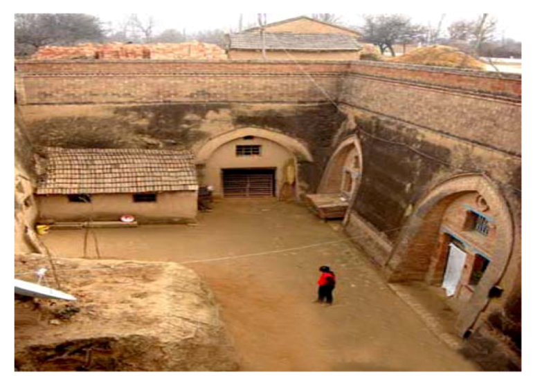
Figure 14.
Indoor image [14].
Figure 14.
Indoor image [14].
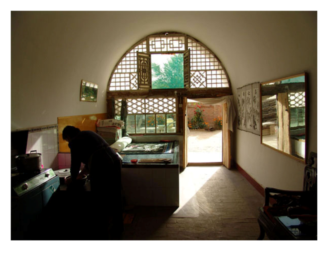
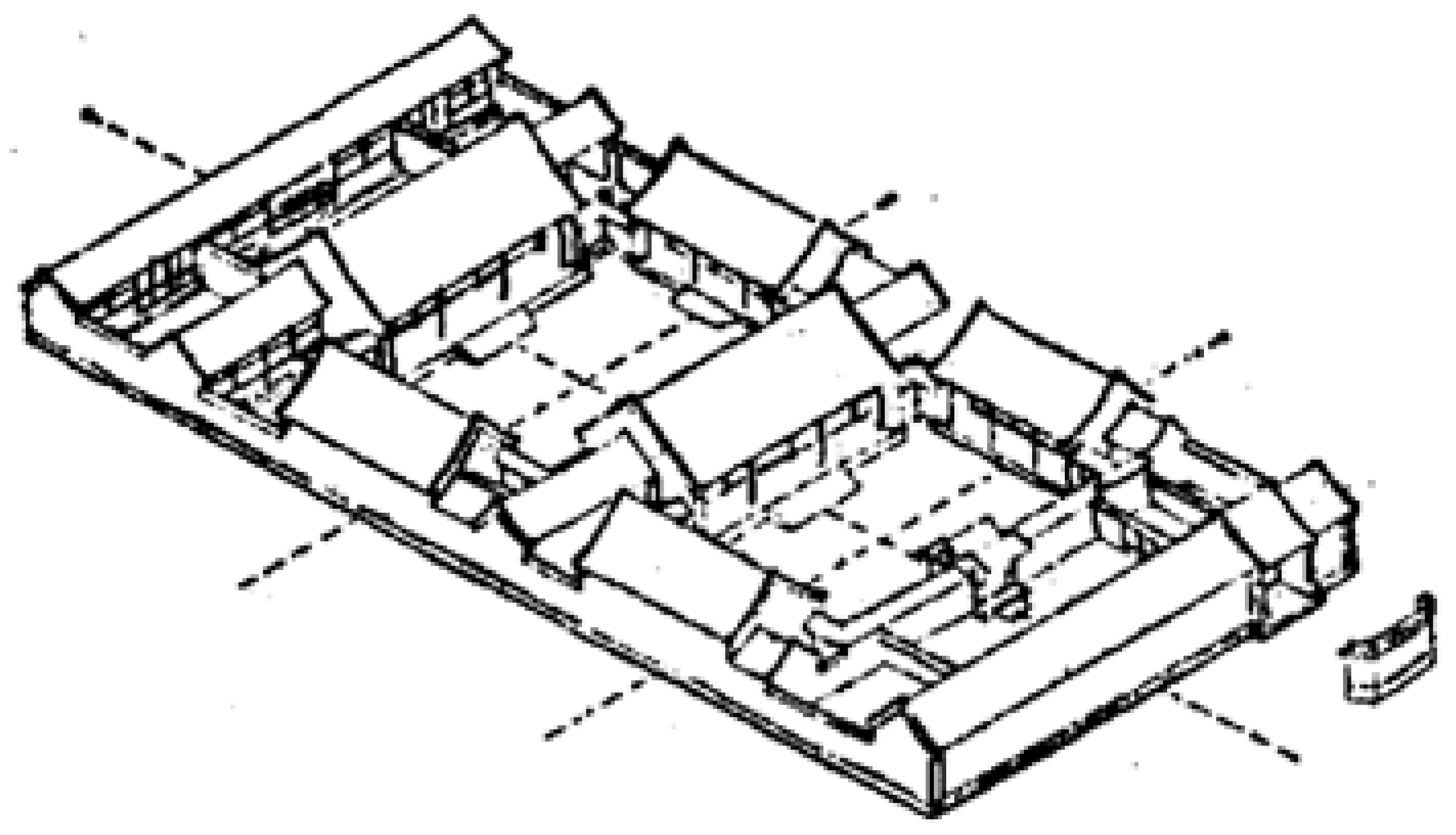
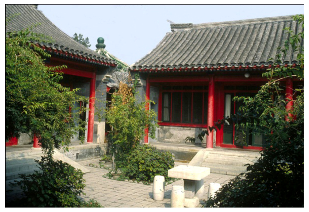
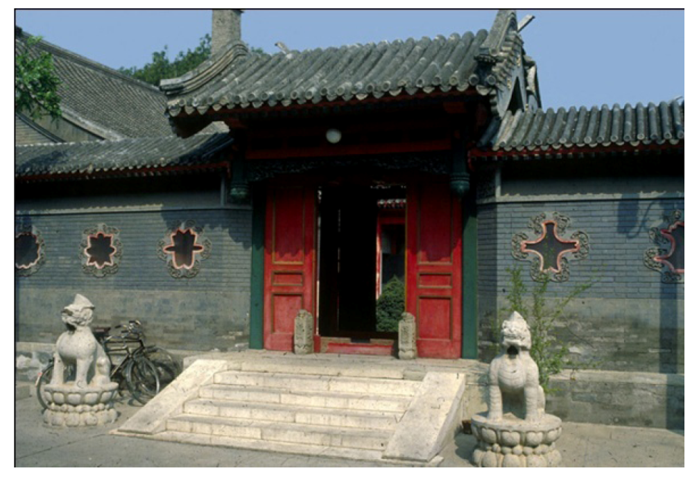
“Siheyuan” (Figure 15, Figure 16) is another typical traditional architectural style in China, which consists of a square housing compound with rooms enclosing a central courtyard. This courtyard often contains a pomegranate or other type of tree, as well as potted flowers or a fish tank (Figure 17).
Figure 15.
Siheyuan plan and section [15].
Figure 15.
Siheyuan plan and section [15].
Siheyuans usually form alleys, which link together the interior of a city. Since alleys are usually straight and run east-to-west, houses can face north and south. As in the severe cold region, the houses are low-rise, but some of them have first floors. The central courtyard is usually big enough to allow ample solar access, and provides wind protection during the winter. Efficient insulation has also been used for houses as there are commonly 370 mm thick brick walls and single glazing with sealed window frames made of rice paper. They also have kang systems similar to those used in the severe cold region. The Siheyuan’s summer is pleasant too, the openings on the walls allow airflow to cross, whilst the verandas, overhanging roofs and trees create sufficient shading and semi-open space for afternoon tea and evening gatherings (Figure 17, Figure 18).
Figure 16.
Siheyuan Perspective [15].
Figure 16.
Siheyuan Perspective [15].

Figure 17.
Siheyuan patio, showing vrandahs [8].
Figure 17.
Siheyuan patio, showing vrandahs [8].

Figure 18.
Siheyuan entrance, showing windows on wall [8].
Figure 18.
Siheyuan entrance, showing windows on wall [8].

Cave-dwellings and siheyuan both successfully combine Chinese architectural techniques and human comfort. Their climate-responsives have focused on energy balance, where the buildings are capable of modifying them and delivering a correspondingly sufficient thermal performance to achieve comfort throughout the whole year. Expect for the same passive strategies used for winter as discussed in the previous region, solar controls, adequate ventilation and control of the outdoor microclimate can also be seen as passive means to meet summer comfort here. In conclusion, the vernacular architecture in this region tends to have a general solar access in winter, but is controllable in the summer. It combines with adequate thermal mass capacity, and a manageable building envelope that ensures both airtightness and natural ventilation. Additionally, as it is representative of Chinese vernacular architecture, the siheyuan has also been modified to cope with most of the climatic conditions within China and has spread throughout the country (Section 5 and Section 6).
From vernacular architecture analysis, it can be deduced that this is a climate in which both winter and summer comfort needs to be addressed. In other words, the climate is cooler than the comfort range in winter and warmer in summer. The city of Beijing, the capital, is the chosen site to represent this region. The urban area of Beijing is located at 39°54’ N, 116°23’ E, housing 9.3 million people, with another 5.7 million living on the outskirts [16].
The city’s climate is harsh, characterized by cold, windy, and dry winters that reflect the influence of the vast Siberian anticyclone but also warm summers with occasional hot days due to the East Asian monsoon. Beijing also suffers from heavy pollution from industry and traffic resulting in poor air quality. Dust from the erosion of the deserts in north and northwestern part of the country results in seasonal sandstorms that plague the city.
From Figure 19, Beijing has a general cold climate with a short warm period. It has four distinct seasons, where the winter and transaction period are long and the summer is short. The average monthly temperature in winter (December, January and February) is at around –1.4 °C, while the temperature in the summer (June, July and August) is 25.7 °C. The mean yearly diurnal temperature is 10 °C, which indicates the need for sufficient thermal insulation with decent thermal inertia both for reducing heat loss and night ventilation. Sunshine is abundant throughout the year with an annual average of 6.5 hours per day and the daily values of global solar radiation on horizontal are in the range of 2–7 kWh/m², and this means potential passive solar gains and solar controls for climate-responsive building designs. The annual relative humidity is 52% and the wet-bulb temperature in summer is 22–23 °C, which provides the evaporative cooling possibility. The annual precipitation is 578 mm, with 75% of that during summertime. The prevailing winds are from north and northwest. These winds are stronger during springtime, and are usually accompanied by dust, which has a negative impact on conditions within the capital. Table 2 displays a summary of this climate region.
Figure 19.
Beijing climate data (MeteonormV6.1 data period: 1996–2005).
| Month | Ta | Ta dmin | Ta dmax | RH | H_Gh | H_Bn | SDm | SDd | SDastr | RR | RD | FF | DD |
|---|---|---|---|---|---|---|---|---|---|---|---|---|---|
| Jan | –3.4 | –7.5 | 1.8 | 39 | 74 | 119 | 193 | 6.2 | 9.5 | 3 | 1 | 2.8 | 315 |
| Feb | 0.6 | –4.2 | 6 | 36 | 91 | 111 | 188 | 6.7 | 10.6 | 6 | 2 | 2.8 | 315 |
| Mar | 7.1 | 1.9 | 12.8 | 36 | 132 | 132 | 235 | 7.6 | 11.8 | 9 | 2 | 3.1 | 315 |
| Apr | 14.9 | 9.3 | 20.5 | 41 | 154 | 112 | 240 | 8 | 13.1 | 26 | 3 | 3 | 315 |
| May | 20.7 | 14.9 | 26.4 | 49 | 184 | 121 | 276 | 8.9 | 14.2 | 29 | 4 | 2.8 | 295 |
| Jun | 24.8 | 19.4 | 29.6 | 59 | 174 | 93 | 261 | 8.7 | 14.8 | 71 | 6 | 2.4 | 295 |
| Jul | 27 | 22.7 | 31.5 | 70 | 155 | 79 | 219 | 7.1 | 14.6 | 176 | 10 | 2.1 | 90 |
| Aug | 25.2 | 21.1 | 29.6 | 76 | 146 | 82 | 224 | 7.2 | 13.6 | 182 | 9 | 1.9 | 290 |
| Sep | 20.7 | 15.6 | 25.7 | 66 | 132 | 105 | 236 | 7.9 | 12.3 | 49 | 4 | 2 | 290 |
| Oct | 13 | 8.1 | 18.9 | 54 | 106 | 102 | 217 | 7 | 11 | 19 | 3 | 2.2 | 315 |
| Nov | 4.6 | 0.2 | 9.7 | 50 | 73 | 94 | 185 | 6.2 | 9.8 | 6 | 1 | 2.4 | 315 |
| Dec | –1.4 | –5.4 | 3.4 | 43 | 64 | 100 | 184 | 5.9 | 9.2 | 2 | 1 | 2.7 | 315 |
| Year | 12.8 | - | - | 52 | 1484 | 1249 | 2657 | 7.5 | - | 578 | 46 | 2.5 | 311 |
Ta: air temperature (°C); Ta dmax: mean daily minimum Ta; Ta dmin: mean daily minimum Ta; RH: relative humidity; H_Gh: irradiation of global radiation horizontal; H_Bn: irradiation of beam (kWh/m2); SDm: sunshine duration monthly; SDd: sunshine duration daily (hours); SDastr: sunshine duration astronomic; RR: precipitation (mm); RD: days with precipitation; FF: wind speed (m/s) DD wind direction (°C)
4. Moderate Region
The southwest part of China is the most favored area in terms of climate. It is located in the warm temperate zone with a low latitude plateau and few stretches of flat land (Figure 20). From ancient times this area has been inhabited by various minorities who went on to generate intelligent and mature forms of vernacular architecture and establish cities.
Figure 20.
Moderate region map.

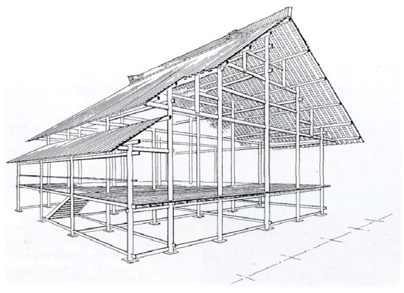
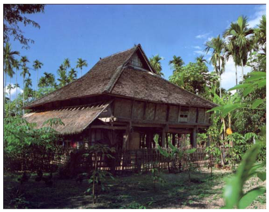
The vernacular architecture for this region is primarily based on timber construction as timber is the most common and locally available building material [17]. Figure 21, Figure 22, Figure 23, Figure 24 display the typical local housing—wooden storied house. Usually these houses consist of a small structure with three to five rooms, where all aspects of daily life and activities are carried out at the first floor level (Figure 21). Moreover, this structure keeps the dampness away from the structure as well as making it less vulnerable to robbery and attacks by wild animals. The housing material is a combination of bamboo and wooden frames, steep, thatched roofs with broadly sloping eaves, bamboo mats for floors and sitting area, and wide, open corridors in which to dry clothes. This type of the house gives protection from intensive solar radiation as well as rainfall, and also allows a prevailing breeze to cool the dwelling (Figure 22).
This vernacular housing type implies a mild climate with a high incidence of sunshine and precipitation. The outdoor environment should be reasonably pleasant throughout the year with an average annual air temperature close to the comfort range; and this is just the climate of Kunming—the chosen representative city for this region.
Figure 21.
Wooden storied house drawing [17].
Figure 21.
Wooden storied house drawing [17].
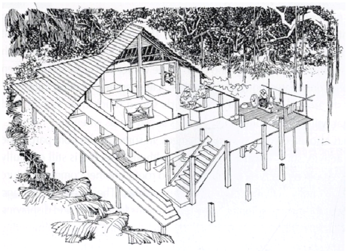
Figure 22.
After wooden storied house section, [17].
Figure 22.
After wooden storied house section, [17].

Figure 23.
Wooden storied structure [17].
Figure 23.
Wooden storied structure [17].

Figure 24.
Photo of wooden storied house [8].
Figure 24.
Photo of wooden storied house [8].
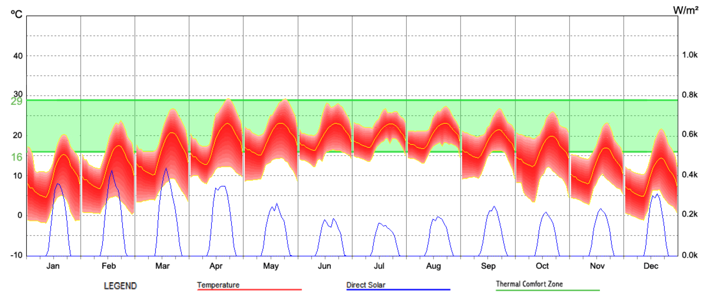
Kunming, the capital of Yunnan province, is located in the centre of Yunnan Province, at between 102–103° N longitude and between 24–26° N latitude. With 140 km from east to west and 220 km from south to north, Kunming covers 15,561 km2 and has a total population of 4 million [16]. The city is situated on top of a plateau and benefits from the protection of mountains on three sides, and a lake to the south. It is 1900 m above sea level and enjoys a low latitude mountain plateau monsoon climate. Additionally, because of the impact of warm and moist air from the southwest Indian Ocean, Kunming enjoys gentle mild weather that lasts all the year round.
Figure 25 and Table 3 displays the mild climate profile of Kunming. It can be observed that the outdoor air temperatures mostly remain within or close to the comfort range (or slightly cooler for a short period). Although the diurnal temperature is 5 °C for those mild months and 10 °C for cooler months, possessing an annual mean temperature of 16 °C, the climate itself becomes a comfort factor that requires few passive design strategies. The annual precipitation reaches 901mm, among which 85% occurs during May to October, and the annual average relative humidity is 64%. The city enjoys a fluent solar radiation too, with an annual average of 6.4 hours per day and the monthly values of global solar radiation on horizontal are in the range of 100–165 kWh/m². Indoor comfort can be easily achieved by utilizing this solar radiation in cooler months, although overheating possibilities remain if they are not effectively controlled. The priority for passive building designs in this mild climate is to provide sufficient solar access during cooler seasons whilst taking into account the potential for overheating. Thus, passive cooling strategies observed from vernacular architecture such as solar control and natural ventilation should also be considered.
Figure 25.
Kunming Climate Data, (MeteonormV6.1 data period: 1996–2005).
| Month | Ta | Ta dmin | Ta dmax | RH | H_Gh | H_Bn | SDm | SDd | SDastr | RR | RD | FF | DD |
|---|---|---|---|---|---|---|---|---|---|---|---|---|---|
| Jan | 9.5 | 4.4 | 15.3 | 58 | 115 | 141 | 222 | 7.2 | 10.6 | 22 | 2 | 2.4 | 279 |
| Feb | 11.9 | 6.7 | 17.9 | 51 | 125 | 137 | 221 | 7.9 | 11.2 | 20 | 3 | 2.9 | 142 |
| Mar | 15.2 | 10.1 | 21.1 | 47 | 159 | 142 | 255 | 8.2 | 11.9 | 30 | 3 | 3.2 | 142 |
| Apr | 18.1 | 12.6 | 23.3 | 48 | 165 | 137 | 244 | 8.1 | 12.6 | 32 | 4 | 3.2 | 142 |
| May | 19.2 | 14.9 | 23.6 | 60 | 154 | 97 | 214 | 6.9 | 13.2 | 90 | 9 | 2.8 | 142 |
| Jun | 20.1 | 16.3 | 23.4 | 73 | 124 | 64 | 136 | 4.5 | 13.6 | 181 | 14 | 2.4 | 176 |
| Jul | 20.1 | 17.1 | 23.3 | 78 | 121 | 63 | 139 | 4.5 | 13.4 | 175 | 16 | 2 | 142 |
| Aug | 19.9 | 16.7 | 23.4 | 76 | 126 | 72 | 155 | 5 | 12.9 | 132 | 16 | 1.9 | 142 |
| Sep | 18.2 | 14.5 | 21.8 | 72 | 112 | 82 | 135 | 4.5 | 12.2 | 80 | 12 | 2 | 279 |
| Oct | 16.2 | 12.5 | 20.1 | 74 | 101 | 66 | 149 | 4.8 | 11.5 | 88 | 11 | 2.1 | 279 |
| Nov | 12.4 | 7.9 | 17.1 | 69 | 100 | 99 | 172 | 5.7 | 10.8 | 29 | 5 | 2 | 279 |
| Dec | 9.3 | 4.7 | 15 | 67 | 104 | 136 | 199 | 6.4 | 10.5 | 22 | 2 | 2.1 | 279 |
| Year | 15.8 | - | - | 64 | 1506 | 1236 | 2241 | 6.4 | - | 901 | 97 | 2.4 | 182 |
Ta: air temperature (°C); Ta dmax: mean daily minimum Ta; Ta dmin: mean daily minimum Ta; RH: relative humidity; H_Gh: irradiation of global radiation horizontal; H_Bn: irradiation of beam (kWh/m2); SDm: sunshine duration monthly; SDd: sunshine duration daily (hours); SDastr: sunshine duration astronomic; RR: precipitation (mm); RD: days with precipitation; FF: wind speed (m/s); DD wind direction (°C).
5. Hot Summer and Cold Winter Region
Most of Central China is within the hot summer and cold winter region, which is also located within the warm temperate zone. The landscape in this region is a mix of plain and mountains, and the dominant climate is a long period of hot humid summer and a short and cool winter (Figure 26). Also, this is a densely populated area, which includes more than ten massive conurbations, like Shanghai, Wuhan, and Chengdu. The economy in this region is more developed than those regions previously mentioned in the text.
Figure 26.
Hot summer and cold winter region map.
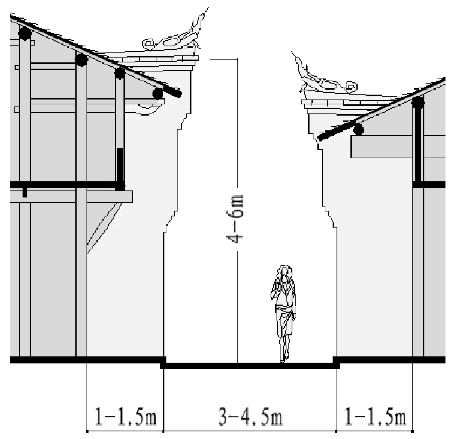
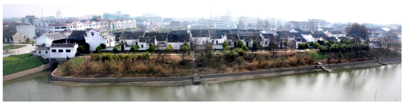
Like the cold region, the timber brick courtyard siheyuan remained typical of the vernacular architecture in this region for a considerable amount of time. However, the siheyuan here was much more compact than it was in the north of the country, and, moreover, usually appeared in compressed groups so as to control solar gain. Figure 27 shows a plan of a typical that was constructed in the 1930s and which survives up to the present day. In this village, siheyuans were arrayed next to each other along the main street, whilst the street facing part of the building was used for shops and the rear side for residence. This compact site layout demonstrates effective solar control as the grouped buildings create narrow streets with white walls and shaded veranda places in order to deflect solar rays thus enabling it to cool down during hot weather (Figure 28, Figure 29).
Figure 27.
Zhai J.W. village plan.
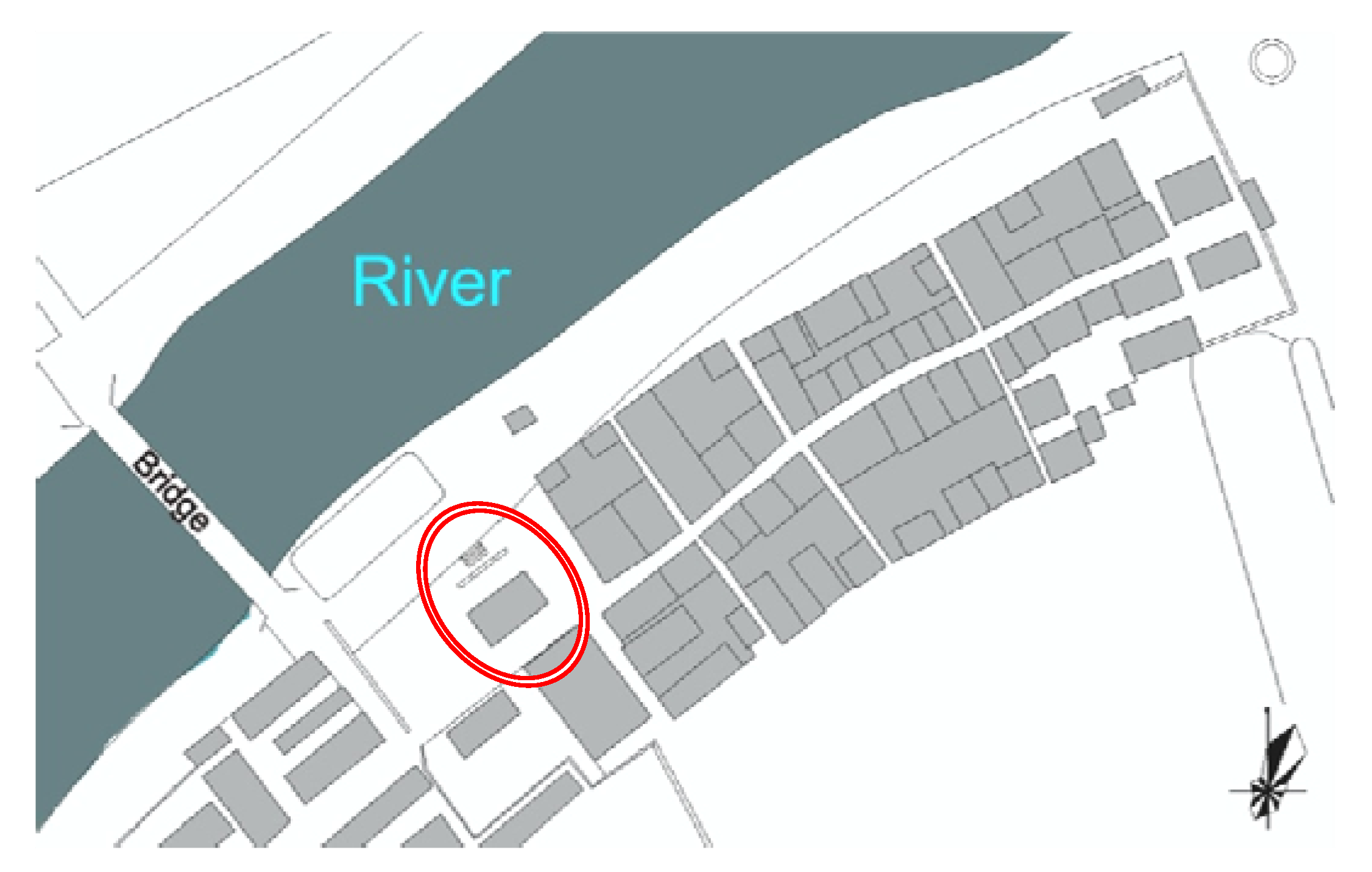
Figure 28.
Street section.

Figure 29.
Zhai J.W. Village photo from river side [18].
Figure 29.
Zhai J.W. Village photo from river side [18].
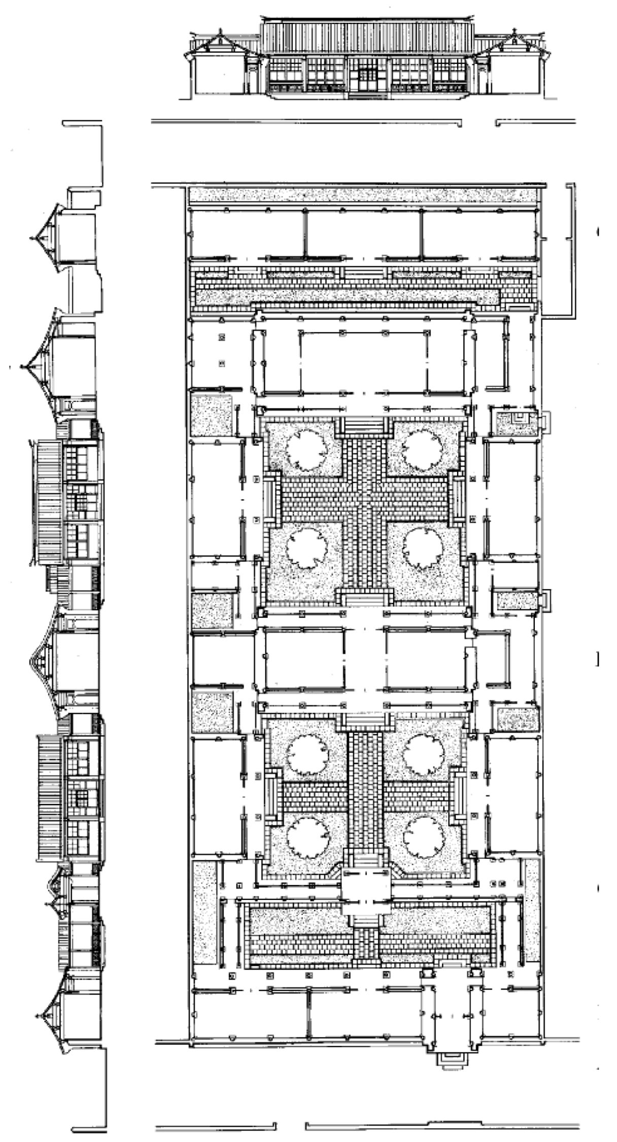
Focusing on one siheyuan (red circle shown in Figure 27), Figure 30, Figure 31 display its plan, elevation and sections. It can be seen that the entire building scale, especially the courtyard (shown in grey) is totally different from those discussed in reference to the cold region, since it is spacious in the north and compact in the south.
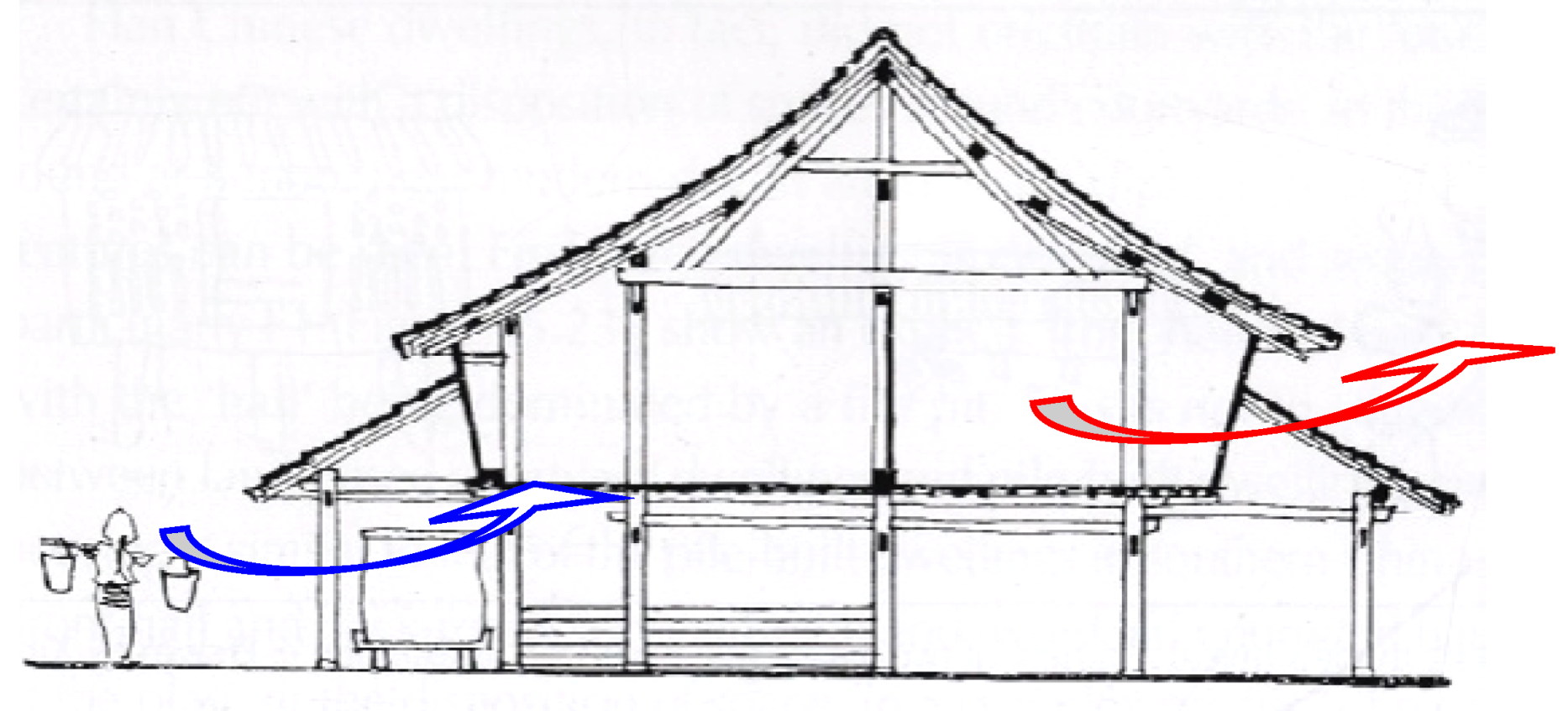
This siheyuan was built 90 years ago for a merchant; it is 11 m wide, 24 m deep, with a total floor area of 400 m2 (two partial stories). The building is facing the main road, where the shop has been arranged at the front and residential area at the back. The house is mainly north—south facing with a small deviation to the east; it gets adequate shading from the east and the west side benefiting from its intermediate location. The small courtyard is the key functional space within the entire building that connects the front shop and the residence. Firstly, being a deep plan, the skylights bring sufficient daylight into the house, allowing hot air to escape through the top so as to ventilate the building (Figure 32, Figure 33, Figure 34). Interestingly, a limestone (Figure 30 blue circle) can be usually found in the semi-opened courtyard, and its purpose is two-fold: weather forecasting and a place to chop firewood. This is because in warm and humid climates, tiny water drops can be seen on the cold limestone surface before it rains and the floor is usually made from bricks, which do not provide a strong enough surface for chopping firewood [19].
The passive strategies used in the vernacular architecture indicate a warm and humid climate. Wuhan (30°35’ N, 114°18’ E) is representative of the cities within this region, since it is located in the subtropical humid climate zone and has four distinct seasons with a signature warm and humid summer. It is generally an industrial and educational city with a population of 7.8 million people, covering an area of 8,500 km2, of which the urban area covers 4,000 km2 [16].
In China, apart from the desert in Xinjiang province, the second hottest area is the valley along the Yangtze River, cities in this area are: Wuhan, Chongqing and Nanjing [20]. These three cities together are famous as the “Three Burners”. Certainly, a number of topographical features contribute to this climate.
One of the biggest weather fronts, that influence China’s climate the most, is the Mai-yu front. According to the study by Barry & Chorley (1998), it involves both the monsoon trough and the East Asian-West Pacific Polar Front, with weak disturbances moving eastwards along the Yangtze valley and occasional cold fronts from the northwest [21]. It shifts from the south of the Yangtze River in early May and moves to the north of it by the end of the month. It reaches northern China in mid-July. Usually, in July, after this rainfall has moved to the north, this area is completely controlled by the subtropical anticyclone belt. The subsiding anticyclone makes the temperature rise, often causing droughts. During this period, according to traditional views, it is always a clear sky and weak wind, with intensive solar radiation. And this is the main reason why the city is given as the name of the “Burner”.
Figure 30.
Zhai, S.B. House Plan and Section.
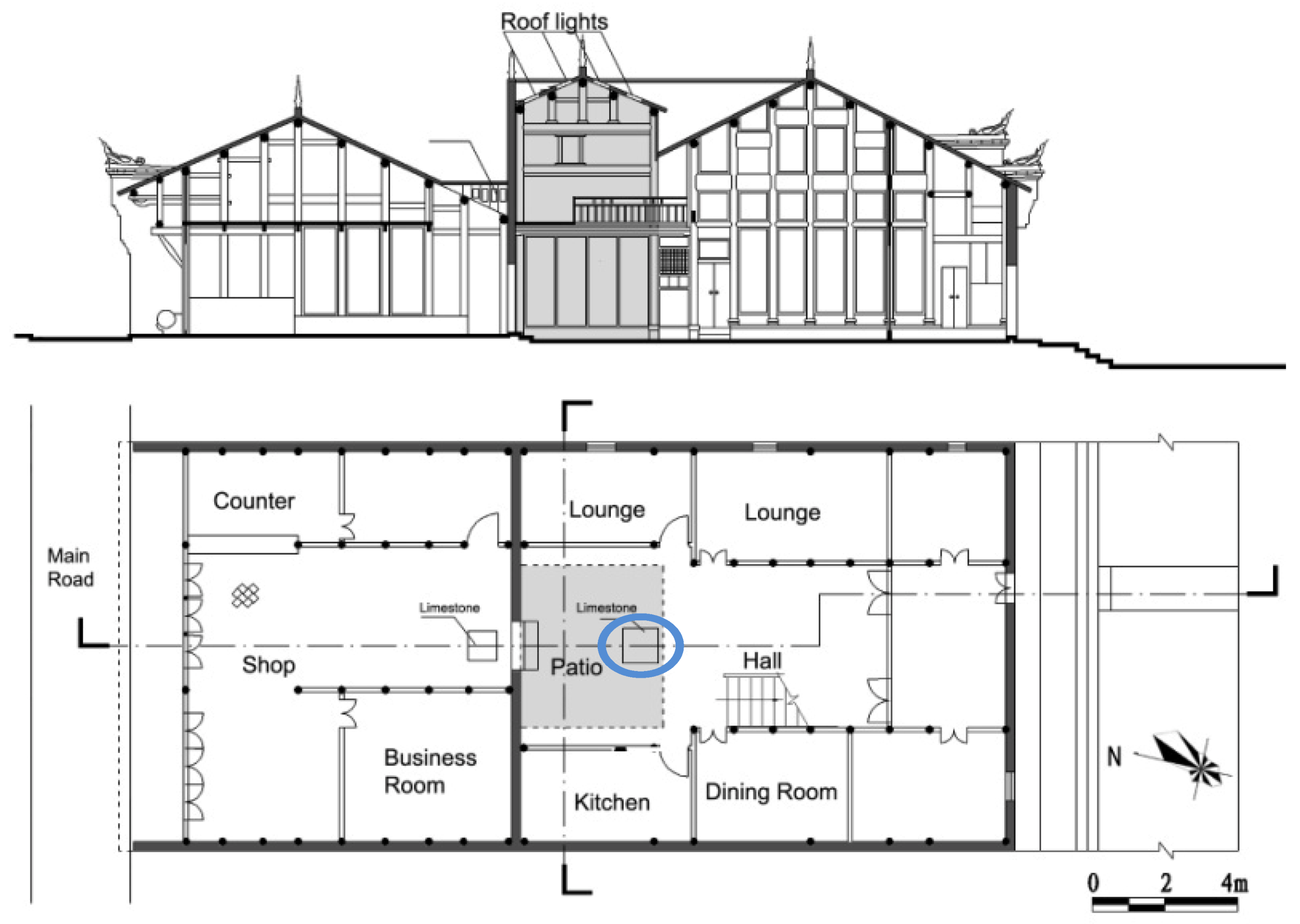
Figure 31.
Zhai, S.B. House elevation and section.
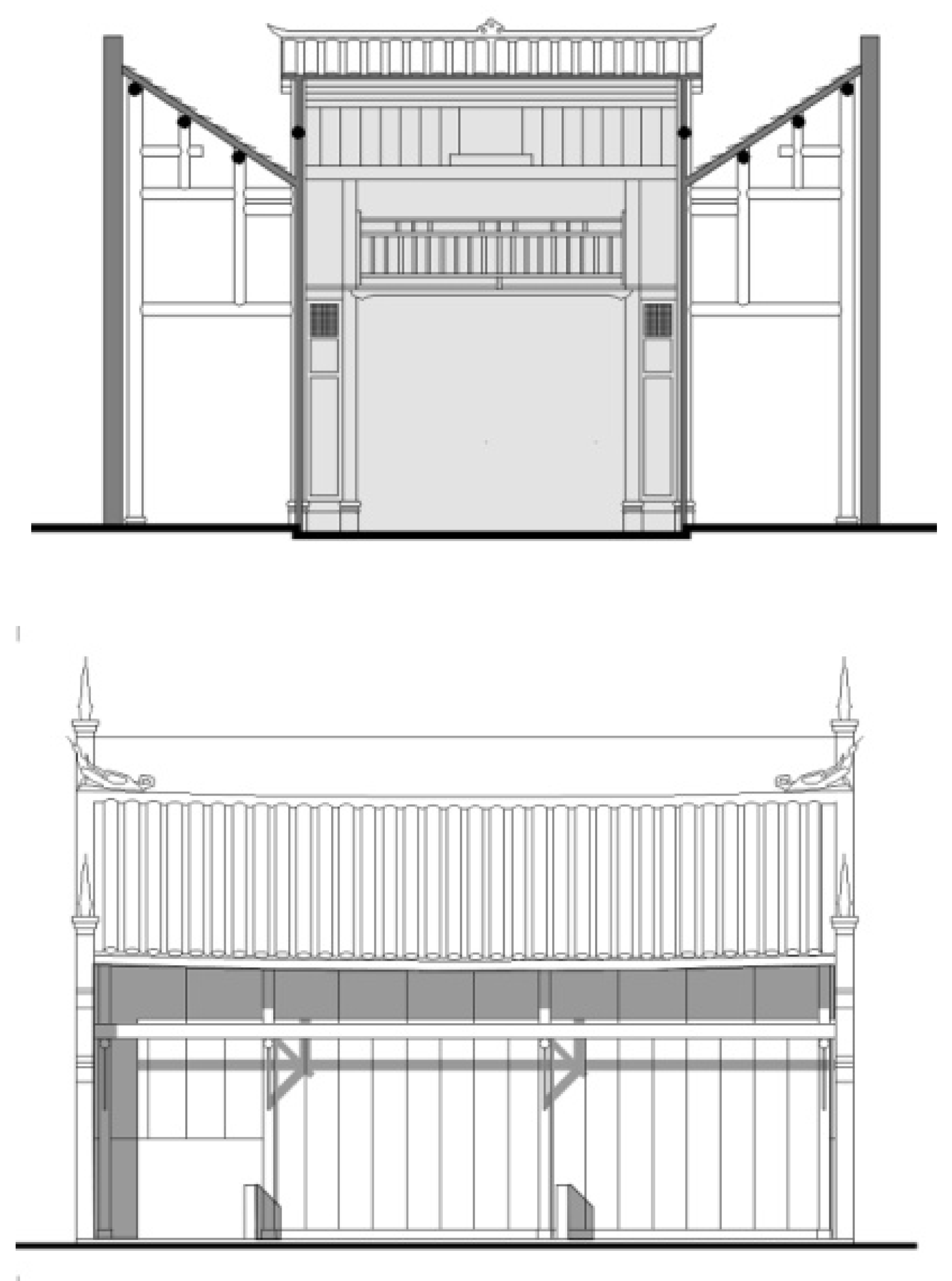
Figure 32.
Roof lights photo [18].
Figure 32.
Roof lights photo [18].
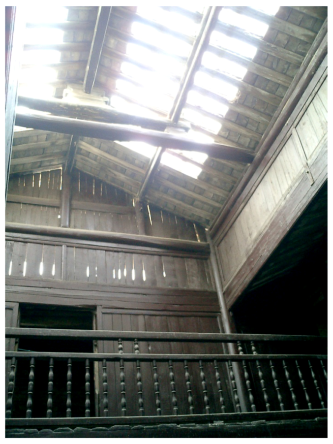
Figure 33.
Ventilation of the roof.
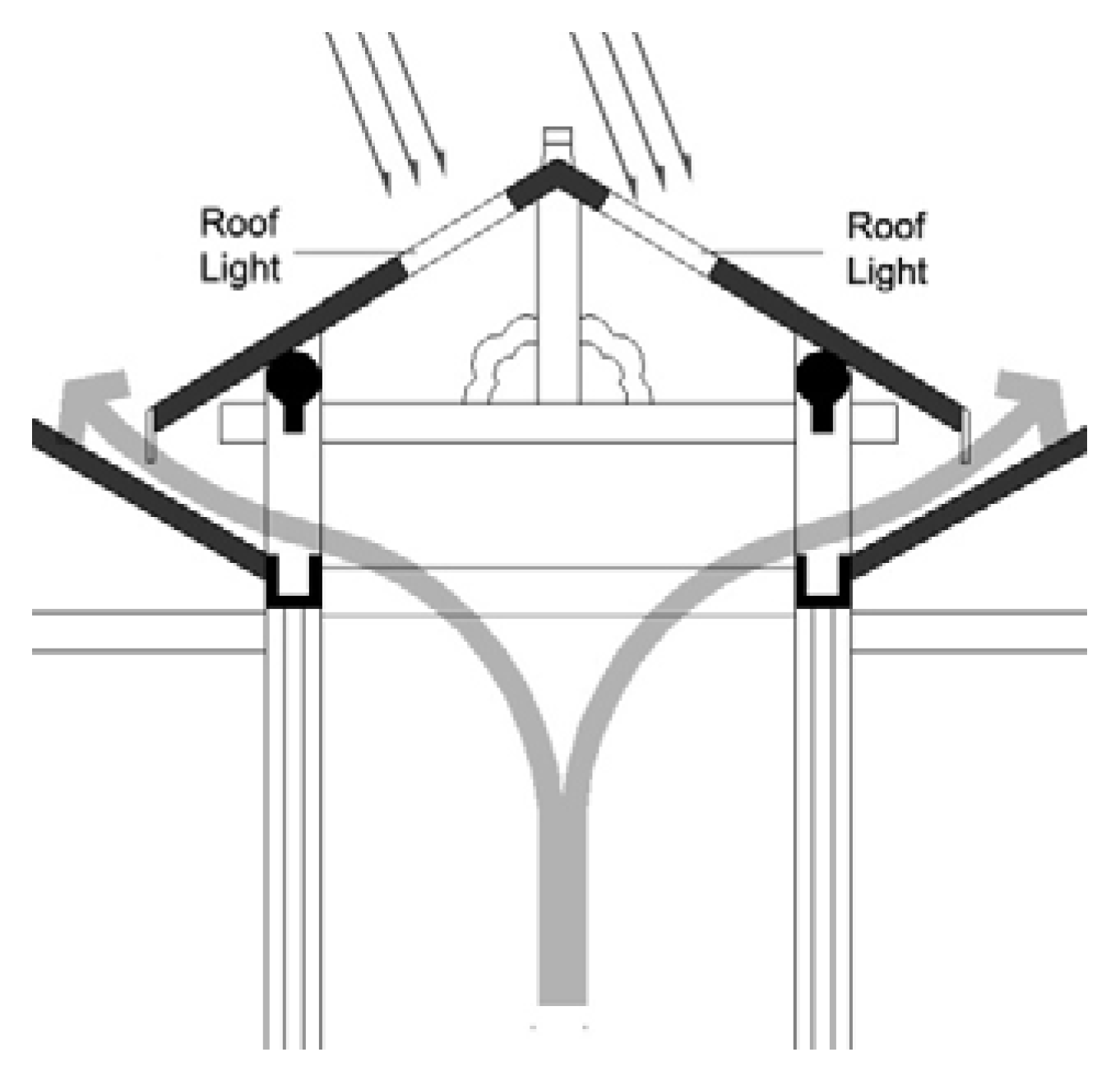
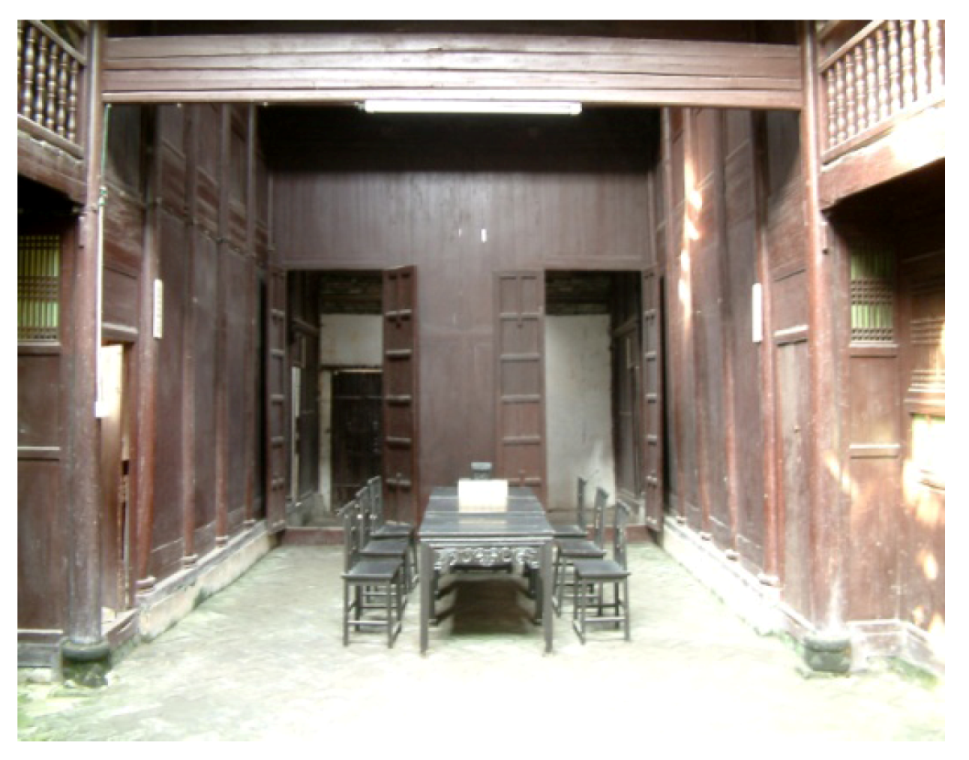
Figure 34.
Hall photo (beneath roof lights) [18].
Figure 34.
Hall photo (beneath roof lights) [18].
Secondly, the location within the basin area makes heat dissipation more difficult. Wuhan is located at the bottom of Yangtze valley and the average land area is 50 m below sea level [22]. When the prevailing southeast wind crosses the surrounding cordillera and reaches the basin, the subsidence creates a hot dry wind, which causes severe weather conditions.
The third factor is water. Downstream of the Yangtze River is the area that possesses the highest concentration of freshwater in China [20]. Apart from this, this area is full of paddy fields, which produces the main staple food source, rice. The broad area of water helps to increase the air moisture, which absorbs more heat and prevents the reflective heat from the ground rising to the sky. All of these factors result in Wuhan’s so-called “Burner” climate.
Generally, according to the data from Meteonorm V6.1 (Figure 35, Table 4), there are three distinct periods: a four-month period of hot weather (June to September inclusive) characterised by mean daily ambient temperatures of 24–29 °C; a cold winter (December to February) with mean ambient temperatures of 5–8 °C and the mild transaction period with the figure of 12–23 °C. Apart from the moderate transaction months, where the outdoor air temperatures are largely within or near the comfort range, this temperature profile indicates that both summer and winter comfort should be addressed in climate-responsive design. Although the relative humidity remains basically stable throughout the year—77%, however, at the peak of the hot period (July and August) the wet-bulb temperature rises to 25–26 °C, which is the limiting range for direct evaporative cooling. Sunshine is stronger in hot days than it is in the cold weather, with an average daily duration of 7 hours and 2.5 hours respectively. The monthly values of global radiation on horizontal are in the range of 84–222 W/m². The prevailing winds are from the northwest during the winter, whilst southeast in summer with an average annual speed of 1.4 m/s. Precipitation occurs all year and peaks during the monsoon (May to July) with an average annual figure of 106 mm.
Figure 35.
Wuhan Climate Data (MeteonormV6.1 data period: 1996–2005).
| Month | Ta | Ta dmin | Ta dmax | RH | H_Gh | H_Bn | SDm | SDd | SDastr | RR | RD | FF | DD |
|---|---|---|---|---|---|---|---|---|---|---|---|---|---|
| Jan | 4.6 | 1.7 | 7.9 | 71 | 62 | 43 | 91 | 2.9 | 10.2 | 67 | 5 | 1.5 | 198 |
| Feb | 7.6 | 4.2 | 11.2 | 68 | 67 | 29 | 80 | 2.9 | 11 | 63 | 6 | 1.6 | 23 |
| Mar | 11.7 | 8.3 | 15.6 | 70 | 86 | 34 | 99 | 3.2 | 11.8 | 89 | 9 | 1.8 | 81 |
| Apr | 18.2 | 14.1 | 22.1 | 70 | 107 | 40 | 122 | 4.1 | 12.8 | 135 | 11 | 1.9 | 81 |
| May | 22.9 | 19.5 | 26.7 | 71 | 138 | 60 | 147 | 4.7 | 13.6 | 166 | 11 | 1.7 | 81 |
| Jun | 26.5 | 22.9 | 29.3 | 75 | 135 | 49 | 160 | 5.3 | 14 | 171 | 10 | 1.7 | 81 |
| Jul | 29.4 | 26.2 | 32.5 | 75 | 165 | 90 | 209 | 6.7 | 13.8 | 202 | 10 | 1.8 | 110 |
| Aug | 28.2 | 25.3 | 31.4 | 76 | 150 | 87 | 213 | 6.9 | 13.1 | 117 | 10 | 1.9 | 81 |
| Sep | 24.8 | 20.8 | 28.1 | 70 | 116 | 59 | 148 | 4.9 | 12.2 | 57 | 8 | 1.9 | 66 |
| Oct | 18.6 | 15.1 | 22.4 | 71 | 93 | 57 | 132 | 4.3 | 11.3 | 80 | 8 | 1.6 | 66 |
| Nov | 12.4 | 8.7 | 16.1 | 71 | 70 | 54 | 112 | 3.7 | 10.5 | 80 | 6 | 1.5 | 212 |
| Dec | 6.4 | 3.3 | 10.3 | 70 | 62 | 44 | 101 | 3.3 | 10 | 39 | 4 | 1.6 | 198 |
| Year | 17.6 | - | - | 72 | 1249 | 646 | 1613 | 4.6 | - | 1266 | 98 | 1.7 | 92 |
Ta: air temperature (°C); Ta dmax: mean daily minimum Ta; Ta dmin: mean daily minimum Ta; RH: relative humidity; H_Gh: irradiation of global radiation horizontal; H_Bn: irradiation of beam (kWh/m2); SDm: sunshine duration monthly; SDd: sunshine duration daily (hours); SDastr: sunshine duration astronomic;RR: precipitation (mm); RD: days with precipitation; FF: wind speed (m/s); DD wind direction (°C).
As in the cold region, passive building designs for this climate should focus on energy balance with special regards to summer comfort, as evaporative cooling will not be an effective prospect during hot months. Apart from obtaining passive solar gains and reducing heat loss during the winter, sufficient solar controls, promoting effective ventilation and passive cooling by natural means should be the priority for climate-responsive buildings.
6. Hot Summer and Mild Winter Region
The southeast coastline together with the two main islands (Hainan and Taiwan) constitutes the hot summer and mild winter region (Figure 36). This region can be described as the most technically advanced developed region of the five, since it covers Guangzhou, Shenzhen and Hong Kong. Huge numbers of people have migrated here and large cities have grown as a result, although there are also medium-sized and small cities like Haikou and Shanya, which are inhabited by minorities or serve as satellite cities.
Figure 36.
Hot summer and mild winter region map.

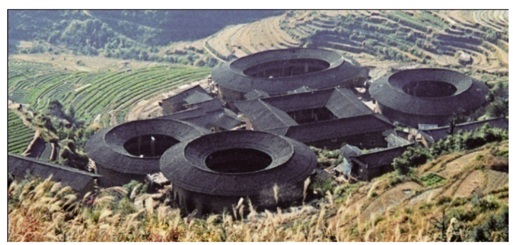
Situated within the tropical humid summer zone, this region has a tropical moist monsoonal climate. Over the centuries, residents have settled down in this land and their interpretation of the environment in this region can be understood by looking at their vernacular architecture, which prioritises natural ventilation and shading, and, thus, is often characterized by big overhanging roofs that are usually made from plants. Compact siheyuan groups continue to flourish here just like those discussed in the previous region. However, there is one more housing form worth mentioning, the tulou in Fujian province (Figure 37).
Figure 37.
Tolou group [4].
Figure 37.
Tolou group [4].

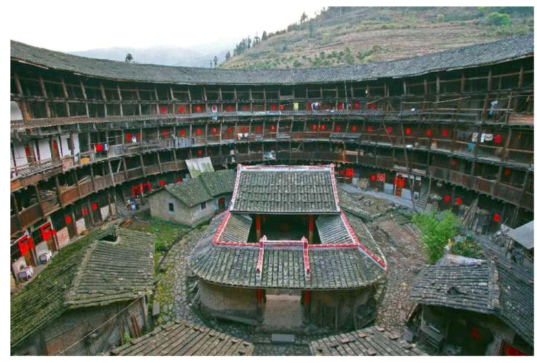
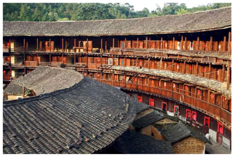
Tolou, the Chinese words for clay building, has an architectural volume that is rarely seen among vernacular dwellings in other parts of China [8]: Several stories high, they are built along an inward-looking, round or square floor plan and housing up to 800 people each. Usually they were built for defensive purposes around a central open courtyard with only one entrance and the windows are located only above the first floor (Figure 38). Housing a whole clan, tolou functioned as village units and were known as “a little kingdom for the family” or “bustling small city.” They feature high fortified mud walls covered by tiled roofs with wide over-hanging eaves. The buildings were divided vertically between families with each possessing two or three rooms on each floor. Kitchen and dining room were generally placed on the first floor; the storage rooms were on the second floor; while the bedrooms were placed on the third or higher floors. The base wall is 3 m thick and the first floor is 1.5 m thick, as the thickness of the wall was reduced higher up in the structure. In contrast with their plain exterior, the interiors were built for comfort and were often highly decorated; the ancestral hall, private school and stage are placed in the center (Figure 39, Figure 40).
Figure 38.
Tulou from outside [8].
Figure 38.
Tulou from outside [8].
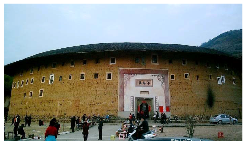
Figure 39.
Tulou from inside [23].
Figure 39.
Tulou from inside [23].

Figure 40.
Tulou rooms [23].
Figure 40.
Tulou rooms [23].

Interestingly, the tulou demonstrate another interpretation of climate-responsive buildings in a hot climate, when traditional passive cooling strategies such as solar control and cross ventilation are not prospective due to security reasons—the use of thermal mass. The several meter-thick clay walls have a high capacity for heat storage, where heat can be stored during day time and released at night, allowing the indoor environment to be maintained at a relatively stable and pleasant temperature.
Haikou is the capital of Hainan province and also the representative case study for this region. It is situated in the north of Hainan Island between 19.57–20.05° N and 110.10–110.23° E in the southernmost part of China. It is estimated that in 2007, the constructed urban area covered a total of 34 km2, housing a population of 631,179 [16].
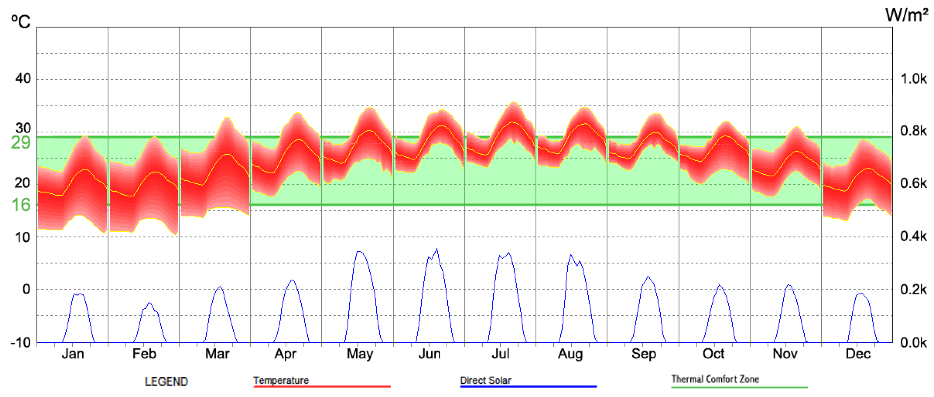
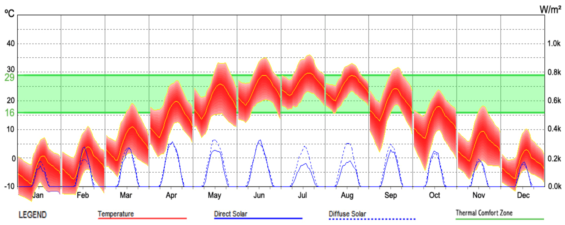
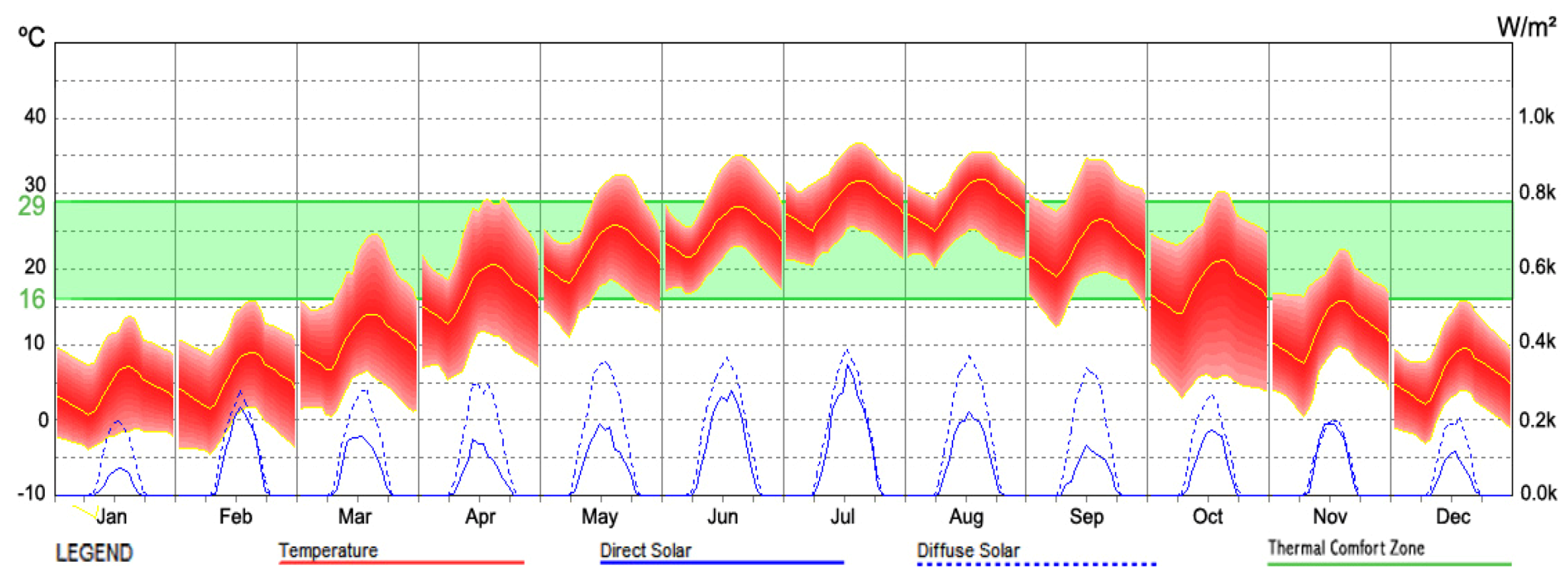
Haikou lies in the monsoon tropical zone with an annual temperature of 25 °C. There is no obvious change in different seasons as the dominant weather is hot and humid throughout the year (Figure 41). July and August are the hottest months with an average temperature of about 29 °C. January is the coolest, with a temperature of about 20 °C. The rainfall here is plentiful, with occasional typhoons. Every year, from April to October is the tropical storm and typhoon season, and most of these occur between August and September [20]. May to October is the rainy season with an average monthly precipitation of 301 mm. The average annual relative humidity is 80% with a mean wet-bulb temperature of 24–26 °C from May to September, and this inhibits evaporative cooling. Sunshine is strong throughout the year with an annual average of 6.5 hours of bright sunshine per day. Daily values of global solar radiation on the horizontal are in the range of 2.5–8.5 kWh/m². Details of the climatic data are shown in Table 5.
Figure 41.
Haikou Climate Data (MeteonormV6.1 data period: 1996–2005).

| Month | Ta | Ta dmin | Ta dmax | RH | H_Gh | H_Bn | SDm | SDd | SDastr | RR | RD | FF | DD |
|---|---|---|---|---|---|---|---|---|---|---|---|---|---|
| Jan | 20.1 | 17.6 | 22.8 | 77 | 97 | 70 | 123 | 4 | 10.9 | 15 | 4 | 2.8 | 181 |
| Feb | 20.2 | 17.4 | 23.1 | 80 | 89 | 42 | 101 | 3.6 | 11.4 | 44 | 6 | 3 | 119 |
| Mar | 22.6 | 19.8 | 25.9 | 83 | 116 | 58 | 140 | 4.5 | 11.9 | 45 | 6 | 3.1 | 124 |
| Apr | 25.5 | 22.1 | 28.5 | 83 | 131 | 60 | 170 | 5.7 | 12.5 | 68 | 8 | 3.1 | 124 |
| May | 27.1 | 24 | 30.4 | 84 | 171 | 114 | 224 | 7.2 | 13 | 177 | 12 | 3 | 119 |
| Jun | 28.3 | 24.7 | 31.3 | 82 | 167 | 116 | 219 | 7.3 | 13.2 | 162 | 12 | 3 | 136 |
| Jul | 28.8 | 25.6 | 32.1 | 80 | 175 | 120 | 254 | 8.2 | 13.1 | 247 | 11 | 3 | 225 |
| Aug | 28.7 | 25.8 | 31.8 | 80 | 169 | 113 | 220 | 7.1 | 12.7 | 276 | 12 | 2.7 | 121 |
| Sep | 27.8 | 25.1 | 30.1 | 80 | 132 | 73 | 194 | 6.5 | 12.1 | 313 | 12 | 2.6 | 181 |
| Oct | 26.9 | 24.6 | 29.5 | 75 | 122 | 69 | 184 | 5.9 | 11.6 | 162 | 10 | 2.8 | 181 |
| Nov | 24.2 | 21.6 | 26.4 | 74 | 103 | 69 | 148 | 4.9 | 11.1 | 46 | 6 | 3 | 176 |
| Dec | 20.8 | 18.6 | 23.3 | 73 | 93 | 66 | 141 | 4.5 | 10.8 | 48 | 4 | 3 | 176 |
| Year | 25.1 | 79 | 1561 | 970 | 2119 | 6 | 1603 | 103 | 2.9 | 154 |
Ta: air temperature (°C); Ta dmax: mean daily minimum Ta; Ta dmin: mean daily minimum Ta; RH: relative humidity; H_Gh: irradiation of global radiation horizontal; H_Bn: irradiation of beam (kWh/m2); SDm: sunshine duration monthly; SDd: sunshine duration daily (hours); SDastr: sunshine duration astronomic; RR: precipitation (mm); RD: days with precipitation; FF: wind speed (m/s); DD wind direction (°C)
Having analyzed the climate, the correct response with regard to sustainable building designs should emphasize passive cooling practices only. Solar controls and ventilation are the key contributors and prospective evaporative cooling only occurs from October to April. In situations where traditional passive cooling is difficult to achieve, heavy insulation should be compensated.
7. Conclusions
This paper has explored the climatic conditions that cover five different regions as well as the corresponding climate-responsive vernacular dwellings. As latitude ranges from high to the low, the climate differs from subarctic to tropical and the vernacular dwelling design strategies have also varied and responded to the local climate with surprising efficiency (summarized in Table 6).
| Regions | Passive Solar Gains | Thermal Capacity | Airtightness | Passive Solar Controls | Ventilation |
|---|---|---|---|---|---|
| Severe Cold | √ | √ | √ | ||
| Cold | √ | √ | √ | √ | √ |
| Moderate | √ | √ | |||
| Hot Summer & Cold Winter | √ | √ | √ | √ | √ |
| Hot Summer & Warm Winter | √ | √ |
For north part of the country, the dominant climate is cold and humid with occasional warm weather. Climate-responsive designs within this region should aim at passive solar heating and reducing heat loss through sufficient thermal capacity and airtight building envelope so as to maintain indoor comfort. In addition, some attention should also be paid to passive cooling strategies as there is a small risk of overheating.
The central part of China has a cold winter and warm summer climate, which requires energy balancing through passive means all year round for sustainable building designs. Building designs should allow passive solar gains and solar controls to be adjusted efficiently according to the weather changes. The building envelope requires adequate thermal initial to function as thermal insulation for both summer and winter. Additionally, airtightness and natural ventilation should also be considered in building designs.
There is a small part of southwest that enjoys a moderate pleasant climate, where little effort is needed to achieve indoor comfort. The Southeast has a warm and humid climate, where the correct climate interpretation for building designs is passive cooling, specifically solar control and natural ventilation; and this is due to long period strong solar radiation and high levels of absolute humidity in the hot period.
The vernacular housing is a rational response to the climate in terms of material, passive techniques and local environment: they have functioned well and housed Chinese people for thousands of years. Siheyuan is one of the typical dwelling forms that exist in all regions of China, with regional variations according to the regional climate.
Acknowledgements
This paper is partial of the Ph.D. thesis undertaken at the Architectural Association School of Architecture, associated with a scholarship from Beijing Institute of China Construction and Design Research, Wuhan Branch and under the supervision of Simos Yannas and Rosa Schiano-Phan. The author would like to indicate appreciation to all the support obtained.
References
- Veeck, G.; Pannell, C.W.; Smith, C.J.; Huang, Y.Q. China’s Geography: Globalization and the Dynamics of Political, Economic, and Social Change; Rowman & Littlefield Publishers: Lanham, MD, USA, 2007. [Google Scholar]
- Fu, C.B.; Jiang, Z.H.; Guan, Z.Y.; He, J.H.; Xu, Z.F. Regional Climate Studies of China; Springer–Verlag Berlin Heidelberg: Berlin, Germany, 2008. [Google Scholar]
- Earth-To-Map GIS Inc. Image Map of China. Available online: http://www.e2mgis.com/e2mportal/Portals/0/Images/Projects/Gallery/china_image_map_en.jpg (accessed on 20 January 2013).
- Shan, D.Q. Chinese Vernacular Dwelling; China Intercontinental Press: Beijing, China, 2004. [Google Scholar]
- MIT Sustainable Urban Housing. Map of Vernacular Architecture in China. Available online: http://chinahousing.mit.edu/english/china/vernacular/index.html (accessed on 20 January 2013).
- Harbin Yearbook Press (HYP), Harbin Yearbook 2009; (in Chinese). Fang Zhi Press: Hong Kong, China, 2010.
- Architectural Institute of the Republic of China (AIC), Chinese Vernacular Architecture; Jiangsu Science & Technology Press: Nanjing, China, 1999.
- Lou, Q.X. Twenty Lectures on Chinese History Architecture; Shan Lian Publication Ltd.: Beijing, China, 2001. [Google Scholar]
- Gansu Archive, Chinese Folk—Liaoning; (in Chinese). Chinese Folk Editorial Committee, Gansu People’s Press: Lanzhou, China, 2008.
- Men, R. Origin of Everything; China Economy Press: Beijing, China, 2004. [Google Scholar]
- Zhuang, Z.; Li, Y.G.; Chen, B.; Guo, J.Y. Chinese Kang as a domestic heating system in rural northern China—A review. Energy Build. 2009, 41, 111–119. [Google Scholar] [CrossRef]
- Shen, F.X. China Ancient Architecture Culture; Shanghai Guji Press: Shanghai, China, 2001. [Google Scholar]
- Guo, W.K. The Amazing Caves, Qing Yang History; Gan Su Culture Publisher: Lanzhou, China, 2004. [Google Scholar]
- Zheng, Y.M. Cave-Dwelling—Vernacular Housing of Yan’an. (in Chinese). Available online: http://shengdibaige.blog.163.com/blog/static/8753115720103481617334/ (accessed on 20January 2013).
- Ren, H.B. Feng Shui and Chinese Traditional Domestic Architecture.
- National Bureau of Statistic of China. China 6th Census Data, 1st November 2010. (in Chinese). Available online: http://www.stats.gov.cn/tjgb/rkpcgb/ (accessed on 20 January 2013).
- Knapp, R.G. Asia’s Old Dwellings; Oxford University Press: Oxford, UK, 2003. [Google Scholar]
- He, Z.H. Research on Zhai Jia Wan Old Village, Honghu City, Hubei Province.
- Xiao, J.K. Hubei Folk and Custom; Gansu People’s Press: Lanzhou, China, 2008. [Google Scholar]
- China Meteorological Administration (CMA). China Meteorological Data Sharing Service System. (in Chinese). Available online: http://cdc.cma.gov.cn/home.do (accessed on 20 January 2013).
- Barry, R.G.; Chorley, R.J. Atmosphere, Weather & Climate, 7th ed; Routledge: London, UK, 1998. [Google Scholar]
- Zheng, P. China Geography; China Intercontinental Press: Beijing, China, 2006. [Google Scholar]
- Song, X.L. Fujian Tulou. 2008. Available online: http://whc.unesco.org/en/list/1113/ (accessed on 20 January 2013).
© 2013 by the authors; licensee MDPI, Basel, Switzerland. This article is an open access article distributed under the terms and conditions of the Creative Commons Attribution license (http://creativecommons.org/licenses/by/3.0/).
Share and Cite
MDPI and ACS Style
Sun, F. Chinese Climate and Vernacular Dwellings. Buildings 2013, 3, 143-172. https://doi.org/10.3390/buildings3010143
AMA Style
Sun F. Chinese Climate and Vernacular Dwellings. Buildings. 2013; 3(1):143-172. https://doi.org/10.3390/buildings3010143
Chicago/Turabian StyleSun, Feifei. 2013. "Chinese Climate and Vernacular Dwellings" Buildings 3, no. 1: 143-172. https://doi.org/10.3390/buildings3010143