
History as an Instrument in the Development of Historical Danish Villages


Cultural Heritage, Transformation and Restoration, Institute of Architecture and Culture, The Royal Danish Academy of Fine Arts, Schools of Architecture, Design and Conservation, Philip de Langes Allé 10, 1435 Copenhagen K, Denmark
Buildings 2016, 6(4), 51; https://doi.org/10.3390/buildings6040051
Submission received: 30 July 2016
/
Revised: 25 November 2016
/
Accepted: 7 December 2016
/
Published: 14 December 2016
(This article belongs to the Special Issue Sustainable Building in Rural Areas)
Abstract
:A central contemporary societal discussion in Denmark concerns settlements that have poor connectivity and are geographically distant to main towns and cities. These settlements are called “outskirts.” Historically significant villages in these outskirts are being transformed in order to counteract a general destitution of decrepit houses and public spaces. This research article explains the relationship between spatial alterations and the inherent historical structures these villages contain. The article analyses three student projects and examines how they relate to and gain from history in the development plans for a concrete exemplary case village in Denmark. The projects represent various ways in which the past is conceived and applied to the suggested concepts. The different approaches to history found in the student projects call for an open-minded position towards the assessment of historical structures worthy of preservation when operating in a generic context such as the Danish villages. Further, the students’ prioritisation of preservation of historical structures and phenomena alters from the analysis phase to the project development phase. This observation questions the traditional practice of developing plans based on a predefined analysis of heritage and suggests that heritage assessment be separated from project development.
1. Introduction
Within recent years “Udkantsdanmark”, which translates into Outskirt-Denmark, has become a key concept in the Danish public debate regarding societal development. The concept is vaguely defined, but Outskirt-Denmark includes large parts of the country that are geographically distant from or, in terms of infrastructure, are not well connected to the main towns and cities. Among the many factors that characterise the peripheral rural areas are a high level of empty housing stock, low or negative population growth, high average age and low educational level [1,2].
Media often present outskirts in a way which stigmatises their aesthetic characteristics. Pictures showing the physical decay of houses and public spaces appear to be synonymous with societal problems and it seems evident that this perception of “ugliness” related to the physical decay is linked to the idea of outskirts. This interpretation is supported by numerous political actions which aim to increase the quality of spatial conditions. Among these are governmental support for the demolition of empty and decaying houses, opportunities for the municipalities to abolish the residency requirements making it possible for people to transform all-year houses into holiday homes and support the reconstruction of public spaces [3]. Further, recent repeals of regulations in national planning acts assign greater responsibility to the municipal level [1]. Such decentralisation has resulted in concern that regional competition for investments will counteract long-term and large-scale interests in planning policies [4].
It is reasonable to anticipate profound changes to the physical conditions of these areas in the coming decades given the social problems and structural changes in society and governmental initiatives occurring in the peripheral rural areas. Accordingly, architectural considerations about these changes are urgent. From an academic architectural perspective, the problems and the ongoing transformations have not received much attention even though it is a matter of severe public concern.
With an idea of outskirts as outlined above, one might argue that areas perceived as such are by definition unsustainable. The term generally refers to a set of problems related to an existing situation or to plausible pending developments. Approaching the outskirts from the perspective of sustainable development, there are abundant aspects to address, which all seem critical. The consumption of energy for personal transportation and energy use for heating in the decentralised low-density settlements are issues of righteous attention relating to environmental perspectives on sustainability. Economic issues such as the development on the real-estate market are addressed and social issues of segregation of gender, age, income or educational level in the outskirts are being discussed. However, more cultural perspectives on the settlements seem less exposed. Ascending changes in Denmark—accelerated by political support for demolition of houses and renovation of public spaces—call for an increased awareness of cultural heritage worthy of preservation. A municipal engagement with this increased awareness ought to be informed by recent theoretical developments that oppose traditional approaches in order to be more inclusive to multiple cultures and identities. This article focuses on the transformation of history into heritage as a matter of great importance in the strive for a sustainable development for historical villages in Danish outskirts.
The settlement structures in rural Denmark tell a central story about the development of Danish society including the development of Denmark as a nation. The village has been the traditional frame for settlement in the landscape and even today the built structures function as a key narrator in our understanding of historic development. This notion places the historic dimension centrally in the discussion about the ongoing spatial changes in the peripheral regions. A comprehensive description of Danish history from the perspective of the villages has been conducted by Erland Porsmose in “Danske Landsbyer” [5]. The following is a brief overview of the pivotal events defining the generic history of the villages extracted from Porsmose.
The construction of medieval churches during the 11th and 12th century defines the Christianisation and transition from Viking Age to Middle Age. The new and heavy church construction constitutes the foundation of what we now understand as villages. This introduced a rather stable period. New villages were evolving from the church villages throughout the entire country during the following centuries forming the basic urban structure we know today.
Inspired by the Enlightenment, great societal reforms were implemented in the late 18th century. This included the radical restructuring and relocation of farms, aimed at rationalising cultivation procedures. The fields of farms were relocated according to two ideal models, but most commonly as a combination of these. One ideal model was the block-relocation that divided the land into approximated squares. The farms were dismantled and moved out of the village and reconstructed in the middle of new fields. This was possible due to the predominant flexible timber frame constructions. This model completely dissolved the former village structures in some regions of the country. The other ideal model was the star-relocation. Here, the fields were distributed as a star around the village. The farm stayed at the original location and was allocated the appurtenant field making it possible to sustain the village as a physical cluster. The star-relocation was preferred among many surveyors responsible for the process, which is the reason why in Denmark many village structures from the medieval period are still legible. Parallel to the physical relocation, many reforms of ownership, social conditions and methods of cultivation were initiated throughout the first half of the 19th century. At all levels, these reforms radically changed the settlement structure, e.g., decentralisation of ownership to the land led to significant partitioning in many regions.
The second half of the 19th century marked a new period in the history of the villages dominated by the emergence of cooperatives. Led by cooperative dairies, a massive movement of consumer cooperatives, cooperative abattoirs and corresponding unions for economic, educational and social cooperations were formed. Their great success gave rise to a new golden era for the villages and, as export became an important part of the local economy, the villages with the best infrastructural connectivity grew into larger structures. The rise of the rural cooperative movement is considered an important foundation of a democratic economy that characterises modern Denmark.
In the 1950s, the number of farms reached its climax after which it started a dramatic decline which affected the rural economy during the following half century. The changes that influenced society during the 1960s and beyond were hard to adapt to for the generations that knew the former rural Denmark. Intense mechanisation of the farming industry led to a dramatic fall in employment for the profession, amalgamation massively reduced the number of farms, and fields were combined thus irreversibly changing the landscape. Furthermore, following the radical structural changes in society such as the municipal reforms in 1970 and 2006, these events centralised societal and democratic institutions within the towns and cities. At a cognitive level, the status of farming changed so that suddenly fertilisers were discussed parallel to industrial pollution. The perception of Denmark as a farming nation disappeared.
This history of development in Danish villages is strong in the national consciousness. Transforming it into a strategy of heritage assessment is however troublesome. Ashworth writes about a trajectory of transformation from history over heritage to identity [6]. Further, he describes a change in the perception of heritage from preservation over conservation and into a contemporary market orientation, which emphasise that the concept of heritage is not static, but changes with time. The market orientation of contemporary heritage suggests that “… there is no national heritage product but an almost infinite variety of heritages, each created for the requirements of specific consumer groups” [6] (p. 17). And following, “The important point is that quite different products, for quite different markets, can be created from the same sets of raw materials by varying the interpretation process” [6] (p. 17–18). Ashworth argues that such economic and political uses of heritage involve some “tensions.” This is of particular interest for heritage that is bound to or even exists as a place characterised by a multitude of objects and structures, sometimes called “place products.” The complexity of place products makes innumerable interpretations possible and thereby entails potential for such tension. Two sets of dichotomies are present. One is whether to generalise the heritage product into simple and easily comprehensible characteristics or to particularise it, emphasising the complexity that strengthens the heritage product as promoter of local identity. The other tension is between a homogeneous or a heterogeneous focus in the interpretation of the place product. While the homogeneous product is advantageous in branding terms, the heterogeneous will be the sustainable one in the long term as it is more suitable to satisfy the needs of a local mosaic consumer group. Finally, Ashworth states that some exclusion is unavoidable in the shaping of heritage. Being aware of this will however qualify the decisions in the process and make it possible to assess the consequences.
In line with Ashworth’s notion that the heritage product is the interpretation of raw materials, Laurajane Smith introduces the first chapter of her book, Uses of Heritage with the notion that “There is, really, no such thing as heritage” [7]. Heritage is not a neutral “thing” that we can study and preserve, but rather constructions of meaning around things that represent our idea of history. Thus, heritage is a powerful political tool to shape history in order to serve specific political agendas. Appointment of heritage is therefore a political action, which cannot solely be a professional exercise among heritage professionals, which are those authorised by the heritage institutions. During the rest of her book, Smith puts forwards an indispensable criticism of heritage assessment arguing that an “Authorised Heritage Discourse” (AHD) exists that promotes a problematically homogeneous perception of the past, excluding the histories of minority groups and enhancing the national over the local or regional coherence of historical phenomena. Apart from the importance of the general critique, it is in this context worth noticing Smith’s awareness of the relation between the approach of the individual expert and the assessment this expert conducts within the heritage institution. On this matter, Smith argues, that they “are required to adopt an overt political agenda in defining which groups and interests they seek to support and those they challenge” [7] (p. 38).
Parallel to this criticism, the fundamental concept of heritage has been changing within the last few decades. Following the Faro Convention, which is ratified by Denmark, Graham Fairclough creates the distinction between an “old” and a “new” heritage [8]. This distinction is—as Fairclough emphasises—caricatured, and the actual policy and carrying out should be balanced between the two extremes. The description is not neutral. It favours the new heritage as it is considered to offer a solution to some indispensable problems to the old heritage. Among these are the criticisms stated above.
First of all, the subject of heritage has changed. Today, not only the beautiful and comfortable are considered worthy of preservation, but also the ugly and the inconvenient aspects of history. The concept has been heavily expanding in several ways. With the Faro Convention, the concept has changed from being things that we value and wish to pass on, to being everything that we have inherited. This includes not only objects but also “intangible” heritage such as processes within cultures and landscapes.
This expansion has to do with a general change of scope for preservation. While focus in previous conventions has been on ways to preserve objects for their own sake, new heritage focuses on and questions the “use” of heritage for political, social, economic or cultural reasons. Instead of being a defensive response that protects matters of value in the stream of development, new heritage is driven by an engagement in the development and willingness to take part in it: “For new heritage, the overall objective is not necessarily preservation but the management of change…,” Fairclough states.
The new and more extensive understanding of heritage challenges the idea of the expert and suggests a new role for the authorities. The preservation management has been professionalised and while it was earlier an uphill fight for enthusiasts, it has now become a powerful mechanism. The emergence of new heritage has entailed a change complying with the criticism of a national objective and has a new focus on the local. At the practical level, the appointment of heritage is being democratised.
Heritage must be understood as a porous concept that changes with time. With the current migration of all kinds, the perception of value will change at a given site. New heritage is closely related to the idea of identity and with increased migration, the identities of a population become more fragmented and multiple. Heritage must be able to adjust to these changing realities. “New heritage suggests that instead of finding the best, calling it heritage and fighting to keep it, we should look with open eyes at all that exists around us, accept that at some level it is all heritage and then decide how to use it best for social and future values” [8] (p. 33).
The expanding concept of heritage and the pressure to change the policy that affects its professionals might at first be considered an attack on their authority. However, new heritage offers a solution to this problem. Instead of focusing on the heritage objects that are lost in the process, we should focus on the privilege that follows the expansion of our professional field. We should engage with the heritage discussions as part of an overall societal discussion, searching for what is of value to all aspects of the society. Instead of seeing it as an attack on the field, we should consider it a massive victory. Or, using Fairclough’s words: “We hold more cards now, the game is more widespread and the prizes are more worth winning.”
In the context of villages in the Danish periphery, the focus on new heritage is particularly relevant. Apart from the churches, an occasional mill and a few well-kept farms, the villages are rarely home to heritage in the old sense. Considering the villages from the perspective of new heritage opens to an acknowledgement of the more subtle and compound layers of history that are somehow present. The vernacular and rather recent erections might be considered valuable to the context. Processes, landscapes and relations might also become subjects of heritage. The discursive shift that is in progress will need further qualification in a dialogue with the context of the Danish peripheral villages. In order to qualify the emerging new heritage discourse, we found a village that is representative of the historical development of many Danish villages founded in the Middle Ages and used it as a case for experiments and discussions. During one semester, 60 students at the Department of Cultural Heritage, Transformation and Restoration at The Royal Danish Academy of Fine Arts conducted analyses of challenges and potentials for the village and presented proposals for future development with particular focus on the use of historical matters. Three of the student projects, which had a particularly unique approach to the notion of history, were chosen for publication in the journal for a Danish preservation organisation. The students were asked to write an article about their assessment, selection and use of historical traces as basis for their projects. The following is an analysis of the students’ descriptions and the projects they presented.
2. Results
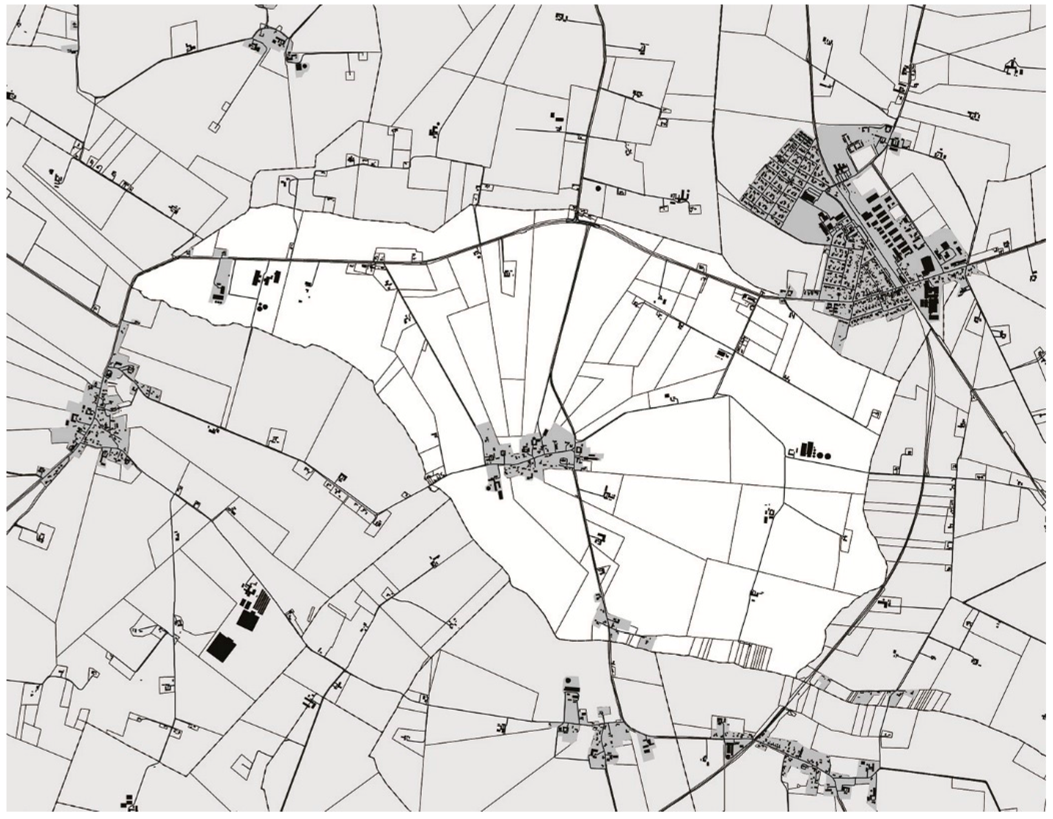
Høve is a village in the Slagelse municipality in southwestern Zealand (Figure 1). The village is organised with houses and farms around an East−West-oriented street (Figure 2). There are two functioning farms, a church and some craftsmen in the town, but apart from that, the village consists of sole housing. The exact number of inhabitants within the village is not assessed by Statistics Denmark which signifies that it is less than 200. The landscape surrounding Høve is covered by a fine mesh of villages, and within a distance of only 5 km, there are as many as eight villages similar to Høve. The municipality of Slagelse comprises more than a hundred villages apart from the three Royal Boroughs of Skelskør, Korsør and Slagelse. The town of Slagelse is 16 km north of Høve and has well over 30,000 inhabitants. It is home to the majority of the political administration [9].
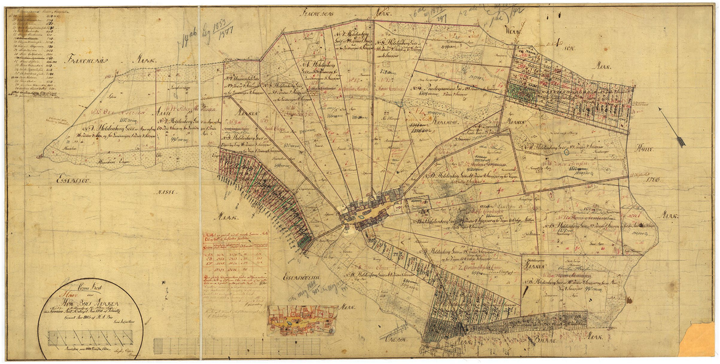
Høve church was built on a hill as one of the earliest in the area around the year 1100 [10]. On the historical map (Figure 3), the church can be seen in the eastern part of the village with the surrounding cemetery. The map is the so-called Original I-map that was created during the rural reforms. This map was valid between 1806 and 1859, which makes it a central source for understanding the development in Høve during this epochal period [11]. The structure of the new fields shows a redistribution that combines the star with the block redistribution. The majority of the land is structured as fields spreading out from the historical village, whereas the most remote fields to the east and the west are divided into blocks. Farms were later erected on the blocks, but the main village structure was kept throughout the rural reforms. The village farms are organised around a village green with the pond in the middle. Comparing this map with the structure today, as shown in Figure 2, illustrates the effect of partitioning following the decentralisation of ownership that happened primarily during the first half of the 19th century. At the height of the cooperative period, Høve included societal institutions such as a post office and a primary school, service functions such as a grocery store, craftsmen and a handful of farms. The closure of societal institutions and service functions corresponded with societal centralisation during the second half of the 20th century.
Looking at the overall trends for rural districts in the Slagelse municipality during the last ten years, there is a decline in the number of inhabitants. The overall number of inhabitants in the municipality is rising slightly and the three main towns have experienced a moderate increase in their population. The actual movements cannot be deduced from the statistics, but what can be stated is that there is a concentration of inhabitants in the municipality in the largest towns. The statistics confirm the picture of a centralisation of the population, but the migration in the specific site of the Slagelse municipality is not significant [12]. Figure 4 shows a selection of motifs from the village as it appears today.
Relating the history of Høve to the description of the generic Danish village from Porsmose points towards a range of important historical buildings and structures. The church is the primary monumental object that defines the foundation of the village. On a large scale, the distribution of the fields as a star around the village clarifies how the redistribution was conducted during the rural reforms. The four-wing farms were the dominating typology of settlement during the vast majority of the village’s history. Of these, only very few exist today, conveying a frame for the understanding of earlier ways of living. The cooperative period has not left monumental school buildings or dairies like in many other villages, as these institutions were organised in collaboration with the neighbouring villages and placed outside of Høve. The profound changes to farming since the second half of the 19th century is however evident in the perception of the village today.
2.1. Project Descriptions
The following descriptions and analysis focus on aspects of the student research projects, which are particularly interesting in their historical analysis. The quotations are translated extracts of the student’s descriptions of their projects, which was is published in the journal, By og Land.
2.1.1. Project A
Project A critiques the relation between “nature” and “culture” in the village and aims to “balance” the relationship between settlement and agricultural production: “By examining the components of the Danish cultural landscape the basis for the project is clarified to balance and strengthen the relation between agricultural production and settlement in the village” [13]. Figure 5 is a representation of components that are considered significant.
The project suggests demolition of an empty and decaying historic farm in the centre of the village and replaces it with a new production unit for an apple orchard (Figure 6). The orchard encompasses two buildings: “To the north is the actual production building, a 90-meter long wing, that is oriented towards the production landscape. The building is organized after a pragmatic and linear scheme with picking, processing and storing” [13]. Across the road is a visitor’s centre. Figure 7 and Figure 8 show the design of the new production unit.
The choice of an apple orchard is based on an historical fact: “The establishment of an apple orchard seems obvious as Høve appears to host a distinctive apple called the ‘Høve Reinette,’ a particular apple type whose mother tree is said to have been planted from a pit around 1874. . . “The orchard is to function as a cooperative. The members have ownership of the orchard, which on a daily basis is operated by fruit growers on behalf of the cooperative” [13].
The fields of the orchard are organised in order to enhance the historical star-distribution around the village (Figure 6). Along the plantation, pathways give opportunities for walks in the landscape:
“The establishment of an apple orchard contains a stance on the village as type of settlement. The apple orchard obtains a significant role as an identity-giving and site-specific element in the village. Høve will once again form a place for the production of a specialized agriculture and simultaneously be an attractive recreational settlement area with a locally anchored community in a common ownership” [13].
2.1.2. Project B
Project B emphasises the lack of relationship between the village and the surroundings and suggests pathways in the field boundaries (Figure 9). Public spaces are established in the village and the project works in detail with the borders and thresholds between public and private (Figure 10): “This happens through characteristic elements as chip stone pavement, earth banks and traditional planting such as hornbeam, wild cherry, field maple, hazel, rowan, elder, thorn and lilac” [14].
The compound typological as well as material character of the village is enhanced through the analysis, and the four-wing farm is emphasised as an important culture-bearing typology.
“Fragmentation reigns in the building stock of Høve, where a consistent feature at close to all existing farms and single family houses is a rational processing of the building material and where an adaption to new functions has had an apparent mark in the townscape. This is expressed through meeting of materials where thatched roofs, timber framing and chip stone is mixing with fibre-cemented board, double-glazed windows, light concrete elements and where lime and linseed oil predominantly have been replaced with cement and plastic paint. Høve is witness to the development of the rural reforms and its influence on the village structure and the motifs of modern farming has inscribed itself on the village and dominates equivalent to the historical farms and the modern parcel houses in the townscape” [14].
The four-wing farm is however considered a particularly significant typology. “The four-wing farms as typology is an important part of the culture-bearing building stock that with its simple logic, quietness, and materials has inherent historical qualities that recount for and point back on the life that has taken place during time” [14]. Based on that position, the farm that Project A suggested be demolished is, in Project B, recommended for restoration.
The student describes the building as “…an empty four-wing farm from the 18th century at around 500m2, which is centrally placed in Høve, to the west by the village pond. The farm is in a critical condition after many years of dereliction and its authenticity has been weakened by numerous devastating repairs and modifications. Even though the farm appears violated and unoriginal it carries as typology the history of the village and through this reminiscence it constitutes a continuity that links the past to the present and the future” [14].
Of the existing four wings, two are restored (Figure 11) while two are in such bad condition and so “unoriginal” that they are reconstructed as new wings. “The new masonry is subordinate to the rhythm and aesthetics of the timber-frame structure but is clearly new” [14], the description states.
Figure 12 shows the windows in the restored and the reconstructed wings respectively. The farm is suggested to contain an office community.
2.1.3. Project C
Project C [15] focuses on the relationship between buildings in the village and criticises the lack of public space. “The asphalted road with through traffic is apart from the table and bench by the pond, the villages’ only public space” [15]. “From the public spaces it is barely possible to see the houses of the village—and entirely impossible to see the surrounding landscape. The village is so overgrown that trees and shrubs are actually the most dominating characteristic” [15].
The project finds inspiration in a map from 1862, where the farms surround the green with the vegetable gardens behind them (Figure 13): “Høve was originally a Green-village meaning a village built around a common centre, the Green. Here the animals of the village were grazing, safe and under the supervision of everyone. . . What physically defined the village was a cluster of houses, a church, a pond and the surrounding fields, the villages’ livelihood. Particularly important for the life of the village was the physical and visual contact” [15].
As shown on Figure 2, this former organisation is no longer apparent: “Recently the diagram of the village has been disturbed by newcomers who have built houses on the former Green. The clear diagram has not been read or honoured in the last 100 years . . . A severe privatisation of the public space of the village. The most recent—and unfortunately generally least village-suited houses—is now placed in the middle of the village, that used to be a space for the community. The new plan allows a very wide village, where the most beautiful houses are the least visible” [15].
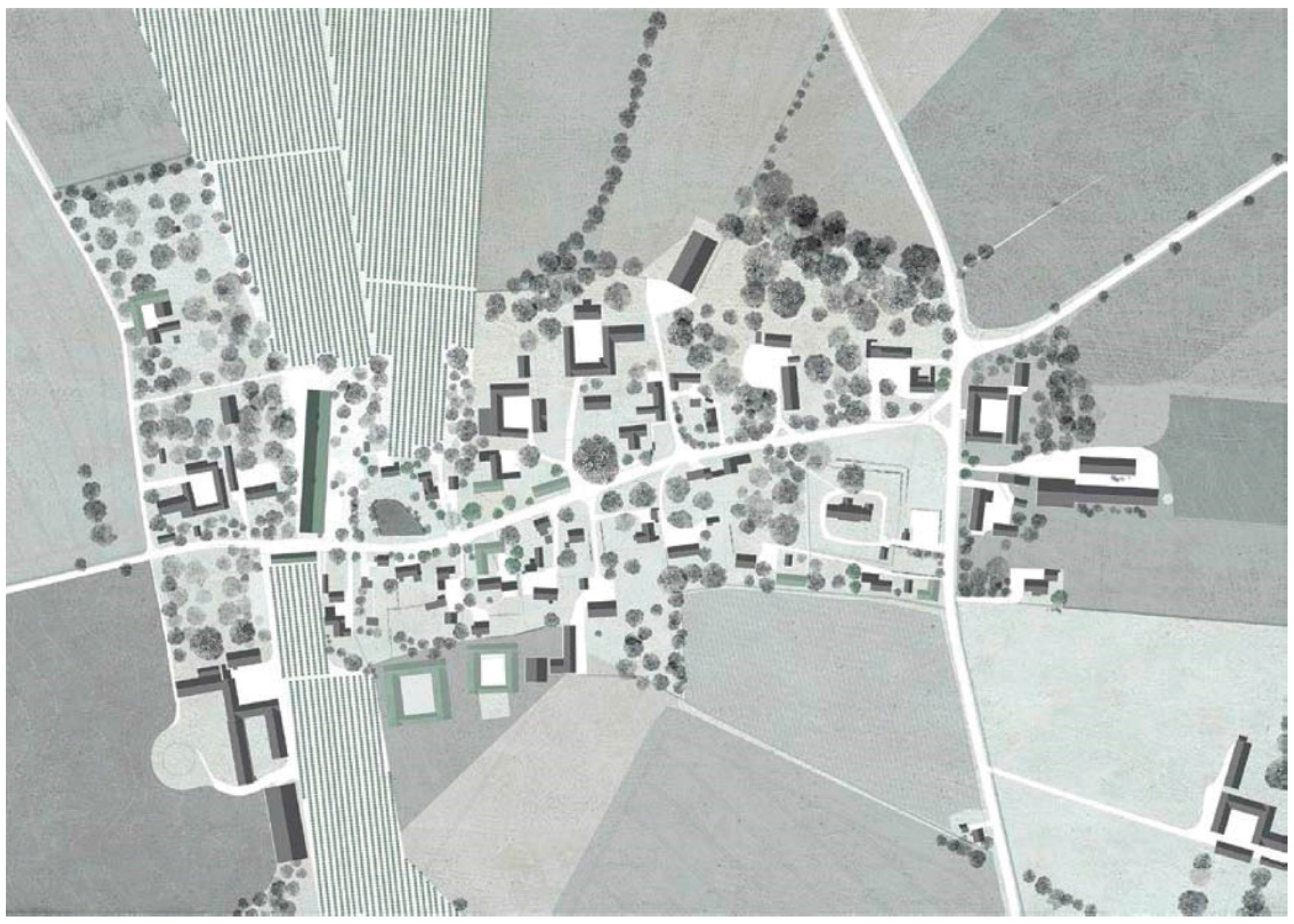
The project suggested a reestablishment of a green centrally in the village (Figure 14): “The urban plan of Høve is recreated by drawing a line along the outermost buildings. The cadastres are relocated so that they reach out from the back of the houses and the façade becomes threshold to the Green . . . 202 trees on the Green were cut down and the visibility in the village had increased remarkably. Between the houses of the outer edge, 28 stone fences were built, which tighten up the edge and prevent animals from possibly leaving the Green” [15]. The existing houses that have been erected on the subdivided green are initially kept as “islands,” but over time it is suggested they be removed: “As the houses within the Green are vacated and dilapidated, the original plan of Høve is restored. New buildings should be built on the edge to the Green and the stone wall acts as enclosure until the hole to the fields is closed by a new house” [15].
Even though the description explains a reestablishment of the original green, it is obvious that the new green is not shaped after the former, but by the buildings existing in Høve today: “It is important here to underline that the former plan is not recreated because the village used to be organised like that—but because there was a purpose with such organisation. With the project, I have allowed a frank approach to the architectural history and picked what I found to have a justification in a modern society” [15].
The projects aim at creating a specific identity for Høve, due to the distinct masterplan. It turns the development towards isolation of the dwellings into a more coherent village (Figure 15): “I hope that a project like this one could change the identity of Høve and make the village something special. It will be a movement away from the continuous isolation of the individual in the village and pull the inhabitants away from their cars and screens and out in the local area” [15].
2.2. Analysis
2.2.1. Project A
Project A exemplifies a contemporary focus on the interrelation between tangible and intangible elements of cultural heritage. The initial analysis presents fundamentally different existing physical structures as a joint layering (Figure 5) and suggests a distinct pragmatism in the assessment of importance of the structures. It eradicates the influence of the elements on the cultural development in order to simply regard them for their influence on the visual interpretation of the cultural landscape. The most consistent logic behind the elements is the plain utilisation of the landscape. An intangible logic leading to a range of tangible objects. The relation of the settlement to this important logic is imperceptible in the settlement of the village today. It is this crucial relation that the project aims at recreating.
The project illustrates this intention in a strong way by demolishing the historical farm, that while centrally located in the village, has lost its original purpose. Its function has changed into being primarily a sentimental reminder of the past. However, because the farm is not capable of showing its relevance, it is eventually left behind for deterioration. Instead, a farm suitable for modern production must take its place and re-establish the village as basis for the cultivation of land. The architecture is similarly unsentimental, insisting that the new farm must have the same pragmatic approach to contemporary construction methods as the former one had when it was built (Figure 8).
The positioning of the production unit centrally in the village breaks with a long tendency. First, the production was moved to the periphery of the village and was later relocated from the village completely to new positions in the open land. This break is interesting for two reasons. It works against a general spatial dilution forced by the relocation of the production buildings and enhanced by depopulation and demolition of houses that affect many Danish villages today. Further, the proposal works against a change from pragmatic production-adapted infrastructure towards a residentially based solution, thereby maintaining an atmosphere characterised by farming and avoiding one that is characteristic of suburbia.
In the description, the project depicts a range of terms and arguments that positions its conceptualisation of history. Initially the project states a need to “… balance and strengthen the relationship between agricultural production and settlement in the village” [13]. The need for such balance is the dominating historical perspective in the project and the underlying analysis that defines it. It offers a “new heritage” discourse, and it is interesting that the primary matter of preservation is not the objects that communicate elements of the past, but a relationship that is as present today as it has been in the past and which will also be in the future. In a sense, the historical analysis is not conducted to create a hierarchy in the importance of the handed-down structures, but to find an underlying logic behind it. A kind of essentialism, which is confirmed by the fact that “…an apple orchard seems obvious…” [13] because there once was a local sort. There is a destiny derived from some characteristics of the place, which should be the basis for the settlement. From this perspective, the project does not correspond to new heritage, where the wishes of the contemporary inhabitants would, to a greater extent, define the qualities that should be emphasised. That might as well have been the picturesque views in the village or the quietness due to farms vanishing from the locality. One result of the analysis is the idea of “pragmatism” in the assessment of viability of the buildings, which results in the demolishing of an historical farm.
Another aspect, which has not been described as an historical reference, but might as well have been, is the cooperative organisation of the orchard. Going back in history, the latest blossoming of the villages was during the cooperative movement which took place during the latest half of the 19th and first half of the 20th century. Furthermore, an extensive cooperative production characterised the villages between the foundation of the villages until the rural reforms. In that light, the sense of community and common interests is as defining for the village settlement as the utilisation of the land. Even though it is not emphasised in the description, this aspect of Project A suggests a critical element that could potentially become a perspective in a heritage assessment.
The project’s focus on the star-redistribution challenges the consistency of “pragmatism,” as the continuous amalgamation of fields in the contemporary development of farming would probably suggest other structures for the future. Also, the phrase that “Høve will once again form a place for production of a specialized agriculture…” [13] suggests a more romanticised image of the past than would be expected when considering the architecture of the production unit.
2.2.2. Project B
Project B’s description suggests that the perception of the village today emphasises its compound character and historical layering. It suggests that it possesses “a rational processing of the building material and where an adaption to new functions has had an apparent mark in the townscape” [14]. Furthermore, that “…the motifs of modern farming have been inscribed on the village and dominates equivalent to the historical farms and the modern parcel houses in the townscape” [14]. But instead of considering these characteristics as a quality, it seems like the project bemoans these features. At least, the specific four-wing farm, which “is in a critical condition after many years of dereliction” [14] should by all means be preserved—even rebuilt—in order to maintain it as a typology within the village. This choice indicates an approach to history that has a significant focus on the physical structures of the past. Project B argues that “devastating repairs” [14] have been carried out at the farm, where “lime and linseed oil have predominantly been replaced with cement and plastic paint” [14]. It claims that this has resulted in a “weakening” of the building’s “authenticity.” These traditional typologies, building techniques and materials are considered a significant matter of heritage.
It is worth noting the use of the word ‘”authenticity” that is said to be “weakened.” According to Smith, this use reflects an interesting change of the concept. While it used to be a strict description of matter from the erection of, for example, a building, today the term covers some kind of atmosphere. The new use places a much greater responsibility with the architect, as the assessment of whether something is “authentic” or not is no longer based on a technical analysis, but on an interpretation [7] (p. 40–41).
Even though Project B conducts a very thorough technical analysis on the existing structures (Figure 11), the project does not deviate from a high level of interpretation. That is stressed by the example of the windows (Figure 12).
What are considered the original windows of the farm are no longer present, so the project very convincingly reconstructs an “original” window (Figure 12a). The basis for the reconstruction is the parts of windows considered original, which were found at the site in addition to studies of the geometry of windows in Danish 18th-century farm buildings. The result is consistently loyal to the studies, leading to single-layer cylinder-glass in thin frames treated with linseed oil paint. The critical aspect of this strategy is the risk of recreating a past that might not ever have existed. The reconstruction might miss and exclude untypical and surprising solutions that have existed at this exact farm. Further, the reconstruction eradicates the interesting story that someone at some time has found these original windows insufficient for this purpose, leading to their renewal. Such choices might be considered to be wrong, but are they not interesting from a heritage perspective?
Figure 12b shows a completely different approach. The logic here seems to be that the reconstructed wings should not try to imitate the former structures, but instead find inspiration in them for the geometry and choice of material. That logic is confirmed in the description of the masonry in the new wings: “The new masonry is subordinate to the rhythm and aesthetics of the timber-frame structure but is clearly new” [14]. The same logic seems to apply to the new window (Figure 12b), which repeats the format from the windows in the restored wings, but without the sash bars, which could be considered to give them a more contemporary look and avoid the danger of mere imitation.
The very different approaches in the two windows indicate a delicate judgement in the allowed level of architectural ingenuity. It effectively exhibits a continuous reflection on the limit between restoration and replica. The urge to explicitly describe the new masonry as “clearly new” shows that such a limit does exist.
The same negotiations between replica and inspiration are present in Project B’s intervention with the borders and thresholds of the village (Figure 10). To some extent, it seems like these types are suggested as mere reconstructions of historical elements. However, the drawings show contemporary technical solutions of draining and structural stability hidden underground. This dichotomy between the visible elements as historical and the hidden ones as modern gives the project a strange mistrust in the actual performance of the historical solutions. They might only be interesting as an abstract image. Here the level of fiction leaves the above-mentioned “delicate judgement” behind and enters a radical approach in the search of an historical village atmosphere. At this specific point, Project B makes reference to the most radical examples of New Urbanism that could be exemplified with the castles built at Haverleij in the Netherlands during the 1990s [16] or to Jakriborg in southern Sweden [17].
It is probable that such an historical atmosphere appeals to a significant part of the Danish population and there are numerous examples of villages whose identity is fundamentally built upon their historical narrative. One question that occurs here is whether this strategy is applicable at a larger scale to the general state of the Danish village. Moreover, if not, would Høve—with its historically compound character—then be the village where this strategy would have the largest potential?
2.2.3. Project C
Project C departs in a spatial critique of Høve as it appears today where “…trees and shrubs are actually the most dominating characteristic” [15]. The consequence of this is considered to be a contribution to a more individualised settlement, where each house is not visible from the road and the only potential interaction is by car. Therefore, the critique is broader than a mere spatial one, as it is considered to influence the social character of the settlement.
The former layout of the village found on the map from 1862 (Figure 13) is used in Project C as an inspiration for a new scheme for the village. Project C asserts that “particularly important for the life of the village was the physical and visual contact” [15]. The loss of these qualities are thereby considered a cause of the spatial problems apparent today and likewise to the lack of social cohesion.
By restructuring the cadastres and moving the private gardens to the back of the houses, a new green emerges. The green is, to a large extent, released from trees and bushes and is fringed by stone walls. Further, the plan (Figure 14) shows that the road is moved to the edge of the green. At all these levels, Project C is directly influenced by characteristics traced in the history of the site. However, even though the description tells about the plan being “recreated” and that “the original plan of Høve is restored” [15], it is evident that the new plan is actually not a recreation of the old one. Instead, it is based on the building structures present in Høve today and actually does not look very much like the shape of the former.
This point is interesting in understanding the projects’ conceptualisation of history. Instead of restoring the green as an historical fact, it is primarily restored due to an analysis of its spatial qualities. The project uses the idea of the green as a central public space for the village. With the new layout, the buildings reoccur in the townscape as the main element forming the village. The approach reveals a relation to history that is more utilitarian of the historical knowledge than humble to the actual past. It suggests to leaf through the pages of history in order to search for inspiration or actual concepts that are suitable for contributing to a contemporary problem. Yet it is somehow respectful in the fact that it actually turns to the history of the specific site to find the right solutions. It could be argued that the traditional ways of settling a landscape like this one contain knowledge that lasts throughout time and the massive changes that apply to the settlement.
The initial critique also refers to a change in the concept of planning. The description of the project states that former planning was carried out by the priest or the teacher in the village. According to Porsmose, it was a change in ownership from the landlord to the individual that caused the significant partitioning of the green. Today, it is a much more complex and lengthy process to conduct changes to the overall structure of a village like this one. Public institutions at municipal, regional, national and European levels handle the planning. In that light, the proposal would probably require absolute consensus in order to have any chance of realisation. Project C reveals an interesting perspective on an approach to history which is a merely utilitarian one. It proposes a way to lift the perspective above the messy reality.
3. Discussion
In an effort to elucidate new approaches to the use of history in village development, the students were asked to conduct their own study and analysis as basis for their proposal. Comparing the three projects stresses the particularity of each of them. Project A finds the relation to farming and the social interdependency in the village a matter of preservation and a tool for revitalising it. Project B finds the historical typologies, building culture and traditional materials and planting an important feature. Project C emphasises the spatial conditions for organising a community within a landscape, an aspect of history that could ameliorate the local circumstances. On the whole, it is a rather broad range of conceptions on the use of history. This discussion considers the projects in relation to a critique that has been applied to former translations of history into heritage and the possible identities this translation has favoured. Further, it wishes to position the projects in relation to the old and new heritage discourses described by Fairclough.
So, do the projects accentuate a particular national agenda like the heritage institutions have been accused of? The trajectory through the Danish village history presented on behalf of Porsmose can serve as anexponent for such a coherent national narrative and a comparison with this can help answer the question. Even though there are significant differences in approach, none of the projects challenges either the monumentality of the church, nor the field structure from the star-redistribution. Conversely, they all emphasise the qualities of the field structure and in different ways emphasise these components spatially. The comprehension of the rural settlement as a farming community, the valuation of the four-wing farm and the accentuated qualities of the structure around the green are also all elements that support this narrative. In that light, it seems that even within the national narrative, the range of possible interventions is relatively broad.
Do they convey a problematically narrow space for different identities to feel at home and represented in the narratives being shaped? Such a critique might to some extent be recognised in all three projects, as their conceptualisations point to a quite distinct agenda; respectively apple-farming (Project A), historical structures (Project B) and unified community (Project C). In all three projects, the fragmented character at all levels of the settlement today is aimed towards a more coherent narrative for the village. However, instead of perceiving this as an effect of the historical focus, this might as well be a tendency of distinct narration in the architectural profession in general and probably a feature we will have to reflect upon more critically.
A fundamental distinction between the old and the new heritage discourse is the attitude towards whom the preservation serves. All the projects consider their own approach a way of increasing the qualities and potentials for the village today and into the future. The value of history is assessed on what it can contribute to the present. None of the projects considers the preservation is legitimising itself as Fairclough claims the old heritage would, but argues what it is good for. The approach to history might even be called utilitarian. This approach is, however, only a feature in the new heritage. Smith as well as Ashworth argue that heritage has always been used to promote certain identities and for capitalising on heritage tourism. In that light, the use of historical references in order to promote the qualities of the life in the village is a rather traditional approach.
Most evident in the description of Project A and Project B is a tendency to use history to justify the response. In other words, repetition of the past exonerates one from responsibility in the design choices. However, comparing the result of the projects clarifies that the historical references to no extent objectifies the choices. The different results show that individual choices are made among the infinite elements of the past and these define the character of the proposal. References to historical facts are most likely a convenient and also productive grounding and inspiration when searching for directions in the design process.
The actual matters of heritage in the description of New Heritage by Fairclough is open-ended to the extent of obscurity. With the less “professionalised” and more “democratised” heritage assessment such as participatory processes as an essential aim of the new heritage discourse, general guidelines for matters of heritage probably will not exist like they do in the heritage institutions today. The matters of heritage will most likely be much more disintegrated and dependent on how the assessment is conveyed. Even with this problem in mind I find the breadth of heritage assessment in the three projects extraordinary. The embracing of such diverse aspects of history seems almost baroque in the meaning of punk. Will these diverging conceptions of how history can be translated into heritage and what matters about preservation ever become included in the societal approach? With the indistinct limits of new heritage it is impossible to know how extensive the expansion of the field might become.
As the assignment and the projects were carried out within the frame of the architecture school, an actual realisation of the projects was never intended. Neither was a compliance with planning acts and regulations. On the contrary, the focus was on the development of ideas and concepts and communicating these accurately. However, considering the projects as actual proposals aiming for realisation leads to a discussion of the resilience of the ideas.
As mentioned earlier, each of the projects suggests a strategy that to some extent disregards the compound layering of the existing village and suggests a more distinct concept. If implemented it would be reasonable to suggest that the concepts should be able to exist as parallels. Such a layering might be a welcome mitigation of their approaches. It might on the other hand detach their quality of conceptual acuteness. However, considering a layering of the concepts reveals some of the conflicting interests that they hold. Beginning with Project A, the presence of modern agricultural machinery next to residential housing might cause some conflicts of interest. The historical shift from a situation where all inhabitants of the village were somehow involved or dependent on the agricultural production to the situation today where farming only employs a minority of the inhabitants has indubitably caused a change in the tolerance towards noise and dust from the production. This change might very likely be a central reason for the relocation of the farming units since the 1950s. To convert this process would probably demand a very clear prioritisation from the administrations when conflicts occur, and that would be a major challenge to a contemporary political discourse. Continuing to Project B, the suggested “historical turn” would call for a similarly clear approach from the municipality in conflicts regarding alterations of private houses as well as infrastructural elements. Already it is evident that the approaches in Project A and Project B would run into conflicts. Project C also has its own individual interests in order to implement the idea of re-establishing a central green. It is evident that a layering of the three projects would call for a less conceptual and more flexible approach to the development.
Acknowledging that and looking at the present and recent development, no actual plan seems to have been defining the development. Fundamental societal alterations with basic influence on the needs and qualities of the settlement seems to have been happening without a proactive approach from planning authorities. This seems to be an underlying criticism in the analysis behind all of the three student projects, and the insistence for some directing guides for the development seems to be the most consistent demand in their individual suggestions.
Comparing the drawn projects with the texts describing them indicates a distinction in the approach to the existing village. While the approach of the three drawn projects is rather bold, the descriptions in the articles are more cautious. Where the architectural results of the projects are fundamentally different, the texts provide corresponding analyses of the situation. These distinctions can be due to a number of reasons. First, the initial analysis was—apart from the students’ own registrations—conducted on behalf of existing literature and lectures. This might have given a more traditional analysis than the one the students would have developed themselves. Further, the analysis of significance and prioritisation might change from making a detached analysis to an actual binding project development. This problem ought to be considered in the general discussion of assessment of heritage in these rather generic situations. Finally, the students’ awareness that their articles were directed towards a preservation organisation might have influenced their focus towards a more traditional approach to historical values.
4. Materials and Methods
The article is based on the results of three student projects and the students’ own retrospective descriptions on the historical approach. The following will briefly introduce the process leading to this result.
The semester project at Cultural Heritage, Transformation and Restoration is divided into three phases. The first, Blik, which translates into Look or Gaze, covers four weeks and focuses on analysing the site and selecting an approach for the project. This period is accompanied by a lecture series developed to inform the analysis. The second period, Kast, which translates into Pitch covers seven weeks and is a draft concept for the assignment. The last period, in this case from 19 December 2014 until 30 January 2015 is called Project with the focus of finalising the project. Each phase is finished by a criticism, which involves all students and most of the involved teachers, researchers and guest critics. The critiques are highly prioritised by all involved and functions as a main learning environment.
The arrangement of a series of articles in By og Land was organised after the final criticism, and the projects for publication were chosen by myself and a colleague. The criteria for the selection was the projects’ approach to and use of the historical analysis as instrument for the concept. Further, a group of projects representing very different approaches was pursued. The articles were written by the students, critiqued and adjusted prior to being sent to the journal editor. In all three examples, the editor performed further editing to the text and selection of figures in correspondence with the student and myself.
5. Conclusions
This article enters into a contemporary discussion within the epistemological shift in heritage theory, a shift that has been developed within academia for decades, but is still rather new to heritage institutions and many practitioners within the field. In order to let the theoretical progress influence the management of heritage, a discursive change is required. The article is a contribution to this discursive change. The intention to widen the perspective of matters of heritage in the context of a Danish peripheral village have been pursued using student projects. The outcomes of this work have raised a range of problems that are important to recognise in order to ensure an informed approach to the continual alterations in villages in the Danish outskirts.
A central question of the relationship between tangible and intangible heritage was triggered by Project A. The project underlines the inseparable relation between the two, which has to some extent been acknowledged by parts of an academic environment, but to a lesser extent by practicing professionals in the heritage discipline. In Project B, some central ethical dilemmas in the management of historical material emerged. Dilemmas appeared that relate to the criticism of an alleged Authorised Heritage Discourse, but are more specific to the problems this criticism meets when enrolled in the actual project development in existing physical structures. Project C uses an actual planning concept from the past to pose suggestions to present and future problems. In the three examples, the problems have been lifted out of a sole theoretical domain to be discussed in relation to concrete suggestions for development plans.
Whether the presented architectural projects hold an actual potential to revitalise Høve and turn the depopulation process around is obviously a question without a clear answer. Three quite different approaches each present existing qualities and potentials that could be emphasised in a forthcoming planning process. They show a way to deliver strong narratives, which all contain a clearer identity for the village. This suggests that the most consistent critical analysis throughout the project is the lack of place-based identity in Høve today. A more realisation-oriented study would have to embrace the need for recognising an entire range of identities existing as parallels in the village. A layering of the projects might actually show a more convincing image of the possible potentials of the village, but still with respect to the contained conflicts of interests of such a strategy as reflected upon in the discussion.
The analysed projects clearly show that the conception of history among the students is highly diverse. The possible existence of an AHD within the heritage institutions does not dominate the assessment of historical significance among the students when they are asked to develop projects. However, if considering the drawn project and the written articles separately, the student descriptions show greater affiliation with the AHD than what is presented in the developed projects. This aspect suggests that the students are aware of the existence of such a dominating discourse.
It is noticeable how central the notion of history is for the narratives of the student projects. The diverse approaches further emphasise the importance of keeping an open-minded attitude to what the past is and how it (they) can and should be preserved. The aforementioned split between the analysis and the final projects might suggest an actual abolition of such a division of the process.
Acknowledgments
First of all, I would like to thank Realdania who are co-financing the PhD-project together with The Royal Academy of Fine Arts, Schools of Architecture, Design and Conservation. I would like to thank the organisers of “Regional Urbanism in the Era of Globalisation” at Huddersfield University for an interesting conference, and the editors of this Special Issue of Buildings, Adrian Pitts and Yun Gao, for the invitation to contribute. I would further like to thank the secondary superviser Thomas Juel Clemmensen, for critical comments.
Conflicts of Interest
The author declares no conflict of interest.
References
- Regional-og Landdistriktspolitisk Redegørelse 2016. Available online: http://www.folketingstidende.dk/RIpdf/samling/20151/redegoerelse/R17/20151_R17.pdf (accessed on 31 October 2016).
- Larsen, J.N.; Andersen, H.T.; Haldrup, K.; Hansen, A.R.; Jacobsen, M.H.; Jensen, J.O. Boligmarkedet Uden for de Store Byer: Analyse; Statens Byggeforskningsinstitut: Copenhagen, Denmark, 2014. [Google Scholar]
- Regional-og Landdistriktspolitisk Redegørelse 2014. Available online: http://www.folketingstidende.dk/RIpdf/samling/20131/redegoerelse/R13/20131_R13.pdf (accessed on 31 October 2016).
- Stop Udsalget af det åbne Danske Landskab. Available online: http://politiken.dk/debat/kroniken/ece3042484/stop-udsalget-af-det-aabne-danske-landskab/ (accessed on 20 October 2016).
- Porsmose, E. Danske Landsbyer; Gyldendal: Copenhagen, Denmark, 2008. [Google Scholar]
- Ashworth, G. From history to Heritage—From Heritage to Identity. In Building a New Heritage; Ashworth, G., Larkham, P.J., Eds.; Routledge: London, UK, 1994. [Google Scholar]
- Smith, L. Uses of Heritage; Routledge: New York, NY, USA, 2006. [Google Scholar]
- Fairclough, G. New Heritage Frontiers. In Heritage and Beyond; Therond, D., Ed.; Council of Europe Publishing: Strasbourg, France, 2009. [Google Scholar]
- Slagelse Kommuneplan 2009–2020 Hovedstruktur. Available online: http://slagelse-kp09.cowi.webhouse.dk/download/endelig_kommuneplan_2009/kommuneplan_2009_2020_hovedstruktur.pdf (accessed on 31 October 2016).
- Høve Kirke. Available online: http://denstoredanske.dk/Kunst_og_kultur/Arkitektur/Danske_kirker_H-H%C3%A5/H%C3%B8ve_Kirke (accessed on 21 October 2016).
- Historiske Kort på Nettet. Available online: http://hkpn.gst.dk/ (accessed on 21 October 2016).
- Danmarks Statistik Table BEF44. Available online: http://www.statistikbanken.dk/BEF44 (accessed on 27 June 2016).
- Bak, S.N. Kan en æbleplatage sikre Høves overlevelse som landsby? By og Land 2015, 108, 22–25. [Google Scholar]
- Drachmann, A. Landsbyens fremtid—Udvikling gennem bevaring. By og Land 2016, 110, 24–27. [Google Scholar]
- Burchardi, M. Landsbyens fremtid—Genetablering af forten. By og Land 2016, 112, 26–29. [Google Scholar]
- Haverleij. Available online: http://www.haverleij.nl/ (accessed on 25 October 2016).
- Jakriborg. Available online: http://www.jakriborg.se/ (accessed on 25 October 2016).
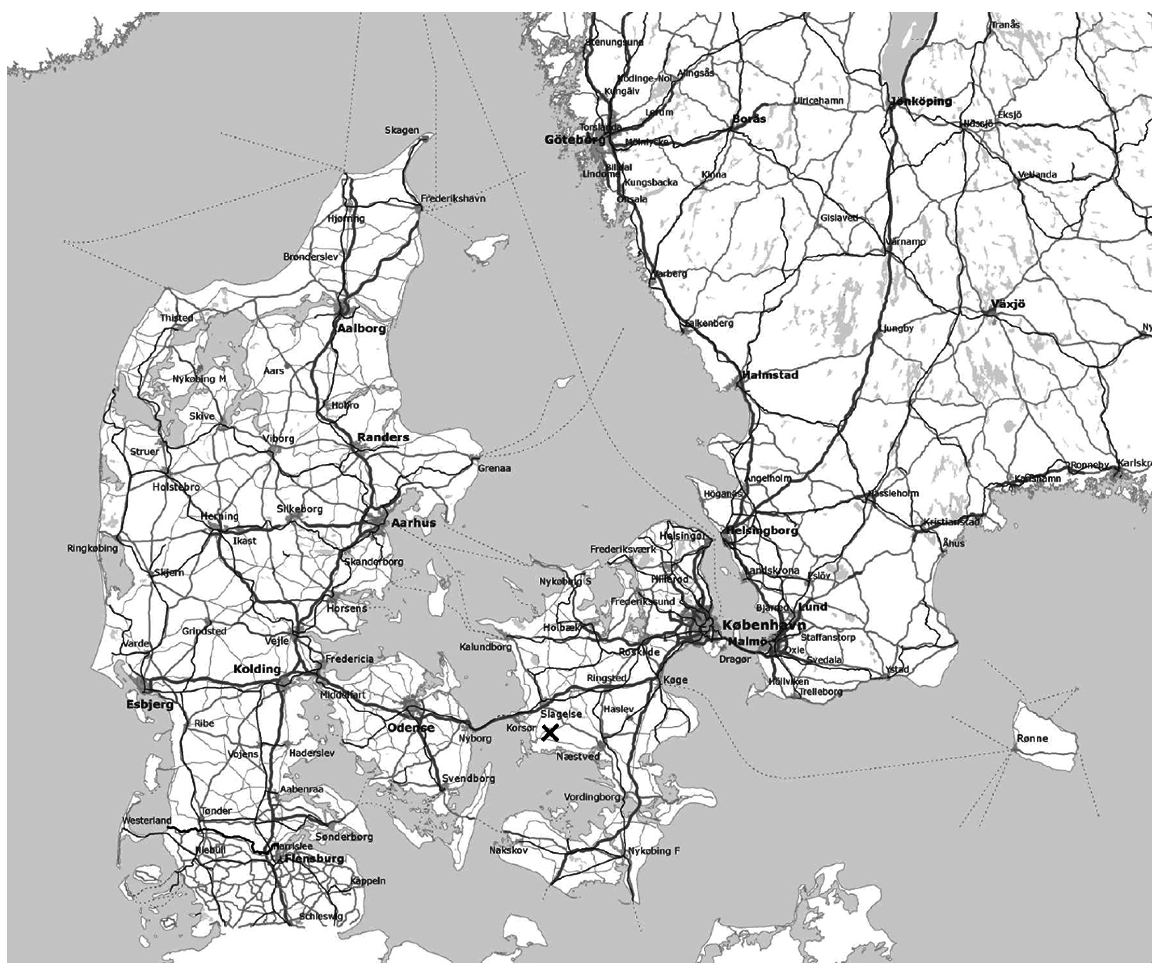
Figure 1.
Map of Denmark and South Eastern Sweden. The X indicates the position of Høve.

Figure 2.
Map of Høve. The white area indicates the area of land belonging to the village. The village northwest of Høve is Dalmose, which grew as an effect of a former train station. The retail store and public school closest to Høve is situated in Dalmose.
Figure 2.
Map of Høve. The white area indicates the area of land belonging to the village. The village northwest of Høve is Dalmose, which grew as an effect of a former train station. The retail store and public school closest to Høve is situated in Dalmose.

Figure 3.
Map from 1806 showing Høve and its surrounding fields shortly after the Redistribution. The church is in the Eastern part of the village with the surrounding cemetery. The village is structured around a central green.
Figure 3.
Map from 1806 showing Høve and its surrounding fields shortly after the Redistribution. The church is in the Eastern part of the village with the surrounding cemetery. The village is structured around a central green.

Figure 4.
Two photographic student entries aiming at capturing the atmosphere of the village.
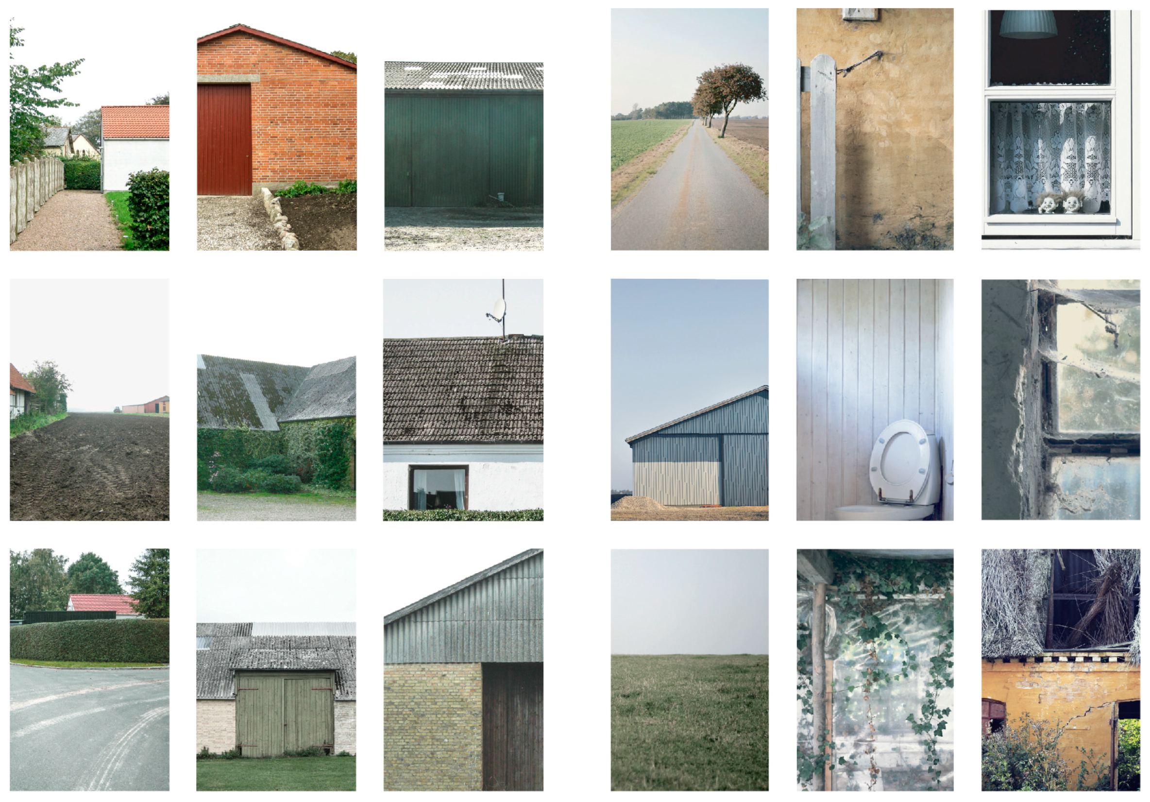
Figure 5.
Analysis of the dominating elements in the cultural landscape. The figure was removed from the article in By og Land, but is presented here as it is considered essential to understanding the project.
Figure 5.
Analysis of the dominating elements in the cultural landscape. The figure was removed from the article in By og Land, but is presented here as it is considered essential to understanding the project.
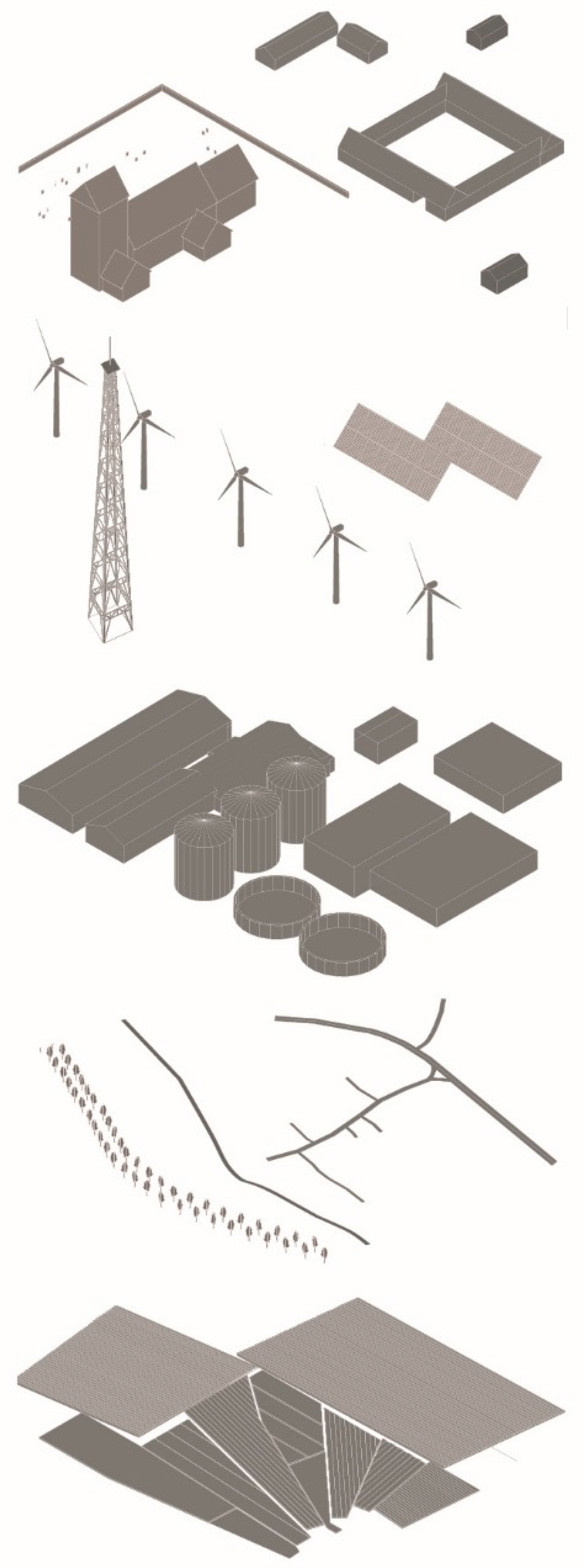
Figure 6.
Plan of Høve with the suggested apple plantation and the production units in the central left part of the figure. The plantation fields spread out to the North and the South of the production unit.
Figure 6.
Plan of Høve with the suggested apple plantation and the production units in the central left part of the figure. The plantation fields spread out to the North and the South of the production unit.

Figure 7.
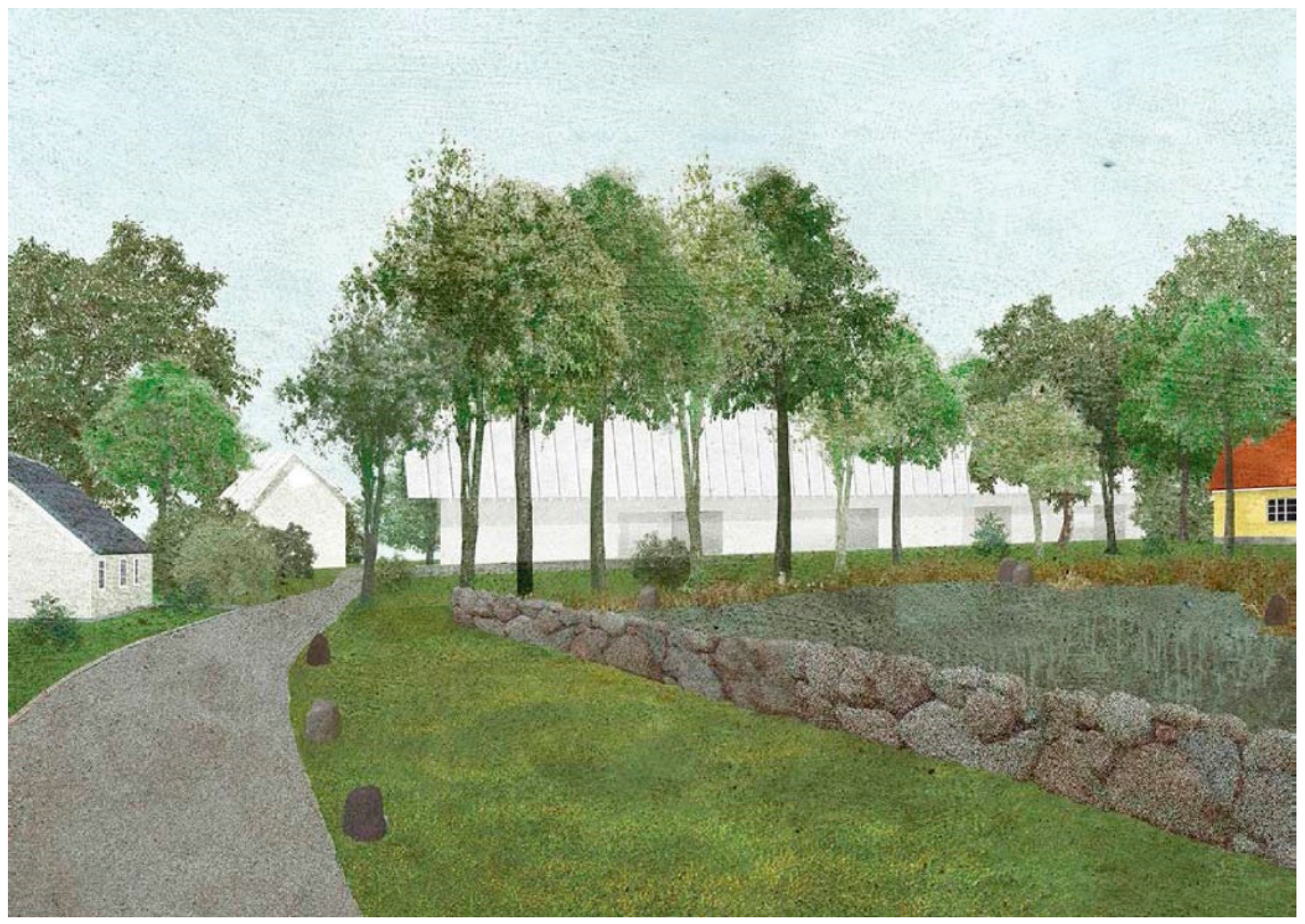
View to the production unit from the main street of Høve with the village pond to the right. The main production unit appears as the large white structure behind the trees. Across the road is the visitor centre and the farm shop.
Figure 7.
View to the production unit from the main street of Høve with the village pond to the right. The main production unit appears as the large white structure behind the trees. Across the road is the visitor centre and the farm shop.

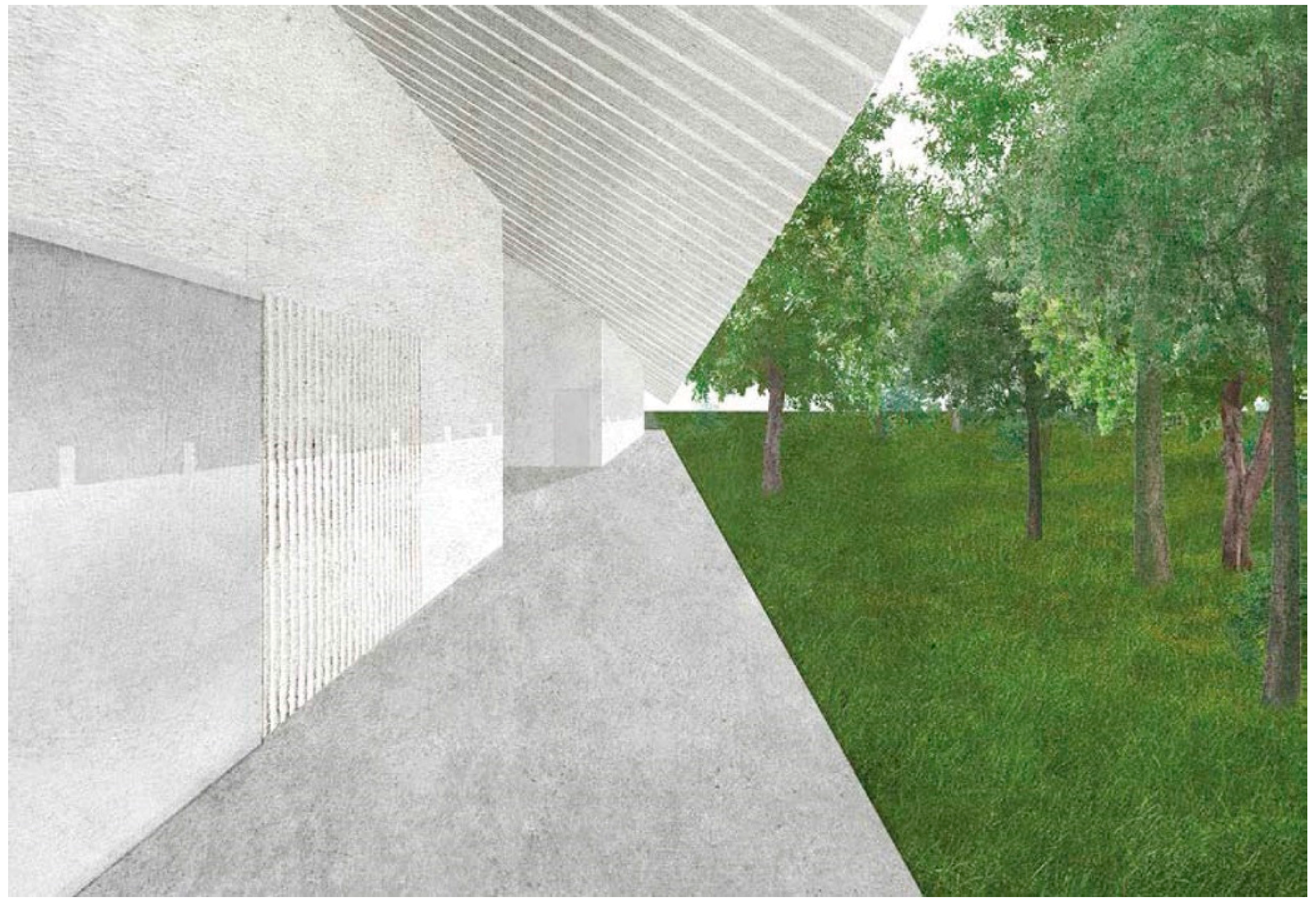
Figure 8.
View along the main production unit.

Figure 9.
Plan of Høve with pathways in the landscape.
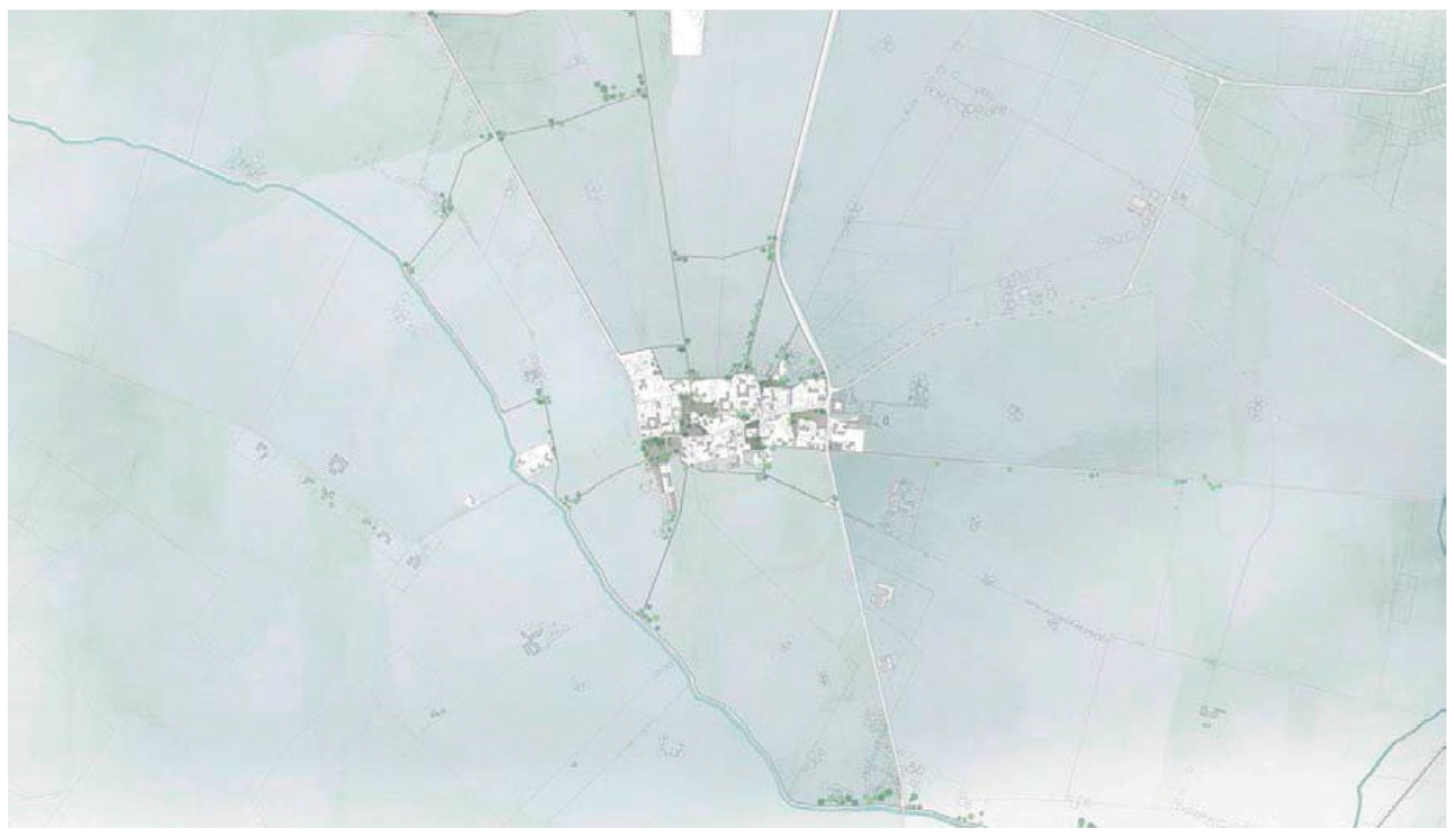
Figure 10.
Suggested borders and thresholds in the village.

Figure 11.
Analysis of usable and non-usable elements in the restored wing of the historical farm building.
Figure 11.
Analysis of usable and non-usable elements in the restored wing of the historical farm building.

Figure 12.
Juxtaposition of new windows in the restored wings (a) and in the reconstructed wings (b).
Figure 12.
Juxtaposition of new windows in the restored wings (a) and in the reconstructed wings (b).
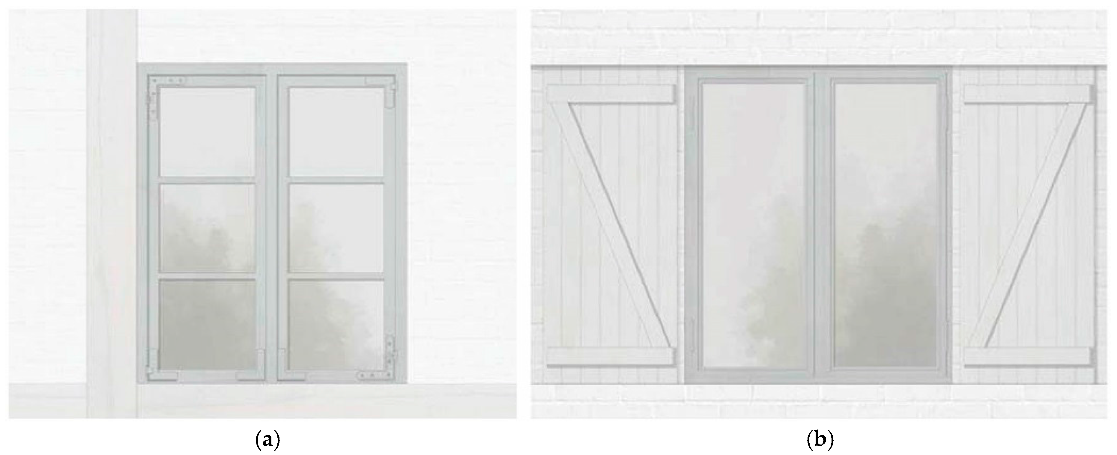
Figure 13.
Section of map from 1862 showing the former organisation of the village.
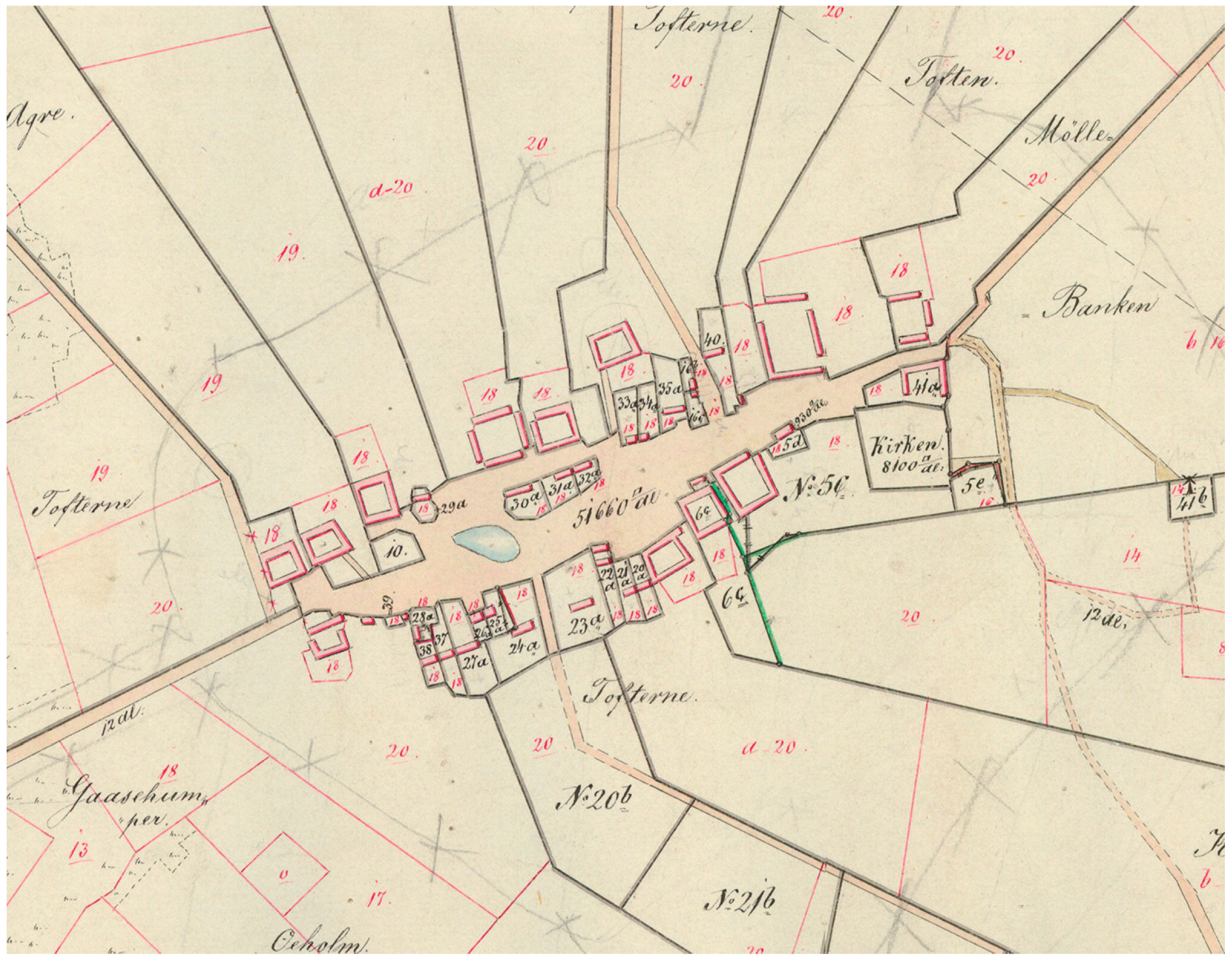
Figure 14.
Suggestion for new plan of Høve.
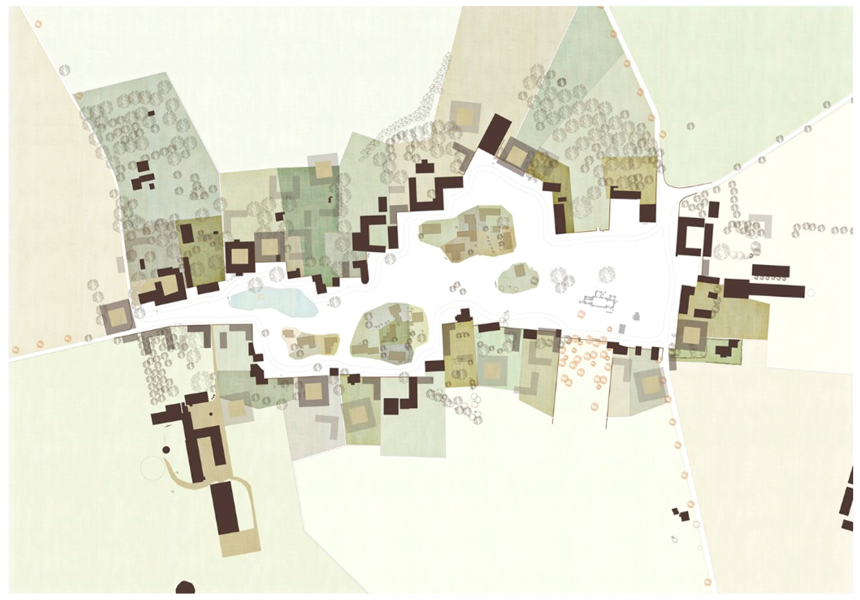
Figure 15.
Visualisation of the re-established green in the centre of the village.
© 2016 by the author; licensee MDPI, Basel, Switzerland. This article is an open access article distributed under the terms and conditions of the Creative Commons Attribution (CC-BY) license (http://creativecommons.org/licenses/by/4.0/).
Share and Cite
MDPI and ACS Style
Jørgensen, M.B. History as an Instrument in the Development of Historical Danish Villages. Buildings 2016, 6, 51. https://doi.org/10.3390/buildings6040051
AMA Style
Jørgensen MB. History as an Instrument in the Development of Historical Danish Villages. Buildings. 2016; 6(4):51. https://doi.org/10.3390/buildings6040051
Chicago/Turabian StyleJørgensen, Morten Birk. 2016. "History as an Instrument in the Development of Historical Danish Villages" Buildings 6, no. 4: 51. https://doi.org/10.3390/buildings6040051
Note that from the first issue of 2016, this journal uses article numbers instead of page numbers. See further details here.