
A Settlers’ Guide: Designing for Resilience in the Hinterlands

1
School of Architecture, University of Technology Sydney, Sydney 2000, Australia
2
School of Architecture, Victoria University of Wellington, Wellington 6011, New Zealand
*
Author to whom correspondence should be addressed.
Buildings 2017, 7(1), 23; https://doi.org/10.3390/buildings7010023
Submission received: 6 February 2017
/
Revised: 6 February 2017
/
Accepted: 28 February 2017
/
Published: 10 March 2017
(This article belongs to the Special Issue Sustainable Building in Rural Areas)
Abstract
:There has often been a mutually beneficial relationship between cities and their rural hinterlands. The Kapiti region outside the city of Wellington in New Zealand is a prime example: it once provided Wellington’s food, water and cultural diversity for both Māori and European settlers. However, productivity-driven agriculture and extensive dormitory-suburbanization have affected significant parts of this once-abundant hinterland. Food production is becoming more mono-cultural, water quality is degrading, ecosystems’ biodiversity is disappearing, provincial town centres are shrinking, emigrating youth are leaving unbalanced demographics, Māori are increasingly disassociating their culture from their traditional lands and natural disasters are causing more impact—all of which is making Kapiti less resilient, and severing the once-healthy city-hinterland relationship. Our work on future settlement opportunities in Kapiti proposes alternatives, using experimental design-led research methods to develop speculative architectural and landscape architectural schemes. The schemes are framed by some of the spatial attributes of resilience: diversity, complexity, redundancy, interconnectivity and adaptability. Collectively, the work reveals design strategies that have a potential to rebuild hinterlands’ culture, town centres, housing, agriculture, community and ecosystems and to recalibrate the broader relationship between hinterlands and metropolitan systems.
Keywords:
resilience; design research; hinterlands; settlement; sweet-spots; scaling up; form-making1. Introduction
High-density centralised well-designed urbanisation is often championed because it offers benefits such as macro-economical power [1], a source of cultural creativity [2], and a capacity for low-carbon emissions [3], and because it promises values such as fairness, safety, accessibility, prosperity, sustainability, and resilience [4].
The flipside of high-density cities is a sparsely occupied hinterland. Hinterlands have room for ecosystem services to replenish clean water and fresh air, and for primary productivity to supply food, energy and materials for hungry cities. Their sparseness promises a healthy diversity of natural ecosystems; their distances promote richly divergent cultures; and their vastness offers space for urban populations to seek adventure, renewal, refuge and reflection. However, these benefits and values are perhaps harder to measure than those of dense city centres, and therefore harder to plan for objectively. Consequently, the vastness and sparseness is increasingly under threat. Subject to intense social, cultural, environmental and economic pressures, the hinterlands’ offer is contingent: city planners see cheap land to expand the city limits; local communities want to protect their culture; resident farmers’ focus is on increasing productivity; and everyone looks worryingly at what climate change might bring. Navigating through this complexity threatens the capacity of a hinterland to offer itself as a complement to the ever-increasing densities of cities.
This research looks at these broad concerns through the specificity of a New Zealand case study. With an abundance of land, water, soil fertility, scenery and biodiversity, the Kapiti–Horowhenua region has the potential to complement the nearby capital city of Wellington. However, recent infrastructure and land use practices such as motorway construction, monocultural agriculture and suburban sprawl have degraded natural resources, diminished local jobs, disaffected Māori culture and, to make matters worse, generated a high vulnerability to natural disasters and climate change effects. The resilience of the place has been weakened, which, in turn, weakens the city-hinterland interdependency. However, it might be better if it is better designed.
The methodology for this research is through design: it entails experiments of architecture and landscape architecture to produce schemes for future settlement. Each scheme explores the ecological, cultural and social systems of this hinterland region through the specificity of building and infrastructural form, urban design and landscape. In doing so, each also looks for a broader scale strategic relationship that suggests a renewed role for the hinterlands. Collectively, the schemes suggest a method of designing for resilience, with both local and regional benefits.
The aim of this collection of design schemes is to gain a deeper understanding of the potential to re-establish a city-hinterland relationship. More specifically, the research asks: What design strategies can strengthen resilience both locally and regionally?
Out of this research, we offer a way of re-thinking future settlement in hinterlands through ‘A Settlers’ Guide’. The etymology of ‘guide’ is the German word gid meaning wit, wit being knowledge [5]. A tourist guide usually provides knowledge about a place based on a selection of very particular highlights and lowlights. It is usually rich and insightful: too much for a tourist to actually take on, but enough to give the sense of what makes up a place, what is possible and what one might choose to avoid. ‘A Settlers’ Guide’ might similarly provide a way of knowing a place through a selection of settlement possibilities that make better sense when they are woven together through design.
1.1. Design Research Methodology
Land-development practices are beginning to recognize the potential of design. The growing availability of geographic, social and cultural data enables developers to look at land, activities and processes at a finer grain than might have been possible in the past. And, with the empowerment of communities in land-based decision-making, developers have a mandate to collaborate with locals.
Design methodologies have the capacity to address both these phenomena [6,7,8]. In the past, institutionalised and centralised broad-scale planning processes have placed emphasis on strategic land uses and relied on real estate subdivision to generate urban diversity through ‘pockets of emptiness’ [9]. Now, data availability provides opportunity to reconceptualise settlement-making through design, with finite local place-specific formal solutions, which test and confront the fine-grained cultural, social and ecological processes of urbanisation [10] and ‘address the complexities of everyday life’ [11]. Furthermore, design’s inherently legible visual language is accessible for many communities, providing accurate projections, rather than a series of strategic flow, analysis or zoning diagrams.
With architecture and landscape architecture Masters students, we have prepared over forty speculative design research schemes in the Kapiti region to explore alternatives to past practices. Kapiti is a good place for experimenting with settlement design through case studies because the economic stakes are low. This removes a significant constraint from the experimentation, and allows designers to focus on the cultural, social and ecological complexities. In the process, the research has uncovered design strategies that address a multitude of issues and that suggest beneficial relationships between settlement form, culture, society and ecological environment. The most interesting schemes, some of which are described below, are those that not only address the local, but also provide a catalyst to realign the network of connections and interdependencies of the Wellington region, and thus strengthen the resilience of the urban-hinterland system.
1.2. Resilience in Spatial Systems
There are two ways of looking at the attributes of resilience [12,13]. One is to recognise globalisation trends and the economies of scale to solve large environmental problems (like climate change) with macro-economic policy-based solutions (like carbon taxes) or large scaled infrastructural solutions, (like building higher levee banks to minimise flooding impacts) [14]. This is an approach to resilience that is protectionist, defensive and machinistic. It relies on fixed one-off purpose-made efficient solutions that contribute to make a system strong enough, predictable enough and constant enough to withstand disturbance [12].
Another approach to transformative change and stronger resilience is, at best, a modest and slow moving process that relies on localised self-organisation [15]. It suggests catalytic projects can build capacity for agility and adaptability in the socio-cultural-environmental system through diversity, redundancies, feedback mechanisms, self-sufficiencies [16], and hierarchies of self-sufficiencies that give interdependency [17]. This way-of-thinking accepts disturbance as inevitable, change as a norm, and outcomes as unpredictable [13,18].
Both ideas of resilience are important. The former is easy to qualify and quantify: policy-making and planning processes are in place to perpetuate that way of thinking and that way of doing. However, the latter may be as important for design, not in denial of the former, but to complement it.
How can design provide a capacity for adaptation, agility and redundancy? One possibility is through design processes that, like resilience, can operate at multiple scales [19]: for example, in the broad scale of a rural or urban system concurrently with the more detailed scale of a house or a garden. Another possibility is that design can address adaptability in a qualitative way by calibrating tensions between competing values, rather than addressing values with absolute or universal criteria [19]. This suggests that resolving the binary oppositions between density and sparseness, or between efficiency and redundancy is less productive, and designing for the interdependency between them is more so.
1.3. Kapiti
Kapiti Horowhenua is a long coastal plain that once supported one of New Zealand’s most significant stretches of wetlands fed by multiple rivers from the Tararua Ranges. In the past, these rivers regularly spread rich alluvial soils across the plain and charged extensive wetlands and aquifers, creating an abundant environment for Māori that settled there in the last 1000 years. Today, there is still a strong Māori presence on the farmlands, at the community settlements and in the school programmes. The abundance has also been enjoyed by European settlement: farming, especially dairy farming, has been highly productive in the rich soils with plentiful water. Settlement in agricultural service towns has been vibrant and prosperous. It has also been important for its nearby major city, Wellington, 50 km to the south. With its deep-watered harbour that facilitates trade and immigration, Wellington is the administrative centre for Kapiti, host of the port and airport for the region, and the location of the region’s largest hospital and universities (Figure 1 and Figure 2).
However, increased settlement and productivity-driven farming in the last 50 years has had some significant environmental, social and cultural impacts. Rivers have been channelised and wetlands reclaimed, and, as a result, the remnant natural ecosystems now lack connectivity and biodiversity. Farmers send their produce directly to the ports and overseas markets, rather than to the local or regional population. The local towns have outlived their servicing role and surrendered their landscape to low-growth dormitory-suburbanization pressures and car-dominated plans. They attract commuters and city refugees to weekend, holiday or retire, mostly because they are searching for a piece of paradise as Wellington gets denser. Detached housing sprawls across land with little regard for existing community values or for the hydrological flows of the region. Meanwhile ecologists seek to conserve biodiversity and reconnect fragmented bushland. And farmers are squeezed, demanding higher yields on less land, which results in the use of more fertilisers and greater stock numbers in the vicinity of fragile water systems. Ironically, in a place once endowed with some of the finest wetlands in the country, water quality is now an issue. However, the issues are not just environmental: youth unemployment, youth emigration and an aging population unbalance the demographic [20]; and Māori are disconcerted by the disassociation between land and culture that this settlement has brought about.
Exacerbating these problems, Kapiti harbours a number of natural hazards. It sits above a major earthquake fault line on threateningly loose soils. Its low-lying topography is vulnerable to future tsunamis and climate-change induced sea-level rise. Rising water tables are causing salination of farming land. Inappropriate overdevelopment increases flooding in low-lying areas and prevents the coastal dunes from operating as they should—as a buffer to the increasingly frequent coastal storms.
The type of settlement and farming has eroded the local benefits of diversity and jeopardised the regional interdependence of Wellington and Kapiti. The following schemes provide a way of looking at possibilities of where settlement might occur in Kapiti, how it might look and how it might work to redress the vulnerabilities, and generate opportunities for the future. We illustrate this through three types of settlement design schemes: in the town centres, in the suburbs and in the farmed rural areas.
2. Speculative Designs
2.1. The Town Centres
In a leftover wetland in Waikanae, one scheme, called Wetland Square [21], responds to the inevitable effects of a new motorway that will divide the existing settlement, and excise one half of the settlement from the current town centre. This scheme proposes an alternative town centre on the leftover half, even though it may seem odd to build a new centre when the existing town centre is waning. What form might this new centre take to reverse the shrinking-town phenomenon? Can it be modest enough and local enough to be of value as a community-generator and town centre with housing opportunities, and still provide links to the environment and the broader region? Wetland Square suggests sitting the centre on the edge of a remnant wetland that currently sits at the back of the backyards, beyond the back fence, as a fenced-off water hazard. The idea is that the wetland with its fluctuating water table should be an essential part of the operation of the community’s public domain.
A pier into the wetland is the starting point: nominally programmed as a market place, it is a spatial device that has a catalysing potential for the amenity of the wetland and the formal possibilities associated with a future town centre (Figure 3). The pier is usual in its rhythmic repetition of posts, but unusual in that its horizontal surfaces tilt down to the water and up at the landward end. These oddities suggest that the architecture can physically link water and land, and ambiguate edges. At the watery end, the inclined plane of the pier appropriates the wetland as a de facto town square, mandating respect and repair for the hydrology, geomorphology, biota and cultural associations of the wetland ecosystem. At the landward end, the upturned pier would intersect with a new built edge that turns its front to the wetlands and provides room for a concentration of economic activity and density of development that a town square warrants. Within walking or cycling distance of the South Waikanae community, the new centre could foster local independence.
At a broader scale, the scheme shows how the watery town square might connect to other proposed ‘wetland squares’ not only through a network of roads, but also through a network of revitalised wetlands that re-establishes what was once the lifeline and identity of this place. With these multiple environmental-based linkages, the scheme could also foster interdependencies for different resources, such as different food, materials or recreation resources across the network.
The scheme reconciles the multiple roles the wetland landscape could have: as a place of beauty, biodiversity, identity, community building, recreation. In particular it proposes a place to start rebuilding the natural ecosystem of contiguous wetlands and provide good-quality water security for future droughts or flooding. Into the future, the rise and fall of the waters will be a compelling indicator of climate change impacts, such as water table imbalances and the effects of increased salination. As the focus of the town centre, it will catalyse the capacity for people to adapt both now and in the future. All of which will make the place more resilient.
The scheme is significant because it shows the potential of overlapping the wetland system with the social structure of a small town centre to encourage communities to make settlement in a way that enables culture as well as natural processes.
‘Shifting Downtown’ [22] is another speculative town centre scheme, but it addresses an existing town centre, rather than a new one.
The current problems in Kapiti’s shrinking town centres are often addressed by superficial makeovers and cheap economic incentives. ‘Renewals’ entail new paving and new street trees to encourage new business. And cheap land at the margins provides room for expansion, even if it entails flattening the landscape, to maximize accessibility to cheap ‘big-box’ retail, which is seen as a panacea to arrest shrinkage. However, the life span of such renewals and expansions will most likely be limited: this type of development is driven by capital, not by the potential to contribute to the social or cultural systems of the place, and it will irreversibly ruin some natural landscapes. Rarely do planners redress prosperity through an infrastructure that recognises the urban fabric’s relationship to broader natural systems.
In an inverted way of thinking, ‘Shifting Downtown’ thinks not of expanding the town, but the reverse: to rebuild the existing town centre by adding dunes and wetlands to the extant street grid. Back dunes and wetlands are important for trapping and storing water, providing protection from winds, harbouring biodiversity and, from a settlement point of view, offering high ground and spatial articulation in an otherwise flattish landscape. The design scheme (Figure 4) proposes laying down a new landform, a series of interconnected dunes and wetlands, over the top of the existing street grid, and declaiming existing built fabric so as to compel development to be more compact. Widened streets with new dunes and deltaic wetlands would accommodate indeterminate street-life/ecological diversity. The smaller building blocks would encourage the urban built form components, which are currently of little value, to self-organise in a density that suits the large block sizes of the original grid, without significantly changing land ownerships.
The design scheme suggests that, rather than trying to shoehorn nature into urban areas, and rather than consuming more natural landscapes, both urban densities and natural ecosystems diversity can work together if given enough room within the large block grid. Scaling up to the regional perspective, the scheme integrates the primacy of natural systems together with effective concentrations of density, both of which support Wellington’s well-being. Thus multiple benefits at multiple scales could accrue from this design, that is framed by resilience thinking.
2.2. The Suburbs
Local employment is a common issue in urban hinterlands, especially for youth, who consequently tend to emigrate to cities and leave an unbalanced demographic. Town centres are usually the locus where urban planners redress this through institutional programmes accommodated in community centres or libraries or schools that foster activities that might unfold into jobs for youth. However, often single-purpose institutional programmes exacerbate the lack of cultural and economic diversity that is needed to make jobs. And, by siting them in town centres, institutional buildings cannot address the lack of diversity in the sprawling suburbs, where built form tends to be housing and the housing tends be so singular in intent and in form that it often eschews other activities and other types of built form that could appeal to creative youth. Can we make institutional built form that could be sited in the suburbs? Could it be designed to address a wide range of possibilities?
In a disused quarry at the foothills of Waikanae’s sprawling detached low-density housing, ‘Plan B-hive’ [23] proposes an educational institution, using an architecture that is inherently indeterminate in function, but precise enough to provide the aesthetic and civic qualities which institutional buildings might offer to bring employment and energy in the suburbs (Figure 5). The design’s flexibility is engineered by a plate girder bridge, which is supported by two large cores that ground the building into the quarry. Beyond each of these cores are base isolating pads that ensure dissipation of seismic loads. Floors float free within the large exoskeleton, creating porous strata within one giant flexible space. The building would offer enough free space and grounds to house any number of educational or youth-based institutions and thereby enhance the demographic profile of the area.
However, the flexibility offers another possibility: to house Parliament (which is colloquially known as the beehive because of its building’s form) and its workers when Wellington city suffers a major earthquake, providing accommodation for Government and its institutions to stay in the region and support any rebuild. The benefit is potentially enormous to the region: most earthquake-affected cities take ten years to recover, and a significant contributor to this protracted time frame is the loss of workforce and industry who move out of the region. To planners, the Parliament option may be seen as an inefficient redundancy. However, in terms of resilience, redundancies like this create healthy overlaps in systems. The overlaps open up a network of possibilities and interdependencies for the region and the local town allowing multiple issues to be addressed at once.
This concept thus addresses the big scale of the city/hinterland region but also addresses the specific problems of the locale. It does this through design that generates a flexible programme within the civic-minded formal precision of architecture.
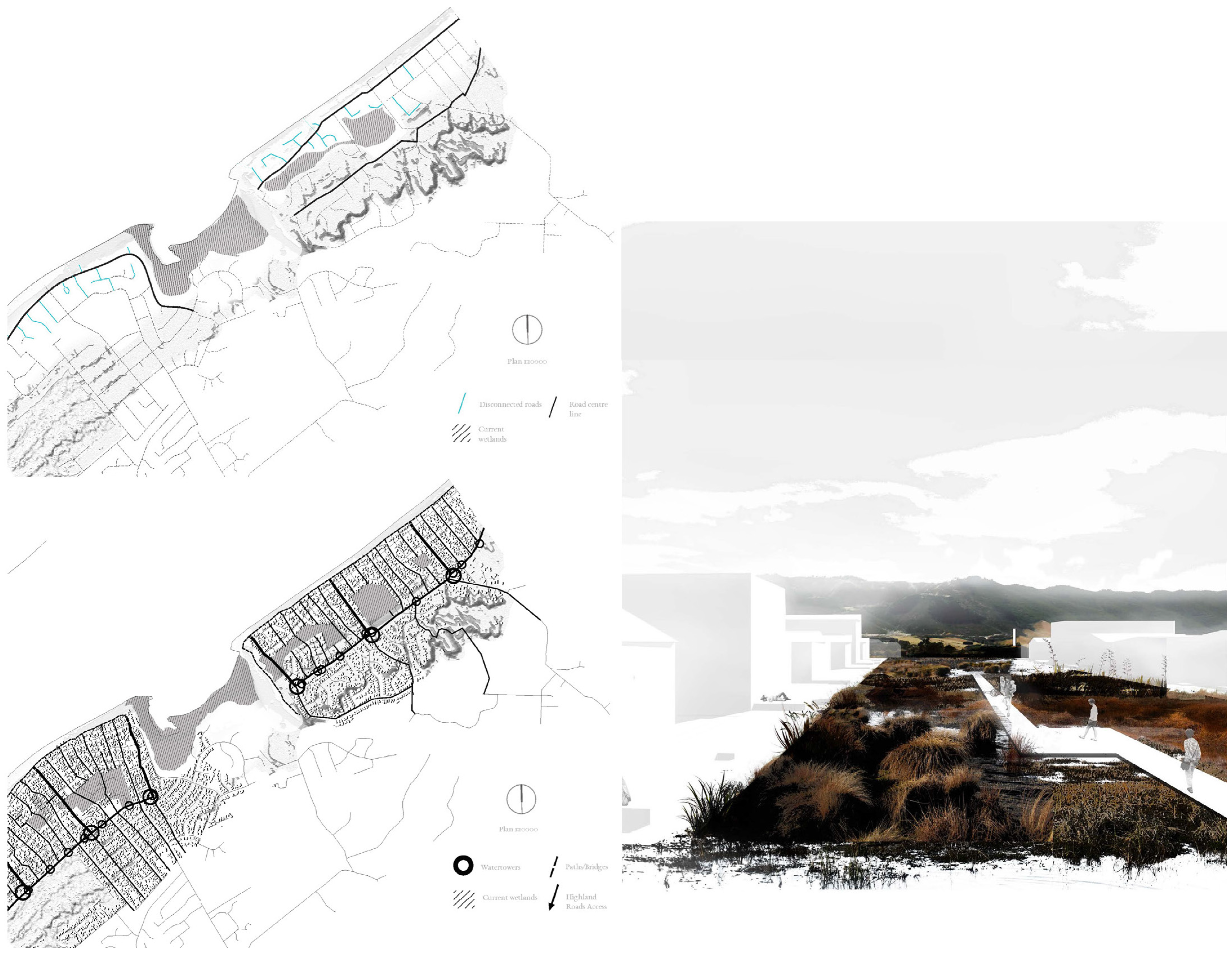
At the other side of Waikanae, beside the sea, another suburban scheme, called High Ground; Low Ground [24] looks at how the existing coastal settlement, which is vulnerable to sea level rise and tsunamis, could retrofit its infrastructure slowly over time, so that it will be physically resilient to future inundation and will encourage social resilience through a stronger community and environmental focus. In this area, the dominant ‘hard’ infrastructure currently runs endlessly parallel to the coast and front dunes. Consequently, the settlement pattern is made up of long rows of individually fenced-off houses, without any centre or hierarchy.
The scheme (Figure 6) entails the introduction of regular paths across the dunes, reorienting movement corridors by 90 degrees to facilitate access from the fore dunes, through the slack dunes with restored wetlands, to the high ground on the back dunes where a cultural focus, with schools, community centres and water towers, will catalyse the establishment of small neighborhood hubs. Infrastructural in scope, this is a modest scheme that the community could undertake slowly, recognizing the potency of small incremental adaptations that maximize impact through community ‘ownership’. Even though it will be transformational, the scheme does not entail the demolition of any of the extant detached houses, nor any increase in built form density in the housing areas, nor any significant adjustments in boundaries. The design process has simply reinterpreted individual houses into assemblages of houses, streets, backyards, dune tops and wetlands. It effectively blurs the ambiguous public/private landscape between houses where environmental, hydrological and social systems have the potential to overlap. This has the potential to improve the everyday recreational facilities of residents, to encourage neighbourliness through street-life and the well-being of the landscape, and to offer a greater sense of self sustainability for the community while providing opportunity for access to high ground, where core facilities can support communities’ everyday activities as well as their need in emergencies. This approach to self-sustainability through small communities that work together will be of major importance when emergencies strike the region.
Importantly, the scheme has the potential to be repeated along the coast, diminishing the role of the endless horizontal parallel coastal roads and instigating a hierarchy of numerous neighbourhoods, each with their own version of perpendicular access lines over the dunes, into the slack dunes, and onto the high ground. Coastal settlements could thus adapt gradually into a series of semi-independent neighbourhoods, each with their own community identity and resources, but also with the potential to be interdependent with other neighbourhoods with different resources along the coast.
2.3. Rural Areas
At present, much of the farming activity in Kapiti is dairy, and, in many cases, the farms are efficient monocultures that maximise economic return, sometimes with little regard for the well-being of the local community or the local environment. Cattle have adverse impacts on the quality of waterways many of which are now highly polluted and losing biodiversity [25]. The lack of diversity is a concern from a long-range economic position, and the loss of biodiversity is a concern for the longevity of the ecosystems. But the regional community is not greatly concerned probably because the farms are largely inaccessible and inconsequential to the town culture.
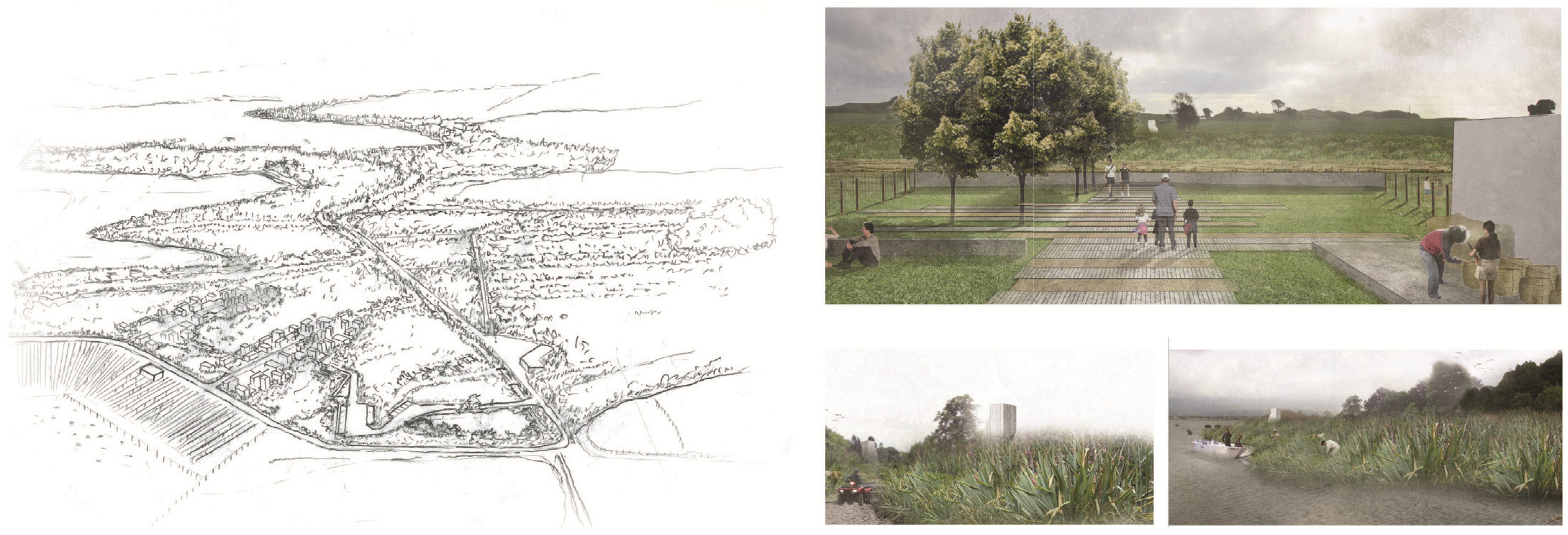
‘Renovating Rural Living’ [26] looks at an existing dairy farm beside the polluted Lake Horowhenua, and the potential for a diversification of the farm activities to improve water quality, protect the waterways and encourage the local community to settle on small parts of the farm, and thus generate a connection between community, landscape and production without ever compromising agricultural yield. The hypothesis is that community use of farmland could generate a greater synergy and respect between farmers, the local towns people, and people in the city.
The scheme (Figure 7) shows the reconfiguration of paddocks for the introduction of harekeke (flax) farming on large tracts of the farm’s waterway and lake fringes, retention of dairy cattle on high ground, settlement of housing in small communities beside access roads and an increase in the patches of native bush where dairy farming is less productive and under bird migratory patterns. The potential for this diversification is well grounded: collecting harekeke from the margins of waterways was a traditional practice of local iwi who, in the 19C, developed a cottage industry around its fabrication; and re-establishing harekeke could have significant environmental benefits in cleaning polluted water, encouraging biodiversity and minimising the effect of land loss to sea level rise, higher water tables, and more salinated water tables. The economy of harekeke is currently under investigation by a number of local Māori. Re-establishing natural ecosystems and attracting families back to the land (‘bringing the whanau back to the whenua’) have also been an important vision for many Māori farming landholders. The scheme shows how more residents on farms could engage with and be part of production, take part in increased recreation opportunities and enjoy rural living while still being connected to the town and the city.
This almost counterintuitive scheme works with the inherent complexity and abundance of the landscape to suggest a way in which boundaries between settlement and agriculture and ecology are ambiguated in an economically justifiable way. Introducing urban dwellers, biodiversity and diversifying land use shows the potential to recalibrate the imbalance of these currently productivity-driven farms. Furthermore, it shows the potential of design to generate multiple benefits by linking conflicting problems and addressing them in an integrated way.
3. Discussion
Rather than resolving the tensions between agriculture, housing, ecosystem health, landscape and urban quality, cultural recognition and community amenity, the design schemes seek to calibrate the tensions, and, in doing so, show the potential to embed resilient systems. We have found three key design strategies that open up the possibilities for resilient outcomes.
3.1. Enhancing Sweet-Spots—Concentrations and Diversity
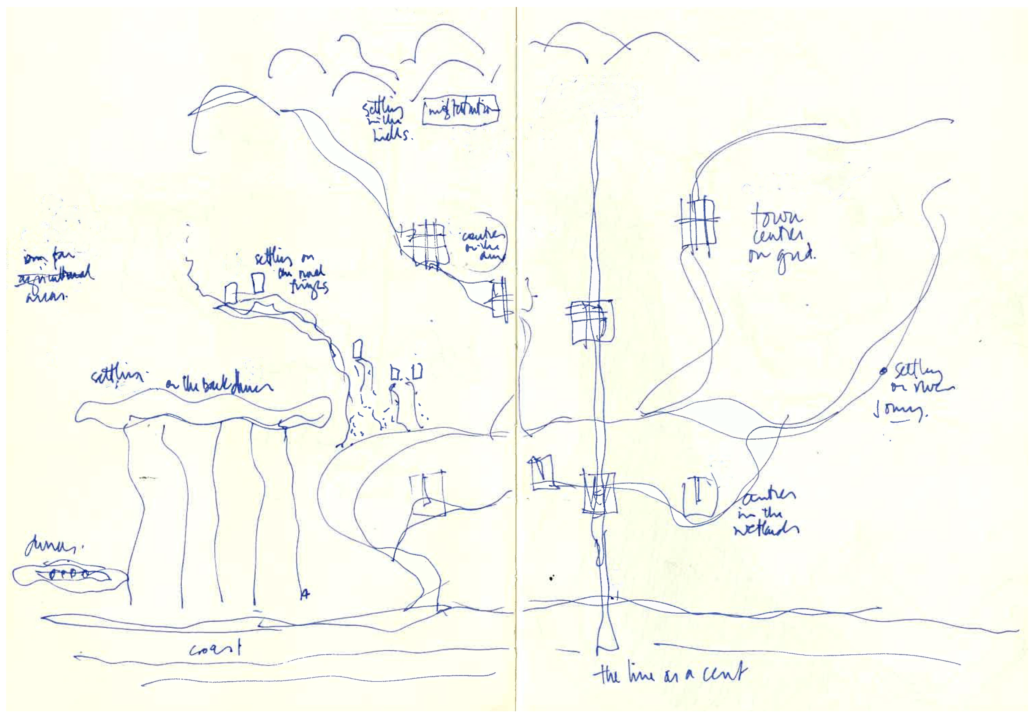
One of the common design strategies is to site catalytic interventions at the overlap of cultural, environmental and social systems, places we have called ‘sweet-spots’. ‘Sweet-spots’ are not dissimilar to the ecological concept of an ecotone, where natural ecosystems converge and are especially fertile and biodiverse, and where abundance generates contest. By siting interventions in ‘sweet-spots’ and building on the latent diversity there, the schemes suggest that the region’s natural ecosystems and landscape-based culture can have primacy in the social structure, providing a better approach to managing resources in settlement design. But how do we find ‘sweet-spots’ so we can enhance them?
In all of the schemes, these ‘sweet-spots’ have been found in leftover spaces of the region: beside hidden wetlands; amongst low density housing; on marginal dune/wetland systems beside town centres; on the underutilised quarry spaces at the edge of the suburbs; in the ecologically latent backyards of the coastal dunes; or in the less productive parts of farmland. Do these schemes suggest that we need to look for underutilised or marginal spaces as a place to start interventions in the hinterland? Perhaps, this is too simplistic.
It may be that the underutilisation of these sites has happened as the result of past planning practices: because traditional positivist and utilitarian land planning methodologies had coarse-grained data. This could only ever accommodate reductive decision making, and generate monocultural land uses which nullified the contested nature of the ‘sweet-spots’. Or it may be that past master planning was too often top-down, focused at one scale, providing an over-determined all-encompassing orthographic overlay with fixed connections between finite landscapes. These approaches are unlikely to ferment resilient or ecological frameworks that could synthesise dynamic and competing natural, cultural and social systems. In this research study, the availability of fine-grained data and the integrative potential of design research methods showed the potential at these in-between sites.
On these in-between ‘sweet-spots’, there is inherently no dominant system. With no dominant system, there is scope for designs that accommodate multiple systems working off each other to establish interdependencies such as the interdependencies between wetlands, dunes, cultural heritage, and town centres; between youth issues, community and the natural environments of suburbia; or the interdependencies between the margins of a lake, rural settlement density issues and agricultural productivity.
Each of the schemes shows the potential to build concentrations of town centre activity or neighbourhood activity or environmental activity on these sweet-spots, while establishing biodiversity and spatial diversity in the landscape. Both diversity and concentrations have inherent benefits for resilience: diversity provides options for the future; and concentrations of activity facilitate effective movement and feedback of social capital, information and energy. The design process of finding and enhancing ‘sweet-spots’ thus opens up the potential for a more resilient network of settlement. What unfolds is a guide to the design of settlement patterns that may be thought of as an ecology of local projects with regionally significant impetus (Figure 8).
3.2. Precision and Flexibility in Form-Making—Efficiency and Redundancy
The design schemes each address the intersection between the paradoxical oppositions of precise form and flexible programme. The precision is an output of form making design processes that strive for civic-ness; the flexibility provides room to develop diversity, distinctiveness and intensity within each community in the longer term. The precision shows the capacity and need to be particular to place and culture; the flexibility reveals the potential for the interventions to grow over time and across a region within the hands of locals.
In doing so, this design strategy reveals the tension between designing for efficiencies, and designing for redundancies. Efficiency is economical, but redundancies provide opportunities for diverse activities, and latent opportunities for an unknown future. Nature-based infrastructural solutions are a typical example: their extent needs to be measured for they are land hungry, but, given enough space, they have a diversity of biota that is inextricably linked with the health of natural ecosystems, resources and services and the health and vitality of a place. In schemes like ‘Shifting Downtown’ and ‘High Ground, Low Ground’ the soft infrastructure will give breathing space to the natural forces, even though it is less efficient than a hard piped solution. Built form can also have in-built programmatic redundancies. Plan B-Hive’s flexibility offers a latent redundancy in its function which has immediate benefits to the local employment issues but also scales up to the region by offering long-term options for the governance of the broader region, while still offering civic presence in its precise formal qualities.
In each, the design of form and materials address the fine grain of social micro-scales, but instead of being deterministic, they are being used catalytically through the resilient framework: to provide the potential for community and ecosystems processes to evolve and diversify; to generate innovation and identity; and to make room to adapt.
3.3. Scaling Up—Independence and Interdependence
The third design strategy that comes out of this work we have called ‘scaling up’: relying on complex uses of form and material as fine-grained starting points from which to move out to the broadscale. Scaling up draws on the tensions between the site, the field and the system—the architecture, landscape and region to accrue multiple benefits.
Multiple benefits are demonstrated in High Ground, Low Ground, through the multi-scalar design approach to infrastructure. At the local scale, the expansion of natural wetland and dune systems into backyards and streets helps re-establish a healthy ecosystem, and provides the potential of food and water resources and community interaction; and the multiple paths, realigned to link nodes to nearby facilities on high ground, establishes permeability to safety, but also encourages the potential for neighbourliness. Scaling up to the region, an expanding field emerges with multiple modularised assemblages of wetlands, paths and nodes along this coast. Collectively, they would establish a regional hierarchy of communities with multiple food sources, multiple water sources, and multiple options for safety during disasters. In Wetland Square, the proposed intervention is more built-form than infrastructural, but can still scale up to create assemblages of wetland and pier and town square, with environmental, social and cultural heritage benefits. Thus, the wetland schemes can extend into other wetlands, the town centre scheme can be repeated in other town centres, and the foothill scheme into other parts of the foothills.
Each of the schemes can be seen essentially as small schemes and a regional scheme. At each site, there is a suggestion of independence, but, collectively, the field created by scaling up suggests the potential for interdependency accrued through the multiplicity of resources, and their diversity. In the same way, hinterlands and cities are more resilient if interconnected in mutually beneficial ways to their urban region. By shifting up, the region develops an interscalar interdependence (referred to as ‘panarchy’ in resilience literature [27]). The benefits that accrue at the broadest scale point to the suitability of the local scale of these schemes as productive places to explore the resilience of this hinterland.
The intent of this strategy is not necessarily to replace top-down planning, but to augment it with a bottom up design approach, so settlement can be both contextual and site-specific, both strategic and tangible.
4. Conclusions
The output of this research is a catalogue of designs that explore, through a range of scales, design strategies that defer to the specificity of place and culture, and show ways of calibrating the tensions between the specifics of the local and regional environmental, cultural and social systems. By working with vulnerabilities, with ideas of redundancy, diversity, and interdependence, and with the primacy of natural systems and landscape-based cultures, the research suggests that ‘a Guide,’ through exemplars, might be an appropriate way to achieve much-needed innovation in sparsely populated areas. While further testing is needed, we think the designs show the potential of this design-led resiliency-framed methodology to holistically draw key issues into integrated solutions. Spatial design has an important role to play in ‘leading the way’ as we ask communities to adapt to new levels of resilience for the future.
The designs are important because they are intentionally less concerned with political boundaries, and more concerned with the specifics of culture, society and environment across and beyond political boundaries to address the interdependence of the city and hinterland as a system. We recognise that they will not replace traditional planning methods that provide comprehensive and mechanistic strategies to land use according to political needs. However, the problems associated with planning may not be able to be solved by better planning: the resilience-framed design-led research work offers a number of design strategies for considering settlement in conjunction with traditional planning methods. Together, they complement each other: urban planning with its broad-scale outlook that rationalizes land use, and design with its potential to address culture, community and environment at the site scale and at the city-hinterland scale concurrently, and with its potential to activate the tensions between efficiencies and redundancies to provide a guide to targeted developments in ‘sweet-spots’.
Our conclusion therefore is that instead of planning and policy preceding design, design has the potential to act concurrently and collectively with specific benefits that relate to the integration of nature-based and socio-cultural influences, acknowledging risks, vulnerabilities and the adaptive capacity of a place. The potential is that this kind of work can be extended to other hinterlands to re-establish the complexities of the city–hinterland relationship through interdependencies, rather than dependencies or independencies.
Settling with, rather than in spite of, the landscape and retrofitting urban areas for general resilience through spatial design acknowledges the potential of landscape’s abundance and complexity as a source of future options. It facilitates the adaptability of communities, making a difference to communities and settlements now, as well as enhancing resilience to a range of disturbances. Research into the sparseness of the hinterland, rather than the density of the city thus offers the potential to appreciate how to implement resilience as part of a planning and design agenda.
Acknowledgments
This material was first presented at the Regionalism in the Era of Globalisation conference at Huddersfield University, February 2016. Attendance at the conference and support for the research was funded by Victoria University Wellington.
Author Contributions
Martin Bryant, Penny Allan and Sam Kebbell conceived and designed the research, supervised the students who prepared individual design research studies and analysed the results. Martin Bryant wrote the paper.
Conflicts of Interest
The authors declare no conflict of interest.
References
- Sassen, S. The Global City, 2nd ed.; Princeton University Press: Princeton, NJ, USA, 2013. [Google Scholar]
- Florida, R. The Rise of the Creative Class; Basic Books: New York, NY, USA, 2002. [Google Scholar]
- Glaeser, E. Triumph of the City; Penguin Books: New York, NY, USA, 2011. [Google Scholar]
- Draft Outcome Document of the United Nations Conference on Housing and Sustainable Urban Development (Habitat III). Available online: https://www2.habitat3.org/bitcache/99d99fbd0824de50214e99f864459d8081a9be00?vid=591155&disposition=inline&op=view (accessed on 30 November 2016).
- Etymonline. Available online: http://www.etymonline.com/index.php?term=guide (accessed on 15 November 2016).
- Deming, M.; Swaffield, S. Landscape Architecture Research; John Wiley and Sons: Hoboken, NJ, USA, 2011; pp. 1–2. [Google Scholar]
- Deming, M.; Swaffield, S. Landscape Architecture Research; John Wiley and Sons: Hoboken, NJ, USA, 2011; pp. 205–221. [Google Scholar]
- Downton, P. Design Research; RMIT University Press: Melbourne, Australia, 2004. [Google Scholar]
- Stevens, Q.; Dovey, M. Appropriating the Spectatcle: Play and Politics in a Leisure Landscape. J. Urban Des. 2004, 9, 359. [Google Scholar] [CrossRef]
- Aureli, P. The Possibility of an Absolute Architecture; MIT press: Cambridge, MA, USA, 2011. [Google Scholar]
- Speaks, M. Theory was interesting but now we have work. Archit. Res. Q. 2006, 6, 209–212. [Google Scholar] [CrossRef]
- Holling, C. Engineering Resilience versus Ecological Resilience. 1996. Available online: http://books.google.co.nz/books?hl=en&lr=&id=C0q7hXOGuY8C&oi=fnd&pg=PA51&dq=holling+1996&ots=6SCzYpGa7w&sig=bf7i_D_Y5zO_bst4Kv5QMLkNaoo#v=onepage&q=holling%201996&f=false (accessed on 1 October 2012).
- Folke, C. Resilience: The Emergence of a Perspective for Social-Ecological Systems Analysis. Glob. Environ. Chang. 2006, 16, 253–267. [Google Scholar] [CrossRef]
- Helm, D. Natural Capital: Valuing the Planet; Yale University Press: New Haven, CT, USA, 2015. [Google Scholar]
- Stern, N. Why Are We Waiting? The Logic, Urgency and Promise of Tackling Climate Change; MIT: Cambridge, MA, USA, 2015. [Google Scholar]
- Resilient Design Principles: Design Principles for Creating More Resilient Cities. Available online: http://www.symbioticcities.net (accessed on 27 January 2016).
- Salat, S.; Bourdic, L.; Labbe, F. Breaking Symmetries and Emerging Scaling Urban Structures. A Morphological Tale of 3 Cities: Paris, New York and Barcelona. Int. J. Archit. Res. 2014, 8, 77–93. [Google Scholar]
- Walker, B.; Salt, D. Resilience Thinking; Island Press: Washington, DC, USA, 2006; p. 163. [Google Scholar]
- Allan, P.; Bryant, M. Resilience as a Framework for Urbanism and Recovery. J. Landsc. Archit. 2011, 6, 34–45. [Google Scholar] [CrossRef]
- Spoonley, P. Rebooting the Regions; Massey University Press: Wellington, New Zealand, 2016. [Google Scholar]
- Murray, R. Wetland Square, Market Pier. Master’s Thesis, Victoria University of Wellington, Wellington, New Zealand, 2016. [Google Scholar]
- Dewhirst, W. Shifting Downtown: Retrofitting Rural Towns to Embrace Their Natural Heritage. Master’s Thesis, Victoria University of Wellington, Wellington, New Zealand, 2015. [Google Scholar]
- Allnatt, B. Plan B Hive: An Outpost in the Hinterland. Master’s Thesis, Victoria University of Wellington, Wellington, New Zealand, 2015. [Google Scholar]
- Wallis, S. High Ground, Low Ground: Explorations in Topography and Neighbourliness in Coastal Dune Settlement. Master’s Thesis, Victoria University of Wellington, Wellington, New Zealand, 2016. [Google Scholar]
- Manaaki Taha Moana: Enhancing Coastal Systems for Iwi: State of Ecological/Cultural Landscape Decline of the Horowhenua Coastline between Hokio and Waitohu Streams. Available online: http://www.mtm.ac.nz/wp-content/uploads/2015/03/StateofHorowhenuaCoastFINAL3.pdf (accessed on 15 November 2015).
- Wheaton, N. Diversifying Density: Renovating Rural Living within Kapiti/Horowhenua Coast. Master’s Thesis, Victoria University of Wellington, Wellington, New Zealand, 2015. [Google Scholar]
- Walker, B.; Salt, D. Resilience Thinking; Island Press: Washington, DC, USA, 2006; p. 90. [Google Scholar]
Figure 1.
Map of New Zealand. Kapiti Horowhenua is located above Wellington (left) Source: Nick Wheaton. Existing settlement in Kapiti Horowhenua. Numbers denote population in 2014 (right). Source: Winston Dewhirst.
Figure 1.
Map of New Zealand. Kapiti Horowhenua is located above Wellington (left) Source: Nick Wheaton. Existing settlement in Kapiti Horowhenua. Numbers denote population in 2014 (right). Source: Winston Dewhirst.
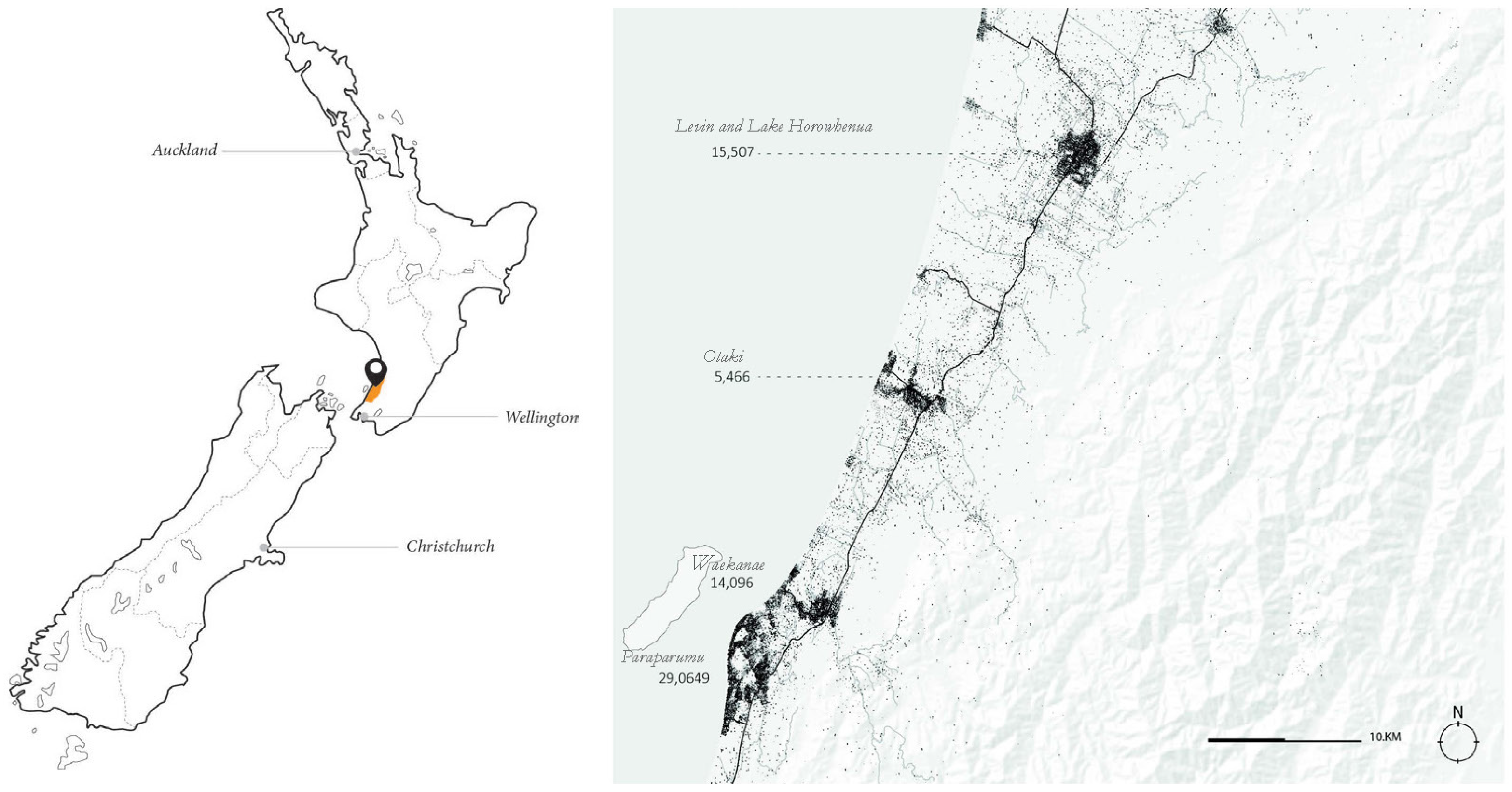
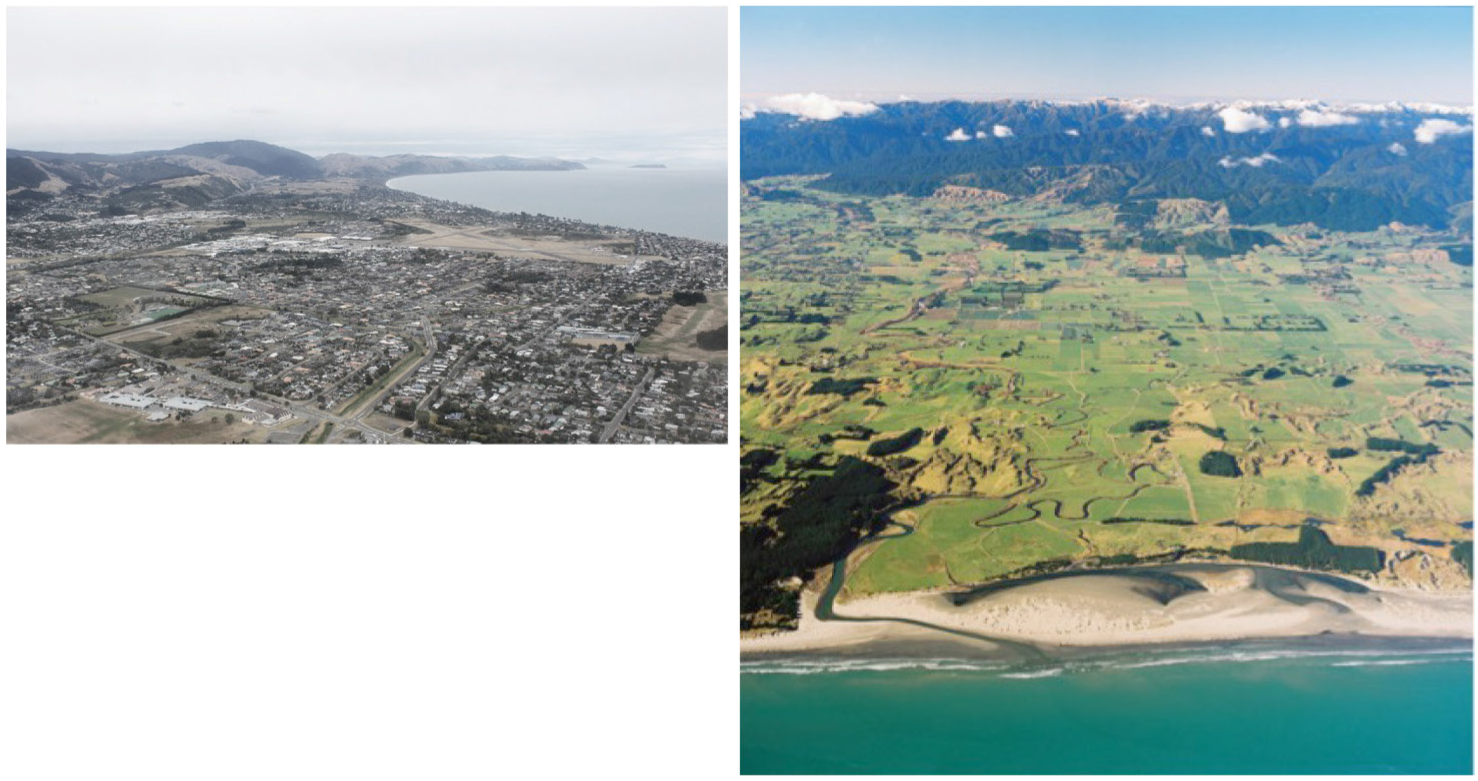
Figure 2.
Aerial photos of existing settlement near Paraparaumu (left) and farmland north of Otaki (right) Source: Ben Allnatt; Huhana Smith.
Figure 2.
Aerial photos of existing settlement near Paraparaumu (left) and farmland north of Otaki (right) Source: Ben Allnatt; Huhana Smith.

Figure 3.
Wetland Square a speculative design by Rachel Murray. Anticlockwise from top: Plan of pier; elevation of pier with new town centre buildings behind; plan of proposed Wetland Square; regional plan of Wetland Squares. Source: Rachel Murray.
Figure 3.
Wetland Square a speculative design by Rachel Murray. Anticlockwise from top: Plan of pier; elevation of pier with new town centre buildings behind; plan of proposed Wetland Square; regional plan of Wetland Squares. Source: Rachel Murray.
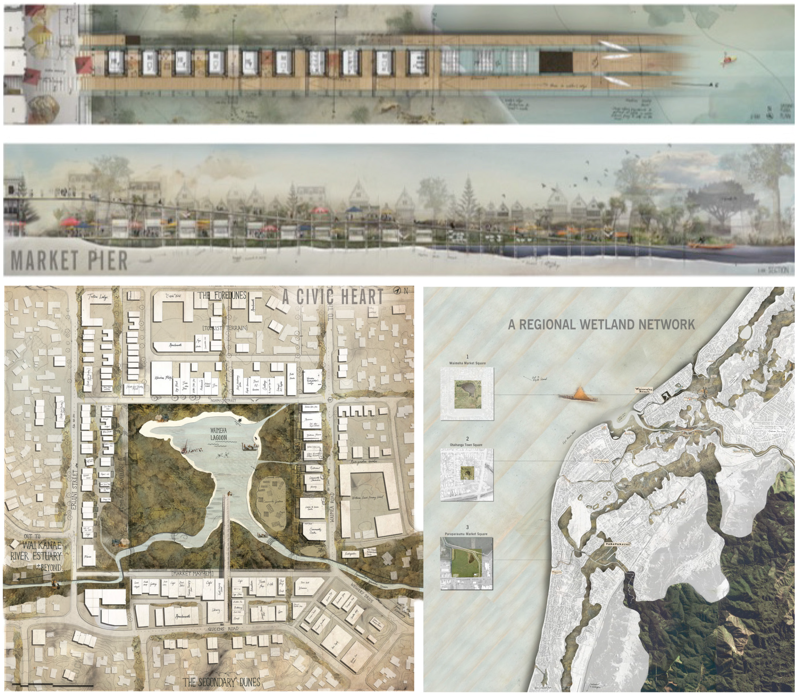
Figure 4.
Shifting Downtown, a speculative design by Winston Dewhirst. Plan of existing street grid converted to wide wetlands and dunes, linked to existing wetland and dune (left); a porous urban edge to wetland dune system (top right); compact town centre development allows streets to be converted to wetlands and dunes. Source: Winston Dewhirst.
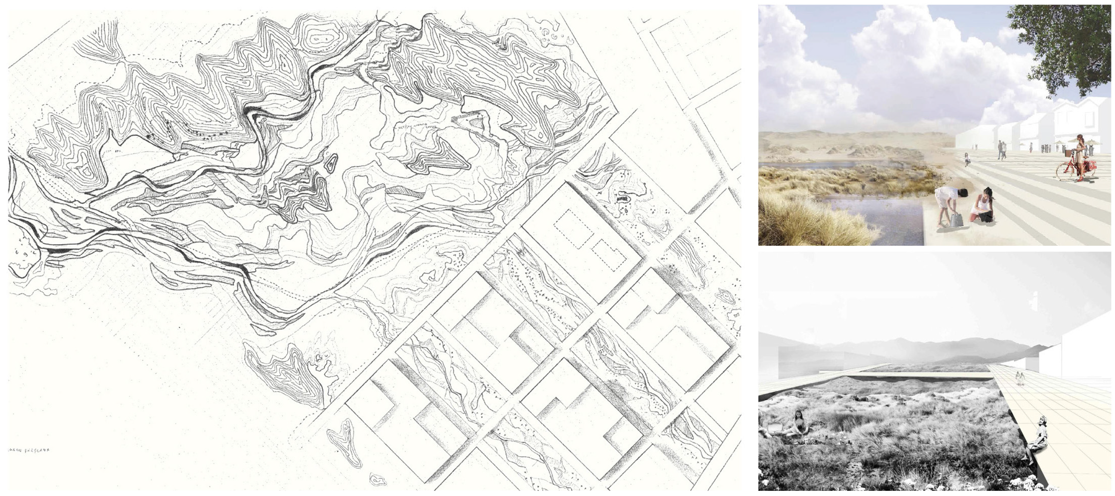
Figure 5.
Plan B hive, a speculative design by Ben Allnatt. Anticlockwise from top: axonometric of built form with roof cut away; interior view of flexible space; aerial view of site at edge of low density suburbia; proposed site plan with a series of institutional buildings engaging the edge of suburbia; section through proposed building. Source: Ben Allnatt.
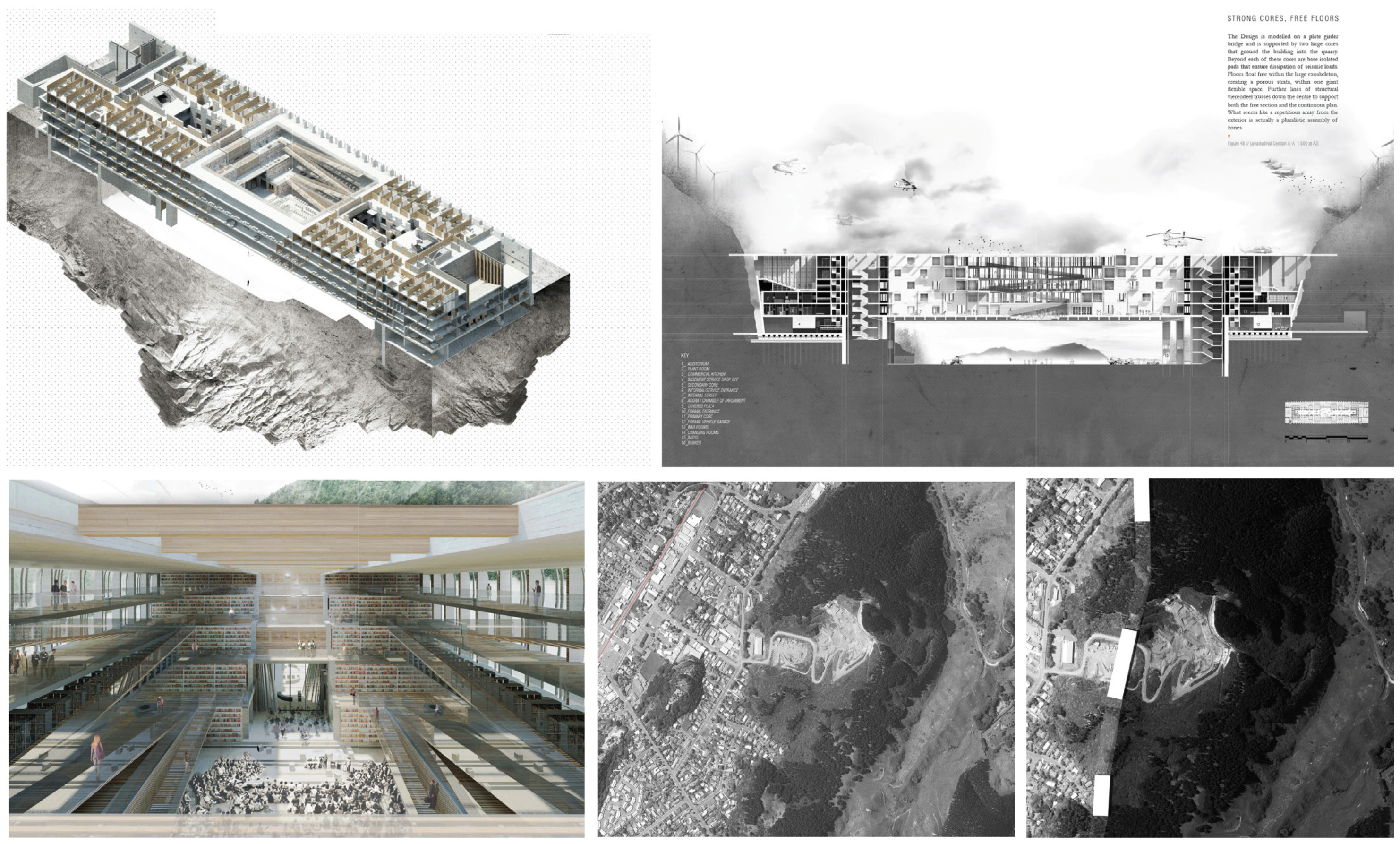
Figure 6.
High Ground, Low Ground, a speculative design by Caitlin Wallis. Plan of existing streets parallel to the coast (top left); and proposed plan of perpendicular movement lines, designed to avoid removal of any houses (bottom left); proposed image of common path through backyards to high ground in background (right). Source: Caitlin Wallis.

Figure 7.
Renovating Rural Living, a speculative design by Nick Wheaton. Left: aerial view of proposed flax producing harekeke that is endemic to wetland edges, replacing dairying. Rural community settlement and production buildings are proposed in the foreground with a road to nearby towns and Wellington. In the background is Lake Horowhenua. Right: images of rural community living that would be integrated with the production. Source: Nick Wheaton.

Figure 8.
An ecology of projects. Less a master plan, the schemes show the potential for settlement in the sweet-spots of the region, taking advantage, through design research, of the potential to integrate competing issues and opportunities and generate an ecology of compelling alternatives. Source: Martin Bryant.

© 2017 by the authors. Licensee MDPI, Basel, Switzerland. This article is an open access article distributed under the terms and conditions of the Creative Commons Attribution (CC BY) license ( http://creativecommons.org/licenses/by/4.0/).
Share and Cite
MDPI and ACS Style
Bryant, M.; Allan, P.; Kebbell, S. A Settlers’ Guide: Designing for Resilience in the Hinterlands. Buildings 2017, 7, 23. https://doi.org/10.3390/buildings7010023
AMA Style
Bryant M, Allan P, Kebbell S. A Settlers’ Guide: Designing for Resilience in the Hinterlands. Buildings. 2017; 7(1):23. https://doi.org/10.3390/buildings7010023
Chicago/Turabian StyleBryant, Martin, Penny Allan, and Sam Kebbell. 2017. "A Settlers’ Guide: Designing for Resilience in the Hinterlands" Buildings 7, no. 1: 23. https://doi.org/10.3390/buildings7010023
Note that from the first issue of 2016, this journal uses article numbers instead of page numbers. See further details here.