Rock Art in Kurdistan Iran

Independent Scholar, 4-13, Bessat Town, Sanandaj, 94415-66149, Iran
Arts 2013, 2(4), 328-349; https://doi.org/10.3390/arts2040328
Submission received: 30 August 2013
/
Revised: 25 October 2013
/
Accepted: 31 October 2013
/
Published: 5 December 2013
(This article belongs to the Collection World Rock Art)
Abstract
:Kurdistan, with great potential and prehistoric resources, has numerous petroglyphs in different areas of the province. During the last 14 years of extensive field study, more than 30 sites of rock art have been identified and introduced by the author. In this article, we summarize these rock art areas in Iranian Kurdistan.
1. Introduction
Rock art study in Iran is at the beginning of its development and this important category of cultural heritage is neglected by researchers and archaeologists. During the last two decades, most searches have been done that have been mostly focused on locating and registering the sites. Each site, for which a report was filed, was found to be neglected. Research is mostly based on reports that are available in the archives of cultural heritages offices of the provinces, and no analysis or completed studies focused on rock art have been done yet in Iran. Unfortunately, there is no rule for the studying and protection of this heritage in Iran. There is no institution in Iran to protect and support this ancient art within the International Federation of Rock Art Organizations (IFRAO) framework and provision [1]. Identifying and introduction of the rock art in Kurdistan as a free and independent researcher started in summer 1998, and an initial report was published previously [2].
Kurdistan has great prehistoric cultures, and contains numerous petroglyphs in different areas of the province. During g the last 14 years, more than 30 rock art sites have been identified and introduced by the author [1,2,3,4,5,6,7,8]. In this paper, an attempt is made to study the rock art of Kurdistan, providing a general perspective for the reader.
In order to protect the sites, the name of the villages and the locations of sites were not mentioned in prior articles, and only the name of the regions of occurrence were mentioned.
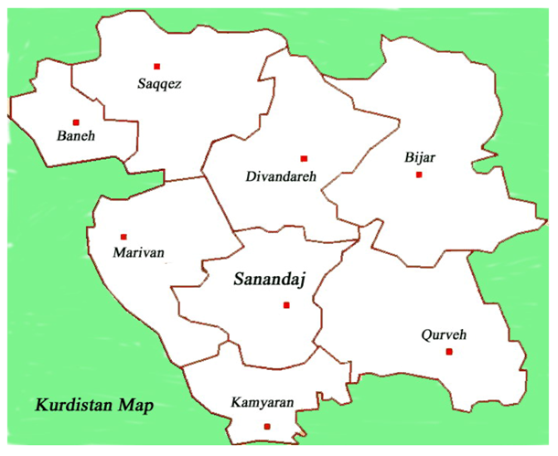
Figure 1.
Map of Kurdistan.

2. Kurdistan in Iran
Seas of the second era of geology have covered all parts of Kurdistan and a considerable amount of sediment has remained here. At the end of second era, some parts of Jurassic calcic sediments in Kurdistan emerged from the water in the form of vast lands or numerous islands [9]. According to uranium/thorium and carbon 14 experiments done on remnants belonging to the Mousterian era in Shana-Dar Cave in the Baradust mountains in Iraqi Kurdistan, their antiquity lies in the range of between 46,900 + 1500 and 60,000 years ago [10].
In Hawraman, in the Kurdistan province of Iran, there are caves and refuges adjacent to Sirwan River; most of them are to the east and located in low altitudes. Archaeologists have not delivered a report about prehistoric sites in Hawraman Kurdistan of Iran. Its caves and rock shelters have remained intact [2,7]. Although painting on potteries of the Neolithic was common, the prevalence of completely new paintings in the Chalcolithic distinguishes this era from older ones. The Chalcolithic cultures of Iran cover the middle of fifth millennium BCE, around (4300–4500), and had been common in many parts of Iran [11]. Rock art displays the artistic sensitivity and atheism of our old antecedents in many parts of the world. It is the only cultural explanation form of humans that lasts unceasingly for tens of thousands years [12].
3. Regions Including Rock Art in Kurdistan
- Hawraman region (mountainous area located among Sanandaj, Kermanshah, Mariwan, and Sharazour)
- Saral region (mountains and plains between Sanandaj and Divandareh)
- Petroglyphs in northeast of Qorveh
- Petroglyph in Karaftou cave, to the north of Divandareh, and east of Saqez
- Petrglyph to the north of Dehgolan
- Cupules in east of Saqez
- Petroglyph in Ghomchocgai, north of Bijar
- Cupules and mortars in the west of Sanandaj
3.1. Petroglyphs of Hawraman
The hillsides of beautiful mountains and valleys of the Shahou Mountains in Hawraman have an abundant collection of caves, rock shelters petroglyphs, cupules, mortars and ruined structures of ancient peoples. Unfortunately, Kurdistan’s vast region of Hawraman and the Sirwan river side in the Shahou mountains, at 3300 m altitude, has not, so far, been noticed archeologically [2,7].
3.2. Petroglyph in Daraki Village
The animal track of the Darband-Klom river can be found two kilometers north of Daraki village and this, because of high limestone mountains is the only path from the north to the south of this region, as during over thousands of years the boulders of the pass have been polished by human and animal feet. In summer 1998, in two caves called Bardmir and Tash, rock art locations were identified in this valley [2,3].
3.3. Rock Art in Bardmir Rockshelter and Tash Cave Way
The two valleys of Tash and Darband-Klom river have thousands of limestone boulders on the surface and rock wall of its mountains. On the course of the Darband-Klom river, at 1618 m altitude above the sea level, there is a small rock shelter called Bardmir, containing two boulders with rock paintings. The smaller boulder bears three “antelopes” and a big limestone block of 140 cm features four animal patterns. The prehistoric artist of this era has chosen a boulder that is very similar to a sheep head. On the left side of the boulder is an animal muzzle and on the right is the head. On the vertical surface, there are the depictions of three “antelopes” and another animal, probably a dog. The size of the biggest “antelope” is 24–25 cm. There is also another depiction, which seems to be a dog, approximately 10–17 cm in size. According to the length of the horns of these animals, one of them may be 12 years old [2,3] (Figure 2). Three hundred meters to the west of Bardmir, in a rock shelter on a smaller path that leads to the height of the valley, at 1622 m above the sea level, in a region named Ben-Ghala, there are two petroglyphs of human shapes that are holding something on their hands. There are also several ibexes engraved below the previous depictions. On the animal path, 200 m to the north of this complex of petroglyphs, in the middle of the valley, at 1680 m above sea level, the ruined remains of rooms and walls of an ancient village has remained.
3.4. The Rock Art of Tash Cave
At the end of the ancient village, in the west of the valley, there is a huge stone, under which can be found the Tash Cave. The height of the inside of the cave is 2 m and its diameter is 4 m. The interior situation of the cave and the entrance, on the left, shows that it was in used in the prehistoric era. On the outer wall of the cave, 3 m higher than the surrounding land to the east, there are some petroglyphs consisting of three “horses with riders”, one of them is holding something in his hand. They are moving to the north in a row. There are also three depictions of “ibexes” shown under the riders that with regard to patination seem to be older than the other petroglyphs. Similar images of “ibexes” and “horse riders” also exist, which based on the patination, are probably recent of age. Tash Cave is one of the prehistoric settlements of Hawraman. The pattern of ibexes in the caves of Bardmir and Martash is older than the horses and riders patterns [2]. In addition, several “ibexes” are engraved on a boulder located on a vertical wall 100 m to the west of Tash Cave.
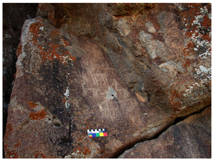
Figure 2.
Hawraman, Bendoul, Havar-Sivieh, Rangavarzhilah rock, geometric marking with dimensions of 90 cm by 106 cm.
Figure 2.
Hawraman, Bendoul, Havar-Sivieh, Rangavarzhilah rock, geometric marking with dimensions of 90 cm by 106 cm.
On the way to the ancient village, 300 m northwest of the cave, are around 10 cupules with 2 to 5 cm in diameter and maximum 2 cm of depth, on a limestone boulder. Within 5 m west of this limestone, there is a mortar with 20 cm depth and diameters [7].
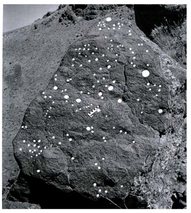
My efforts have resulted in discovering several collections of cupules in the region, which seem to belong to different periods [7,8,13]. Cupules in Kurdistan, particularly in the Hawaran region, where a great number of cupules are identified, usually occur on hillsides, plains, bank of the rivers, old springs and inside the caves [7]. These cupules have not been the results of natural agents like water, plants and minerals, but they are products of the creativity of the mind and man-made during thousands years, manifestation found in different parts of the world [14].
3.5. Petroglyps of Bendol Village
Bendol village is located 25 km southwest of Mariwan at the end of a beautiful valley. Around this village, two locations including rock art were identified.
3.5.1.Petroglyphs of Twan-Maro-Naghshi
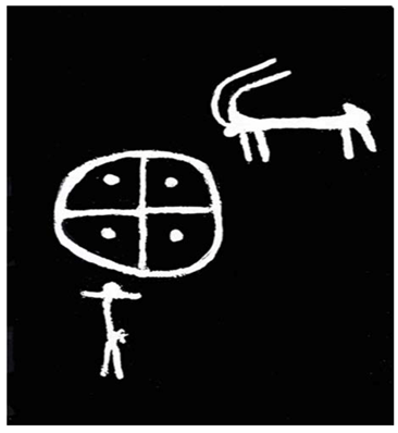
The first site is situated 300 m southwest of the village, 1600 m above sea level, on a rock called Twan-Maro-Naghshi. Three crosses and two “ibexes”, one of them depicted between circles, are identified on the rock’s surface [2] (Figure 3). These petroglyphs are comparable with a symbol in the rock art of Saymali Tash in Kirghizstan that shows the feature of sun worshiping at the beginning of the Bronze Age [15]. Sun patterns can be seen with different types and abundances in archaeology findings and as paintings on the designed utensils of Iran at least from 5th millennium BCE to the present time [16].
On the top of these patterns at a height of 5 m, on the right side of the rock, a face-like circle with 50 cm in diameter is engraved. On the left of this image at 6 m height, three involute concentric circles are engraved, their biggest diameter is around 70 cm. On the way that leads to the western heights of the village and to another site of rock art in this region, there is a cave (Marjen) opening to the east. Because this cave is located between Maronaghshi rock art sites, it has probably preserved many remains of ancient times.
3.5.2. Petroglyph of Sivieh Countryside in the Heights of Bendol Village
The place of ancient people called Sivieh in the countryside is located 2200 m above sea level, a green plain with a beautiful view and a spring that was used by the prehistoric settlers of this region. Sivieh rock art has three parts, which are located to the north and south of the countryside. Next to the spring, on the horizontal surface of a boulder of 2 m in length, there are several engraved mortars with 25 cm in diameter and a depth of 20 cm. Probably the earlier settlers of this countryside used these mortars for grinding grain in the summer. In the west of Sivieh, an area with a tall limestone wall named Rangaverzhela is located to the north, and depictions have been engraved on its vertical surface. There is a pattern of involute circles like the eye, 25 cm long and an animal, probably a dog, an “antelope”, a human shape of 13 cm in height, a half-body of a person of which the half of lower part of the body is erased. On the top of the pattern there is a big ambiguous picture of 90 × 106 cm (Figure 2). The north area of Sivieh includes an “antelope”, a circle and a human shape (Figure 4). In this part similar depictions, which are completely recent in age, have been carved by locals. On the northeast of Sivieh, beside the rock of the mountain to the west, three images have been engraved on a boulder of two meters height. An “ibex” is engraved in the middle of a circle. There are also anthropomorphs in the Sivieh area.
Figure 3.
Sivieh-Havar, a human shape on two wheels holding something in the hand and the cross motif on the right.
Figure 3.
Sivieh-Havar, a human shape on two wheels holding something in the hand and the cross motif on the right.

These human shapes sometimes are accompanied by geometric markings and seem to include a particular message or conception (Figure 3). Zoomorphs such as “antelope”, “deer” and “leopard” are also present.
Figure 4.
Hawraman, Bendoul village, Sivieh-Havar.
3.6. The Petroglyphs of Soren in Kousalan
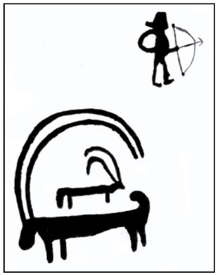
The petroglyphs of Soren are located in the southwest heights of Kousalan, 1550 m above sea level and 4 m above the surrounding area to the south of Souren. This site was identified in summer 1999 [2,3] (Figure 5). Human and animal depictions, an archer with a hat on his head and 18 cm in height are the most important petroglyphs of the site. There are also images of “antelopes”. The bigger one with horns drawn to the tail is 24 cm and is engraved on the back of small one with 9 by 9 cm dimensions (Figure 5). This depiction is comparable with “ibex” in rock art of Bayenchou and Srawghamesh area in Kurdistan and so is comparable with Koul Zhabasi petroglyph in Kazakhstan [16]. Below of these petroglyphs, there are seven “antelopes”, two tuskers and other figures, which are not recognizable due to erosion. Within 200 m of east of Souren petroglyph, there is the Asb Cave (Mar-asb), facing toward the west.
Figure 5.
Kousalan, “ibexes” and Souren petroglyphs.
3.7. The Rock Art of the Village of Dala-Marz
The village of Dala-Marz is located in 90 km of Marivan. Ten rock shelters made of limestone are located 1 km south of the village, 2200 m above sea level and 400 m from Sirwan river.
3.7.1. The Cupules and Mortars of Asl-Gah
Asl-Gah rock shelter is one the oldest settlements of Hawraman and its mortars and cupules belong to prehistory. In one of the rock shelters a cupules is identified next to seven mortars whose diameters range from 7 cm to 18 cm. Seven of them are next to each other and one of them is a little further. In other refuges, there are more single cupules and mortars.
3.7.2. Mortars and Cupules of Zardou Mara Rock Shelter
Zardou Mara rock shelter is located northwest of Dala Marz village and around 500 m from the Sirwan river. There is a long limestone wall to the east. The refuge is 4 m higher than the surrounding lands and there are seven mortars and one cupule on its surface, three of them are alone and four of them are together. Their diameters ranges from 7–10 cm. Besides them, on the steep peak of the boulder, there are cupules with 8 cm diameters and 1 cm depth. The Hana-Mari rock shelter is also located in this area and has individual cupules.
3.7.3. Cupules, Mortars and Human Depictions in Shemiran Cave
The Shemiran cave is located 2 km southwest of Dala Marz village at 1700 m elevation above sea level, and its entrance is 15 m higher than the surrounding area. About 20 m from this cave there is a spring whose water is pumped to the neighboring village. This cave has 15 m in length and 10 m in width and an approximate height of 15 m. Remaining ruins of a rectangular room on its floor with 3 m in depth, 6 m in length and 3 m in width is seen. The carving out of the room and its stone wall needed a metal axe and the remnants of axe-traces can be seen on the vertical surface. The black color of the southern corner of the room shows the presence of fires in the past, in the middle of the same wall on engraved half body (face) of a human is seen. A circle shows the head and some lines show the shoulders. Half of the face, like eyebrows, eye, nose and right cheek are clearly engraved. There is a mortar with 10 cm diameter and two individual cupules on the natural surface of the cave.
3.7.4. Rock Shapes and Mortars in Two Areas (Dowlou Lakala) of Dala Marz Village
On the way to the Doul area, there are two mortars; the diameters and depth of one of them is 25 cm and they were used for grinding grains. At a 5 m distance from them, on the horizontal surface of a boulder of 170 cm, an oval mortar with 50 cm length can be seen, which was probably used for grinding grains. On the vertical surfaces of boulders that have formed, like the pillars of ruined rooms of the area, shapes such as pictures of humans and animals are seen (Figure 6).
Figure 6.
Hawraman, Dala Marz village, Doul-Havar, a “scene” including anthropomorphs, zoomorphs and a human shape holding an arrow in the bow with stretched arms.
Figure 6.
Hawraman, Dala Marz village, Doul-Havar, a “scene” including anthropomorphs, zoomorphs and a human shape holding an arrow in the bow with stretched arms.

3.8. The Cupules of Zoum Village
In northwest of village of Zoum, at 2040 m above sea level, 100 m west of Sirwan river, there is a boulder of 4 m in length and 3 m in height bearing 70 cupules with diameters ranging from 4 to 10 cm and 2–5 cm in depth. Some of them have been engraved aciniformly on the boulder from west to east. Some are put together in groups of 2, 4, or 6. Some of the cupules on the Sirwan river way are put together in pairs. In one of the cases, a rectangular line is engraved around two cupules. On the top part, two cupules are side by side and a deep track joins them together (Lahafian 2010: Figure 2 and Figure 3) [7]. About 10 m west of these cupules, on the horizontal surface of a limestone boulder, a natural hole like a mortar (pothole) was created, probably because of erosion in the Sirwan river’s rock bed.
3.9. The Engravings of Devaznaw Village
About 300 m southwest of Devaznaw village and on the way through the Doul Kaw valley, in an area called Nal Asban (“horse shoes”), old rock art can be found. On the vertical surface of a big boulder of 10 m length and 50 cm to 2 m height above the land, human, animal and other images in different panels and related to different eras are found. “Humans” have been shown “hunting” antelopes with arrows. Dots form a collection of 10 cm in diameter which local people call the horseshoe, hence the name of the place. There are two circles of 8 cm diameters and a hole in them, which are comparable with circle images and dots in Sivieh’s Havar in Bendoul village in Hawraman. There is an interesting image of a big dog-like animal with long tail, probably a leopard, with a head of an “antelope”. There are a lot of human and animal images in a tiny and miniature style drawn here, which are eroding.
3.10. The Rock Art of Palangan Village
Palangan village is located in 50 km west of Kamyaran, around 1 km north of this valley and 200 m of Sirwan river. In a place called Sarban, five mortars and two cupules are engraved on the horizontal surface of four boulders. On the horizontal surface of one of the boulders, two mortars of 10 cm diameter and two cupules of 4 cm in diameter have been engraved (Figure 7). Three other mortars with 10 cm in diameter are carved individually on the horizontal surface of three other boulders. Some 3 km west of Palangan village in the heights above the Sirwan river, on the surface of boulders, footprints of humans have been carved. About 200 m south of the village, and north of the Sirwan river way, on the horizontal surface of a boulder, four oval mortars and a conical mortar are located. About 5 km west of Palangan village, and on the Sirwan river way to Devaznaw, there are oval mortars that are famous as “Gabr footprints”.
Figure 7.
Hawramn, Palangan village, two mortars with 10 cm diameters on the right and two cupules on the left with 4 cm diameter and cup and ring marks, which are connected with a groove.
Figure 7.
Hawramn, Palangan village, two mortars with 10 cm diameters on the right and two cupules on the left with 4 cm diameter and cup and ring marks, which are connected with a groove.
At a distance of 2 km southwest of these mortars there is a cave called Kolo Mari, with an approximate height of 7 m and a depth of 19 m, facing north, containing a mortar. On the vertical surface of the western wall, two single figures have been engraved. The figure of an animal, probably a horse, and the figure of human raising the hands, with some parts of its hands destroyed.
3.11. Saral Region Rock Art
A large portion of the petroglyphs of Iranian Kurdistan is located in Saral. Some of the petroglyph motifs in the Saral region cannot be observed in any other parts of Iranian Kurdistan; they are masterpieces among the rock arts of the province.
The drawings include motifs that seem to depict horses and riders, deer with different types of antlers, elk, women and men that maybe dressed or naked, wolves, foxes, rabbits, camels, hunting dogs, leopard, boars, snakes, trees, other plants, and geometric shapes such as circle with a smaller one in the center of that square they have depicted rectangle and diamond. Antelopes are extinct in the Saral mountains but according to the statements of the witnesses like the elderly of the region, there were big herds of antelopes in the mountains and plains of this region forty years ago. It seems that there have been herds of deer, elks and antelopes in earlier. More of engraved drawings on the rocks in Saral region are available during the periods that still have flowing creeks. Saral pastures are still a good place for settling the herdsmen [2].
3.12. Petroglyphs of Saroughamesh Village
This village is located 12 km north of Sanandaj city and 2 km west of Gheshlagh Dam Lake in the hillside of a long valley extending to the west of the lake and west of the village. This area includes many remnants of settlements from prehistory, and the first and second millennium BCE. Kalakan mountain is located 3 km southwest of the village. The peak of the mountain has ruins of an ancient castle that is famous, and known as Kalakan castle. In the west side of the mountain peak, there is a cave, which is known as Kalakan Cave. This shelter is under a high limestone wall of approximately 30 m height. The dimensions of the shelter are 3 m wide, 5 m deep and 1 to 2 m high. Mohammad Kordawani, archaeologist, has visited this shelter and wrote in his report: “Kalakan Cave is one of the oldest focuses of human settlement in the period of collecting and eating the food in this area that has remnants contemporary with Neolithic utensils in Karaftou Cave” [17]. Some 6 km east, there are Ghelichian, Bavarez, and Kolahard castles; 1 km north of Saroughamesh village is a big quartz boulder bearing petroglyphs. This area was identified in 2004. This boulder is to the southeast and its size is 2 m wide and more than 6 m long. Abundant figures can be seen over it: “Horse riders”, a “horse” without a rider, “antelope”, other symbols, and abundant figures of dots. Carvings have been created with sharp and hard tools. In the northern section of this rock, there are a lot of dots over the vertical surface; beside this big boulder on a single boulder an “antelope” has been engraved. With regard to the iconography, some of the petroglyphs at the site such as horse riders cannot be older than first millennium BCE.
3.13. Mamoukh Neck Petroglyphs in North of Sanandaj
After a further 25 km on the asphalt road of Sanandaj to Divandareh in the western heights of Mamoukh neck, on a 2 m long and 1 m wide boulder, petroglyphs have been found. This rock is exfoliating and a lot of natural destruction has occurred on it; most of the figures are wiped out. “Antelope” images and three patterns of cross have been drawn on this boulder. One of the early images of the cross, in Mamoukh petroglyphs, is comparable with the Khorasan-e-shomali petroglyph [18]. Graphic pictures of “antelope” and a circle-like symbol, which is divided into two, are engraved on this boulder. On the left side of the boulder, there is a big image of what appears to be a tree or a plant of 50 cm in height.
3.14. Kouchekcharmeg Village Petroglyph
There are several rock art sites in the valleys and heights of this village. One of the areas is located in Shajou Mountain, Kani Reihan, in a place called Kal Ba. There are a lot of images on the surface of these outspread boulders with different dimensions, which were probably created during two periods. The area where these images have been created was a good place for those hunters who were chasing antelope, deer, and elk with their fast horses in the low plains [2] (Figure 8 and Figure 9).
Figure 8.
Saral, Kouchekcharmeg village, Sha Jou Mountain, “horse riders” “hunting”.

Figure 9.
Saral, Kouchekcharmeg village, Sha Jou Mountain, zoomorphs, geometric markings on a single boulder.
Figure 9.
Saral, Kouchekcharmeg village, Sha Jou Mountain, zoomorphs, geometric markings on a single boulder.
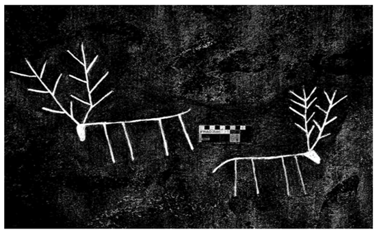
The biggest boulder bears images vertically facing east and has the most motifs of this site (Figure 8). Images like “antelope”, “elk”, “gazelle”, “ibex”, “hog”, “human” images in different attitudes, a “horse and its rider” and geometric markings can be seen here. In the middle of the boulder, there is an “elk” of 47 cm in height [2] (Figure 8). The biggest image of this boulder is a “running human” of 50 cm in height. According to historical texts, horses were very common in ancient times and were one of the taxes that the Maad paid to Assyrians. Kurdistan horses are from Nesaei race. The horse is used in a very limited way in Kurdistan now. A picture of a small animal, probably a dog, has been engraved on the top of other images (Figure 9).
3.15. Petroglyphs in Bayenchou Village
There is a row of boulders 1 km southwest of Bayenchou village in the northern hillside of Sakhnakh Mountain, bearing petroglyphs on horizontal and vertical surfaces. This area is known as Shah Abbasi to people of the village. There are images of five animals, probably horses, which are drawn on a big boulder to the north, 4 m higher than the surrounding lands, with approximate dimensions of 12 to 29 cm. There is a circle between the third and the fourth horse, another geometric image like a rectangle is engraved between the legs of the third horse (Lahafian 2004: Figure 8) [2]. On the top of these figures, another image of an engraved “horse” is fading. “Antelope” images have been carved of the left side of this region. There are also images of “rabbits”, horned animals and a long-necked animal and “human” images with “arrow and bow” and circle and square symbols in this area. Bayenchou village valleys and Kouchek Charmeg have excellent petroglyphs (Figure 6, Figure 10 and Figure 11 and the photo on the cover in Lahafian 2004) [2]. Saral artists of Kurdistan have created a sample of graphic, animated, perspectival, abstract images and geometric patterns style. They have exhibited panels with antelope images, which is a common motif in the rock art of Iran, zoomorphs, probably leopard or lion and abstract motifs circle like dots and ‘snake’ images (Figure 10 and Figure 11).
Figure 10.
Saral, valleys of Kouchekcharmeg village on the vertical surface of a boulder, big spiral images, “antelope”, “deer”, and other motifs.
Figure 10.
Saral, valleys of Kouchekcharmeg village on the vertical surface of a boulder, big spiral images, “antelope”, “deer”, and other motifs.
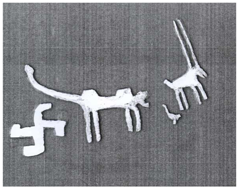
Figure 11.
Saral, valley of Bayenchou village, depictions of a swastika and three zoomorphs.

3.16. Cupules and Petroglyphs in Afrasiaw Village
About 1 km west of Afrasiaw village in a valley called Pesht Tang on the steep surface of a 14 m boulder to the south, tens of cupules with different dimensions from 1 to 7 cm have been hammered. Some form circular patterns, some are paired or in linear groups. There is a cupule with 5 cm diameter on the boulder’s peak. On the left side of the bottom of the boulder six small circle-like couples with 2 cm in diameter have been carved. In the middle of the circle, there is a cupule that has been created on this boulder as a line (Figure 12).
Figure 12.
The cupules of Afrasiaw village, the order of these cupules in this boulder is thought to be deliberate. Some are engraved circle like and some in pairs or in line.
Figure 12.
The cupules of Afrasiaw village, the order of these cupules in this boulder is thought to be deliberate. Some are engraved circle like and some in pairs or in line.
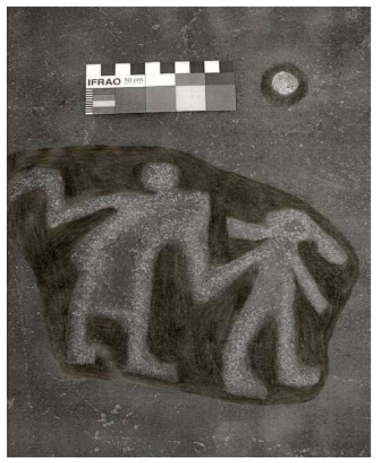
About 10 m southwest of these cupules is a boulder of 3 m in height. Cupules have been carved on its vertical surface facing west as a line. On the top of the boulder, two anthropomorphs holding hands can be seen (Figure 13). There is a cupule above their heads [7].
Figure 13.
Saral, Afrasiw village, a pattern of two anthropomorphs.
3.17. Footprints and Cupules in Hazar-Kanian Village
Hazar-Kanian village is located 120 km north of Sanandaj. In this mountainous area, cupules are located in a hillside 3 km south of the village at an elevation of 1970 m above sea level, among mountains of 3000 m in height; especially Chel Chama Mountain, with 3300 m in height, from which flows abundant streams. The heights, valleys and hillsides of these beautiful mountains have rock art and ancient remains. In this rock art site, on the vertical surface of the rocks, ten human footprints and two cupules have been carved. These footprints are of different sizes, from 20 cm to 63 cm long and with the depth of 1 to 10 cm. Because some of the footprints have been carved larger than the normal size, they are famous as “demon footprints” among the local people. These footprints have been carved on the floor in one case and in the other cases, were carved on the vertical wall of the rocks at a height of 50 cm to 1 m, facing different directions. Some of them occur beside natural cracks. In Kurdistan, footprints are mostly identified individually in different regions. In addition, the aggregation of several footprints and cupules in this site is very important. Next to these footprints, two cupules occur on the vertical surface of the rock, 1 m higher than the land, one being 10 cm diameter and 2 cm deep [7].
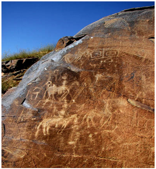
3.18. Rock Art in Qorwa
Qorwa is a town in the west of Kurdistan. The Kal-Far rock art site is about 30 km northeast of Qorwa and 6 km northwest of Ghezljakand village, 1930 m above the sea level, and extends over about 1 km. Far away in the south, on the other side of the plain, the Bour and Parishan mountains across from the Kal Far site have created a beautiful view for the rock art of this area in Kurdistan. Great boulders have covered the area, and petroglyphs of humans and animals can be seen on them. These include purported depictions of antelope, ibex, horse and rider, camel, snake and other zoomorphs, human-like shapes and other graphic forms (Figure 14). Unfortunately, shepherds and other local people have disfigured this rock art by writing their names over the petroglyphs. The rock art of this place was probably created during several periods (Figure 15). In addition to these pictures, there are small cupules and ancient images of ‘ibex’ in this area that are fading.
Figure 14.
Qorwa, human-like images in different situations, dots and animals.
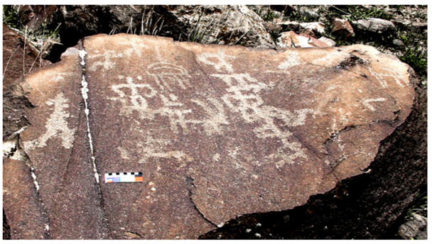
Figure 15.
Qorwa, a big rock panel occurring on a steep surface and horizontal to the south, two periods are represented by anthropomorphs, zoomorphs and geometric patterns.
Figure 15.
Qorwa, a big rock panel occurring on a steep surface and horizontal to the south, two periods are represented by anthropomorphs, zoomorphs and geometric patterns.
There are cupules at most parts of the Kurdistan rock art sites. At Kal-Far, small cupules are seen individually or in groups. On a boulder of 1 m length and 70 cm height, there is a cluster of 23 cupules with 2 cm diameter and 1 cm depth. In addition, there are also another three cupules of a diameter and depth of 6 cm and 4 cm, respectively. On the steep surface of another boulder, facing south, there is a picture of a “human” putting his left hand on the waist, with three cupules. The diameter of one of the cupules is 8 cm and its depth is 3 cm. On the vertical wall of another boulder occur 13 cupules of 2 cm diameters. On the vertical surface of a boulder facing east, there is a line of cupules with animal and human depiction [7].
3.19. Petroglyphs in Karaftou Cave
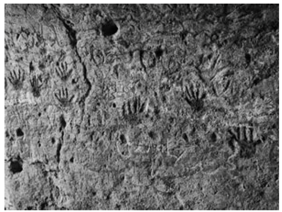
This site is located to the north of Divandareh and 74 km from Saqez. Based on geological studies, the rock at Karaftou is a folded Oligocene limestone with lines of disconformities in limited areas of Bijar and Divandareh [9]. Karaftou Cave is located between the historic sites of Zivieh and Takht-e-Soleiman. The cave was discovered by an English doctor, G. Gormick, in 1819, and was at that time first described by Kerporter in 1822 [19]. Rawlinson also visited it in 1838. One hundred years later, Estin completed its map in 1940. Rasoul Eshtoudan checked Karaftou Cave in 1994 [20]. Other archaeologists have studied the site and its region during several phases [21]. According to archaeologist’s statements, the existence of evidence inside and outside of the cave shows human usage of this cave during prehistoric times [22]. The author went to Karaftou in 1999 for the first time after identifying rock art sites of Kurdistan, not because of its extraordinary architecture, but because of the rock art of different periods. Moreover, he had a lot of experience of other rock art in different areas of Kurdistan, which other explorers lacked. Rock images of this cave were studied and photographed frequently by the author [2,3,4,5,6,7,8]. The main opening of the cave is 17 m high above the ground, which renders the use of a ladder necessary for access. In ancient periods, people have cut rooms, lobbies and doors inside the cave, forming four stories. The cave had thus been an impenetrable fortress in the past. The Karaftou region was one of the main centers of the Manna rule in the west of Iran, in the first millennium BCE. Only the patience of Median carvers could create such splendid architecture. So many rooms and lobbies cut into the heart of the mountain, arranged in various floors relating to each other, surprise any viewer. Without doubt, the type of hammer and chisel used by the carvers was made of iron. People living in this area feared the violent armies of the Assyrians, and presumably carved this castle into a natural cave. The Karaftou fortress has been used in different periods, which is apparent from architectural styles used in it as well as from petroglyphs on the walls. More recent traces also exist, including a Greek epigraph and an inscription related to the Islamic period. However, most of the petroglyphs in the cave belong to the building and people’s usage of the cave (Figure 18). The motifs found in Karaftou Cave appear to depict horses and riders, men, wild goats, elks, camels, human hands, geometrical shapes and apparently symbolic images or signs and cupules (Figure 16).
Figure 16.
Karaftou Cave, drawing of two cervids.
These images are present in most of the carved rooms into the rock. Unfortunately, some of these images have been damaged during early times as a result of alterations in the architecture. The petroglyphs have suffered more damage through of the painted graffiti and inscriptions by the visitors. On the whole, the petroglyphs of Karaftou Cave are very similar to those in the Saral area with a very similar motif range [2,3,7].
In most of the rooms and natural and man-made lobbies of Karaftou Cave, there are small and big cupules, with diameters ranging from 2 to 10 cm. Mortars and bigger hollows on the floor and lobbies were practical and used for grinding grains and storing water. In addition, some of them were connected by creating networks on the surface. The mortars’ diameter is more than 10 cm and reaches 40 cm, but they are not a part of rock art. On the fourth floor of the cave, there are small cupules with diameter and depth of 1 to 2 cm. Cupules are mostly found on the vertical surface of the walls and horizontal steep surface of natural rooms of the Karaftou Cave system. On the vertical surface of the walls, cupules have been carved next to other petroglyphs, especially next to the human’s hands. The hands occur individually and as a group in this rock art site. Some of the cupules have been carved on the vertical surface of the walls and on the older petroglyphs (Figure 17). In one of the natural lobbies of the cave, at 3 m height on a horizontal surface, several groups of cupules with 2 to 5 cm diameters have been made. The hands of this rock art site include those of men, women and children.
Figure 17.
The hand petroglyphs of Karaftou Cave next to the cupules on the vertical surface of the cave.
Figure 17.
The hand petroglyphs of Karaftou Cave next to the cupules on the vertical surface of the cave.

On the floor of one of the rooms, there are many different mortars and on its door it shows the image of a hand of a woman with a cup beside her that shows her feminine features. There are abundant collections of small hands of children beside each other on the vertical surface of one of the walls. Karaftou Cave has more than 20 such hand images. The hand images in rock art of different regions of Iran show that this motif has been common during different centuries, from contemporary time to the pre-historic one in Iranian local cultures (Figure 18). Therefore, we cannot give an age estimate for the hand images in Karaftou Cave [8]. As a result of research in the region, the author found out that the surrounding mountains around the Karaftou Cave have petroglyphs too [2]. In the heights that Karaftou Cave is located, 200 m to the north of the cave, there is a big limestone shelter with the approximate length of 20 m and the depth of 2 m. Rock art occurs on its vertical walls and its horizontal surface. Animal images and other symbols are eroding. There are other images on the horizontal surface of the shelter and they are in a deep engraving style.
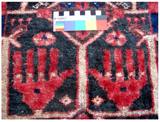
Figure 18.
The hand form on a handmade carpet related to 100 years ago, woven in Saral in Kurdistan.
Figure 18.
The hand form on a handmade carpet related to 100 years ago, woven in Saral in Kurdistan.
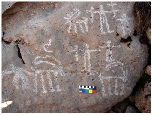
Individual cupules and three collections of cupules are in a linear row. There are two small and big hands with deep petroglyphs on the horizontal surface of the shelter (Figure 19) and an individual image of a broken cross which is comparable with the broken cross in Shah-Jou Mountain rock art in Kouchek-Charmeg in Saral. There are also individual mortars engraved on the horizontal surface of the shelter.
Kani-Michael Cave is located 2 km northeast of Karaftou Cave. This cave was excavated and studied by Iranian archaeologists in 2001. In their preliminary report, they write that Kani-Michael Cave is about 2100 m above sea level, and they conclude that they did not find any evidence of human settlement in the Paleolithic period. They found evidence of a first settlement of pastoral people in the sixth and fifth millennium BCE [22].
3.20. Petroglyphs in Dehgolan
Dehgolan is located in 50 km east of Sanandaj. This city is located in Dehgolan plain of 62,700 hectares and 1800 m above sea level. Around 30 km north of this city (Kholineh or Zafar-Abad) a village is located, and 1 km east of the village on the western hillside of Sheila mountain, 1917 m above sea level, the Dehgolan petroglyphs can be seen on the southern side of a boulder with 270 cm height (Figure 20).
The existing pictures include four “horses” and their “riders”, two “elk”, one “antelope” and an image that seems to be a fish and “hunting riders”. Based on plant covering and abundant water, the Dehgolan plain was a suitable hunting place for people. This plain starts from Salvation Abad mountains and ends in Bour and Parishan mountains in Qorwah. The “deer” image shows that Dehgolan plain was a good settlement for deer [2,3,4,5].
Figure 19.
Rock shelter of Karaftou Cave heights; the hand petroglyphs on the horizontal surface of the shelter are created with deep carving.
Figure 19.
Rock shelter of Karaftou Cave heights; the hand petroglyphs on the horizontal surface of the shelter are created with deep carving.
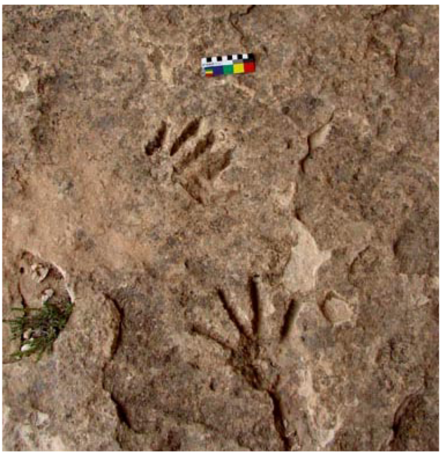
Figure 20.
Dehgolan, Zafar Awa village, part of a petroglyph, three “horse riders” chasing two “antelopes”. In the middle of the picture, human destruction can be seen.
Figure 20.
Dehgolan, Zafar Awa village, part of a petroglyph, three “horse riders” chasing two “antelopes”. In the middle of the picture, human destruction can be seen.

3.21. Petroglyphs in East of Saqez
About 25 km to the east of Saqez, a town in Kurdistan province, there are the cupules on Be Wara hill. The area with 20 km radius in which the cupules are located was an important empire center of Mad from 700 to 900 BCE, comprising numerous remains. According to the ceramics found on Be Wara Hill, there was much occupation about 1000 years BCE, and also 4000 BCE. On the top of a hill, 10 m high and 1500 m above sea level, on a bedrock exposure 7 m long and 2 to 6 m wide, fifty cupules were found. Nine of them form a circle with one in their center. Their pattern matches with Saral cupules, where five to ten cupules have been found pounded around one or two other cupules.
3.22. Qamchoghai Petro Glyphs in North of Bijar
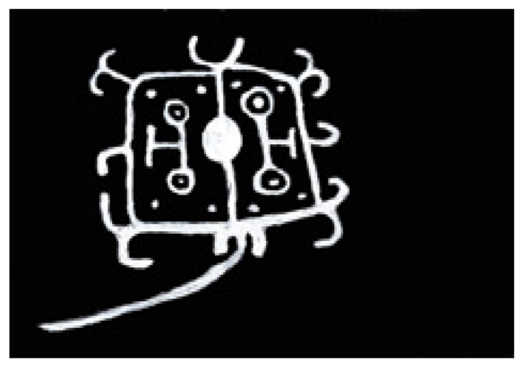
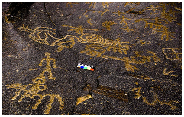
In these cases, I have used written reports of Mahmoud Kowrdavani [17]. The author studied Ghamchoghai petroglyphs in 2000 and 2001 [2], 37 years after their examination by Mahmoud Kowrdavani. Ghamchoghai petroglyphs are of geometric forms and are not related to a specific period. Most of the motifs in Ghamchoghai rock art are available in that of Karaftou Cave and at Bayenchou and Kuchek Charmag villages (Figure 21).
Figure 21.
The petroglyphs of Bijar-Ghamchoghai village.

3.23. Sanandaj West Ward Cupules and Mortars
About 40 km west of Sanandaj there is a hill 100 m above the surrounding areas, called Kuchek Charmeg, covered with rock panels. On its eastern part, 1680 m above sea level, there are ten cupules and one mortar.
4. Conclusion
There is no protection for rock art sites in Iran right now. There is just one boulder protected in Lakh Mazar in Birjand [23]. There are two main reasons for the Kurdistan petroglyphs destruction: (1) unfortunately, over recent decades, graffiti and remaking of rock art motifs can be seen; (2) natural factors like cold and heat, rain and erosion have an impact on rock art images. The plentiful and scattered rock art sites in Kurdistan are related to different periods. The rock art of this province includes all important factors, which have been found in other parts of the world. Cupules of different sizes in groups or individually are plentiful, in different arrangements such as circles of 5 to 10 cupules with one or two cupules carved in the middle of them.
Acknowledgments
The help of Hadad Zamaniin translating this paper into English is greatly appreciated. The great help of Robert. G. Bednarik also is highly acknowledged. I also thank Borhan Lohoni, Ahmad Mohammad Rezai and all of those who helped me throughout this work.
Conflicts of Interest
The authors declare no conflict of interest.
References
- J. Lahafian. “The Honourable Head of Iran’s Cultural Heritage Archaeology and Tourism.” In IFRAO Report, IFRAO Global State of the Art with the UISPP 15th Congress, Lisbon, Portugal, 9 September 2006; 2006, Volume 36. [Google Scholar]
- J. Lahafian. “Petroglyphs of Kurdistan.” Rock Art Res. 21 (2004): 3–10. [Google Scholar]
- J. Lahafian. “Prehistoric petroglyphs of Kurdistan.” Persain J. Kurd. Cult. 3–4 (2000): 14–20. [Google Scholar]
- J. Lahafian. “Hawraman in prehistory.” Persian J. Kurd. Cult. 7–8 (2001): 59–63. [Google Scholar]
- J. Lahafian. “Study of the Kurdistan pertroglyphs.” (in persian). 2001, Unpublished work. [Google Scholar]
- J. Lahafian. “Petroglyphs of Kurdistan.” Kurd. Hazar Mird J. 26 (2005): 43–59. [Google Scholar]
- J. Lahafian. “Cupules in Kurdistan rock art.” Rock Art Research. 27 (2010): 177–183. [Google Scholar]
- J. Lahafian. “Cupules in rock art of Kurdistan.” Persian Archaeology J. Pajooheshhay Bastanshenasi 4–5 (2011): 79–88. [Google Scholar]
- F. Mahmoodi. Regional Geography of Qurveh, Bijar and Divandarreh. (in Persian). Tehran, Iran: Tehran university publishing, 1973. [Google Scholar]
- K.P. Oakley. Framework for Dating Fossil Man, 3rd Edition ed. Chicago, IL, USA: Adline Publishing Company, 1968. [Google Scholar]
- H. Talaei. “Bronz Age of Iran.” In Research and Codification of Humanity Science University’s books. Tehran, Iran: Samt Publications, Research and Development of Humanity Science Center, 2006. [Google Scholar]
- J.T. Mary. “Globalization of the rock art.” UNESCO Message. Mag. 335 (1998): 38. [Google Scholar]
- J. Lahafian. The Report of Identifying the Oldest Petroglyphs of Iran in Kurdistan, Sanandaj, Iran: Cultural Heritage Organization of Iran, 1998, Unpublished work.
- R.G. Bednarik. “Cupules.” Rock Art Res. 25 (2008): 66–100. [Google Scholar]
- G. Framkin. History of Civilazation of Central Asia, Volume I, The Dawn of Civilization: Earliest Times to 700 B.C., 2nd impression ed. Paris, France: Unesco Publishing, Printed by Imprimerie des Presses Universitaires de France, Vendom, 1996. [Google Scholar]
- H. Talaei. Iran’s Iron Age. Tehran, Iran: Samt Publication, 2010. [Google Scholar]
- M. Kurdowani. Unpublished Report in Archive of the Cultural Heritage Organization of Kurdistan Province. Sanandaj, Iran: In Persian, 1969. [Google Scholar]
- A. Vahdati. Two Complexes of Petroglyphs in Khorasan-e-Shomali, Jorbat and Nargeslooy-e-Olya. Birjand, Iran: The Cultural Heritage Organization, 2010. [Google Scholar]
- R. Kerpoter. Travels in Georgia, Persian, and Armenia. London, UK: Ancient Babylonia, 1822. [Google Scholar]
- R. Oshtudan. “The Survey of Karaftu Cave.” M.A Thesis, Tehran University, Tehran, Iran, 1994. [Google Scholar]
- M. Hamzelu, and M. Mireskandary. “Castle and cave of Karaftou.” Persian J. Asar 33–34 (2002): 278–304. [Google Scholar]
- K. Rustaei, H. Rezvani, S. Heidari, D. Biglari, and N. Miller. “Preliminary report of excavation in Kani-Michail Cave in Kurdistan, August and September 2001.” Pesian J. Archaeol. Hist. 16 (2002): 72–74. [Google Scholar]
- R.L. Khaniki, and R. Bashash. “Petroglyphs of Lakhmazar in Birjand.” Res. Articles Cult. Herit. Organ. Tehran 1 (1994): 4–74. [Google Scholar]
© 2013 by the authors; licensee MDPI, Basel, Switzerland. This article is an open access article distributed under the terms and conditions of the Creative Commons Attribution license (http://creativecommons.org/licenses/by/3.0/).
Share and Cite
MDPI and ACS Style
Lahafian, J. Rock Art in Kurdistan Iran. Arts 2013, 2, 328-349. https://doi.org/10.3390/arts2040328
AMA Style
Lahafian J. Rock Art in Kurdistan Iran. Arts. 2013; 2(4):328-349. https://doi.org/10.3390/arts2040328
Chicago/Turabian StyleLahafian, Jamal. 2013. "Rock Art in Kurdistan Iran" Arts 2, no. 4: 328-349. https://doi.org/10.3390/arts2040328