Article

Lower Paleogene Tectonostratigraphy of Balochistan: Evidence for Time-Transgressive Late Paleocene-Early Eocene Uplift

by
Intizar H. Khan
1 and
William C. Clyde
2,*
1
Geological Survey of Pakistan, Sariab Road, Quetta, Pakistan
2
Department of Earth Sciences, University of New Hampshire, Durham, NH 03824, USA
*
Author to whom correspondence should be addressed.
Geosciences 2013, 3(3), 466-501; https://doi.org/10.3390/geosciences3030466
Submission received: 1 June 2013 / Revised: 19 July 2013 / Accepted: 19 July 2013 / Published: 29 July 2013
(This article belongs to the Special Issue Sedimentary Basins and Orogenic Belts)

Abstract

:
Analysis of lithofacies, paleoflow directions, and sandstone petrography of upper Paleocene-lower Eocene paralic and continental sediments exposed along the transpressional suture zone of the western margin of the Indian plate indicate that the process of deformation and uplift of the carbonate shelf in this area had started by late Paleocene time. This tectonic uplift and deformation is documented by: (1) an overall shallowing upward synorogenic sequence of sediments, (2) proximal conglomerate facies (consisting of lower Paleocene and Mesozoic clasts) dominating in the western part of the study area and distal facies of sandstone and shale dominating in the eastern part of the study area, (3) the existence of an unconformity of late Paleocene-early Eocene age in the Quetta and Kalat regions, (4) paleocurrent directions in deltaic and fluvial deposits indicating southeastward flowing sediment dispersal paths during late Paleocene-early Eocene time, which is opposite to that found in the late Cretaceous, suggesting a reversal in the depositional slope of the Cretaceous shelf, and (5) petrographic study of sandstones indicating a collision suture/fold thrust belt provenance. This episode of uplift and deformation could be the result of India-Arabian transpression with associated ophiolite obduction or, more likely, to represent the local response to initial India-Asia contact. The unroofing pattern and uplift geometry of the western Indian shelf suggests that this tectonism first started in the southern part of the study area (Kalat-Khuzdar area) during the late Paleocene-early Eocene and proceeded northward in a time-transgressive fashion.

1. Introduction

The collision between the Indo-Pakistan sub-continent and the Asian continent has generated the largest uplifted landmass in the world, the Tibetan Plateau and the Himalayan mountain belt, and thus provides an excellent record of continent-continent collision tectonics (Figure 1A). Many studies have hypothesized important geologic, climatic and biotic consequences of the Indian-Asian collision on a regional and global scale. For instance, the India-Asia collision is thought to have: (1) caused significant extrusion and associated rotation of the continental blocks that make up the Asian continent [1,2,3,4] and (2) caused significant drawdown in atmospheric concentrations of CO2 leading to the transition from “greenhouse” conditions in the Eocene to “ice house” conditions in the Oligocene [5], and triggered the dispersal of the modern orders of mammal (e.g., perissodactyls, artiodactyls, and primates) from the Indian subcontinent into the holarctic [6,7]. Determining the precise role of the India-Asia collision in the geodynamic, climatic, and biotic changes that occurred during the early Cenozoic requires a precise timeline of the tectonic evolution of suturing. This timeline has been difficult to constrain because so much of the stratigraphic record of the early stages of collision has been either metamorphosed or heavily deformed during subsequent mountain building. Consequently, our understanding of the early paleogeography and paleobiogeography of the region between Indo-Pakistan and southern Asia before complete tectonic closure is quite poor. The early syntectonic sedimentary records that have been identified are often controversial because of uncertain dating and structural complications [8,9,10,11,12,13,14,15,16,17,18,19,20,21,22,23,24,25].
Paleogeographic reconstructions show that the Indian continent has migrated from about ~30° S latitude position to the present position of ~30° N since late Cretaceous (~80 Ma) time [18,26,27,28,29,30]. Traditional tectonic interpretations show that the Indian continent first collided with Asia along its northwestern corner and continued rotating counterclockwise before its final suturing along the present-day Himalayas [17,31,32,33]. However, recent studies suggest a much different geometry, with initial collision taking place along the northeast corner of the subcontinent [34]. In addition, estimates for the timing of initial collision range from late Cretaceous (~67 Ma; e.g., [35]) to early Oligocene (~34 Ma; e.g., [34]) based on different lines of evidence including changes in paleomagnetically calibrated rates of plate movement [1,30,36], changes in spreading direction in the Indian Ocean [37], age of overlap in estimated paleolatitudes of Indian terranes and Asia terranes [16,38,39], age of final marine sedimentation in the suture zone [9,12,15,19,20,40], the onset of Indian derived eclogitized sedimention [41], and the first evidence of faunal interchange [7,42,43,44,45] (also see reviews [17,34]). Other models suggest a two-staged collision, with a ~50 Ma collision of a Himalayan microcontinent with Asia followed by a latest Oligocene-earliest Miocene collision between the Indian craton and Asia [18,23] or a ~65–61 Ma collision of the Kohistan-Ladakh arc with India followed by a ~50 Ma collision between India and Asia [46]. Furthermore, the degree of diachroneity of initial collision remains unclear with some studies indicating a significantly time-transgressive initial collision and others not [9,12,19,34,40,47,48].
Figure 1. (A) Inset map showing regional tectonic setting, faults and suture zone between the Indo-Pakistan subcontinent and the Asian continent. The yellow color represents the study area; (B) Map showing the Eocene rock deposits (Ghazij Formation is golden color), major faults, and the ophiolite zone/axial belt of Pakistan. The rock exposure follows the structural trend of the axial belt and is restricted to the western margin of the Indian plate.
Geosciences 03 00466 g001
Some of the confusion about the timing of collision is related to the definition of collision and the scientific criteria for recognizing it. Here we refer to “initial India-Asia collision” as the first time that the continental crust of the Indian subcontinent contacts the continental crust of the Asian continent. We refer to “final suturing” as the time when Indian continental crust becomes fully connected with Asian continental crust and all intervening marine deposition has disappeared. Thus, in our view, the first record of syntectonic continental sedimentation associated with the interaction of India with Asia is an indicator of initial collision whereas the age of the youngest marine deposits along the suture zone is an indicator of final suturing.
Here, we evaluate facies evolution, paleoflow directions, and sedimentary provenance of the un-metamorphosed and relatively little deformed upper Paleocene-lower Eocene sedimentary deposits preserved along the northwestern margin of the Indian plate in Balochistan Province and Khyber Pakhtunkhwa Province [formerly known as North West Frontier Province (NWFP)] of Pakistan in order to better understand the timing and cause(s) of tectonism in this region during the early Paleogene (Figure 1). These rocks were deposited in the SW–NE trending Indus basin that formed just east of the Indian shelf margin as it was uplifted during the late Paleocene initiation of compressional tectonics in the region. Previous work on the tectonostratigraphy of this region has focused largely on the Ghazij Formation which records the most dramatic sedimentary evidence of tectonism [44,49,50]. Here we add considerably to the database of information on the Ghazij Formation and also discuss the tectonostratigraphic significance of adjacent units and their relationship to the Ghazij.

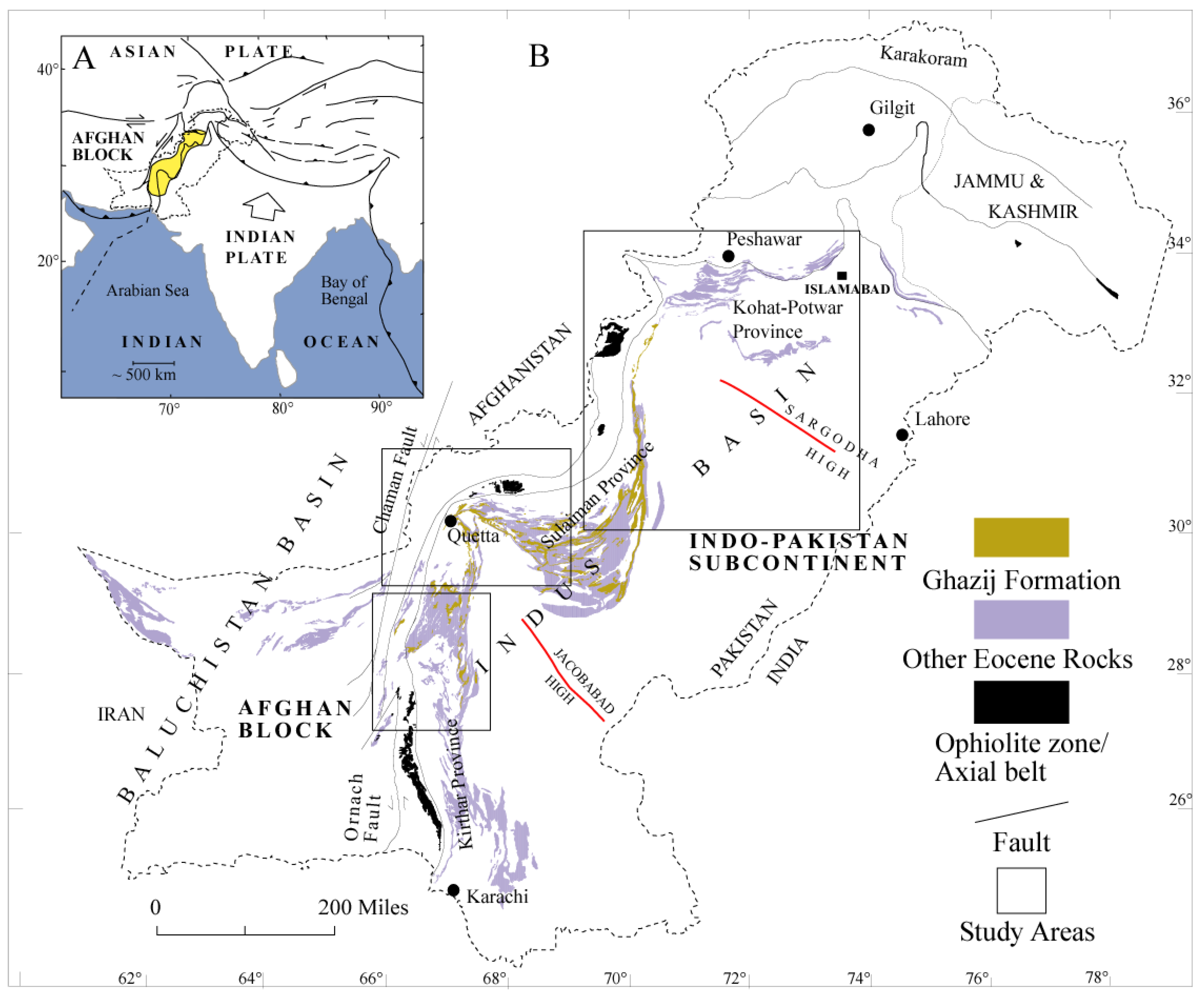
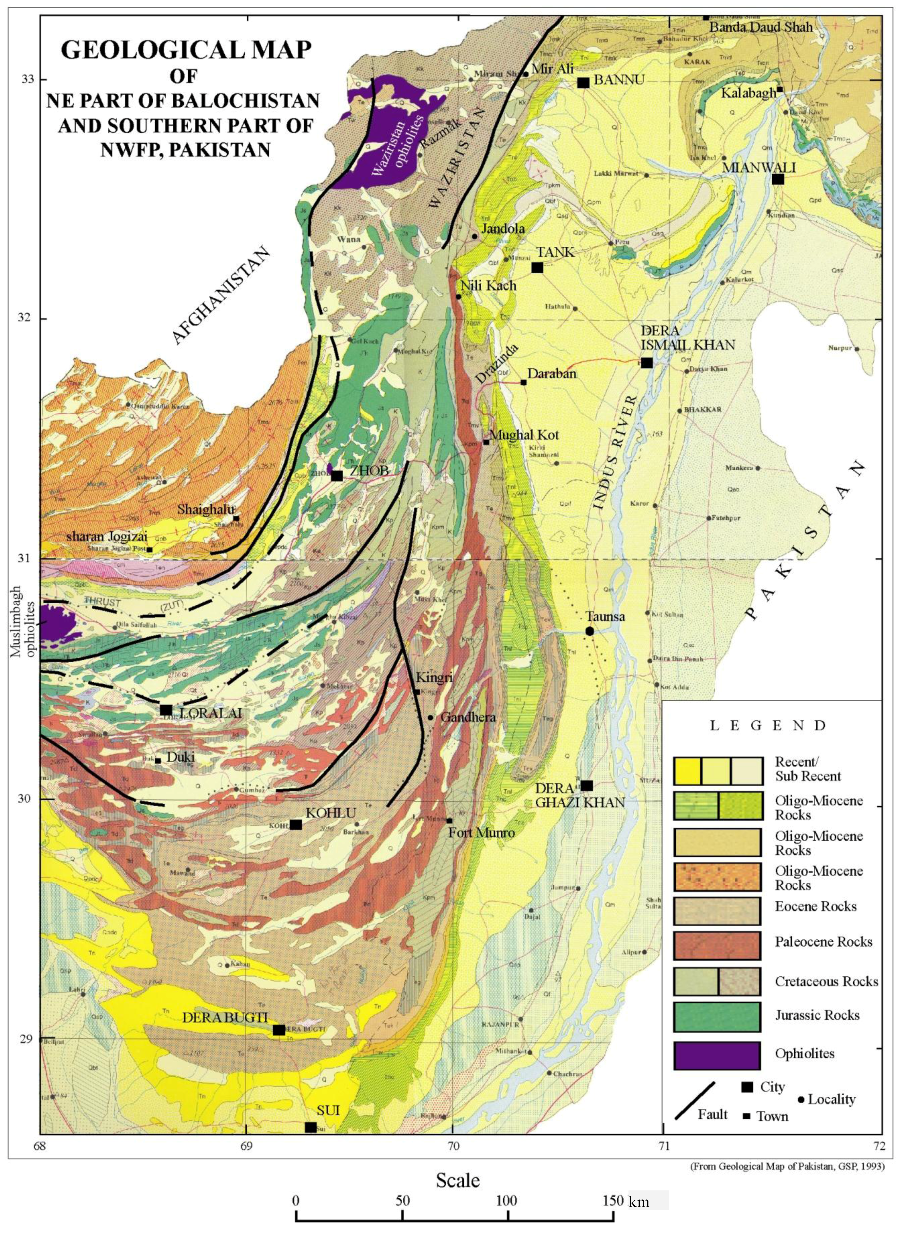
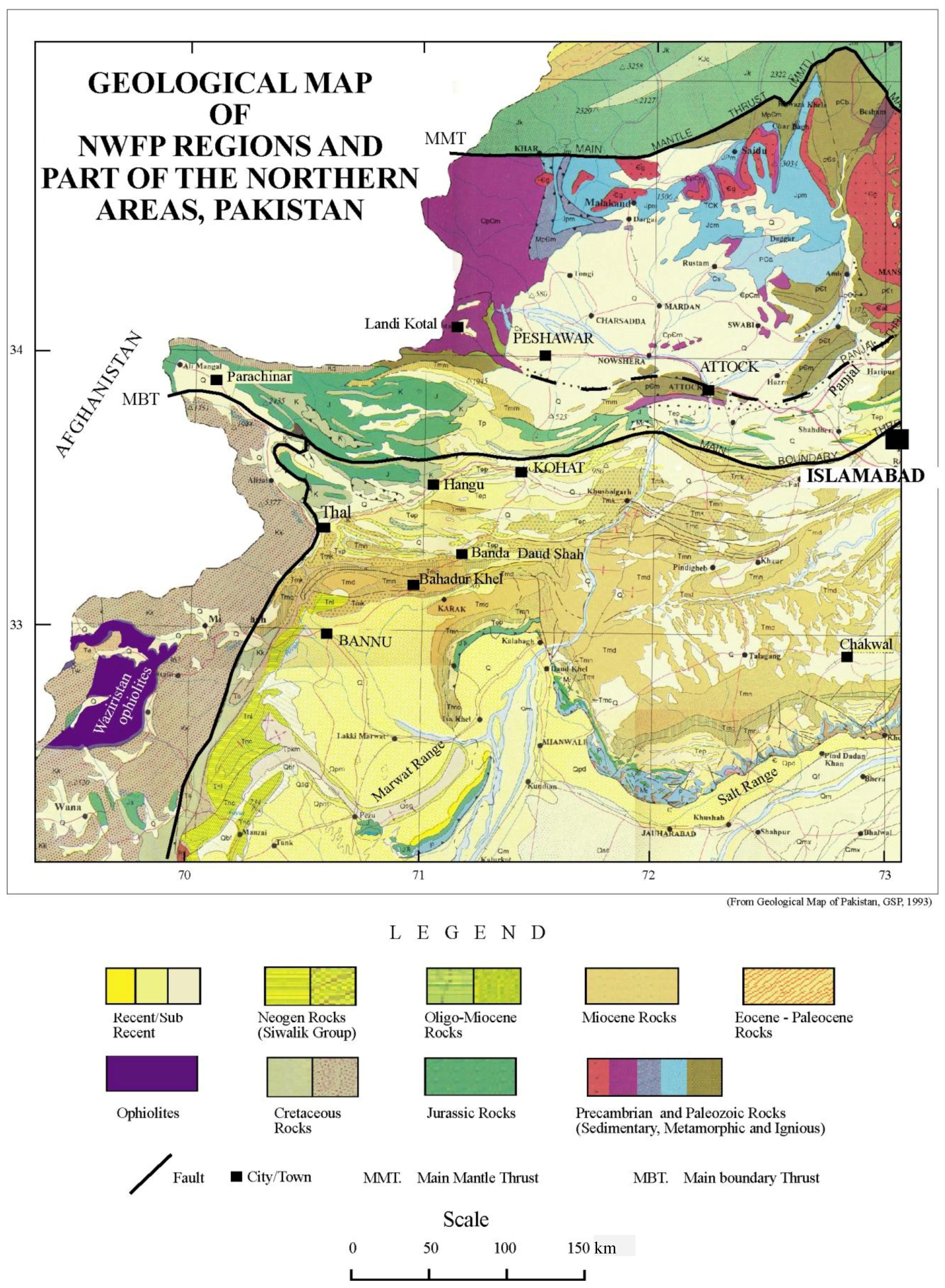
2. Geological Context

The northwestern part of the Indo-Pakistan subcontinent was a passive carbonate platform during the breakup of Gondwanaland and its ensuing northward drift (~Jurassic-Paleocene). These carbonates dominate the lower part of most stratigraphic sections in the field area (Figure 2). Some passive margin clastic rocks are also present (e.g., Cretaceous Sember and Pab Formations) along with isolated volcanic deposits (e.g., Cretaceous Bibai Formation) that are thought to have been emplaced when the carbonate platform passed over the Reunion/Deccan hotspot as the Indian plate moved northward [33,49,51]. By the end of the Paleocene, it is thought that this part of the Indian subcontinent was approximately at, or slightly north of, the equator [26,31,44].
During the late Paleocene and early Eocene, the depositional setting of eastern Balochistan changed dramatically. A topographically positive area developed on the northwest continental margin, creating, for the first time, a northwestern source area for clastic sediments [49]. This tectonically elevated area, named the “axial belt” [52], is now characterized by discontinuous ophiolites (Bela, Muslimbagh, Zhob, Waziristan), associated melanges [52,53,54,55] and transform faults (Chaman-Ornach-Nal fault systems), and represents the present active northwestern border of the Indian plate. The axial belt divides Pakistan into two main sedimentary basins, the Balochistan Basin to the west and the Indus Basin to the east (Figure 1). The Balochistan Basin has a mostly marine history and is part of the Afghan (=Helmand) block. The Indus basin is a generally northeast trending foreland basin bounded by tectonic uplifts to the north and west and the Indian craton to the southeast. Structurally, the Indus Basin is comparatively simple. The Indian shield forms a gentle monocline, which is traversed by a number of basement highs (e.g., Sargodha, Jacobabad highs, Figure 1), extending north-westward for varying distances into uplifted regions. These basement highs divide the Indus Basin into upper, middle, and lower sub-basins from north to south, also referred as Kohat-Potwar, Sulaiman and Kirthar depositional provenances, respectively. Upper Paleocene-lower Eocene rocks are widely exposed in the Indus Basin and exhibit a clear stratigraphic transition from shallow marine facies to continental fluvial facies. The outcrop area of these rocks mimics the western margin of the Indian plate suggesting they are closely associated with, and/or modified by, the collision between Indo-Pakistan and Asia (Figure 1). Probably the best example of these transitional rock units is the lower Eocene Ghazij Formation ([44,49,50,52,56,57,58,59,60,61,62,63,64,65,66,67,68,69,70,71,72,73,74,75,76,77,78,79,80,81,82,83]; see [84] for full review). During the early Eocene, the marginal marine to non-marine Ghazij Formation was deposited on the western side of the Indus Basin, and marine sediments were deposited toward the south and east where a relatively shallow continental sea occupied the basin axis [49]. The Ghazij Formation reaches 3300 m in thickness and covers an area of more than 50,000 km2 of Balochistan and Khyber Pakhtunkhwa Provinces of present-day Pakistan. It forms a classic shallowing-up sequence from shallow marine shales (lower Ghazij), to paralic mudstones, sandstones, and coals (middle Ghazij), to continental fluvial sanstones, locally thick conglomerates, mudstones and paleosol facies (upper Ghazij). It is bounded on the bottom by shelf carbonate limestones of the Paleocene Dungan Formation (or its equivalent), and bounded on the top by the lower Eocene Drug/Baska Formations or middle Eocene Kirthar/Spintangi Formations (Figure 2).
Figure 2. Simplified stratigraphy of both Indus and Balochistan Basins in Pakistan. Modified after [52,85,86,87]. Abbreviations: Congl., Conglomerate; Fm., Formation; Gp., Group; Lst., Limestone; Sh., Shale.
Geosciences 03 00466 g002
Age constraints on the Ghazij Formation are based largely on biostratigraphy since no isotopic ages have been reported from it or related units and only preliminary magnetostratigraphic work has been completed [44]. Foraminifera [52,88,89,90,91,92], marine invertebrates [61,93,94] and vertebrate faunas [44,95,96,97,98,99,100] from within and above the Ghazij Formation constrain its age to be latest Paleocene to early Eocene [95]. The Hunting Survey Corporation [52] collected the oldest fossils in the Ghazij Formation from a few feet above the basal unconformity near Umai and Zawar Kanr villages in the Kach area (see Figure A1, Figure A2, Figure A3 for detailed locations). These faunas suggest a late Paleocene age for the lowest Ghazij Formation in this area. This is further supported by Gibson et al. [91] who reported both Paleocene and Eocene fossils within ~50 m interval above the Dungan Formation at Chapper Rift in the Khost area. These results imply that the Paleocene-Eocene boundary must be contained within the lower Ghazij Formation at some localities. However, the upper strata of the Dungan Group (Siazgi limestone and Sanjawi limestone; [52]) in the Loralai and Duki areas contain fossils of early Eocene age. In view of these observations, the lower members of the Ghazij Formation in some places may correlate with parts of the Dungan Group in others suggesting the formational contact may be diachronous. The contact of Ghazij with the overlying Spintangi limestone also seems to be time-transgressive in a direction away from the Axial Belt. This is strongly indicated by the thinning of Ghazij towards the Marri Bughti Hills and the reciprocal thickening of the Spintangi [52].

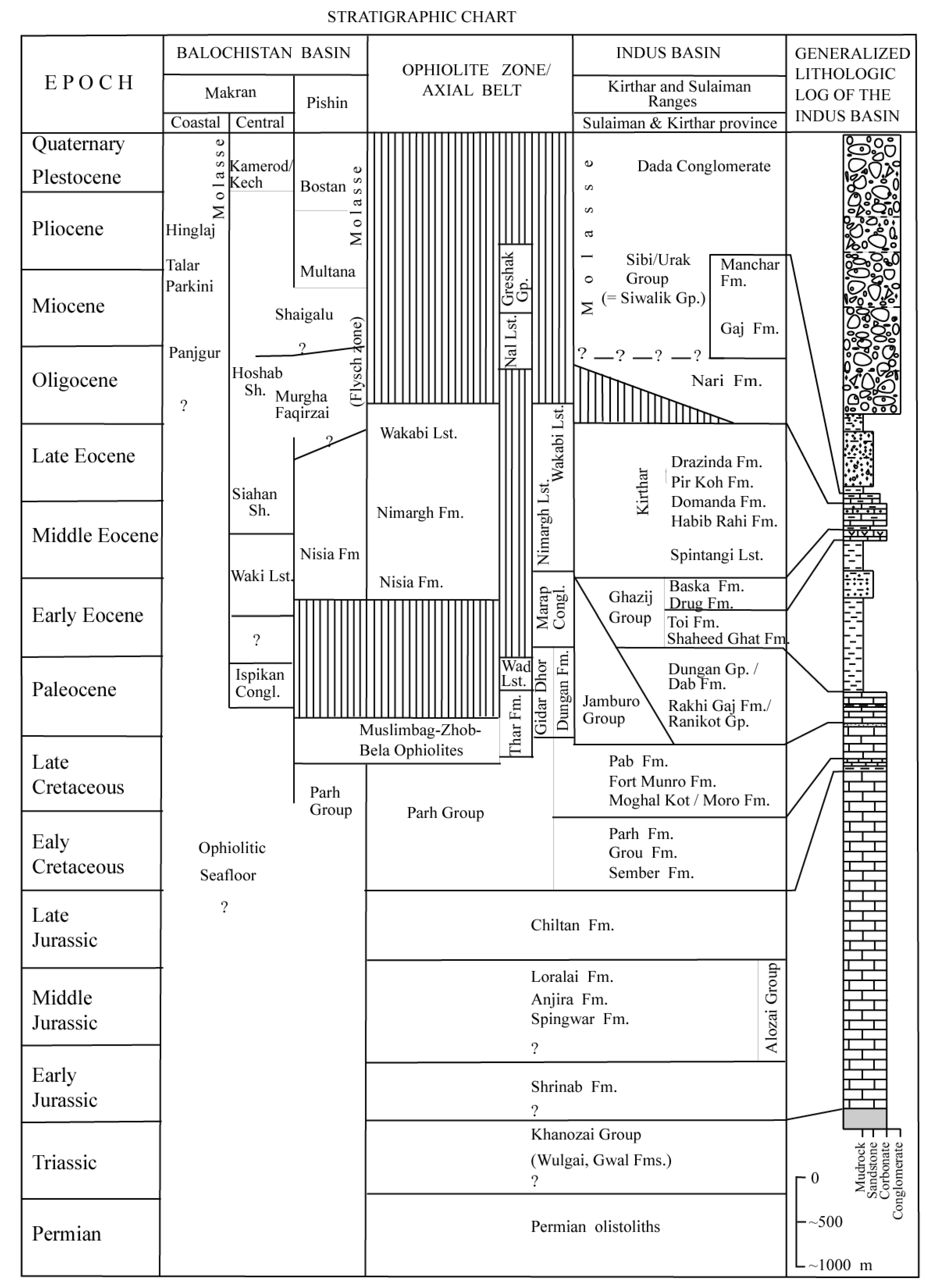
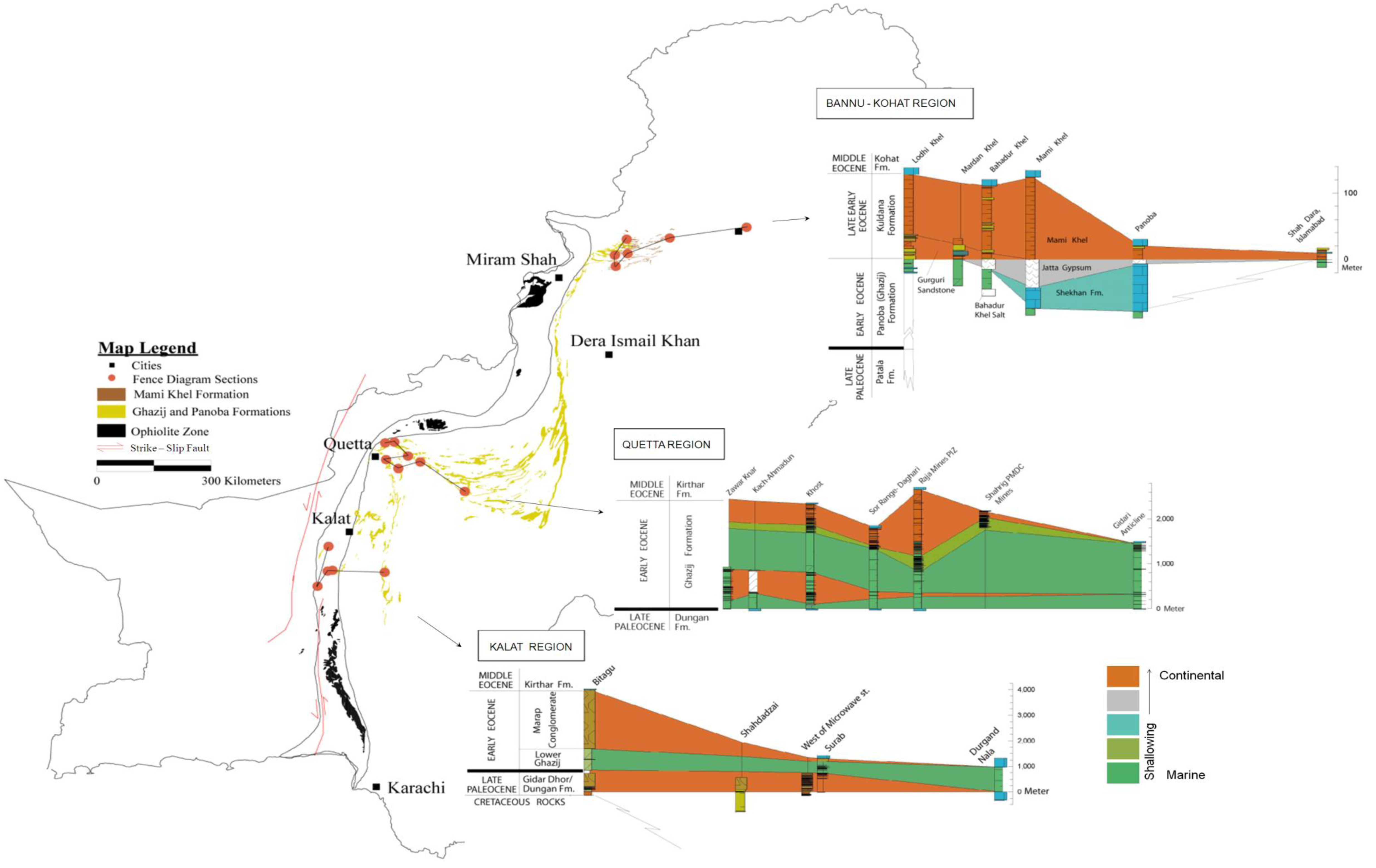
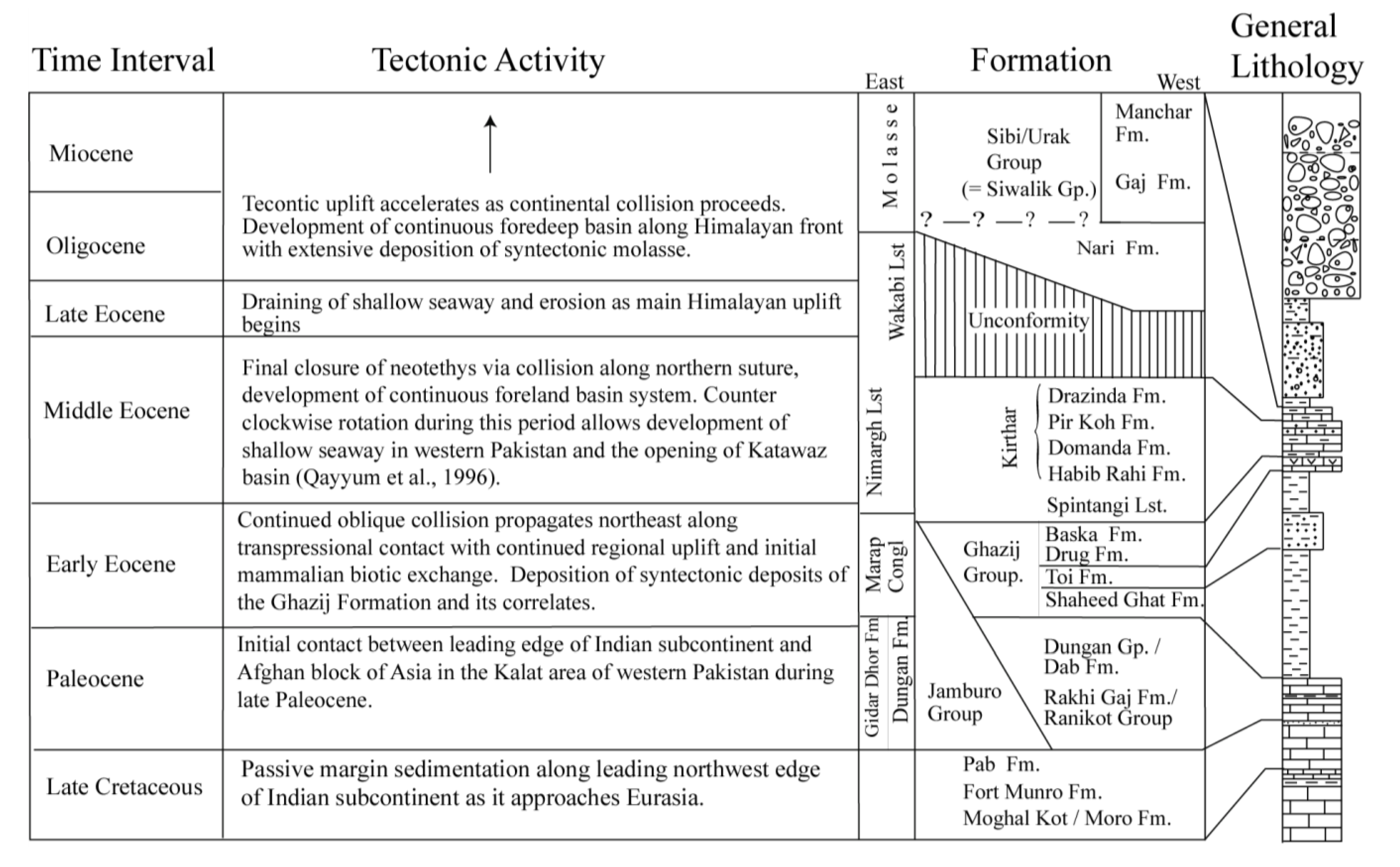
3. Regional Lithostratigraphic Correlations

In order to evaluate more closely the evolution of depositional environments during late Paleocene-early Eocene tectonism in this region as recorded by the Ghazij Formation and other correlative but poorly documented units, a database of over 100 stratigraphic sections was compiled from our own field work and the literature. Despite significant differences in stratigraphic nomenclature between regions, lithogenetic correlations are relatively straightforward between sections. These correlations are used to develop representative fence diagrams for the southwestern, central, and northeastern parts of the field area that, in turn, can be used to interpret the timing and geometry of regional tectonism. In general, the Paleocene to lower Eocene stratigraphic succession throughout the field area is characterized by a shallowing upward sequence with course clastic facies in the west grading to fine-grained clastic and carbonate facies in the east. However, the timing of these facies transitions gets progressively younger toward the northeast, indicating that the onset of tectonism was time-transgressive.

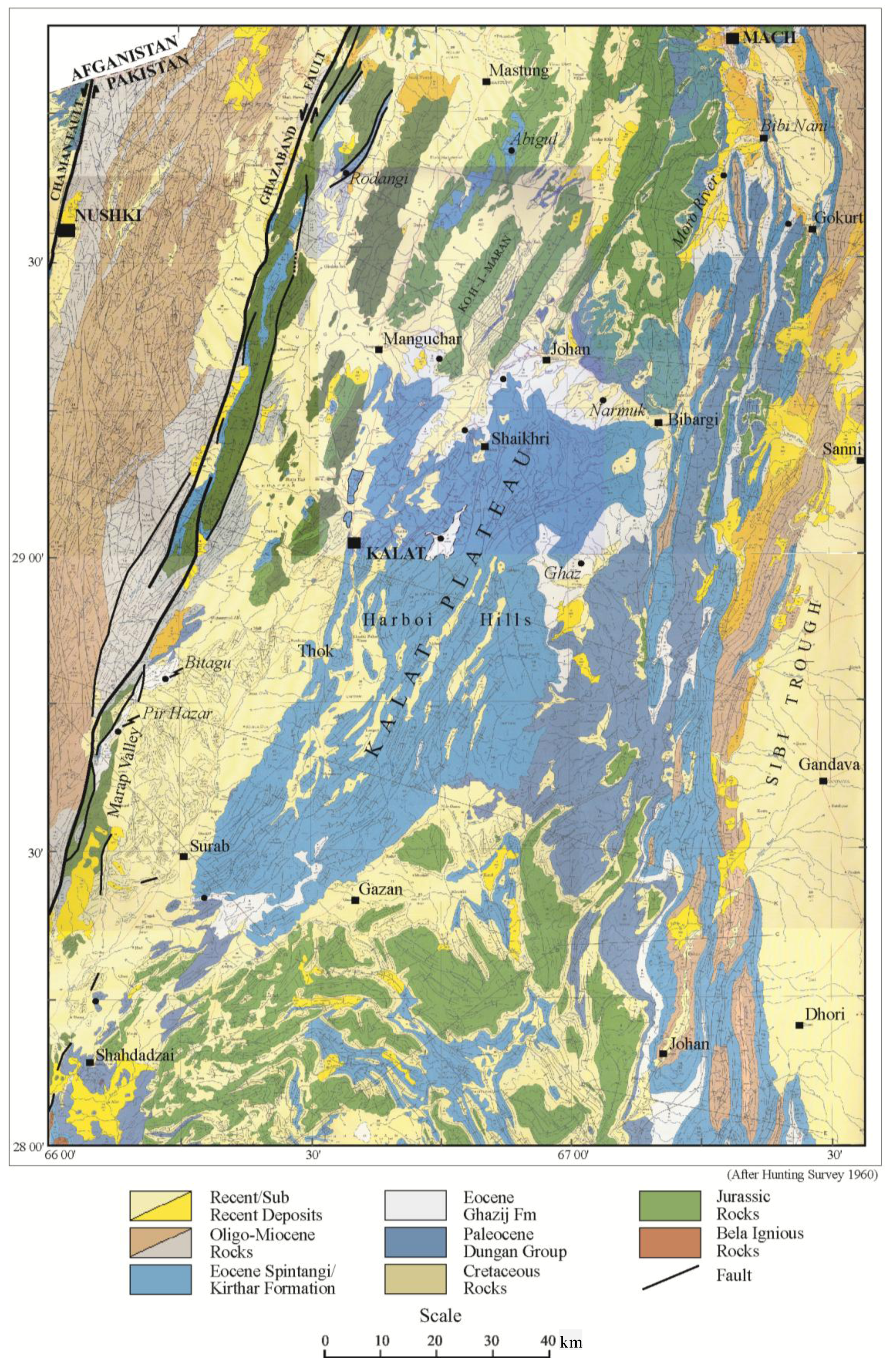
3.1. Southwestern Region of Study Area

Conglomerate is the most dominant and significant upper Paleocene-lower Eocene lithofacies in the southwestern portion of the study area. Near the city of Kalat, it is known as the Marap Conglomerate (Figure A1, [52]). South of Kalat, similar types of conglomerates are reported from the axial belt and are named the Gawanick Conglomerate. Near the village of Marap at the Bitagu locality, ~900 m of partially covered yellowish gray to brownish gray mudrock interbedded with subordinate conglomerate and sandstone beds separates a lower ~650 m thick conglomerate from an upper ~2300 m thick massive conglomerate (Figure 3, Figure A1). Eastward, the middle mudrock facies correlates to the lower Ghazij and the upper conglomerate facies correlates to both the middle and upper parts of the Ghazij Formation (Figure 3). Northward, we correlate the lower conglomerate facies to conglomerate facies in the upper part of the Paleocene-lower Eocene Gidar Dhor Formation, and to pebbly conglomerates in the Kach area near Quetta (see Figure A1 for detailed locations).
In the southern part of the Marap valley, both the lower conglomerate and the mudstone interval that divides the conglomerate into lower and upper are missing due to erosion or a faulted contact. Here, the upper conglomerate facies unconformably rests directly on Mesozoic rocks. At Pir Hazar in the axial belt, the unconformity is observed about 75 m below Marap conglomerate. Here, the interval between this unconformity and the base of the Marap Conglomerate represents the Gidar Dhor Formation (although it was mapped as Parh Group by [52]) and is similar to the base of Gidar Dhor to the south at Shahdadzai. The lower part of the Gidar Dhor is Paleocene in age based on foraminiferal biostratigraphy and its superpositional relationship with the overlying Ghazij Formation [52]. The unconformity at Pir Hazar is represented by a ~2.50 m thick zone of deeply weathered, highly bioturbated, friable, quartz-rich shoreface sandstone that contains bioturbated sandy clay at its top. The base of the sandstone and the sequence below the unconformity bed is covered making it difficult to determine whether the unconformity is between Cretaceous rocks and Gidar Dhor Formation or within the Paleocene Gidar Dhor Formation itself. Either way, it indicates that the western margin of the Indian continent, which was part of a carbonate shelf prior to deposition of the Gidar Dhor, was considerably uplifted by late Paleocene time [32].
In general, the conglomerate sequence in the southwestern part of the study area grades into sandstone, shale and limestone facies to the east, north-northeast and south-southeast of the Kalat plateau (Figure 3). These facies have been mapped as different formations (Gidar Dhor and Rodangi Formations in the axial belt, Karkh and Ghazij Formations east of the axial belt; [52]) but seem to represent parts of a genetically integrated deltaic fan complex. In the area around Johan, the lower conglomerate corresponds to a transition from thin to medium bedded limestone and shale to chaotically bedded limestone pseudo-conglomerate (uppermost part of the Karkh group of [52]). This upper chaotic interval, which is >30 m thick in this area, includes massive paleo-slump blocks of limestone (block size ranges up to 15 m × 30 m) intercalated between normally bedded gray green shale and crumbly sandstone. The upper conglomerate thins to the east as well, with thicknesses ranging from 90 to 625 m in different parts of the Kalat plateau. As the upper conglomerate thins, it interfingers vertically and laterally into the middle and upper parts of the Ghazij Formation (Figure 3). As with the lower conglomerate sequence, this upper conglomerate facies reflects the geometry of a deltaic fan deposit with large lateral thickness variations representing internal local sub-divisions of the fan. Clearly, the presence of such well developed deltaic fans of synorogenic sediment indicates a significant period of tectonism along the northwest margin of the Indian subcontinent starting in the late Paleocene in this area.
Figure 3. Map of Eocene Ghazij, Panoba, and Mami Khel (=Kuldana) Formations with sites of measured stratigraphic sections that are used in adjacent fence diagrams. Fence diagrams show that coarser continental facies generally thin toward the east/southeast creating well preserved wedges of syntectonic clastic detritus (red). The onset of this syntectonic continental sedimentation is oldest in the southwest (Kalat region), where it begins before the Paleocene-Eocene boundary, and is youngest in the northeast (Bannu-Kohat region), where it occurs in the later part of the early Eocene.
Geosciences 03 00466 g003

3.2. Central Region of Study Area

In the central part of the study area near Quetta (Figure 3, see Figure A2 for detailed locations), two pulses of conglomeratic deposits are also recognized although they are much thinner and more localized than in the Kalat region to the south. The upper conglomerate is at the base of the upper Ghazij Formation in this area, and is commonly known as “Ghazij conglomerate”. The lower one is at the base of the lower Ghazij in the area around Kach and is here called the “Kach conglomerate”. Outcrop exposures of the Ghazij conglomerate have limited lateral extent and are confined to geographically isolated bodies (e.g., Sor Range-Daghari and Shahrig-Harnai coalfields, western limb of the Waro Jhal syncline in the area south of Mach; Figure 3). The geographically isolated conglomerate bodies that form the base of the upper Ghazij in these areas, range from 4 to 25 m in thickness, and represent localized conglomerate fan deposits. They tend to thin towards the south and east, grading into coarse sandstones. The Kach Conglomerate (conglomerate at base of lower Ghazij) and its distal pebbly sandstone facies are located primarily in the Kach and Khost-Shahrig areas, however it is faulted in the Kach area (Figure A2).
The paralic middle Ghazij facies (sandstones, coals, carbonaceous shales) are relatively thin in the westernmost part of the Quetta region (minimum thickness = 16 m; [49]). The middle Ghazij attains a maximum thickness of about 500 m to the southeast at Pir Ismail Ziarat and Mach (Figure 3, Figure A2). The presence of such a thin middle Ghazij in the west compared to its average regional thickness is probably due to the presence of conglomerate facies at the base of the upper Ghazij that may have removed a considerable amount of middle Ghazij from this area. Sandstone bodies in the middle Ghazij of this area vary in thickness and composition considerably. East of Quetta in Khost and Shahrig, thick (20 m) sandstone bodies containing rip-up clasts of mud, cross-stratification, and internal erosional surfaces indicate a high-energy fluvial environment of deposition. These high energy deposits grade into lower energy, thinner, finer grained, and more calcareous sandstone bodies to the south at Pir Ismail Ziarat and Mach. This spatial distribution of thickness in the middle Ghazij Formation and its sandstone facies suggests that the Ghazij delta was accumulating at its fastest rate in the region between the Khost and Pir Ismail Ziarat with a transition to progressively deeper water conditions to the east and south.
The upper Ghazij of the Quetta region is characterized by continental fluvial facies including paleosols and interbedded channel sandstones. In general, the upper Ghazij follows the same thickening and thinning pattern as for the middle Ghazi in this region, with thick deposits of the upper Ghazij (more than 800 m) present in Pir Ismail Ziarat that thin towards the south and southeast in Mach and Harnai (Figure 3, Figure A2). Fossil mammals have been recovered from both the middle and upper Ghazij Formation in this part of the field area [44,95,96,97,98,99,100].
As in the southern part of the field area near Kalat, the axial belt in the central part of the field area around Quetta is also characterized by an unconformable zone separating underlying upper Cretaceous-lower Paleocene rocks from the overlying upper Paleocene-lower Eocene rocks. For instance, an unconformity marked by a sandstone unit similar to what was observed at this interval in the Kalat area has been observed at Brewery Gorge ~8 km west of Quetta between the Paleocene Brewery limestone and underlying Cretaceous rocks [101]. An unconformity also exists at this level in the Quetta valley, ~6 km northeast of Baleli Railway Station where the Ghazij unconformably lies on lower strata of the Cretacous Parh Group [52]. In this case, the unconformity is characterized by a weathered pseudo-conglomerate (0.20 m thick) consisting of lateritic ocher and limestone containing Paleocene foraminifera. Other observations suggest that the pseudo-conglomerate at the base of the unconformity in the Quetta valley is present on a regional scale. A similar pseudo-conglomerate bed is reported from the Dungan hills (southeast of Harnai) by Oldham [56] and observed in the Mach area at the base of the lower Ghazij, where it is more than a meter thick and very localized in its lateral extent. It is present as isolated limestone slumped blocks in the Johan area (Figure A1) at about the same stratigraphic level as in Mach. Also, it is observed in the Waziristan area (northeast of Mir Ali on the road to Thal; Figure A3, Figure A4) at the base of a thin variegated shale and sandstone sequence where it is mapped as Paleocene Patala Formation by Meissner et al. [102,103]. The regional presence of a weathered unconformity between lower Eocene rocks and underlying Paleocene or Cretaceous rocks along the axial belt represents another strong piece of evidence that collision tectonics had begun in this region by upper Paleocene time.

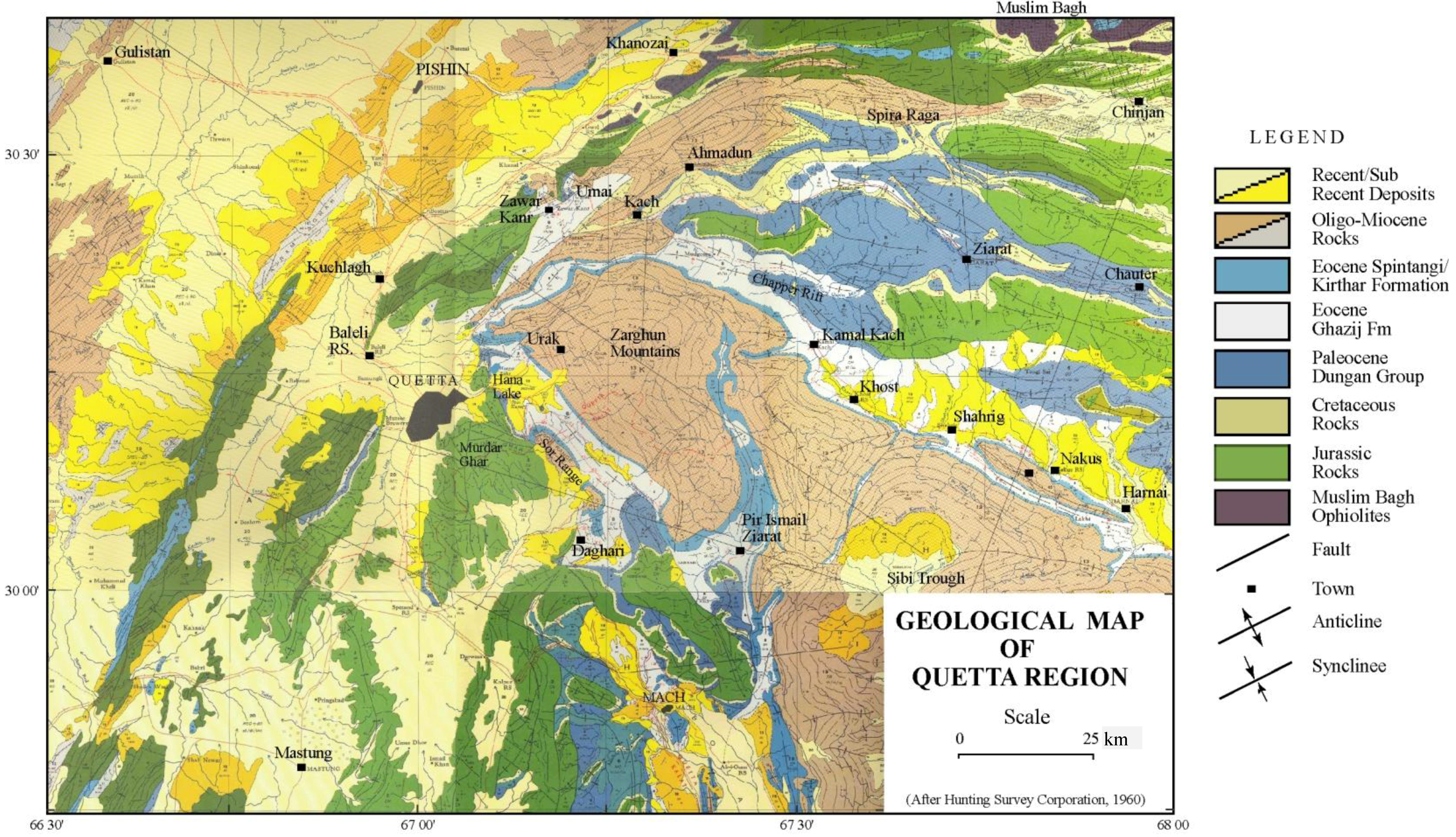
3.3. Northeastern Region of Study Area

The upper Paleocene-lower Eocene deposits of the northeastern part of the study area in the Loralai and Dera Ismail Khan (D.I. Khan) regions exhibit only one recognizable pulse of continental sedimentation that occurs in the later part of the early Eocene (Figure 3, see Figure A3, Figure A4 for detailed locations). It is best represented by the upper Ghazij Formation in the Kingri (780 m) and Mughal Kot areas (1372 m). The upper Ghazij in the Kingri area is characterized by abundant multistory sandstone bodies (up to 12 m thick) intercalated with 5–10 m thick red variegated mudstone intervals. The sandstone bodies often contain thick lag deposits (0.50–3.00 m) at their base. Mammal fossils in the area were collected from sandstone bodies located in the lower half and near the top of the upper Ghazij Formation [44,96,98,99,100]. The upper Ghazij Formation at Mughal Kot and Drazinda contains thick red mudstone intervals with lesser amounts of sandstone. Most sandstone bodies at Mughal Kot are thick, tabular channels, whereas, north of Mughal Kot in Drazinda the sandstone bodies have a more sheet-like geometry, are relatively thin, highly calcareous, bioturbated and contain small-scale cross-stratification. These sandstone bodies are generally intercalated with less mature paleosol intervals of red to reddish brown, maroon, purple and yellowish brown to yellowish gray color that reflect different degrees of hydromorphy. These red mudrocks of the Drazinda area thin gradually northeastward toward Waziristan (Nili Kach and Jandola areas) and east of the axial belt they merge vertically into red purple and dark maroon mudrocks of the Baska Formation and laterally (eastward) to green marine shales of the lower Ghazij (Figure 3, Figure A3).
The Baska and the middle and upper Ghazij Formation lose their identities in Waziristan somewhere between Jandola and Mir Ali (Figure A3). Here these units all transition into the green marine shales of the lower Ghazij and laterally equivalent Panoba shale [103] except in the uppermost part that contains rarely exposed very thin red shale (<1–4 m thick) and conglomeratic sandstone. This thin zone of continental facies lies a few meters below the Kohat Formation (lateral equivalent to Spintangi/Kirthar Formation) and represents the same stratigraphic level as the Baska Formation toward the south in D.I. Khan region and the Mami Khel Clay facies of the upper Kuldana Formation toward the north in the Kohat region (Lodhi Khel and Banda Daud Shah area; Figure A4). Whereas the Mir Ali area preserves the distal part of the Ghazij clastic wedges in this region, the proximal facies of the wedge is preserved towards the west near the Waziristan ophiolite (Figure 3, Figure A3). The intermediate lithologic part of the sequence that links the Waziristan sections with the Baska and Kuldana Formations has been eroded away by later tectonism in the Kurram-Waziristan part of the axial belt. However, intertonguing is preserved in faulted sequence near Mir Ali in North Waziristan. The sequence in this area is comprised of a thin conglomerate bed (0.45 m thick) at the base, which lies ~84 m below the Kohat Limestone, and a thick sequence of greenish gray shale that contains light purple, light yellowish to grayish purple shale (~4 m thick) in the upper middle part and about a meter thick red shale near the top. The Mir Ali conglomerate stratigraphically corresponds to the basal sandstones of the Baska Formation and seems equivalent to conglomeratic sandstone facies of the lower Kuldana Formation (Gurguri Sandstone) in the Kohat area. The green and red shale horizon at Mir Ali on top of the conglomerate corresponds stratigraphically to the upper gypsum and limestone part of the Baska Formation of D.I. Khan region in the south and to red mudrock facies of the Mami Khel clays of upper Kuldana Formation in the Kohat area.
The clastic wedge represented by the upper Ghazij and Kuldana Formations in the northeastern part of the study area was deposited due to tectonic deformation that uplifted Waziristan and the west-northwestern part of the Kohat area of the Indian plate during the late early Eocene. Prior to the late early Eocene, the Kohat area was part of the Indian shelf as indicated by lower Eocene limestone and marine shale deposits in the area (Shekhan Limetone, lower Ghazij, and Panoba shale deposits). The Kohat part of the Indian shelf then uplifted, forming continental environments during late early and early middle Eocene time (deposition of Kuldana Formation; [104]). The shallowing-up lithologic sequence in the area represents the youngest continental deposits in the region that are associated with this early Paleogene stage of collision. The coarser syntectonic sediment (conglomerate near Mir Ali and coarse sandstone facies of the Gurguri sandstone) was deposited in the west-northwest, proximal to the uplifted collision belt, whereas fine sand and mudstones (Mami Khel facies) were deposited basin-ward towards the east (Banda Daud Shah area). Correlation of the uppermost Ghazij sandstone facies at Mughal Kot, Kingri and Gandhera with the Gurguri sandstone facies of the Kuldana Formation is supported by the presence of similar mammalian faunas [98,105].

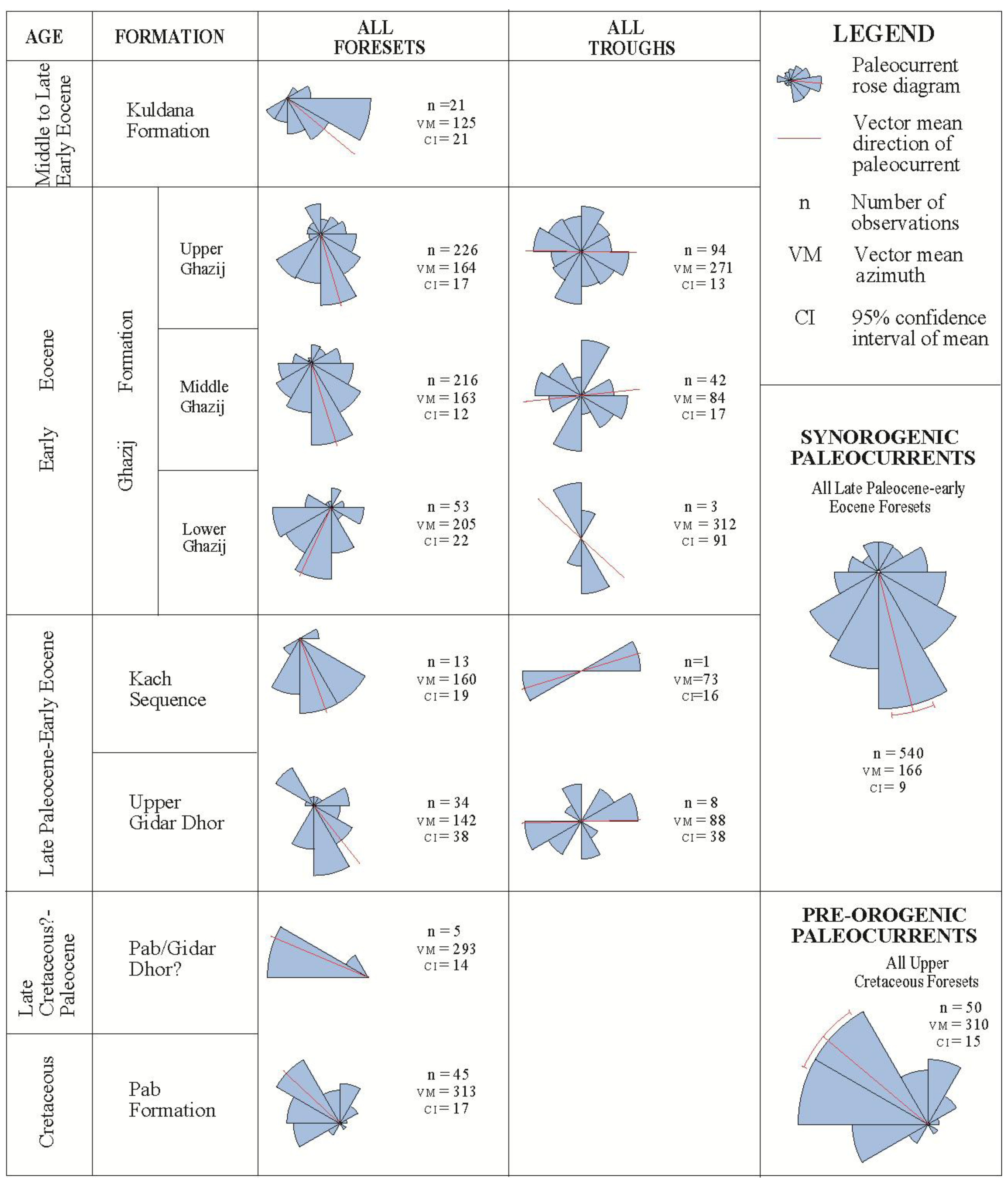
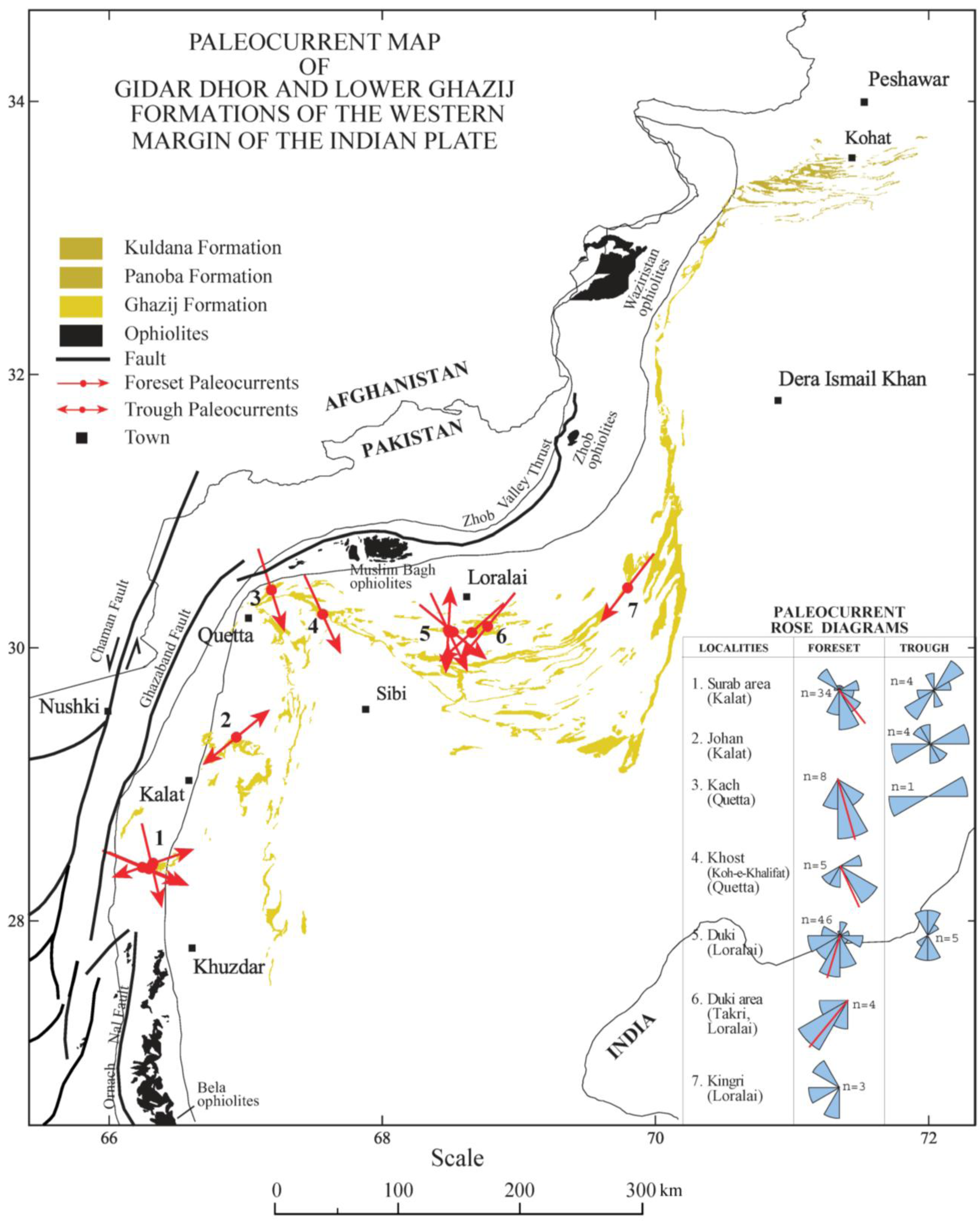
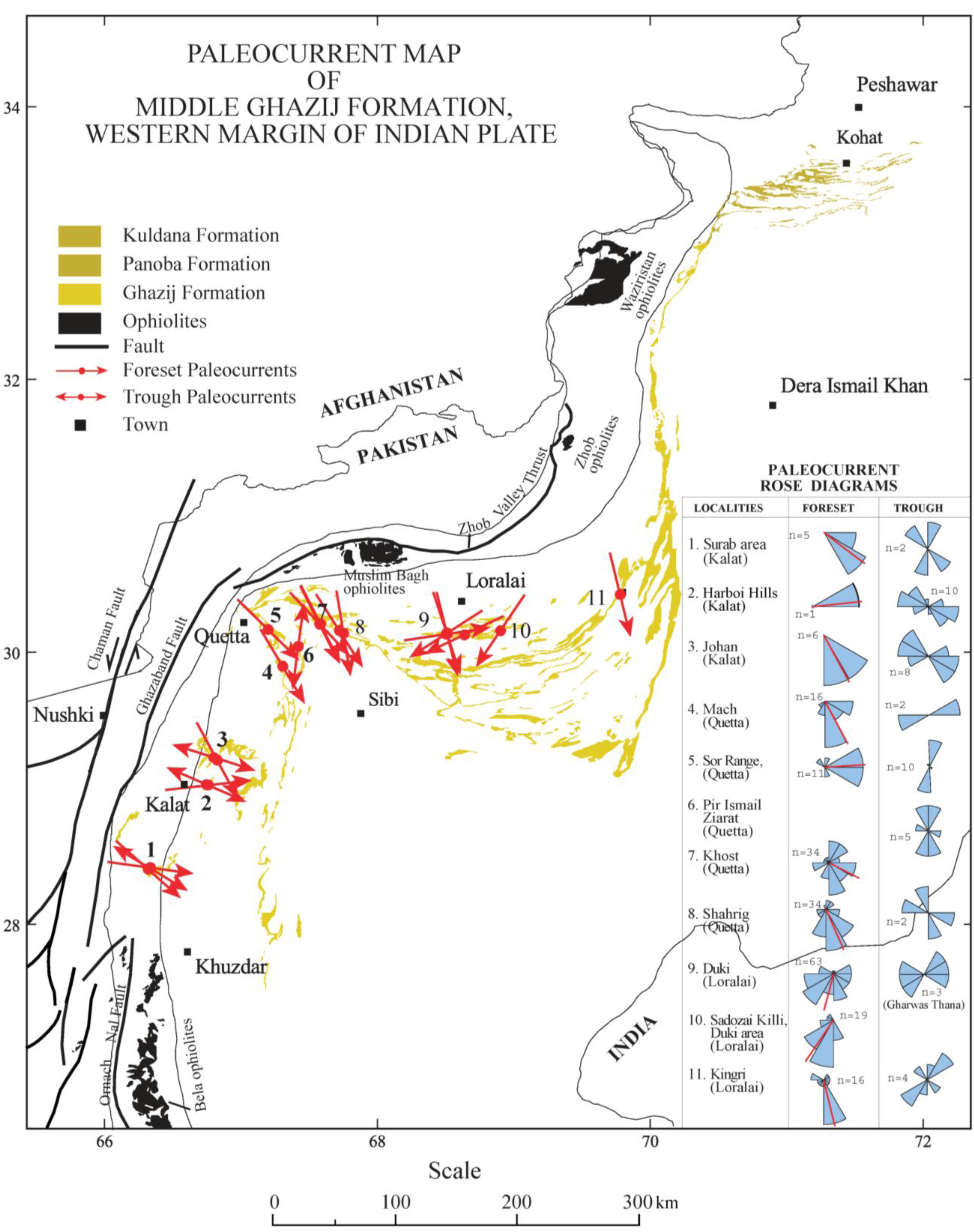
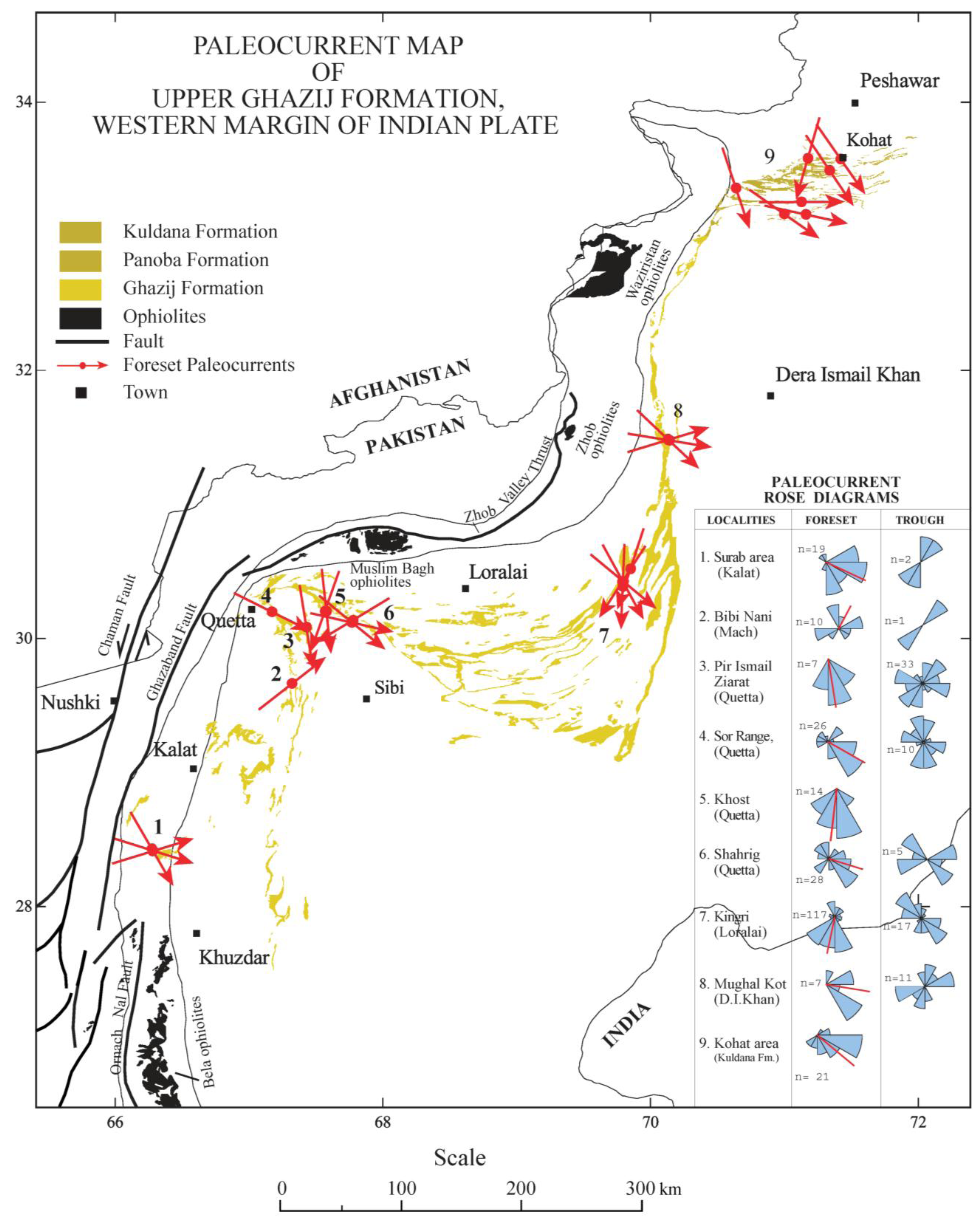
4. Paleocurrent Directions

Paleocurrent data from upper Cretaceous to Eocene sandstone bodies in the study area were collected in order to establish flow direction during this period of significant change in depositional environments. Trough cross beds and tabular cross beds are the most common sedimentary structures that preserve paleocurrent information in the study area and are used here for the purpose of estimation of flow directions. Paleocurrent measurements were collected from sandstone outcrops that preserve three-dimensional exposures in order to constrain the direction of maximum dip for foresets and troughs as precisely as possible. At least three separate measurements of current direction were collected at each sandstone outcrop/site. Those sites where apparent dip of foresets was the only information available, two apparent dips were measured on each cross bed in order to define the inclined plane by stereographic projection. At places where the trough axis could not be measured directly, it was constrained by measuring the trough limbs [106]. Most Ghazij outcrops in the region are also structurally inclined, so stereographic projection was used to perform horizontal axis tectonic corrections. It is also likely that the region has undergone some amount of vertical axis rotation, which may also affect cross-bed measurements. Although this could not be accounted for, it should not significantly affect the interpretation of results since measurements in each of the sub-regions of the field area will have been similarly rotated, so observed stratigraphic changes in flow directions should indicate real changes on topographic gradients. About 750 paleocurrent measurements of foresets and trough cross beds from sandstones were recorded over an area that extended from Kalat in the south to Mughal Kot in the north [Figure 4, Figure A5, Figure A6, Figure A7, Table S1 (Table S1 can be found in the supplementary online material)].
Cretaceous sedimentary rocks in the study area represent pre-collision deposits of the western margin of the Indian plate. These rocks are interpreted to have been deposited on the westward sloping shelf of the Indian plate during its northward flight after separating from Gondwana [107]. The Cretaceous rocks dominantly consist of shelf carbonate deposits (e.g., Parh Formation) or near-shore clastic deposits (Mughal Kot Formation); however, channel deposits are present in the upper Cretaceous Pab Formation and contain abundant sedimentary structures. A total of 50 foreset paleocurrent measurements were recorded from the Pab sandstone at Hingulun Nala (Loralai region) and stratigraphically equivalent sandstones from Bitagu (Kalat region). The paleocurrent rose diagram shows a dispersed but unimodal current pattern (Figure 4). The mean of the foreset values indicates dominant flow was toward the northwest in both locations [313° ± 17° (± 95%) at Hingulun Nala and 293° ± 14° at Bigatu]. These results are consistent with previous research from the Pab Formation in Rakhi Nala [108], the eastern Sulaiman Range [109], and the Kirthar Range [110].
Paleocurrent flow directions were also collected from the upper Paleocene and lower Eocene rocks of the Gidar Dhor Formation, and lower, middle and upper parts of the Ghazij Formation. A total of 42 foreset and trough paleocurrents were recorded in the Kalat region from the Gidor Dhor formation (Figure 4; Table S1). The paleocurrent measurements indicate a moderately dispersed southeastward paleoflow varying towards the northeast and southwest. The vector mean of foresets show dominant southeastward paleoflow toward 142° (±38°), whereas the troughs indicate west-east axis of transport (268°–88°) in the Surab and Johan areas. Although paleocurrent measurements for this interval are relatively poorly sampled, the dominant paleoflow is in the southeastward direction throughout this time in the region (Figure 4).
Paleocurrent data from the lower part of the Ghazij Formation were collected from Loralai and Kach regions. A total of 56 foreset and trough paleocurrent measurements were recorded from sandstone bodies present in the middle of the lower Ghazij Formation in the Duki and Kingri areas (Figure 4, Figure A5; Table S1). Paleocurrents here show unimodal highly dispersed southwestward paleoflow varying to the southeast. The mean of the foreset values shows dominant paleoflow at 205° towards the southwest, whereas trough values indicate a northwest-southeast axis of transport (132°–312°; Figure 4). These measurements are from 12 different sites and indicate that the principle flow directions of the rivers were consistently toward the south in this area (Figure 4).
Figure 4. Summary of paleocurrents by formation shows dominant east-southeastward paleoflow during late Paleocene-early Eocene time. Prior to the Paleocene, the dominant paleoflow of sediments was to the west and northwest. This indicates a change in dispersal path of sediments and suggests a slope reversal of the Cretaceous shelf of the Indo-Pakistan subcontinent during late Paleocene-early Eocene time (see also Table S1 and Figure A5 Figure A6, Figure A7).
Geosciences 03 00466 g004
A total of 258 foreset and trough paleocurrent measurements were recorded from the middle part of the Ghazij Formation at various localities of the Kalat, Quetta, and Loralai regions (Table S1). The paleocurrents here show dominant south-southeastward flow with variation towards the east-northeast and south-southwest (Figure 4, Figure A6). Overall, in the area south of the Quetta syntaxis, the vector mean paleoflow directions of both Kalat and Quetta regions indicate a very consistent southeastward paleoflow direction with local variations toward the northeast, east and southwest. Paleocurrents from the Loralai region to the northeast of Quetta syntaxis show dominant southwest paleoflow. The overall mean current direction from middle Ghazij foreset beds is 163° (±12°) and the troughs indicate an axis of transport trending 264°–84°. The highly dispersed but unimodal current directions of the middle Ghazij may represent a braided/distributary flow pattern of a deltaic environment with local and regional differences in the flow directions and/or the influence of vertical axis rotations associated with the Quetta syntaxis.
Paleocurrent data from the upper part of the Ghazij Formation were also collected at various localities of the Kalat, Quetta, Loralai and Dera Ismail Khan regions. About 320 foreset and trough paleocurrents were recorded from this part of the formation (Table S1) and show the same south southeastward flow pattern as the middle part of the Ghazij (Figure 4). The directional variance of the upper Ghazij decreases slightly as compared to the middle Ghazij. The mean azimuth of foreset current directions is 164° (±17°) whereas the mean azimuth of trough directions indicates a west-east axis of transport (271°–91°, Figure 4).
Taken all together, these paleocurrent data show quite clearly that paleoflow was mainly towards the west and northwest during Cretaceous time whereas during late Paleocene-early Eocene time, they reversed and the paleoflow direction was dominantly towards the east and southeast (Figure 4). These changes in paleoflow direction support the sedimentary evidence for tectonic uplift of the Cretaceous shelf during late Paleocene-early Eocene time and are consistent with a reversal in the regional depositional slope at this time.

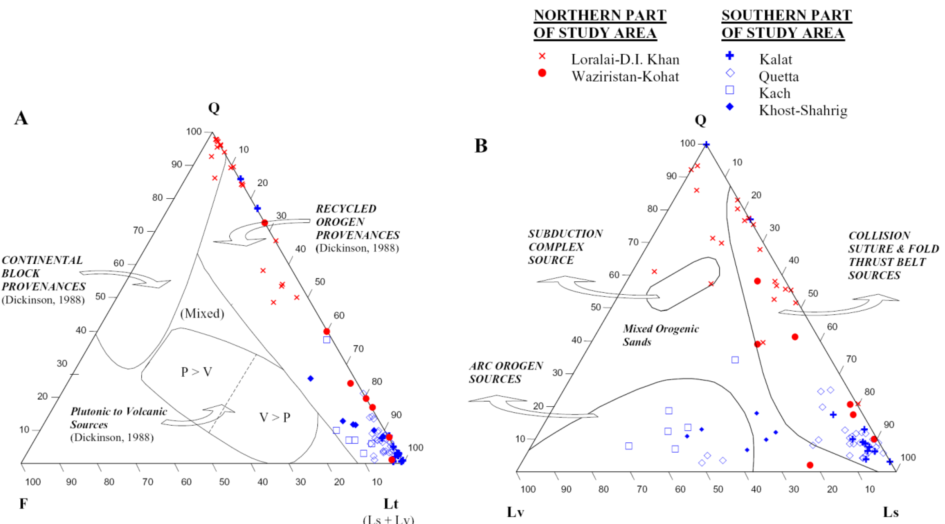
5. Sediment Provenance

The goal of provenance studies is to determine the composition of the source area from which clastic deposits were derived and to characterize where rocks have been removed by erosion and deposited in adjacent basins. Provenance information of this type can be used to help reconstruct original basin configuration, regional paleogeography, paleotectonic setting, and the uplift history of source areas [111,112,113,114,115]. By evaluating provenance changes through time, it is also possible to characterize local and regional crustal evolution of source areas [111]. Previous petrographic studies from the study area show considerable geographic variation in sandstone compositions [49,80,81,83,116]. Here we report new petrographic results from the Ghazij and correlative units to better understand the spatial variability of sandstone compositions and more fully reconstruct the tectonic setting of the western Himalayan suture zone during the early Paleogene.
A total of 82 representative sandstone samples were analyzed from the Ghazij Formation and related rock units including Gidar Dhor and Kuldana Formations for provenance analysis. Collected sandstone samples cover an area of the western margin of the Indian plate that extends from Kalat in the south to Kohat in the north (Figure 1). Standard thin section slides were prepared and stained for K-feldspar and calcite. All thin sections of sandstones were examined under a petrographic microscope and each grain encountered under the cross hairs of the microscope was identified, counted and recorded using an electronic point counter that automatically advanced the stage a given distance. A total of 450 framework grains on each thin section slide were counted and recorded in this way. Grains that were altered but still identifiable were counted as the original grain. This was common for plagioclase feldspar, which is often partially altered to clay. In these rocks it was sometimes difficult to distinguish between chert, especially the radiolarian type, and devitrified glass rock fragments containing spheroids that look like zeolites or chalcedony. Scanning electron microscope (SEM) analysis on these grains helped by evaluating whether the spherical part is dominated by Si (chert) or whether it also contains Al, Mg, K, Ca, and Fe (glass). For SEM analyses, slides were first coated with a fine-grain conductive layer of carbon. The carbon-coated sample was then left for about 24 h to dry. After carbon coating, the thin sections were observed with an AMRAY 3300 FE (SEMTech, North Billerica, MA, USA) scanning electron microscope (SEM). SEM images of each sample were taken at various magnifications and energy dispersive analysis of X-rays (EDX) for elemental analysis was done on several areas of each sample. For purpose of provenance analysis, the 450 framework detrital grains that were identified and counted in detail on each thin section slide were grouped and categorized into the following standard groups: quartz (polycrystalline, monocrystalline), feldspar (plagioclase, orthoclase) and lithic rock fragments (igneous, sedimentary, and metamorphic). The results were plotted on standard QFL provenance ternary diagrams as outlined by Dickinson [112] and grouped according to region and formation to assess spatial and temporal variation.
Petrographic results show that sandstones from the Ghazij Formation and associated other units in the field area are dominated by rock fragments and quartz grains [Figure 5; Table S2 (Table S2 can be found in the supplementary online material)]. Among the various types of rock fragments, limestone and chert are the most abundant. Volcanic and other igneous rock fragments are typically minor constituents but are abundant and dominant locally at certain stratigraphic levels in Quetta and the Kalat regions. Cement is coarsely crystalline calcite, some of which is ferron calcite, and quartz. The minor compositional constituents identified under microscope and SEM-XRD studies of the sandstones are shown in Table 1.
Table 1. List of rare rock fragments and minerals identified in thin section samples of sandstones examined in this study.
Amphibole?ChloriteGlauconiteRhyolite
ApatiteDaciteIlmanite/LimoniteSerpentine
AragoniteEpidoteMuscoviteSphene
BiotiteFeldsparOlivineWallostonite
ChalcedonyFerron calcitePalagoniteZeolite
ChertVolcanic GlassPyroxene (Augite)Zircon
Although igneous rock fragments are present at many locations, their modal percents are generally low. However, there are a few localities and stratigraphic horizons where igneous rock fragments are abundant. Higher igneous content in Ghazij sandstones is generally observed in those areas which are closest to the axial belt. For instance, sandstones in the Kach area have igneous rock fragment contents of up to 61% with subordinate feldspar, quartz and limestone fragments. Igneous content gradually decreases away from the axial belt towards the east. For instance, middle Ghazij sandstone samples collected near Quetta, which is near the axial belt, have an average igneous content of 15.6% whereas sandstones from the same stratigraphic interval in the more distal Loralai/D.I. Khan area average 6.2% (Table S2). The slightly older Gidor Dor Formation which outcrops in the southwestern part of the study area and the slightly younger Kuldana Formation which outcrops in the northeastern part of the study area were also sampled at various locations. Sandstones from these units mimic the Ghazij sandstone in being dominated by either limestone rock fragments or quartz with subordinate feldspar and igneous rock fragments (Table S2).
Petrographic results are plotted on standard ternary diagrams with overlays of provenance classification [112] to help interpret the late Paleocene-early Eocene tectonic setting of the study area (Figure 5). The QFL (quartz, feldspar, lithic fragment) ternary diagram shows mostly a recycled orogen provenance for the Ghazij, Gider Dhor, and Kuldana Formations. The QLvLs diagram (quartz, igneous rock fragments, and sedimentary rock fragments) shows most samples falling in the collision suture and fold thrust belt provenance with some Gidor Dhor Formation samples from the Quetta and Khost-Sharig regions having an arc orogen source.
Figure 5. Distribution of detrital modes for upper Paleocene-lower Eocene sandstone rocks of the study area are plotted on standard ternary diagrams with overlays of provenance classification [112]. Results show that the Ghazij is dominated by recycled orogen, collision suture and fold thrust belt sources. (A) Standard modal composition of quartz, feldspar and rock fragments (QFL) for sandstone rocks separated by geography; (B) Relative abundance of rock fragment types for sandstone rocks separated by geography (see also Table 1, Table S2). Q, quartz; F, feldspar; Lt, total lithic fragments; Ls, sedimentary lithic fragments; Lv, volcanic lithic fragments.
Geosciences 03 00466 g005
The most striking pattern in these data is the geographic pattern of compositional variability. Sandstones from the southern part of the field area (Quetta, Kalat) are dominated by sedimentary rock fragments (mostly limestone grains). Sandstones from the central area around Kach contain abundant volcanic material. Sandstones from the northern part of the field area (Loralai region) are dominated by quartz (Figure 5). This strong spatial variation in sandstone composition suggests the existence of isolated watersheds that drained local sediment sources without significant mixing by large through-going fluvial systems. The southern limestone- and rock fragment-dominated compositional domain is separated from the northern quartz-dominated compositional domain of the Loralai and D.I. Khan regions by the Quetta syntaxis suggesting that some pre-existing structural feature in this area may have led to subsequent syntaxial folding (Figure 1).
The high percentage of limestone grains in the Ghazij Formation sandstones from the area surrounding and south of Quetta indicates that the local source area was dominated by limestone. There are thousands of meters of Triassic to upper Paleocene carbonates directly below the Ghazij Formation that are extensively exposed as part of the axial belt (Dungan, Parh, Goru, Mughal Kot, Fort Munro, Chiltan, and Shirinab Formations; [52]). These rocks must represent the dominant source rock in the area south of Quetta during the late Paleocene-early Eocene. Some of these units (Parh and Chiltan Formations) also contain chert, which would explain the common presence of chert fragments in the Ghazij and Gidor Dhor Formations in these areas. The high percentage of quartz grains in the northeastern areas of Loralai, and D.I. Khan is interpreted to be derived from the quartz sandstones of the Pab Formation. There is no other source rock known to have been present in the region that could provide enough quartz to the Indus basin during late Paleocene-early Eocene time. The only other possible source that could provide this quantity of quartz to the Indus basin at this time is the Precambrian felsic crystalline rocks which are present to the east of the basin towards the Indian craton. However, the interpreted paleocurrent directions from the Ghazij Formation do not support any easterly source area at this time. The Pab sandstone, about 465 m thick in this area [52], is interpreted to be derived from the Precambrian felsic crystalline rocks during upper Cretaceous time [107]. A Pab source for these Ghazij sandstones is also supported by the rare presence of reworked detrital tourmaline grains in the Ghazij samples from this area, which is considered one of the diagnostic compositional characteristics of the Pab. The Ghazij sandstones from the Loralai and D.I. Khan regions thus show a similar pattern to Ghazij sandstones from south of Quetta in being dominated by grains from immediately underlying Mesozoic sedimentary units.
The igneous rock fragments that dominate the sandstones near Kach and are locally abundant in the Ghazij and upper Gidar Dhor Formations are interpreted to have been derived from the upper Cretaceous Bibai Formation, the Bela volcanic group, and the ophiolites that are intermittently exposed within the axial belt. The Bibai and Bela volcanic rock suites are thought to be associated with hotspot activity and are recognized as alkali basalts [117,118,119,120,121]. They are dominated by amygdaloidal pillow basalts and basaltic volcaniclastic rocks. The igneous grains in the sandstone from the Kach and Quetta regions are mostly altered volcanic rock fragments composed of basalt and volcanic glass and are thus consistent with being sourced from the Bibai and Bela volcanic suites. Some sandstones in the middle part of the Ghazij at Khost-Shahrigh, Pir Ismail Ziarat and Mach are greenish in color probably due to alteration of the volcaniclastics into chloritic clay minerals. These green sandstones are known to increase in thickness towards the west in the Kach area where the Bibai Formation is well exposed. Less commonly present in these areas are mafic/ultramafic grains that are likely derived from ophiolitic rocks currently exposed in the northwestern part of the region (Figure 1). Rare chromite grains in the Quetta region sandstone samples were interpreted to be derived from these ophiolitic complexes as well [49], however sills and dikes present within Triassic carbonate rocks as part of mantle plume activity during the earliest rifting of northwestern margin of Indian plate from the Afro-Arabian plate could explain these observations as well [121,122].
In each case, upper Paleocene-lower Eocene sediments in the field area can be traced to local underlying units of Mesozoic or early Cenozoic age indicating that they represent the initial erosional products of uplift and unroofing along the western margin of the Indian subcontinent. This further supports the interpretation from facies analysis and current direction analysis that the Ghazij and related units represent the sedimentary response to a significant early Paleogene tectonic collision. The overall erosion and unroofing pattern across the field area is also consistent with a time-transgressive initial uplift. Source rocks of the Kalat area were the most deeply eroded and involved detrital limestone grains from Jurassic rocks. Source rocks in the Quetta area are dominantly represented by Cretaceous rock units (mostly Parh, Bibai Formations) and source rocks in the Loralai and D.I. Khan areas are dominantly represented by the upper Cretaceous Pab Formation. This erosional pattern indicates that uplift and erosion of Indian shelf rocks first started in the south along the transpressional margin of the Indian plate as a result of initial collision tectonics and proceeded northward towards the Kohat area.

6. Discussion and Conclusions

Our examination of lower Paleogene sedimentary units in Balochistan and Khyber Pakhtunkhwa Provinces of Pakistan indicate that the process of deformation and uplift of the western margin of the Indian subcontinent was started as early as late Paleocene time (Figure 6). This tectonic uplift along the western margin of the Indian continent is documented by several independent lines of evidence: (1) The Ghazij Formation and related units contain synorogenic sediments in an overall shallowing upward sequence that are interpreted to be part of the earliest deltas formed on the actively uplifting western carbonate margin of the Indian subcontinent. (2) Proximal conglomerate facies of the shallowing-up sequence dominate in the west whereas distal facies of sandstone and shale dominate in the east, indicating a reversal in the depositional slope of the Cretaceous shelf and the existence of shallow marine conditions in the area between the newly uplifted margin and the Indian craton. (3) Paleocurrent directions support southeastward flowing sediment dispersal paths during late Paleocene-early Eocene time, opposite that found in the late Cretaceous. (4) An unconformable zone characterized by weathering and lateritization separates upper Paleocene and lower Eocene rocks from underlying units in the Quetta and Kalat regions. Finally, (5) petrographic information indicates a collision suture/fold thrust belt provenance for the Ghazij Formation and related units.
This phase of deformation along the western margin of the Indian continent could be related to one, or more, regional tectonic processes depending on the paleogeographic model that is assumed for this time interval. One possibility is that the deformation documented here is the result of initial India-Asia continent-continent collision along a transpressional contact. This interpretation is supported by structural and geophysical evidence for a Paleocene-early Eocene age for initial India-Asia contact [16,32,37,39,123,124,125] and would contradict arguments for a significantly older [35,42,43] or younger [10,34,48,126] age for collision. Our results also suggest that the collision began along the transpressional western margin between the Indian plate with the Central Afghan Block (which was fully sutured to Asia by the mid-Cretaceous [127]), instead of along its compressional northwestern corner [26,31,128,129] or northeastern corner [34] as previously proposed. A highly oblique, transpressional setting is supported here because there is no evidence (e.g., volcanic ash deposits or arc related detrital materials) for an active arc in this region during Paleocene time. Under this model, the middle Eocene shallow marine units (e.g., Drug Formation, Baska Formation, Spintangi Limestone and Kirthar Group; [71,87]) that overlie the upper Paleocene–lower Eocene syntectonic deposits like the Ghazij represent the temporary inundation of this region caused by ensuing subsidence due to the continued counterclockwise rotation of the Indian plate after initial collision.
Figure 6. General time line showing the association between regional lithostratigraphic units and associated tectonic processes based on the favored interpretation of results presented here.
Geosciences 03 00466 g006
It is also possible that the tectonic uplift documented for the Balochistan region is due to collision of the northwestern Indian margin with a separate, non-Asian terrane, like an exotic terrane (e.g., Kabul block) or an intra-oceanic island arc [46], rather than with Asia itself. This interpretation is supported by recent paleogeographic reconstructions based on marine magnetic anomalies [18,23,36] which place NW India due east of Oman at that time (however also see [21,24]). It is also generally consistent with reconstructed emplacement histories of the Bela, Muslim Bagh, and Zhob ophiolites during the Paleocene [130] and is easily reconciled with estimates of shortening in the adjacent Asian (Afghan block, Iran) and Indian (Sulaiman Lobe) regions [127,131,132,133]. However, we regard this interpretation as less likely for a several reasons. Although the Kabul block has an enigmatic origin [32,123,126,134], it is a relatively small (~200 km) continental fragment compared to the geographically widespread uplift observed here. Similarly, ophiolite obduction by itself does not normally leave behind the large-scale tectonostratigraphic imprint documented here. The most precise estimates for the timing of obduction for the western Pakistan ophiolite belt is early Paleocene [130] which is significantly older than the age of the syntectonic deposits discussed here and the petrographic data reported here provide very little direct evidence for widespread ophiolite unroofing at this time. More importantly, mammal faunas from the Ghazij and similar units in India unequivocally record the dispersal of taxa between the Indian subcontinent and Eurasia by early Eocene time supporting a close continental connection between the two continents at this time [7,44,98,135,136,137,138].
The units described here extend over 800 km laterally and reach thicknesses of over a kilometer, including places where there is over 500 m thickness of continuous conglomerate (Marap Conglomerate). Such large horizontal and vertical scales for units with obvious syntectonic origin require similarly large tectonic mechanisms to produce them and the onset of transpressional collision between this part of the Indian subcontinent and the Afghan block portion of the Asian continent is the most parsimonious explanation in this context. Many reviews of the tectonic evolution of the India-Asia collision have overlooked these deposits (e.g., [17,34]) despite their long known existence (e.g., [49,52]). However, given their age and considerable scale, any complete model for the early tectonic evolution of this region must account for them in some way.
The study of regional lithofacies of the Ghazij Formation and related units indicate that the associated uplift of the Indian margin was time-transgressive (older in the southwest and younger in the northeast). This is evidenced by the earliest terrestrial synorogenic sediments (e.g., conglomerates) being late Paleocene-earliest Eocene in age in the southern Kalat and Quetta regions but late early Eocene in age in the northern D.I. Khan and Kohat areas. Provenance data showing that erosional unroofing was deepest in the southwest are also consistent with this time-transgressive uplift across the study area. If the uplift of the northwestern Indian margin documented here was caused by initial India-Asia collision, these results are consistent with the conclusions of Rowley [9] who reviewed stratigraphic data from the Himalayas and reported that the initial age of collision in the Hazara-Zanskar area to the north of Kohat was 50.7 Ma (late Ypresian) and that the collision became younger towards the east (also see [12,15,20,39,47]). In this context, our results indicate that initial India-Asia collision first began in the southwest Kalat-Khuzdar area near the Paleocene-Eocene boundary (~55 Ma) and proceeded northward along a transpressional margin in late early Eocene time as recorded in the north by the Kuldana Formation (~52 Ma; terrestrial mudstone deposits) and sediments from the Hazara-Zanskar areas (~51 Ma, [9,12,40]). The Kuldana Formation sits between the southwestern transpressional collision suture and the main northern compressional collision sutures and thus represents a depositional transition between the two suture zones.

Acknowledgments

We thank Philip Gingerich, Jo Laird, Wally Bothner, Matt Davis, and Peter Thompson for fruitful discussions as well as M. Akram Bhatti, Raza Shah, Zahid Hussain, Munir ul Haq, and Jonathan Bloch for help with field work. This research was supported by the Geological Survey of Pakistan, NSF grant EAR 9902905 to WCC, and a Dissertation Fellowship to IHK from the University of New Hampshire Graduate School.

Conflict of Interest

The authors declare no conflict of interest.

Appendix

Figure A1. Geological map and geographic localities of Kalat and adjoining areas (adapted from Hunting Survey Corporation [52]).
Geosciences 03 00466 g007
Figure A2. Geological map and geographic localities of the Quetta Region (adapted from Hunting Survey Corporation [52]).
Geosciences 03 00466 g008
Figure A3. General geological map of the Muslimbagh, Loralai and Zhob areas of northeastern Balochistan and Mughal Kot, Dera Ismail Khan, Waziristan areas of the southwestern part of Khyber Pakhtunkhwa of Pakistan (adapted from Geological Map of Pakistan [139]).
Geosciences 03 00466 g009
Figure A4. Generalized geological map of North Waziristan, Bannu, Kohat, Islamabad and northern part of Pakistan (adapted from Geological Map of Pakistan [139]).
Geosciences 03 00466 g010
Figure A5. Paleocurrent map of Gidar Dhor and lower Ghazij Formations of the western margin of the Indian Plate showing dominant east-southeastward paleoflow during late Paleocene-early Eocene time. Prior to Paleocene time, the dominant paleoflow of sediments was to the west and northwest.
Geosciences 03 00466 g011
Figure A6. Paleocurrent map of middle Ghazij Formation showing dominant paleoflow and sediment transport directions along western margin of the Indian Plate during early Eocene time. The foreset and trough paleocurrents indicate southeast paleoflow.
Geosciences 03 00466 g012
Figure A7. Paleocurrent map of upper Ghazij and Kuldana Formations showing paleoflow and dominant sediment transport directions along western margin of the Indian Plate during early and late early Eocene time. The foreset and trough paleocurrents indicate dominantly eastsoutheastward paleoflow.
Geosciences 03 00466 g013

References

  1. Molnar, P.; Tapponnier, P. Cenozoic tectonics of Asia: Effects of a continental collision. Science 1975, 189, 419–426. [Google Scholar]
  2. Tapponnier, P.; Peltzer, G.; Le Dain, A.Y.; Armijo, R.; Cobbold, P. Propagating extrusion tectonics in Asia: New insights from simple experiments with plasticine. Geology 1982, 10, 611–616. [Google Scholar] [CrossRef]
  3. Sato, K.; Liu, Y.; Zhu, Z.; Yang, Z.; Otofuji, Y. Tertiary paleomagnetic data from northwestern Yunnan, China: Further evidence for large clockwise rotation of the Indochina block and its tectonic implications. Earth Planet. Sci. Lett. 2001, 185, 185–198. [Google Scholar] [CrossRef]
  4. Tong, Y.-B.; Yang, Z.; Zheng, L.-D.; Xu, Y.-L.; Wang, H.; Gao, L.; Hu, X.-Z. Internal crustal deformation in the northern part of Shan-Thai Block: New evidence from paleomagnetic results of Cretaceous and Paleogene redbeds. Tectonophysics 2013. [Google Scholar] [CrossRef]
  5. Raymo, M.E.; Ruddiman, W.F. Tectonic forcing of late Cenozoic climate. Nature 1992, 359, 117–122. [Google Scholar] [CrossRef]
  6. Krause, D.W.; Maas, M.C. The Biogeographic Origins of the Late Paleocene-Early Eocene Mammalian Immigrants to the Western Interior of North America. In Dawn of the Age of Mammals in the Northern Part of the Rocky Mountain Interior, North America; Special Paper 243; Bown, T.M., Rose, K.D., Eds.; Geological Society of America: Boulder, CO, USA, 1990; pp. 71–105. [Google Scholar]
  7. Clementz, M.; Bajpai, S.; Ravikant, V.; Thewissen, J.G.M.; Saravanan, N.; Singh, I.B.; Prasad, V. Early Eocene warming events and the timing of terrestrial faunal exchange between India and Asia. Geology 2011, 39, 15–18. [Google Scholar] [CrossRef]
  8. Bossart, P.; Ottiger, R. Rocks of the Murree formation in northern Pakistan: Indicators of a descending foreland basin of the late Palaeocene to middle Eocene age. Eclogae Geol. Helvetiae 1989, 82, 133–165. [Google Scholar]
  9. Rowley, D.B. Age of initiation of collision between India and Asia: A review of the stratigraphic data. Earth Planet. Sci. Lett. 1996, 145, 1–13. [Google Scholar] [CrossRef]
  10. Najman, Y.; Pringle, M.; Godin, L.; Oliver, G. Dating of the oldest continental sediments from the Himalayan foreland basin. Nature 2001, 410, 194–197. [Google Scholar] [CrossRef]
  11. Najman, Y.; Pringle, M.; Godin, L.; Oliver, G. A reinterpretation of the Balakot Formation: Implications for the tectonics of the NW Himalaya, Pakistan. Tectonics 2002, 21, 9:1–9:18. [Google Scholar]
  12. Zhu, B.; Kidd, W.S.F.; Rowley, D.B.; Currie, B.S.; Shafique, N. Age of initiation of the India-Asia collision in the east-central Himalaya. J. Geol. 2005, 113, 265–285. [Google Scholar] [CrossRef]
  13. Li, X.; Wang, C.; Luba, J.; Hu, X. Age of initiation of the India-Asia collision in the east-central Himalaya: A discussion. J. Geol. 2006, 114, 637–640. [Google Scholar] [CrossRef]
  14. Zhu, B.; Kidd, W.S.F.; Rowley, D.B.; Currie, B.S.; Shafique, N. Age of initiation of the India-Asia collision in the east-central Himalaya: A reply. J. Geol. 2006, 114, 641–643. [Google Scholar] [CrossRef]
  15. Green, O.R.; Searle, M.P.; Corfield, R.I.; Corfield, R.M. Cretaceous-Tertiary carbonate platform evolution and the age of the India-Asia collision along the Ladakh Himalaya (Northwest India). J. Geol. 2008, 116, 331–353. [Google Scholar] [CrossRef]
  16. Dupont-Nivet, G.; Lippert, P.C.; van Hinsbergen, D.J.; Meijers, M.J.; Kapp, P. Palaeolatitude and age of the Indo-Asia collision: Palaeomagnetic constraints. Geophys. J. Int. 2010, 182, 1189–1198. [Google Scholar] [CrossRef]
  17. Najman, Y.; Appel, E.; Boudagher-Fadel, M.; Bown, P.; Carter, A.; Garzanti, E.; Godin, L.; Han, J.; Liebke, U.; Oliver, G.; et al. Timing of India-Asia collision: Geological, biostratigraphic, and palaeomagnetic constraints. J. Geophys. Res. 2010, 115, B12416. [Google Scholar] [CrossRef]
  18. Van Hinsbergen, D.J.J.; Kapp, P.; Dupont-Nivet, G.; Lippert, P.C.; DeCelles, P.G.; Torsvik, T.H. Restoration of Cenozoic deformation in Asia and the size of Greater India. Tectonics 2011, 30, TC5003. [Google Scholar] [CrossRef]
  19. Wang, J.; Hu, X.; Jansa, L.; Huang, Z. Provenance of the Upper Cretaceous-Eocene deep-water sandstones in Sangdanlin, Southern Tibet: Constraints on the timing of initial India-Asia collision. J. Geol. 2011, 119, 293–309. [Google Scholar] [CrossRef]
  20. Hu, X.; Sinclair, H.D.; Wang, J.; Jiang, H.; Wu, F. Late Cretaceous-Palaeogene stratigraphic and basin evolution in the Zhepure Mountain of southern Tibet: Implications for the timing of India-Asia initial collision. Basin Res. 2012, 24, 520–543. [Google Scholar] [CrossRef]
  21. Ali, J.R.; Aitchison, J.C. Comment on “Restoration of Cenozoic deformation in Asia and the size of Greater India” by D.J.J. van Hinsbergen et al. Tectonics 2012, 31, TC4006. [Google Scholar] [CrossRef]
  22. Van Hinsbergen, D.J.J.; Lippert, P.C.; Dupont-Nivet, G.; Kapp, P.; DeCelles, P.G.; Torsvik, T.H. Reply to comment by Ali and Aitchison on “Restoration of Cenozoic deformation in Asia, and the size of Greater India”. Tectonics 2012, 31, TC4007. [Google Scholar] [CrossRef]
  23. Van Hinsbergen, D.J.; Lippert, P.C.; Dupont-Nivet, G.; McQuarrie, N.; Doubrovine, P.V.; Spakman, W.; Torsvik, T.H. Greater India Basin hypothesis and a two-stage Cenozoic collision between India and Asia. Proc. Natl. Acad. Sci. USA 2012, 109, 7659–7664. [Google Scholar] [CrossRef]
  24. Aitchison, J.C.; Ali, J.R. India-Asia collision timing. Proc. Natl. Acad. Sci. USA 2012, 109, E2645–E2645. [Google Scholar] [CrossRef]
  25. Van Hinsbergen, D.J.; Lippert, P.C.; Dupont-Nivet, G.; McQuarrie, N.; Doubrovine, P.V.; Spakman, W.; Torsvik, T.H. Reply to Aitchison and Ali: Reconciling Himalayan ophiolite and Asian magmatic arc records with a two-stage India-Asia collision model. Proc. Natl. Acad. Sci. USA 2012, 109, E2646. [Google Scholar] [CrossRef]
  26. Powell, C.M. A Speculative Tectonic History of Pakistan and Surrounding Areas: Some Constraints from the Indian Ocean. In Geodynamics of Pakistan; Farah, A., De Jong, K.A., Eds.; Geological Survey of Pakistan: Quetta, Pakistan, 1979; pp. 5–24. [Google Scholar]
  27. Besse, J.; Courtillot, V. Apparent and true polar wander and the geometry of the geomagnetic field over the last 200 Myr. J. Geophys. Res. 2002, 107, 2300. [Google Scholar] [CrossRef]
  28. Acton, G. Apparent Polar Wander of India Since the Cretaceous with Implications for Regional Tectonics and True Polar Wander. In The Indian Subcontinent and Gondwana: A Palaeomagnetic and Rock Magnetic Perspective; Memoir Geological Society of India: Bangalore, India, 1999; pp. 129–175. [Google Scholar]
  29. Molnar, P.; Stock, J.M. Slowing of India’s convergence with Eurasia since 20 Ma and its implications for Tibetan mantle dynamics. Tectonics 2009, 28, TC3001. [Google Scholar] [CrossRef]
  30. Copley, A.; Avouac, J.-P.; Royer, J.-Y. India-Asia collision and the Cenozoic slowdown of the Indian plate: Implications for the forces driving plate motions. J. Geophys. Res. 2010, 115, B03410. [Google Scholar] [CrossRef]
  31. Klootwijk, C.T.; Nazirullah, R.; De Jong, K.A.; Ahmed, H. A palaomagnetic reconnaissance of northeastern Baluchistan, Pakistan. J. Geophys. Res. 1981, 86, 289–306. [Google Scholar] [CrossRef]
  32. Bannert, D.A.; Cheema, A.; Ahmed, A.; Schaffer, U. The structural development of the western fold thrust belt, Pakistan. Geol. Jahrb. Reihe B 1992, 80, 1–60. [Google Scholar]
  33. Yoshida, M.; Zaman, H.; Khadim, I.M.; Ahmad, H. Paleoposition of the Himalaya-Karakoram Belt and Surrounding Terranes since Cretaceous: Paleomagnetic Reconstruction of the Three Phase Collision History. In Paleomagnetism of Collision Belts; Geoscience Laboratory, Geological Survey of Pakistan: Quetta, Pakistan, 1997; Volume 1, pp. 49–72. [Google Scholar]
  34. Aitchison, J.C.; Ali, J.R.; Davis, A.M. When and where did India and Asia collide? J. Geophys. Res. 2007, 112, B05423. [Google Scholar] [CrossRef]
  35. Cai, F.; Ding, L.; Yue, Y. Provenance analysis of upper Cretaceous strata in the Tethys Himalaya, southern Tibet: Implications for timing of India-Asia collision. Earth Planet. Sci. Lett. 2011, 305, 195–206. [Google Scholar] [CrossRef]
  36. Van Hinsbergen, D.J.J.; Steinberger, B.; Doubrovine, P.V.; Gassmöller, R. Acceleration and deceleration of India-Asia convergence since the Cretaceous: Roles of mantle plumes and continental collision. J. Geophys. Res. 2011, 116, B06101. [Google Scholar] [CrossRef]
  37. Patriat, P.; Achache, J. India-Eurasia collision chronology has implications for crustal shortening and driving mechanism of plates. Nature 1984, 311, 615–621. [Google Scholar] [CrossRef]
  38. Patzelt, A.; Li, H.; Wang, J.; Appel, E. Palaeomagnetism of Cretaceous to Tertiary sediments from southern Tibet: Evidence for the extent of the northern margin of India prior to the collision with Eurasia. Tectonophysics 1996, 259, 259–284. [Google Scholar] [CrossRef]
  39. Yi, Z.; Huang, B.; Chen, J.; Chen, L.; Wang, H. Paleomagnetism of early Paleogene marine sediments in southern Tibet, China: Implications to onset of the India-Asia collision and size of Greater India. Earth Planet. Sci. Lett. 2011, 309, 153–165. [Google Scholar]
  40. Rowley, D.R. Minimum age of initiation of collision between India and Asia north of Everest based on the subsidence history of the Zhepure Mountain section. J. Geol. 1998, 106, 229–235. [Google Scholar]
  41. Leech, M.; Singh, S.; Jain, A.; Klemperer, S.; Manickavasagam, R. The onset of India-Asia continental collision: Early, steep subduction required by the timing of UHP metamorphism in the western Himalaya. Earth Planet. Sci. Lett. 2005, 234, 83–97. [Google Scholar] [CrossRef]
  42. Jaeger, J.J.; Courtillot, V.; Tapponnier, P. Paleontological view of the ages of the Deccan Traps, the Cretaceous/Tertiary boundary, and the India-Asia collision. Geology 1989, 17, 316–319. [Google Scholar] [CrossRef]
  43. Rage, J.C.; Cappetta, H.; Hartenberger, J.L.; Jaeger, J.J.; Sudre, J.; Vianey-Liaud, M.; Kumar, K.; Prasad, G.V.R.; Sahni, A. Collision age. Nature 1995, 375, 286. [Google Scholar] [CrossRef]
  44. Clyde, W.C.; Khan, I.H.; Gingerich, P.D. Stratigraphic response and mammalian dispersal from initial India-Asia collision: Evidence from the Ghazij Formation, Balochistan, Pakistan. Geology 2003, 31, 1097–1100. [Google Scholar] [CrossRef]
  45. Ali, J.R.; Aitchison, J.C. Gondwana to Asia: Plate tectonics, paleogeography and the biological connectivity of the Indian sub-continent from the Middle Jurassic through latest Eocene (166–35 Ma). Earth Sci. Rev. 2008, 88, 145–166. [Google Scholar] [CrossRef]
  46. Khan, S.D.; Walker, D.J.; Hall, S.A.; Burke, K.C.; Shah, M.T.; Stockli, L. Did the Kohistan-Ladakh island arc collide first with India? Geol. Soc. Am. Bull. 2009, 121, 366–384. [Google Scholar] [CrossRef]
  47. DeCelles, P.G.; Gehrels, G.E.; Najman, Y.; Martin, A.J.; Carter, A.; Garzanti, E. Detrital geochronology and geochemistry of Cretaceous—Early Miocene strata of Nepal: Implications for timing and diachroneity of initial Himalayan orogenesis. Earth Planet. Sci. Lett. 2004, 227, 313–330. [Google Scholar] [CrossRef]
  48. Najman, Y.; Carter, A.; Oliver, G.; Garzanti, E. Provenance of Eocene foreland basin sediments, Nepal: Constraints to the timing and diachroneity of early Himalayan orogenesis. Geology 2005, 33, 309–312. [Google Scholar] [CrossRef]
  49. Johnson, E.A.; Warwick, P.D.; Roberts, S.B.; Khan, I.H. Lithofacies, Depositional Environments, and Regional Stratigraphy of the Lower Eocene Ghazij Formation, Balochistan, Pakistan. U.S Geological Survey Professional Paper, U.S. Geological Survey, Reston, VA, USA, 1999. [Google Scholar]
  50. Warwick, P.D.; Johnson, E.A.; Khan, I.H. Collision-induced tectonism along the northwestern margin of the Indian subcontinent as recorded in the Upper Paleocene to Middle Eocene strata of central Pakistan (Kirthar and Sulaiman Ranges). Palaeogeogr. Palaeoclim. Palaeoecol. 1998, 142, 201–216. [Google Scholar] [CrossRef]
  51. Kerr, A.C.; Khan, M.; Mahoney, J.J.; Nicholson, K.N.; Hall, C.M. Late Cretaceous alkaline sills of the south Tethyan suture zone, Pakistan: Initial melts of the Réunion hotspot? Lithos 2010, 117, 61–171. [Google Scholar] [CrossRef]
  52. Hunting Survey Corporation, Reconnaissance Geology of Part of West Pakistan; Government of Canada: Toronto, Canada, 1960.
  53. Gansser, A. Reconnaissance Visit to the Ophiolites in Baluchistan and the Himalaya. In Geodynamics of Pakistan; Farah, A., De Jong, K.A., Eds.; Geological Survey of Pakistan: Quetta, Pakistan, 1979; pp. 193–213. [Google Scholar]
  54. Ahmad, Z.; Abbas, S.G. The Muslim Bagh Ophiolites. In Geodynamics of Pakistan; Farah, A., De Jong, K.A., Eds.; Geological Survey of Pakistan: Quetta, Pakistan, 1979; pp. 243–249. [Google Scholar]
  55. De Jong, K.A.; Subhani, A.M. Note on the Bela Ophiolites, with Special Reference to the Kanar Area. In Geodynamics of Pakistan; Farah, A., De Jong, K.A., Eds.; Geological Survey of Pakistan: Quetta, Pakistan, 1979; pp. 263–269. [Google Scholar]
  56. Oldham, R.D. Report on the geology and economic resources of the country adjoining the Sind-Pishin railway between Sharigh and Spintagi and the country between it and Khattan. Geol. Surv. India Rec. 1890, 23, 93–110. [Google Scholar]
  57. Griesbach, C.L. Report on the geology of the section between the Balon Pass in Baluchistan and Girishk in southern Afghanistan. Rec. Geol. Surv. India 1881, 18, 1–60. [Google Scholar]
  58. Blanford, W.T. Note on the coal of Mach in the Bolan Pass and of Sharag on the Harnai route between Sibi and Quetta. Geol. Surv. India Rec. 1882, 15, 149–153. [Google Scholar]
  59. Vredenburg, E.W. Report on the Geology of Sarewan, Jhalawan, Mekran and the State of Las Bela, considered principally from the point of veiw of economic development. Rec. Geol. Surv. India 1909, 38, 189–215. [Google Scholar]
  60. Crookshank, H. Directory of Economic Minerals of Pakistan; Records of the Geological Survey of Pakistan: Quetta, Pakistan, 1954; Volume 7. [Google Scholar]
  61. Eames, F.E. A contribution to the study of the Eocene in western Pakistan and western India: D. Discussion of the faunas of certain standard sections, and their bearing on the classification and correlation of the Eocene in western Pakistan and western India. Q. J. Geol. Soc. 1952, 107, 173–200. [Google Scholar] [CrossRef]
  62. Nagappa, Y. Foraminiferal biostratigraphy of the Cretaceous-Eocene in the India Pakistan-Burma region. Micropaleontology 1959, 5, 145–192. [Google Scholar]
  63. Williams, M.D. Stratigraphy of the Lower Indus Basin, West Pakistan. In Proceedings of 5th World Petroleum Congress, New York, NY, USA, 30 May–5 June 1959; Section 1, Paper 19. pp. 377–390.
  64. Khan, N.M. A Survey of Coal Resources of Pakistan; Records of the Geological Survey of Pakistan: Quetta, Pakistan, 1950; Volume 2. [Google Scholar]
  65. Landis, E.R.; Reinuemund, J.A.; Schlick, D.P.; Kebblish, W. Analyses of Pakistan Coal; Project Report PK-58; U.S. Geological Survey: Reston, VA, USA, 1971. [Google Scholar]
  66. Landis, E.R. Reconnaissancee of Coal Areas in Balochistan Province, Pakistan; Project Report PK-112; U.S. Geological Survey: Reston, VA, USA, 1994. [Google Scholar]
  67. Khan, M.Y.; Landis, E.R.; Reinuemund, J.A. Coal Resources of Pakistan; Project Report PK-16; U.S. Geological Survey: Reston, VA, USA, 1972. [Google Scholar]
  68. Ahmed, J.; Moor, D.M.; Ahmed, Z. The nature of clay minerals from the section of Ghazij Shale Formattion in Chapper Valley near Mangi Kach, Balochistan. Acta Miner. Pak. 1985, 1, 74–77. [Google Scholar]
  69. Khan, S.N.; Abbas, S.G.; Sultan, M.; Khan, I.H.; Shah, S.M.I. Coal Resources of Duki and Adjoining Regions, Loralai District, Balochistan, Pakistan; Records of the Geological Survey of Pakistan: Quetta, Pakistan, 1986; Volume 74. [Google Scholar]
  70. Ahmed, S.A.; Kazim, M.A. Geology of coal bearing Ghazij Formation of Mach area, Baluchistan, Pakistan. Acta Miner. Pak. 1987, 3, 69. [Google Scholar]
  71. Shah, S.M.I. Stratigraphy of Pakistan; Geological Survey of Pakistan: Quetta, Pakistan, 1977. [Google Scholar]
  72. Shah, S.M.I. Lithostratigraphic units of the Sulaiman and Kirthar Provinces, lower Indus basin, Pakistan. Geol. Surv. Pak. Inf. Release 1991, 519, 1–82. [Google Scholar]
  73. Kazim, M.A.; Rana, A.N.; Memon, A.R.; Saleem, M.; Khan, A.L. Coal resources of Sor Range block, Sor Range-Daghary coalfield, Balochistan, Pakistan. Quetta. Quetta. Geol. Surv. Pak. Inf. Release 1991, 463, 1–18. [Google Scholar]
  74. Warwick, P.D.; Johnson, E.A.; Khan, I.H.; Kazim, M.A. Principal Reference Section for Part of the Eocene Ghazij Formation, Gishtari Nala Area, Mach Coal Field, Balochistan, Pakistan; U.S. Geological Survey: Reston, VA, USA, 1994; Miscellaneous Field Studies Map MF-2263-C, 1 Sheet. [Google Scholar]
  75. Johnson, E.A.; Khan, I.H. Principal Reference Section for Part of the Eocene Ghazij Formation, Shin Ghwaza Mine Area, Sor Range Coal Field, Balochistan, Pakistan; U.S. Geological Survey: Reston, VA, USA, 1994; Miscellaneous Field Studies Map MF-2263-B, 1 Sheet. [Google Scholar]
  76. Johnson, E.A.; Khan, I.H. Principal Reference Section for Part of the Eocene Ghazij Formation, Abraham Marri Mine Area, Pir Ismail Ziarat Coal Field, Balochistan, Pakistan; U.S. Geological Survey: Reston, VA, USA, 1994; Miscellaneous Field Studies Map MF-2263-A, 1 Sheet. [Google Scholar]
  77. Johnson, E.A.; Warwick, P.D.; Khan, I.H.; Kazim, M.A. Principal Reference Section for Part of the Eocene Ghazij Formation, Moghal Mine Area, Mach Coal Field, Balochistan, Pakistan; U.S. Geological Survey: Reston, VA, USA, 1994; Miscellaneous Field Studies Map MF-2263-D, 1 Sheet. [Google Scholar]
  78. Johnson, E.A.; Warwick, P.D.; Khan, I.H.; Rana, A.N.; Kazim, M.A. Principal Reference Section for Part of the Eocene Ghazij Formation, Sarawan River Area, Johan Coal Field, Balochistan, Pakistan; U.S. Geological Survey: Reston, VA, USA, 1994; Miscellaneous Field Studies Map MF-2263-E, 1 Sheet. [Google Scholar]
  79. Ghaznavi, M.I. Characterization of the Coals of Harnai-Shahrig-Khost Areas, Balochistan. Pakistan. Ph.D. Thesis, University of Southern Illinois, Carbondale, IL, USA, May 1990. [Google Scholar]
  80. Kazi, A. Sedimentology of the Ghazij Formation, Harnai, Baluchistan. Geol. Mag. 1968, 105, 35–45. [Google Scholar]
  81. Kassi, A.M. Sandstone petrography of Ghazij Formation of Deghari, Kach, Murree Brewery and Bibi Nani areas, northeast Balochistan. Geol. Bull. Univ. Peshawar 1986, 19, 77–82. [Google Scholar]
  82. Kassi, A.M.; Qureshi, A.R.; Kakar, D.M. Sedimentology of the Ghazij Formation, Kach area, Balochistan. Geol. Bull. Univ. Peshawar 1987, 20, 53–62. [Google Scholar]
  83. Kazmi, A.H. Stratigraphy of the Ghazij shales. The Geologist, Geological Society, University of Karachi 1962, 1, 27–40. [Google Scholar]
  84. Khan, I.H. Paleoenvironmental and Tectonic Reconstruction of the Lower Eocene Ghazij Formation and Related Units, Balochistan, Pakistan; Implications for India-Asia Collision. Ph.D. Thesis, University of New Hampshire, Durham, NH, USA, May 2006. [Google Scholar]
  85. Fatmi, A.N.; Hyderi, I.H.; Anwar, M.; Mengal, J.M. Stratigraphy of Zidi Formation (Ferozabad Group and Parh Group [Mona Jhal Group]), Khuzdar District, Balochistan, Pakistan. Strat. Paleontol. Rec. 1986, 75, 1–32. [Google Scholar]
  86. Shah, S.M.I. Lithostratigraphic Units of the Sulaiman and Kirthar Provinces, Lower Indus Basin, Pakistan; Internal Report; Geological Survey of Pakistan: Quetta, Pakistan, 1999. [Google Scholar]
  87. Raza, S.M. Stratigraphic Chart of Pakistan; Geological Survey of Pakistan: Quetta, Pakistan, 2001. [Google Scholar]
  88. Nuttal, W.L.F. The stratigraphy of the Laki Series. Q. J. Geol. Soc. Lond. 1925, 81, 417–453. [Google Scholar] [CrossRef]
  89. Haque, A.F.M. Some Middle to Late Eocene Smaller Foraminifera from the Sor Range, Quetta District, West Pakistan; Memoirs of the Geological Survey of Pakistan Volume 2; Government of Pakistan Press: Islamabad, Pakistan, 1959. [Google Scholar]
  90. Khan, M.; Fritz, E.B. Stratigraphy and Paleontology of Coal Beds in the Ghazij Shale, Sor Range; Administrative Report PK-15; U.S. Geological Survey: Reston, VA, USA, 1966. [Google Scholar]
  91. Gibson, T.G.; Khan, I.H.; Fatmi, F. Paleobathymeteric Change in Upper Paleocene Strata in Pakistan. In Proceedings of 1st South Asia Geological Congress, Islamambad, Pakistan, 23-27 February 1992.
  92. Afzal, J. Late Cretaceous to early Eocene foraminiferal biostratigraphy of the Rakhi Nala area, Sulaiman Range, Pakistan. Pak. J. Hydrocarb. Res. Islam. 1996, 8, 1–24. [Google Scholar]
  93. Cox, L.R. A contribution to the molluscan fauna of Laki and basal Kirthar groups of the Indian Eocene. Trans. R. Soc. Edinb. 1931, 57, 25–92. [Google Scholar] [CrossRef]
  94. Eames, F.E. A contribution of the study of the Eocene in Western Pakistan and western India: B. The description of the Lamellibranchia from standard section in the Rakhai Nala and Zinda Pir areas of the western Punjab and in the Kohat District. Philos. Trans. R. Soc. Lond. B. Biol. Sci. 1951, 35, 311–482. [Google Scholar]
  95. Gingerich, P.D.; Abbas, S.G.; Arif, M. Early Eocene Quettacyon parachai (Condylarthra) from the Ghazij Formation of Baluchistan (Pakistan): Oldest Cenozoic land mammal from south Asia. J. Vertebr. Paleontol. 1997, 17, 629–637. [Google Scholar] [CrossRef]
  96. Gingerich, P.D.; Arif, M.; Khan, I.H.; Abbas, S.G. First Early Eocene Land Mammals from the Upper Ghazij Formation of the Sor Range, Baluchistan. In Siwaliks of South Asia, Proceedings of the 3rd GEOSAS Workshop, Islamabad, Pakistan, 1–5 March 1997; Ghaznavi, M.I., Raza, S., Hasan, M.T., Eds.; Geological Survey of Pakistan: Quetta, Pakistan, 1998; pp. 1–17. [Google Scholar]
  97. Gingerich, P.D.; Arif, M.; Khan, I.H.; Clyde, W.C.; Bloch, J.I. Machocyon abbasi, a new early Eocene quettacyonid (Mammalia, Condylarthra) from the middle Ghazij Formation of Mach and Deghari Coal fields, Baluchistan (Pakistan). Contrib. Mus. Paleontol. Univ. Mich. 1999, 30, 233–250. [Google Scholar]
  98. Gingerich, P.D.; Arif, M.; Khan, I.H.; Haq, M.-U.; Bloch, J.I.; Clyde, W.C.; Gunnell, G.F. Gandhera Quarry, a Unique Mammalian Faunal Assemblage from the Early Eocene of Baluchistan (Pakistan). In Eocene Vertebrates: Unusual Occurrences and Rarely Sampled Habitats; Gunnell, G.F., Ed.; Plenum Press: New York, NY, USA, 2001. [Google Scholar]
  99. Missiaen, P.; Gunnell, G.F.; Gingerich, P.D. New Brontotheriidae (Mammalia, Perissodactyla) from the early and middle Eocene of Pakistan with implications for mammalian paleobiogeography. J. Paleontol. 2011, 85, 665–677. [Google Scholar] [CrossRef]
  100. Missiaen, P.; Gingerich, P.D. New Early Eocene Tapiromorph perissodactyls from the Ghazij Formation of Pakistan, with implications for mammalian biochronology in Asia. Acta Palaeontol. Pol. 2012, 57, 21–34. [Google Scholar] [CrossRef] [Green Version]
  101. Alleman, F. Time of Emplacement of the Zhob Valley Ophiolites and Bela Ophiolites, Baluchistan (Preliminary Report). In Geodynamics of Pakistan; Farah, A., De Jong, K.A., Eds.; Geological Survey of Pakistan: Quetta, Pakistan, 1979; pp. 215–242. [Google Scholar]
  102. Meissner, C.R.; Master, J.M.; Rashid, M.A.; Hussain, M. Stratigraphy of the Kohat Quadrangle, Pakistan; Professional Paper 716-D; U.S. Geological Survey: Reston, VA, USA, 1974. [Google Scholar]
  103. Meissner, C.R.; Hussain, M.; Rashid, M.A.; Sethi, U.B. Geology of the Parachinar Quadrangle, Pakistan; Professional Paper 716-F; U.S. Geological Survey: Reston, VA, USA, 1975. [Google Scholar]
  104. Gingerich, P.D. Stratigraphic and micropaleontological constraints on the middle Eocene age of the mammal-bearing Kuldana Formation of Pakistan. J. Vertebr. Paleontol. 2003, 23, 643–651. [Google Scholar] [CrossRef]
  105. Thewissen, J.G.M.; William, E.M.; Hussain, S.T. Eocene mammal faunas from northern Pakistan. J. Vertebr. Paleontol. 2001, 21, 347–366. [Google Scholar] [CrossRef]
  106. Decelles, P.G.; Langford, R.P.; Schwartz, R.K. Two methods of paleocurrent determination from trough cross-stratification. J. Sediment. Pet. 1983, 53, 629–642. [Google Scholar]
  107. Sultan, M. The Stratigraphy, Petrography and Provenance of the Upper Cretaceous–Paleocene Formations of the Middle Indus Basin, Pakistan. Ph.D. Thesis, University of South Caroline, Columbia, SC, USA, May 1997. [Google Scholar]
  108. Waheed, A.; Wells, N.A. Changes in paleocurrents during the development of an obliquely convergent plate boundary (Sulaiman fold-belt, southwestern Himalayas, west-central Pakistan). Sediment. Geol. 1990, 67, 237–261. [Google Scholar] [CrossRef]
  109. Pryor, W.A.; Qazi, M.N.; Ghori, K.A.R.; Shuaib, S.M. Cyclic sedimentation of Cretaceous-Paleocene reservoir sandstones in West-central Pakistan. Am. Assoc. Pet. Geol. Bull. 1979, 63, 512. [Google Scholar]
  110. White, H.J. Petrography and provenance of Maestrichtian Tethyan shoreline sandstones, Pab Range, Pakistan. Abstr. Programs Geol. Soc. Am. 1981, 13, 322. [Google Scholar]
  111. Heller, P.L.; Frost, C.D. Isotopic Provenance of Clastic Deposits: Application of Geochemistry to Sedimentary Provenance Studies. In New Perspectives in Basin Analysis; Kleinspehn, K.L., Paola, C., Eds.; Springer-Verlag: New York, NY, USA, 1988; pp. 27–42. [Google Scholar]
  112. Dickinson, W.R. Provenance and Sediment Dispersal in Relation to Paleotectonics and Paleogeography of Sedimentary Basins. In New Perspectives in Basin Analysis; Kleinspehn, K.L., Paola, C., Eds.; Springer-Verlag: New York, NY, USA, 1988; pp. 3–25. [Google Scholar]
  113. Haughton, P.D.W.; Todd, S.P.; Morton, A.C. Sedimentary provenance studies. Geol. Soc. Lond. Spec. Publ. 1991, 57, 1–11. [Google Scholar] [CrossRef]
  114. Boggs, S.J. Principles of Sedimentology and Stratigraphy; Prentice Hall: Upper Saddle River, NJ, USA, 2001. [Google Scholar]
  115. Garzanti, E.; Andò, S.; Vezzoli, G. Grain-size dependence of sediment composition and environmental bias in provenance studies. Earth Planet. Sci. Lett. 2009, 277, 422–432. [Google Scholar] [CrossRef]
  116. Kakar, D.M.; Kassi, A.M. Lithostratigraphy, sedimentation and petrology of the Ghazij Formation, Sor Range area, Quetta District, Pakistan. Acta Miner. Pak. 1997, 8, 73–85. [Google Scholar]
  117. McCormick, G.R. Geology of the Baluchistan (Pakistan) Portion of the Northern Margin of the Tethys Sea. In Tectonic Evolution of the Tethyan Region; Kluwer Academic Publishers: London, UK, 1989; pp. 277–288. [Google Scholar]
  118. McCormick, G.R. Origin of Volcanics in the Tethyan Suture Zone of Pakistan. In Ophiolite Genesis and Evolution of the Oceanic Lithosphere; Peters, T., Nicolas, A., Coleman, R.G., Eds.; Springer Netherlands: Berlin, Germany, 1991; Volume 5, Petrology and Structural Geology; pp. 715–722. [Google Scholar]
  119. Ahmed, Z. An oceanic island basalt from Pir Umar, Khuzdar District, Pakistan. Acta Miner. Pak. 1991, 1, 77–82. [Google Scholar]
  120. Sawada, Y.; Siddiqui, R.H.; Khan, S.R.; Aziz, A. Mesozoic Igneous Activity in the Muslim Bagh Area, Pakistan—With Special Reference to Hot Spot Magmatism Related to the Break-Up of Gondwanaland. In Proceedings of Geoscience Colloquium Geoscience Laboratory, Geological Survey of Pakistan, Islamabad, Pakistan; Geological Survey of Pakistan, Islamabad, Pakistan, 1992; Volume 1, pp. 21–70.
  121. Siddiqui, R.H. Petrogenetic study of hotspot related magmatism on the north western margin of Indian Continent and its implications for paleosedimentary environment. Geol. Res. Bull. Geosci. Lab. 1999, 4, 69–95. [Google Scholar]
  122. Siddiqui, R.H.; Mangal, J.M.; Haider, N. Mesozoic mantle plume activities in the Neo-Tethys Ocean and its relationship with the break-up of Gondwanaland: Evidence from intra-plate volcanism in the Muslim Bagh area. Proc. Geosci. Colloq. Geosci. Lab GSP 1996, 16, 95–114. [Google Scholar]
  123. Beck, R.A.; Burbank, D.W.; Sercombe, W.J.; Riley, G.W.; Barndt, J.K.; Jurgen, H.; Metjle, J.; Cheema, A.; Shafique, N.A.; Lawrence, R.D.; et al. Stratigraphic evidence for an early collision between northwest India and Asia. Nature 1995, 373, 55–58. [Google Scholar] [CrossRef]
  124. Beck, R.A.; Burbank, D.W.; Sercombe, W.J.; Khan, A.M.; Lawrence, R.D. Late Cretaceous ophiolite obduction and Paleocene India-Asia collision in the westernmost Himalaya. Geodin. Acta 1996, 9, 114–144. [Google Scholar]
  125. Robinson, J.; Beck, R.; Gnos, E.; Vincent, R.K. New structural and stratigraphic insights for northwestern Pakistan from field and Landsat Thematic Mapper data. Geol. Soc. Am. Bull. 2000, 112, 364–374. [Google Scholar] [CrossRef]
  126. Treloar, P.J.; Izatt, C.N. Tectonics of the Himalayan collision between the Indian plate and the Afghan block: A synthesis. Geol. Soc. Lond. Spec. Publ. 1993, 74, 69–87. [Google Scholar] [CrossRef]
  127. Tapponnier, P.; Mattauer, M.; Proust, F.; Cassaigneau, C. Mesozoic ophiolites, sutures, and large-scale tectonic movements in Afghanistan. Earth Planet. Sci. Lett. 1981, 52, 355–371. [Google Scholar] [CrossRef]
  128. Gaetani, M.; Garzanti, E. Multicyclic history of the northern India continental margin (northwestern Himalaya). Am. Assoc. Pet. Geol. Bull. 1991, 75, 1427–1446. [Google Scholar]
  129. Garzanti, E.; Critelli, S.; Ingersoll, R.V. Paleogeographic and paleotectonic evolution of the Himalayan Range as reflected by detrital modes of Tertiary sandstones and modern sands (Indus transect, India and Pakistan). Geol. Soc. Am. Bull. 1996, 108, 631–642. [Google Scholar]
  130. Gnos, E.; Immenhauser, A.; Peters, T. Late Cretaceous/early Tertiary convergence between the Indian and Arabian plates recorded in ophiolites and related sediments. Tectonophysics 1997, 271, 1–19. [Google Scholar] [CrossRef]
  131. Jadoon, I.A.K.; Khurshid, A. Gravity and tectonic model across the Sulaiman fold belt and the Chaman fault zone in western Pakistan and eastern Afghanistan. Tectonophysics 1996, 254, 89–109. [Google Scholar] [CrossRef]
  132. McQuarrie, N.; van Hinsbergen, D.J.J. Retrodeforming the Arabia-Eurasia collision zone: Age of collision versus magnitude of continental subduction. Geology 2013, 41, 315–318. [Google Scholar] [CrossRef]
  133. Mouthereau, F. Timing of uplift in the Zagros belt/Iranian plateau and accommodation of late Cenozoic Arabia-Eurasia convergence. Geol. Mag. 2011, 148, 726–738. [Google Scholar] [CrossRef]
  134. Badshah, M.S.; Gnos, E.; Jan, M.Q.; Afridi, M.I. Stratigraphic and tectonic evolution of the northwestern Indian plate and Kabul Block. Geol. Soc. Lond. Spec. Publ. 2000, 170, 467–476. [Google Scholar] [CrossRef]
  135. Gunnell, G.F.; Gingerich, P.D.; Ul-Haq, M.; Bloch, J.I.; Khan, I.H.; Clyde, W.C. New primates (Mammalia) from the early and middle Eocene of Pakistan and their paleobiogeographical implications. Contrib. Mus. Paleontol. Univ. Mich. 2008, 32, 1–14. [Google Scholar]
  136. Bajpai, S.; Kapur, V.V.; Thewissen, J.G.M. Creodont and condylarth from the Cambay Shale (early Eocene, 55–54 Ma), Vastan Lignite Mine, Gujarat, western India. J. Paleontol. Soc. India 2009, 54, 103–109. [Google Scholar]
  137. Rana, R.S.; Kumar, K.; Escarguel, G.; Sahni, A.; Rose, K.D.; Smith, T.; Singh, H.; Singh, L. An ailuravine rodent from the lower Eocene Cambay Formation at Vastan, western India, and its palaeobiogeographic implications. Acta Palaeontol. Pol. 2008, 53, 1–14. [Google Scholar] [CrossRef]
  138. Rose, K.D.; Rana, R.S.; Sahni, A.; Kumar, K.; Singh, L.; Smith, T. First tillodont from India: Additional evidence for an early Eocene faunal connection between Europe and India? Acta Palaeontol. Pol. 2009, 54, 351–355. [Google Scholar] [CrossRef]
  139. Qureshi, M.J.; Tariq, M.A.; Abid, Q.Z. Geological Survey of Pakistan. The Geological Survey of Pakistan: Islamabad, Pakistan, 1993. [Google Scholar]

