Article

Perennial Lakes as an Environmental Control on Theropod Movement in the Jurassic of the Hartford Basin

1
Center for Integrative Geosciences, University of Connecticut, 354 Mansfield Road, U-1045, Storrs, CT 06269, USA
2
Department of Geology, University of Cincinnati, 500 Geology Physics Building, P.O. Box 210013, Cincinnati, OH 45221, USA
3
Environmental Systems Graduate Group, University of California, 5200 North Lake Road, Merced, CA 95340, USA
4
14 Carleton Street, South Hadley, MA 01075, USA
5
1476 Poquonock Avenue, Windsor, CT 06095, USA
6
Department of Evolutionary Biology, University of Connecticut, 75 North Eagleville Road, U-3403, Storrs, CT 06269, USA
*
Author to whom correspondence should be addressed.
Geosciences 2017, 7(1), 13; https://doi.org/10.3390/geosciences7010013
Submission received: 2 February 2017 / Revised: 10 March 2017 / Accepted: 14 March 2017 / Published: 18 March 2017
(This article belongs to the Special Issue Middle Jurassic Dinosaurs in Context)

Abstract

:
Eubrontes giganteus is a common ichnospecies of large dinosaur track in the Early Jurassic rocks of the Hartford and Deerfield basins in Connecticut and Massachusetts, USA. It has been proposed that the trackmaker was gregarious based on parallel trackways at a site in Massachusetts known as Dinosaur Footprint Reservation (DFR). The gregariousness hypothesis is not without its problems, however, since parallelism can be caused by barriers that direct animal travel. We tested the gregariousness hypothesis by examining the orientations of trackways at five sites representing permanent and ephemeral lacustrine environments. Parallelism is only prominent in permanent lacustrine rocks at DFR, where trackways show a bimodal orientation distribution that approximates the paleoshoreline. By contrast, parallel trackways are uncommon in ephemeral lacustrine facies, even at sites with large numbers of trackways, and those that do occur exhibit differences in morphology, suggesting that they were made at different times. Overall, the evidence presented herein suggests that parallelism seen in Hartford Basin Eubrontes giganteus is better explained as a response to the lake acting as a physical barrier rather than to gregariousness. Consequently, these parallel trackways should not be used as evidence to support the hypothesis that the trackmaker was a basal sauropodomorph unless other evidence can substantiate the gregariousness hypothesis.

1. Introduction

Trace fossils, such as dinosaur trackways, are sedimentary structures that are produced in situ by living animals interacting with their environment. As such, they offer insights into the behavior of their makers that are sometimes unavailable from body fossils, which are often transported and disarticulated before preservation. Among the many behaviors that can be evaluated from trackways is gregariousness, or group behavior. Historically, one of the initial lines of evidence that has been used to support gregariousness is the occurrence of parallel trackways [1]. Later researchers, however, have noted that parallelism by itself is not strong enough evidence to state that a particular trackmaker was gregarious because physical barriers, such as shorelines, could dictate the direction of travel as the animals went about their daily activities [2]. Over time, individual animals might produce large numbers of parallel trackways as they each interact with the physical barrier. In one recent example, Razzolini et al. [3] described a suite of Middle Jurassic theropod dinosaur tracks preserved on a tidal flat in which the animals moved parallel and away from the shore. These researchers interpreted the behavior to represent the feeding of individual or very small groups of theropods and the bimodal orientations to represent the animals heading toward and then away from the water during low tide. Additionally, Moratalla and Hernán [4] have reported dinosaur tracks with preferred orientations that they inferred to result from paleogeographic barriers. Thus, care must be taken to rule out physical barriers and other environmental controls before parallelism can be used to infer gregariousness.
Additional lines of evidence are now used to further test whether or not a particular suite of trackways represents gregarious behavior. Among these is constant spacing between trackways, which is inferred to result from animals maintaining enough distance to avoid colliding [5]. Recently, Castanera et al. [6] used the constant spacing of Early Cretaceous sauropod trackways as an indicator that the animals they were studying were gregarious. Constant spacing is considered even stronger evidence for gregariousness when the trackways all turn the same direction [7]. Velocities derived from trackway calculations are also used as evidence for group behavior when they are the constant because individual animals must move at similar speeds in order to prevent the group from scattering [8]. Barco et al. [9], for example, considered the similar orientations and velocities of trackways at a site in Spain as evidence of gregariousness in Early Cretaceous theropods, although the trackways were later reinterpreted as those of ornithischians [10]. Yet another line of evidence used to support gregariousness is the general morphology of the tracks. For example, track depth will vary with time as a sediment surface dries or floods, such that tracks made in wet sediment will be deeper than those made in drier sediment [11,12]. Trackways formed by groups traveling simultaneously should, therefore, exhibit similar morphologies. Finally, Getty et al. [13] proposed that examining the trackway orientations of the same ichnospecies in different environments could be used as a way to test for gregariousness; if the animal were indeed gregarious, then it is likely that trackway parallelism would occur regardless of sedimentary environment.
The purpose of this paper is to follow up on the research presented by Getty et al. [13] and provide a more comprehensive evaluation of whether or not the Eubrontes giganteus trackmaker in the Hartford Basin, which is commonly regarded as a large theropod, was gregarious. This is accomplished by summarizing the number and orientation of trackways at five tracksites that had been previously mapped, including one in a permanent lacustrine paleoenvironment and four in an ephemeral lacustrine one. The evidence presented herein shows that trackway parallelism is only strongly developed at the permanent lacustrine site, where the trackways are oriented parallel to the paleoshoreline. The evidence from these five tracksites suggests that the parallelism observed in the permanent lacustrine environment is better explained as a result of the animals avoiding the lake rather than from gregarious behavior.

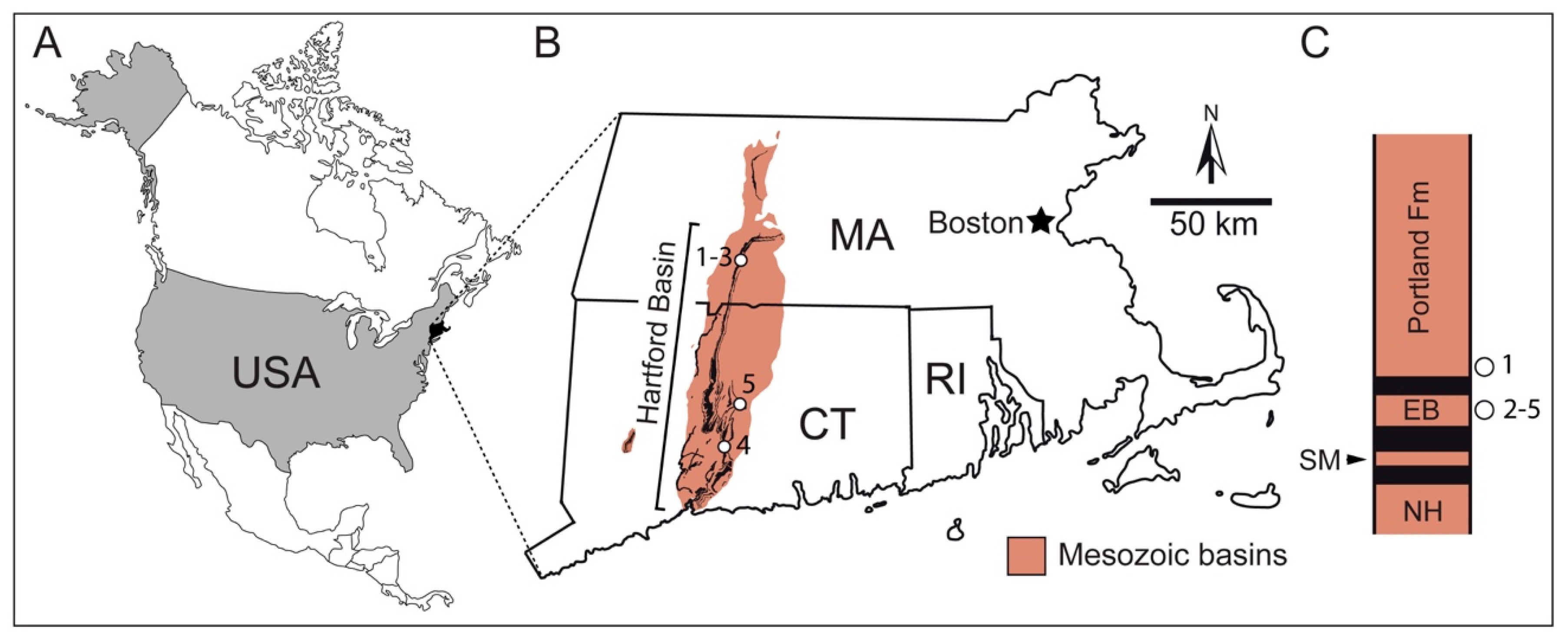
2. Geological Context

The tracksites examined in this study are located within the Hartford Basin, in western Connecticut and Massachusetts, USA (Figure 1). The Hartford Basin is a part of a larger group of rift basins in eastern North America called the Newark Supergroup, which formed in the Late Triassic and Early Jurassic as Pangea broke up and the Atlantic Ocean formed [14,15,16]. Deposition is thought to have spanned from either the Landinian or Carnian stages of the Triassic Period to at least the Sinemurian Stage of the Jurassic Period [17,18]. The sedimentary rocks that filled the basin are primarily of lacustrine, fluvial, and alluvial origin, with minor aeolian deposits, and are interspersed with mafic intrusive and extrusive igneous rocks. Although dinosaur tracks are found in rocks representing nearly all sedimentary environments, they are most abundant in the lacustrine rocks [19]. These lake-derived rocks exhibit cyclical alternations of red shale exhibiting abundant desiccation cracks to gray and black laminated shale lacking evidence of subaerial exposure. Olsen [20] proposed that the cyclically alternating lacustrine beds are indicative of fluctuations in lake level resulting from Milankovich Cycle climate forcing. Red, mud-cracked shales are thought to represent deposition under playa conditions, whereas black shales represent deposition during lake highstands.
The dinosaur tracks examined for this study come from five localities, including Dinosaur Footprint Reservation (DFR), William Murray quarry (WMQ), Gary Gaulin tracksite (GGT), Powder Hill Dinosaur Park (PHDP), and Dinosaur State Park (DSP) (Table 1). The rocks at DFR belong to the Portland Formation, whereas those from the other four localities belong to the East Berlin Formation, which underlies the Portland and is separated from it by Hampden Formation lava flows [12,13,21,22]. The beds at these localities, their sedimentary structures, and their inferred depositional environments will be described in more detail below.

3. Materials and Methods

3.1. Dinosaur Track Identification, Ichnotaxonomic Assignment, and Track Depth

The tracks were identified under low-angle light conditions in the early morning and late afternoon. We recorded dimensions, such as length, width, angle of divarication, and digit III projection ratio for each track, and used these parameters to assign the tracks to ichnotaxa following revised diagnoses for Eubrontes and Eubrontes giganteus provided by Olsen et al. [23]. These workers diagnosed Eubrontes as a track of a bipedal, functionally tridactyl dinosaur that is greater than 25 cm long, has a relatively short third digit and broad pes, and an angle of divarication between 25° and 40°. These authors provided the following defining characteristics for Eubrontes giganteus: the track is greater than 30 cm long, the digit III projection ratio is about 2.2, the length to width ratio is 1.4 to 1.5, digits II and IV project about equally along the axis of digit II, and the divarication is 30° to 40°. Track depth was measured by placing a ruler over the proximal pad of digit III and measured down from the ruler to the bottom of the track. Depth was considered in conjunction with qualitative characteristics of the track, such as the presence or absence of pad and claw details and mud push-ups or collapse structures to determine the timing if the tracks were made in wet or dry sediment.

3.2. Tracksite Mapping

All sites and excavated slabs that we mapped, with the exception of the main (Ostrom) bed at DFR and the Mount Holyoke College slab, were mapped by hand using a 1 m2 chalk grid applied directly on the track surface. Preliminary maps, with a scale of 39.4 to 1, were constructed on graph paper with grid squares measuring 2.54 cm on a side. The maps were later digitized in the lab. The Mount Holyoke College slab is mounted vertically and a map was constructed by tracing the outline of the slab and tracks from photographs.
Due to its large size, the main track bed of the DFR site was mapped using a Leica Flexline TS/02 total station (Leica Geosystems AG, Heerbrugg, Switzerland) with its northing, easting, and elevation setup on three points along the perimeter of the site. The outline of the perimeter was plotted by moving the prism along the edge of the outcrop at irregular intervals every couple of cm. The position of each footprint was characterized by two points: one proximal (usually the metatarsal-phalangeal pad behind digit four) and one distal (usually the tip of digit three). The northing, easting, and elevation data for the tracks and the perimeter were sorted in excel and then uploaded to Autocad software (Autodesk, San Rafael, CA, USA) to produce a preliminary map that showed the data in plan view. Data were then rotated 13° to account for the current dip of the beds. Lastly, the Autocad map was then exported to Adobe Illustrator (Adobe Systems, San Jose, CA, USA) to produce the final map.

3.3. Estimating the Number of Individuals

Although it is possible that a trackmaker crossed the surface more than once, thus leaving more than one trackway, we estimated the maximum number of trackmakers by assuming that a single animal crossed the surface only once, thus leaving only one trackway or isolated track. On Bed 2 at Powder Hill Dinosaur Park, this approach was difficult because the bed is exposed discontinuously throughout the quarry. There, we attempted to link trackway segments based on similarities in size, shape, and orientation.

3.4. Orientation of Sedimentary Structures and Tracks

The orientations of sedimentary structures and tracks were measured using a Brunton compass. The crests of oscillation ripples, which form parallel or oblique to modern shores [24], and the long axes of fossilized wood fragments, which typically orient parallel or perpendicular to currents [25], were recorded to estimate the direction of the paleoshoreline. Most dinosaur trackways were relatively straight and their orientations were measured from the bearing of a string run through their midlines. The direction of movement for dinosaurs that left isolated tracks was estimated from the compass bearing of the track, as measured along the length of digit III.

3.5. Statistical Analysis and Rose Diagram Construction

For each site and bedding plane, we tested the track and trackway orientations for directional preference using the PAST software package, version 3.14 [26]. PAST performs three tests for preferred direction, including Rayleigh’s R, Rao’s U, and chi-squared. Given the apparent bimodality in some data, and the fact that bimodality is to be expected if geographic boundaries controlled direction of travel, we performed the tests on orientations (e.g., treating travel due north and due south as equivalent). For all localities, the three tests gave congruent results (either significant or not significant at the 0.05 level). A significant result indicates that there is a preferred direction to travel; that is, orientations deviate significantly from random. Rose diagrams for sedimentary structures were initially generated in PAST and then exported to Adobe Illustrator for finishing touches; those for trackways were constructed by hand.

4. Site Descriptions and Trackway Orientations

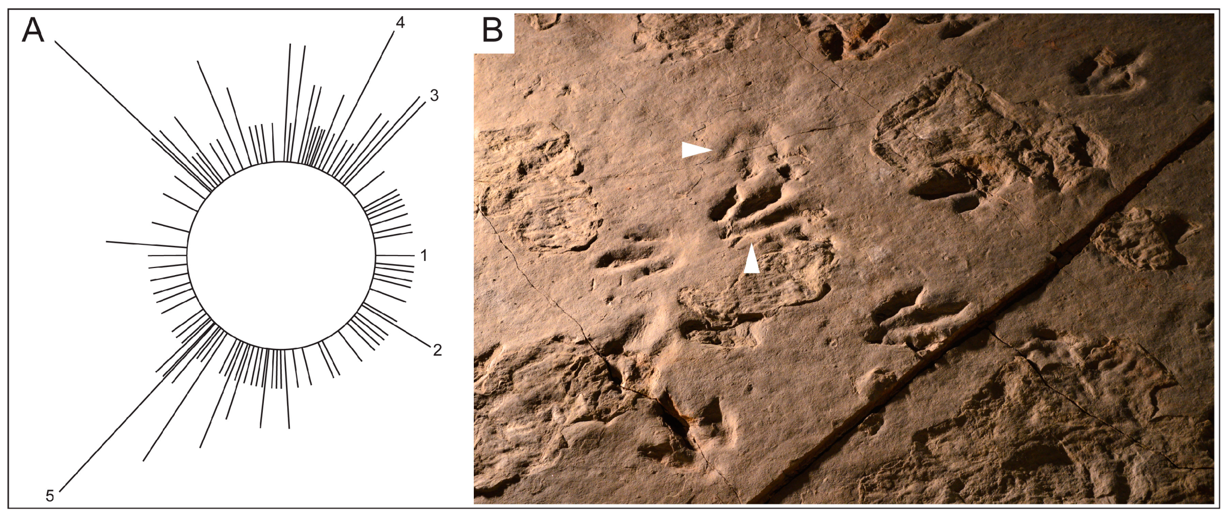
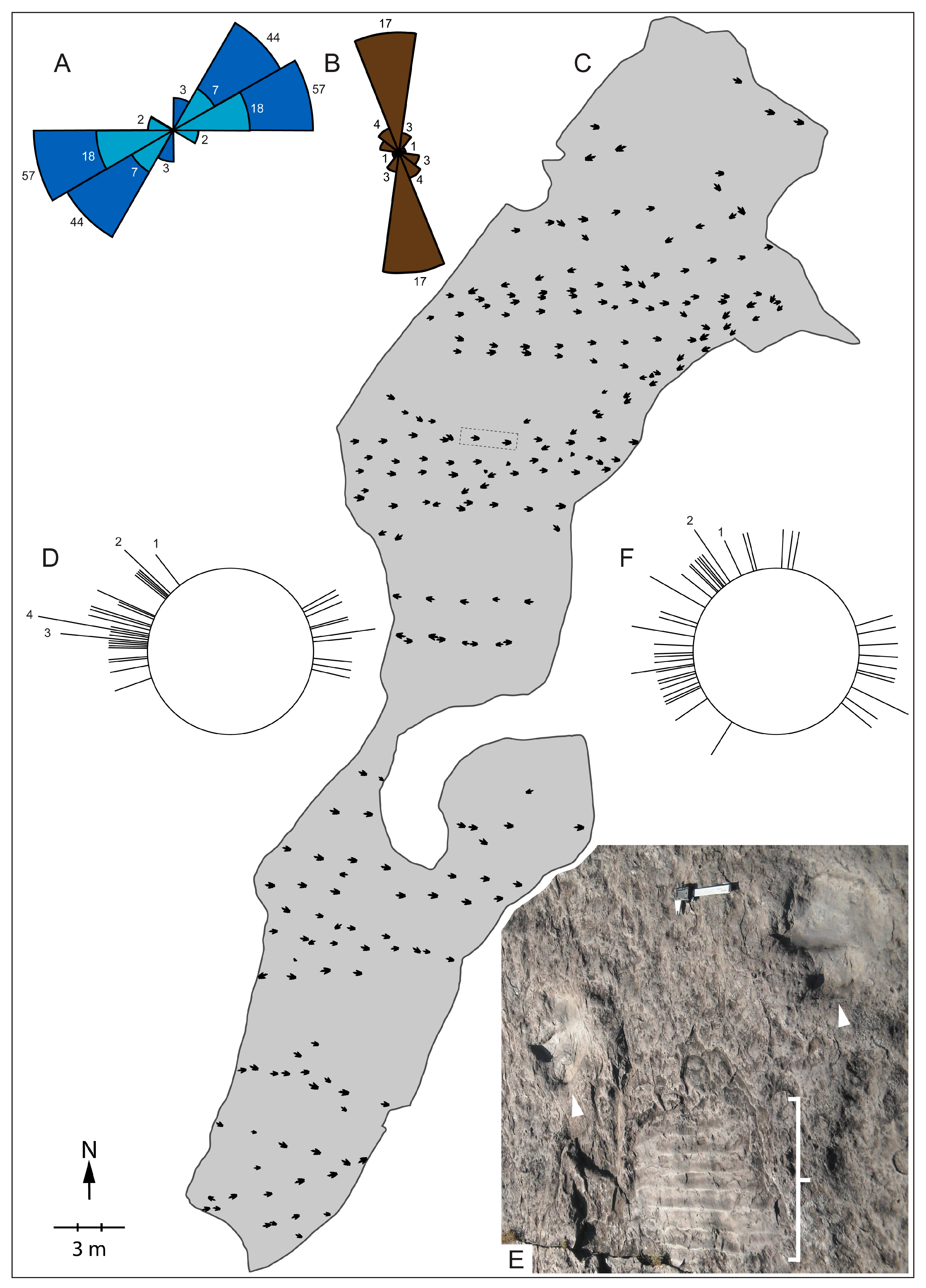
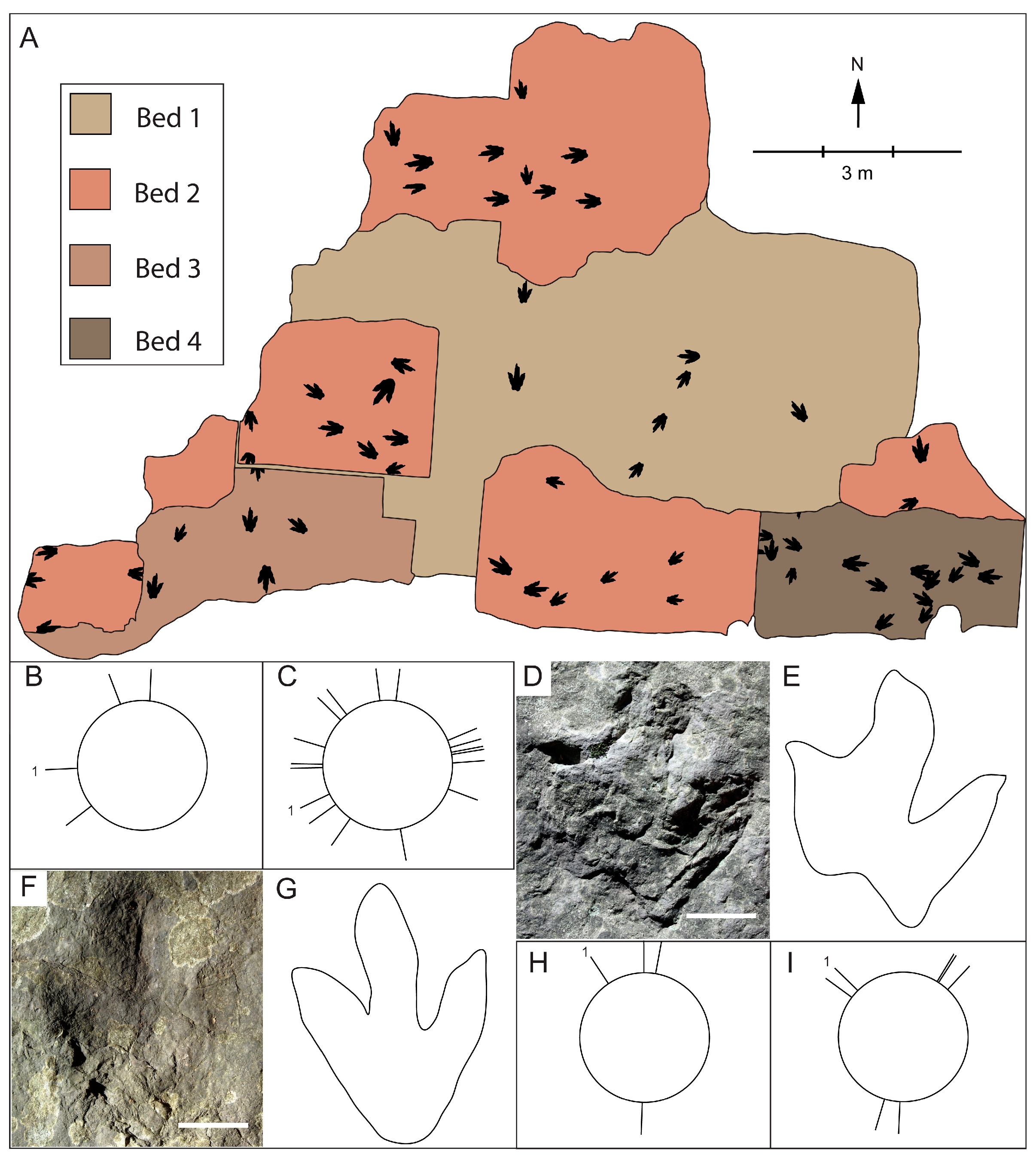
4.1. Dinosaur Footprint Reservation

DFR is located in Holyoke, Massachusetts along US Highway 5 at 42°14′29.99′′ N 72°37′24.83′′ W. Approximately 69 m of lacustrine strata are discontinuously exposed there [22]. The strata belong to the basal portion of the Portland Formation [23], which is the uppermost sedimentary formation within the Hartford Basin. It is an historically and scientifically significant site because it is the first location at which dinosaur gregariousness was inferred [1], and because it is the location from which the type specimen of Eubrontes giganteus was collected [23]. Beds at the base of the section, including the main track bed discussed by Hitchcock [1] and Ostrom [2], are gray and were deposited as sediment in a shallow, yet permanent, lake, as is evidenced by the lack of subaerially produced sedimentary structures, such as raindrop imprints and desiccation cracks [23,27]. By contrast, beds near the top of the section exhibit mud cracks and some are red, suggesting that the depositional regime shifted to a playa lake with at least intermittent drying [23].
Oscillation ripple marks are prominent features of many DFR beds, with the exception of the main track bed mapped by Ostrom [2], although faint ones occur on that bed as well [27]. Two beds, one approximately 1–2 cm below, and the other about 13 cm above the main track bed, exhibit ripple marks with crest orientations of 200°–277° and 220°–279°, respectively, with averages of 252° and 245° (Figure 2A). Similar ripple crest trends, which range from 220° to 280°, are seen in the beds near the top of the section. The orientations of the plant fossils at this site vary based on size (Figure 2B). Small plant fragments with diameters less than 10 cm are oriented between 300° and 340°, or approximately northwest to southeast, and larger fragments with diameters above 10 cm are oriented between 230° and 260°. Thus, the larger woody fragments are nearly parallel to the ripples, whereas the smaller fragments are oriented approximately perpendicular to the ripples. Considering the orientation of the ripple crests, we infer that the paleoshoreline was oriented approximately northeast to southwest, and that the larger woody fragments aligned parallel to the shore. By contrast, it appears that the smaller woody fragments aligned perpendicular to the shore.
Recent remapping of the site has shown that there are 805 tracks impressed on the main track bed [27]. Of the 805 tracks, 236 of them are Eubrontes giganteus (Figure 2C). These tracks are estimated to have been made by 53 different animals. There is a statistically significant bimodal distribution of tracks and trackways on the main track bed (p < 0.01 for all three tests; n = 53), with forty of them, or 75% of the total, trending to the west, and the remainder oriented to the east (Figure 2D). Restricting the tests to trackways (i.e., removing isolated tracks) did not change these results (n = 39). The tracks and trackways are approximately parallel to the ripple crests (Figure 2E). A similar statistically significant, east-to-west bimodal track distribution has been observed on beds near the top of the DFR section (p < 0.05 for all three tests; n = 49) [27,28], although there is more variability in the orientations (Figure 2F).

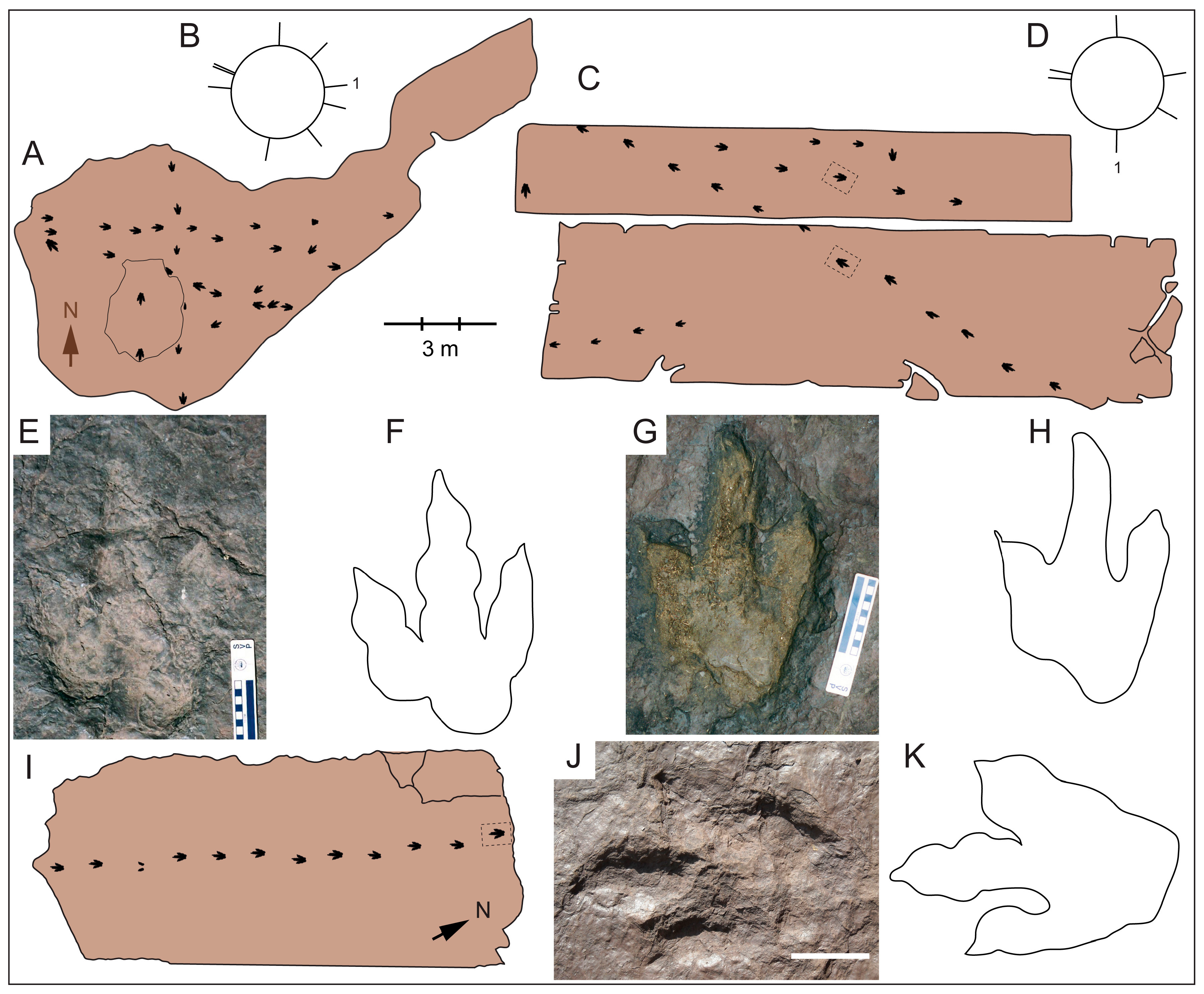
4.2. William Murray Quarry

William Murray operated a small stone quarry in Holyoke, Massachusetts in the 1920s. The rock he excavated is derived from the East Berlin Formation and its red color, along with abundant ripple marks and desiccation cracks, indicate that it was produced in a shallow, ephemeral lake. The rock was primarily used for wall construction, but when Mr. Murray found a bed bearing dinosaur tracks he began selling slabs with the tracks to wealthy locals, such as Ms. Belle Skinner and Mrs. Aaron Bagg, both of Holyoke, Massachusetts. He also sold track-bearing slabs to institutions such as Clark University, in Worcester, Massachusetts; Mount Holyoke College, in South Hadley, Massachusetts, and Forest Park, in Springfield, Massachusetts [12]. Unfortunately, the slabs sold to Mrs. Aaron Bagg and to Clark University have been lost and they are presumed to no longer exist. The other three slabs remain, and are available for study. Belle Skinner’s residence is now the Wistariahurst Museum and the tracks are on display in an old driveway [29].

4.2.1. In Situ Tracks

When Murray ceased quarrying operations in the 1930s, due to lack of demand, a portion of the track-bearing surface remained exposed on the quarry floor (Figure 3A). The track bed was reburied to prevent vandalization, but was subsequently uncovered and the tracks on it were described and evaluated [12]. Twenty-three animals are thought to have made the 65 footprints that were found. Of those, 30 tracks in eight trackways, along with an isolated footprint, are large enough to be considered E. giganteus. Sample size for the in situ tracks (Figure 3A) is small (n = 9), and, visually, there is no clear alignment (Figure 3B). The three statistical tests failed to detect a preferred orientation (p > 0.05). Two of the trackways are oriented to the northwest and are nearly parallel (Figure 3B), but they differ in depth and morphology, suggesting that they were made at different times, as shown by Getty [12]. The shallower trackway consists of five tracks with an average depth of only 6 mm, and each track exhibits claw and toe-pad details. By contrast, the deeper trackway, which consists of six steep-walled footprints with an average depth of 23 mm, shows evidence for mud collapse and mud push-ups, and exhibits only the gross outline of the foot.

4.2.2. Tracks on Excavated Slabs

The slab sold to Mount Holyoke College is the smallest of the three remaining slabs from Murray Quarry, and the footprints on it are relatively faint. Only a single track on this slab is large enough to be considered E. giganteus. The Forest Park and Wistariahurst Museum slabs are much larger and have numerous tracks and trackways on them, including four E. giganteus trackways and two isolated tracks (Figure 3C). These two slabs lay adjacent to each other in the quarry with little or no intervening stone, as is evidenced by three trackways that cross both slabs [12]. The orientation of the slabs when in the quarry is not known, so the orientations of trackways on them cannot be compared with those remaining in situ. They can, however, be compared to each other. Two of the trackways are approximately parallel (Figure 3D), but like the trackways remaining in the quarry, these trackways are of different depths and exhibit morphological variations that suggest that they were made at different times. Figure 3E,F shows a 12-mm deep track, from a five-step trackway with average track depth of 14 mm. This track, along with the others in the trackway, exhibits claw and toe-pad details. By contrast, Figure 3G,H shows a 32-mm deep track that belongs to a 12-step trackway with an average track depth of 22 mm. This track, along with the others in the trackway, shows only the gross outline of the foot along with mud push-ups between the toes and evidence of mud collapse.

4.3. Gary Gaulin Dinosaur Tracksite

Trace fossils at the Gaulin Dinosaur Tracksite in Holyoke, Massachusetts, were initially discovered by property owner Gary Gaulin while constructing a fishpond in March 1996. Since then, continued excavations have exposed approximately 2 m of reddish brown mudstone and fine-grained sandstone of the East Berlin Formation. All of the beds exhibit prominent mud cracks and oscillation ripples indicative of an ephemeral playa-lake environment, and one bed exhibits desiccation cracks that are sinuous in cross section that are indicative of incipient soil formation [30]. Hundreds of small to medium-sized tridactyl vertebrate tracks have been identified, most of which are attributed to the ichnogenera Anomoepus, Anchiauripus, and Grallator [31]. Treptichnus bifurcus and Skolithos are common at the site [32], and the type and only specimen of an arthropod body imprint Cheliceratichnus lockleyi, attributed to a camel-spider-like arthropod, was found there [33].
Most footprints at the Gaulin Site, including the theropod tracks Anchisauripus and ornithischian tracks Anomoepus, belong to relatively small trackmakers. However, two Eubrontes giganteus trackways have been found at the site as well. The first is a trackway composed of 12 tracks that was found on a bed, near the top of the outcrop, which has an exposed surface area of ~63 m2 (Figure 3I–K). This bed is larger than others, such as the Murray Quarry, in the Hartford Basin on which larger numbers of E. giganteus trackways have been found. The second occurrence was found recently on a bed approximately 12 cm below the other E. giganteus trackway. The track is still partly obscured by overlying layers on the edge of a ledge, and too little of the bed is exposed to determine if other trackways are preserved on it. The two E. giganteus trackways were undoubtedly produced at different times, as evidenced by their being on different beds.

4.4. Powder Hill Dinosaur Park

Powder Hill Dinosaur Park, in Middlefield, Connecticut is the site of a small brownstone quarry that was active in 1848–1849 [34]. Due to the presence of dinosaur tracks, the site was donated to Yale University in 1929, and ownership was ultimately transferred to the town of Middlefield in 1976 [13]. Footprints are exposed on four beds (numbered one to four from the quarry bottom to top) of the East Berlin Formation that are composed of muddy, fine-grained sand. Oscillation ripple marks crosscut by desiccation cracks indicate shallow-water deposition followed by drying. Beds of coarse-grained, channeled sands exposed in cross section within the quarry walls indicate a fluvial influence.
Getty et al. [13] identified the tracks and trackways of 71 dinosaurs on the four beds at PHDP, 32 of which were large enough to be considered Eubrontes giganteus (Figure 4A). Bed 1 had four trackways on it, with two trackways diverging in a northerly direction and two diverging in a westerly direction (Figure 4B). Bed 2 had 17 trackways, with a slight clustering of five trackways toward the east (Figure 4C), but statistical analysis of trackway orientations showed this not to be significant (p > 0.05; n = 17). Furthermore, the various tracks are a combination of true tracks and undertracks (Figure 4D–G), indicating that the animals crossed the surface at different times. Bed 3 had four E. giganteus impressed on it, with three trackways diverging to the north (Figure 4H). The seven trackways on Bed 4 are clustered into three groups (Figure 4I), with one group oriented to the northeast, a second group oriented to the south, and a third group oriented to the northwest. Analysis of the trackway orientations on Bed 4 were not statistically significant, however, although sample size was small (p > 0.05; n = 7).

4.5. Dinosaur State Park

The DSP site, which is located in Rocky Hill, Connecticut, was discovered in 1967 during construction of a new state building [30]. The locality is considered to be one of the largest dinosaur tracksites in the world, with an estimated 2000 tracks preserved on two beds [35,36,37,38]. Of those, approximately 600 are on display under a geodesic dome; the remainder were reburied for protection [39]. The majority of the tracks are referred to Eubrontes giganteus, although tracks of smaller theropods, including Anchisauripus and Grallator, and those of protosuchian crocodilians called Batrachopus, have been found [22].
The rock at the site belongs to the East Berlin Formation and is composed of gray arkosic siltstone and mudstone. The presence of raindrop imprints, ripple marks, and desiccation cracks suggests deposition in shallow water followed by subaerial exposure [22]. Unusual tracks consisting primarily of scratch marks have been interpreted as theropod swim tracks [40], which would suggest much deeper water at times, but they also could have been produced by animals walking on firm sediment [37].
Despite the large number of trackways, no preferred orientation has been observed [2,37,38] (Figure 5A). Furthermore, the trackways show variations in morphology, such as depth and sharpness of outline, that suggest that they were made over a period of time during which the sediment dried (Figure 5B). Some of the trackways on the lower bed are known to be undertracks because they occur more distinctly in other areas of the tracksite where the upper bed has not been peeled away.

5. Discussion

5.1. Trackways and Sedimentary Structures at Dinosaur Footprint Reservation

Hitchcock [1] first cited the trackways at DFR as evidence of gregarious behavior in 1836, although he thought that the trackmakers were birds. Over a century later, Ostrom [2] mapped the site and wrote a seminal paper on dinosaur gregariousness in which the evidence from DFR figured prominently. Ostrom argued that, in the absence of evidence for a physical barrier at the site, the large number of trackways was best explained by the animals traveling together as a herd. Since the publication of his paper, the trackways at DFR have been cited by numerous other authors discussing the evidence for dinosaur social behavior [41,42,43]. Not all researchers, however, have been convinced that trackway parallelism at the site indicates gregariousness [22,40,44]. These other authors have pointed to the presence of ripple marks at the site as an indication that the shoreline was nearby and that it might have dictated the animals’ direction of movement. Following up on the work of these other researchers, Getty et al. [27] measured the compass bearing of oscillation ripple marks, which form approximately parallel to the shoreline [24], on beds immediately above and below the main track bed and showed that orientations of the ripple marks and the trackways were strongly coincident. They also reported faint ripple marks with the same general trend on the main bed along with the trackways. These authors also pointed out that the main track bed lacks evidence of subaerial exposure, which means that the lake was stable over a period of time during which more than one individual could have walked alone along the shore, leaving parallel trackways. Thus, these researchers concluded that the animals were following the shoreline. The same trend in trackways and ripples occurs 69 m above the main bed at this site [27,28], indicating that the shoreline dictated the direction of movement for the Eubrontes giganteus trackmaker over a long period of time. Finally, Getty et al. [27] pointed out that beds near the top of the section on which desiccation cracks occur exhibit more divergence in trackway orientations than those on the main bed, which suggests that as the lake dried the animals were free to move in directions that they could not when the lake was full. Overall, the evidence from DFR indicates that the animals followed a shoreline, although it does not falsify the hypothesis that the animals were traveling as a group.

5.2. Trackways and Sedimentary Structures at Other Study Sites

The beds at all of the other sites examined for this study are red in color and exhibit abundant desiccation cracks, indicating that they were deposited in shallow water that later dried up. One locality, the Gary Gaulin Dinosaur Tracksite, exhibits only a single complete E. giganteus trackway on the main bedding plane and thus inferences about gregariousness based on the orientations of multiple trackways cannot be made. Nonetheless, Getty and Fox [21] pointed out that the trackway at the site is at least suggestive of individual, rather than group, behavior because the surface area exposed is as large as that of the Murray Quarry, where multiple trackways have been found. All of the sites other than the Gary Gaulin Dinosaur Tracksite exhibit multiple E. giganteus trackways and therefore gregariousness can be tested for by examining for trackway parallelism. The smaller sites that we examined directly, including the Murray Quarry and Powder Hill Dinosaur Park, exhibit mostly non-parallel suites of trackways. Of those parallel trackways that do occur, those from the Murray Quarry and from Bed 2 at Powder Hill Dinosaur Park were clearly made at different times because they vary in depth and morphology. Furthermore, none of the statistical analyses of trackway orientations suggested non-randomness at the 0.05 level. The evidence at Dinosaur State Park is similar to that from the Murray Quarry and PHDP in that no preferred orientation has been observed, and in that the trackways show signs of having been formed over long periods of time. Thus, the tracksites from the ephemeral lake environments of the East Berlin Formation show no convincing evidence for gregariousness. Considering the stratigraphic difference between the playa lake tracksites and Dinosaur Footprint Reservation, one might be more likely to argue that a non-gregarious trackmaker made the tracks in the underlying East Berlin Formation and a gregarious one made the tracks in the Portland Formation. We deem this hypothesis to be less likely than the one that the Portland Formation perennial lake dictated the direction of movement because the bimodal distribution of trackways in the Portland Formation is not as strong in the uppermost beds at DFR, where desiccation cracks and red mudstones indicate a return to playa lake conditions.

5.3. Eubrontes giganteus Parallelism and the Hypothesis that the Trackmaker Was a Sauropodomorph

Based on comparisons of skeletal material with footprint proportions, most researchers [23,44,45] consider the Eubrontes giganteus trackmaker to have been a theropod. A minority opinion, however, is that the trackmaker was in fact a basal sauropodomorph [46,47,48,49]. Among the evidence that has been presented to support the latter hypothesis is that the parallel trackways at Dinosaur Footprint Reservation indicate that the trackmaker was gregarious. As outlined above, however, DFR is unique in the Hartford Basin in exhibiting numerous parallel trackways, and the parallelism observed there is directly associated with a permanent lacustrine sedimentary facies. The tracksites stratigraphically below DFR in playa lake facies show no statistically significant parallelism, and the beds above the main track bed at DFR show more scattered orientations with the return to playa lake conditions. Based on these facts, we have argued above that the parallelism seen at DFR resulted from the animals’ interaction with the lake rather than from group interaction. Consequently, we argue also that the parallel trackways at DFR should not be presented as evidence in favor of a sauropodomorph trackmaker.

6. Conclusions

In the Hartford Basin of Connecticut and Massachusetts, USA, parallel Eubrontes giganteus trackways are most common in beds at Dinosaur Footprint Reservation that were deposited as sediment in a shallow, yet permanent, lacustrine setting. The rocks upon which the parallel trackways occur are gray in color and lack sedimentary structures, such as mud cracks and raindrop imprints, which indicate subaerial exposure. The orientation of the paleoshoreline at this site was determined using the crests of oscillation ripples and fossilized wood. The ripples and large woody fragments were oriented northeast to southwest, which we hypothesize represents the approximate trend of the shoreline; smaller woody fragments were oriented approximately perpendicular to the inferred shoreline. The parallel trackways at this site exhibit a bimodal distribution that approximates the paleoshoreline. By contrast, trackways in ephemeral lacustrine facies at other sites, which is typified by reddish colored rocks with abundant desiccation cracks, are primarily oriented randomly, even when found in large numbers. The few parallel trackways that do occur in ephemeral lacustrine rocks exhibit morphological variations indicative of changes in sediment saturation, and therefore suggest that the animals crossed the surface at different times. The evidence presented herein suggests that the parallelism seen in Eubrontes giganteus in the Hartford Basin is better explained as a response to a physical barrier (i.e., a large lake) than to gregariousness. Consequently, the parallel trackways from DFR should not be used as evidence to support the hypothesis that the trackmaker was a basal sauropodomorph unless further evidence can substantiate the gregariousness hypothesis.

Acknowledgments

P.R.G. wishes to thank Margery Coombs for initially bringing this topic to his attention. Thanks are due to Carol Constant, Gary Gaulin, Laurie Gaulin, Josh Knox, Mark McMenamin, William Murray, Patrick Sullivan, and the town of Middlefield, Connecticut for granting access to study the dinosaur tracks in their care. We are indebted to Margery Coombs, Walter Coombs, Sebastian Dalman, Eric Dewar, Gary Gaulin, Kevin Getty, Benjamin Hamilton, Taylor Jacobson, Dariusz Mokos, Davien Pares, and Xavier Pares for invaluable field assistance. Portions of P.R.G.’s work were funded by grants from the Commonwealth College (Honors Program) at the University of Massachusetts and from the Center for Environmental Sciences and Engineering at the University of Connecticut.

Author Contributions

P.R.G. and C.A. proposed the mapping projects. All authors participated in mapping and analyzing data from one or more of the dinosaur track sites. P.R.G., C.A., A.J., and A.M.B. wrote the paper.

Conflicts of Interest

The authors declare no conflict of interest. The funding sponsors had no role in the design of the study; in the collection, analyses, or interpretation of data; in the writing of the manuscript, and in the decision to publish the results.

Abbreviations

The following abbreviations are used in this manuscript:
DFRDinosaur Footprint Reservation
DSPDinosaur State Park
WMQWilliam Murray Quarry
GGTGary Gaulin Tracksite
PHDPPowder Hill Dinosaur Park

References

  1. Hitchcock, E. Ornithichnology—Description of the foot marks of birds (Ornithichnites) on New Red Sandstone in Massachusetts. Am. J. Sci. 1836, 29, 308–340. [Google Scholar]
  2. Ostrom, J.H. Were some dinosaurs gregarious? Palaeogeogr. Palaeoclimatol. Palaeoecol. 1972, 11, 287–301. [Google Scholar] [CrossRef]
  3. Razzolini, N.L.; Oms, O.; Castanera, D.; Vila, B.; dos Santos, V.F.; Galobart, À. Ichnological evidence of megalosaurid dinosaurs crossing Middle Jurassic tidal flats. Sci. Rep. 2016, 31494. [Google Scholar] [CrossRef] [PubMed]
  4. Moratalla, J.J.; Hernán, J. Probable palaeogeographic influences of the Lower Cretaceous Iberian rifting phase in the Eastern Cameros Basin (Spain) on dinosaur trackway orientations. Palaeogeogr. Palaeoclimatol. Palaeoecol. 2010, 295, 116–130. [Google Scholar] [CrossRef]
  5. Lockley, M.G.; Houck, K.J.; Prince, N.K. North America’s largest dinosaur trackway site: Implications for Morrison Formation paleoecology. Geol. Soc. Am. Bull. 1986, 97, 1163–1176. [Google Scholar] [CrossRef]
  6. Castanera, D.; Barco, J.L.; Díaz-Martínez, I.; Gascón, J.H.; Pérez-Lorente, F.; Canudo, J.I. New evidence of a herd of titanosauriform sauropods from the lower Berriasian of the Iberian range (Spain). Palaeogeogr. Palaeoclimatol. Palaeoecol. 2011, 310, 227–237. [Google Scholar] [CrossRef]
  7. Currie, P.J. Hadrosaur trackways from the lower Cretaceous of Canada. Acta Palaeontol. Pol. 1983, 28, 63–73. [Google Scholar]
  8. Cotton, W.D.; Cotton, J.E.; Hunt, A.P. Evidence for social behavior in ornithopod dinosaurs from the Dakota Group of northeastern New Mexico, USA. Ichnos 1998, 6, 141–149. [Google Scholar] [CrossRef]
  9. Barco, J.L.; Canudo, J.I.; Ruiz-Omeñaca, J.I. New data on Therangospodus oncalensis from the Berriasian Fuentesalvo tracksite (Villar del Río, Soria, Spain): An example of gregarious behaviour in theropod dinosaurs. Ichnos 2006, 13, 237–248. [Google Scholar] [CrossRef]
  10. Castanera, D.; Pascual, C.; Razzolini, N.L.; Vila, B.; Barco, J.L.; Canudo, J.I. Discriminating between medium-sized tridactyl trackmakers: Tracking ornithopod tracks in the base of the Cretaceous (Berriasian, Spain). PLoS ONE 2013, 8, e81830. [Google Scholar] [CrossRef] [PubMed]
  11. Lockley, M.G. Tracking Dinosaurs: A New Look at an Ancient World; Cambridge University Press: New York, NY, USA, 1991. [Google Scholar]
  12. Getty, P.R. Excavated and in situ dinosaur footprints from the Murray Quarry (Early Jurassic, East Berlin Formation), Holyoke, Massachusetts, USA. Ichnos 2005, 12, 163–178. [Google Scholar] [CrossRef]
  13. Getty, P.R.; Hardy, L.; Bush, A.M. Was the Eubrontes track maker gregarious? Testing the herding hypothesis at Powder Hill Dinosaur Park, Middlefield, Connecticut. Bull. Peabody Mus. Nat. Hist. 2015, 56, 95–106. [Google Scholar] [CrossRef]
  14. Olsen, P.E. On the use of the term Newark for Triassic and Early Jurassic rocks of eastern North America. Newsl. Stratigr. 1978, 7, 90–95. [Google Scholar]
  15. Olsen, P.E.; McDonald, N.G.; Huber, P.; Cornet, B. Stratigraphy and paleoecology of the Deerfield Rift Basin (Triassic–Jurassic, Newark Supergroup), Massachusetts. In Guidebook for Field Trips in the Connecticut Valley Region of Massachusetts and Adjacent States, Volume 2, Proceedings of the New England Intercollegiate Geology Conference, Amherst, MA, USA, 9–11 October 1992; Robinson, P., Brady, J.B., Eds.; University of Massachusetts: Amherst, MA, USA, 1992; pp. 488–535. [Google Scholar]
  16. Withjack, M.O.; Schlische, R.W.; Olsen, P.E. Diachronous rifting, drifting, and inversion on the passive margin of central eastern North America: An analog for other passive margins. Am. Assoc. Pet. Geol. 1998, 82, 817–835. [Google Scholar]
  17. Olsen, P.E.; Kent, D.V. Long-period Milankovitch cycles from the Late Triassic and Early Jurassic of eastern North America and their implications for the calibration of the Early Mesozoic time-scale and the long-term behaviour of the planets. Philos. Trans. R. Soc. Lond. A 1999, 357, 1761–1786. [Google Scholar] [CrossRef]
  18. Olsen, P.E.; Kent, D.V. High-resolution early Mesozoic Pangean climactic transect in lacustrine environments. Zentralbl. Geol. Paläont. A 2000, 1998, 1475–1495. [Google Scholar]
  19. McDonald, N.G. Paleontology of the early Mesozoic (Newark Supergroup) rocks of the Connecticut Valley. Northeast. Geol. 1992, 14, 185–200. [Google Scholar]
  20. Olsen, P.E. A 40-million-year lake record of early Mesozoic orbital climactic forcing. Science 1986, 234, 842–848. [Google Scholar] [CrossRef] [PubMed]
  21. Getty, P.R.; Fox, N. An isolated Eubrontes giganteus trackway from the Gary Gaulin dinosaur track site (Early Jurassic, East Berlin Formation), Holyoke, Massachusetts. Northeast. Geosci. 2015, 33, 16–21. [Google Scholar]
  22. Olsen, P.E. Field Guide for non-marine boundary events in the Newark Basin (New Jersey, Pennsylvania, and Connecticut), eastern United States and their litho-, chrono-, and biostratigraphic context. In Proceedings of the International Geological Correlation Project 458, Orangeburg, NY, USA, 7–12 June 2002; State University of New York: Cortland, NY, USA; Columbia University: New York, NY, USA, 2002; pp. 1–181. [Google Scholar]
  23. Olsen, P.E.; Smith, J.B.; McDonald, N.G. Type material of the type species of the classic theropod footprint genera Eubrontes, Anchisauripus, and Grallator (Early Jurassic, Hartford and Deerfield Basins, Connecticut and Massachusetts, USA). J. Vert. Paleol. 1998, 18, 586–601. [Google Scholar] [CrossRef]
  24. Nichols, G. Sedimentology & Stratigraphy; Blackwell Science: Malden, MA, USA, 1999. [Google Scholar]
  25. MacDonald, D.I.M.; Jefferson, T.H. Orientation studies of waterlogged wood: A paleocurrent indicator? J. Sediment. Petrol. 1985, 55, 235–239. [Google Scholar]
  26. Hammer, Ø.; Harper, D.A.T.; Ryan, P.D. PAST: Paleontological statistics software package for education and data analysis. Palaeontol. Electron. 2001, 4, 9. Available online: http://palaeo-electronica.org/2001_1/past/past.pdf (accessed on 30 January 2017). [Google Scholar]
  27. Getty, P.R.; Judge, A.; Csonka, J.; Bush, A.M. Were Early Jurassic dinosaurs gregarious? Reexamining the evidence from Dinosaur Footprint Reservation in Holyoke, Massachusetts. In Guidebook for Field Trips in Connecticut and Massachusetts, Proceeding of the 47th Annual Meeting of the Northeastern Section of the Geological Society of America, Hartford, CT, USA, 18–20 March 2012; Thomas, M.A., Ed.; State Geological and Natural History Survey of Connecticut: Hartford, CT, USA, 2012; pp. A1–A18. [Google Scholar]
  28. Smith, J.B.; Smith, J.R.; Sweeny, J.P. Mt Tom revisited: A new fossil horizon at Dinosaur Footprint Reservation, Northampton, Massachusetts. J. Vert. Paleol. 1996, 16, 67A. [Google Scholar]
  29. Thibodeau, K.N. Images of America: Holyoke: The Skinner Family and Wistariahurst; Arcadia Publishing: Charleston, SC, USA, 2005. [Google Scholar]
  30. Demicco, R.V.; Gierlowski-Kordesch, E. Facies sequences of a semi-arid closed basin: The Lower Jurassic East Berlin Formation of the Hartford Basin, New England, USA. Sedimentology 1986, 33, 107–118. [Google Scholar] [CrossRef]
  31. Dalman, S.G.; Weems, R.E. A new look at morphological variation in the ichnogenus Anomoepus, with special reference to material from the Lower Jurassic Newark Supergroup: Implications for ichnotaxonomy and ichnodiversity. Bull. Peabody Mus. Nat. Hist. 2015, 54, 67–124. [Google Scholar] [CrossRef]
  32. Getty, P.R.; McCarthy, T.D.; Hsieh, S.; Bush, A.M. A new reconstruction of continental Treptichnus based on exceptionally preserved material from the Jurassic of Massachusetts. J. Paleol. 2016, 90, 269–278. [Google Scholar] [CrossRef]
  33. Dalman, S.; Lucas, S. Lower Jurassic arthropod resting trace from the Hartford Basin of Massachusetts, USA. Ichnos 2015, 22, 177–182. [Google Scholar] [CrossRef]
  34. Atkins, T. History of Middlefield and Longhill; Case, Lockwood, and Brainerd: Hartford, SC, USA, 1883. [Google Scholar]
  35. Ostrom, J.H. Peabody paleontologists assist new dinosaur-track park. Discovery 1967, 2, 21–24. [Google Scholar]
  36. Lockley, M.G.; Gillette, D.D. Dinosaur tracks and traces: An overview. In Dinosaur Tracks and Traces; Gillette, D.D., Lockley, M.G., Eds.; Cambridge University Press: New York, NY, USA, 1989; pp. 3–10. [Google Scholar]
  37. Farlow, J.O.; Galton, P.M. Dinosaur trackways of Dinosaur State Park, Rocky Hill, Connecticut. In The Great Rift Valleys of Pangea in Eastern North America; Letourneau, P.M., Olsen, P.E., Eds.; Columbia University Press: New York, NY, USA, 2003; pp. 248–263. [Google Scholar]
  38. Galton, P.M.; Farlow, J.O. Dinosaur State Park, Connecticut, USA: History, footprints, trackways, exhibits. Zubía 2003, 21, 129–173. [Google Scholar]
  39. McDonald, N.G. Window into the Jurassic World; Friends of Dinosaur State Park and Arboretum: Rocky Hill, VT, USA, 2010. [Google Scholar]
  40. Coombs, W.P. Swimming ability of carnivorous dinosaurs. Science 1980, 207, 1198–1200. [Google Scholar] [CrossRef] [PubMed]
  41. Colbert, E.H. The Triassic dinosaur Coelophysis. Mus. North. Ariz. Bull. 1989, 57, 1–160. [Google Scholar]
  42. Lockley, M.G.; Matsukawa, M. Some observations on trackway evidence for gregarious behavior among small bipedal dinosaurs. Palaeogeogr. Palaeoclimatol. Palaeoecol. 1999, 150, 25–31. [Google Scholar] [CrossRef]
  43. Lingham-Soliar, T.; Broderick, T.; Ahmed, A.A.K. Closely associated theropod trackways from the Jurassic of Zimbabwe. Naturwissenschafen 2003, 90, 572–576. [Google Scholar] [CrossRef] [PubMed]
  44. Smith, J.B.; Farlow, J.O. Osteometric approaches to trackmaker assignment for the Newark Supergroup ichnogenera Grallator, Anchisauripus, and Eubrontes. In The Great Rift Valleys of Pangea in Eastern North America; Letourneau, P.M., Olsen, P.E., Eds.; Columbia University Press: New York, NY, USA, 2003; pp. 273–292. [Google Scholar]
  45. Lucas, S.G.; Klein, H.; Lockley, M.G.; Spielmann, J.A.; Gierlinski, G.D.; Hunt, A.D.; Tanner, L.H. Triassic-Jurassic stratigraphic distribution of the theropod footprint ichnogenus Eubrontes. New Mex. Mus. Nat. Hist. Sci. Bull. 2006, 37, 86–93. [Google Scholar]
  46. Weems, R.E. A Late-Triassic footprint fauna from the Culpeper Basin Northern Virginia (USA). Trans. Am. Philos. Soc. 1987, 77, 1–79. [Google Scholar] [CrossRef]
  47. Weems, R.E. A re-evaluation of the taxonomy of Newark Supergroup saurischians dinosaur tracks, using extensive statistical data from a recently exposed tracksite near Culpeper, Virginia. In Proceedings of the 26th Forum on the Geology of Industrial Minerals, Charlottesville, VA, USA, 15–18 May 1990; Sweet, P.C., Ed.; Division of Mineral Resources Publications: Charlottesville, VA, USA, 1992; 119, pp. 113–126. [Google Scholar]
  48. Weems, R.E. Plateosaurus foot structure suggests a single trackmaker for Eubrontes and Gigandipus footprints. In The Great Rift Valleys of Pangea in Eastern North America; Letourneau, P.M., Olsen, P.E., Eds.; Columbia University Press: New York, NY, USA, 2003; pp. 293–313. [Google Scholar]
  49. Miller, W.E.; Britt, B.B.; Stadtman, K.L. Tridactyl trackways from the Moenave Formation of southwestern Utah. In Dinosaur Tracks and Traces; Gillette, D.D., Lockley, M.G., Eds.; Cambridge University Press: New York, NY, USA, 1989; pp. 209–215. [Google Scholar]
Figure 1. Geographical and geological context of the dinosaur track sites discussed herein. (A) Map of North America showing the United States in gray and southern New England in black; (B) Inset showing the distribution of Mesozoic basins belonging to the Newark Supergroup in southern New England; (C) Simplified stratigraphic column of the Hartford Basin showing the approximate position of the different sites. Numbers for the sites are as follows: 1, Dinosaur Footprint Reservation; 2, William Murray Quarry; 3, Gary Gaulin Tracksite; 4, Powder Hill Dinosaur Park; 5, Dinosaur State Park. Abbreviations in (B,C) are: CT, Connecticut; EB, East Berlin Formation; MA, Massachusetts; NH, New Haven Formation; RI, Rhode Island; SM, Shuttle Meadow Formation.
Geosciences 07 00013 g001
Figure 2. Sedimentary structures, trackways, and orientations from Dinosaur Footprint Reservation, in Holyoke, Massachusetts. (A) Rose diagram of the orientation of oscillation ripples above (light blue) and below (dark blue) the main track bed; (B) Rose diagram of the long axes of fossilized logs on beds ~69 m above the main track bed; (C) Sketch map of the main track bed; (D) Rose diagram of track and trackway orientations on the main track bed; (E) Photograph of Eubrontes giganteus showing the trackway paralleling the ripples (bracketed) underneath the bed. Digital caliper for scale; (F) Rose diagram of trackway orientations on 23 different beds ~69 m above the main track bed.
Geosciences 07 00013 g002
Figure 3. Eubrontes giganteus tracks, trackways, and orientations from the William Murray quarry, in Holyoke, Massachusetts. (A) Sketch map of the in situ surface; (B) Rose diagram of track and trackway orientations on the in situ surface; (C) Sketch map of the Forest Park (bottom) and Wistariahurst Museum (top) slabs; (D) Rose diagram of the orientations of the tracks and trackways on the slabs; (E,F) photograph and line drawing, respectively, of a 12 mm deep track boxed on the map of the Wistariahurst Museum slab; (G,H) photograph and line drawing, respectively, of a 30 mm deep track boxed on the map of the Forest Park slab; (I) Sketch map of a portion of the Gary Gaulin Dinosaur Tracksite showing the isolated trackway on that bed; (J,K) photograph and line drawing, respectively, of the track boxed in (I). Sketch maps are to scale. Scale bars in (E,G) are in cm; that in (J) is 10 cm.
Geosciences 07 00013 g003
Figure 4. Eubrontes giganteus tracks, trackways, and orientations from Powder Hill Dinosaur Park in Middlefield, Connecticut. (A) Sketch map of the quarry floor showing all track-bearing beds; (B) Rose diagram of track and trackway orientations on Bed 1; (C) Rose diagram track and trackway orientations on Bed 2; (D,E) photograph and interpretive drawing of E. giganteus inferred to be a true track; (F,G) photograph and line drawing, respectively, of a E. giganteus undertrack; (H) Rose diagram of track and trackway orientations on Bed 3; (I) Rose diagram of track and trackway orientations on Bed 4. Scale bars in (D,F) are 10 cm.
Geosciences 07 00013 g004
Figure 5. Eubrontes giganteus orientations and trackways from Dinosaur State Park in Rocky Hill, Connecticut. (A) Rose diagram of track and trackway orientations modified from [2] and used with permission of Elsevier; (B) Photograph of part of the in situ track surface showing random orientation and tracks of different depths. The horizontal arrowhead points to a shallow track with a diffuse outline, whereas the vertical arrowhead points to an adjacent deep track with very distinct margins.
Geosciences 07 00013 g005
Table 1. Summary of dinosaur footprint localities examined for this study. DFR: Dinosaur Footprint Reservation; WMQ: William Murray quarry; GGT: Gary Gaulin tracksite; PHDP: Powder Hill Dinosaur Park; DSP: Dinosaur State Park.
SiteCoordinatesFormationNo. of TracksNo. of AnimalsEnvironmentOrientations
DFR42°14′29.99″ N,
72°37′24.83″ W
Portland23653Permanent lakeBimodal
WMQ42°12′02.59″ N,
72°38′51.54″ W
East Berlin309Playa lakeRandom
GGT42°11′51.74″ N,
72°38′41.16″ W
East Berlin121Playa lakeN/A
PHDP41°30′11.48″ N,
72°43′48.73″ W
East Berlin6432Playa lakeRandom
DSP41°39′06.82″ N,
72°39′24.66″ W
East Berlin~2000UnknownPlaya lakeRandom
N/A: Not applicable.

