
Late Holocene Glacier Dynamics in the Miyar Basin, Lahaul Himalaya, India

 , , ,
, , ,
Abstract
:1. Introduction
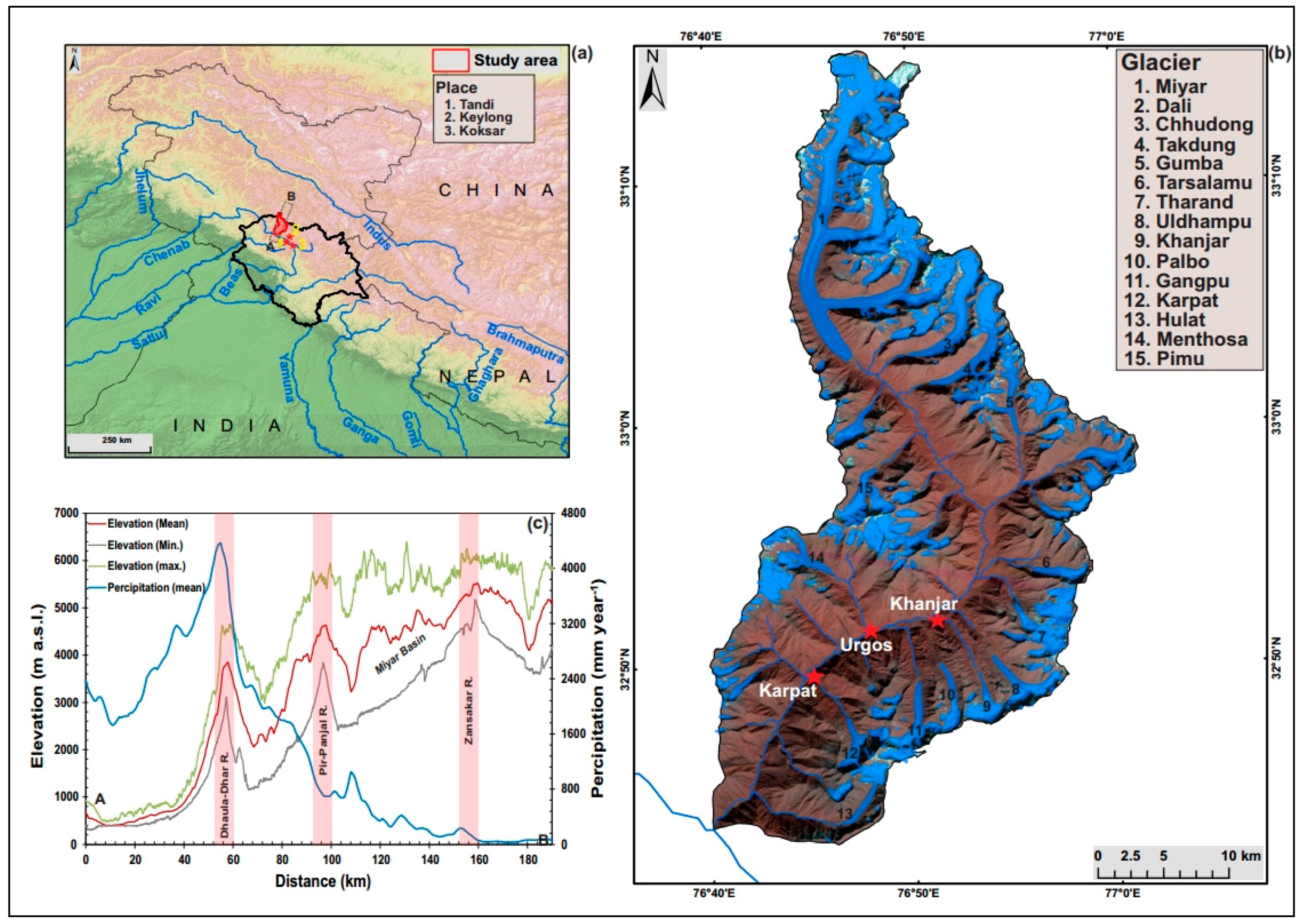
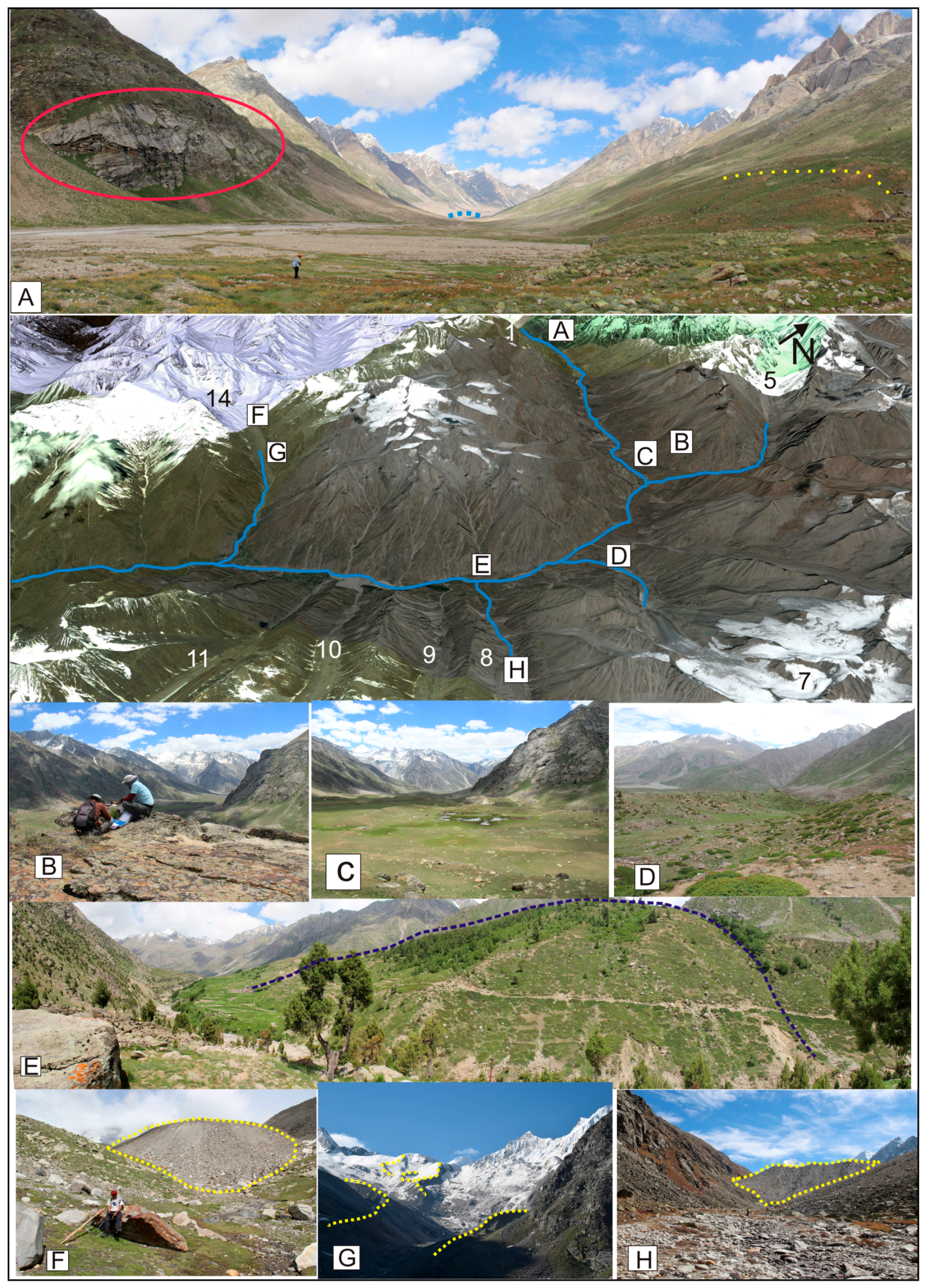
2. Study Area
3. Material and Methods
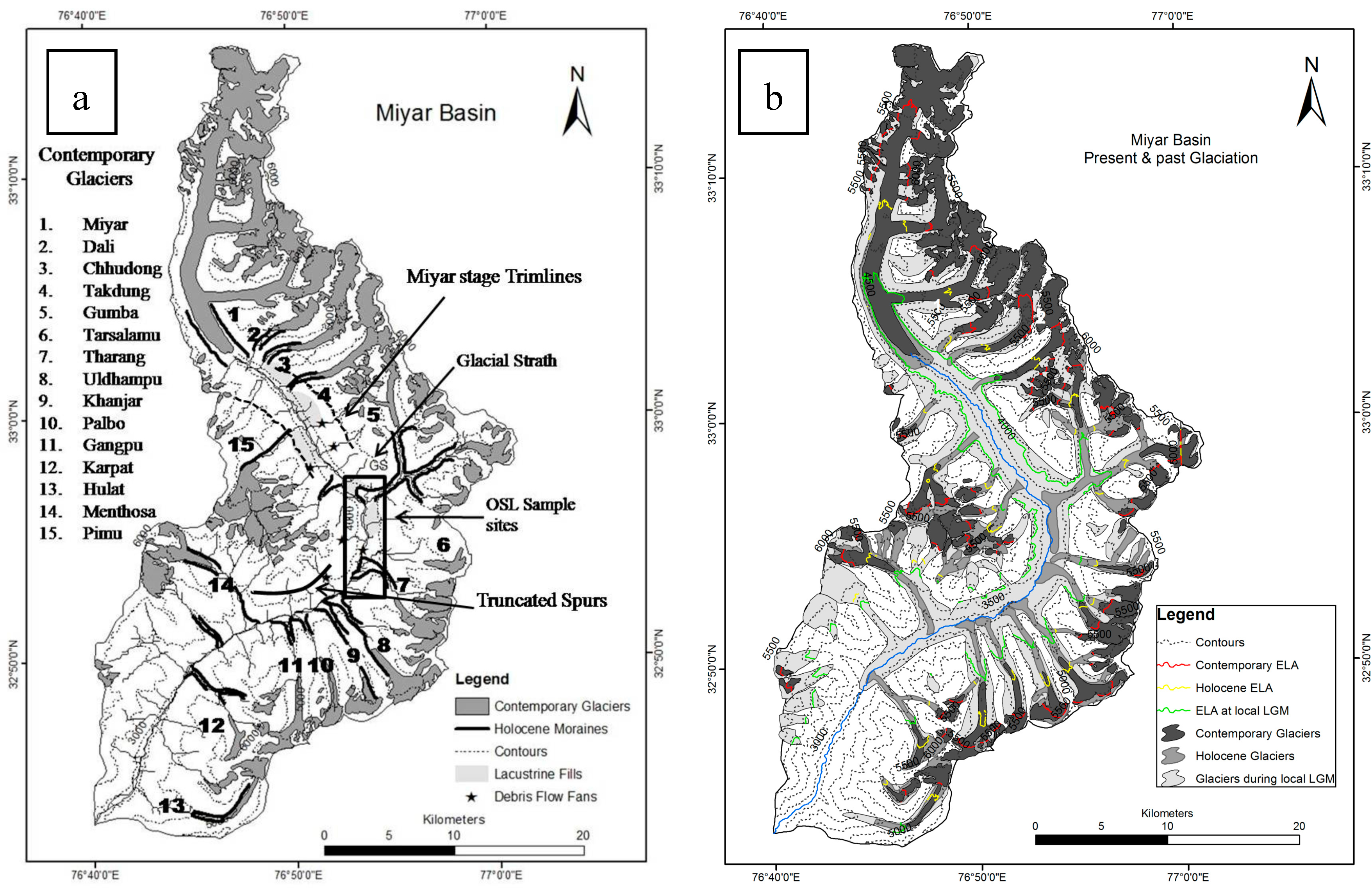
3.1. Geomorphological Mapping
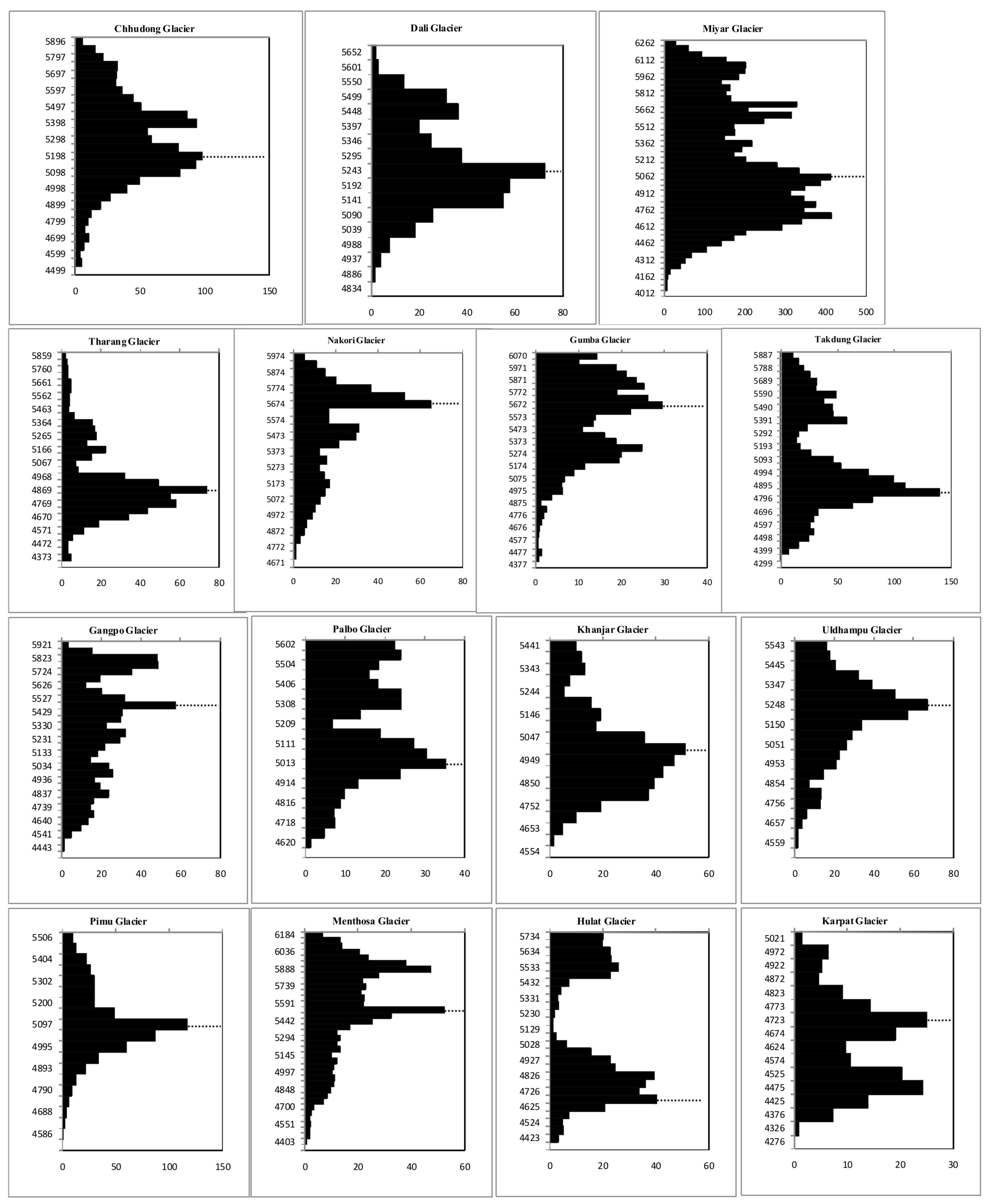
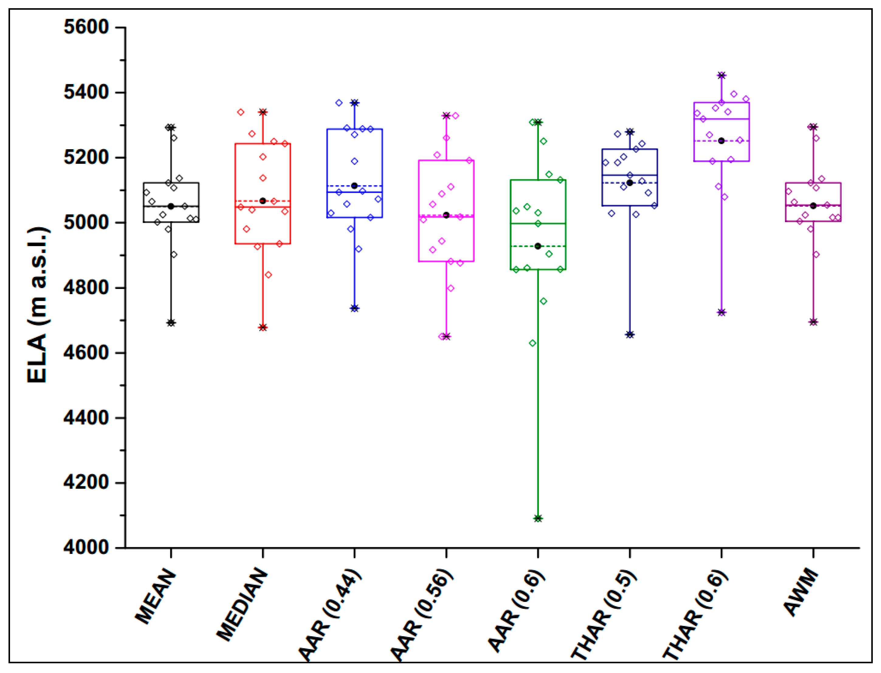
3.2. Equilibrium-Line Altitudes
3.3. Optically Stimulated Luminescence Dating
4. Results
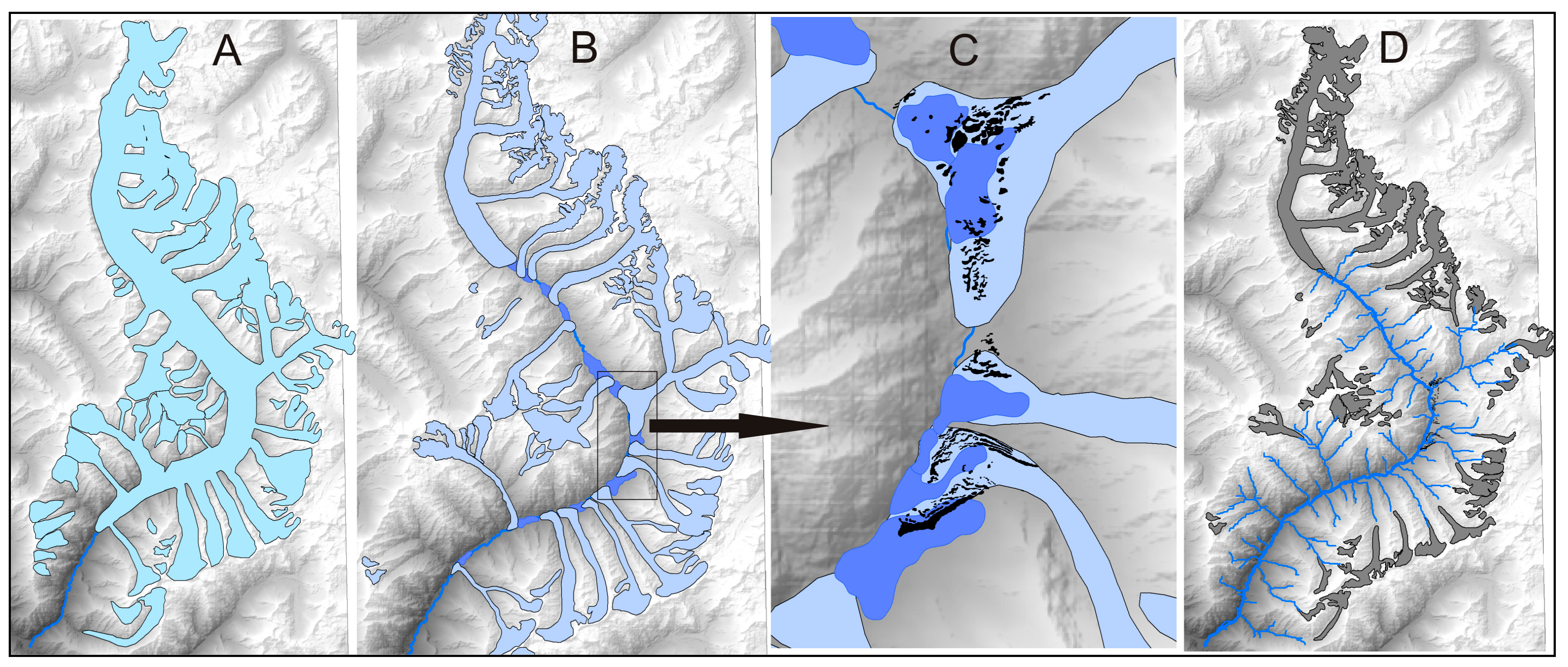
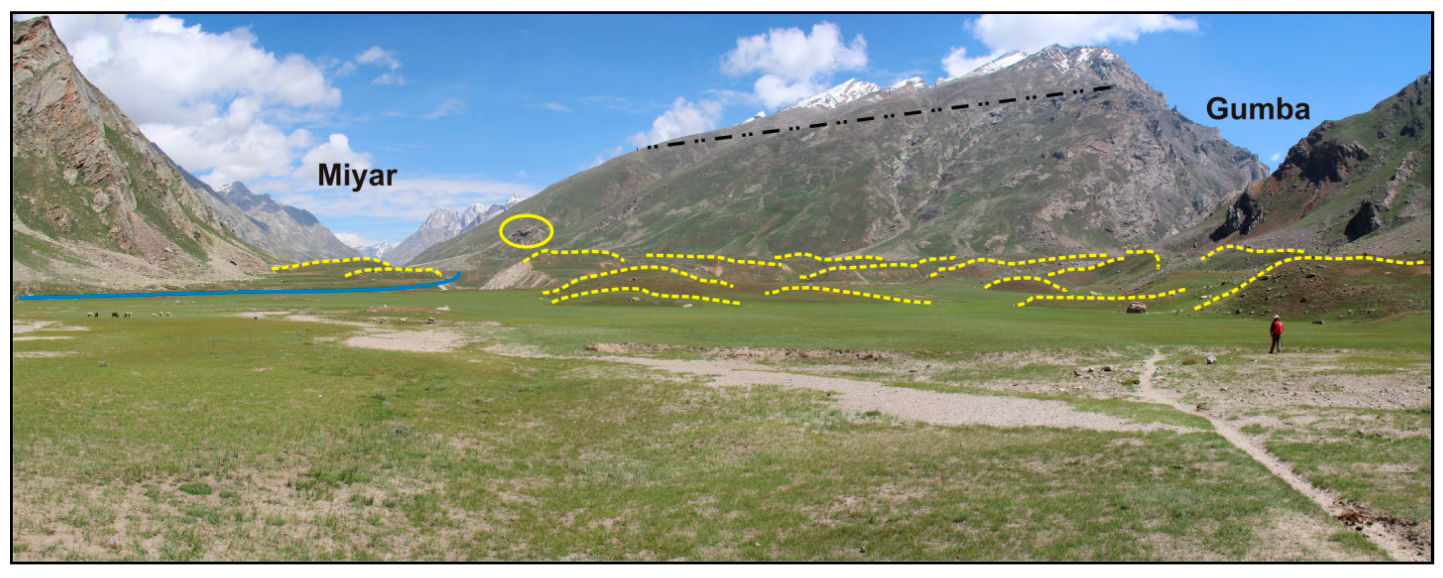
4.1. Miyar Stage (MR-I)
4.2. Khanjar Stage (KH-II)
4.3. Menthosa Advance (M-III)
4.4. Optical Chronology
4.5. Paleotemperature and Ice Volume Estimation
5. Discussion
6. Conclusions
Acknowledgments
Author Contributions
Conflicts of Interest
References
- Molnar, P.; England, P. Late Cenozoic uplift of mountain ranges and global climate change: Chicken or egg? Nature 1990, 346, 29–34. [Google Scholar] [CrossRef]
- Ruddiman, W.F.; Kutzbach, J.E. Plateau uplift and climatic-change. Sci. Am. 1991, 264, 66–75. [Google Scholar] [CrossRef]
- Prell, W.L.; Kutzbach, J.E. Sensitivity of the Indian monsoon to forcing parameters and implications for its evolution. Nature 1992, 360, 647–652. [Google Scholar] [CrossRef]
- Benn, D.I.; Owen, L.A. The role of the Indian summer monsoon and the mid-latitude westerlies in Himalayan glaciation: Review and speculative discussion. J. Geol. Soc. Lond. 1998, 155, 353–363. [Google Scholar] [CrossRef]
- Owen, L.A.; Gualtieri, L.; Finkel, R.C.; Caffee, M.W.; Benn, D.I.; Sharma, M.C. Cosmogenic radionuclide dating of glacial landforms in the Lahul Himalaya, northern India: Defining the timing of Late Quaternary glaciation. J. Quat. Sci. 2002, 17, 279–281. [Google Scholar] [CrossRef]
- Raymo, M.E.; Ruddiman, W.F. Tectonic forcing of late Cenozoic climate. Nature 1992, 359, 117–122. [Google Scholar] [CrossRef]
- Brozovic, N.; Burbank, D.W.; Meigs, A.J. Climatic Limits on Landscape Development in the Northwestern Himalaya. Science 1997, 276, 571–574. [Google Scholar] [CrossRef]
- Zeitler, P.K.; Meltzer, A.S.; Koons, P.O.; Craw, D.; Hallet, B.; Chamberlain, C.P.; Kidd, W.S.F.; Park, S.K.; Seeber, L.; Bishop, M.; et al. Erosion, Himalayan geodynamics, and the geomorphology of metamorphism. GSA Today 2001, 11, 4–9. [Google Scholar] [CrossRef]
- Norton, K.P.; Abbühl, L.M.; Schlunegger, F. Glacial conditioning as an erosional driving force in the Central Alps. Geology 2010, 38, 655–658. [Google Scholar] [CrossRef]
- Willett, S.D. Erosion on a line. Tectonophysics 2010, 484, 168–180. [Google Scholar] [CrossRef]
- Owen, L.A. Latest Pleistocene and Holocene glacier fluctuations in the Himalaya and Tibet. Quat. Sci. Rev. 2009, 28, 2150–2164. [Google Scholar] [CrossRef]
- Scherler, D.; Bookhagen, B.; Strecker, M.R.; von Blanckenburg, F.; Rood, D. Timing and extent of late Quaternary glaciation in the western Himalaya constrained by 10Be moraine dating in Garhwal, India. Quat. Sci. Rev. 2010, 29, 815–831. [Google Scholar] [CrossRef]
- Owen, L.A.; Dortch, J.M. Nature and timing of Quaternary glaciation in the Himalayan–Tibetan orogen. Quat. Sci. Rev. 2014, 88, 14–54. [Google Scholar] [CrossRef]
- Murari, M.K.; Owen, L.A.; Dortch, J.M.; Caffee, M.W.; Dietsch, C.; Fuchs, M.; Haneberg, W.C.; Sharma, M.C.; Townsend-Small, A. Timing and climatic drivers for glaciation across monsoon-influenced regions of the Himalayan–Tibetan orogen. Quat. Sci. Rev. 2014, 88, 159–182. [Google Scholar] [CrossRef]
- Gillespie, A.; Molnar, P. Asynchronous maximum advances of mountain and continental glaciers. Rev. Geophys. 1995, 33, 311. [Google Scholar] [CrossRef]
- Owen, L.A.; Caffee, M.W.; Finkel, R.C.; Seong, Y.B. Quaternary glaciation of the Himalayan—Tibetan orogen. J. Quat. Sci. 2008, 23, 513–531. [Google Scholar] [CrossRef]
- Lehmkuhl, F.; Owen, L.A.; Derbyshire, E. Late Quaternary Glacial History of Northeast Tibet. Quat. Proc. 1998, 6, 121–142. [Google Scholar]
- Lehmkuhl, F.; Owen, L. Late Quaternary glaciation of Tibet and the bordering mountains: A review. Boreas 2005, 34, 87–100. [Google Scholar] [CrossRef]
- Owen, L.A.; Benn, D.I. Equilibrium-line altitudes of the Last Glacial Maximum for the Himalaya and Tibet: an assessment and evaluation of results. Quat. Int. 2005, 138–139, 55–78. [Google Scholar] [CrossRef]
- Böhner, J. General climatic controls and topoclimatic variations in Central and High Asia. Boreas 2006, 35, 279–295. [Google Scholar] [CrossRef]
- Dortch, J.M.; Owen, L.A.; Schoenbohm, L.M.; Caffee, M.W. Asymmetrical erosion and morphological development of the central Ladakh Range, northern India. Geomorphology 2011, 135, 167–180. [Google Scholar] [CrossRef]
- Zech, R.; Zech, M.; Kubik, P.W.; Kharki, K.; Zech, W. Deglaciation and landscape history around Annapurna, Nepal, based on 10Be surface exposure dating. Quat. Sci. Rev. 2009, 28, 1106–1118. [Google Scholar] [CrossRef]
- Rupper, S.; Roe, G.; Gillespie, A. Spatial patterns of Holocene glacier advance and retreat in Central Asia. Quat. Res. 2009, 72, 337–346. [Google Scholar] [CrossRef]
- Owen, L.A.; Bailey, R.M.; Rhodes, E.J.; Holloway, R. Style and timing of glaciation in the Lahul Himalaya, northern India: A framework for reconstructing late Quaternary palaeoclimatic change in the western Himalayas. J. Quat. Sci. 1997, 12, 83–109. [Google Scholar] [CrossRef]
- Owen, L.A.; Gualtieri, L.Y.N.; Finkel, R.C.; Caffee, M.W.; Benn, D.I.; Sharma, M.C. Cosmogenic radionuclide dating of glacial landforms in the Lahul Himalaya, northern India: Defining the timing of Late Quaternary glaciation. J. Quat. Sci. 2001, 16, 555–563. [Google Scholar] [CrossRef]
- Walker, J.D.; Martin, M.W.; Bowring, S.A.; Searle, M.P.; Waters, D.J.; Hodges, K.V. Metamorphism, Melting, and Extension: Age Constraints from the High Himalayan Slab of Southeast Zanskar and Northwest Lahaul. J. Geol. 1999, 107, 473–495. [Google Scholar] [CrossRef]
- Vannay, J.-C.; Steck, A. Tectonic evolution of the High Himalaya in Upper Lahaul (NW Himalaya, India). Tectonics 1995, 14, 253–263. [Google Scholar] [CrossRef]
- Robyr, M.; Vannay, J.-C.; Epard, J.-L.; Steck, A. Thrusting, extension, and doming during the polyphase tectonometamorphic evolution of the High Himalayan Crystalline Zone in NW India. J. Asian Earth Sci. 2002, 21, 221–239. [Google Scholar] [CrossRef]
- Pognante, U.; Castelli, D.; Benna, P.; Genovese, G.; Oberli, F.; Meier, M.; Tonarini, S. The crystalline units of the High Himalayas in the Lahul–Zanskar region (northwest India): Metamorphic–tectonic history and geochronology of the collided and imbricated Indian plate. Geol. Mag. 1990, 127, 101. [Google Scholar] [CrossRef]
- Pognante, U.; Lombardo, B. Metamorphic evolution of the High Himalayan Crystallines in SE Zanskar, India. J. Metamorph. Geol. 1989, 7, 9–17. [Google Scholar] [CrossRef]
- Ali, S.N.; Biswas, R.H.; Shukla, A.D.; Juyal, N. Chronology and climatic implications of Late Quaternary glaciations in the Goriganga valley, central Himalaya, India. Quat. Sci. Rev. 2013, 73, 59–76. [Google Scholar] [CrossRef]
- Fort, M. Geomorphological observations in the Ladakh area (Himalaya): Quaternary evolution and present dynamics. In Stratigraphy and Structure of Kashmir and Ladakh Himalaya; Gupta, V.J., Ed.; Hindustan Publishing: New Delhi, India, 1983; pp. 39–58. [Google Scholar]
- McFadden, E.M.; Howat, I.M.; Joughin, I.; Smith, B.E.; Ahn, Y. Changes in the dynamics of marine terminating outlet glaciers in west Greenland (2000–2009). J. Geophys. Res. 2011, 116, F02022. [Google Scholar] [CrossRef]
- Duncan, C.C.; Klein, A.J.; Masek, J.G.; Isacks, B.L. Comparison of Late Pleistocene and Modern Glacier Extents in Central Nepal Based on Digital Elevation Data and Satellite Imagery. Quat. Res. 1998, 49, 241–254. [Google Scholar] [CrossRef]
- Guo, W.; Liu, S.; Xu, J.; Wu, L.; Shangguan, D.; Yao, X.; Wei, J.; Bao, W.; Yu, P.; Liu, Q.; et al. The second Chinese glacier inventory: Data, methods and results. J. Glaciol. 2015, 61, 357–372. [Google Scholar] [CrossRef]
- Benn, D.I.; Owen, L.A.; Osmaston, H.A.; Seltzer, G.O.; Porter, S.C.; Mark, B. Reconstruction of equilibrium-line altitudes for tropical and sub-tropical glaciers. Quat. Int. 2005, 138–139, 8–21. [Google Scholar] [CrossRef]
- Barr, I.D.; Clark, C.D. Late Quaternary glaciations in Far NE Russia; combining moraines, topography and chronology to assess regional and global glaciation synchrony. Quat. Sci. Rev. 2012, 53, 72–87. [Google Scholar] [CrossRef]
- Meier, M.F.; Post, A.S. Recent variations in mass net budgets of glaciers in western North America. Int. Assoc. Sci. Hydrol. Publ. 1962, 58, 63–77. [Google Scholar]
- Hawkins, F.F. Equilibrium-line altitudes and palaeoenvironments in the Merchants Bay area, Baffin Island, NWT, Canada. J. Glaciol. 1985, 31, 205–221. [Google Scholar] [CrossRef]
- Porter, S.C. Equilibrium-line altitudes of late Quaternary glaciers in the Southern Alps, New Zealand. Quat. Res. 1975, 5, 27–47. [Google Scholar] [CrossRef]
- Azam, M.F.; Ramanathan, A.; Wagnon, P.; Vincent, C.; Linda, A.; Berthier, E.; Sharma, P.; Mandal, A.; Angchuk, T.; Singh, V.B.; et al. Meteorological conditions, seasonal and annual mass balances of Chhota Shigri Glacier, western Himalaya, India. Ann. Glaciol. 2016. [Google Scholar] [CrossRef]
- Dobhal, D.P.; Gergan, J.T.; Thayyen, R.J. Mass balance studies of the Dokriani glacier from 1992 to 2000, Garhwal Himalaya, India. Bull. Glaciol. Res. 2008, 25, 9–17. [Google Scholar]
- Kulkarni, A.V. Mass balance of Himalayan glaciers using AAR and ELA methods. J. Glaciol. 1992, 38, 101–104. [Google Scholar] [CrossRef]
- Mehta, M.; Majeed, Z.; Dobhal, D.P.; Srivastava, P. Geomorphological evidences of post-LGM glacial advancements in the Himalaya: A study from Chorabari Glacier, Garhwal Himalaya, India. J. Earth Syst. Sci. 2012, 121, 149–163. [Google Scholar] [CrossRef]
- Meierding, T.C. Late Pleistocene glacial equilibrium-line altitudes in the Colorado Front Range: A comparison of methods. Quat. Res. 1982, 18, 289–310. [Google Scholar] [CrossRef]
- Burbank, D.W.; Fort, M. Bedrock control on glacial limits: Examples from the Ladakh and Zanskar ranges, north-western Himalaya, India. J. Glaciol. 1985, 31, 143–149. [Google Scholar] [CrossRef]
- Clark, D.H.; Clark, M.M.; Gillespie, A.R. Debris-Covered Glaciers in the Sierra-Nevada, California, and Their Implications for Snowline Reconstructions. Quat. Res. 1994, 41, 139–153. [Google Scholar] [CrossRef]
- Sissons, J.B. A Late-Glacial Ice Cap in the Central Grampians, Scotland. Trans. Inst. Br. Geogr. 1974, 95. [Google Scholar] [CrossRef]
- Bashir, F.; Rasul, G. Estimation of Average Snow Cover over Northern Pakistan. Pak. J. Meteorol. 2010, 7, 63–69. [Google Scholar]
- Siddiqui, M.A.; Maruthi, K.V. Detailed glaciological studies on Hamtah Glacier, Lahaul and Spiti District, H.P. Geol. Surv. India 2007, 140, 92–93. [Google Scholar]
- Thayyen, R.J.; Gergan, J.T.; Dobhal, D.P. Lapse rate of slope air temperature in a Himalayan catchment—A study from Din Gad (Dokriani Glacier) basin, Garhwal Himalaya, India. Bull. Glaciol. Res. 2005, 22, 19–25. [Google Scholar]
- Pratap, B.; Dobhal, D.P.; Bhambri, R.; Mehta, M. Near-surface temperature lapse rate in Dokriani Glacier catchment, Garhwal Himalaya, India. Himal. Geol. 2013, 34, 183–186. [Google Scholar]
- Sati, S.P.; Ali, S.N.; Rana, N.; Bhattacharya, F.; Bhushan, R.; Shukla, A.D.; Sundriyal, Y.; Juyal, N. Timing and extent of Holocene glaciations in the monsoon dominated Dunagiri valley (Bangni glacier), Central Himalaya, India. J. Asian Earth Sci. 2014, 91, 125–136. [Google Scholar] [CrossRef]
- Frey, H.; Machguth, H.; Huss, M.; Huggel, C.; Bajracharya, S.; Bolch, T.; Kulkarni, A.; Linsbauer, A.; Salzmann, N.; Stoffel, M. Estimating the volume of glaciers in the Himalayan–Karakoram region using different methods. Cryosphere 2014, 8, 2313–2333. [Google Scholar] [CrossRef]
- Haeberli, W.; Hoelzle, M. Application of inventory data for estimating characteristics of and regional climate-change effects on mountain glaciers: A pilot study with the European Alps. Ann. Glaciol. 1995, 21, 206–212. [Google Scholar] [CrossRef]
- Richards, B.W.M. Luminescence dating of Quaternary sediments in the Himalaya and High Asia: A practical guide to its use and limitations for constraining the timing of glaciation. Quat. Int. 2000, 66, 49–61. [Google Scholar] [CrossRef]
- Rhodes, E.J. Methodological considerations in the optical dating of quartz. Quat. Sci. Rev. 1988, 7, 395–400. [Google Scholar] [CrossRef]
- Rhodes, E.J.; Pownall, L. Zeroing of the OSL signal in quartz from young glaciofluvial sediments. Radiat. Meas. 1994, 23, 581–585. [Google Scholar] [CrossRef]
- Porat, N.; Botha, G. The luminescence chronology of dune development on the Maputaland coastal plain, southeast Africa. Quat. Sci. Rev. 2008, 27, 1024–1046. [Google Scholar] [CrossRef]
- Bøtter-Jensen, L.; Thomsen, K.J.; Jain, M. Review of optically stimulated luminescence (OSL) instrumental developments for retrospective dosimetry. Radiat. Meas. 2010, 45, 253–257. [Google Scholar] [CrossRef]
- Duller, G.A.T. Assessing the error on equivalent dose estimates derived from single aliquot regenerative dose measurements. Anc. TL 2007, 25, 15–24. [Google Scholar]
- Prescott, J.R.; Hutton, J.T. Cosmic ray contributions to dose rates for luminescence and ESR dating: Large depths and long-term time variations. Radiat. Meas. 1994, 23, 497–500. [Google Scholar] [CrossRef]
- Murray, A.S.; Wintle, A.G. Luminescence dating of quartz using an improved single-aliquot regenerative-dose protocol. Radiat. Meas. 2000, 32, 57–73. [Google Scholar] [CrossRef]
- Jacobs, Z.; Duller, G.A.T.; Wintle, A.G.; Henshilwood, C.S. Extending the chronology of deposits at Blombos Cave, South Africa, back to 140 ka using optical dating of single and multiple grains of quartz. J. Hum. Evol. 2006, 51, 255–273. [Google Scholar] [CrossRef] [PubMed]
- Jacobs, Z.; Wintle, A.G.; Duller, G.A.T.; Roberts, R.G.; Wadley, L. New ages for the post-Howiesons Poort, late and final Middle Stone Age at Sibudu, South Africa. J. Archaeol. Sci. 2008, 35, 1790–1807. [Google Scholar] [CrossRef]
- Galbraith, R.F.; Roberts, R.G.; Laslett, G.M.; Yoshida, H.; Ollley, J.M. Optical dating of single and multiple grains of quartz from Jinmium rock shelter, northern Australia: Part I, experimental design and statistical models. Archaeometry 1999, 41, 339–364. [Google Scholar] [CrossRef]
- Arnold, L.J.; Roberts, R.G. Stochastic modelling of multi-grain equivalent dose (De) distributions: Implications for OSL dating of sediment mixtures. Quat. Geochronol. 2009, 4, 204–230. [Google Scholar] [CrossRef]
- Sharma, M.; Owen, L.A. Quaternary glacial history of NW Garhwal, Central Himalayas. Quat. Sci. Rev. 1996, 15, 335–365. [Google Scholar] [CrossRef]
- Saini, R.; Sharma, M.C.; Deswal, S.; Barr, I.D.; Kumar, P. Glacio-archaeological evidence of warmer climate during the Little Ice Age in the Miyar basin, Lahul Himalaya, India. Clim. Past 2016. [Google Scholar] [CrossRef]
- Owen, L.A.; Derbyshire, E.; Richardson, S.; Benn, D.I.; Evans, D.J.A.; Mitchell, W.A. The quaternary glacial history of the Lahul Himalaya, northern India. J. Quat. Sci. 1996, 11, 25–42. [Google Scholar] [CrossRef]
- Thompson, L.G.; Yao, T.; Mosley-Thompson, E.; Davis, M.E.; Henderson, K.A.; Lin, P.-N.; Clemens, S.; Prell, W.; Muray, D.; Shimmield, G.; et al. A high-resolution millennial record of the south Asian monsoon from Himalayan ice cores. Science 2000, 289, 1916–1920. [Google Scholar] [CrossRef] [PubMed]
- Porter, S.C. Snowline depression in the tropics during the last glaciation. Quat. Sci. Rev. 2001, 20, 1067–1091. [Google Scholar] [CrossRef]
- Barnard, P.L.; Owen, L.A.; Sharma, M.C.; Finkel, R.C. Late Quaternary (Holocene) landscape evolution of a monsoon-influenced high Himalayan valley, Gori Ganga, Nanda Devi, NE Garhwal. Geomorphology 2004, 61, 91–110. [Google Scholar] [CrossRef]
- Dortch, J.M.; Owen, L.A.; Caffee, M.W. Timing and climatic drivers for glaciation across semi-arid western Himalayan–Tibetan orogen. Quat. Sci. Rev. 2013, 78, 188–208. [Google Scholar] [CrossRef]
- Owen, L.A.; Finkel, R.C.; Barnard, P.L.; Haizhou, M.; Asahi, K.; Caffee, M.W.; Derbyshire, E. Climatic and topographic controls on the style and timing of Late Quaternary glaciation throughout Tibet and the Himalaya defined by Be cosmogenic radionuclide surface exposure dating. Quat. Sci. Rev. 2005, 24, 1391–1411. [Google Scholar] [CrossRef]
- Sharma, S.; Chand, P.; Bisht, P.; Shukla, A.D.; Bartarya, S.K.; Sundriyal, Y.P.; Juyal, N. Factors responsible for driving the glaciation in the Sarchu Plain, eastern Zanskar Himalaya, during the late Quaternary. J. Quat. Sci. 2016, 31, 495–511. [Google Scholar] [CrossRef]
- Finkel, R.C.; Mass, A.; Livermore, L.; Owen, L.A.; Barnard, P.L.; Caffee, M.W. Beryllium-10 dating of Mount Everest moraines indicates a strong monsoon influence and glacial synchroneity throughout the Himalaya. Geology 2003, 6, 561–564. [Google Scholar] [CrossRef]
- Bush, A. A comparison of simulated monsoon circulations and snow accumulation in Asia during the mid-Holocene and at the Last Glacial Maximum. Glob. Planet. Chang. 2002, 32, 331–347. [Google Scholar] [CrossRef]
- Rawat, S.; Gupta, A.K.; Srivastava, P.; Sangode, S.J.; Nainwal, H.C. A 13,000year record of environmental magnetic variations in the lake and peat deposits from the Chandra valley, Lahaul: Implications to Holocene monsoonal variability in the NW Himalaya. Palaeogeogr. Palaeoclimatol. Palaeoecol. 2015, 440, 116–127. [Google Scholar] [CrossRef]
- Gupta, A.K.; Das, M.; Anderson, D.M. Solar influence on the Indian summer monsoon during the Holocene. Geophys. Res. Lett. 2005, 32. [Google Scholar] [CrossRef]
- Yadav, R.R.; Braeuning, A.; Singh, J. Tree ring inferred summer temperature variations over the last millennium in western Himalaya, India. Clim. Dyn. 2011, 36, 1545–1554. [Google Scholar] [CrossRef]
- Sinha, A.; Berkelhammer, M.; Stott, L.; Mudelsee, M.; Cheng, H.; Biswas, J. The leading mode of Indian Summer Monsoon precipitation variability during the last millennium. Geophys. Res. Lett. 2011, 38. [Google Scholar] [CrossRef]
- Liang, F.; Brook, G.A.; Kotlia, B.S.; Railsback, L.B.; Hardt, B.; Cheng, H.; Edwards, R.L.; Kandasamy, S. Panigarh cave stalagmite evidence of climate change in the Indian Central Himalaya since AD 1256: Monsoon breaks and winter southern jet depressions. Quat. Sci. Rev. 2015, 124, 145–161. [Google Scholar] [CrossRef]
- Richards, B.W.; Owen, L.A.; Rhodes, E.J. Timing of Late Quaternary glaciations in the Himalayas of northern Pakistan. J. Quat. Sci. 2000, 15, 283–297. [Google Scholar] [CrossRef]
- Owen, L.A.; Finkel, R.C.; Caffee, M.W. A note on the extent of glaciation throughout the Himalaya during the global Last Glacial Maximum. Quat. Sci. Rev. 2002, 21, 147–157. [Google Scholar] [CrossRef]
- Gayer, E.; Lavé, J.; Pik, R.; France-Lanord, C. Monsoonal forcing of Holocene glacier fluctuations in Ganesh Himal (Central Nepal) constrained by cosmogenic 3He exposure ages of garnets. Earth Planet. Sci. Lett. 2006, 252, 275–288. [Google Scholar] [CrossRef]
- Smith, J.A. Early Local Last Glacial Maximum in the Tropical Andes. Science 2005, 308, 678–681. [Google Scholar] [CrossRef] [PubMed]
- Thompson, L.G.; Mosley-Thompson, E.; Davis, M.E.; Mashiotta, T.A.; Henderson, K.A.; Lin, P.-N.; Tandong, Y. Ice core evidence for asynchronous glaciation on the Tibetan Plateau. Quat. Int. 2006, 154–155, 3–10. [Google Scholar] [CrossRef]
- Bisht, P.; Ali, S.N.; Shukla, A.D.; Negi, S.; Sundriyal, Y.P.; Yadava, M.G.; Juyal, N. Chronology of late Quaternary glaciation and landform evolution in the upper Dhauliganga valley, (Trans Himalaya), Uttarakhand, India. Quat. Sci. Rev. 2015, 129, 147–162. [Google Scholar] [CrossRef]
- Eugster, P.; Scherler, D.; Thiede, R.C.; Codilean, A.T.; Strecker, M.R. Rapid Last Glacial Maximum deglaciation in the Indian Himalaya coeval with midlatitude glaciers: New insights from 10 Be-dating of ice-polished bedrock surfaces in the Chandra Valley, NW Himalaya. Geophys. Res. Lett. 2016, 43, 1589–1597. [Google Scholar] [CrossRef]
- Owen, L.A.; Caffee, M.W.; Bovard, K.R.; Finkel, R.C.; Sharma, M.C. Terrestrial cosmogenic nuclide surface exposure dating of the oldest glacial successions in the Himalayan orogen: Ladakh Range, northern India. Geol. Soc. Am. Bull. 2006, 118, 383–392. [Google Scholar] [CrossRef]
- Bhattacharya, A. Vegetation and climate during the last 30,000 years in Ladakh. Palaeogeogr. Palaeoclimatol. Palaeoecol. 1989, 73, 25–38. [Google Scholar] [CrossRef]


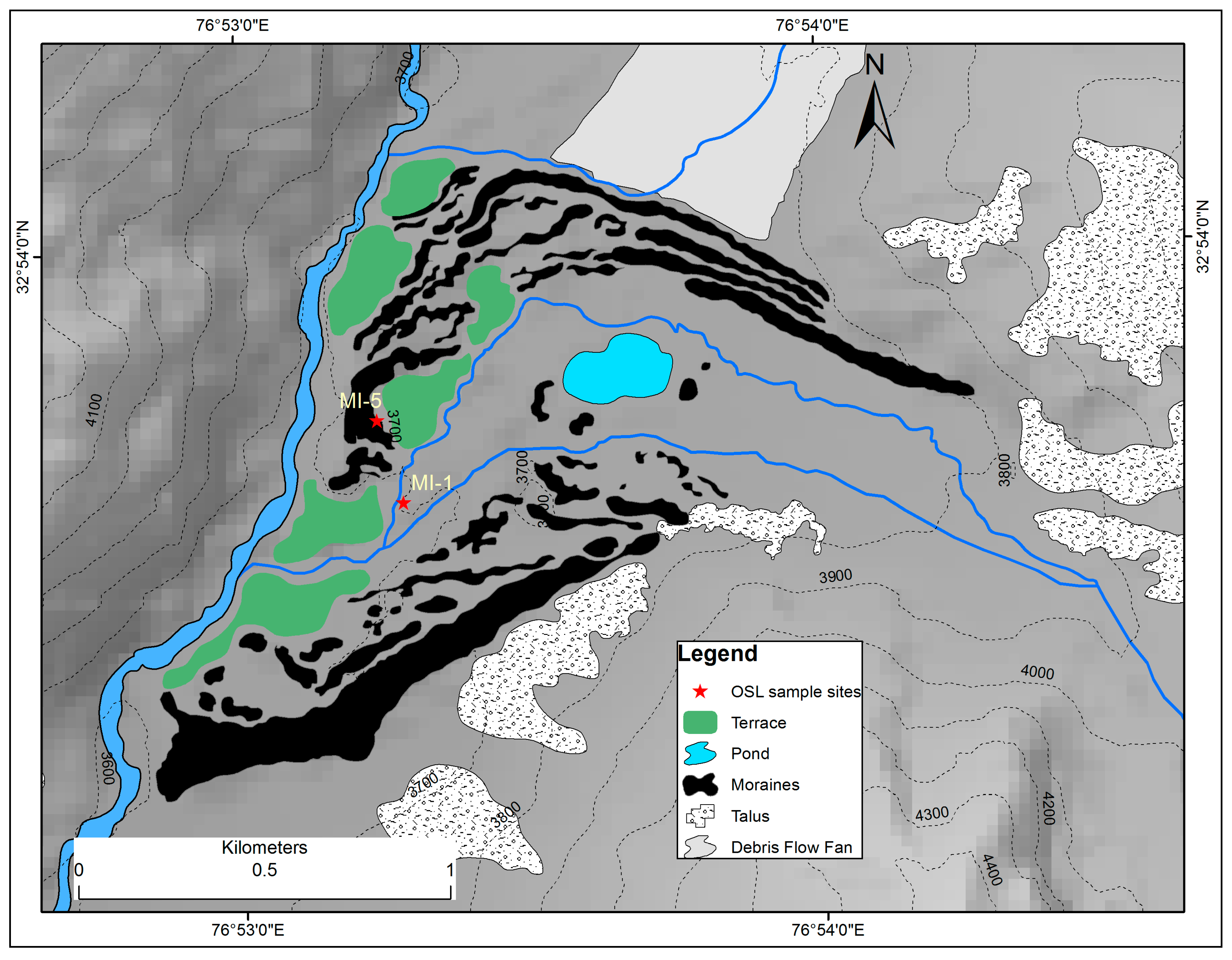
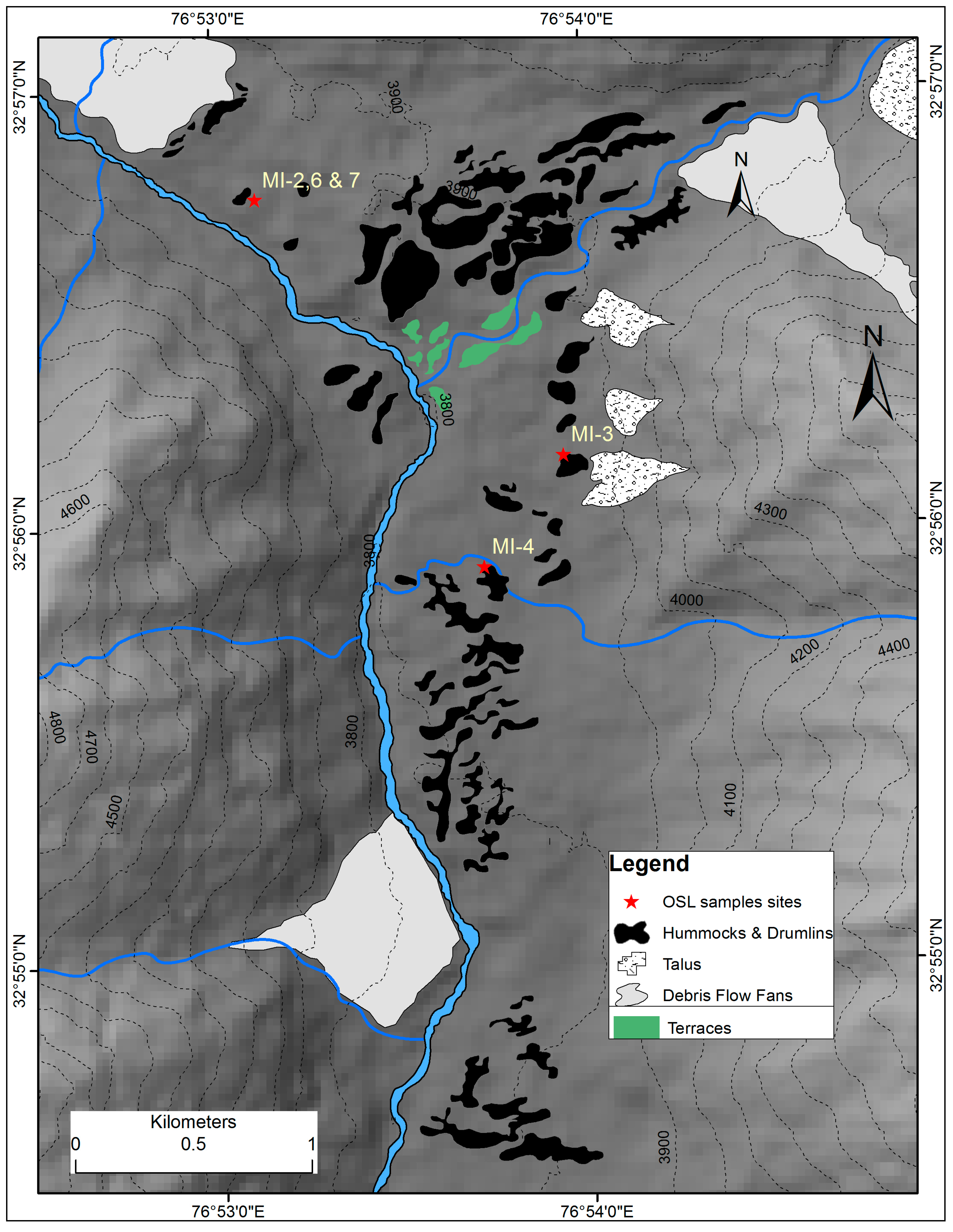
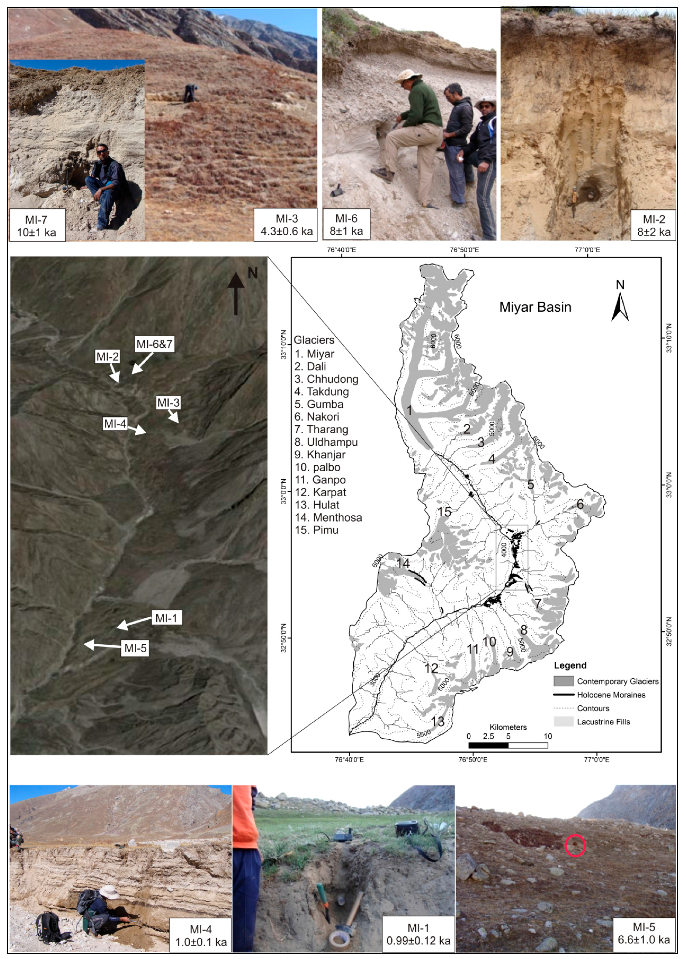
| Sample ID | Location | Site Description |
|---|---|---|
| MI-1 | 32°53′38.40″ N 76°53′09.60″ E | Lacustrine sediment at Tharang, 2 feet from the top. |
| MI-2 | 32°56′45.60″ N 76°53′06.50″ E | Lacustrine sediment at Gumba, 6.5 feet from the top. |
| MI-3 | 32°56′09.77″ N 76°53′56.33″ E | Section of a Drumlin at Thampatan, 5 feet from the top. |
| MI-4 | 32°55′47.34″ N 76°53′48.68″ E | Lacustrine sediments at Thampatan, 5 feet from the top. |
| MI-5 | 32°53′45.24″ N 76°53′13.82″ E | Exposed section of terminal moraine at Tharang, 11 feet from the top. |
| MI-6 | 32°56′47.40″ N 76°53′11.70″ E | Lacustrine sediment at Gumba, 6 feet from the top. |
| MI-7 | 32°56′47.40″ N 76°53′11.70″ E | Lacustrine sediment at Gumba, 8 feet from the top. |
| Sample ID | U (ppm) | Th (ppm) | K (%) | Dose Rate gy/ka | Age (ka) |
|---|---|---|---|---|---|
| MI-1 | 5.9 | 21.6 | 2.9 | 5.0 ± 0.5 | 0.99 ± 0.12 |
| MI-2 | 4.7 | 38.8 | 2.8 | 5.7 ± 0.5 | 8 ± 2 |
| MI-3 | 6.73 ± 0.1 | 19.1 ± 0.2 | 2.40 ± 0.02 | 4.6 ± 0.6 | 4.3 ± 0.6 |
| MI-4 | 5.45 ± 0.05 | 19.9 ± 0.3 | 2.93 ± 0.02 | 4.9 ± 0.6 | 1.0 ± 0.1 |
| MI-5 | 9.63 ± 0.1 | 25.6 ± 0.2 | 3.43 ± 0.03 | 6.5 ± 1.0 | 6.6 ± 1.0 |
| MI-6 | 6.31 | 2.97 | 2.97 | 5.8 ± 0.4 | 8 ± 1 |
| MI-7 | 6.4 | 2.89 | 2.89 | 5.7 ± 0.4 | 10 ± 1 |
| Glacier Name | Headwall | Local LGM Termini | Holocene Termini | PresentTermini | ELA Local LGM | Holocene ELA | Present ELA | ΔELA (Holocene to Local LGM) | ΔELA (Present to Local LGM) | ΔELA (Present to Holocene) |
|---|---|---|---|---|---|---|---|---|---|---|
| Miyar | 5924 | 3063 | 3974 | 4046 | 4469 | 4949 | 4985 | 456 | 492 | 36 |
| Dali | 5756 | 3063 | 3963 | 4878 | --- | 4860 | 5317 | 450 | 908 | 458 |
| Chhudong | 5746 | 3063 | 3917 | 4315 | --- | 4832 | 5031 | 427 | 626 | 199 |
| Takdung | 5725 | 3063 | 3951 | 4536 | --- | 4838 | 5131 | 444 | 737 | 293 |
| Gumba | 5703 | 3063 | 3836 | 4410 | --- | 4770 | 5057 | 387 | 674 | 287 |
| Tharang | 5845 | 3063 | 3608 | 4527 | --- | 4727 | 5186 | 273 | 732 | 460 |
| Uldhampu | 5334 | 3063 | 3488 | 4507 | --- | 4411 | 4921 | 213 | 722 | 510 |
| Khanjar | 5569 | 3063 | 3442 | 4586 | --- | 4506 | 5078 | 190 | 762 | 572 |
| Palbo | 5498 | 3063 | 3455 | 4590 | --- | 4477 | 5044 | 196 | 764 | 568 |
| Gangpo | 5493 | 3063 | 3317 | 4416 | --- | 4405 | 4955 | 127 | 677 | 550 |
| Karpat | 5571 | 3063 | 3017 | 4250 | --- | 4294 | 4911 | 23 | 594 | 617 |
| Menthosha | 5774 | 3063 | 3299 | 4396 | --- | 4537 | 5085 | 118 | 667 | 549 |
| Pimu | 5778 | 3063 | 3900 | 4578 | --- | 4839 | 5178 | 419 | 758 | 339 |
| (Mean value) | 4469 | 4652 | 5075 | 183 | 606 | 423 | ||||
| Stage | Terminus (m a.s.l.) | Headwall (m a.s.l.) | Area (km2) | ELA (m. a.s.l.) | Ice Thickness (m) | Volume (km3) | ΔELA (From Present) | Temperature Decline (°C) (From Present) |
|---|---|---|---|---|---|---|---|---|
| Local LGM | 3063 | 5924 | 530 | 4469 ± 124 | 62.62 | 33.19 | 606 | 3.9 |
| Holocene | --- | --- | 282.5 | 4652 ± 137 | 92.00 | 25.99 | 423 | 2.7 |
| Present | --- | --- | 88.87 | 5075 ± 137 | 119.05 | 10.58 | N/A | N/A |
© 2017 by the authors. Licensee MDPI, Basel, Switzerland. This article is an open access article distributed under the terms and conditions of the Creative Commons Attribution (CC BY) license (http://creativecommons.org/licenses/by/4.0/).
Share and Cite
Deswal, S.; Sharma, M.C.; Saini, R.; Chand, P.; Juyal, N.; Singh, I.; Srivastava, P.; Ajai; Bahuguna, I.M. Late Holocene Glacier Dynamics in the Miyar Basin, Lahaul Himalaya, India. Geosciences 2017, 7, 64. https://doi.org/10.3390/geosciences7030064
Deswal S, Sharma MC, Saini R, Chand P, Juyal N, Singh I, Srivastava P, Ajai, Bahuguna IM. Late Holocene Glacier Dynamics in the Miyar Basin, Lahaul Himalaya, India. Geosciences. 2017; 7(3):64. https://doi.org/10.3390/geosciences7030064
Chicago/Turabian StyleDeswal, Sanjay, Milap Chand Sharma, Rakesh Saini, Pritam Chand, Navin Juyal, Ishwar Singh, Pradeep Srivastava, Ajai, and I.M. Bahuguna. 2017. "Late Holocene Glacier Dynamics in the Miyar Basin, Lahaul Himalaya, India" Geosciences 7, no. 3: 64. https://doi.org/10.3390/geosciences7030064