The Cancer and Non-Cancer Risk of Santiago Island (Cape Verde) Population due to Potential Toxic Elements Exposure from Soils

 , , and
Abstract
:1. Introduction
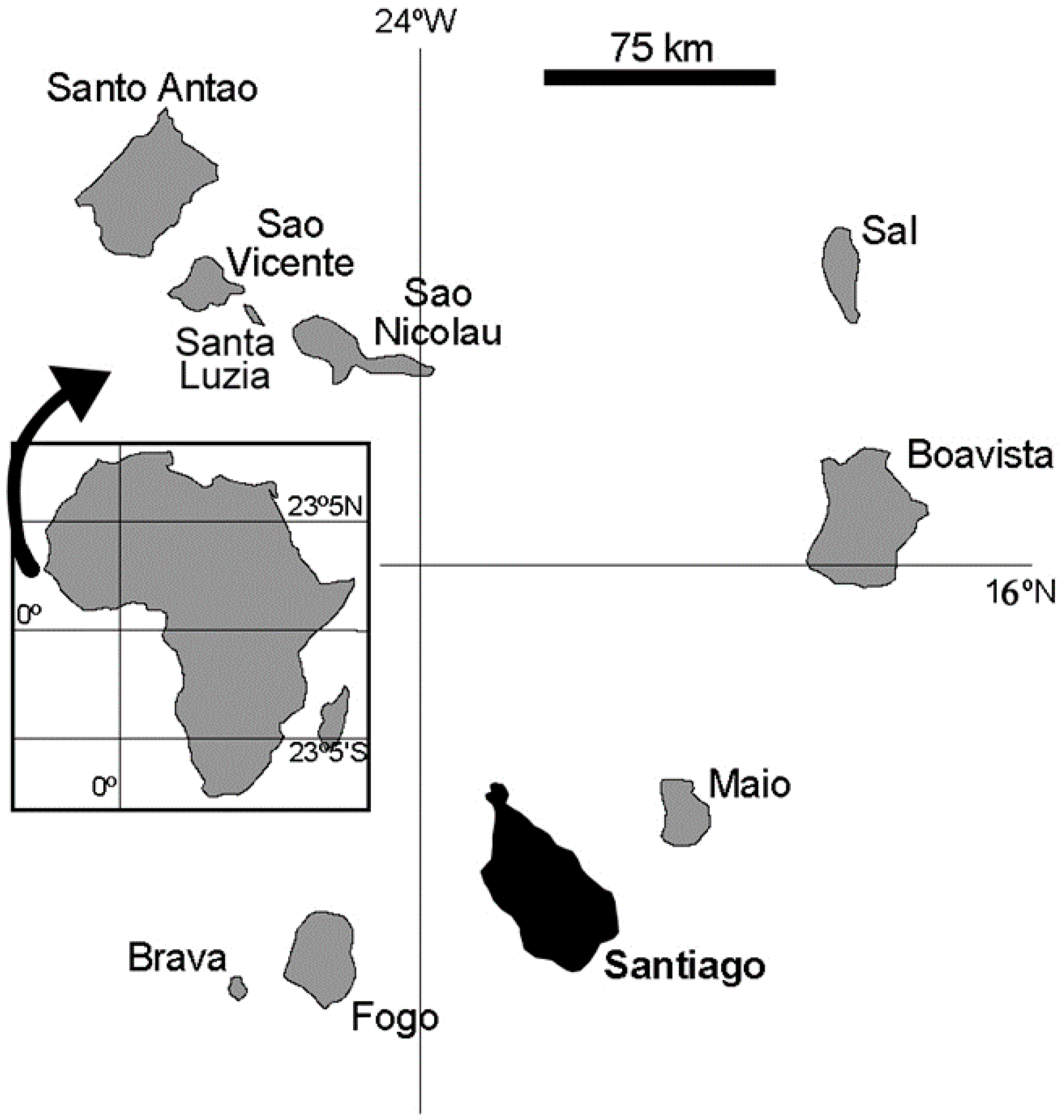
2. Geographic, Geologic, and Climate Settings and Soil Types
3. Methodologies
3.1. Sampling, Chemical, and Statistical Analysis
3.2. Risk Assessment
4. Results and Discussion
5. Conclusions
Supplementary Materials
Acknowledgments
Author Contributions
Conflicts of Interest
References
- Vrščaj, B.; Poggio, L.; Marsan, F.A. A method for soil environmental quality evaluation for management and planning in urban areas. Landsc. Urban Plan. 2008, 88, 81–94. [Google Scholar] [CrossRef]
- Cabral Pinto, M.M.S.; Marinho-Reis, A.P.; Almeida, A.; Ordens, C.M.; Silva, M.M.V.G.; Freitas, S.; Simões, M.R.; Moreira, P.I.; Dinis, P.A.; Diniz, M.L.; et al. Human predisposition to cognitive impairment and its relation with environmental exposure to potentially toxic elements. Environ. Geochem. Health 2017, 3, 1–18. [Google Scholar] [CrossRef] [PubMed]
- Cabral Pinto, M.M.S.; Silva, M.M.V.G.; Neiva, A.M.R. Pollution of water and stream sediments associated with the Vale De Abrutiga Uranium Mine, Central Portugal. Mine Water Environ. 2004, 23, 66–75. [Google Scholar] [CrossRef]
- Neiva, A.M.R.; Carvalho, P.C.S.; Antunes, I.M.H.R.; Cabral Pinto, M.M.S.; Santos, A.C.T.; Cunha, P.P.; Costa, M.M. Spatial variability of soils and stream sediments and the remediation effects in a Portuguese uranium mine area. Chem. Erde-Geochem. 2016, 76, 501–518. [Google Scholar] [CrossRef]
- Wolkersdorfer, C.; Bowell, R. Contemporary Reviews of Mine Water Studies in Europe, Part 3. Mine Water Environ. 2005, 24, 58–76. [Google Scholar] [CrossRef]
- Cabral Pinto, M.M.S.; Dinis, P.A.; Silva, M.M.; Ferreira da Silva, E.A. Sediment generation on a volcanic island with arid tropical climate: A perspective based on geochemical maps of topsoils and stream sediments from Santiago Island, Cape Verde. Appl. Geochem. 2016, 75, 114–124. [Google Scholar] [CrossRef]
- Gray, C.; McLaren, R.; Roberts, A. Atmospheric accessions of heavy metals to some New Zealand pastoral soils. Sci. Total Environ. 2003, 305, 105–115. [Google Scholar] [CrossRef]
- Camobreco, V.J.; Richards, B.K.; Steenhuis, T.S.; Peverly, J.H.; McBride, M.B. Movement of heavy metals through undisturbed and homogenized soil columns. Soil Sci. 1996, 161, 740–750. [Google Scholar] [CrossRef]
- Cabral Pinto, M.M.S.; Silva, M.M.V.G.; da Silva, E.A.F.; Dinis, P.A.; Rocha, F. Transfer processes of potentially toxic elements (PTE) from rocks to soils and the origin of PTE in soils: A case study on the island of Santiago (Cape Verde). J. Geochem. Explor. 2017, 6. [Google Scholar] [CrossRef]
- Mirlean, N.; Roisenberg, A.; Chies, J.O. Metal contamination of vineyard soils in wet subtropics (southern Brazil). Environ. Pollut. 2007, 149, 10–17. [Google Scholar] [CrossRef] [PubMed]
- Silva, M.M.V.G.; Cabral Pinto, M.M.S.; Carvalho, P.C.S. Major, trace and REE geochemistry of recent sediments from lower Catumbela River (Angola). J. Afr. Earth Sci. 2014, 115, 203–217. [Google Scholar] [CrossRef]
- Cabral Pinto, M.M.S.; Silva, M.M.; Neiva, A.M.R.; Guimarães, F.; Silva, P.B. Uranium minerals from a portuguese variscan peraluminous granite, its alteration, and related uranium-quartz veins. In Uranium: Compounds, Isotopes and Applications; Wolfe, G.H., Ed.; Nova Science: New York, NY, USA, 2009; pp. 287–318. [Google Scholar]
- Reis, A.P.M.; Shepherd, T.; Nowell, G.; Cachada, A.; Duarte, A.C.; Cave, M.; Wragg, J.; Patinha, C.; Dias, A.; Rocha, F.; et al. Source and pathway analysis of lead and polycyclic aromatic hydrocarbons in Lisbon urban soils. Sci. Total Environ. 2016, 573, 324–336. [Google Scholar] [CrossRef] [PubMed]
- Shamberger, R.J. Trace Elements in Health: A Review of Current Issues; Rose, J., Ed.; Cambridge University Press: Cambridge, UK, 1983; pp. 167–181. [Google Scholar]
- Centeno, J.A.; Mullick, F.G.; Martinez, L.; Page, N.P.; Gibb, H.; Longfellow, D.; Thompson, D.; Ladich, E.R. Pathology Related to Chronic Arsenic Exposure. Environ. Health Perspect. 2002, 110, 883–886. [Google Scholar] [CrossRef] [PubMed]
- Candeias, C.; Silva, E.F.; Ávila, P.F.; Teixeira, J.P. Identifying sources and assessing potential risk of exposure to heavy metals and hazardous materials in mining areas: The case study of Panasqueira mine (Central Portugal) as an example. Geosciences 2014, 4, 240–268. [Google Scholar] [CrossRef]
- Cabral Pinto, M.M.S.; Silva, E.A.; Silva, M.M.; Melo-Gonçalves, P.; Candeias, C. Environmental Risk Assessment Based on High-Resolution Spatial Maps of Potentially Toxic Elements Sampled on Stream Sediments of Santiago, Cape Verde. Geosciences 2014, 4, 297–315. [Google Scholar] [CrossRef] [Green Version]
- Patinha, C.; Reis, A.P.; Dias, A.C.; Abduljelil, A.A.; Noack, Y.; Robert, S.; Cave, M.; da Silva, E.F. The mobility and human oral bioaccessibility of Zn and Pb in urban dusts of Estarreja (N Portugal). Environ. Geochem. Health 2015, 37, 115–131. [Google Scholar] [CrossRef] [PubMed]
- Reis, A.P.; Costa, S.; Santos, I.; Patinha, C.; Noack, Y.; Wragg, J.; Sousa, A.J. Investigating relationships between biomarkers of exposure and environmental copper and manganese levels in house dusts from a Portuguese industrial city. Environ. Geochem. Health 2015, 37, 725–744. [Google Scholar] [CrossRef] [PubMed]
- Wu, S.; Peng, S.; Zhang, X.; Wu, D.; Luo, W.; Zhang, T.; Zhou, S.; Yang, G.; Wan, H.; Wu, L. Levels and health risk assessments of heavy metals in urban soils in Dongguan, China. J. Geochem. Explor. 2015, 148, 71–78. [Google Scholar] [CrossRef]
- Rayman, M.P. The importance of selenium to human health. Lancet 2000, 356, 233–241. [Google Scholar] [CrossRef] [Green Version]
- Tchounwou, P.B.; Patlolla, A.K.; Centeno, J.A. Carcinogenic and systemic health effects associated with arsenic exposure—A critical review. Toxicol. Pathol. 2003, 31, 575–588. [Google Scholar] [CrossRef] [PubMed]
- Charlet, L.; Polya, D.A. Arsenic in shallow, reducing groundwater in southern Asia: An environmental health disaster. Elements. 2006, 2, 91–96. [Google Scholar] [CrossRef]
- Dissanayake, C.B.; Chandrajith, R. Introduction to Medical Geology Focus on Tropical Environments; Springer: New York, NY, USA, 2009. [Google Scholar]
- Tisserand, D.; Pili, E.; Hellmann, R.; Boullier, A.M.; Charlet, L. Geogenic arsenic in groundwater in the western Alps. J. Hydrol. 2014, 518, 317–325. [Google Scholar] [CrossRef]
- Centeno, J.A.; Finkelman, R.B.; Selinus, O. Medical geology: Impacts of the natural environment on public health. Geosciences 2016, 6, 8. [Google Scholar] [CrossRef]
- Sun, Y.; Zhou, Q.; Xie, X.; Liu, R. Spatial, sources and risk assessment of heavy metal contamination of urban soils in typical regions of Shenyang, China. J. Hazard. Mater. 2010, 174, 455–462. [Google Scholar] [CrossRef] [PubMed]
- Xie, Y.; Chen, T.B.; Lei, M.; Yang, J.; Guo, Q.J.; Song, B. Spatial distribution of soil heavy metal pollution estimated by different interpolation methods: Accuracy and uncertainty analysis. Chemosphere 2011, 82, 468–476. [Google Scholar] [CrossRef] [PubMed]
- Marques, R.; Prudêncio, M.I.; Rocha, F.; Cabral Pinto, M.M.S.; Silva, M.M.V.; Ferreira da Silva, E.A. REE and other trace and major elements in the topsoil layer of Santiago Island, Cape Verde. J. Afr. Earth Sci. 2012, 64, 20–33. [Google Scholar] [CrossRef]
- Cabral Pinto, M.M.S.; Ferreira da, S.E.A.; Silva, M.M.V.G.; Melo-Gonçalves, P. Heavy metals of Santiago Island (Cape Verde) top soils: Estimated Background Value maps and environmental risk assessment. J. Afr. Earth Sci. 2015, 101, 162–176. [Google Scholar] [CrossRef]
- United States Environmental Protection Agency (USEPA). Exposure Factors Handbook 2011. Available online: https://cfpub.epa.gov/ncea/risk/recordisplay.cfm?deid=236252 (accessed on 4 September 2017).
- Almeida-Silva, M.; Almeida, S.M.; Freitas, M.C.; Pio, C.A.; Nunes, T.; Cardoso, J. Impact of Sahara dust transport on Cape Verde atmospheric element particles. J. Toxicol. Environ. Health 2013, 76, 240–251. [Google Scholar] [CrossRef] [PubMed]
- United Nations Development Programme. United Nations Development Program for Cape Verde; United Nations Development Programme: New York, NY, USA, 1993. [Google Scholar]
- Instituto Nacional de Meteorologia e Geofisica (INMG). Climatologic Data of Some Stations in Santiago Island, Praia, Cabo Verde; Internal Report; Instituto Nacional de Meteorologia e Geofisica (INMG): Rome, Itlay, 2005. [Google Scholar]
- CCKP: Climate Change Knowledge Portal. 2015. Available online: http://sdwebx.worldbank.org/climateportal/index.cfm?page=country_historical_climateThisRegion=Africa&ThisCCode=CPV (accessed on 4 September 2017).
- Williams, C.; Hill, I.; Young, R.; White, R.S. Fracture Zones Across the Cape Verde Rise, NE Atlantic. J. Geol. Soc. 1990, 147, 851–857. [Google Scholar] [CrossRef]
- Millet, M.A.; Doucelance, R.; Schiano, P.; David, C.; Bosp, C. Mantle plume heterogeneity versus shallow-level interactions: A case study, the São Nicolau Island, Cape Verde archipelago. J. Volcanol. Geotherm. Res. 2008, 176, 265–276. [Google Scholar] [CrossRef]
- A Geologia da ilha de Santiago (Cabo Verde). Available online: http://memoria-africa.ua.pt/Catalog/ShowRecord.aspx?MFN=41781 (accessed on 4 September 2017).
- Hartemink, A.E.; Krasilnikov, P.; Bockheim, J.G. Soil maps of the world. Geoderma 2013, 207–208, 256–257. [Google Scholar] [CrossRef]
- Hernandez, R.V.A. Caracterização dos Solos da ilha de Santiago (Cabo Verde) Numa Perspectiva de Sustentabilidade Ambiental. Master’s Thesis, Aveiro University, Aveiro, Portugal, 2008. [Google Scholar]
- Faria, X. Os Solos da ilha de Santiago; Est Ens Doc; Junta de Investigações do Ultramar: Lisboa, Portugal, 1970. (In Portuguese) [Google Scholar]
- Carta de zonagem agro-ecológica e de vegetação de Cabo Verde. Available online: http://www.fmsoares.pt/aeb/biblioteca/livro.php?registo=007287 (accessed on 4 September 2017).
- Ministry of the Environment. Soil, Groundwater and Sediment Standards for Use under Part XV.1 of the Environmental Protection Act. Ministry of the Environment. Available online: https://www.ontario.ca/page/soil-ground-water-and-sediment-standards-use-under-part-xv1environmental-protection-act (accessed on 4 September 2017).
- Ministry of Housing, Spatial Planning and the Environment (VROM). Circular on Target Values and Intervention Values for Soil Remediation. The Netherlands Government Gazette, No. 39, Ministry of Housing, Spatial Planning and Environment, Directorate General for Environmental Protection, Department of Soil Protection. Available online: http://www.esdat.net/Environmental%20Standards/Dutch/annexS_I2000Dutch%20Environmental%20Standards.pdf https://cfpub.epa.gov/ncea/risk/recordisplay.cfm?deid=236252; (accessed on 3 September 2017).
- USEPA. United States Environmental Protection Agency. Risk Assessment Guidance for Superfund: Volume III–Part A, Process for Conducting Probabilistic Risk Assessment; EPA 540-R-02-002. 2001. Available online: https://www.epa.gov/sites/production/files/2015-09/documents/rags3adt_complete.pdf (accessed on 4 September 2017).
- USDE. U.S. Department of Energy. The Risk Assessment Information System (RAIS). U.S. Department of Energy’s Oak Ridge Operations Office: Oak Ridge, TN, USA, 2013. Available online: https://rais.ornl.gov/ (accessed on 4 September 2017).
- Rudnick, R.L.; Gao, S. Composition of the Continental Crust. Treatise Geochem. 2003, 3, 659. [Google Scholar] [CrossRef]
- Barnham, K.J.; Bush, A.I. Metals in Alzheimer’s and Parkinson’s diseases. Curr. Opin. Chem. Biol. 2008, 12, 222–228. [Google Scholar] [CrossRef] [PubMed]
- Ahlskog, J.E. The New Parkinson’s Disease, 2nd ed.; Oxford University Press: New York, NY, USA, 2016; p. 544. [Google Scholar]


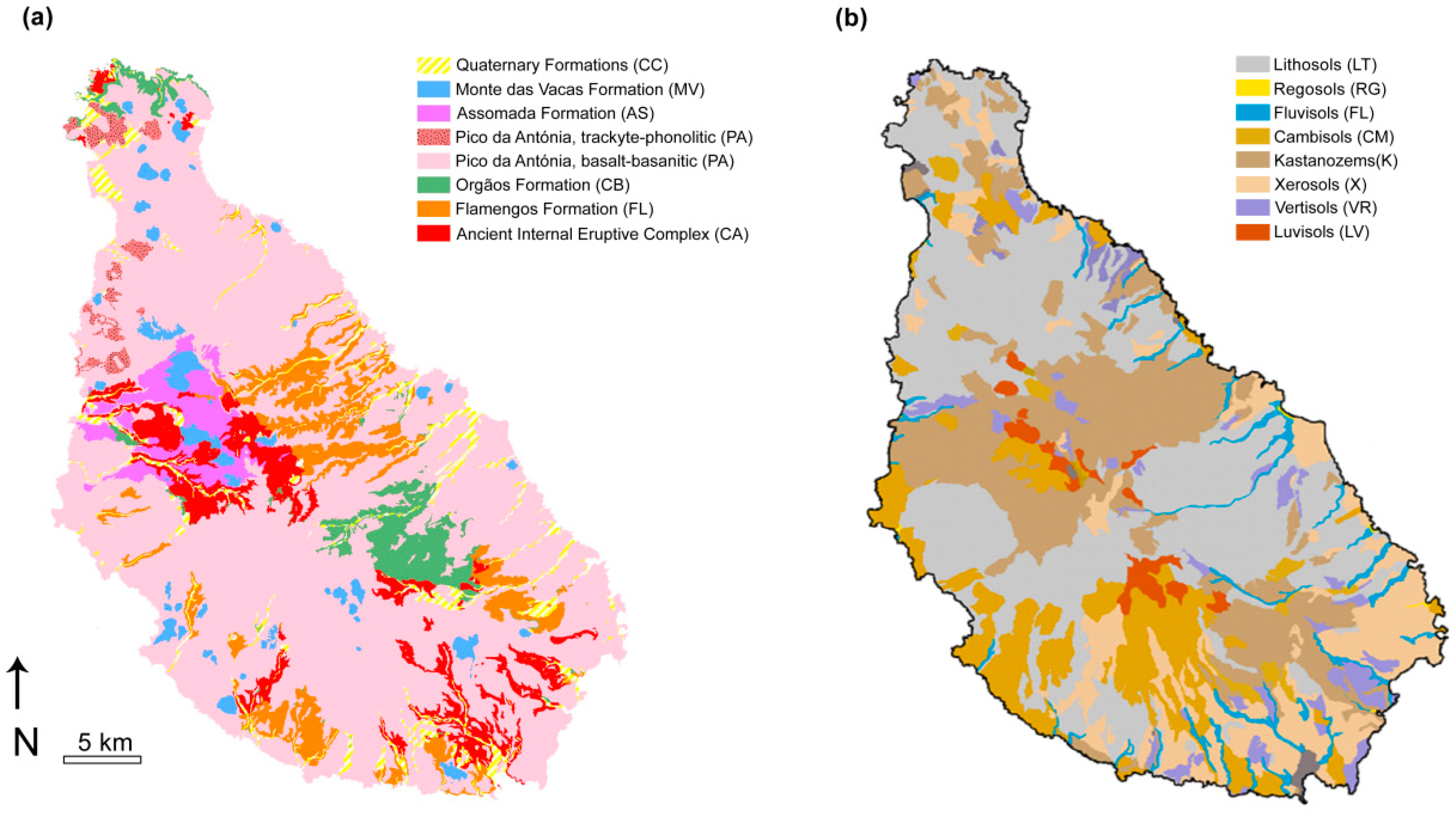
| Geological Formation | Rock Type | Composition |
|---|---|---|
| CA—Ancient Internal Eruptive Complex | Subaerial and submarine lava flows and pyroclastic deposits; dykes and intrusive rocks | Basalts-basanites, phonolites-trachytes and carbonatites |
| FL—Flamengos formation | Submarine lava flows with subordinated breccias and tuffs | Basanites |
| CB—Orgãos Formation | Volcano-sedimentary deposits; rare lava flows | Diverse |
| PA—Pico da Antónia Eruptive Complex | Subaerial and submarine lava flows, dykes and pyroclastic material; intercalated sedimentary deposits | Basalts-basanites and phonolites-trachytes |
| AS—Assomada Formation | Subaerial lava flows and some pyroclastes | Basanites |
| MV—Monte das Vacas Formation | Subaerial pyroclasts and small subordinated lava flows | Basanites |
| CC—Recent sedimentary formations | Alluvial, aeolian, and marine deposits | Diverse |
| Pedological Formation | Development Characteristics | Texture |
|---|---|---|
| LT—Lithosols | Immature incipient mineral soils with no or little differentiation (<20 cm thickness). | Low clay and organic matter contents and high proportion of coarse-grained fractions. |
| RG—Regosols | Incipient mineral and undifferentiated soils. No vegetation. | Mainly sandy and gravel materials. Low clay and organic matter contents. |
| FV—Fluvisols | Undifferentiated or show little differentiation. Developed on alluvial deposits on the banks of temporary or torrential streams. | Mainly sand and coarse particles. |
| CM—Cambisols | Immature (profile AC), non-climate (20–30 cm thickness). | Mainly coarse-to-fine sand with high proportion of slightly weathered rock fragments. |
| K—Kastanozems | Developed soils, but with moderately or poorly differentiated profiles and relatively rich in organic matter. | Fine-grained, mostly consisting of clay materials. |
| X—Xerosols | Sub-arid soils, with surface decalcification horizons and with some organic matter (0.8–1.8%). | Mainly coarse-to-fine material. |
| VR—Vertisols | Non-lytic soils. Developed soils (ABC profile). | Fine-grained, up to 30% clay content. |
| LV— Luvisols | Developed soils (ABC profile). | High proportion of fine-grained particles (mainly clay). |
| EBV 1 | P95(s) 1 | UCC 2 | Guidelines | EBV/UCC | P95(s)/UCC | EBV/Gdl | P95(s)/Gdl | |
|---|---|---|---|---|---|---|---|---|
| As | 0.6 | 1.92 | 4.8 | 11 a | 0.1 | 0.4 | 0.1 | 0.2 |
| Cd | 0.20 | 0.4 | 0.09 | 0.8 b | 2.22 | 4.4 | 1.1 | 0.5 |
| Co | 46.4 | 67.11 | 17.3 | 9 a | 2.7 | 3.9 | 5.2 | 7.5 |
| Cr | 118 | 298 | 92 | 67 a | 1.3 | 3.2 | 1.8 | 4.4 |
| Cu | 50.8 | 81.8 | 28 | 36 b | 1.8 | 2.9 | 1.4 | 2.3 |
| Mn | 1293 | 1954 | 774.5 | - | 1.7 | 2.6 | - | - |
| Ni | 136.1 | 267.9 | 47 | 36 b | 2.9 | 5.7 | 3.8 | 7.4 |
| V | 169 | 260 | 97 | 86 a | 1.7 | 2.7 | 2.0 | 3.0 |
| Zn | 79 | 120.2 | 67 | 140 b | 1.2 | 1.8 | 0.6 | 0.9 |
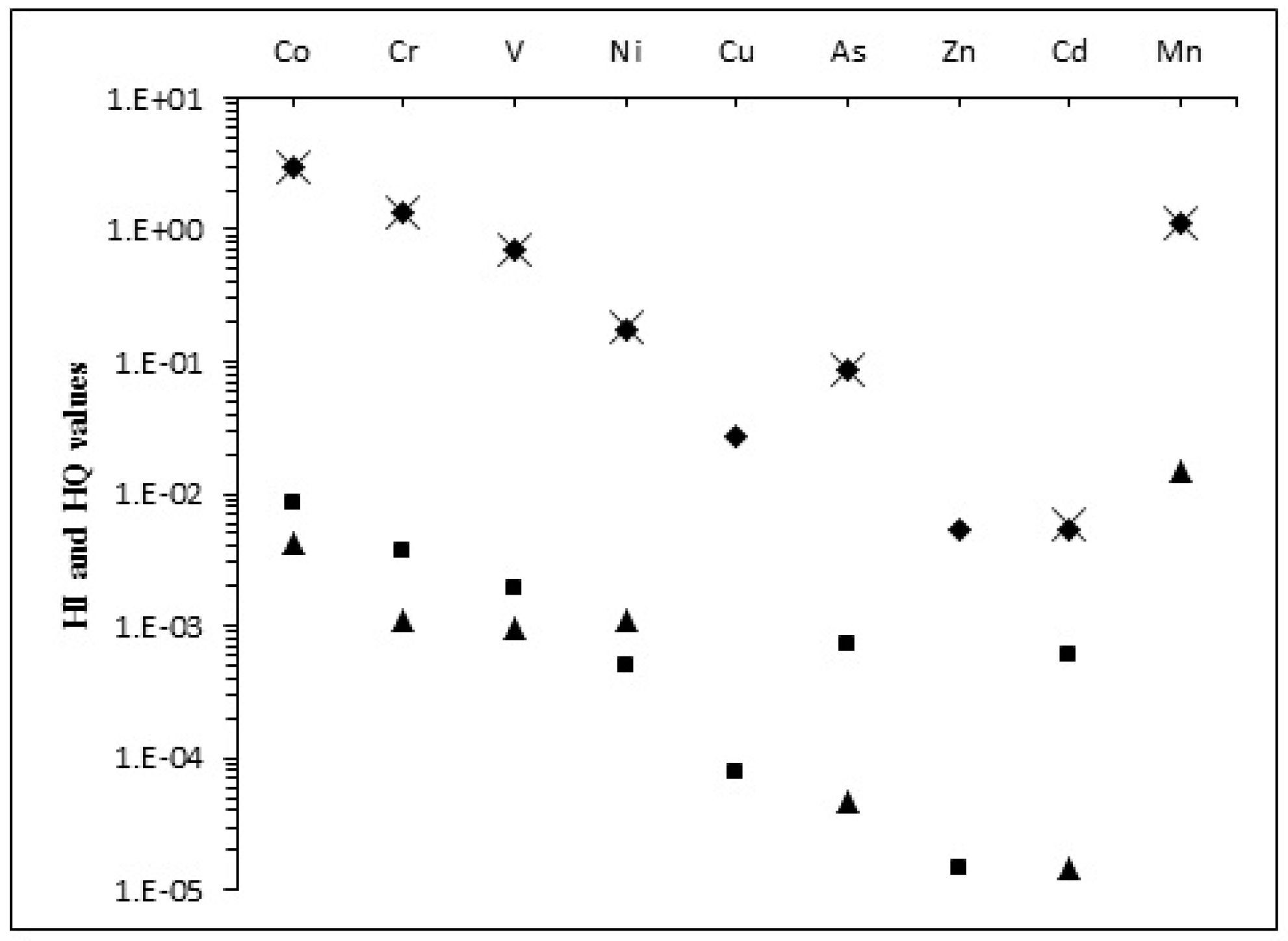
| HQ Ingestion | HQ Dermal | HQ Inhalation | HI | |||||
| Children | Adult | Children | Adult | Children | Adult | Children | Adult | |
| Co | 2.98 | 3.20 × 10⁻¹ | 8.34 × 10⁻³ | 1.28 × 10⁻³ | 4.16 × 10⁻³ | 2.35 × 10⁻³ | 2.99 | 3.23 × 10⁻¹ |
| Cr | 1.32 | 1.42 × 10⁻¹ | 3.70 × 10⁻³ | 5.66 × 10⁻⁴ | 1.11 × 10⁻³ | 6.26 × 10⁻⁴ | 1.33 | 1.43 × 10⁻¹ |
| V | 6.88 × 10⁻¹ | 7.37 × 10⁻² | 1.93 × 10⁻³ | 2.94 × 10⁻⁴ | 9.69 × 10⁻⁴ | 5.46 × 10⁻⁴ | 6.91 × 10⁻¹ | 7.45 × 10⁻² |
| Ni | 1.78 × 10⁻¹ | 1.91 × 10⁻² | 4.98 × 10⁻⁴ | 7.64 × 10⁻⁵ | 1.11 × 10⁻³ | 6.25 × 10⁻⁴ | 1.80 × 10⁻¹ | 1.98 × 10⁻² |
| Cu | 2.72 × 10⁻² | 2.92 × 10⁻³ | 3.04 × 10⁻⁴ | 1.16 × 10⁻⁵ | 7.59 × 10⁻⁷ | - | 2.75 × 10⁻² | - |
| As | 8.44 × 10⁻² | 9.14 × 10⁻³ | 2.36 × 10⁻⁴ | 1.09 × 10⁻⁴ | 4.72 × 10⁻⁵ | 2.69 × 10⁻⁵ | 8.47 × 10⁻² | 9.28 × 10⁻³ |
| Zn | 5.33 × 10⁻³ | 5.72 × 10⁻⁴ | 7.47 × 10⁻⁵ | 2.28 × 10⁻⁶ | 1.49 × 10⁻⁷ | - | 5.41 × 10⁻³ | - |
| Cd | 5.33 × 10⁻³ | 5.71 × 10⁻⁴ | 5.97 × 10⁻⁴ | 9.12 × 10⁻⁵ | 1.49 × 10⁻⁵ | 8.40 × 10⁻⁶ | 5.95 × 10⁻³ | 6.71 × 10⁻⁴ |
| Mn | 1.08 | 1.19 × 10⁻¹ | 3.03 × 10⁻³ | - | 1.45 × 10⁻² | 8.40 × 10⁻³ | 1.10 | 1.27 × 10⁻¹ |
| Cancer Risk Ingestion | Cancer Risk Dermal | Cancer Risk Inhalation | Cancer Risk | |||||
| Children | Adult | Children | Adult | Children | Adult | Children | Adult | |
| As | 3.3 × 10⁻⁹ | 2.1 × 10⁻⁹ | 2.3 × 10⁻¹¹ | 2.6 × 10⁻¹⁰ | 3.1 × 10⁻⁹ | 1.0 × 10⁻⁸ | 6.4 × 10⁻⁹ | 1.2 × 10⁻⁸ |
| Cr | - | - | - | - | 3.9 × 10⁻⁷ | 1.3 × 10⁻⁶ | 3.9 × 10⁻⁷ | 1.3 × 10⁻⁶ |
| Ni | - | - | - | - | 7.2 × 10⁻⁹ | 2.4 × 10⁻⁸ | 7.2 × 10⁻⁹ | 2.4 × 10⁻⁸ |
| Cd | - | - | - | - | 7.8 × 10⁻¹¹ | 2.6 × 10⁻¹⁰ | 7.8 × 10⁻¹¹ | 2.6 × 10⁻¹⁰ |
© 2017 by the authors. Licensee MDPI, Basel, Switzerland. This article is an open access article distributed under the terms and conditions of the Creative Commons Attribution (CC BY) license (http://creativecommons.org/licenses/by/4.0/).
Share and Cite
Cabral Pinto, M.M.S.; Silva, M.M.V.; Ferreira da Silva, E.A.; Marinho-Reis, A.P. The Cancer and Non-Cancer Risk of Santiago Island (Cape Verde) Population due to Potential Toxic Elements Exposure from Soils. Geosciences 2017, 7, 78. https://doi.org/10.3390/geosciences7030078
Cabral Pinto MMS, Silva MMV, Ferreira da Silva EA, Marinho-Reis AP. The Cancer and Non-Cancer Risk of Santiago Island (Cape Verde) Population due to Potential Toxic Elements Exposure from Soils. Geosciences. 2017; 7(3):78. https://doi.org/10.3390/geosciences7030078
Chicago/Turabian StyleCabral Pinto, Marina M. S., Maria M. V. Silva, Eduardo A. Ferreira da Silva, and A. Paula Marinho-Reis. 2017. "The Cancer and Non-Cancer Risk of Santiago Island (Cape Verde) Population due to Potential Toxic Elements Exposure from Soils" Geosciences 7, no. 3: 78. https://doi.org/10.3390/geosciences7030078