Article

SARchaeology—Detecting Palaeochannels Based on High Resolution Radar Data and Their Impact of Changes in the Settlement Pattern in Cilicia (Turkey)

1
Institut für Archäologische Wissenschaften, Universität Bern, Abt. Vorderasiatische Archäologie, Länggass-Strasse 10, 3012 Bern, Switzerland
2
Geographisches Institut, Georg-August-Universität Göttingen, Abt. Kartographie, GIS & Fernerkundung, Goldschmidtstr. 5, 37077 Göttingen, Germany
*
Author to whom correspondence should be addressed.
Geosciences 2017, 7(4), 109; https://doi.org/10.3390/geosciences7040109
Submission received: 22 July 2017 / Revised: 15 October 2017 / Accepted: 16 October 2017 / Published: 24 October 2017
(This article belongs to the Special Issue Remote Sensing and Geosciences for Archaeology)

Abstract

:
The fertile alluvial plain of Cilicia is bordered by the Taurus and Amanus mountain ranges to the west, north and east and the Mediterranean Sea to the south. Since the Neolithic Period, Plain Cilicia was an important interface between Anatolia and the Levant. The alluvial plain is dominated by three rivers: Tarsus, Seyhan and Ceyhan. The avulsion history of the lower course of the rivers Seyhan and Ceyhan during the Holocene remains an unresolved issue. The knowledge about how former river courses have changed is essential for the identification of ancient toponyms with archaeological sites. The analysis of silted up riverbeds based on high-resolution digital elevation models (TanDEM-X) and historic satellite imagery (CORONA) in this paper provide the first indications for the reconstruction of former river channels. Further evidence is given by the evaluation of the settlement patterns from 3rd to 1st millennium BC.

1. Introduction

The changes of river courses, which have had a strong influence on the development of sites and is important for the localization of sites has not been investigated in Cilicia in detail so far. Only the development of river deltas and the changes of the river Tarsus have been studied in detail [1,2,3,4]. For the identification of toponyms known from written sources with archaeological sites, precise knowledge about the changes of river courses is essential. The aim of this paper is a first look at the development of the Seyhan and Ceyhan rivers during the late Holocene. Due to the lack of available coring data, this will be done by the analysis of remote sensing data in combination with a study of changes of the settlement cluster in Plain Cilicia. In southern Mesopotamia, studies about ancient watercourses on which all communication moved and along which all settlement ranged itself were undertaken already in the 1960s and 1970s on the basis of archaeological data and remote sensing data (LANDSAT) [5]. Since then, much more data has become available e.g., CORONA and TanDEM-X. In this study, these archives will be analyzed for the region of Plain Cilicia.
Plain Cilicia (gr. Kilikia Pedias, lat. Cilicia Campestris) covers an area of approximately 8000 km2 in the northeastern corner of the Mediterranean Sea. Like almost no other landscape in Asia Minor, this plain is defined by strong topographic contrasts: a large fertile plain surrounded by steep mountain ranges. The Middle Taurus Range (turk. Orta Toroslar), which exceeds 3700 m in elevation, borders the landscape to the west and north. In the east, the settlement cluster is confined by the Amanos (turk. Nur Dağları) that separates Plain Cilicia from inner Syria and reaches elevations of up to 2200 m. The Gulf of Iskenderun and the Gulf of Mersin form its southern boundary (Figure 1).
Natural passes through the mountains still form the main routes of access to the lowlands. The “Cilician Gates” (turk. Gülek Boğazı) at an elevation of 1290 m connect Anatolia with the plain and serve as the main passageway for railroad tracks and major vehicular roads up until this day. In the westernmost part of Plain Cilicia, forming the transition to Rough Cilicia, the Göksu Valley stretches north–south from the Konya Plain to coastal Silifke and represented an important connection to Anatolia in antiquity [6] (p. 88). The Bahçe Pass (“Amanian Gates”) in the East leads over the Amanus Range and serves as a passage between Cilicia and the Islahiye Plain. Further south, the Orontes Valley can be reached over the Belen Pass (“Syrian Gates”). Access from the north is facilitated by several tributary valleys of the Seyhan and Ceyhan rivers. Late Bronze and Iron Age rock reliefs as well as inscriptions like Hanyeri, İmamkulu, Taşçı and Fraktın [7], mark their significance in antiquity. The plain itself is divided into a western (Çukurova) and an eastern (Yukarıova) settlement cluster by a natural border formed by the foothills of the Middle Taurus Range and the Misis Mountains. The approximately 760 m high Misis Mountains [8] (pp. 305–307) extend northwards from the western end of the Gulf of Iskenderun (Figure 1). The average height of the Çukurova is about 15 m above sea level. The height of the Yukarıova varies from 20–100 m above sea level.
Three main rivers, originating in the Taurus Mountains, cross the lowlands and discharge into the Mediterranean Sea: Berdan or Tarsus Çayı (gr. Kydnos), Seyhan (hitt. Šamri/Sapara, gr. Saros) and Ceyhan (hitt. Puruna, gr. Pyramos) [10] (p. 6). These rivers form the deltaic complex that occupies the Adana Basin (Figure 2). The Adana Basin represents the onshore extension of the marine Cilicia Basin [11] (p. 123). The 6000 m thick sedimentary succession of the Adana Basin is spanning Miocene to Recent [12] (p. 190) and is built by alluvial variable grainsize deposits [13] (p. 135). All rivers are braided in their upper reaches with channel gradients ranging from 1:40 to 1:400, while the channel gradients decrease to >1:2000 in the lower 35–110 km of their courses, causing them to meander [14] (p. 57). The major tributaries of the 560 km long Seyhan are the Göksu, Zamantı, Çakıt and Körkün Rivers [15] (p. 647). Prior to construction of the first dam in 1954 the Seyhan River Delta expanded its area on average by 2.8 ha per year [16] (p. 64). The dam greatly reduced sedimentation in the delta [17] (p. 5). The 510 km long Ceyhan River drains today into the Gulf of Iskenderun and formed a more than 100 km2 large river delta. Paleoenvironmental studies of the Iskenderun Bay show a muddy sedimentation, which coincides with a major delta progradation of the Ceyhan around 2140 BP [18] (p. 20). Therefore, a drainage into the Mediterranean Sea at Kap Karataş during the Iron Age is generally accepted [18] (p. 20).
The course of the coastline underwent major changes. There are a few studies for a reconstruction of the palaeoshorelines available [2,4,14,17,18,20,21,22,23]. A sea level high stand around 6000–5000 BP is generally accepted, followed by a significant regression of the sea level of several meters as well as a slight rise to the modern datum [24]. A mid-Holocene coastline about 5–10 km inland from the present-day coastline is assumed [1,4].
Also from a historical perspective, Plain Cilicia is defined by contrasts between independence and foreign influence up to annexation. During the Chalcolithic Period, there is strong evidence for connections to the Amuq (Figure 1) and other Levantine and north Mesopotamian regions [25]. At the beginning of the Bronze Age, end of the 4th millennium BC, an alteration is visible by a change in the ceramic assemblage and a first orientation to the Anatolian plateau in the north [26] (pp. 141–142), [27]. However, there are still parallels to the Amuq region and the Northern Levant. At the beginning of the 2nd millennium BC, Syro-Cilician Pottery is predominant [28] (p. 11). When Cilicia became the Kingdom Kizzuwatna independent, mid 2nd millennium BC, there is a sudden change in the material evidence, with a strong orientation to the Anatolian plateau visible. From mid-15th to the beginning of the 12th century BC, Kizzuwatna stood under Hittite or Mittani supremacy [28] (p. 36). At the transition from the Late Bronze to the Early Iron Age Plain Cilicia became again independent as the kingdom Ḫiyawa/Que [29]. During the 8th century BC Plain Cilicia was integrated into the Assyrian Empire [30] (pp. 7–24).
The knowledge of the material culture of Kizzuwatna and Ḫiyawa/Que is still fragmentary. Most information come from excavations of the main Bronze and Iron Age sites in the plain. These are from West to East: Mersin-Yumuktepe, Tarsus-Gözlükule, Adana-Tepebağ, Sirkeli Höyük, Tatarlı Höyük and Kinet Höyük (see Figure 3).
Since no archive has been discovered in Cilicia so far, only little is known about the ruling dynasties and the political organization for the Late Bronze and Early Iron Age. Today, the Çukurova is an important agriculture center with high productivity. A dozen archaeological surveys give some evidence about the distribution of settlements in the Çukurova and the Yukarıova. The settlement pattern has not changed fundamentally over the time. Mainly during the Bronze Age and in the Roman Period there is a consolidation of settlement visible. A lack of evidence exist in the foothills of the Taurus Mountains north of Adana as well in an area between the rivers Tarsus and Seyhan (Figure 4).
The historian and geographer Abū l-Fidāʾ (1273–1331) reports [31] (p. 465) that the river Seyhan and Ceyhan join after Misis: “Le Syhan, au-dessous d’Adana et de Messyssa, se joint au Djyhan; tous deux ne forment plus qu’un seul fleuve, qui se jette dans la mer entre Ayas et Tharse” [32] (p. 62f).
The localization of the important classical site Mallos is not clear. It is known that the site must have been close to the river mouth of the Pyramos, the ancient Ceyhan. Forlanini suggest that the site was known in the Late Bronze Age as the harbor town MLWM. He identifies the site at Domuztepe (Seton-Williams No. 74 [26]), situated east of the river Ceyhan, 20 km northeast of the Kap Karataş [10] (p. 12).

2. Materials and Methods

2.1. Settlement Database

To analyze changes in the settlement cluster of Cilicia, a database with the focus on Bronze and Iron Age sites was built. Each site has been documented with its coordinates and its occupation phases (spanning from Neolithic to Ottoman Period). Because less than 3% of the sites have been investigated by excavation it was not possible to provide precise information regarding settlement size during any particular period. Most information for the settlement database was provided by a dozen surveys conducted in the area (Figure 4).
Hetty Goldman (Bryn Mawr Expedition to Cilicia) conducted the first systematic survey in Plain Cilicia in 1934 [33], one year later she started to excavate the site Tarsus-Gözlükule (Figure 3). Excavations were conducted in 1935–1939, 1947–1949 and resumed by Asli Özyar in 2001. The site can securely be identified with Hittite Tarša, know in Neo-Assyrian sources as Tarzu and as Tarsos/Tarsus in Classical Times [10] (p. 4). The Neilson Expedition (1936–1939, 1946–1947) under the direction of John Garstang started to excavate the site Mersin-Yumuktepe (Figure 3) with a sondage in its first year of the survey. The work was resumed by Veli Sevin and Isabella Caneva in 1993. The site might be identified with Hittite Ellipra, Neo-Assyrian Illupru [10] (p. 4).
Tepebağ Höyük, in the center of the present city of Adana, was first excavated with a small sondage in 1936 by the Museum Adana. Recently, excavations have been resumed first by the Çukurova University and later by the Museum of Adana. It can be identified with hitt. Adaniya and classical Antioch on the Saros [29] (pp. 191–195), [34] (p. 154). To gain information about routes through the Taurus Helmuth Theodor Bossert and Bahadir Alkım conducted a survey in the Upper Ceyhan valley from 1945–1952 and in 1955 [35]. They discovered the late Hittite fortress Karatepe-Arslantaş (hitt. Azatiwataya) and started to excavate there in 1946 [36,37,38]. The first and still most comprehensive survey of Plain Cilicia was directed by Marjory Veronica Seton-Williams in 1951 [26]. An important site at the eastern border of the Çukurova, Yakapınar-Misis, was excavated from 1955–1959 by Ludwig Budde and Helmuth Theodor Bossert. In 2000, the work was resumed by Giovanni Salmeri and Ana Lucia D’Agata after conducting a survey in the area. The site might be identified with Zunnaḫara mentioned in Hittite sources [10] (p. 6). In classical time its name was Mopsuhestia and for a short time Seleucia ad Pyramum [34]. Over 400 sites mainly dating from the Classical to the Byzantine Period were investigated by Friedrich Hild and Hansgerd Hellenkemper and published in volume five of the Tabula Imperii Byzantini [34]. Since 1990 Mustafa H. Sayar is conducting an epigraphic survey in the entire region. Marie-Henriette Gates in 1991 and later Ann Killebrew and Gunnar Lehmann (2006–2009) were conducting a survey (Mopsos Survey) along the eastern coast of the Gulf of Iskenderun [39,40]. From 1992–2011 excavations at the harbor site Kinet Höyük under the direction of Marie-Henriette Gates were undertaken. The site can be identified with Hittite Izziya and classical Issos [41]. Only 15 km upstream of Yakapınar-Misis is the site Sirkeli Höyük located. Excavations started in 1936–1937 by John Garstang as part of the Neilson Expedition. Later Excavations were directed by Barthel Hrouda 1992–1996 and Horst Ehringhaus (1997). The work was resumed in 2006 by Mirko Novák, Ekin Kozal and Deniz Yaşin Meier [42]. There is strong probability to identify Sirkeli Höyük with Kummanni known from Hittite religious texts [10]. A neighboring cult city to Kummanni was the site Lawazantiya/akkad. Lusanda. The site of Tatarlı Höyük is a strong candidate for its identification. Excavations have started in 2007 by K. Serdar Girginer [43].
Information from written sources have been added to the database with up to 1000 sites when available.

2.2. CORONA Satellite Imagery

A total of 19% of the sites in the settlement database are not visible on modern satellite imagery anymore and 76% are damaged. However, many of these archaeological sites are still visible on historical satellite imagery. Declassified in 1995, CORONA satellite images (Figure 5) acquired by the United States from 1958–1972 [44] have been used in addition to Digital Elevation Models to map palaeochannels in Plain Cilicia. The CORONA images are valuable because they were acquired before the intensification of the agriculture and the growth of urban areas. Some of the sites were destroyed due to the erecting of dams [45,46]. Images from different missions with the camera systems KH-4A and KH-4B were analyzed (Figure 5). The images have an average spatial resolution of 1.8 m [47] (p. 119). For images of the mission DS1107, orthorectified images of the CORONA Atlas of the Middle East were used (Center for Advanced Spatial Technologies, University of Arkansas/U.S. Geological Survey; [48]). To remove geometric distortion of the images from further missions (DS1043, DS1101, DS1103, DS1105, DS1109) the CORONA software written by Irwin Scollar was used [49]. The georeferencing was done with ArcGIS v. 10.2 (3rd Order Polynomial). The identification of archaeological sites and geomorphic features on CORONA imagery was performed visually.

2.3. TanDEM-X: TerraSAR-X Add-on for Digital Elevation Measurement

The TanDEM-X system is a space borne radar interferometer that is based on two satellites (TerraSAR-X 3) orbiting in close formation [50]. The high resolution X-band SARs (9.65 GHz) can be operated in different imaging modes (High Resolution Spotlight, Stripmap, ScanSAR). For this study, two TanDEM-X acquisitions were made possible in two different imaging modes at horizontal polarization. In Stripmap (SM) mode the course of the Ceyhan River was covered at an azimuth resolution of 2.54 m. The High Resolution Spotlight (HS) mode enabled the registration of a smaller area of interest (approx. 5 × 5 km2) at a nominal resolution of 1.13 m in azimuth (see [51] for a detailed description of image processing). In addition to TanDEM-X, other freely available DEM products from the shuttle radar topography mission (SRTM C-band version 4.1 with 90 m resolution, SRTM X-band with 30 m resolution) as well as the ASTER Global DEM (V.2) were used to generate a high resolution DEM-mosaic (Figure 6). The global spatial resolution is 5 m. 55% of the area are covered by TanDEM-X data divided into 8 spotlight and 22 stripmap scenes. The accuracy of the height value is 4.65 m on average with a standard deviation of 3.82 m [45]. The TanDEM-X DEM mosaic provided the basis for the extraction of cross sections of height values (profiles) for the detailed analysis of the topography across riverbeds and paleochannels (Figure 6).
In addition, VHR (very high resolution) satellite images in GoogleEarth and ArcGIS were visually analyzed.

3. Results

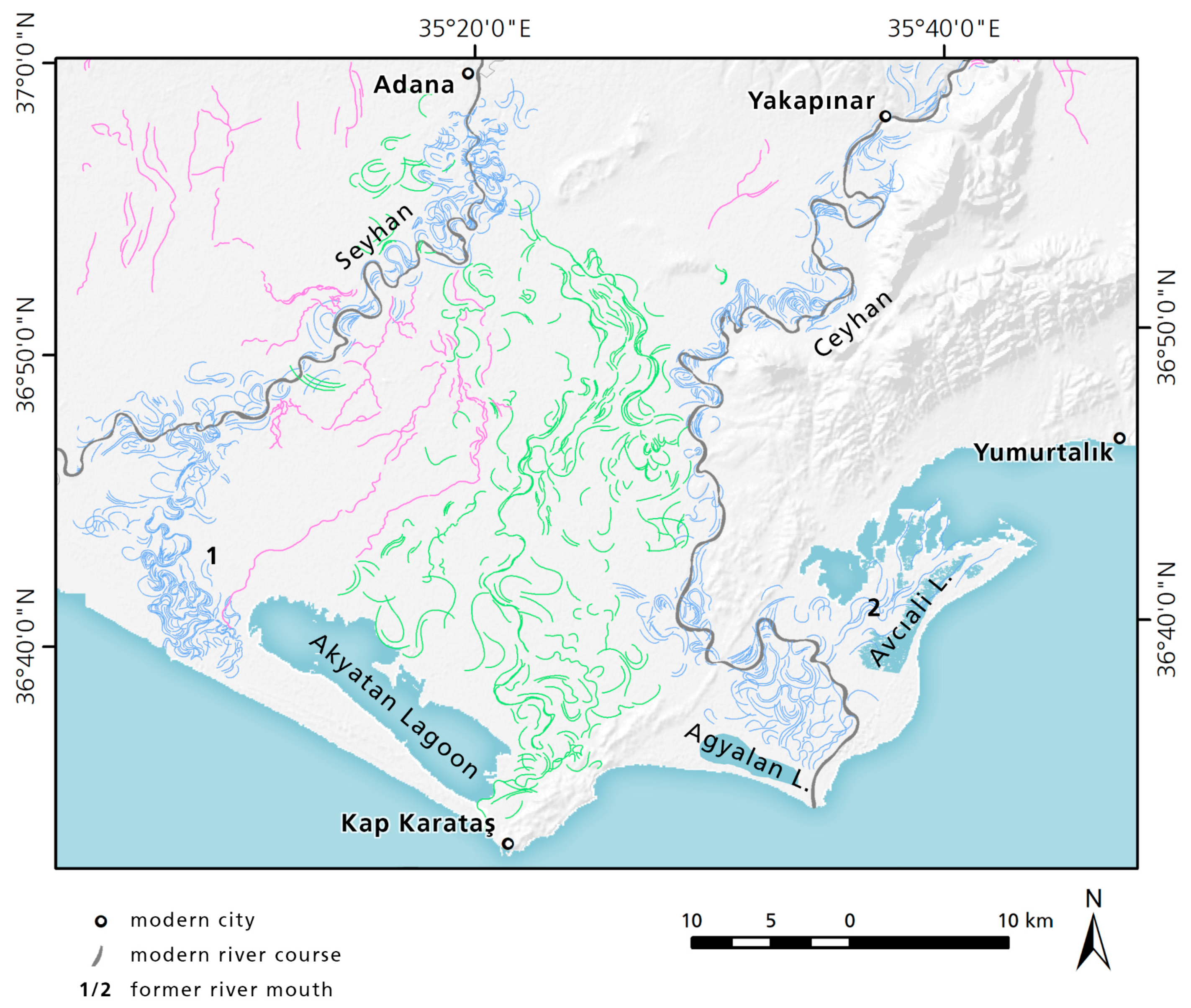
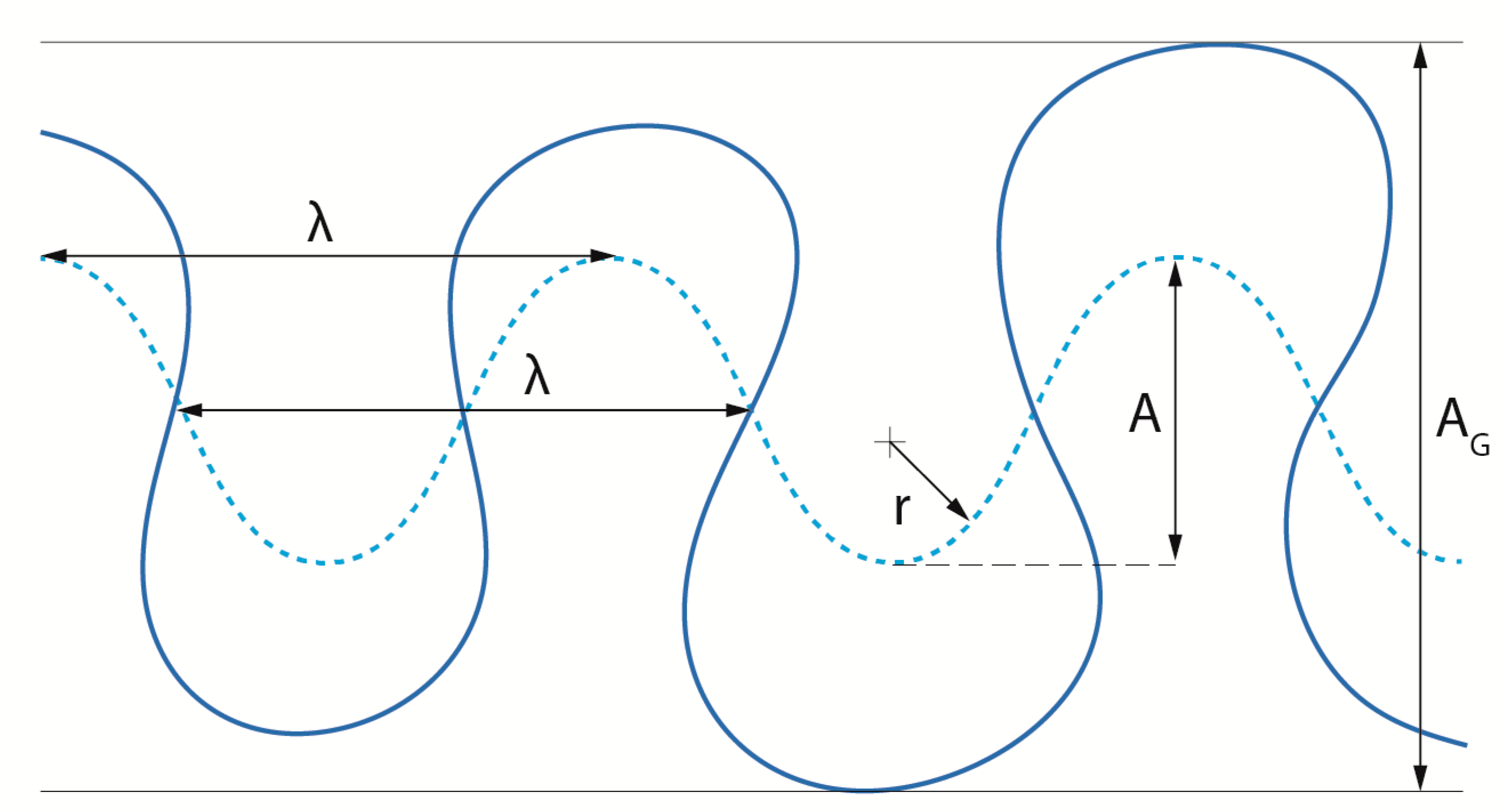
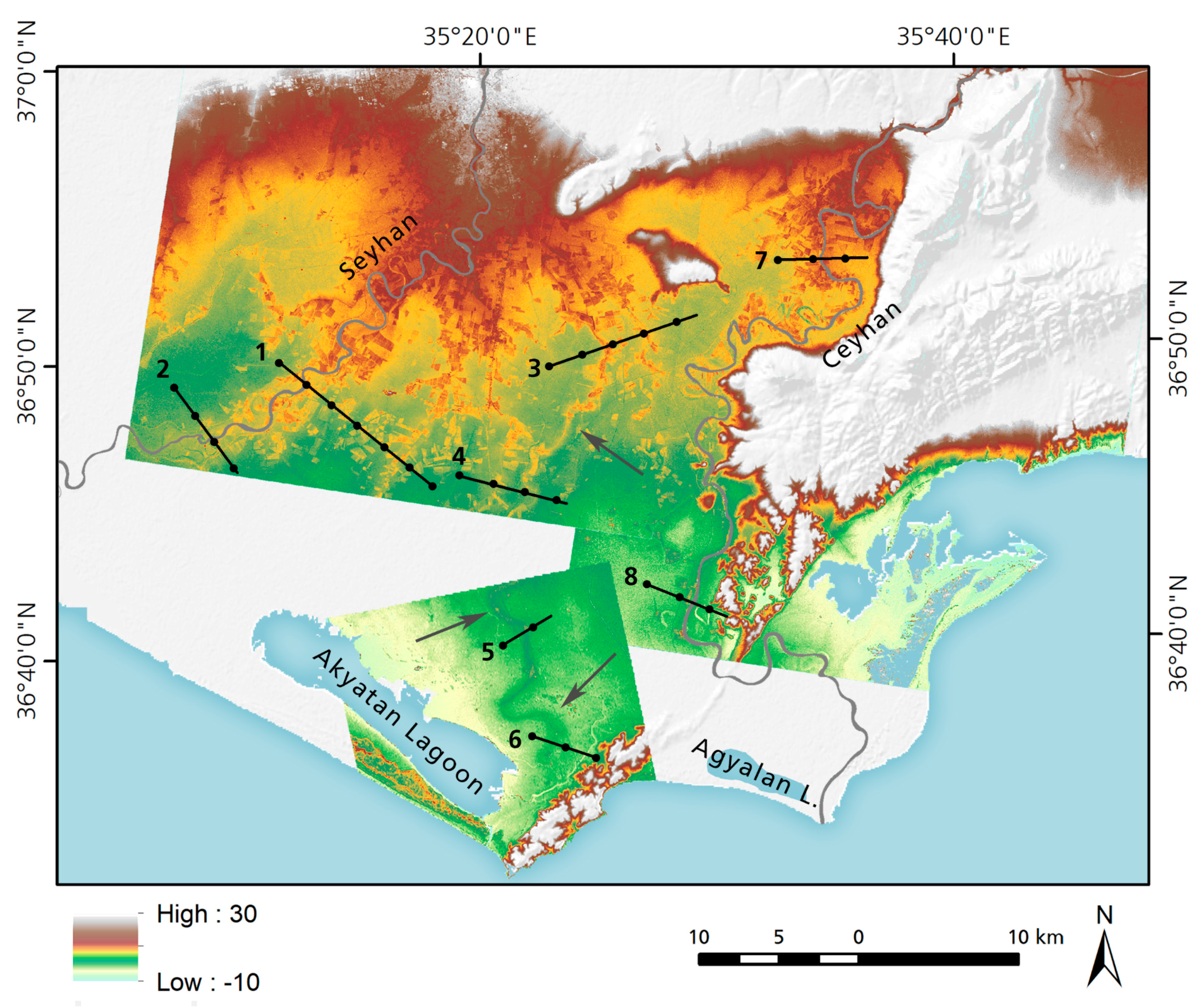
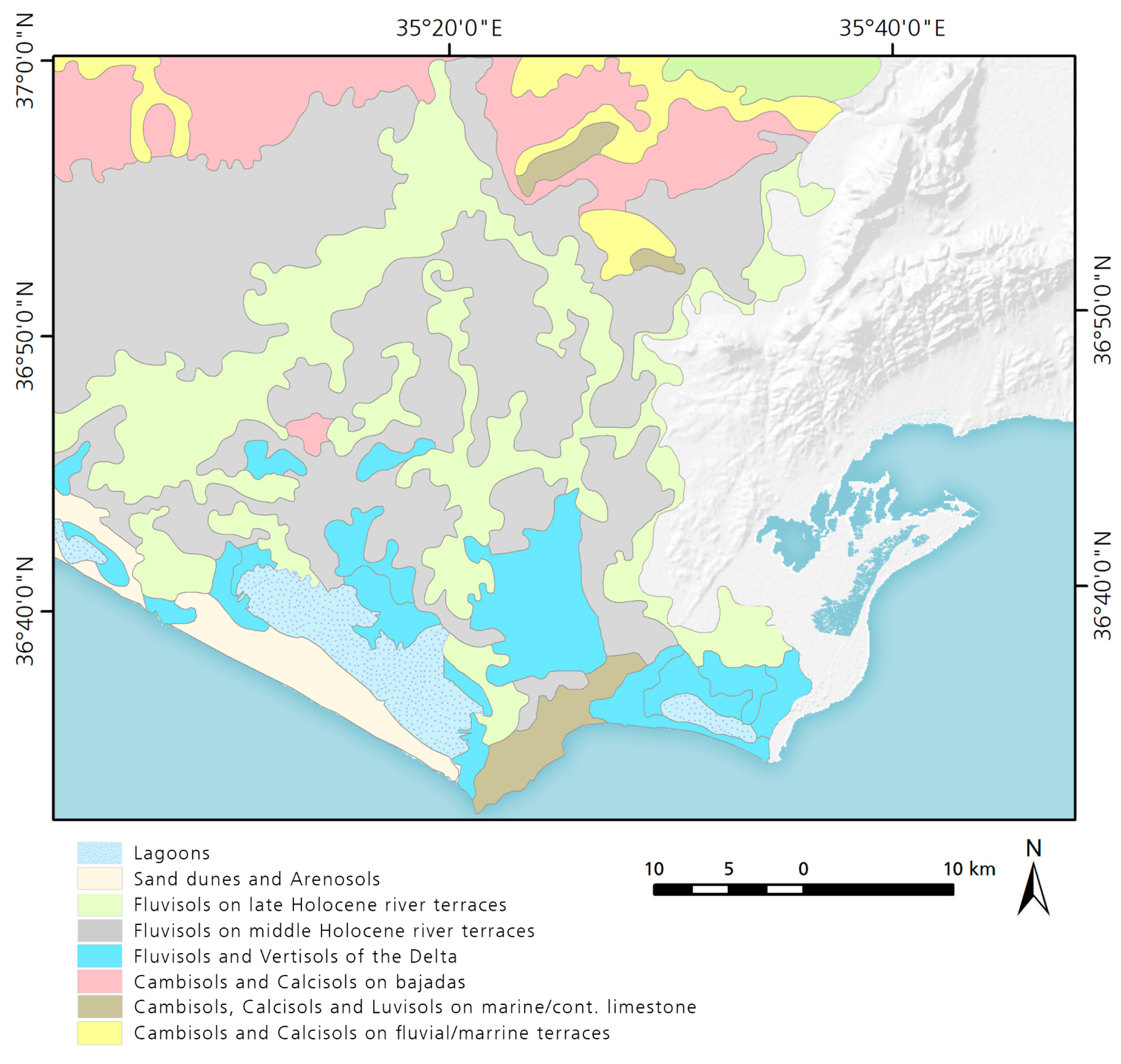
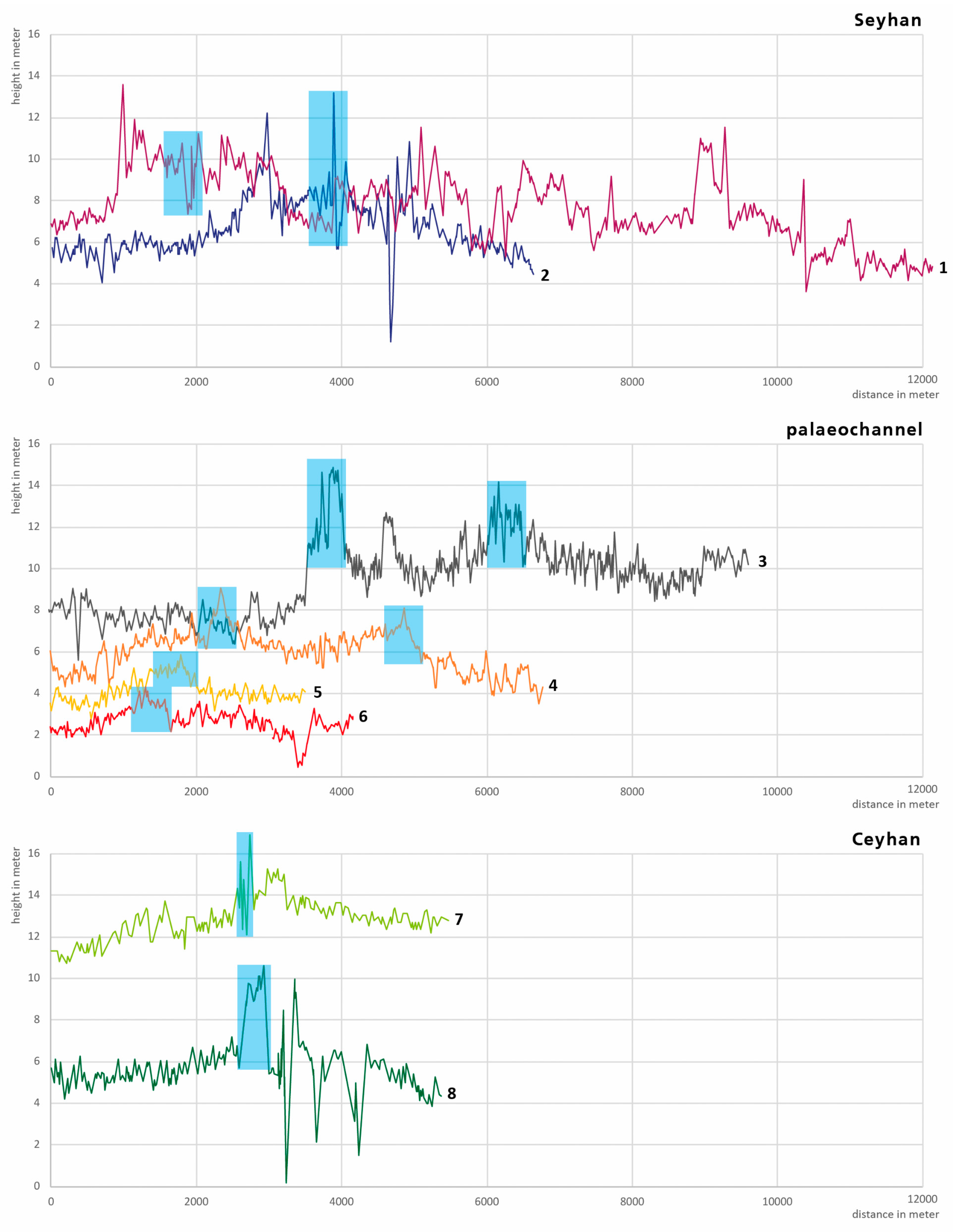
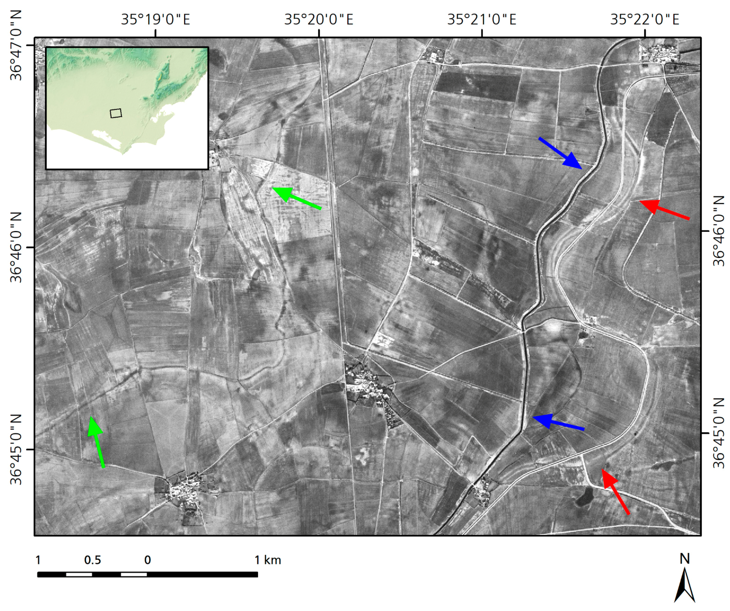
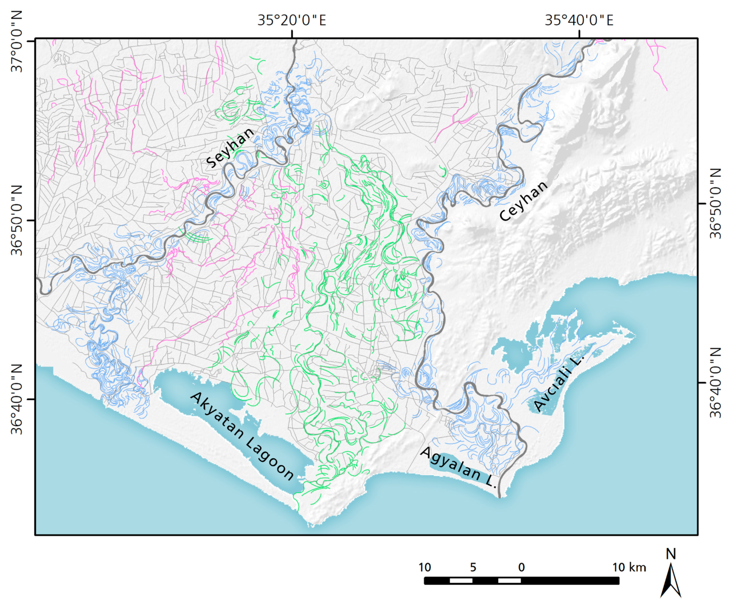
3.1. Palaeochannels and Relict Canals

Palaeochannels are sections of abandoned channels [52]. They become fully or partly infilled by abandoned channel accretion [53] (p. 136). Palaeochannels are most commonly preserved as exposed cross-sections, abandoned surface forms, or buried channels [54]. They were mapped based on the analysis of geomorphic features visible in CORONA satellite imagery from the 1960s, high resolution DEM-data and freely available VHR satellite images (Figure 7, palaeochannels in blue and green color).
Relict canals are abandoned canals for irrigation. They can be traced by their pattern in modern fields and the remains of ancient levees [55] (p. 289) (Figure 7, relict canals in pink color).
Since most of the palaeochannels were found between today’s river course of Seyhan and Ceyhan, this area will be discussed here.
Not all palaeochannels are visible on aerial or satellite imagery. Older channels are buried beneath more recent sediments. However, the mapped palaeochannels show different morphologies. The idealized river course corresponds to a sine curve [56] (p. 147) (Figure 8).
The sinuosity ratio gives an indication how much a river meanders by measuring the length of a channel reach and dividing this by the straight line distance [53] (p. 138). Rivers in a flat plain follow a winding path where the meander amplitude (A) is higher than the meander wavelength (λ) (Figure 8). This can be seen exemplary in the Çukurova about one kilometer east and west of the rivers Seyhan and Ceyhan. The blue palaeochannels (Figure 7) show the most recent abandoned channels. The former Seyhan river mouth, active until 1000 AD, is clearly visible with a high sinuosity ratio (Figure 7, No. 1) [1,21]. A more recent alteration of the Ceyhan River seems to have occurred at the beginning of the 20th century. From the Middle Ages until 1935, the Ceyhan River mouth diverted eastwards [2] (Figure 7, No. 2), thus its present-day location is situated west of where it had been in medieval times [15] (p. 656).
Less meandering structures with a lower sinuosity ratio show the green palaeochannels (Figure 7). They are located west of the river Ceyhan but belong to a former river course of the Seyhan as DEM-data show. A main channel of this former river course can be traced up to 7 km before the coastline northeast of the Akyatan Lagoon (Figure 9).
The data of the high resolution TanDEM-X DEM allow the generation of cross sections (Figure 10). The large palaeochannel is visible as a positive height anomaly, which is formed by natural levees. Deposition of fine sand, silt and clay alongside and within the channels results in the aggradation of levees which gradually raise the rivers until they flow several meters above the plain on low ridges. As cross sections of the modern Seyhan and Ceyhan rivers show, their riverbed is located 2–4 m above the plain as well (Figure 10).
The construction of canals for irrigation results in levees as well. In addition, channel excavation and cleaning operations result in the up-cast of clean-out banks alongside the canal [57] (p. 415), [58] (p. 339). Compared to palaeochannels, (relict) canals show a less meandering course with a low sinuosity ratio. The course of presumed canals was mapped in pink (Figure 7). The spoil banks are visible on optical imagery as CORONA representing white lines bordered the canal (Figure 11). Relict canals itself can be identified as darkened depressions, filled with moist sediments [59]. Water flowing in active canals has a dark signature as well (Figure 11).

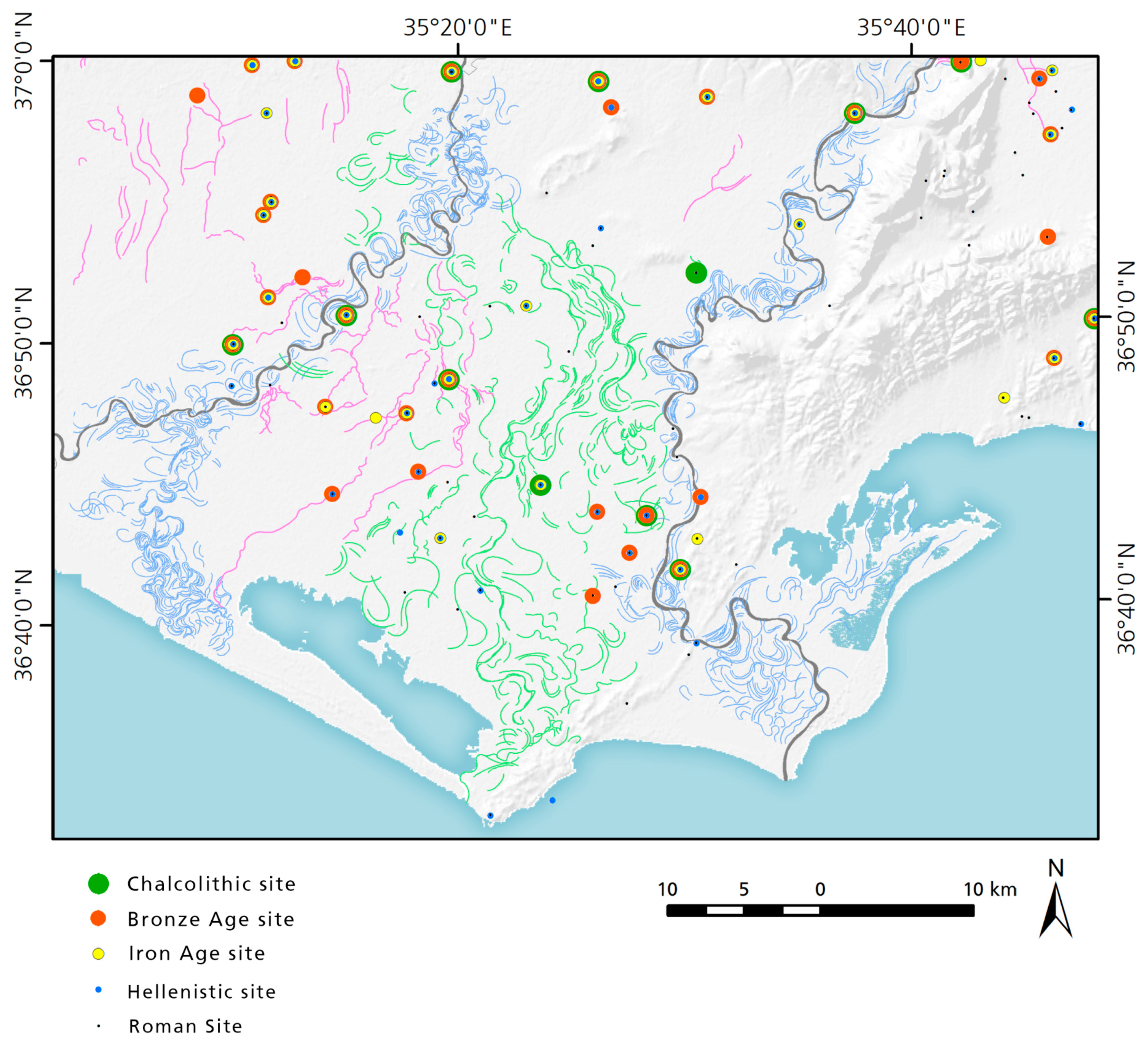
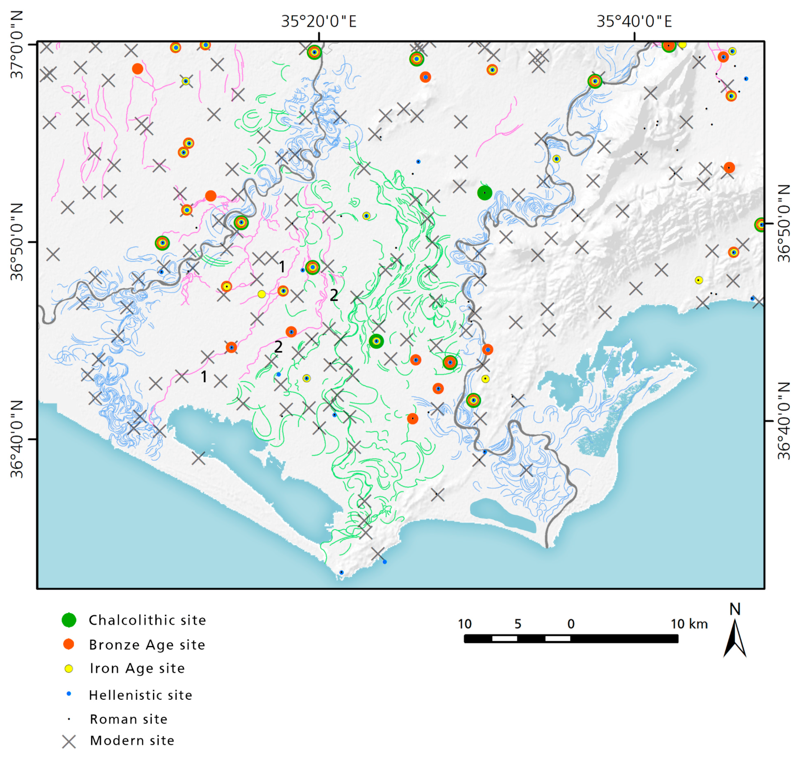
3.2. Distribution of Archaeological Sites in the Area

Even though for precise dating of palaeochannels and relict canals coring and the analysis of sediment is necessary, the location of archaeological sites give some evidence about the dating of these relict canals and palaeochannels (Figure 12).
First, a relation between the age of an archaeological site and its distance to the modern coastline can be observed. The older a site the farther it is situated from the sea. In this area, the closest chalcolithic sites are in distance of 18–20 km to the shoreline. These are Dervisli (Seton-Williams No. 135 [26]) and Domuz III (Seton-Williams No. 102 [26]). While the closest Bronze Age site Gavur Köy (Seton-Williams No. 119 [26]) is only 13 km from today’s coastline located. The known Iron Age sites are located in a similar distance to the shoreline. Sites dating to the Roman Period are located right behind the Akyatan Laggon and at the Kap Karataş (Magarsos [60]). These settlement distributions give an idea about shifts of the coastline.
In the area of the large palaeochannel, there is only one site (Domuz III, Seton-Williams No. 102 [26]) dating to the Chalcolithic period known. However, several sites dating to Hellenistic and Roman period are situated close to the palaeochannels (Figure 12, mapped in green). We assume the danger of flooding during the Chalcolithic Period affected this distribution. The accumulation of sediments and the ideal slope for irrigation were the preconditions for sites in later periods. Sites on natural levee ridges were first occupied after these landforms were already developed and no longer subject to flooding [61].
Several sites dating mainly from Bronze Age to the Roman Period are situated along relict canals (mapped in pink). Therefore, the canals have to be in use since the Bronze Age.

4. Discussion

4.1. Dating of Palaeochannels and the Relict Canals

A soil survey of the Çukurova University [62] show that the palaeochannels mapped in Figure 7 correspond to late Holocene river terraces while the surrounding plain was built during the middle Holocene (Figure 13). The late Holocene river terraces spread in the area between today’s river course of Seyhan and Ceyhan.
Additionally, the mapping of former river delta soils give some evidence of former location of the coastline (Figure 13). Fluvisols and Vertisols of the delta reach up to 20 km inland.
Based on the data of the soil survey of the Çukurova University (Figure 13) and the presence of Bronze Age sites along relict canals (Figure 12) we propose that the river Seyhan followed already in the Bronze Age (3rd and 2nd millennium BC) a western course like today (Figure 14). The intake of the relict canals must have been located west of the supposed former course of the large palaeochannel (mapped in green, Figure 12). Therefore, the large palaeochannel must date before the Bronze Age, possibly in the Neolithic (9th–7th millennium BC) or Chalcolithic Period (6th–4th millennium BC). However, a shared river mouth in previous times of former Seyhan and Ceyhan rivers—as authors in Antiquity like Pseudo-Scylax or in Medieval times like Abū l-Fidāʾ reported [31] (p. 465)—is conceivable for the time when the large palaeochannel was active.
The Late Bronze Age harbor town MLWM could have been a river harbor situated east of the river Ceyhan likely identified with the archaeological site Domuztepe [10] (p. 12). Figure 14 shows a preliminary reconstruction of the palaeo-landscape from the mid to the late Holocene.
Today, several modern sites are located along a modern canal following the western relict canal (Figure 15, No. 1). However, there are no modern sites located along the eastern relict canal (Figure 15, No. 2). Therefore, the eastern relict canal must have been in use during previous periods. Since several sites dating to the Bronze Age are located along these relict canals it is possible that they were in use from the Bronze Age to Roman Times.

4.2. Irrigation System

The average annual rainfall in the Çukurova is over 750 mm/year [63]. This rate is high enough for rainfed agriculture. Supplementary irrigation systems increase the productivity of rainfed areas. Due to its fertile alluvial soils and mild climate, the Çukurova produce high crop yields twice a year. This makes the region an important contributor to the gross value of Turkeys agricultural crop production of 5% in 1995 [63]. In antiquity the region was famous for agricultural products [34] (pp. 109–111).
A large limestone statue of a male bearded figure standing on a basalt basis showing a chariot pulled by two bulls was found 1997 in Çineköy (Figure 3), a village in the middle of the Çukurova [64]. The male figure represents a god, who must be identified with the Storm-god Tarhunzas. A bilingual inscription in Luwian and Phoenician is engraved in the monument [64,65,66]. The more than 2.50 m high monument is shown today in the Museum Adana. The inscription is formed of two main parts: an introduction dedicated to the self-presentation of the king and a longer section describing the king’s achievements [66]. The king praise himself: “I caused the plain of Hiyawa to prosper” [66] (p. 187). He named the plain also as “land of the rivers” [64] (p. 972). There is no large Late Bronze Age site in vicinity known which would explain the location of such monument. However, the find spot is located at a relict canal. Therefore, it might by possible that the monument was erected at an artificial canal. Additional irrigation must have used already during the Late Bronze and Iron Age.
The overlay of the modern canal network for irrigation with mapped relict canals and palaeochannels show that the course of modern canals corresponds to relict canals and palaeochannels (Figure 16). Today, most canals in the Çukurova are constructed with concrete slabs. Many canals have a meandering course even though a straight channel network would be more effective and reduce the number of necessary channels. Thus, the ideal slope of the palaeochannels was followed when constructing modern canals.

4.3. The Advantage of High Resolution DEM Data for Archaeology

Only a few archaeological sites are published with their coordinates. Therefore, we needed additional information for the precise localization of the sites for the settlement database. The CORONA imagery was an important source of information. Still, small sites were not always visible on this historic satellite imagery. For such cases, the TanDEM-X based height model was an important addition. A low elevated hill can be still visible in a height model while it is not visible anymore on optical data.
Large palaeochannels can be detected easily and even smaller palaeochannels can be uncovered with a stretched color ramp. High resolution DEM-data helps not only to detect features. It is also possible to take precise measurements. The data allows generating cross section to make small differences in height of 1 m visible. Nevertheless, it does not replace ground truthing.

5. Conclusions

The combined use of remote sensing data, soil surveys and archaeological data are first indications for the reconstruction of ancient river courses, when there is only limited coring available. Based on the available data we assume a more eastern course of the river Seyhan during the early or middle Holocene/the Neolithic Period. A major avulsion took place during the late Neolithic or Chalcolithic Period. This shift of the river Seyhan to the west must have an influence to the distribution of sites. In comparison to southern Mesopotamia, where major shifts of rivers were leading to depopulation of large areas, the consequences in the Çukurova might have been less drastic. While irrigation was essential for agriculture in southern Mesopotamia farmers in the Çukurova could still rely on rainfed agriculture for their subsistence. The influence of channel avulsion on settlement must be further investigated.
Today, the landscape of the Çukurova is structured from a bird’s eye view by the agricultural area as well as modern river beds, irrigation canals and channel avulsion. Despite the meandering character of palaeochannels modern irrigation canals still follow their course. The location of archaeological sites along both relict canals and modern irrigation canals demonstrate that irrigation canals are in use—maybe not continuous—over a very long period. The finding of such a big monument as the Çineköy statue close to a relict canal gives further evidence for the use of irrigation in this area at least since the Late Bronze Age.
However, the limitations of this study can only be overcome by further investigations. The analysis of drilling cores along transects to get information about the past shifts of the coastline and the sedimentation history of the Ceyhan and Seyhan rivers is necessary.

Acknowledgments

All TanDEM-X data were kindly provided by German Aerospace Center (DLR) within the project “The potential of Tandem-X DEM data for archaeological prospection—case studies in Plain Cilicia, Turkey” (project ID: OTHER0340).

Author Contributions

Susanne Rutishauser and Ralph Rosenbauer designed the concept for the case study. Ralf Buchbach and Stefan Erasmi performed the processing of the TanDEM-X data. Susanne Rutishauser analyzed the data and wrote the paper. All authors contributed to the discussion of the results.

Conflicts of Interest

The authors declare no conflict of interest.

References

  1. Gürbüz, K. An example of river course changes on a delta plain: Seyhan Delta (Cukurova plain, southern Turkey). Geol. J. 1999, 34, 211–222. [Google Scholar] [CrossRef]
  2. Erol, O. Ceyhan Deltasinin Jeomorfolojik Evrimi: Geomorphological Evolution of the Ceyhan River Delta: Eastern Mediterranean Coast of Turkey. Aegean Geogr. J. 2003, 12, 58–81. [Google Scholar]
  3. Mahmoud, Y.; Masson, F.; Meghraoui, M.; Cakir, Z.; Alchalbi, A.; Yavasoglu, H.; Yönlü, O.; Daoud, M.; Ergintav, S.; Inan, S. Kinematic study at the junction of the East Anatolian fault and the Dead Sea fault from GPS measurements. J. Geodyn. 2013, 67, 30–39. [Google Scholar] [CrossRef]
  4. Öner, E.; Hocaoğlu, B.; Uncu, L. Palaeogeographical Surveys around the Mound of Gözlükule (Tarsus). In Field Seasons 2001–2003 of the Tarsus-Gözlükule Interdisciplinary Research Project; Özyar, A., Ed.; Ege Yayınları: İstanbul, Turkey, 2005; pp. 69–82. [Google Scholar]
  5. Adams, R.M. Heartland of Cities. Surveys of Ancient Settlement and Land Use on the Central Floodplain of the Euphrates; The University of Chicago Press: Chicago, IL, USA, 1981. [Google Scholar]
  6. Newhard, J.M.L.; Levine, N.; Rutherford, A. Least-Cost Pathway Analysis and Inter-Regional Interaction in the Göksu Valley, Turkey. Anatol. Stud. 2008, 58, 87–102. [Google Scholar] [CrossRef]
  7. Ehringhaus, H.; Starke, F. Götter, Herrscher, Inschriften. Die Felsreliefs der Hethitischen Grossreichszeit in der Türkei; Philipp von Zabern: Mainz, Germany, 2005. [Google Scholar]
  8. Schiettecatte, J.P. Geology of the Misis Mountains. In Geology and History of Turkey; Campbell, A.S., Ed.; Petroleum Exploration Society of Lybia: Tripoli, Libya, 1971; pp. 305–315. [Google Scholar]
  9. Jarvis, A.; Reuter, H.I.; Nelson, A.; Guevara, E. CGIAR-CSI SRTM 90 m Database. Hole-filled SRTM for the Globe Version 4. 2008. Available online: http://srtm.csi.cgiar.org (accessed on 18 October 2017).
  10. Forlanini, M. How to infer ancient roads and itineraries from heterogeneous Hittite texts: The case of the Cilician (Kizzuwatnean) road system. Riv. Stor. Ambient. Cult. Vicino Oriente Antico 2013, 10, 1–34. [Google Scholar]
  11. Aksu, A.E.; Calon, T.J.; Hall, C.J.; Mansfield, S.; Yaşar, D. The Cilicia–Adana basin complex, Eastern Mediterranean: Neogene evolution of an active fore-arc basin in an obliquely convergent margin. Mar. Geol. 2005, 221, 121–159. [Google Scholar] [CrossRef]
  12. Burton-Ferguson, R.; Aksu, A.E.; Hall, C.J. Seismic stratigraphy and structural evolution of the Adana Basin, eastern Mediterranean. Mar. Geol. 2005, 221, 189–222. [Google Scholar] [CrossRef]
  13. Isola, I.; Bini, M.; Ribolini, A.; Zanchetta, G.; D’Agata, A.L. Geomorphology of the Ceyhan River lower plain (Adana Region, Turkey). J. Maps 2017, 13, 133–141. [Google Scholar] [CrossRef]
  14. Aksu, A.E.; Ulug, A.; Piper, D.; Konuk, Y.T.; Turgut, S. Quaternary sedimentary history of Adana, Cilicia and Iskenderun Basins: Northeast Mediterranean Sea. Mar. Geol. 1992, 104, 55–71. [Google Scholar] [CrossRef]
  15. Akbulut, N.; Bayarı, S.; Akbulut, A.; Şahin, Y. Rivers of Turkey. In Rivers of Europe; Tockner, K., Ed.; Elsevier: Amsterdam, The Netherlands, 2009; pp. 643–672. [Google Scholar]
  16. Bal, Y.; Çetin, H.; Demirkol, C. An update on the coastline changes and evolution of the Seyhan and Ceyhan Deltas in the Northeast Mediterranean, Turkey. In Proceedings of the International Symposium on Geology and Environment, GEONEV ‘97, Istanbul, Turkey, 1–5 September 1997; p. 64. [Google Scholar]
  17. Çetin, H.; Bal, Y.; Demirkol, C. Engineering and Environmental Effects of Coastline Changes in Turkey, Northeastern Mediterranean. Environ. Eng. Geosci. 1999, 5, 1–16. [Google Scholar]
  18. Spezzaferri, S.; Basso, D.; Koral, H. Holocene palaeoceanographic evolution of the Iskenderun Bay, South-Eastern Turkey, as a response to river mouth diversions and human impact. Mediterr. Mar. Sci. 2000, 1, 19–43. [Google Scholar] [CrossRef]
  19. Walsh-Kennedy, S.; Aksu, A.E.; Hall, C.J.; Hiscott, R.N.; Yaltırakb, C.; Çifçic, G. Source to sink: The development of the latest Messinian to Pliocene-Quaternary Cilicia and Adana Basins and their linkages with the onland Mut basin, eastern Mediterranean. Tectonophysics 2014, 622, 1–21. [Google Scholar] [CrossRef]
  20. Bal, Y.; Kelling, G.; Kapur, S.; Akça, E.; Çetin, H.; Erol, O. An improved method for determination of Holocene coastline changes aroun two ancient settlements in southern Anatolia: A geoarchaeological approach to historical land degradation studies. Land Degrad. Dev. 2003, 14, 363–376. [Google Scholar] [CrossRef]
  21. Evans, G. The recent sedimentation of Turkey and the adjacent Mediterranean and Black Seas: A review. In Geology and History of Turkey; Campbell, A.S., Ed.; Petroleum Exploration Society of Lybia: Tripoli, Turkey, 1971; pp. 385–406. [Google Scholar]
  22. Evans, G. Recent coastal sedimentation: A review. In Marine Archaeology, Proceedings of the 23rd Symposium of the Colston Research Society, Bristol, UK, 4–8 April 1971; Blackman, D.J., Ed.; Butterworths: London, UK, 1973; pp. 89–112. [Google Scholar]
  23. Kuleli, T. Quantitative analysis of shoreline changes at the Mediterranean Coast in Turkey. Environ. Monit. Assess. 2010, 167, 387–397. [Google Scholar] [CrossRef] [PubMed]
  24. Kelletat, D. A Holocene Sea Level Curve for the Eastern Mediterranean from Multiple Indicators. Z. Geomorphol. 2005, 137, 1–9. [Google Scholar]
  25. Steadman, S.R. Prehistoric sites on the cilician coastal plain: Chalcolithic and early bronze age pottery from the 1991 Bilkent University Survey. Anatol. Stud. 1994, 44, 85–103. [Google Scholar] [CrossRef]
  26. Seton-Williams, M.V. Cilician Survey. Anatol. Stud. 1954, 4, 121–174. [Google Scholar] [CrossRef]
  27. Steadman, S.R. Isolation or Interaction: Prehistoric Cilicia and the Fourth Millenium Uruk Expansion. J. Mediterr. Archaeol. 1996, 9, 131–165. [Google Scholar] [CrossRef]
  28. Jean, E. Sociétés et Pouvoirs en Cilicie au 2nd Millénaire av. J.-C. Ph.D. Dissertation, Univeristé Paris I Sorbonne, Paris, France, 2010. [Google Scholar]
  29. Hawkins, J.D. Que, A. Reallexikon der Assyriologie; De Gruyter: Berlin, Germany, 2006–2008; pp. 191–195. [Google Scholar]
  30. Kaufman, S.A. The phoenician Inscription of the Incirli Trilingual: A tentative Reconstruction and Translation. Maarav 2007, 14, 7–26. [Google Scholar]
  31. Langlois, V. Voyage dans la Cilicie et dans les Montagnes du Taurus; Benjamin Duprat: Paris, France, 1861. [Google Scholar]
  32. Abūăl-Fidāʾ, I.; Reinaud, J.T. Géographie d’Aboulféda; Paris Impr. Royale: Paris, France, 1848–1883. [Google Scholar]
  33. Goldman, H. Preliminary Expedition to Cilicia 1934, and Excavations at Gözlü Kule, Tarsus 1935. Am. J. Archaeol. 1935, 39, 526–549. [Google Scholar] [CrossRef]
  34. Hild, F.; Hellenkemper, H. Kilikien und Isaurien; Verl. der Österreichischen Akademie der Wissenschaften: Wien, Austria, 1990. [Google Scholar]
  35. Bossert, H.T.; Alkım, U.B. Karatepe. Kadirli and Its Environments/Second Preliminary Report; Üniversite Basimevi: Istanbul, Turkey, 1947. [Google Scholar]
  36. Çambel, H. Karatepe-Aslantaş. The Inscriptions: Facsimile Edition; Walter de Gruyter: Berlin, Germany, 1999. [Google Scholar]
  37. Çambel, H. Karatepe-Aslantas, a many-sided Project. In Istanbul University’s Contributions to Archaeology in Turkey (1932–2000); Belli, O., Ed.; Istanbul University Rectorate Research Fund: Istanbul, Turkey, 2001; pp. 195–203. [Google Scholar]
  38. Sicker-Akman, M. Der Fürstensitz der späthethitischen Burganlage Karatepe-Arslantaş. Istanb. Mitt. 2001, 50, 131–142. [Google Scholar]
  39. Özgen, I.; Gates, M.-H. Report on the Bilkent University Archaeological Survey in Cilicia and the Abū ăl-Fidārthern Hatay: August 1991. Araştirma Sonuçlari Toplantisi 1992, 10, 387–394. [Google Scholar]
  40. Lehmann, G.; Killebrew, A.E.; Gates, M.-H.; Halpern, B. The Mopsos Project: The 2004 Season of Archaeological Survey in the bay of Iskenderun, Eastern Cilicia. Araştirma Sonuçlari Toplantisi 2005, 23, 79–87. [Google Scholar]
  41. Gates, M.-H. The Hittite Seaport Izziya at Late Bronze Age Kinet Höyük (Cilicia). Near East. Archaeol. 2013, 76, 223–234. [Google Scholar] [CrossRef]
  42. Kozal, E.; Novák, M. Sirkeli Höyük: A Bronze and Iron Age Urban Settlement in Plain Cilicia. Der Anschnitt 2013, 25, 229–238. [Google Scholar]
  43. Girginer, K.S. 2013 Yılı Tatarlı Höyük Kazısı. Kazı Sonuçları Toplantısı 2015, 36, 431–446. [Google Scholar]
  44. Day, D.A.; Logsdon, J.M.; Latell, B. Eye in the Sky. The Story of the Corona Spy Satellites; Smithsonian Institution Press: Washington, DC, USA, 1998. [Google Scholar]
  45. Ur, J. Spying on the Past: Declassified Intelligence Satellite Photographs and Near Eastern Landscapes. Near East. Archaeol. 2013, 76, 28–36. [Google Scholar]
  46. Casana, J. A Landscape Context for Paleoethnobotany: The Contribution of Aerial and Satellite Remote Sensing. In Method and Theory in Paleoethnobotany; University Press of Colorado: Boulder, CO, USA, 2015; pp. 315–335. [Google Scholar]
  47. Galiatsatos, N. Assessment of the CORONA Series of Satellite Imagery for Landscape Archaeology: A Case Study from the Orontes Valley, Syria; University of Durham: Durham, UK, 2004. [Google Scholar]
  48. Casana, J.; Cothren, J. The CORONA Atlas Project: Orthorectification of CORONA Satellite Imagery and Regional-Scale Archaeological Exploration in the Near East. In Mapping Archaeological Landscapes from Space; Comer, D.C., Harrower, M.J., Eds.; Springer: New York, NY, USA, 2013; pp. 33–43. [Google Scholar]
  49. Scollar, I.; Galiatsatos, N.; Mugnier, C. Mapping from CORONA: Geometric Distortion in KH4 Images. Photogramm. Eng. Remote Sens. 2016, 82, 7–13. [Google Scholar] [CrossRef]
  50. Werninghaus, R.; Buckreuss, S. The TerraSAR-X Mission and System Design. IEEE Trans. Geosci. Remote Sens. 2010, 48, 606–614. [Google Scholar] [CrossRef] [Green Version]
  51. Erasmi, S.; Rosenbauer, R.; Buchbach, R.; Busche, T.; Rutishauser, S. Evaluating the Quality and Accuracy of TanDEM-X Digital Elevation Models at Archaeological Sites in the Cilician Plain, Turkey. Remote Sens. 2014, 6, 9475–9493. [Google Scholar] [CrossRef] [Green Version]
  52. Kumar, V. Palaeo-Channel. In Encyclopedia of Snow, Ice and Glaciers; Singh, V.P., Ed.; Springer: Dordrecht, The Netherlands, 2011; p. 803. [Google Scholar]
  53. Charlton, R. Fundamentals of Fluvial Geomorphology; Routledge: London, UK, 2008. [Google Scholar]
  54. Knighton, A.D. Fluvial Forms and Processes: A New Perspective; Les Presses de l’Université de Montréal; Érudit: Montreal, QC, Canada, 1998. [Google Scholar]
  55. Wiseman, J.; El-Baz, F. Remote Sensing in Archaeology; Springer: New York, NY, USA, 2007. [Google Scholar]
  56. Zepp, H. Geomorphologie. Eine Einführung; Schöningh: Stuttgart, Germany, 2004. [Google Scholar]
  57. Hritz, C.; Wilkinson, T.J. Using Shuttle Radar Topography to map ancient water channels in Mesopotamia. Antiquity 2006, 80, 414–424. [Google Scholar]
  58. Rayne, L.E. Water and territorial empires. Doctoral thesis, Durham University, Durham, UK, 2014. [Google Scholar]
  59. Casana, J.; Cothren, J.; Kalayci, T. Swords into Ploughshares: Archaeological Applications of CORONA Satellite Imagery in the Near East. Int. Archaeol. 2012. [Google Scholar] [CrossRef]
  60. Rosenbauer, R. Topographisch-urbanistischer Survey des Ruinengeländes am Kap Karatas/Türkei. Vorbericht zur ersten Kampagne 2006. Hefte Archäol. Semin. Univ. Bern 2007, 20, 107–119. [Google Scholar]
  61. Saucier, R.T. Geomorphology and Quaternary Geologic History of the Lower Mississippi Valley; U.S. Army Engineer Waterways Experiment Station: Vicksburg, MS, USA, 1994. [Google Scholar]
  62. Dinç, U.; Senol, S.; Cangir, C.; Dinç, A.O.; Akça, E.; Dingil, M.; Oztekin, E.; Kapur, B.; Kapur, S. Soil Survey and Soil Database of Turkey. Eur. Soil Bur. Res. Rep. 2005, 9, 371–375. [Google Scholar]
  63. Alphan, H.; Yilmaz, K.T. Monitoring environmental changes in the Mediterranean coastal landscape: The case of Cukurova, Turkey. Environ. Manag. 2005, 35, 607–619. [Google Scholar] [CrossRef] [PubMed]
  64. Tekoglu, R.; Lemaire, A. La bilingue royale louvito-phénicienne de Çineköy. C. R. Séances l’Acad. Inscr. Belles-Lett. 2000, 144, 961–1007. [Google Scholar] [CrossRef]
  65. Lanfranchi, G.B. The Luwian-Phoenician Bilingual of Cineköy and the Annexation of Cilicia to the Assyrian Empire. In Von Sumer bis Homer: Festschrift für Manfred Schretter zum 60. Geburtstag am 25. Februar 2004; Rollinger, R., Schretter, M.K., Eds.; Ugarit-Verlag: Münster, Germany, 2005; pp. 481–496. [Google Scholar]
  66. Lanfranchi, G.B. The Luwian-Phoenician bilinguals of ÇINEKÖY and KARATEPE: An ideological dialogue. In Getrennte Wege?: Kommunikation, Raum und Wahrnehmung in der Alten Welt; Rollinger, R., Luther, A., Wiesehöfer, J., Eds.; Verlag Antike: Frankfurt am Main, Germany, 2007; pp. 179–217. [Google Scholar]
Figure 1. Map of Plain Cilicia and its neighboring regions. Topographic data based on SRTM (Shuttle Radar Topographic Mission, U.S. Geological Survey, 3 Arc Second scene) [9] © Susanne Rutishauser.
Geosciences 07 00109 g001
Figure 2. Morphological and simplified tectonic map of the region with the locations of major Neogene basins and the main fault zones (FZ) (after [19] Figure 1), © Susanne Rutishauser.
Geosciences 07 00109 g002
Figure 3. Map of Plain Cilicia and its neighboring regions with the most important Bronze and Iron Age sites as well as modern cities. Topographic data based on SRTM [9] © Susanne Rutishauser.
Geosciences 07 00109 g003
Figure 4. Distribution of archaeological sites investigated during different surveys in the Cilician Plain © Susanne Rutishauser.
Geosciences 07 00109 g004
Figure 5. Orthorectified CORONA scenes (U.S. Geological Survey, CORONA Satellite Photographs) analyzed for this project © Susanne Rutishauser.
Geosciences 07 00109 g005
Figure 6. DEM-Mosaic based on TanDEM-X, Aster GDEM and SRTM data with modern river courses © Susanne Rutishauser.
Geosciences 07 00109 g006
Figure 7. Palaeochannels (blue, green) and relict canals (pink) in the Çukurova digitized based on TanDEM-X, CORONA and VHR-data © Susanne Rutishauser.
Geosciences 07 00109 g007
Figure 8. The dotted line represents an idealized river course, the continuous line a meandering river course. λ: meander wavelength, A: meander amplitude, r: meander radius, AG: meander belt © Susanne Rutishauser.
Geosciences 07 00109 g008
Figure 9. High-resolution digital elevation model based on TanDEM-X data (Stripmap) of the Çukurova. The grey arrows point to a large palaeochannel. The location of the cross sections is represented by black lines. The dots mark a distance of 2000 m © Susanne Rutishauser.
Geosciences 07 00109 g009
Figure 10. Cross sections of height values from the TanDEM-X DEM for the rivers Seyhan and Ceyhan and the large palaeochannel. For the location, see Figure 9. The blue rectangles mark the location of the riverbed resp. palaeochannel © Susanne Rutishauser.
Geosciences 07 00109 g010
Figure 11. Detail of a CORONA scene (DS1105-2267, DA003, 20.11.1968). The course of the large palaeochannel visible on the DEM is marked with red arrows. A modern canal is following its course. The blue arrows points to a recent canal from the 1960s. The green arrow point to a relict canal © Susanne Rutishauser.
Geosciences 07 00109 g011
Figure 12. Sites dating from the Chalcolithic to the Roman Period in the Çukurova as well as palaeochannels and relict canals © Susanne Rutishauser.
Geosciences 07 00109 g012
Figure 13. Soil map of Çukurova (data collection [62]), © Susanne Rutishauser.
Geosciences 07 00109 g013
Figure 14. Preliminary reconstruction of the palaeo-landscape of the eastern Çukurova. The schematic black lines represent former river courses of Seyhan and Ceyhan, the pink lines show relict canals, © Susanne Rutishauser.
Geosciences 07 00109 g014
Figure 15. Location of archaeological and modern sites in the Çukurova. Modern river courses (grey), palaeochannels (blue, green) and relict canals (pink) in the Çukurova © Susanne Rutishauser.
Geosciences 07 00109 g015
Figure 16. Modern river courses (grey), palaeochannels (blue, green) and relict canals (pink) in the Çukurova. The network of thin grey lines shows the modern network for canals for irrigation (mapped based on freely available VHR data in ArcGIS) © Susanne Rutishauser.
Geosciences 07 00109 g016

