Review

Variability of Shelf Growth Patterns along the Iberian Mediterranean Margin: Sediment Supply and Tectonic Influences

1
Instituto de Ciencias del Mar, CSIC, Passeig Marítim de la Barceloneta, 37-49, 08003 Barcelona, Spain
2
Instituto Andaluz de Ciencias de la Tierra, CSIC-Universidad de Granada, Avenida de las Palmeras n° 4, 18100 Armilla, Spain
3
Department of Environmental Sciences, Macquarie University, 2109 Sydney, Australia
4
Marine Geology Division, Geological Survey of Spain (IGME), Ríos Rosas 23, 28003 Madrid, Spain
*
Author to whom correspondence should be addressed.
Geosciences 2018, 8(5), 168; https://doi.org/10.3390/geosciences8050168
Submission received: 13 February 2018 / Revised: 27 April 2018 / Accepted: 30 April 2018 / Published: 7 May 2018

Abstract

:
Clinoform depositional features along the Iberian Mediterranean margin are investigated in this study, with the aim of establishing the causes of their varied shapes and other characteristics. We have analyzed the broad-scale margin physiography and seismic stratigraphic patterns based on high-resolution bathymetric data and previously interpreted seismic data. In addition, we have evaluated regional supply conditions and the uplift-subsidence regime of the different shelf sectors. The upper Quaternary record is strongly dominated by shelf-margin regressive wedges affected by the prevailing 100 ka cyclicity. However, the margins exhibit considerable lateral variability, as the result of the balance between the amount of sediment supply and the uplift-subsidence relationship. Three major shelf sectors with distinct morpho-sedimentary features have been defined. The relatively narrow northern shelves (Roses, La Planassa and Barcelona) are supplied by discrete river outlets that collectively constitute a linear source and are mainly affected by tectonic tilting. The wide middle shelves (Ebro Shelf, the Gulf of Valencia, and the Northern Arc) receive the sediment supply from the large Ebro River and other medium rivers. Although the tectonic regime changes laterally (strong subsidence in the north and uplift in the south), shelf growth is maintained by lateral advection of sediments. The southern shelves (the Southern Arc and the northern Alboran Shelf) are very abrupt and narrow because of the uplifting Betic Cordillera, and the torrential fluvial regimes that determine a very efficient sediment by-pass toward the deep basin. Submarine canyons deeply incised in the continental margin constitute a key physiographic feature that may enhance the transport of sediment to the deep sea or individualize shelf sectors with specific sedimentation patterns, as occurs in the Catalan margin.

1. Introduction

The long-term development of continental margins is determined by the interplay of tectonic structures, glacio-eustatic oscillations and sediment supply. In active margins, tectonism may control a large extent the sediment accumulations, influenced by faults, folding and regional conditions of uplift and subsidence [1]. In passive margins, however, margin construction is limited by the accommodation space and largely evolves as a response of the interplay between glacio-eustatism and fluctuations of sediment supply [2].
The influence of glacio-eustatic signal is particularly evident during the last hundreds of ka. Indeed, shelf growth patterns after the Mid Pleistocene Transition around 1 Ma have been governed by clinoform wedge construction bounded by polygenetic erosion surfaces and interpreted as forced regressive deposits formed during sea-level falls at interglacial-glacial transitions (i.e., main periodicity of 100 ka). The overarching influence of asymmetric 100 ka glacio-eustatic fluctuations on margin stratigraphic architecture has been described in several settings worldwide but has been particularly documented in the western Mediterranean Sea [3]. Recently, ground-truth confirmation for this hypothesis was provided by borehole drillings conducted in the Gulf of Lion and the Adriatic Sea [4,5]. This stratigraphic scheme has also been proposed to be applicable to different sectors along the Mediterranean margins of the Iberian Peninsula, such as the Catalan [6,7,8] and the Ebro shelves [9], the Gulf of Valencia, the Northern Arc [10,11] and the northern Alboran Sea [12,13] (Figure 1). In all those cases, the age assignment was based on the correlation of the most conspicuous shelf-wide erosional unconformities with late Quaternary glacio-eustatic curves.
Distally, these glacio-eustatic cycles would have favored the occurrence of mass wasting processes [14] and the development of submarine canyons [15] which constitute a pervasive feature in most Mediterranean margins [16]. Another significant process guided by the major 100 ka sea-level imprint was the establishment of connections between incised valleys on the shelf and slope canyons, as documented in the Ebro margin [17]. The most recent evolutionary phase in the Mediterranean Sea was governed by the formation of widespread deltaic deposits due to the interaction between natural processes and human interventions in the catchments and the coasts for the last 6 ka [18].
Despite the demonstrated influence of the glacio-eustatic cycles on shelf growth, the upper Quaternary depositional sequences usually exhibit strong regional variability in terms of sediment thickness and long-term stacking. This fact can be attributed to the likely effect of other primary factors driving depositional sequence development, such as fluctuations of sediment supply and tectonic deformation. The Mediterranean margin of the Iberian Peninsula extends over about 1600 km measured along the shelf break and exhibits a marked variability in climatic conditions. Rainfall is characterized by high temporal and spatial variability [19]. The mean annual total rainfall decreases from north to south and from west to east, with more extreme temperatures and scarce rainfall in the southeast, which is undergoing a severe desertification process [19]. In addition, physiographic conditions along the margins also exhibit strong regional variability, as they are influenced by the major Alpine chains of the Iberian Peninsula (Figure 1). For example, the northernmost margin is influenced by the axial zone of the Pyrenees, whereas the southern margin runs mostly parallel to the Betic Cordillera. Most of these areas are uplifting, and the abrupt physiography imposed by those mountains determines that most of the drainage basins are small sized and steep, feeding a plethora of minor rivers and creeks. In contrast, extensive margin sectors have mainly subsided since they have been constructed from the supplies of the Ebro River, one of the major Mediterranean rivers and the fluvial stream with the highest discharge in the Iberian Peninsula.
The main aim of the present study is to relate the variability of overall morphology and upper Quaternary shelf construction patterns along the Iberian Mediterranean margins to the regional conditions of sediment supply and tectonic setting, determined by the uplift-subsidence relationship. We assume that the physiographic and climatic sedimentary constrains should influence the amount of sediment supply to the adjacent shelves, controlling the development of depositional sequences. In addition, we also hypothesize that the regional tectonic regime should drive shelf-margin stacking patterns, determining the long-term shelf growth.

2. Regional Setting

The Mediterranean margin of the Iberian Peninsula can be subdivided in two major regions according to the tectonic setting, the North-Eastern margin and the Betic margin.

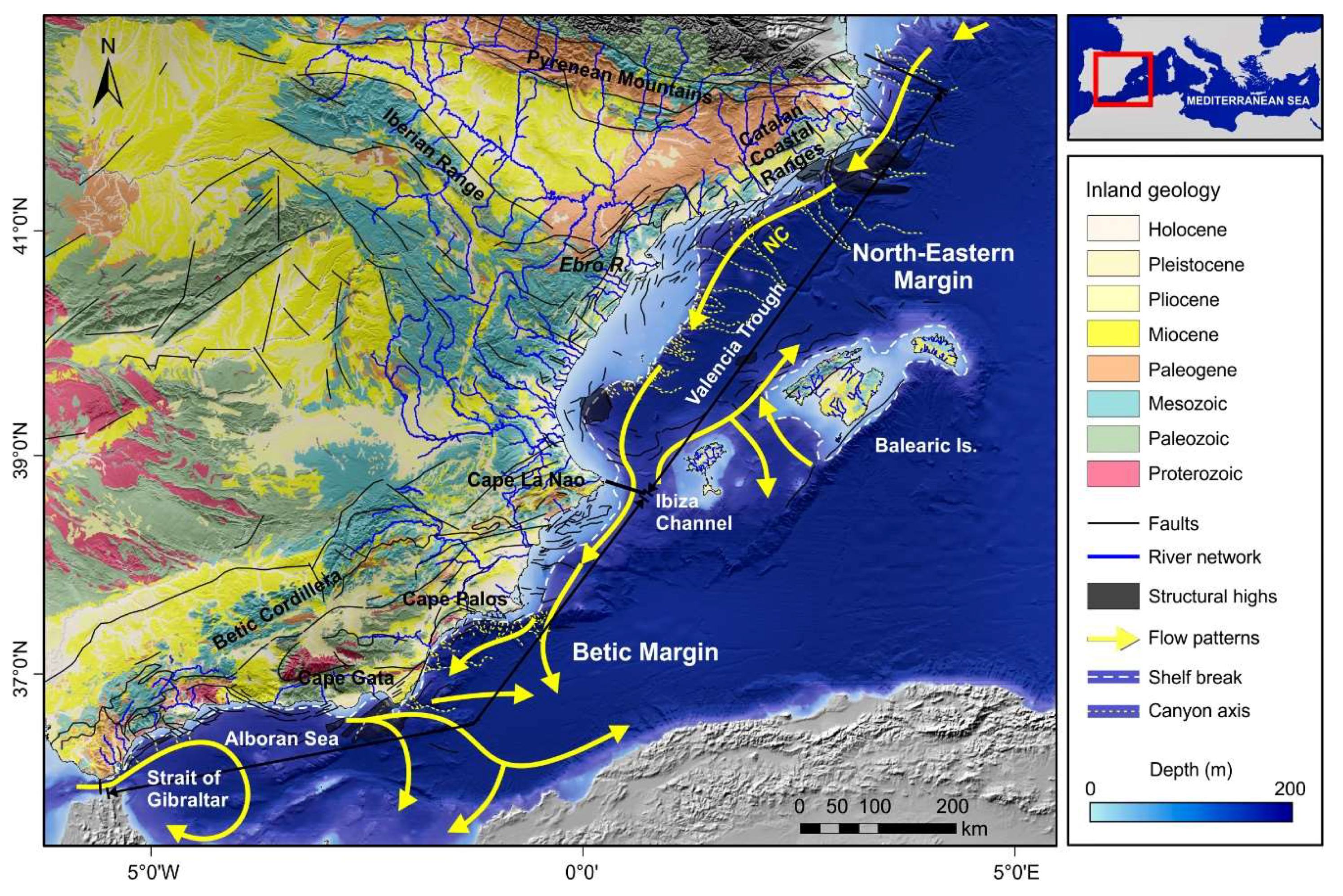
2.1. The North-Eastern Margin

The North-Eastern margin extends from the Pyrenean Mountains to Cape La Nao [20,21,22] (Figure 1). It constitutes the western boundary of the Valencia Trough, a NE-trending depression opened during the late Oligocene-early Miocene, during which horst and graben structures were formed. The post-rift evolution of the trough exhibited an attenuated tectonic activity and several episodes of extensional reactivation [23,24]. The western margin of the Valencia Trough shows a high morphological variability, with maximum shelf widths of more than 90 km off the Ebro River, whereas the shelf is very narrow (down to 0.6 km) in areas where it is indented by submarine canyons.
The Ebro River is the major sediment source (Figure 1). The rest of the margin is fed by medium-to-small rivers and streams draining either the Pyrenees (Muga, Fluvià, Ter) or the Catalan Coastal Ranges (Tordera, Besós, Llobregat), providing very variable suspended sediment concentrations [25]. South of the Ebro margin, the Gulf of Valencia is fed by medium rivers draining the Iberian Range and with low water discharges (Turia, Júcar).
Mesoscale circulation is characterized along the North-Eastern margin by a cyclonic current designed as the Northern Current (NC) carrying Modified Atlantic Water (MAW) [26]. The current flows southwestwards contouring the continental slope until exiting this region through the Ibiza Channel [27,28] (Figure 1). Lateral changes of the Catalan front that separates fresher waters influenced by continental inputs on the shelf from saltier waters basinward have been reported to occur on a seasonal basis [26].

2.2. The Betic Margin

The Betic margin extends from Cape La Nao in the eastern Iberian Peninsula to the Strait of Gibraltar in the Atlantic-Mediterranean boundary [20,21,22] (Figure 1). Its formation was initiated during the early Miocene by westward migration of the Betic mountain belt and coeval extension of its inner part, in a context of NW-SE convergence between the African and Eurasian plates [29,30,31]. Since the late Tortonian, the margin underwent a tectonic inversion, associated with a change of the relative Africa-Europe plate motion, which favored strike-slip and reverse faults, folds, and uplift of the basin margins [32,33,34]. The inland physiography of the Betic margin is dictated to a large extent by the nearby occurrence of the Betic Cordillera. The shelf width is highly variable, narrowing southwards. The shelf is wide in the Northern Arc between La Nao and Palos capes, with width values between 30 and 40 km [22]. In the Southern Arc between Palos and Gata capes and along the northern Alboran Sea, the shelf is very narrow and affected by several shelf-indenting canyons (Figure 1).
The southeastern part of the Iberian Peninsula is marked by an arid climate, with extreme temperatures and scarce rainfall. Consequently, even the major rivers (Segura, Almanzora) feeding the Northern and Southern arcs exhibit seasonal and highly irregular flow regimes. The northern margin of the Alboran Sea is fed by abundant short, steep river systems that exhibit a torrential character and marked seasonality and are very efficient in transporting sediments toward the marine realm [40,41]. The longest rivers from east to west are Andarax, Adra, Guadalfeo, Guadalhorce and Guadiaro.
The shallow-water circulation between La Nao and Gata capes is affected by the southwestward movement of the NC, that continues south of the Ibiza Channel, but with less energy and increasing mesoscale variability [26,28] (Figure 1). In contrast, the surface circulation in the Alboran Sea exhibits two anticyclonic gyres. Overall, the inflow of recent MAW at depths shallower than 200 m along the northern margin of the Alboran Sea is directed eastward and is separated by denser outflowing water masses by the Almeria-Oran front [26,28]. Shelf current patterns may be reversed according to variable wind conditions, attaining velocities of 0.1–0.15 m/s [42].

3. Materials and Methods

3.1. Characterization of Shelf Growth Patterns

To provide an overview of the regional variability of shelf growth patterns along the Iberian Mediterranean margin, we have used two types of data:
(a)
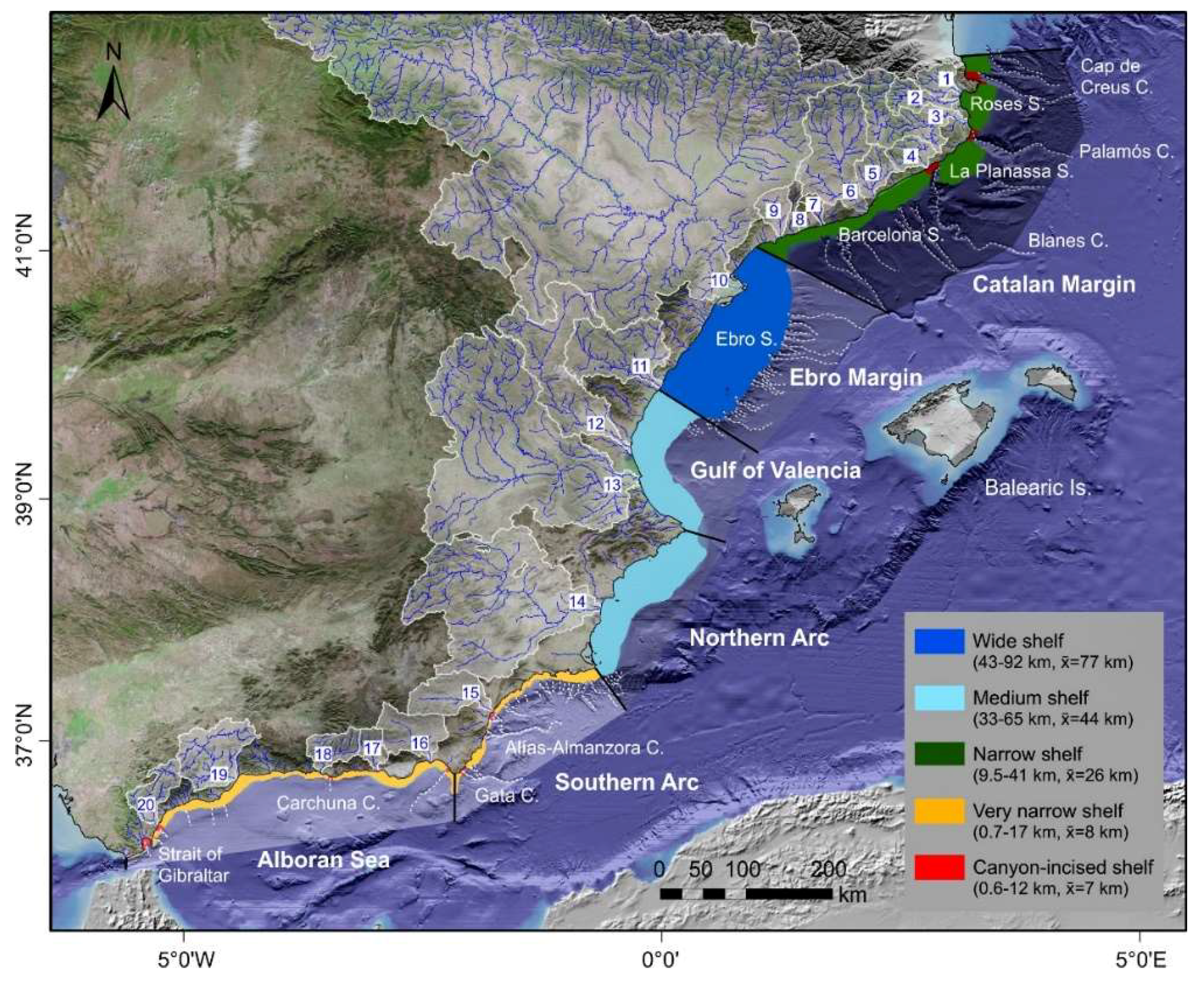
Bathymetric data covering the continental margins along the Mediterranean side of the Iberian Peninsula were extracted from the EMODNET portal (http://www.emodnet-bathymetry.eu) and from the Catalano-Balearic Sea bathymetric chart build from several oceanographic surveys [38] (Figure 1). From the bathymetric databases, 200 m resolution bathymetric grids have been generated. Based on these data, the shelf width, measured from the shoreline to the shelf edge, was calculated every 2 km along the Mediterranean continental margin using ArcGIS© Desktop v. 10.3 (ESRI, Redlands, CA, USA). Several physiographic sectors have been defined along the studied margin based on the shelf width: wide shelf, medium shelf, narrow shelf, very narrow shelf, and canyon-incised shelf.
(b)
Medium-to-high resolution seismic reflection data have been used to depict the upper Quaternary stratigraphic architecture (Table 1). We have mostly used published seismic data and interpretations, although in some cases we have interpreted unpublished seismic data collected from different sources. Seismic sections and interpretations have been selected to cover the regional variability exhibited by the margins, according to the morphological analysis.
The seismic interpretations relied in the application of conventional seismic stratigraphy analysis [44] to high-resolution seismic data [45] that led to the definition of unconformity-bounded seismic units. According to the seismic facies and external morphologies, the following main types of seismic units can be found along the Iberian Mediterranean margin: shelf regressive wedge (Figure 2a), shelf-margin regressive wedge (Figure 2b), high-angle shelf deposit, high-angle shelf-margin deposit (Figure 2c), sheet-like deposit, inner shelf wedge and valley infilling (Figure 2d). For each seismic section representative of a sector with distinctive morphological characteristics, the following parameters have been estimated: average thickness of sequences, progradation distance (relative to coastline) and shelf-edge trajectory. We assume that the bulk of the sequences are composed either by shelf or shelf-margin regressive wedges; therefore, we have focused on these types of units to determine the above-mentioned parameters.

3.2. Evaluation of Regional Controlling Factors

The possible influences of sediment supply variations and uplift-subsidence regime on seismic sequence development and longer-term stacking patterns have been assessed:
(a)
Sediment supply. We have compiled a wealth of information regarding hydrological information of the Mediterranean rivers, including hydrological and morphometric information of the river and watersheds. Morphometric information of rivers and watersheds has been derived from 200 m resolution Digital Elevation Models (DEM) provided by the Spanish National Geographic Institute (IGN). River watersheds and river courses were provided by the Spanish Ministry of Agriculture and Fisheries, Food and Environment (MAPAMA). Morphometric data include area and maximum elevation of the river basin, river maximum elevation, river length and slope.
Hydrological information was gathered from Catalan Water Agency (ACA), Ebro Hydrographic Confederation (SAIH Ebro), Júcar Hydrographic Confederation (CHJ), Segura Hydrographic Confederation (CHS), Andalusian Regional Ministry of Environment and Territorial Planning and Andalusian Basins Hydrologic Automatic Information System (SAIH Hidrosur). The hydrological data set consists of meteorological time series and daily water discharge data (Q in m3 s−1) derived from gauging stations located nearest to the outlet of each drainage basin. The length of the time series ranges from 3 to 50 years including temporary gaps of variable duration. From these data, mean and maximum water discharges were calculated. Data were completed with bibliographic data about historical major floods and sediment supply.
(b)
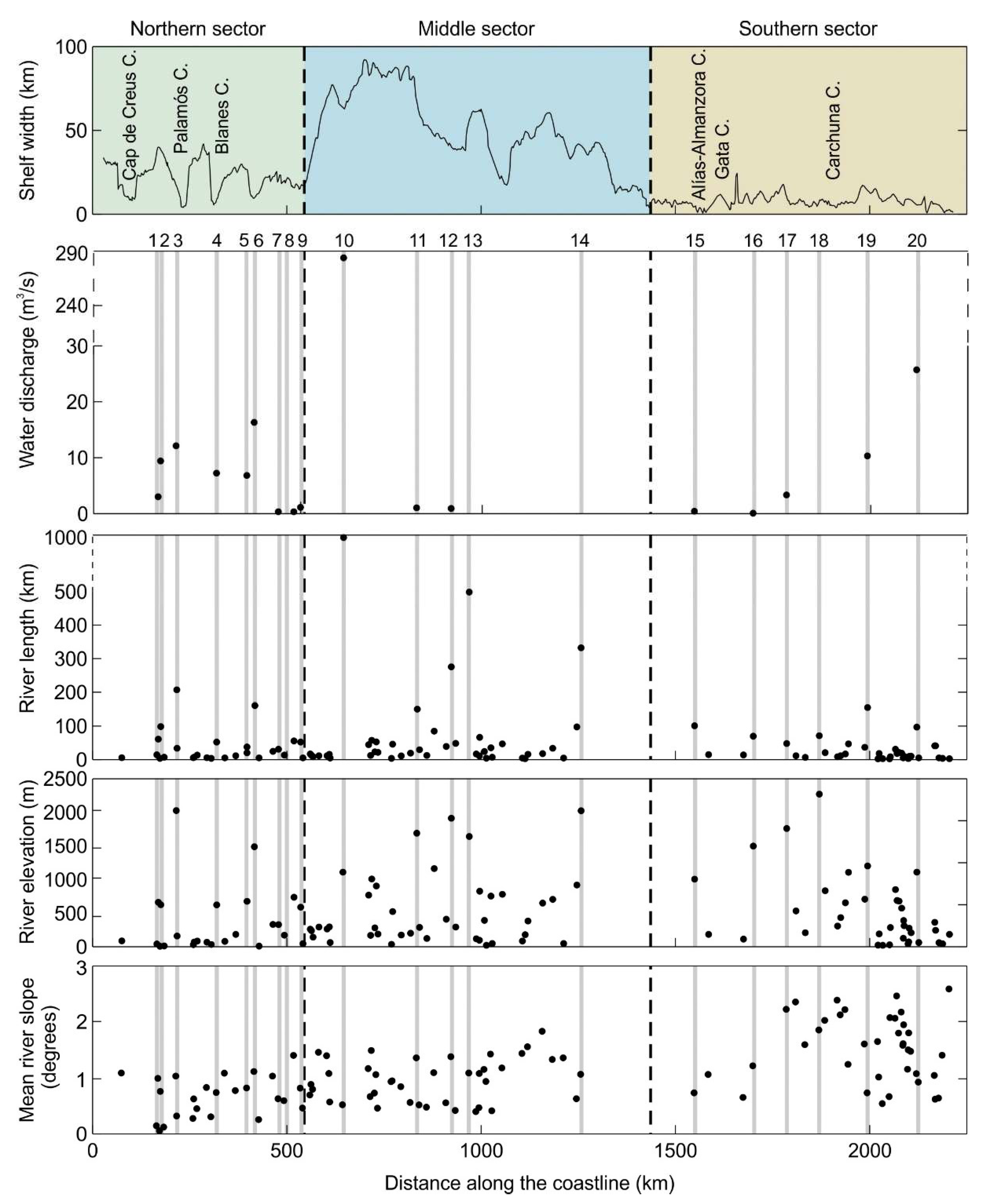
Uplift-subsidence regime. We have compiled uplift and/or subsidence values for the different sectors of the Iberian Mediterranean margins as reported in the literature. The margin has been divided into three main sectors: northern, middle, and southern. The northern sector comprises the northernmost shelf north of Blanes Canyon and the Barcelona Shelf. The middle sector comprises the Ebro Shelf, the Gulf of Valencia, and the Northern Arc. The southern sector comprises the Southern Arc and the northern Alboran Shelf.

4. Results

4.1. Morpho-Stratigraphy of the Iberian Mediterranean Shelves

4.1.1. Geomorphology

The extension of the shelves within the continental margin has enabled the definition of three distinct sectors with specific widths (Figure 3 and Figure 4):
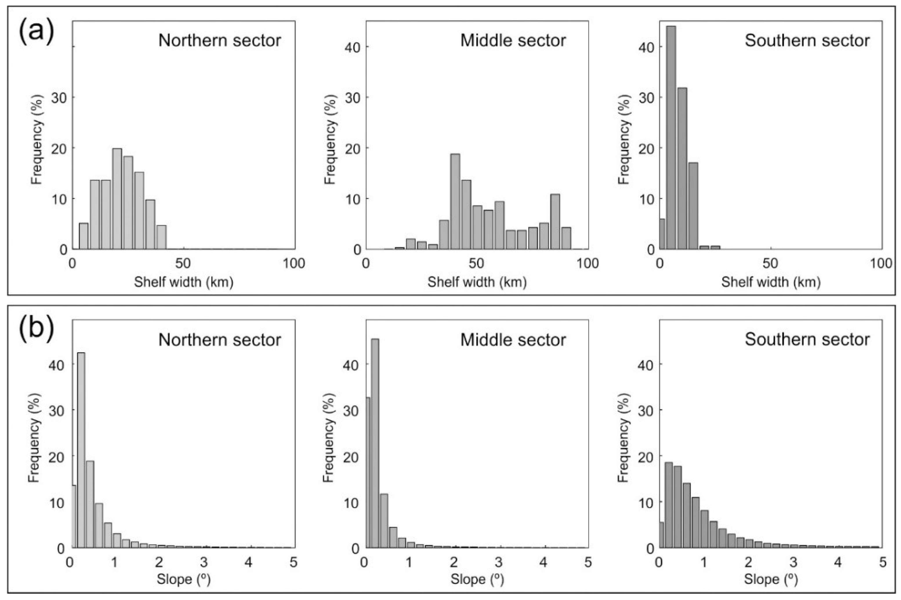
  • The northern sector comprises the continental shelf of the Catalan Margin. The width, measured normal to the isobaths, is highly variable. It ranges between 9.5 and 41 km averaging 26 km and being particularly narrow (9.5–13.4 km) off the Llobregat delta (Figure 3 and Figure 4a). The northernmost part is affected by several shelf-incising canyons, such as the Cap de Creus, Palamós and Blanes canyons, which divides the margin into three sectors: Roses, La Planassa and Barcelona shelves from north to south. The shelf is more extensive in the Roses (15 km on average, up to 40 km) and La Planassa (21 km on average, up to 35 km) sectors than in the Barcelona sector (13 km on average, up to 24 km). Only where submarine canyons incise the continental shelf, the shelf width is reduced to 0.6–2.6 km. The seafloor gradient displays high variability, with an average value of 0.45° (Figure 4b).
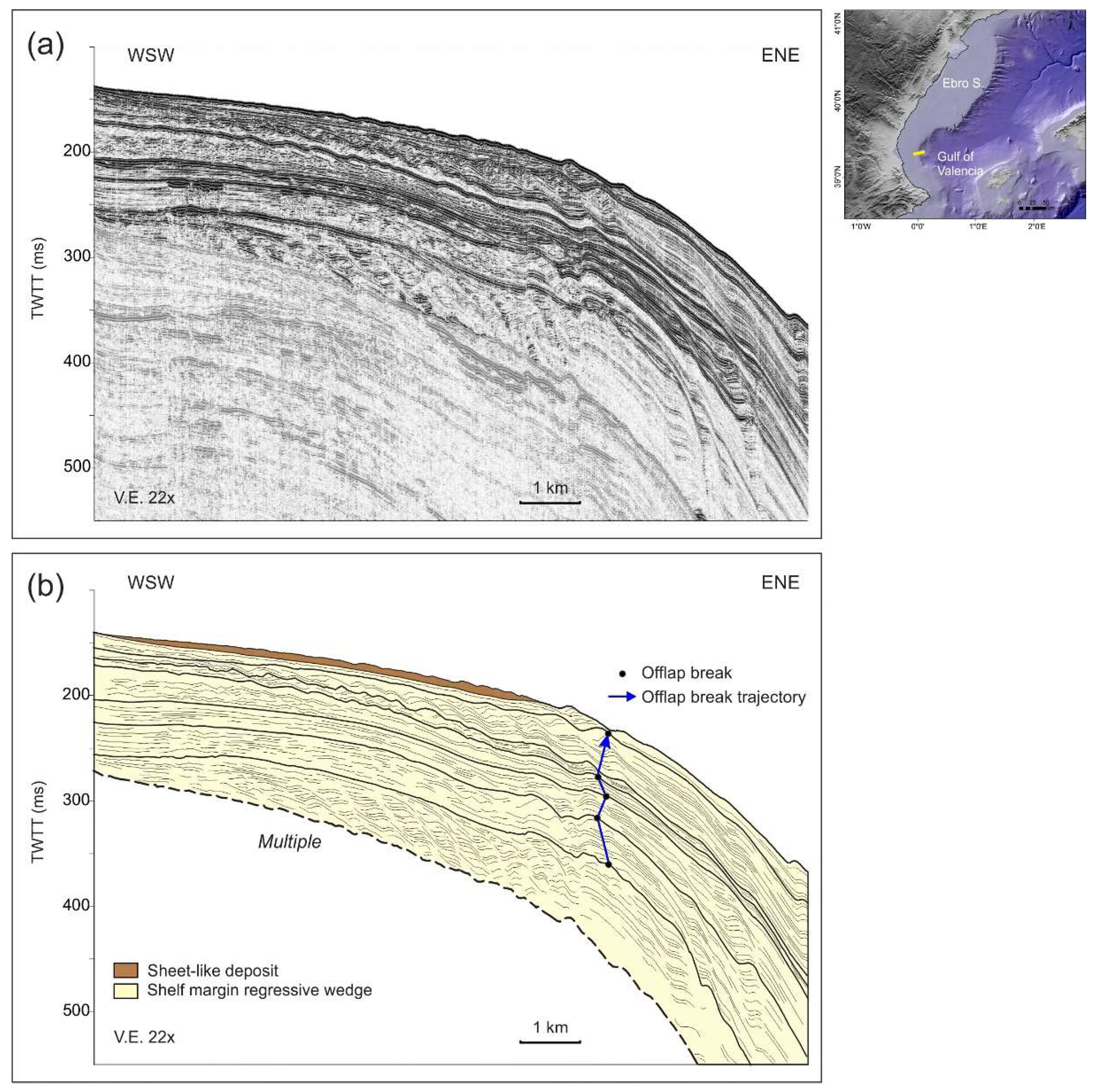
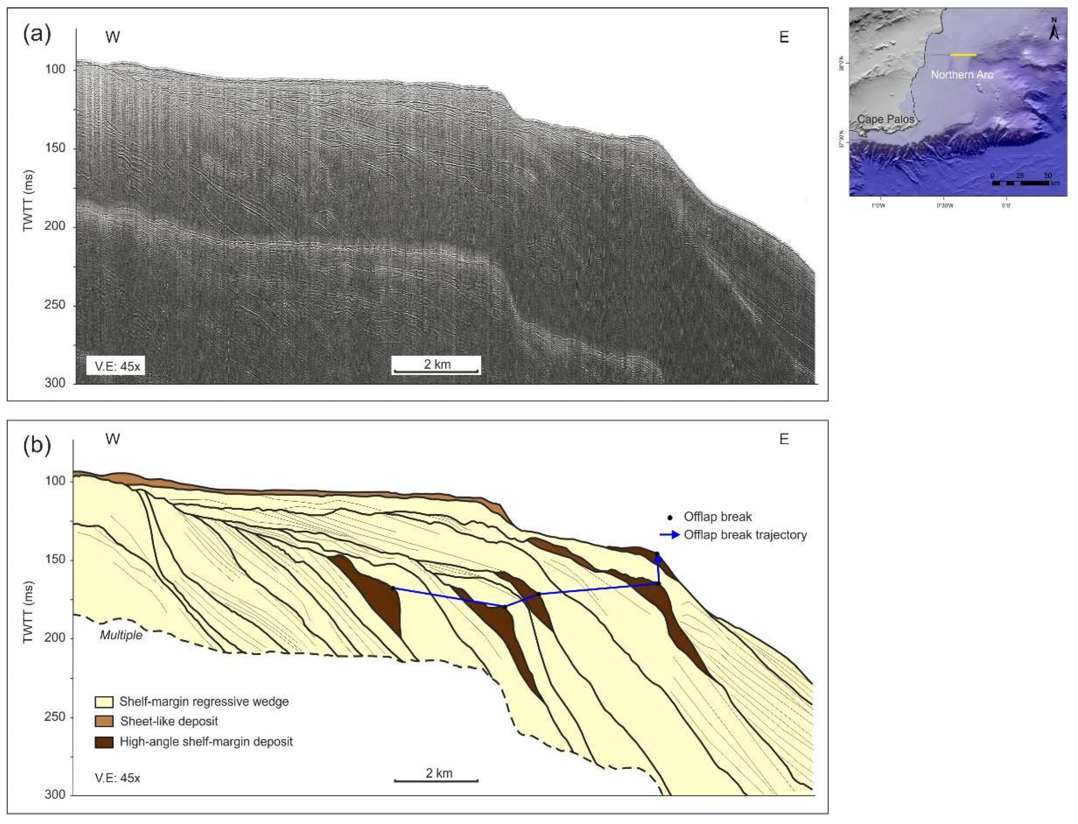
  • The middle sector comprises the Ebro Shelf, the Gulf of Valencia, and the Northern Arc. The Ebro Shelf width ranges between 43 and 92 km, with a mean width of 77 km (Figure 3 and Figure 4a). To the south, both the Gulf of Valencia and the Northern Arc contain moderately wide shelves, ranging between 33 and 65 km and averaging 44 km; the only exception is the narrower shelf off Cape La Nao (up to 33 km). The seafloor gradient is markedly homogeneous (0.25° on average), particularly in the Ebro Shelf (Figure 4b).
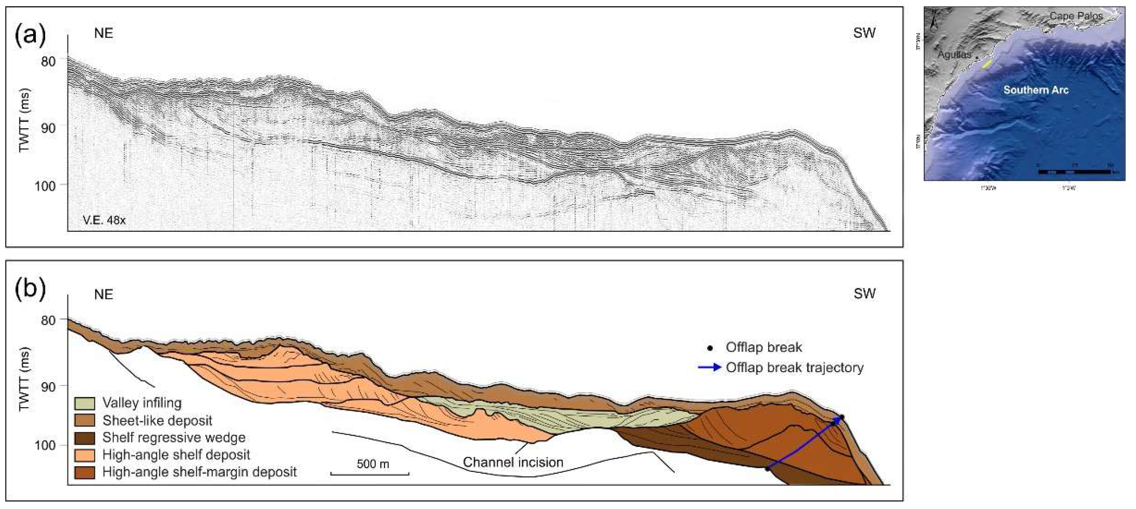
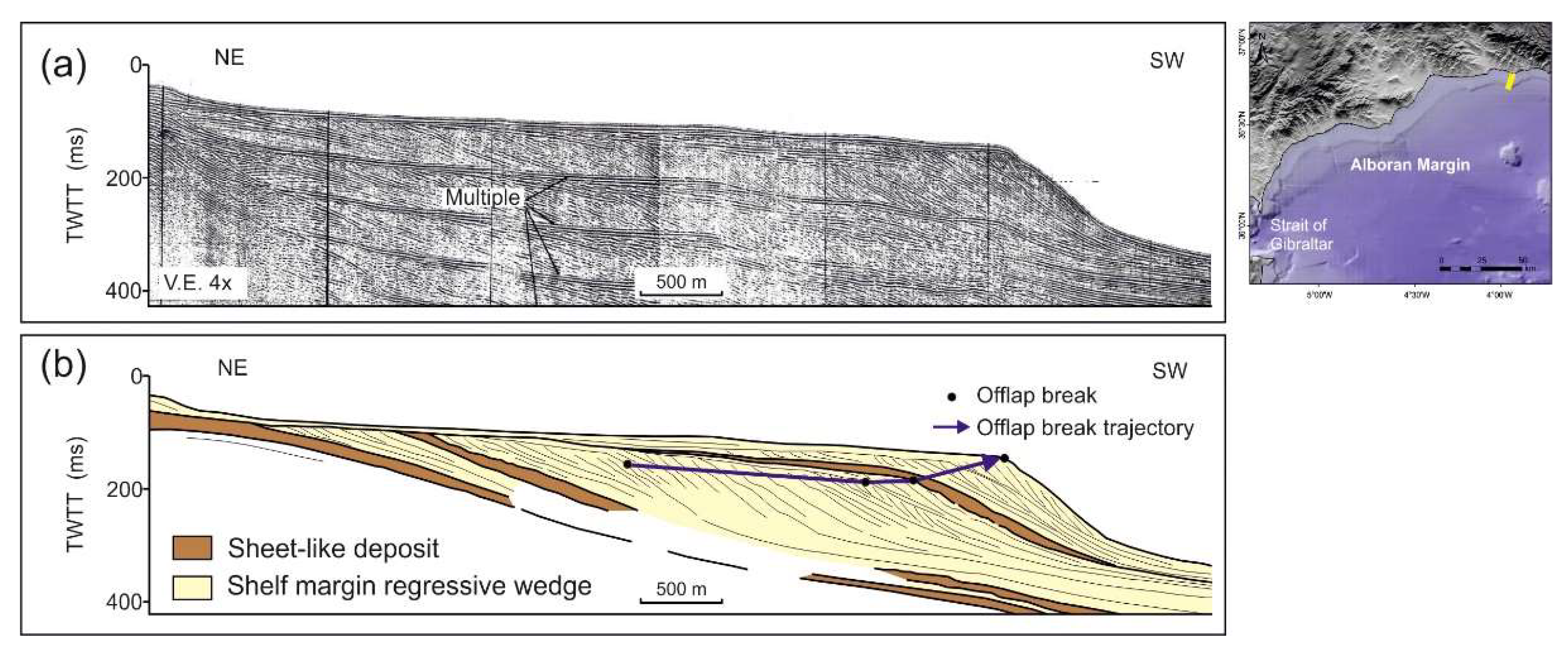
  • The southern sector comprises the Southern Arc and the northern shelf of the Alboran Sea (i.e., the northern Alboran Shelf). It is a very narrow margin locally dissected by submarine canyons. The width ranges between 0.7 km off coastal headlands and 17 km, with a mean width of 8 km (Figure 3 and Figure 4a). Only off Cape Gata the shelf is wider (up to 24 km). Canyon-incised shelves occur near the Strait of Gibraltar, around the capes Sacratif and Gata and in the middle part of the Southern Arc. The seafloor gradient is the highest of the margin with an average of 0.94° (Figure 4b).

4.1.2. Sediment Architecture of the Shelves

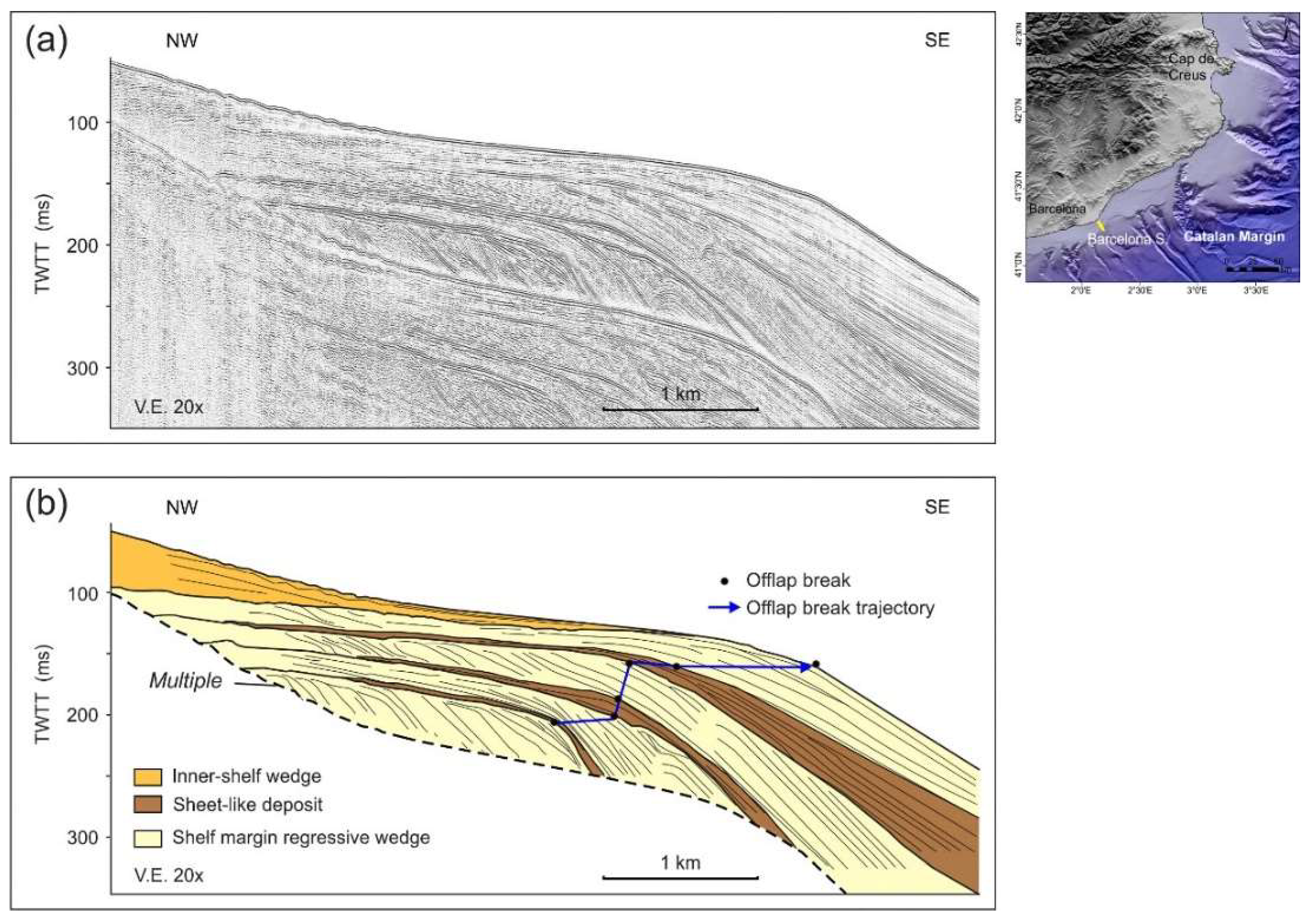
The Northern Shelf Sector

Two different stratigraphic schemes are presented: (a) seismic section and interpretation of the Roses Shelf, representative of the northernmost shelf located between shelf-indenting canyons; (b) seismic section and interpretation of the Barcelona Shelf. No detailed stratigraphic scheme of La Planassa Shelf is available.
In the Roses Shelf, the Pleistocene architecture is dominated by the vertical stacking of shelf-margin regressive wedges which compose up to seven depositional sequences (Figure 5, Table 2). Sheet-like deposition and inner shelf wedges are restricted to the last sequence. Indeed, recent depositional bodies are rare in these northernmost sectors and include non-protruding deltas [46]. Regressive wedges show relatively constant thickness on the shelf, up to 50 ms Two-Way Travel Time (TWTT) and led to progradation distances of 20–25 km (Table 2). The shelf-edge trajectory was initially flat and then changed to ascending (Figure 5).
In the Barcelona Shelf, at least four depositional sequences are identified (Table 2). The bulk of the sequences are also composed by shelf-margin regressive wedges, where they can be up to 50 ms TWTT thick landward of the previous shelf breaks. Several units are identified in the Barcelona Shelf intercalated between the widespread regressive wedges (Figure 6). These units are aggradational and with a relatively constant and moderate thickness (sheet-like). However, locally lenticular and/or wedge-like deposits occur [7,8]. The most recent depositional unit is composed by seaward decreasing thickness inner-shelf wedges. Progradation distances are moderate (5–7 km) in the Barcelona sector (Table 2). The shelf-edge trajectory is mostly flat, with a middle ascending interval (Figure 6). Significant depocenters with thickness higher than 50–60 ms TWTT are found seaward of underlying shelf breaks [7,8]. This sector is not affected by presently active canyons, although some buried canyons are locally found [7].

The Middle Shelf Sector

Representative seismic sections and interpretations are provided for the three shelf sectors: the Ebro Shelf, the Gulf of Valencia, and the Northern Arc.
In the Ebro Shelf, at least four depositional sequences can be distinguished. The sequences are primarily composed by shelf and shelf-margin regressive wedges, that extent over large distances with relatively constant thicknesses. Indeed, average thickness does not surpass 50 ms TWTT, but progradations distances are higher than 50 km (Figure 7, Table 2). The shelf-edge trajectory defined by the stacking of the regressive wedges is ascending. Seaward, stratified facies are interbedded with chaotic, wavy, or transparent facies, and interrupted by mass-transport deposits related to the Ebro turbidite system [47] or are locally bounded seaward by canyon heads [9]. Some inner shelf units consisting of basal parallel and upper progradational configurations with a dominant southward progradation appear intercalated between the extensive regressive wedges (Figure 7). The most significant recent deposit is the Ebro River prodelta, which laterally evolves into an extensive mud blanket [48]. Prodeltaic deposits mostly exhibit sigmoid-oblique clinoforms with a component of southward progradation.
In the Gulf of Valencia, the assumed upper Quaternary record exhibits seven depositional sequences that are mostly composed by shelf-margin regressive wedges representing shelf and shelf-margin deltas that exhibit average thickness up to 50 ms TWTT on the shelf (Figure 8, Table 2). These units are bounded by regional erosional unconformities and show internal subparallel to oblique-parallel reflections. Progradation distances generated by these shelf-margin wedges attain around 25 km (Table 2), and their stacking pattern generates a purely ascending shelf-edge trajectory (Figure 8). Several intercalated mounded units with oblique and irregular internal reflections delimit sub-horizontal reflections landward [49].
In the Northern Arc, the observed Quaternary record includes five depositional sequences mostly composed by shelf-margin regressive wedges that lead the margin outbuilt (Figure 9, Table 2). Over the different shelf breaks generated by the major regressive wedges, high-angle wedges are observed. A sheet-like deposit is only observed in the most recent depositional sequence. Sediment thickness of individual sequences on the shelf is variable between 25 and 50 ms TWTT. The progradation distance of the shelf ranges approximately between 23 and 27 km (Table 2), and the shelf-edge trajectory is mostly descending to flat, with a minor recent ascending interval (Figure 9).

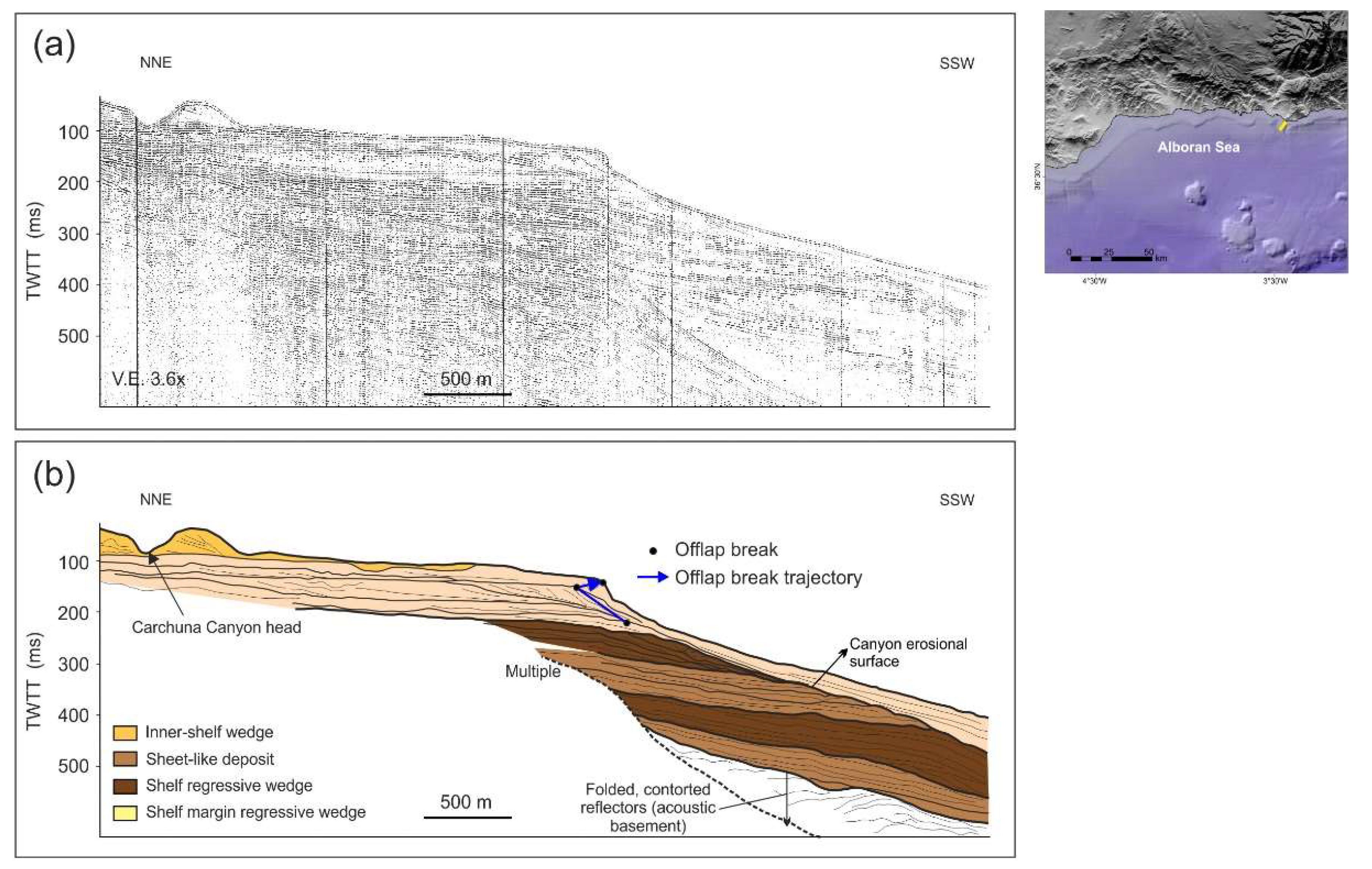
The Southern Shelf Sector

The upper Quaternary record shows considerable lateral variability along the southern margin. Representative seismic sections are provided for the Southern Arc and the northern Alboran Shelf. In addition, we also provide a seismic section and interpretation characteristic of a shelf-indenting canyon, which are conspicuous features along the southern shelves.
In the Southern Arc, the recent stratigraphy is reported in the shelf off Águilas [43], where it is mostly composed of several high-angle prograding shelf and shelf-margin clinoforms with wedge to mounded external shapes (Figure 10, Table 2). Proximally, high-angle shelf deposits are disposed in a backstepping pattern. On the distal part of the shelf, only distal leftovers of shelf regressive wedges are found, and most of the stratigraphy is composed by high-angle shelf-margin deposits. A valley infilling is recognized between the proximal and distal sections. Finally, the uppermost stratigraphy is composed by a sheet-like deposit with superimposed bedforms. Inner shelf wedges show moderate to low development off the main stream (i.e., the Almanzora River). Average thickness of the deposits is moderate, with maximum values of 10–15 ms TWTT. The progradation distance is also reduced, less than 10 km (Table 2). The observed shelf-edge trajectory is slightly ascending (Figure 10).
In the northern shelf of the Alboran Sea, the upper Quaternary record appears to be composed of several progradational shelf-margin wedges (two to three unconformity-bounded sequences can be determined depending on the location). Sheet-like deposits may be found intercalated between the regressive wedges (Figure 11). The most recent depositional event is recorded by inner shelf wedges off the main entry points [13,50], evolving into sigmoid-to-oblique in places of minor fluvial inputs [51,52]. The thickness of major regressive wedges can be 50 ms TWTT or slightly higher on the shelf, and they usually exhibit forestepping stacking patterns [13,53]; the progradation distances generated by such stacking patterns is usually moderate (i.e., few kilometers) (Figure 11, Table 2). Stacking patterns may change laterally such in the case of the shelf off the Guadafeo River, where deposits tend to stack vertically. Overall, the shelf-edge trajectory tends to be flat with some moderate ascending trend, although the outer shelf and upper slope are sediment-starved areas in specific locations [53].
Submarine canyons may indent the continental shelf and incise Quaternary deposits in several locations along the southern margin [53]. In the case of the Carchuna Canyon, the canyon erodes most of the shelf and shelf-margin units, causing an overall margin backstepping and a landward migrating shelf edge trajectory (Figure 12). Here, even an inner shelf wedge is eroded. The canyon is infilled by a single seismic unit with a variable thickness of 25 to 50 ms TWTT (Table 2).

4.2. Regional Controlling Factors

4.2.1. Sediment Supply

Geomorphologic and geologic characteristics of river basins and recent hydrological data are used to infer sediment supply conditions of the basins. With the exception of the Ebro River, the Spanish Mediterranean rivers show common characteristics, such as relatively small size, high seasonal variability, and relatively high slope due to the short distance between mountain headwaters and river mouths. However, the analysis of 20 medium to large rivers from Cap de Creus to Strait of Gibraltar (Figure 3) revealed morphological and hydrological differences along the margin (Table 3 and Table 4).
The northern sector continental shelves are fed by sediments from medium-to-small rivers and ephemeral streams that have their headwaters in the Pyrenees and the Catalan Coastal Ranges (Figure 3). From north to south the main rivers flowing into this margin are the Muga, Fluvià, Ter, Tordera, Besós, Llobregat, Foix, Gaia and Francolí. The Ter and Llobregat basins show the largest areas (2994 km2 and 4995 km2, respectively) and reach the highest altitude of the watersheds (2242 m and 1512 m, respectively), whereas the Foix and Gaia are the smallest ones (319 km2 and 429 km2, respectively). In general, the slope of the rivers is relatively high (0.7°–1.4°) due to the short distance between the mountain headwaters and the river mouths (Table 3, Figure 13). Mean water discharge is low, particularly in the southernmost watersheds (Foix and Gaia), where values are about 0.3 m3 s−1, but it is maximum in the Llobregat and Ter rivers (16.3 m3 s−1 and 12.1 m3 s−1 on average, respectively) (Table 3). Observed sediment discharge in the Catalan rivers is highly variable and ranges between 0.4 and 2000 mg L−1, with maximum sediment concentrations occurring in spring [25]. Between the monitored rivers, there are abundant ephemeral streams that are dried for most of the year but become particularly active during flood events. The ephemeral streams show variable lengths (2.5–36.47 km) and slopes (0.1–1.3°, 0.64° on average) (Figure 14).
The middle sector continental shelves are fed by the Ebro River and other medium rivers such as the Mijares, Turia, Júcar and Segura (Figure 3). The Ebro River is the largest river of the Mediterranean margin in terms of length (969 km) and drainage area (84,608 km2) (Figure 13, Table 3). Mean water discharge recorded in Tortosa, located 40 km upstream of the river mouth, for the period 1988–2018 is 238 m3 s−1, with peaks up to 2490 m3 s−1 (Table 4). Historical analysis of river flooding revealed several major floods since 1780 (e.g., 1787, 1863, 1871, 1866, 1887, 1907) [54], with the maximum peak flood (12,000 m3 s−1) recorded in 1907 [55]. During the last 30 years, the main suspended load transferred from the river to the sea was estimated at 99,500 ± 17,918 t/year [56]. The Mijares, Turia, Júcar and Segura rivers are smaller (less than 500 km) and are characterized by low water discharge (<1 m3 s−1 on average), with the exception of the Júcar River (12 m3 s−1 on average). Historical data recorded notable values for the Turia River during the catastrophic floods of the 28 September 1949 (2300 m3 s−1) and the 14 October 1957 (3700 m3 s−1) [57]. The Segura River recorded four exceptional floods in 1834, 1879, 1884, 1895, reaching maximum values of 938, 1890, 1425, 1230 m3 s−1 [54]. In addition to these rivers, several small rivers and ephemeral streams have been mapped with lengths varying from 1.7 to 47 km and mean slopes of 0.4–1.9° (0.9° on average) (Figure 14).
The major rivers draining the southern sector continental shelves from north to south are: Almanzora, Andarax, Ara, Guadalfeo, Guadalhorce and Guadiaro, with variable catchment areas and river lengths ranging from 746 to 3200 km2 and from 46 to 154 km, respectively (Figure 13, Table 3). Because of the short distance between the mountain headwaters and the shoreline, Andalusian rivers reach the maximum elevations (800–2335 m) and the highest mean axial gradients (0.7–2.2°) of the study rivers (Figure 13, Table 3). These rivers lack flowing water for much of the year, because of the semi-arid climate of the region, but extreme rainfalls cause catastrophic flash-flood events [58]. Mean water discharge of these rivers from 1997 to 2002 varies from 0.03 to 25.7 m3 year−1 but peaks up to 484–535 m3 year−1 were recorded in the Guadalhorce and Guadiaro rivers, respectively (Figure 13, Table 4). Historical analysis of river flooding periods of the Almanzora River revealed several major floods since 1550 [58,59]. Recently, the most catastrophic flood recorded in the Almanzora River occurred in October 1973 with a water discharge of 3500 m3 s−1 [58]. In terms of sediment transport, the Andalusian river systems are efficient independently of the small size of their catchments [40]. This behavior has been interpreted as a result of the ability of these rivers to respond to flash floods and the lack of areas within river basins to store flood-driven sediment [40]. In addition to these rivers, the southern sector is fed by sediment from active seasonal rivers and “ramblas” that usually carry a relatively large volume of water during the stormy season while they are dry during the rest of the year. A total of 33 ephemeral streams have been identified with lengths varying from 1.1 to 47 km and mean river slopes of 0.5–2.6° (1.6° on average), reflecting a strong torrential character (Figure 14).

4.2.2. Subsidence and Uplift

The northern margin is characterized by shelf tilting, with inshore uplift and offshore subsidence. Few estimations have been reported along this margin (Table 5) but indicate subsidence in the Gulf of Roses and along the Barcelona Shelf during the Plio-Quaternary.
The middle margin is mostly characterized by subsidence along most of the areas, both in the coast and offshore (Table 5). The Ebro Shelf is the main subsiding area that also affects the Gulf of Valencia. In contrast, tectonic uplift affects the Northern Arc, at least in the middle part.
The transition between the Northern and Southern arcs is characterized by tectonic subsidence, but most of the southern margin is affected by uplift and tilting of the margin (Table 5).

5. Discussion

Assuming a dominant control of 100 ka glacio-eustatic cycles on sequence generation, the influence of the sediment supply conditions and the uplift-subsidence trend are regarded as the main factors driving the observed shelf growth variability, determining the occurrence of well-defined sectors ranging from extensive to very narrow shelves (Figure 15).

5.1. Variability of Sediment Supply

The Iberian Mediterranean shelves exhibit contrasting physiographic and hydrologic patterns of the drainage basins that are marked to a large extent in their physiography and stratigraphic development, suggesting that the amount of fluvial supply is a major driving control in the shelf development.
The middle sector continental shelves appear to receive the higher sediment supplies, strongly conditioned by the Ebro River (Figure 3), with the largest drainage basin covering a large percentage of sedimentary rocks (Table 3) and with the higher water discharges of the Iberian Peninsula (Figure 13, Table 4). As a result, the Ebro Shelf displays the highest widths (tens of kilometers) of the entire margin and the lowest average slopes (Figure 4). Also, the most extensive upper Quaternary sequences, with progradation distances exceeding 50 km (Table 2), occur in the Ebro Shelf (Figure 7). Significant development of transgressive and/or highstand deposits predating the Last Glacial Maximum [9] would account for a continuous sediment supply irrespective of the sea-level position. South of the Ebro Shelf, the shelf progressively decreases towards the Northern Arc (Figure 13), although maintaining high width values (average value of 44 km) and relatively high progradation distances (average value of 25 km) (Table 2). Although both the Gulf of Valencia and Northern Arc are fed by relatively large rivers (i.e., several hundreds of km long) with extensive drainage basins (Figure 3, Table 3) mainly over sedimentary rocks, their discharges are very small (Figure 13, Table 4), as they are influenced by a semiarid regional climate. Therefore, we interpret that the significant shelf growth south of the Ebro Shelf in this middle stretch is mainly driven by southward advection by the NC of the Ebro-derived sediments. Therefore, the remaining sectors of the middle margin are also relatively well fed, despite the relatively low contributions of the fluvial entry points. The occurrence of indurate barriers in the Gulf of Valencia would also be indicative of a certain amount of sediment redistribution during transgressive/highstand conditions [49,66].
The northern and southern shelf sectors are narrower and steeper that the middle sector (Figure 4). In addition, the progradation distances are much lower, although shelf sequences may exhibit higher average thickness (Table 2). These evidences would indicate the influence of a lower and/or less efficient sediment supply in comparison to the middle shelves (Figure 15). However, they still show appreciable physiographic differences. In general terms, the northern shelves are wider and gentler than the southern shelves (Figure 4). This could indicate some distinctive patterns of sediment supply conditions. In fact, the southern shelves are fed by steeper and higher catchments than the northern shelves (Figure 14). Furthermore, the percentage of hard rock in the catchments is higher in the southern shelves (Table 3). We interpret that this difference would accentuate the flashy nature of the discharge in the southern shelves, leading to a more efficient sediment transport and therefore to a lower sediment retention on the shelf. Prodeltaic deposition is thought to have guided major advances of the shelf margin during successive regressive intervals in the northern Alboran Shelf [13,53]. Active sediment bypass and transfer towards deeper domains apparently takes place also during highstand conditions, as inferred by submarine undulations observed in highstand prodeltas [67,68]. Thus, the sediment transport towards the basin seems to be relatively independent of the sea-level position. Local conditions of very reduced fluvial supply could also be favorable for the preferential development of coarse-grained bodies in specific shelf sectors, such as prograding wedges [51] or sediment ridges in the Aguilas continental shelf in the Northern Arc [43].
In contrast, in the northern shelves the combination of abundant minor rivers (Table 3 and Table 4) affected by the southward NC in the Barcelona Shelf would lead to a rather homogeneous shelf growth, mainly driven by thick prodeltaic deposits with restricted spatial distribution and infralittoral prograding wedges. Both types of deposits constitute the bulk of regressive wedges, whereas transgressive deposition is limited to sand sheets and/or retreating barriers and ridges [46,69], indicating that sediment flux would have been continued, although diminished, during rising sea-level conditions [8]. North of the Barcelona Shelf, the occurrence of shelf-indenting canyons may promote specific sediment supply conditions. For example, the combined contribution of several rivers would lead to a significant shelf growth in the Roses Shelf.

5.2. Uplift-Subsidence and Margin Physiography

For the assessment of the influence of relative uplift-subsidence conditions in the margin, we use the observed shelf edge trajectory as this parameter can be used to estimate long-term relative sea-level trends [70]. Along the study area, inshore tectonic uplift linked to compressive structures in mountain chains and shelf tilting occur in several margins (Table 5): (a) off the Pyrenaic Axial Zone in the northernmost boundary of the Iberian margins [6]; (b) along the southern part of the northern margin (i.e., the Barcelona Shelf) [7,8,60]; (c) compressive active structures of the Betic Cordillera propagate seaward into the northern Arc [11]; (d) wide sectors of the southern margin are influenced by the structural compression of the Betic Cordillera and are subjected to tectonic tilting or folding [12,13,53]. Overall, it was found that these sectors are broadly characterized by flat shelf-edge trajectories (Table 2), indicating long-term stable or falling trends, favoring the sediment by pass toward deeper domains. The most significant examples are provided by the Northern Arc, where the seaward prolongation of Betic compressive structures led to even partially descending shelf-edge trajectories (Figure 9), and the Barcelona Shelf, where the margin tectonic tilting conditioning a flat shelf-edge trajectory most of the time (Figure 6). Along the southern margins, shelf edge trajectories were more loosely defined due to the poor representation of depositional sequences in comparison to other areas (Figure 10 and Figure 11).
In contrast, the main subsiding areas (Ebro Shelf and Gulf of Valencia) exhibit ascending shelf-edge trajectories with a strong vertical component (Table 2), indicative of long-term relative sea-level rises (Figure 7 and Figure 8). The most pronounced subsiding area is the Ebro Shelf in the middle margin [9] (Table 5), characterized by significant aggradation mainly due to high sediment load and compaction [14]. Subsidence is also significant in the Gulf of Valencia (Table 5), allowing the preservation of coastal barriers [49]. Other more restricted areas also show enhanced subsidence in relation to lateral sectors; for example, inter-canyon areas of the northern margin (i.e., the Roses Shelf) are mainly characterized by ascending shelf-edge trajectories (Figure 5), signaling the influence of tectonic subsidence on the long-term growth pattern.
Submarine canyons constitute an important control in delimiting the growth of the margins in specific sectors of the Iberian Mediterranean margins. In the northernmost part of the margin, several canyons eroded regressive deposits and prevented the margin advance [6]. There, the location of canyons is mainly dictated by the existence of several basement-controlled platforms inherited from the Messinian period [71]. Along the southern margin, shelf-indenting canyons also produced erosional downcutting of the margins at several locations of the northern Alboran Sea [53,72] and the Southern Arc [73]. In terms of shelf-edge trajectory, those processes are mainly reflected by the occurrence of landward migrating trajectories (Figure 12). Most of these features also originated in the Messinian Salinity Crisis and are very effective in transporting sediments toward deeper domains since a direct connection with fluvial sources is established in many cases. There are other areas (i.e., Ebro margin) where submarine canyons are restricted to the slope domain [14,17] and their influence in controlling shelf dimensions is less relevant.

5.3. Types of Iberian Mediterranean Shelves: Definition of End-Members

The amount of sediment supply combined with the tectono-physiographic setting may be used to establish different end-member margin scenarios, as documented for the Italian shelves [74,75]. Overall, the Iberian Mediterranean shelves can be regarded as sediment-fed, as they are mainly influenced by fluvial supplies of different significances. However, long-term building styles enable the distinguishing of a well-defined shelf gradation as a result of the combination of different conditions of sediment supply and uplift-subsidence regime: wide shelf (middle sector), narrow shelf (northern sector), and very narrow shelf (southern sector) (Figure 15).
  • Wide shelf. The wide extension of the middle sector shelves results from the lateral gradation of the balance between sediment supply and the uplift-subsidence rate (Figure 15), as the N-S sediment transport trend is compensated by a change of the tectonic regime. The high Ebro River sediment supply and subsiding setting in the north evolves to a partial southward sediment redistribution that affects the still subsiding Gulf of Valencia. Southward, the seaward prolongation of the Betic structures and the dominant uplifting trend has enabled the lateral growth of the Northern Arc, even under conditions of reduced sediment supply (Figure 15).
  • Narrow shelf. The northern sector shelf exhibits moderate development, due to the combination of low sediment supply by several medium to small rivers (e.g., Llobregat, Besós and Tordera rivers) that would have acted as a linear source and the margin tectonic tilting with a low subsiding shelf (Figure 15). This pattern would be more pronounced south of the Besós River, as sediments tend to be advected southwestward forming submarine prodeltas, whereas prograding wedges tend to develop in areas with shortage of sediments such as around the Blanes Canyon [7]. The occurrence of submarine canyons in the northernmost part of this sector establishes a compartmentalization of the margin where dominant processes may vary as a function of local conditions of supply and/or erosion, as well as the subsidence pattern. For example, the Gulf of Roses is a main depositional area, as it receives the combined supply of seasonal rivers such as the Fluviá, Mugá and Ter and has been affected by tectonic subsidence. In contrast, La Planassa Shelf is dominated by erosional features, attesting for a very reduced sediment supply and sediment depletion [69].
  • Very narrow shelf. The southern sector shelves exhibit the poorest development of the entire Iberian Mediterranean margin (Figure 15), due to a very effective sediment transport toward the basin [40], driven by two main factors. The type of sediment input is markedly torrential, with numerous but seasonal minor rivers (e.g., Guadalhorce, Guadalfeo, Adra) and creeks that produce violent, flash floods. In addition, the prevailing uplifting along the Betic Cordillera led to the occurrence of abrupt margins that together with frequent submarine canyons would lead to the generation of such undersupplied margins, as hyperpycnal flows and littoral dynamics could be captured by canyons [52,73] and contribute to submarine fan formation [72].

6. Conclusions

The morpho-sedimentary variability exhibited by the Iberian Mediterranean shelves may be explained as the balance between the sediment supply, the tectonic setting expressed by the uplift-subsidence relationship and the occurrence of submarine canyons deeply incising the shelf. As a result, three end-member shelf types are defined.
The middle shelves are the widest, because of lateral changes of the sediment supply and the uplift-subsidence pattern. The widest Ebro Shelf is mainly influenced by the highest sediment supplies derived from the Ebro River, a subsidence regime and the southwestward sediment redistribution governed by south-flowing geostrophic flows and a change to tectonic uplift in the south.
The northern shelves are narrower, developed on a tilted margin by the influence of a linear source mostly maintained by the combined input of several minor rivers. This trend is interrupted in the northernmost area, where several canyons deeply incising the continental shelf establish a compartmentalization of the margin.
The southern shelves are very narrow because of a very effective sediment transfer toward deeper domains, conditioned by the uplift of the Betic Cordillera driving very steep catchments and torrential fluvial regimes.

Author Contributions

R.D. and F.J.L. wrote the initial draft of the text and delineated most of the figures. M.R., M.G. and L.S. provided specific inputs, as they assisted in the writing and delineated several figures.

Funding

This research was funded by the Spanish Ministry of Economy, Industry and Competitiveness projects CGL2011-30302-C02-02, CGL2015-74216-JIN, CTM2015-65142-R and CTM2017-88237-P.

Acknowledgments

The authors would like to thank G. Ercilla, M. Farrrán, C. Liquete and H. Perea for providing high-resolution seismic data of the study areas. Seismic data were imported into IHS Kingdom Suite software for interpretation. Three external reviewers provided abundant and useful comments that led to a significant rewriting and refocus of the original contribution.

Conflicts of Interest

The authors declare no conflict of interest.

References

  1. Pratson, L.F.; Nittrouer, C.A.; Wiberg, P.L.; Steckler, M.S.; Swenson, J.B.; Cacchione, D.A.; Karson, J.A.; Murray, A.B.; Wolinsky, M.A.; Gerber, T.P.; et al. Seascape Evolution on Clastic Continental Shelves and Slopes. In Continental Margin Sedimentation: From Sediment Transport to Sequence Stratigraphy; Nittrouer, C.A., Austin, J.A., Field, M.E., Kravitz, J.H., Syvitski, J.P.M., Wiberg, P.L., Eds.; Blackwell Publishing Ltd.: Hoboken, NJ, USA, 2007; Volume 37, pp. 339–380. ISBN 9781444304398. [Google Scholar]
  2. Mountain, G.S.; Burger, R.L.; Delius, H.; Fulthorpe, C.S.; Austin, J.A.; Goldberg, D.S.; Steckler, M.S.; McHugh, C.M.; Miller, K.G.; Monteverde, D.H.; et al. The Long-Term Stratigraphic Record on Continental Margins. In Continental Margin Sedimentation: From Sediment Transport to Sequence Stratigraphy; Nittrouer, C.A., Austin, J.A., Field, M.E., Kravitz, J.H., Syvitski, J.P.M., Wiberg, P.L., Eds.; Blackwell Publishing Ltd.: Hoboken, NJ, USA, 2007; Volume 37, pp. 381–458. ISBN 9781444304398. [Google Scholar]
  3. Chiocci, F.L.; Ercilla, G.; Torres, J. Stratal architecture of Western Mediterranean Margins as the result of the stacking of Quaternary lowstand deposits below ‘glacio-eustatic fluctuation base-level’. Sediment. Geol. 1997, 112, 195–217. [Google Scholar] [CrossRef]
  4. Bassetti, M.A.; Berné, S.; Jouet, G.; Taviani, M.; Dennielou, B.; Flores, J.A.; Gaillot, A.; Gelfort, R.; Lafuerza, S.; Sultan, N. The 100-ka and rapid sea level changes recorded by prograding shelf sand bodies in the Gulf of Lions (western Mediterranean Sea). Geochem. Geophys. Geosyst. 2008, 9. [Google Scholar] [CrossRef]
  5. Ridente, D.; Trincardi, F.; Piva, A.; Asioli, A. The combined effect of sea level and supply during Milankovitch cyclicity: Evidence from shallow-marine δ18O records and sequence architecture (Adriatic margin). Geology 2009, 37, 1003–1006. [Google Scholar] [CrossRef]
  6. Ercilla, G.; Farrán, M.; Alonso, B.; Díaz, J.I. Pleistocene progradational growth pattern of the Northern Catalonia continental shelf (Northwestern Mediterranean). Geo-Mar. Lett. 1994, 14, 264–271. [Google Scholar] [CrossRef]
  7. Liquete, C.; Canals, M.; De Mol, B.; De Batist, M.; Trincardi, F. Quaternary stratal architecture of the Barcelona prodeltaic continental shelf (NW Mediterranean). Mar. Geol. 2008, 250, 234–250. [Google Scholar] [CrossRef]
  8. Gámez, D.; Simó, J.A.; Lobo, F.J.; Barnolas, A.; Carrera, J.; Vázquez-Suñé, E. Onshore-offshore correlation of the Llobregat deltaic system, Spain: Development of deltaic geometries under different relative sea-level and growth fault influences. Sediment. Geol. 2009, 217, 65–84. [Google Scholar] [CrossRef]
  9. Farrán, M.; Maldonado, A. The Ebro continental shelf: Quaternary seismic stratigraphy and growth patterns. Mar. Geol. 1990, 95, 289–312. [Google Scholar] [CrossRef]
  10. Ribó, M.; Puig, P.; Urgeles, R.; Van Rooij, D.; Muñoz, A. Spatio-temporal evolution of sediment waves developed on the Gulf of Valencia margin (NW Mediterranean) during the Plio-Quaternary. Mar. Geol. 2016, 378, 276–291. [Google Scholar] [CrossRef]
  11. Perea, H.; Gràcia, E.; Alfaro, P.; Bartolomé, R.; Lo Iacono, C.; Moreno, X.; Masana, E.; Team, E.-S. Quaternary active tectonic structures in the offshore Bajo Segura basin (SE Iberian Peninsula—Mediterranean Sea). Nat. Hazard Earth Syst. 2012, 12, 3151–3168. [Google Scholar] [CrossRef] [Green Version]
  12. Hernández-Molina, F.J.; Somoza, L.; Vázquez, J.T.; Lobo, F.; Fernández-Puga, M.C.; Llave, E.; Díaz-del-Río, V. Quaternary stratigraphic stacking patterns on the continental shelves of the southern Iberian Peninsula: Their relationship with global climate and palaeoceanographic changes. Quat. Int. 2002, 92, 5–23. [Google Scholar] [CrossRef]
  13. Lobo, F.J.; Maldonado, A.; Hernández-Molina, F.J.; Fernández-Salas, L.M.; Ercilla, G.; Alonso, B. Growth patterns of a proximal terrigenous margin offshore the Guadalfeo River, northern Alboran Sea (SW Mediterranean Sea): Glacio-eustatic control and disturbing tectonic factors. Mar. Geophys. Res. 2008, 29, 195–216. [Google Scholar] [CrossRef]
  14. Kertznus, V.; Kneller, B. Clinoform quantification for assessing the effects of external forcing on continental margin development. Basin Res. 2009, 21, 738–758. [Google Scholar] [CrossRef]
  15. Lofi, J.; Rabineau, M.; Gorini, C.; Berne, S.; Clauzon, G.; De Clarens, P.; Tadeu Dos Reis, A.; Mountain, G.S.; Ryan, W.B.F.; Steckler, M.S.; et al. Plio-Quaternary prograding clinoform wedges of the western Gulf of Lion continental margin (NW Mediterranean) after the Messinian Salinity Crisis. Mar. Geol. 2003, 198, 289–317. [Google Scholar] [CrossRef]
  16. Harris, P.T.; Whiteway, T. Global distribution of large submarine canyons: Geomorphic differences between active and passive continental margins. Mar. Geol. 2011, 285, 69–86. [Google Scholar] [CrossRef]
  17. Mauffrey, M.-A.; Urgeles, R.; Berné, S.; Canning, J. Development of submarine canyons after the Mid-Pleistocene Transition on the Ebro margin, NW Mediterranean: The role of fluvial connections. Quat. Sci. Rev. 2017, 158, 77–93. [Google Scholar] [CrossRef]
  18. Anthony, E.J.; Marriner, N.; Morhange, C. Human influence and the changing geomorphology of Mediterranean deltas and coasts over the last 6000 years: From progradation to destruction phase? Earth Sci. Rev. 2014, 139, 336–361. [Google Scholar] [CrossRef]
  19. Martín-Vide, J. Spatial distribution of a daily precipitation concentration index in peninsular Spain. Int. J. Climatol. 2004, 24, 959–971. [Google Scholar] [CrossRef]
  20. Lobo, F.J.; Ercilla, G.; Fernández-Salas, L.M.; Gámez, D. Chapter 11 The Iberian Mediterranean shelves. In Continental Shelves of the World: Their Evolution During the Last Glacio-Eustatic Cycle; Chiocci, F.L., Chivas, A.R., Eds.; Geological Society: London, UK, 2014; Volume 41, pp. 147–170. ISBN 0435-4052. [Google Scholar]
  21. Lobo, F.J.; Durán, R.; Roque, C.; Ribó, M.; Carrara, G.; Mendes, I.; Ferrín, A.; Fernández-Salas, L.M.; García-Gil, S.; Galparsoro, I.; et al. Shelves around the Iberian Peninsula (II): Evolutionary sedimentary patterns. Bol. Geol. Min. 2015, 126, 377–408. [Google Scholar]
  22. Fernández-Salas, L.M.; Durán, R.; Mendes, I.; Galparsoro, I.; Lobo, F.J.; Bárcenas, P.; Rosa, F.; Ribó, M.; García-Gil, S.; Ferrín, A.; et al. Shelves of the Iberian Peninsula and the Balearic Islands (I): Morphology and sediment types. Bol. Geol. Min. 2015, 126, 327–376. [Google Scholar]
  23. Maillard, A.; Mauffret, A. Crustal structure and riftogenesis of the Valencia Trough (north-western Mediterranean Sea). Basin Res. 1999, 11, 357–379. [Google Scholar] [CrossRef]
  24. Roca, E.; Guimerà, J. The Neogene structure of the eastern Iberian margin: Structural constraints on the crustal evolution of the Valencia trough (western Mediterranean). Tectonophysics 1992, 203, 203–218. [Google Scholar] [CrossRef]
  25. Liquete, C.; Canals, M.; Ludwig, W.; Arnau, P. Sediment discharge of the rivers of Catalonia, NE Spain, and the influence of human impacts. J. Hydrol. 2009, 366, 76–88. [Google Scholar] [CrossRef]
  26. Sayol, J.M.; Orfila, A.; Simarro, G.; López, C.; Renault, L.; Galán, A.; Conti, D. Sea surface transport in the Western Mediterranean Sea: A Lagrangian perspective. J. Geophys. Res.-Oceans 2013, 118, 6371–6384. [Google Scholar] [CrossRef]
  27. Font, J.; Miralles, L. Circulación geostrófica en el Mar Catalán. Res. Exp. Cient. B/O Cornide 1978, 7, 155–162. [Google Scholar]
  28. Millot, C. Circulation in the Western Mediterranean Sea. J. Mar. Syst. 1999, 20, 423–442. [Google Scholar] [CrossRef]
  29. Comas, M.C.; Platt, J.P.; Soto, J.I.; Watts, A.B. The origin and tectonic history of the Alboran Basin: Insights from leg 161 results. In Proceedings of the Ocean Drilling Program, Scientific Results; Zahn, R., Comas, M.C., Klaus, A., Eds.; Ocean Drilling Program: College Station, TX, USA, 1999; Volume 161, pp. 555–580. [Google Scholar]
  30. Acosta, J.; Fontán, A.; Muñoz, A.; Muñoz-Martín, A.; Rivera, J.; Uchupi, E. The morpho-tectonic setting of the Southeast margin of Iberia and the adjacent oceanic Algero-Balearic Basin. Mar. Pet. Geol. 2013, 45, 17–41. [Google Scholar] [CrossRef]
  31. Do Couto, D.; Gorini, C.; Jolivet, L.; Lebret, N.; Augier, R.; Gumiaux, C.; d’Acremont, E.; Ammar, A.; Jabour, H.; Auxietre, J.-L. Tectonic and stratigraphic evolution of the Western Alboran Sea Basin in the last 25 Myrs. Tectonophysics 2016, 677–678, 280–311. [Google Scholar] [CrossRef]
  32. Ballesteros, M.; Rivera, J.; Muñoz, A.; Muñoz-Martín, A.; Acosta, J.; Carbó, A.; Uchupi, E. Alboran Basin, southern Spain—Part II: Neogene tectonic implications for the orogenic float model. Mar. Pet. Geol. 2008, 25, 75–101. [Google Scholar] [CrossRef] [Green Version]
  33. Muñoz, A.; Ballesteros, M.; Montoya, I.; Rivera, J.; Acosta, J.; Uchupi, E. Alborán Basin, southern Spain–Part I: Geomorphology. Mar. Pet. Geol. 2008, 25, 59–73. [Google Scholar] [CrossRef]
  34. Gómez de la Peña, L.; Gràcia, E.; Muñoz, A.; Acosta, J.; Gómez-Ballesteros, M.; Ranero, C.R.; Uchupi, E. Geomorphology and Neogene tectonic evolution of the Palomares continental margin (Western Mediterranean). Tectonophysics 2016, 689, 25–39. [Google Scholar] [CrossRef]
  35. Catafau, E.; Gaytán, M.; Pereda, I.; Vázquez, J.T.; Wandosell, J. Mapa Geológico de la Plataforma Continental Española y Zonas Adyacentes. Escala 1:200.000. Hojas 72-73 (Elche-Alicante); Instituto Geológico y Minero de España: Madrid, Spain, 1994. [Google Scholar]
  36. Catafau, E.; Díaz, J.I.; Medialdea, T.; San Gil, C.; Vázquez, J.T.; Wandosell, J. Mapa Geológico de la Plataforma Continental Española y Zonas Adyacentes. Escala 1:200.000. Hojas 79-79E (Murcia); Instituto Geológico y Minero de España: Madrid, Spain, 1994. [Google Scholar]
  37. Comas, M.C.; García-Dueñas, V.; Jurado, M.J. Neogene tectonic evolution of the Alboran Sea from MCS data. Geo-Mar. Lett. 1992, 12, 157–164. [Google Scholar] [CrossRef]
  38. Farrán, M. Catalano-Balearic Sea (NW Mediterranean): Bathymetric chart and toponyms. Available online: http://gma.icm.csic.es/sites/default/files/geowebs/MCB/CBSbats_cat.htm (accessed on 27 April 2018).
  39. López-García, M.J.; Millot, C.; Font, J.; García-Ladona, E. Surface circulation variability in the Balearic Basin. J. Geophys. Res. 1994, 99, 3285–3296. [Google Scholar] [CrossRef]
  40. Liquete, C.; Arnau, P.; Canals, M.; Colas, S. Mediterranean river systems of Andalusia, southern Spain, and associated deltas: A source to sink approach. Mar. Geol. 2005, 222–223, 471–495. [Google Scholar] [CrossRef]
  41. Bárcenas, P.; Lobo, F.J.; Macías, J.; Fernández-Salas, L.M.; López-González, N.; Díaz del Río, V. Submarine deltaic geometries linked to steep, mountainous drainage basins in the northern shelf of the Alboran Sea: Filling the gaps in the spectrum of deltaic deposition. Geomorphology 2015, 232, 125–144. [Google Scholar] [CrossRef]
  42. Bárcenas, P.; Lobo, F.J.; Macías, J.; Fernández-Salas, L.M.; Díaz del Río, V. Spatial variability of surficial sediments on the northern shelf of the Alboran Sea: The effects of hydrodynamic forcing and supply of sediment by rivers. J. Iber. Geol. 2011, 37, 195–214. [Google Scholar] [CrossRef]
  43. Durán, R.; Guillén, J.; Rivera, J.; Lobo, F.J.; Muñoz, A.; Fernández-Salas, L.M.; Acosta, J. Formation, evolution and present-day activity of offshore sand ridges on a narrow, tideless continental shelf with limited sediment supply. Mar. Geol. 2017, 397, 93–107. [Google Scholar] [CrossRef]
  44. Mitchum, R.M.J.; Vail, P.R.; Sangree, J.B. Seismic Stratigraphy and Global Changes of Sea Level, Part 6: Stratigraphic Interpretation of Seismic Reflection Patterns in Depositional Sequences. In Seismic Stratigraphy-Applications to Hydrocarbon Exploration (AAPG Memoir 26); Payton, C.E., Ed.; American Association of Petroleum Geologists: Tulsa, OK, USA, 1977; pp. 117–133. [Google Scholar]
  45. Zecchin, M.; Catuneanu, O. High-resolution sequence stratigraphy of clastic shelves I: Units and bounding surfaces. Mar. Pet. Geol. 2013, 39, 1–25. [Google Scholar] [CrossRef]
  46. Durán, R.; Canals, M.; Lastras, G.; Micallef, A.; Amblas, D.; Pedrosa-Pàmies, R.; Sanz, J.L. Sediment dynamics and post-glacial evolution of the continental shelf around the Blanes submarine canyon head (NW Mediterranean). Prog. Oceanogr. 2013, 118, 28–46. [Google Scholar] [CrossRef]
  47. Escutia, C.; Maldonado, A. Palaeogeographic implications of the Messinian surface in the Valencia trough, northwestern Mediterranean Sea. Tectonophysics 1992, 203, 263–284. [Google Scholar] [CrossRef]
  48. Díaz, J.I.; Palanques, A.; Nelson, C.H.; Guillén, J. Morpho-structure and sedimentology of the Holocene Ebro prodelta mud belt (Northwestern Mediterranean Sea). Cont. Shelf Res. 1996, 16, 435–456. [Google Scholar] [CrossRef]
  49. Albarracín, S.; Alcántara-Carrió, J.; Barranco, A.; Sánchez García, M.; Fontán Bouzas, Á.; Rey Salgado, J. Seismic evidence for the preservation of several stacked Pleistocene coastal barrier/lagoon systems on the Gulf of Valencia continental shelf (western Mediterranean). Geo-Mar. Lett. 2013, 33, 217–223. [Google Scholar] [CrossRef]
  50. Ercilla, G.; Alonso, B.; Baraza, J. Post-Calabrian sequence stratigraphy of the northwestern Alboran Sea (southwestern Mediterranean). Mar. Geol. 1994, 120, 249–265. [Google Scholar] [CrossRef]
  51. Fernández-Salas, L.M.; Dabrio, C.J.; Goy, J.L.; Díaz del Río, V.; Zazo, C.; Lobo, F.J.; Sanz, J.L.; Lario, J. Land-sea correlation between Late Holocene coastal and infralittoral deposits in the SE Iberian Peninsula (Western Mediterranean). Geomorphology 2009, 104, 4–11. [Google Scholar] [CrossRef] [Green Version]
  52. Ortega-Sánchez, M.; Lobo, F.J.; López-Ruiz, A.; Losada, M.A.; Fernández-Salas, L.M. The influence of shelf-indenting canyons and infralittoral prograding wedges on coastal morphology: The Carchuna system in Southern Spain. Mar. Geol. 2014, 347, 107–122. [Google Scholar] [CrossRef]
  53. Ercilla, G.; Alonso, B.; Baraza, J. Sedimentary evolution of the Northwestern Alboran Sea during the Quaternary. Geo-Mar. Lett. 1992, 12, 144–149. [Google Scholar] [CrossRef]
  54. CEDEX. Mapa de Caudales Máximos; Technical Report; Ministerio de Medio Ambiente y Medio Rural y Marino: Madrid, Spain, 2011; 73p. [Google Scholar]
  55. Novoa, M. Precipitaciones y avenidas extraordinarias en Catalunya. In Ponencias y Comunicaciones de las Jornadas de Trabajo sobre Inestabilidad de laderas en el Pirineo; CSIC: Barcelona, Spain, 1984; Volume 1, pp. 1–15. [Google Scholar]
  56. Rovira, A.; Ibáñez, C.; Martín-Vide, J.P. Suspended sediment load at the lowermost Ebro River (Catalonia, Spain). Quat. Int. 2015, 388, 188–198. [Google Scholar] [CrossRef] [Green Version]
  57. Mateu, J.F. Crecidas e inundaciones en el País Valenciano. In Guía de la Naturaleza de la Comunidad Valenciana; Generalitat Valenciana: Valencia, Spain, 1988; pp. 595–654. [Google Scholar]
  58. Capel-Molina, J.J. Inundaciones y avenidas de los ríos de Almería: Una constante secular. Bol. Inst. Estud. Almer. 1987, 7, 25–42. [Google Scholar]
  59. Sánchez García, C.; Schulte, L.; Peña, J.C.; Carvalho, F.; Brembilla, C. A 500-year history of floods in the semi arid basins of south-eastern Spain. Geophys. Res. Abstr. 2016, 18, EGU2016-8255. [Google Scholar]
  60. Perea, H.; Masana, E.; Santanach, P. An active zone characterized by slow normal faults, the northwestern margin of the València trough (NE Iberia): A review. J. Iber. Geol. 2012, 38. [Google Scholar] [CrossRef]
  61. Fernández, F.; Bohoyo, F.; Maestro, A.; García-Mayordomo, J. Nuevas Aportaciones Sobre las Características Geométricas del Sistema de Fallas Amposta Oriental-Montsià Norte (Margen Catalano-Valenciano, España); 2ª Reunión Ibérica sobre Fallas Activas y Paleosismología: Lorca, Spain, 2014; pp. 105–108. [Google Scholar]
  62. Somoza, L.; Barnolas, A.; Arasa, A.; Maestro, A.; Rees, J.G.; Hernandez-Molina, F.J. Architectural stacking patterns of the Ebro delta controlled by Holocene high-frequency eustatic fluctuations, delta-lobe switching and subsidence processes. Sediment. Geol. 1998, 117, 11–32. [Google Scholar]
  63. Zazo, C.; Goy, J.L.; Dabrio, C.J.; Bardaji, T.; Somoza, L.; Silva, P.G. The last interglacial in the Mediterranean as a model for the present interglacial. Glob. Planet. Chang. 1993, 7, 109–117. [Google Scholar] [Green Version]
  64. Bardají, T.; Silva, P.G.; Lario, J.; Zazo, C.; Goy, J.L.; Dabrio, C.J.; Cabero, A. Quaternary coastal uplift: Betic littoral. In The Geology of Iberia: A Geodynamic Approach; Regional Geology Reviews Series; Quesada, C., Oliveira, J.T., Eds.; Springer: Berlin, Germany, in press.
  65. Bardají, T.; Cabero, A.; Lario, J.; Zazo, C.; Silva, P.G.; Goy, J.L.; Dabrio, C.J. Coseismic vs. climatic factors in the record of relative sea level changes: An example from the Last Interglacials in SE Spain. Quat. Sci. Rev. 2015, 113, 60–77. [Google Scholar] [CrossRef]
  66. Alcántara-Carrió, J.; Albarracín, S.; Montoya Montes, I.; Flor-Blanco, G.; Fontán Bouzas, Á.; Rey Salgado, J. An indurated Pleistocene coastal barrier on the inner shelf of the Gulf of Valencia (western Mediterranean): Evidence for a prolonged relative sea-level stillstand. Geo-Mar. Lett. 2013, 33, 209–216. [Google Scholar] [CrossRef]
  67. Lobo, F.J.; Fernández-Salas, L.M.; Moreno, I.; Sanz, J.L.; Maldonado, A. The sea-floor morphology of a Mediterranean shelf fed by small rivers, northern Alboran Sea margin. Cont. Shelf Res. 2006, 26, 2607–2628. [Google Scholar] [CrossRef]
  68. Fernández-Salas, L.M.; Lobo, F.J.; Sanz, J.L.; Díaz-del-Río, V.; García, M.C.; Moreno, I. Morphometric analysis and genetic implications of pro-deltaic sea-floor undulations in the northern Alboran Sea margin, western Mediterranean Basin. Mar. Geol. 2007, 243, 31–56. [Google Scholar] [CrossRef]
  69. Durán, R.; Canals, M.; Sanz, J.L.; Lastras, G.; Amblas, D.; Micallef, A. Morphology and sediment dynamics of the northern Catalan continental shelf, northwestern Mediterranean Sea. Geomorphology 2014, 204, 1–20. [Google Scholar] [CrossRef]
  70. Helland-Hansen, W.; Hampson, G.J. Trajectory analysis: Concepts and applications. Basin Res. 2009, 21, 454–483. [Google Scholar] [CrossRef]
  71. García, M.; Maillard, A.; Aslanian, D.; Rabineau, M.; Alonso, B.; Gorini, C.; Estrada, F. The Catalan margin during the Messinian Salinity Crisis: Physiography, morphology and sedimentary record. Mar. Geol. 2011, 284, 158–174. [Google Scholar] [CrossRef] [Green Version]
  72. Vázquez, J.T.; Ercilla, G.; Alonso, B.; Juan, C.; Rueda, J.L.; Palomino, D.; Fernández-Salas, L.M.; Bárcenas, P.; Casas, D.; Díaz-del-Río, V.; et al. Submarine canyons and related features in the Alboran Sea: Continental margins and major isolated reliefs. In Submarine Canyon Dynamics in the Mediterranean and Tributary Seas; Briand, F., Ed.; CIESM: Sorrento, Italy, 2015; Volume 47, pp. 183–196. [Google Scholar]
  73. Puig, P.; Durán, R.; Muñoz, A.; Elvira, E.; Guillén, J. Submarine canyon-head morphologies and inferred sediment transport processes in the Alías-Almanzora canyon system (SW Mediterranean): On the role of the sediment supply. Mar. Geol. 2017, 393, 21–34. [Google Scholar] [CrossRef]
  74. Martorelli, E.; Falese, F.; Chiocci, F.L. Chapter 12 Overview of the variability of Late Quaternary continental shelf deposits of the Italian peninsula. In Continental Shelves of the World: Their Evolution During the Last Glacio-Eustatic Cycle; Chiocci, F.L., Chivas, A.R., Eds.; Geological Society: London, UK, 2014; Volume 41, pp. 171–186. ISBN 0435-4052. [Google Scholar]
  75. Sulli, A.; Agate, M.; Mancuso, M.; Pepe, F.; Pennino, V.; Polizzi, S.; Lo Presti, V.; Gargano, F.; Interbartolo, F. Variability of depositional setting along the North-western Sicily continental shelf (Italy) during Late Quaternary: Effects of sea level changes and tectonic evolution. Alp. Mediterr. Quat. 2012, 25, 141–156. [Google Scholar]
Figure 1. Shaded-relief map of the Mediterranean margin of the Iberian Peninsula showing inland geology and the gross bathymetry of the continental margin. The offshore structure was synthesized from previous works [23,35,36,37]. The inshore structure and lithology were adapted from the One Geology Project (http://www.onegeology.org/). The topographic data were provided by the Spanish National Geographic Institute (www.ign.es). The bathymetric data were extracted from the EMODnet portal (http://portal.emodnet-bathymetry.eu/) and the Catalano-Balearic Sea bathymetric chart [38]. Sea surface circulation patterns were compiled from several studies [28,39]. NC: Northern Current.
Geosciences 08 00168 g001
Figure 2. Types of seismic units identified along the Mediterranean margin of the Iberian Peninsula: (a) shelf regressive wedge; (b) shelf-margin regressive wedge; (c) high-angle deposits; (d) valley infilling, sheet-like deposit, and inner-shelf wedge.
Geosciences 08 00168 g002
Figure 3. Shaded-relief map of the Mediterranean margin of the Iberian Peninsula including continental shelves and their specific widths. x ¯ : mean width of each sector. The northern sector comprises the Catalan Shelf. The middle sector includes the Ebro Shelf, the Gulf of Valencia, and the North Arc. The southern sector comprises the Southern Arc and the northern Alboran Shelf. Numbers correspond to the studied rivers: Muga (1), Fluvià (2), Ter (3), Tordera (4), Besós (5), Llobregat (6), Foix (7), Gaià (8), Francolí (9), Ebro (10), Mijares (11), Turia (12), Júcar (13), Segura (14), Almanzora (15), Andarax (16), Adra (17), Guadalfeo (18), Guadalhorce (19) and Guadiaro (20). The topographic data and the orthophoto were provided by the Spanish National Geographic Institute (www.ign.es). The bathymetric data were extracted from the EMODnet portal (http://portal.emodnet-bathymetry.eu/) and the Catalano-Balearic Sea bathymetric chart [38].
Geosciences 08 00168 g003
Figure 4. Frequency distribution of main geomorphological parameters of the continental shelf measured every 2 km along the Mediterranean continental margin: (a) shelf width and (b) slope.
Geosciences 08 00168 g004
Figure 5. (a) Uninterpreted and (b) interpreted high-resolution Uniboom seismic reflection profile of the Roses Shelf. Most of the shelf stratigraphic record is composed by shelf-margin regressive wedges, except the postglacial record, with identification of transgressive (sheet-like deposit) and highstand (inner-shelf wedge) features. The shelf-edge trajectory evolved from flat to ascending, suggesting a change of the tectonic regime. Modified from [6].
Geosciences 08 00168 g005
Figure 6. (a) Uninterpreted and (b) interpreted high-resolution Sparker seismic reflection profile of the Barcelona Shelf. This sector is characterized by the alternation of shelf-margin regressive wedges and sheet-like deposits. The shelf-edge trajectory is essentially flat. Modified from [7].
Geosciences 08 00168 g006
Figure 7. (a) Uninterpreted and (b) interpreted high-resolution Airgun seismic reflection profile of the Ebro Shelf. The shelf-edge trajectory is ascending. Modified from [9].
Geosciences 08 00168 g007
Figure 8. (a) Uninterpreted and (b) interpreted high-resolution Sparker seismic reflection profile of the shelf of the Gulf of Valencia. The upper Quaternary record is mainly composed of shelf-margin regressive wedges, with limited postglacial deposits. The shelf-edge trajectory was ascending (indeed, vertical). Modified from [10].
Geosciences 08 00168 g008
Figure 9. (a) Uninterpreted and (b) interpreted high-resolution Sparker seismic reflection profile of the shelf of the Northern Arc. The Quaternary record shows a strong development of shelf-margin regressive wedges with intercalated high-angle shelf-margin wedges, which constitutes a peculiarity along the Iberian Mediterranean margin. The shelf-edge trajectory displays a dominant flat trend. Modified from [11].
Geosciences 08 00168 g009
Figure 10. (a) Uninterpreted and (b) interpreted high-resolution TOPAS (parametric) seismic reflection profile of the shelf of the Southern Arc, characterized by the abundance of high-angle progradational units that are mostly confined to the shelf but some of them extending toward the shelf margin. The shelf-edge trajectory shows a minor ascending component. Modified from [43].
Geosciences 08 00168 g010
Figure 11. (a) Uninterpreted and (b) interpreted high-resolution Sparker seismic reflection profile of the northern Alboran Shelf. The stratigraphic architecture is dominated by shelf-margin regressive wedges, with several intercalated sheet-like deposits. The shelf-edge trajectory is essentially flat. Modified from [12].
Geosciences 08 00168 g011
Figure 12. (a) Uninterpreted and (b) interpreted high-resolution Sparker seismic reflection profile of the northern Alboran Shelf incised by the Carchuna Canyon. Most of the units are distally truncated by erosion at the canyon, which also affects the most recent inner shelf wedges. The shelf-edge trajectory is landward migrating. Modified from [13].
Geosciences 08 00168 g012
Figure 13. Along-margin variations of the shelf width and the main hydrologic (water discharge) and morphologic (river length, maximum elevation, and mean river slope) characteristics of the study rivers, as well as of the ephemeral streams identified along the margin. See Figure 3 for location.
Geosciences 08 00168 g013
Figure 14. River profiles of each sector of the Iberian Mediterranean shelves. Note the increasing slope of the studied rivers in the southern shelves. See Figure 3 for location.
Geosciences 08 00168 g014
Figure 15. Summary of shelf stratigraphic architectures identified along the Iberian Mediterranean margin, under variable conditions of sediment supply and uplift-subsidence relationship.
Geosciences 08 00168 g015
Table 1. Summary of acquisition and processing parameters used in the different seismic data presented in this study.
Shelf SectorData OriginAcquisition (Seismic Source)Processing
Roses[6]Uniboom (GeoPulse)Unspecified
Barcelona[7]300 J SparkerOffset correction, bandpass filtering, automatic gain control (AGC)
Ebro[9]AirgunUnspecified
Gulf of Valencia[10]SparkerBandpass filtering, water noise removal, burst noise removal, amplitude correction, trace editing
Northern Arc[11]6 kJ SparkerBandpass filtering, amplitude correction, swell filter
Southern Arc[43]TOPAS PS18 profilerBandpass filtering, time variant gain
Northern Alboran[12]3 kJ SparkerUnspecified
Shelf-indented canyon[13]1–4.5 kJ SparkerBandpass filtering, amplitude correction
Table 2. Quantification of main stratigraphic parameters deduced from the representative seismic sections and corresponding interpretations.
Shelf SectorNumber of SequencesAverage Thickness of Sequences (TWTT)Progradation DistanceShelf-Edge Trajectory
RosesSeven25 ms on the shelf19–25 kmFlat (minor)–Ascending (major)
BarcelonaAt least fourup to 50 ms on the shelf5.36–7.11 kmFlat-ascending-flat
EbroAt least fourup to 50 ms on the shelf53–58 kmAscending
Gulf of ValenciaSeven25 ms on the shelf26 kmAscending
Northern ArcFive25–50 ms on the shelf23.7–29.7 kmDescending to flat (major)–Ascending (minor)
Southern ArcOne10–15 ms8.5–9 kmAscending (minor)
Northern AlboranTwo–three50 ms on the shelf4–6.5 kmFlat (major)–Ascending (minor)
Shelf-indented canyonOne (canyon infilling)25–50 ms (canyon infilling)Not applicable (Erosion)Landward migrating
Table 3. Geomorphologic and geologic characteristics of the studied rivers.
SectorCodeRiverBasin Area (km2)Basin Max. Elevation (m)Hard Rocks (%)C. Sed. Rocks 1 (%)Recent Alluvial (%)River Max. Elevation (m)River Length (km)River Slope (°) 2
Northern sector1Muga7861432414911374591/0.25
2Fluvià994153828810716970.7/0.3
3Ter2994288232591022422061/0.3
4Tordera89216846816171223510.7/0.3
5Besós10371370175924819520.8/0.4
6Llobregat49952528391615121601.1/0.6
7Foix31998206337623300.7/0.5
8Gaià42998007327645671.4/0.8
9Francolí8541180125830732510.8/0.5
Middle sector10Ebro84,6083373977148739690.8/0.6
11Mijares40911990685913471492/1.3
12Turia17562016389915172742.5/0.6
13Júcar36,28018403801713074972.1/0.6
14Segura14,64220635752016143311.8/0.3
Southern sector15Almanzora22192156612415800991.1/0.7
16Andarax216425526419181193681.8/0.5
17Adra7462753841241869463/1.1
18Guadalfeo13023443663232335702.4/1.6
19Guadalhorce3200181417701310791541.2/0.5
20Guadiaro14721758138251061961.9/0.7
1 Consolidated sedimentary rocks; 2 Mean river slope/Low-course (0–100 m) river slope.
Table 4. Hydrological characteristics of the studied rivers. Modified and updated from [25].
SectorCodeRiverGauging StationData PeriodMean Q (m3 s−1)Max. Q (m3 s−1)Date of Max. Q
Northern sector1MugaCastelló d’Empuries1972–2002395017/02/82
2008–20180.93428/01/17
2FluviàGarrigas1971–20019.4120028/09/92
3TerPont de la Barca1985–200212.182004/12/87
2008–201810.232322/11/11
4TorderaFogars de Tordera 11992–20027.2183625/07/99
2008–20182.613314/01/15
5BesósSta. Coloma de Gramenet1968–20026.827009/05/91
2008–20183.97224/03/17
6LlobregatSant Joan Despi1968–200216.3160008/11/82
2008–201811.636101/12/14
7FoixCastellet i la Gornal1968–20020.324418/09/74
2008–20180.43510/10/10
8GaiàVilabella1975–20020.316701/09/84
2008–20180.24402/11/15
9FrancolíTarragona1974–20021.1102710/10/94
2008–2018142.711/04/09
Middle sector10EbroTortosa1988–2018267.8249024/10/00
11MijaresBabor1991–201615.801/09/97
12TuriaAcq. de Mestalla1992–20160.94.225/06/00
13JúcarCullera1915–199712.2140315/11/97
14SeguraRojales2007–20091.02123.329/12/11
Southern sector15AlmanzoraSanta Bárbara1963–20180.416006/11/72
16AndaraxTerque1997–20180.0310.724/12/09
17AdraDarrical1997–20181.39.905/03/10
18GuadalfeoÓrgiva2015–201819.107/03/18
19GuadalhorceCártama1997–201810.871115/02/05
20GuadiaroPablo Buceite1997–201812.248418/12/97
1 Fogars de la Selva (Can Simó) since 1995.
Table 5. Compilation of subsidence (−)/uplift (+) values documented along the Iberian Mediterranean margin, either inshore, at the coast or offshore.
Shelf SectorStudy AreaSubsidence-UpliftRates (mm year−1)Time IntervalReference
NorthernRoses: Pyrenean Axial ZoneUpliftNot provided [6]
Roses: Gulf of RosesSubsidence−0.03–0.07 (offshore)Plio-Quat.[60]
BarcelonaShelf tilting−0.02–0.11 (coast)Plio-Quat.[60]
MiddleEbroSedimentary and tectonic subsidence−0.03–0.09 (inshore), −0.01–0.10 (offshore)Plio-Quat.[60]
EbroSedimentary and tectonic subsidence−0.16–0.26 (offshore)Quaternary[61]
EbroSedimentary subsidence (compaction)−1.75 (coast)Holocene[62]
Northern GoV: Sagunto-ValenciaTectonic subsidence−0.08 (coast)Last 100 ka[63]
Middle GoV: Cullera-DeniaTectonic subsidence−0.01–0.08 (offshore)Plio-Quat.[60]
Middle GoV: Cullera-DeniaTectonic subsidence−0.21 (coast)Last 100 ka[64]
Southern GoV: Pego-JáveaTectonic subsidence−0.021 (coast)Last 100 ka[63]
Middle Northern Arc: Alicante-Santa PolaTectonic uplift+0.052 (coast)Last 100 ka[63]
Middle Northern Arc: Santa Pola-TorreviejaTectonic uplift+0.12–0.4 (coast)Late Quat.[11]
Southern Northern Arc: Torrevieja-Cape PalosTectonic subsidence−0.012–0.08 (coast)Last 100 ka[63]
SouthernNorthern Southern Arc: Cape Palos-MazarrónTectonic subsidence−0.02–0.075 (coast)Last 100 ka[63]
Middle Southern Arc: Cope BasinTectonic uplift+0.016–0.15 (coast)Last 125 ka[65]
Middle Southern Arc: Cape Cope-ÁguilasTectonic uplift and tilting+0.025 (coast)Last 100 ka[63]
Eastern Northern Alboran Shelf: Gulf of Almería-Campo de DalíasTectonic uplift+0.075 (coast)Last 100 ka[63]
Western Northern Alboran Shelf: Málaga-GigraltarTectonic uplift+0.005–0.05 (coast)Last 125 ka[64]

