Malta and Sicily Joined by Geoheritage Enhancement and Geotourism within the Framework of Land Management and Development


Abstract
:1. Introduction
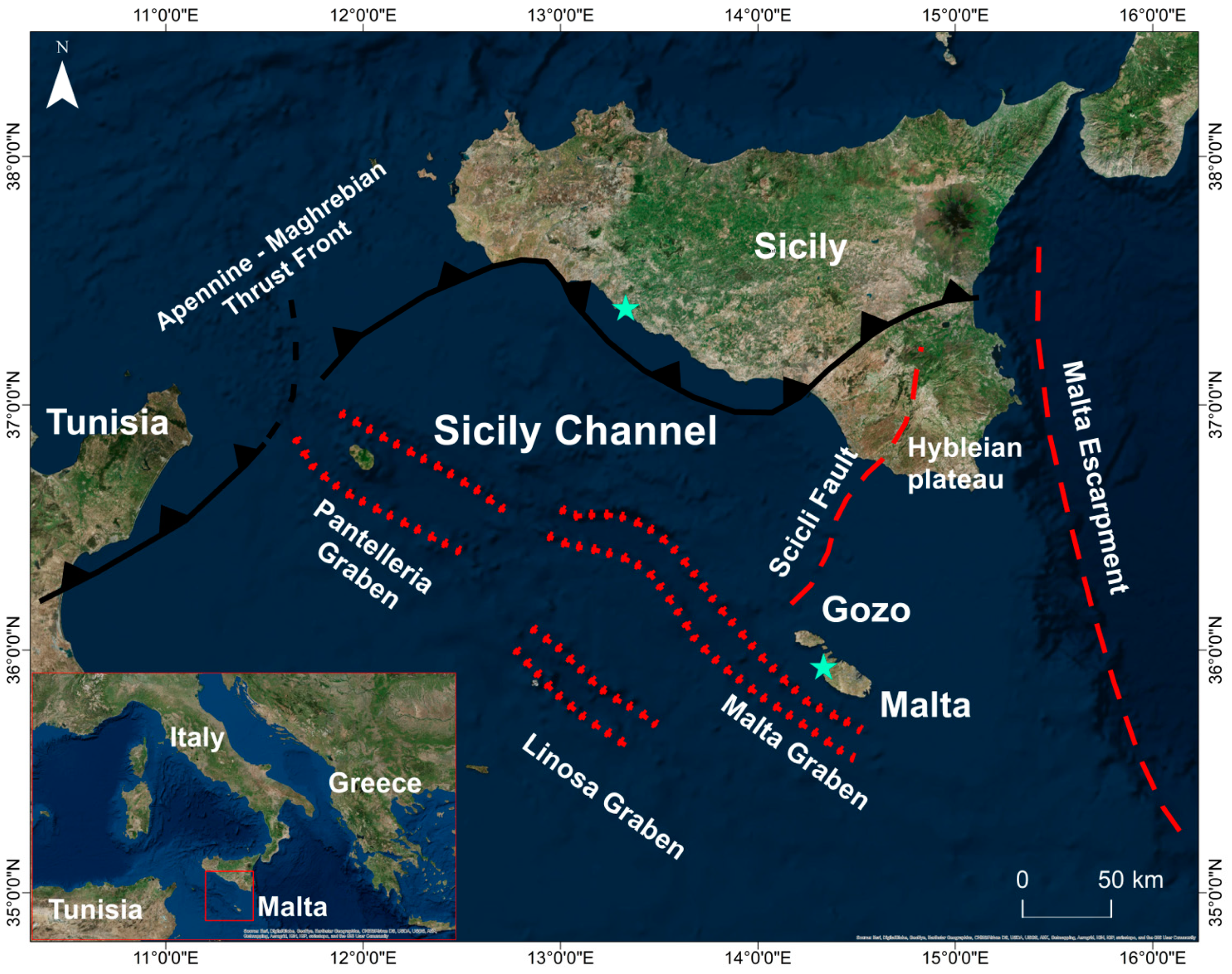
2. Malta and Sicily: Similarities and Differences
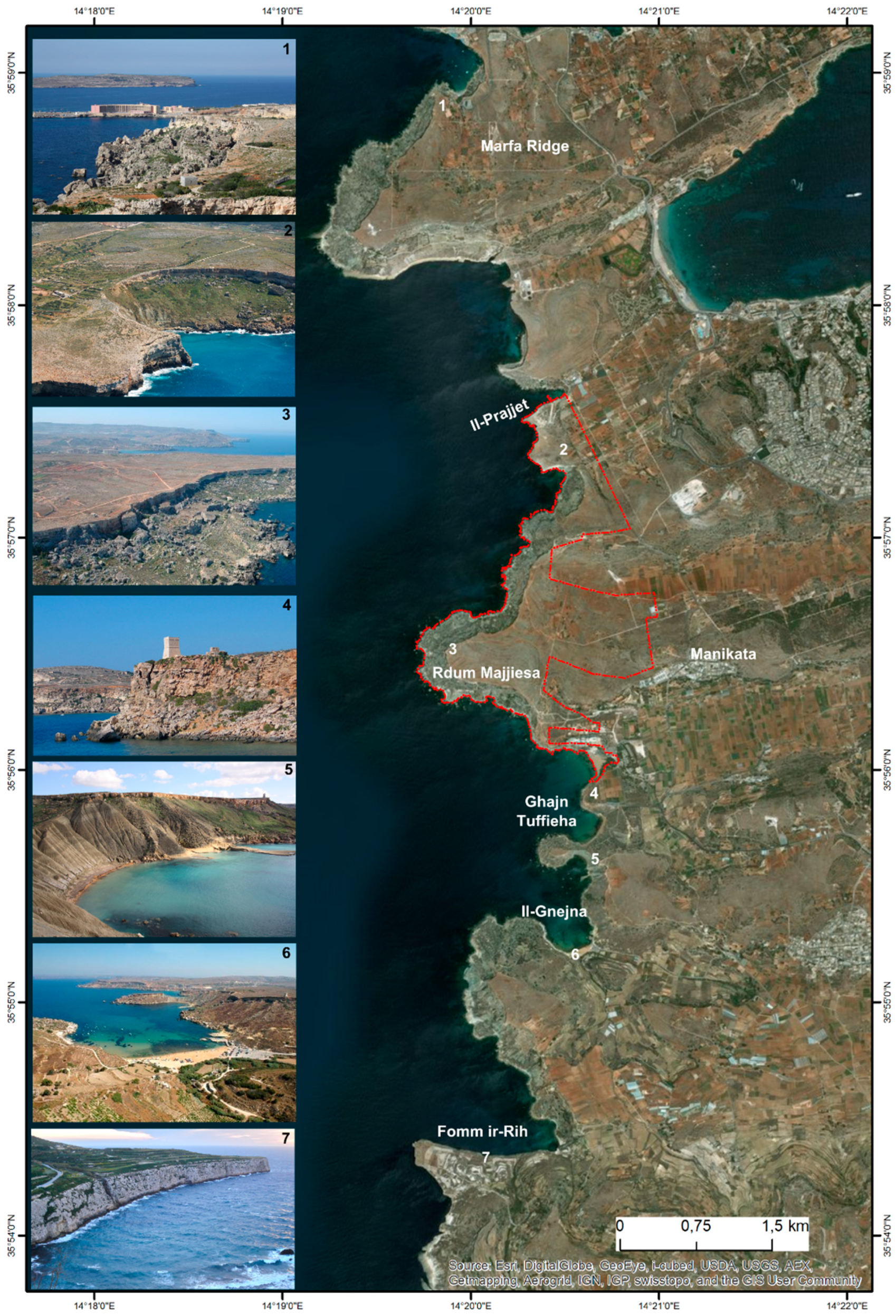
2.1. Malta Study Area
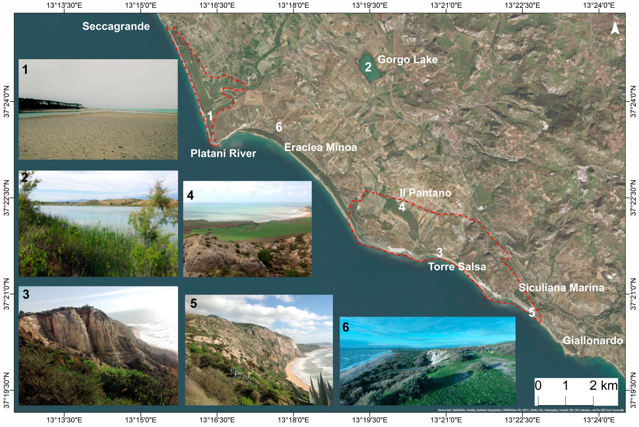
2.2. Sicily Study Area
3. Materials and Methods
3.1. Selection of Geosites
- The first criterion deals with the genesis of landforms [57]. It considers landforms that are representative of the main geomorphological processes (active and inactive) that have acted through time in the study areas.
- The second criterion concerns the spatial scale and refers to the spatial distribution of landforms. We have selected unique or rare landforms as well as more common and abundant ones. The selection based on this criterion aims to reflect the geo(morpho)diversity of the study areas [53].
- The third criterion concerns the temporal scale. The study areas are varied and dynamic, and combine active processes and landforms and inherited landforms which could be reactivated by currently active processes. In particular, active geosites (cf. [61,62]) have a high educational value because they allow us to: (i) understand and visualise geomorphological processes in action; (ii) envisage landscape evolution; (iii) highlight their relationship with present societies and their future development [63,64]. Inherited geosites (i.e., passive geosites [61,63], which take us back to the past and have a particular heritage value as records and symbols of Earth’s history and evolution. The selection based on this criterion aims to be representative of the study areas’ history and of their geomorphological evolution in time [53].
3.2. Quantitative Assessment of Geosites
3.3. Ranking of Geosites
- (1)
- MR = SV + (AV+UV)/2
- (2)
- TR = (AV+UV) + (SV/2)
4. Results
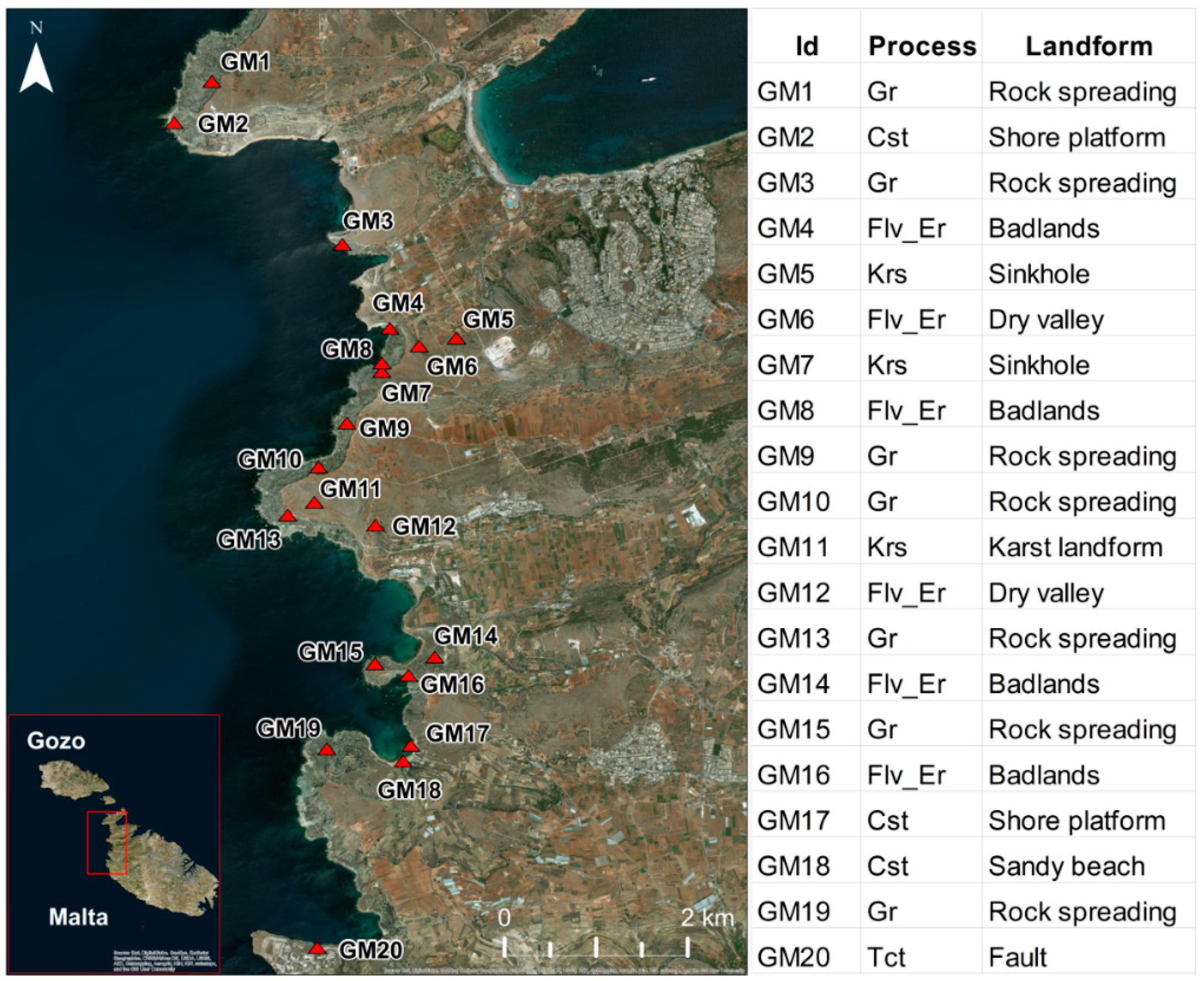
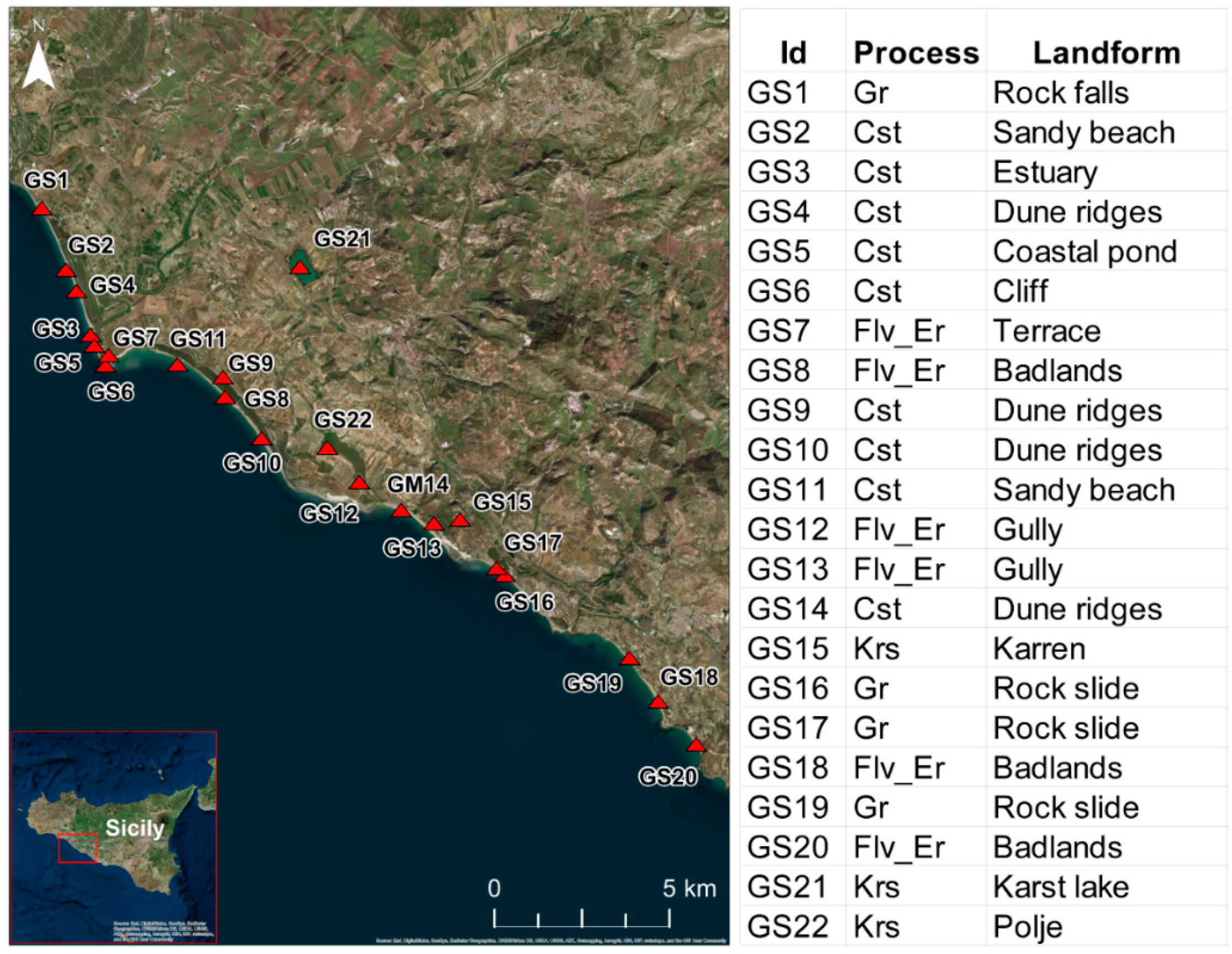
4.1. Selection of Geosites
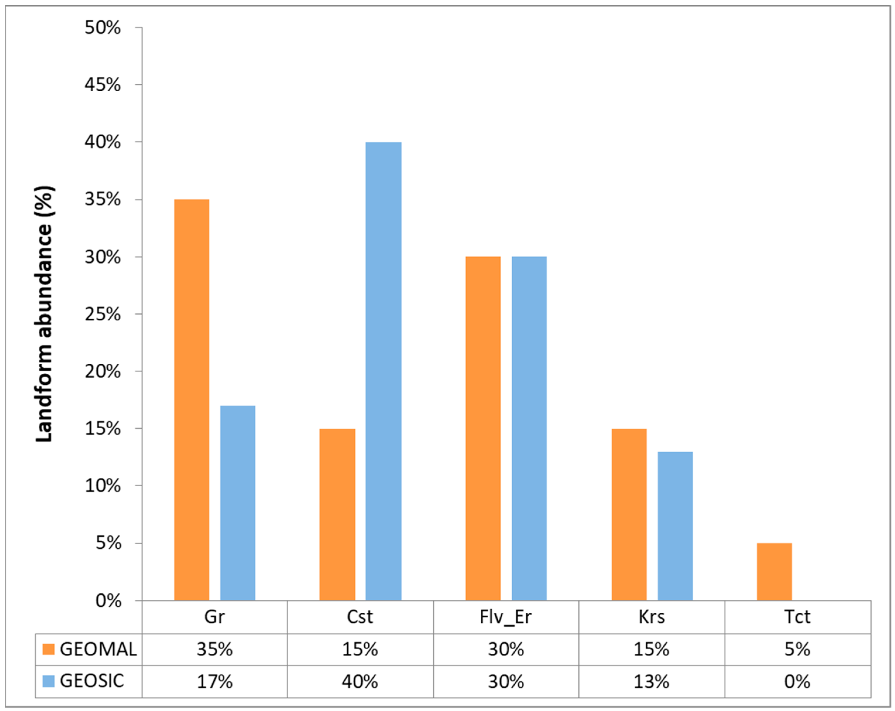
4.2. Quantitative Assessment and Ranking of Geosites
5. Conclusions
Author Contributions
Funding
Acknowledgments
Conflicts of Interest
References
- Hose, T.A. Selling the story of Britain’s stone. Environ. Interpret. 1995, 10, 16–17. [Google Scholar]
- Hose, T.A. European geotourism–geological interpretation and geoconservation promotion for tourists. In Geological Heritage: Its Conservation and Management; Barretino, D., Wimbledon, W.P., Gallego, E., Eds.; Instituto Tecnologico Geominero de España: Madrid, Spain, 2000; pp. 127–146. [Google Scholar]
- National Geographic Society. Available online: http://www.nationalgeographic.com/maps/geotourism/about (accessed on 29 May 2017).[Green Version]
- Joyce, B. Geotourism, Geosites and Geoparks: Working together in Australia. Aust. Geol. 2007, 144, 26–29. [Google Scholar]
- Dowling, R.K.; Newsome, D. Geotourism: Sustainability, Impacts and Management; Elsevier/Heineman Publishers: Oxford, UK, 2006. [Google Scholar]
- Dowling, R.K.; Newsome, D. (Eds.) Global Geotourism Perspectives; Goodfellow Publishers: Oxford, UK, 2010. [Google Scholar]
- Ollier, C. Problems of geotourism and geodiversity. Quaest. Geogr. 2012, 31, 57–61. [Google Scholar]
- Mansur, K.L.; Soares Da Silva, A. Society’s response: Assessment of the performance of the “Caminhos Geológicos” (“Geological Paths”) Project, State of Rio de Janeiro, Brazil. Geoheritage 2010, 3, 27–39. [Google Scholar] [CrossRef]
- Garavaglia, V.; Pelfini, M. Glacial geomorphosites and related landforms: A proposal for a dendrogeomorphological approach and educational trails. Geoheritage 2011, 3, 15–25. [Google Scholar] [CrossRef]
- Miccadei, E.; Piacentini, T.; Esposito, G. Geomorphosites and geotourism in the Parks of the Abruzzo Region (Central Italy). Geoheritage 2011, 3, 233–251. [Google Scholar] [CrossRef]
- Cardozo Moreira, J. Interpretative panels about the geological heritage—A case study at the Iguassu Falls National Park (Brazil). Geoheritage 2012, 4, 127–137. [Google Scholar] [CrossRef]
- Wrede, V.; Mügge-Bartolovicv, V. GeoRoute Ruhr—A network of geotrails in the Ruhr Area National GeoPark, Germany. Geoheritage 2012, 4, 109–114. [Google Scholar] [CrossRef]
- Enniouar, A.; Lagnaoui, A.; Adnane, H. A Middle Jurassic sauropod tracksite in the Argana Basin, Western High Atlas, Morocco: An example of paleoichnological heritage for sustainable geotourism. Proc. Geol. Assoc. 2014, 125, 114–119. [Google Scholar] [CrossRef]
- Gordon, J.E. Geoheritage, Geotourism and the Cultural Landscape: Enhancing the Visitor Experience and Promoting Geoconservation. Geosciences 2018, 8, 136. [Google Scholar] [CrossRef]
- Soldati, M.; Buhagiar, S.; Coratza, P.; Magri, O.; Pasuto, A.; Schembri, J.A. Integration of geomorphology and cultural heritage: A key issue for present and future times. Geogr. Fis. Dinam. Quat. 2008, 31, 95–96. [Google Scholar]
- Coratza, P.; Gauci, R.; Schembri, J.; Soldati, M.; Tonelli, C. Bridging Natural and Cultural Values of Sites with Outstanding Scenery: Evidence from Gozo, Maltese Islands. Geoheritage 2016, 8, 91–103. [Google Scholar] [CrossRef]
- Holloway, R. The Archaeology of Ancient Sicily; Routledge: London, UK, 1991. [Google Scholar]
- Bonanno, A. Malta, Phoenician, Punic and Roman; Midsea Books: Santa Venera, Malta, 2005. [Google Scholar]
- Bonanno, A. The Rise of a Maritime Strategic Island: Malta under the Phoenicians & the Romans. In Maritime History of Malta; The first Millennia; Cini, C., Borg, J., Eds.; Salesians of Don Bosco and Heritage Malta: Valletta, Malta, 2011; pp. 37–71. [Google Scholar]
- Cini, C.; Borg, J. (Eds.) The Maritime History of Malta; The first Millennia; Salesians of Don Bosco and Heritage Malta: Valletta, Malta, 2011. [Google Scholar]
- Dalli, C. Malta the Medieval Milennium; Midsea Books: Santa Venera, Malta, 2006. [Google Scholar]
- Brandhoff, R.E. Malta and Sicily. Island identity in the Mediterranean; the 700 BC turning point. In Kaleidoscope of Maritime Perspectives; Essay on the archeology, art history and landscape history of the maritime word view; Raemaekers, D.C.M., Ed.; University of Groningen/Groningen Institute of Archaeology and Barkhuis Publishing: Gronigen, The Netherlands, 2013. [Google Scholar]
- Cassar, C. A Concise History of Malta; Mireva Publications: Msida, Malta, 2000. [Google Scholar]
- Djamali, M.; Gambin, B.; Marriner, N.; Andrieu-Ponel, V.; Gambin, T.; Gandouin, E.; Lanfranco, S.; Medail, F.; Pavon, D.; Ponel, P.; et al. Vegetation dynamics during the early to mid-Holocene transition in NW Malta, human impact versus climatic forcing. Veg. Hist. Archaeobot. 2013, 22, 367–380. [Google Scholar] [CrossRef]
- Furlani, S.; Antonioli, F.; Biolchi, S.; Gambin, T.; Gauci, R.; Lo Presti, V.; Anzidei, M.; Devoto, S.; Palombo, M.; Sulli, A. Holocene sea level change in Malta. Quat. Int. 2013, 288, 146–157. [Google Scholar] [CrossRef] [Green Version]
- Lambeck, K.; Antonioli, F.; Anzidei, M.; Ferranti, L.; Leoni, G.; Scicchitano, G.; Silenzi, S. Sea level change along the Italian coast during the Holocene and projections for the future. Quat. Int. 2011, 232, 250–257. [Google Scholar] [CrossRef]
- Foglini, F.; Prampolini, M.; Micallef, A.; Angeletti, L.; Vandelli, V.; Deidun, A.; Soldati, M.; Taviani, M. Late Quaternary coastal landscape morphology and evolution of the Maltese Islands (Mediterranean Sea) reconstructed from high-resolution seafloor data. In Geology and Archaeology: Submerged Landscapes of the Continental Shelf; Harff, J., Bailey, G., Lüth, F., Eds.; Geological Society Special Publication: London, UK, 2016; Volume 411, pp. 77–95. [Google Scholar]
- Agnesi, V.; Di Patti, C.; Truden, B. Giants of Sicily: From myth to science. In Myth and Geology; Special Publications; Piccardi, L., Masse, W.B., Eds.; Geological Society: London, UK, 2007; Volume 273, pp. 263–270. [Google Scholar]
- Agnesi, V. Sicily in the last one million years. Bocconea 2004, 17, 23–32. [Google Scholar]
- Catalano, R.; Di Stefano, P.; Sulli, A.; Vitale, F.P. Paleogeography and structure of the central Mediterranean: Sicily and its offshore area. Tectonophysics 1996, 260, 291–323. [Google Scholar] [CrossRef]
- Prampolini, M.; Foglini, F.; Biolchi, S.; Devoto, S.; Angelini, S.; Soldati, M. Geomorphological mapping of terrestrial and marine areas, northern Malta and Comino (central Mediterranean Sea). J. Maps 2017, 13, 457–469. [Google Scholar] [CrossRef] [Green Version]
- Alexander, D. A review of the physical geography of Malta and its significance for tectonic geomorphology. Quat. Sci. Rev. 1988, 7, 41–53. [Google Scholar] [CrossRef]
- Devoto, S.; Biolchi, S.; Bruschi, V.M.; Furlani, S.; Mantovani, M.; Piacentini, D.; Pasuto, A.; Soldati, M. Geomorphological map of the NW Coast of the Island of Malta (Mediterranean Sea). J. Maps 2012, 8, 33–40. [Google Scholar] [CrossRef] [Green Version]
- Coratza, P.; Bruschi, V.; Piacentini, D.; Saliba, D.; Soldati, M. Recognition and assessment of Geomorphosites in Malta at the Il-Majjistral Natural and History Park. Geoheritage 2011, 3, 175–185. [Google Scholar] [CrossRef] [Green Version]
- Oil Exploration Directorate. Geological Map of the Maltese Islands; Office of the Prime Minister: Valletta, Malta, 1993.
- Pedley, M.; Clarke, M.H.; Galea, P. Limestone Isles in a Crystal Sea, the Geology of the Maltese Islands; Publishers Enterprises Group: San Gwann, Malta, 2002. [Google Scholar]
- Baldassini, N.; Di Stefano, A. Stratigraphic features of the Maltese Archipelago: A synthesis. Nat. Hazards 2017, 86 (Suppl. 2), 203–231. [Google Scholar] [CrossRef]
- Soldati, M.; Barrows, T.T.; Prampolini, M.; Fifield, K.L. Cosmogenic exposure dating constraints for coastal landslide evolution on the Island of Malta (Mediterranean Sea). J. Coast. Conserv. 2017, 1–14. [Google Scholar] [CrossRef]
- Magri, O.; Mantovani, M.; Pasuto, A.; Soldati, M. Geomorphological investigation and monitoring of lateral spreading phenomena along the north-west coast of Malta. Geogr. Fis. Dinam. Quat. 2008, 31, 171–180. [Google Scholar]
- Mantovani, M.; Devoto, S.; Forte, E.; Mocnik, A.; Pasuto, A.; Piacentini, D.; Soldati, M. A multidisciplinary approach for rock spreading and block sliding investigation in the north-western coast of Malta. Landslides 2012. [Google Scholar] [CrossRef]
- Said, G.; Schembri, J. Malta. In Encyclopaedia of the World’s Coastal Landforms; Bird, E., Ed.; Springer: Dordrecht, The Netherlands, 2010; pp. 751–759. [Google Scholar]
- Cyffka, B.; Bock, M. Degradation of field terraces in the Maltese Islands—Reasons, processes and effects. Geogr. Fis. Dinam. Quat. 2008, 31, 119–128. [Google Scholar]
- Di Maggio, C.; Madonia, G.; Vattano, M.; Agnesi, V.; Monteleone, S. Geomorphological evolution of Western Sicily, Italy. Geol. Carpath. 2017, 68, 80–93. [Google Scholar] [CrossRef]
- Barba, F.J.; Remondo, J.; Rivas, V. Propuesta de un procedimiento para armonizar la valoración de elementos del patrimonio geológico. ZUBIA 1997, 15, 11–20. [Google Scholar]
- Rivas, V.; Rix, K.; Frances, A.; Cendrero, A.; Brunsden, D. Geomorphological indicators for environmental impact assessment: Consumable and non-consumable geomorphological resources. Geomorphology 1997, 18, 169–182. [Google Scholar] [CrossRef]
- Coratza, P.; Giusti, C. Methodological proposal for the assessment of the scientific quality of geomorphosites. Il Quat. Ital. J. Quat. Sci. 2005, 18, 303–313. [Google Scholar]
- Bruschi, V.M.; Cendrero, A. Geosite evaluation: Can we measure intangible values? Il Quat. Ital. J. Quat. Sci. 2005, 18, 293–306. [Google Scholar]
- Bruschi, V.M.; Cendrero, A. Direct and parametric methods for the assessment of geosites and geomorphosites. In Geomorphosites; Reynard, E., Coratza, P., Regolini-Bissig, G., Eds.; Pfeil: München, Germany, 2009; pp. 73–88. [Google Scholar]
- Serrano, E.; González-Trueba, J.J. Assessment of geomorphosites in natural protected areas: The Picos de Europa National Park (Spain). Géomorphologie 2005, 3, 197–208. [Google Scholar] [CrossRef]
- Reynard, E.; Fontana, G.; Kozlik, L.; Scapozza, C. A method for assessing the scientific and additional values of geomorphosites. Geogr. Helv. 2007, 62, 148–158. [Google Scholar] [CrossRef]
- Pererira, D.I.; Pereira, P.; Brilha, J.; Cunha, P.P. The Iberian Massif Landscape and Fluvial Network in Portugal: A geoheritage inventory based on the scientific value. Proc. Geol. Assoc. 2015, 126, 252–265. [Google Scholar] [CrossRef]
- Brilha, J. Inventory and quantitative assessment of geosites and geodiversity sites: A review. Geoheritage 2016, 8, 119–134. [Google Scholar] [CrossRef] [Green Version]
- Reynard, E.; Perret, A.; Bussard, J.; Grangier, L.; Martin, S. Integrated Approach for the Inventory and Management of Geomorphological Heritage at the Regional Scale. Geoheritage 2016, 8, 43–60. [Google Scholar] [CrossRef]
- Pralong, J.P. A method for assessing the tourist potential and use of geomorphological sites. Géomorphologie 2005, 3, 189–196. [Google Scholar] [CrossRef]
- Kubalíková, L. Geomorphosite assessment for geotourism purposes. Czech J. Tour. 2013, 2, 80–104. [Google Scholar] [CrossRef] [Green Version]
- Zouros, N. Geomorphosite assessment and management in protected areas of Greece. Case study of the Lesvos Island-coastal geomorphosites. Geogr. Helv. 2007, 62, 69–180. [Google Scholar] [CrossRef]
- Feuillet, T.; Sourp, E. Geomorphological heritage of the Pyrenees National Park (France): Assessment, Clustering, and Promotion of Geomorphosites. Geoheritage 2011, 3, 151–162. [Google Scholar] [CrossRef]
- Pellitero, R.; González-Amuchastegui, M.J.; Ruiz-Flaño, P.; Serrano, E. Geodiversity and Geomorphosite Assessment Applied to a Natural Protected Area: The Ebro and Rudron Gorges Natural Park (Spain). Geoheritage 2011, 3, 163–174. [Google Scholar] [CrossRef]
- Comănescu, L.; Nedelea, R.; Dobre, R. The Evaluation of Geomorphosites from the Ponoare Protected Area. Studii și Cercetări de Geografie și Protecția Mediului 2012, 11, 54–61. [Google Scholar] [CrossRef]
- Coratza, P.; Galve, J.P.; Soldati, M.; Tonelli, C. Recognition and assessment of sinkholes as geosites: Lessons from the Island of Gozo (Malta). Quaest. Geogr. 2012, 31, 25–35. [Google Scholar] [CrossRef]
- Reynard, E. Protecting Stones: Conservation of erratic blocks in Switzerland. In Dimension Stone 2004. New Perspectives for a Traditional Building Material; Prykril, R., Ed.; A.A. Balkema Publishers: Leiden, The Netherlands, 2004; pp. 3–7. [Google Scholar]
- Reynard, E. Géomorphosites et paysages. Géomorphologie 2005, 3, 181–188. [Google Scholar] [CrossRef]
- Pelfini, M.; Bollati, I. Landforms and geomorphosites ongoing changes: Concepts and implications for geoheritage promotion. Quaest. Geogr. 2014, 33, 131–143. [Google Scholar] [CrossRef]
- Reynard, E.; Coratza, P. The importance of mountain geomorphosites for environmental education. Examples from the Italian Dolomites and the Swiss Alps. Acta Geogr. 2016, 56, 291–303. [Google Scholar] [CrossRef]
- Brilha, J. Geoheritage: Inventories and evaluation. In Geoheritage: Assessment, Protection and Management; Reynard, E., Brilha, J., Eds.; Elsevier: Amsterdam, The Netherlands, 2018; pp. 69–86. [Google Scholar]
- Goudie, A.S. Aesthetics and relevance in geomorphological outreach. Geomorphology 2004, 47, 245–249. [Google Scholar] [CrossRef]
- Migoń, P. Stories behind superlative scenery. World Herit. 2012, 63, 18–25. [Google Scholar]
- Różycka, M.; Migoń, P. Customer-Oriented Evaluation of Geoheritage—On the Example of Volcanic Geosites in the West Sudetes, SW Poland. Geoheritage 2018, 10, 23–37. [Google Scholar] [CrossRef]
- Božić, S.; Tomić, N.; Pavić, D. Canyons as a potential geotourism attractions of Serbia—Comparative analysis of Lazar and Uvac canyons by using M-GAM model. Acta Geoturist. 2014, 5, 18–30. [Google Scholar]


| Value | Criteria | Numerical Range | |
|---|---|---|---|
| Scientific value (maximum 4) | Palaeo-geomorphological model | 0–1 | |
| Rareness | 0–1 | ||
| Representativeness | 0–1 | ||
| Integrity | 0–1 | ||
| Additional values (maximum 3) | Ecological value | Ecological support role | 0–0.5 |
| Protected site | 0–0.5 | ||
| Aesthetic value | Panoramic quality | 0–0.25 | |
| Colour diversity | 0–0.25 | ||
| Vertical development | 0–0.25 | ||
| Naturalness | 0–0.25 | ||
| Cultural value | Religious importance | 0–0.33 | |
| Historical importance | 0–0.33 | ||
| Artistic importance | 0–0.33 | ||
| Use value (maximum 3) | Accessibility | 0–0.75 | |
| Visibility | 0–0.75 | ||
| Services | 0–0.75 | ||
| Importance for education | 0–0.75 | ||
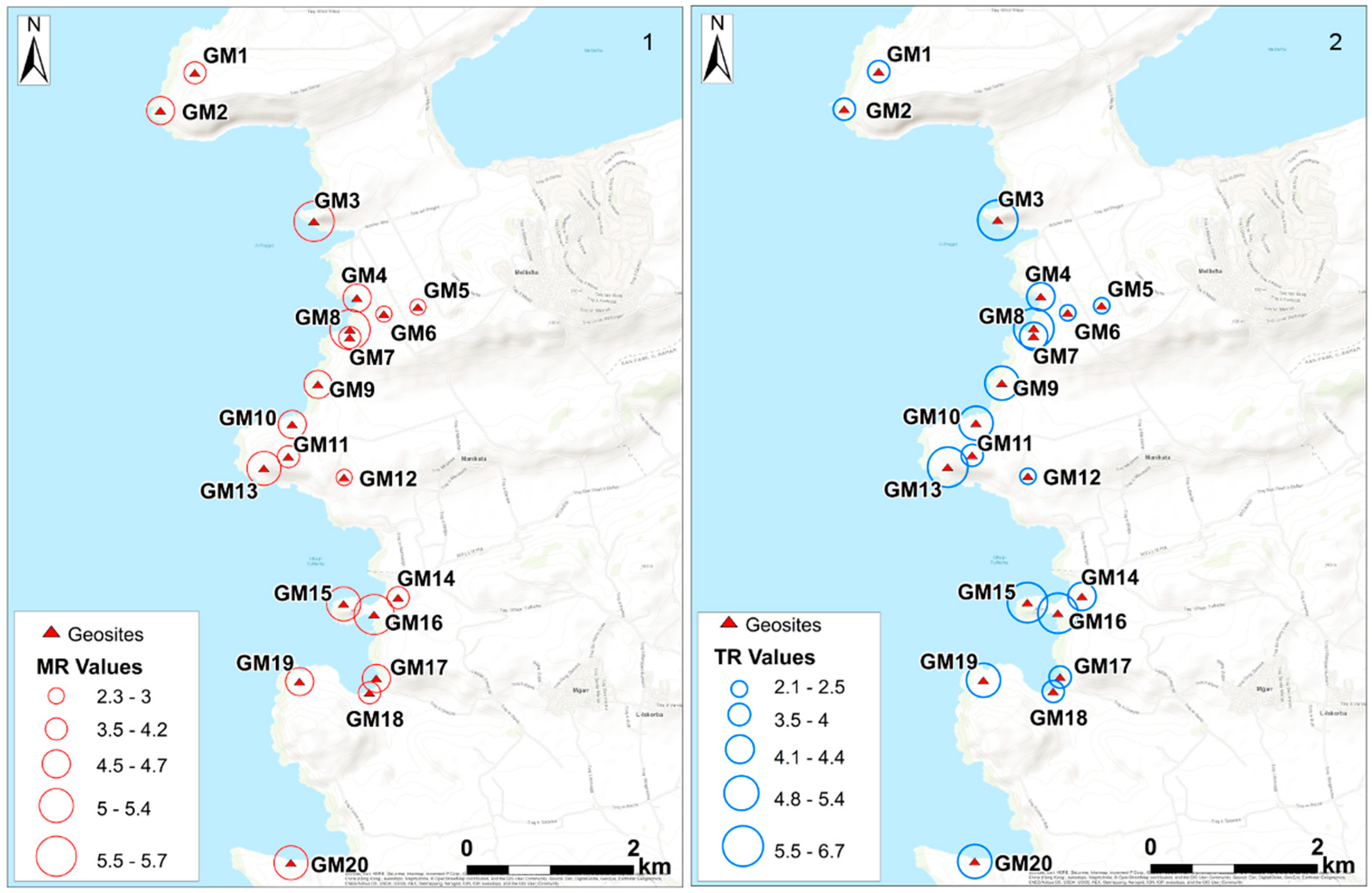
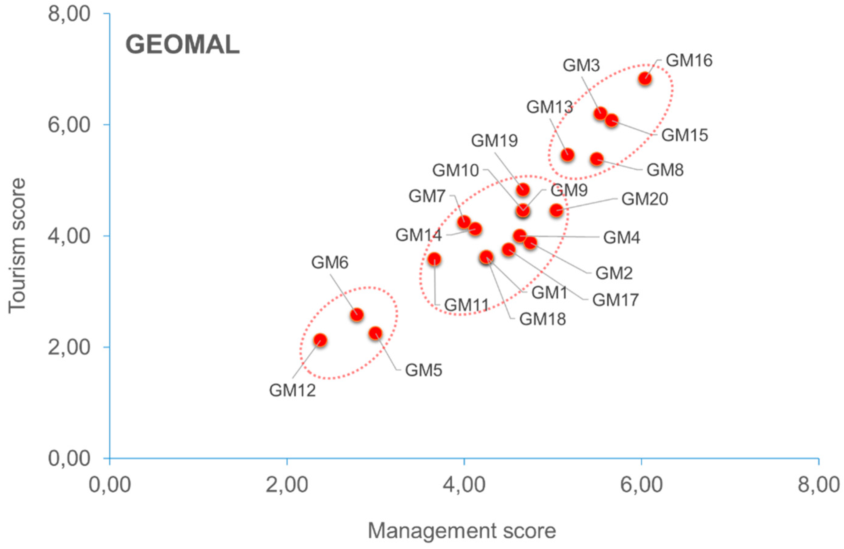
| Malta Geosites | SV | AV | UV | Total | MR | TR | Management Ranking | Tourism Ranking |
|---|---|---|---|---|---|---|---|---|
| GM1 | 3.25 | 0.75 | 1.25 | 5.25 | 4.25 | 3.63 | 13 | 17 |
| GM2 | 3.75 | 0.75 | 1.25 | 5.75 | 4.75 | 3.88 | 7 | 13 |
| GM3 | 3.25 | 1.58 | 3 | 7.83 | 5.54 | 6.21 | 3 | 2 |
| GM4 | 3.5 | 1.25 | 1 | 5.75 | 4.63 | 4.00 | 11 | 12 |
| GM5 | 2.5 | 0.25 | 0.75 | 3.5 | 3.00 | 2.25 | 18 | 19 |
| GM6 | 2 | 1.08 | 0.5 | 3.58 | 2.79 | 2.58 | 19 | 18 |
| GM7 | 2.5 | 1.5 | 1.5 | 5.5 | 4.00 | 4.25 | 16 | 10 |
| GM8 | 3.75 | 1.5 | 2 | 7.25 | 5.50 | 5.38 | 4 | 5 |
| GM9 | 3.25 | 1.58 | 1.25 | 6.08 | 4.67 | 4.46 | 8 | 7 |
| GM10 | 3.25 | 1.58 | 1.25 | 6.08 | 4.67 | 4.46 | 9 | 8 |
| GM11 | 2.5 | 1.08 | 1.25 | 4.83 | 3.67 | 3.58 | 17 | 16 |
| GM12 | 1.75 | 0.75 | 0.5 | 3 | 2.38 | 2.13 | 20 | 20 |
| GM13 | 3.25 | 1.33 | 2.5 | 7.08 | 5.17 | 5.46 | 5 | 4 |
| GM14 | 2.75 | 1 | 1.75 | 5.5 | 4.13 | 4.13 | 15 | 11 |
| GM15 | 3.5 | 2.33 | 2 | 7.83 | 5.67 | 6.08 | 2 | 3 |
| GM16 | 3.5 | 2.33 | 2.75 | 8.58 | 6.04 | 6.83 | 1 | 1 |
| GM17 | 3.5 | 0.75 | 1.25 | 5.5 | 4.50 | 3.75 | 12 | 14 |
| GM18 | 3.25 | 1 | 1 | 5.25 | 4.25 | 3.63 | 14 | 15 |
| GM19 | 3 | 1.08 | 2.25 | 6.33 | 4.67 | 4.83 | 10 | 6 |
| GM20 | 3.75 | 1.33 | 1.25 | 6.33 | 5.04 | 4.46 | 6 | 9 |
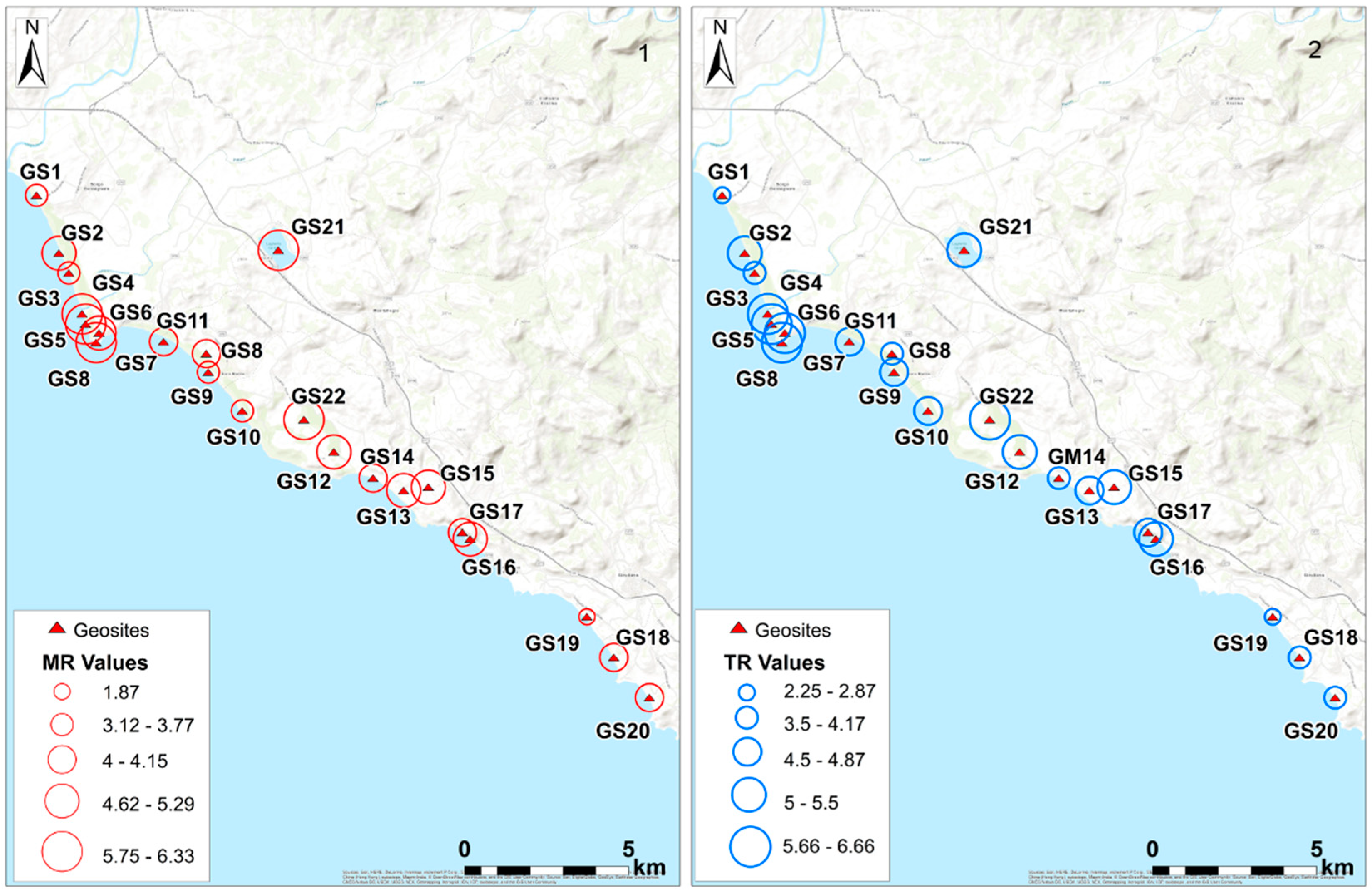
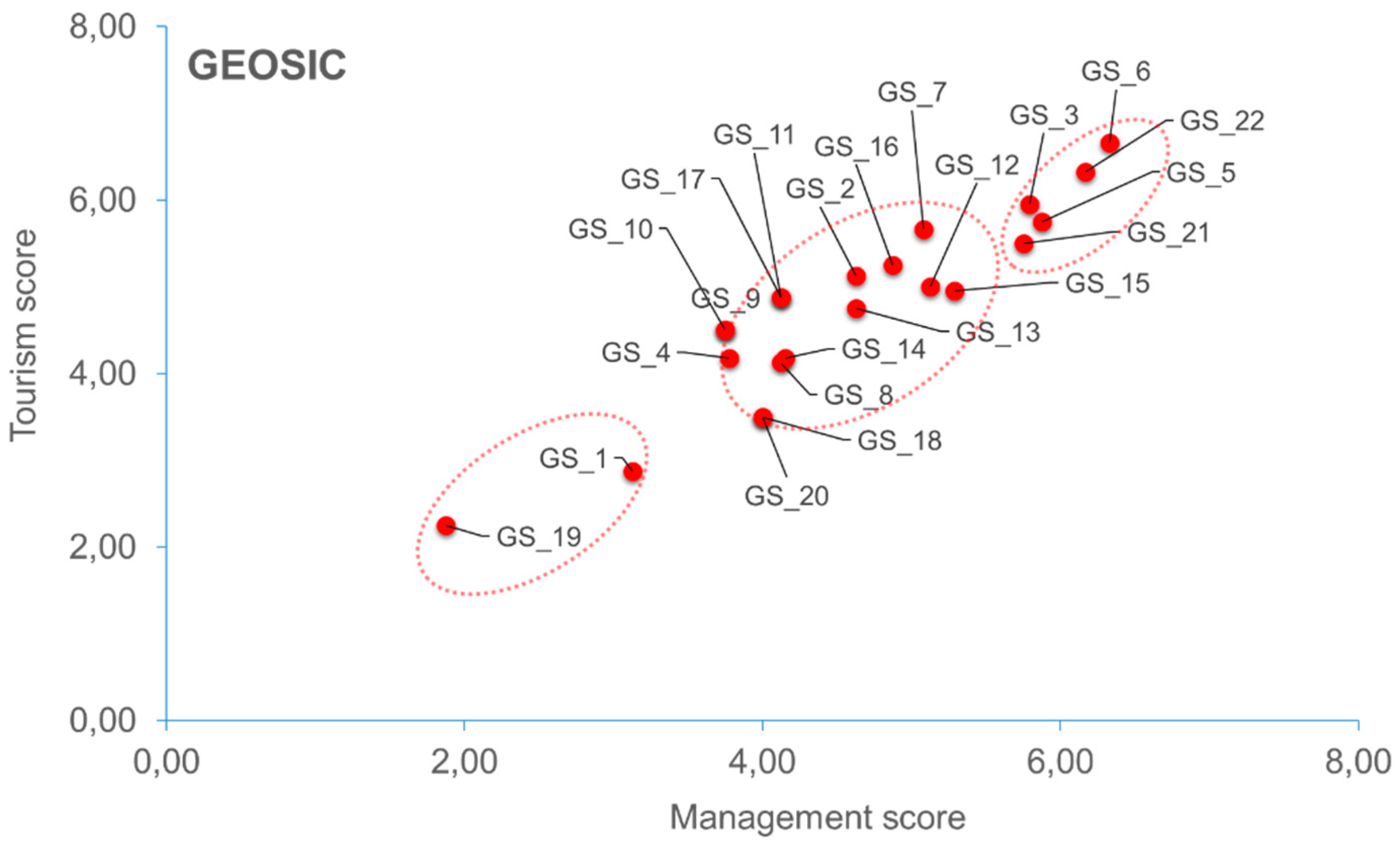
| Sicily Geosites | SV | AV | UV | Total | MR | TR | Management Ranking | Tourism Ranking |
|---|---|---|---|---|---|---|---|---|
| GS1 | 2.25 | 0.5 | 1.25 | 4 | 3.13 | 2.88 | 21 | 21 |
| GS2 | 2.75 | 1.75 | 2.00 | 6.5 | 4.63 | 5.13 | 11 | 8 |
| GS3 | 3.75 | 2.08 | 2.00 | 7.83 | 5.79 | 5.96 | 4 | 3 |
| GS4 | 2.25 | 1.75 | 1.30 | 5.3 | 3.78 | 4.18 | 5 | 16 |
| GS5 | 4 | 1.75 | 2.00 | 7.75 | 5.88 | 5.75 | 3 | 4 |
| GS6 | 4 | 2.66 | 2.00 | 8.66 | 6.33 | 6.66 | 2 | 1 |
| GS7 | 3 | 1.91 | 2.25 | 7.16 | 5.08 | 5.66 | 9 | 5 |
| GS8 | 2.75 | 1.75 | 1.00 | 5.5 | 4.13 | 4.13 | 14 | 18 |
| GS9 | 2 | 1 | 2.50 | 5.5 | 3.75 | 4.50 | 19 | 13 |
| GS10 | 2 | 1 | 2.50 | 5.5 | 3.75 | 4.50 | 20 | 14 |
| GS11 | 2.25 | 1 | 2.75 | 6 | 4.13 | 4.88 | 15 | 11 |
| GS12 | 3.5 | 1 | 2.25 | 6.75 | 5.13 | 5.00 | 8 | 9 |
| GS13 | 3 | 1 | 2.25 | 6.25 | 4.63 | 4.75 | 12 | 15 |
| GS14 | 2.75 | 1.5 | 1.30 | 5.55 | 4.15 | 4.18 | 13 | 17 |
| GS15 | 3.75 | 1.83 | 1.25 | 6.83 | 5.29 | 4.96 | 7 | 10 |
| GS16 | 3 | 1 | 2.75 | 6.75 | 4.88 | 5.25 | 10 | 7 |
| GS17 | 2.25 | 1 | 2.75 | 6 | 4.13 | 4.88 | 16 | 12 |
| GS18 | 3 | 1 | 1.00 | 5 | 4.00 | 3.50 | 17 | 19 |
| GS19 | 1 | 1 | 0.75 | 2.75 | 1.88 | 2.25 | 22 | 22 |
| GS20 | 3 | 1 | 1.00 | 5 | 4.00 | 3.50 | 18 | 20 |
| GS21 | 4 | 1.25 | 2.25 | 7.5 | 5.75 | 5.50 | 6 | 6 |
| GS22 | 4 | 2.08 | 2.25 | 8.33 | 6.17 | 6.33 | 1 | 2 |
© 2018 by the authors. Licensee MDPI, Basel, Switzerland. This article is an open access article distributed under the terms and conditions of the Creative Commons Attribution (CC BY) license (http://creativecommons.org/licenses/by/4.0/).
Share and Cite
Cappadonia, C.; Coratza, P.; Agnesi, V.; Soldati, M. Malta and Sicily Joined by Geoheritage Enhancement and Geotourism within the Framework of Land Management and Development. Geosciences 2018, 8, 253. https://doi.org/10.3390/geosciences8070253
Cappadonia C, Coratza P, Agnesi V, Soldati M. Malta and Sicily Joined by Geoheritage Enhancement and Geotourism within the Framework of Land Management and Development. Geosciences. 2018; 8(7):253. https://doi.org/10.3390/geosciences8070253
Chicago/Turabian StyleCappadonia, Chiara, Paola Coratza, Valerio Agnesi, and Mauro Soldati. 2018. "Malta and Sicily Joined by Geoheritage Enhancement and Geotourism within the Framework of Land Management and Development" Geosciences 8, no. 7: 253. https://doi.org/10.3390/geosciences8070253