
Living with the Risks of Cyclone Disasters in the South-Western Coastal Region of Bangladesh


Abstract
:1. Introduction
- (a)
- How did the communities perceive (pre-event) cyclone disasters?
- (b)
- What were the activities (post-event) undertaken by the affected communities to recover from the cyclone disasters?
- (c)
- What changes took place at individual and household level?
2. Literature Review
3. Methodology
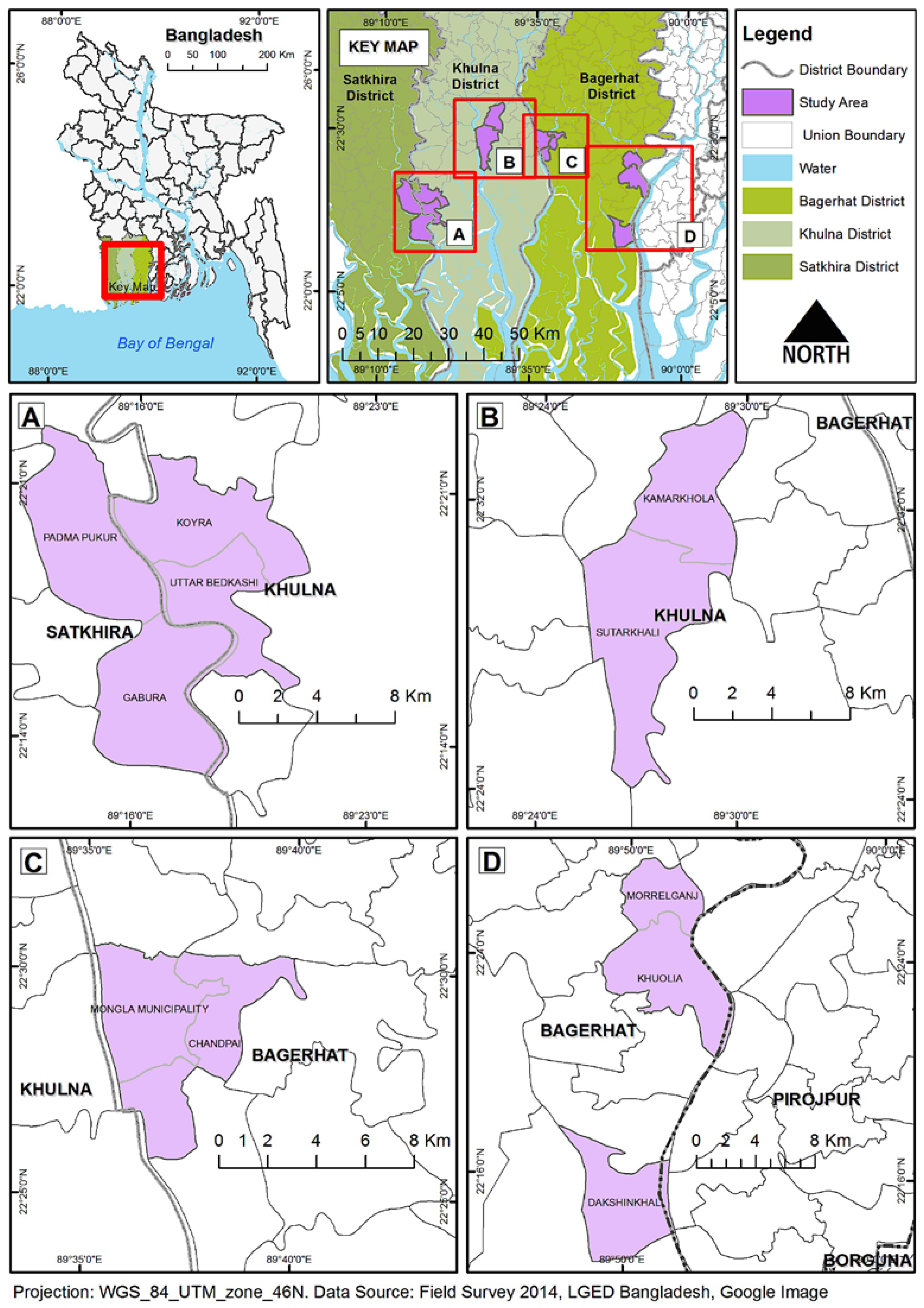
3.1. Study Area
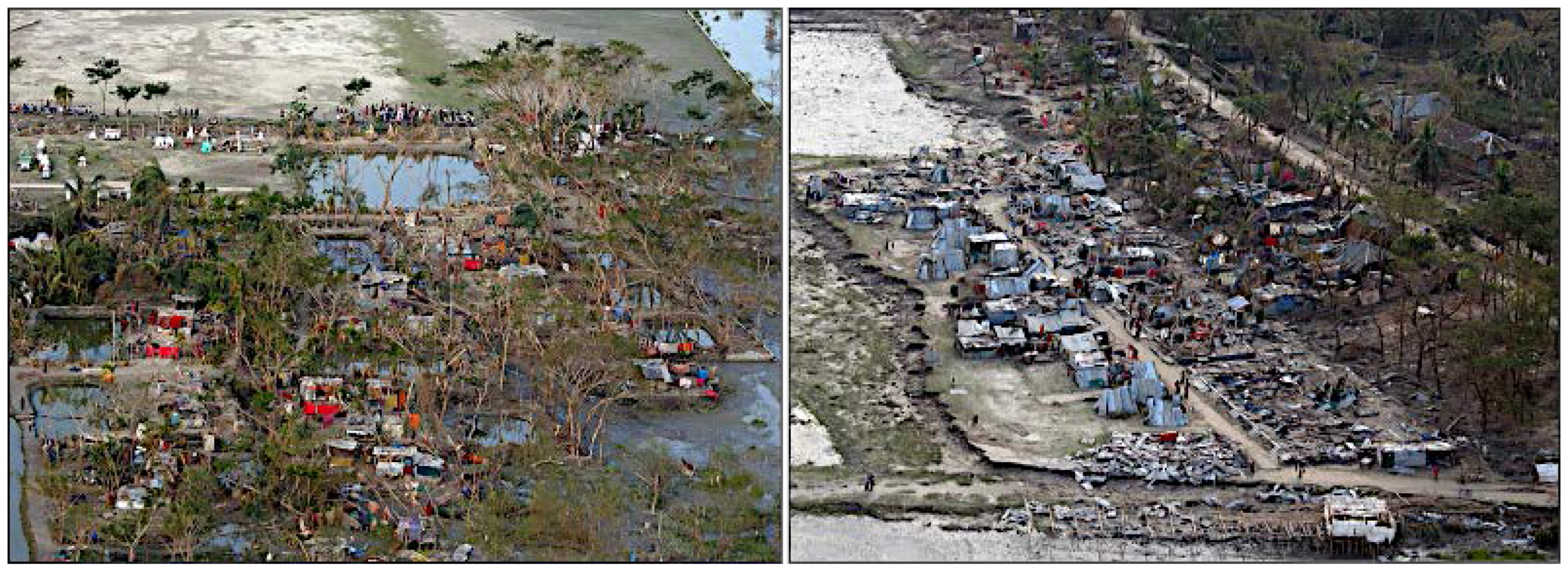
3.1.1. Devastation of Cyclone Sidr
3.1.2. Devastation of Cyclone Aila
3.2. Data Collection
3.2.1. Household Based Questionnaire Surveying
3.2.2. Focus Group Discussion
3.2.3. In-Depth Interviews/Case Study
3.2.4. Geographic Survey
3.2.5 Construction of Social Supremacy Index (SSI)
4. Results and Discussion
4.1. Socio-Economic Profile of the Respondents
4.2. Pre-Event Situation
4.3. Preparedness and Confronting Disasters
4.4. Post-Event Situation
4.5. Alternatives to Adapt to Adverse Situations
4.5.1. Changes in Occupation
4.5.2. Micro-Credit as an Alternative
4.5.3. Migration as an Alternative
5. Conclusions
Acknowledgments
Author Contributions
Conflicts of Interest
References
- Subcommittee on Disaster Reduction (SDR). Reducing Disaster Vulnerability through Science and Technology; An Interim Report of the Subcommittee on Disaster Reduction, National Science and Technology Council, Executive Office of the President of the United States; SDR: Washington, DC, USA, 2003.
- United Nations University–Institute for Environment and Human Security (UNU–EHS). World Risk Report 2016; UNU-EHS: Bonn, Germany, 2016. [Google Scholar]
- Mallick, B.; Vogt, J. Social Supremacy and Its Role in Local Level Disaster Mitigation Planning in Bangladesh. Disaster Prev. Manag. 2011, 20, 543–556. [Google Scholar] [CrossRef]
- Mallick, B. Der Gesellschaftliche Umgang mit Zunehmender Verwundbarkeit: Eine Analyse der Sozialen Bedingungen fuer Vulnerabilitaetsorientierte Raeumliche Planung in den Kuestenzonen von Bangladesch, Regional Science Research 2014; KIT Scientific Publishing: Karlsruhe, Germany, 2014. [Google Scholar]
- Auerbach, L.W.; Goodbred, S.L., Jr.; Mondal, D.R.; Wilson, C.A.; Ahmed, K.R.; Roy, K.; Steckler, M.S.; Small, C.; Gilligan, J.M.; Ackerly, B.A. Flood risk of natural and embanked landscapes on the Ganges–Brahmaputra tidal delta plain. Nat. Clim. Chang. 2015, 5, 153–157. [Google Scholar] [CrossRef]
- Ahmed, B.; Kelman, I.; Fehr, H.K.; Saha, M. Community Resilience to Cyclone Disasters in Coastal Bangladesh. Sustainability 2016, 8, 805. [Google Scholar] [CrossRef]
- O’Keefe, P.; Westgate, K.; Wisner, B. Taking naturalness out of natural disasters. Nature 1976, 260, 566–567. [Google Scholar] [CrossRef]
- Wisner, B.; Blaikie, P.; Cannon, T.; Davis, I. At Risk: Natural Hazards, People’s Vulnerability and Disasters, 2nd ed.; Routledge: London, UK, 2004. [Google Scholar]
- Hewitt, K. Interpretations of Calamity from the Viewpoint of Human Ecology, 1st ed.; Allen & Unwin: London, UK, 1983. [Google Scholar]
- Alexander, D.E. Resilience and disaster risk reduction: An etymological journey. Nat. Hazards Earth Syst. Sci. 2013, 13, 2707–2716. [Google Scholar] [CrossRef]
- Mallick, B. Necessity of acceptance? Searching for a sustainable community-based disaster mitigation approach—The example of a coastal city in Bangladesh. In Solutions to Coastal Disasters 2011; Wallendorf, L.A., Jones, C., Ewing, L., Battalio, B., Eds.; American Society of Civil Engineers (ASCE) and Coasts, Oceans, Ports and River Institute (COPRI): Reston, VA, USA, 2011; pp. 753–766. [Google Scholar]
- Emanuel, K.; Sundararajan, R.; Williams, J. Hurricanes and Global Warming: Results from Downscaling IPCC AR4 Simulations. Bull. Am. Meteorol. Soc. 2008, 89, 347–367. [Google Scholar] [CrossRef]
- Teka, O.; Vogt, J. Social perception of natural risks by local residents in developing countries—The example of the coastal area of Benin. Soc. Sci. J. 2010, 47, 215–224. [Google Scholar] [CrossRef]
- Wisner, B.; Luce, H.R. Disaster vulnerability: Scale, power and daily life. Geojournal 1993, 30, 127–140. [Google Scholar] [CrossRef]
- Hulme, M. 1.5 °C and climate research after the Paris Agreement. Nat. Clim. Chang. 2016, 6, 222–224. [Google Scholar] [CrossRef]
- Intergovernmental Panel on Climate Change. Climate Change 2014: Synthesis Report; Contribution of Working Groups I, II and III to the Fifth Assessment Report of the Intergovernmental Panel on Climate Change (IPCC); Intergovernmental Panel on Climate Change: Geneva, Switzerland, 2014. [Google Scholar]
- Dow, K.; Berkhout, F.; Preston, B.L.; Klein, R.J.T.; Midgley, G.; Shaw, M.R. Limits to adaptation. Nat. Clim. Chang. 2013, 3, 305–307. [Google Scholar] [CrossRef]
- Siddiqui, T.; Islam, M.T.; Kniveton, D.; Black, R.; Martin, M. The Staggering Scale of Climate-Related Migration and the Need for Pro-Poor Policies; Climate Change-Related Migration in Bangladesh, Briefing Paper No. 5; Refugee and Migratory Movements Research Unit, University of Dhaka: Dhaka, Bangladesh, 2013. [Google Scholar]
- Sultana, Z.; Mallick, B. Adaptation Strategies after Cyclone in Southwest Coastal Bangladesh—Pro Poor Policy Choices. Am. J. Rural Dev. 2015, 3, 24–33. [Google Scholar] [CrossRef]
- Shameem, M.I.M.; Momtaz, S.; Kiem, A.S. Local perceptions of and adaptation to climate variability and change: The case of shrimp farming communities in the coastal region of Bangladesh. Clim. Chang. 2015, 133, 253–266. [Google Scholar] [CrossRef]
- Paul, B.; Rashid, H. Climatic Hazards in Coastal Bangladesh: Non-Structural and Structural Solutions, 1st ed.; Butterworth-Heinemann: Oxford, UK, 2016. [Google Scholar]
- Das, D.; Mallick, B.; Vogt, J. Social process analysis in poverty alleviation program: A study of Khas-land distribution in rural Bangladesh. J. Bangladesh Inst. Plan. 2012, 5, 25–36. [Google Scholar]
- Huq, N.; Hugé, J.; Boon, E.; Gain, A.K. Climate Change Impacts in Agricultural Communities in Rural Areas of Coastal Bangladesh: A Tale of Many Stories. Sustainability 2015, 7, 8437–8460. [Google Scholar] [CrossRef]
- Choudhury, J.R. Cyclone Shelter and Its Multipurpose Use; Bangladesh University of Engineering and Technology: Dhaka, Bangladesh, 1992. [Google Scholar]
- Brouwer, R.; Akter, S.; Brander, L.; Haque, E. Socioeconomic vulnerability and adaptation to environmental risk: A case study of climate change and flooding in Bangladesh. Risk Anal. 2007, 27, 313–326. [Google Scholar] [CrossRef] [PubMed]
- Khalil, G.M. The Catastrophic Cyclone of April 1991: Its Impact on the Economy of Bangladesh. Nat. Hazards 1993, 8, 263–281. [Google Scholar] [CrossRef]
- Paul, B.K. Why relatively fewer people died? The case of Bangladesh’s Cyclone Sidr. Nat. Hazards 2009, 50, 289–304. [Google Scholar] [CrossRef]
- Cutter, S.; Barnes, L.; Berry, M.; Burton, C.; Evans, E.; Tate, E.; Webb, J. A place-based model for understanding community resilience to natural disasters. Glob. Environ. Chang. 2008, 18, 598–606. [Google Scholar] [CrossRef]
- Yamin, F.; Rahman, A.; Huq, S. Vulnerability, adaptation and climate disasters: A conceptual overview. IDS Bull. 2005, 36, 1–14. [Google Scholar] [CrossRef] [Green Version]
- Shameem, M.I.M.; Momtaz, S. Vulnerability of rural livelihoods to multiple stressors: A case study from the southwest coastal region of Bangladesh. Ocean Coast. Manag. 2014, 23–38. [Google Scholar] [CrossRef]
- Mirza, M.M.Q. Diversion of the Ganges Water at Farakka and its effects on salinity in Bangladesh. Environ. Manag. 1998, 22, 711–722. [Google Scholar] [CrossRef]
- Mallick, B.; Rahaman, K.R.; Vogt, J. Coastal livelihood and physical infrastructure in Bangladesh after Cyclone Aila. Mitig. Adapt. Strateg. Glob. Chang. 2011, 16, 629–648. [Google Scholar] [CrossRef]
- Mallick, B.; Vogt, J. Cyclone, Coastal Society and Migration. Int. Dev. Plan. Rev. 2012, 34, 217–240. [Google Scholar] [CrossRef]
- Dasgupta, S.; Huq, M.; Sohel Masud, M.; Mukherjee, N.; Pandey, K. Climate Proofing Infrastructure in Bangladesh: The Incremental Cost of Limiting Future Flood Damage. J. Environ. Dev. 2011, 20, 167–190. [Google Scholar] [CrossRef]
- Quadir, D.A.; Shrestha, M.L.; Khan, T.M.A.; Ferdousi, N.; Rahman, M.; Mannan, A. Variations of Surface Air Temperature Over the Land Areas in and Around the Bay of Bengal. Nat. Hazards 2004, 31, 561–584. [Google Scholar] [CrossRef]
- Taylor, P.; Masood, T.; Khan, A.; Singh, O.P.; Rahman, S. Recent Sea Level and Sea Surface Temperature Trends along the Bangladesh Coast in Relation to the Frequency of Intense Cyclones. Mar. Geod. 2000, 23, 103–116. [Google Scholar]
- Ackerly, B.; Anam, M.; Giligan, J. Environment, political economies and livelihood change. In Environment, Migration and Adaptation Evidence and Politics of Climate Change in Bangladesh; Mallick, B., Etzold, B., Eds.; AHDPH: Dhaka, Bangladesh, 2015; Volume 1, pp. 27–39. [Google Scholar]
- Mirza, M.M.Q. Hydrological changes in the Ganges system in Bangladesh in the post-Farakka period. Hydrol. Sci. J. 1997, 42, 613–631. [Google Scholar] [CrossRef]
- Khan, M.M.H.; Bryceson, I.; Kolivras, K.N.; Faruque, F.; Rahman, M.M.; Haque, U. Natural disasters and land-use/land-cover change in the southwest coastal areas of Bangladesh. Reg. Environ. Chang. 2015, 15, 241–250. [Google Scholar] [CrossRef]
- Islam, R. Pre and Post Tsunami Coastal Planning and Land Use Policies and Issues in Bangladesh. In Proceedings of the Workshop on Coastal Area Planning and Management in Asian Tsunami-Affected Countries, Bangkok, Thailand, 27–29 September 2006.
- Government of the People’s Republic of Bangladesh (GoB). Cyclone Sidr in Bangladesh: Damage, Loss, and Needs Assessment for Disaster Recovery and Reconstruction. Available online: http://reliefweb.int/organization/govt-bangladesh (accessed on 24 July 2015).
- U.S. Agency for International Development (USAID). Bangladesh: Cyclone Fact Sheet #1 (FY 2009). Available online: http://reliefweb.int/report/bangladesh/bangladesh-cyclone-fact-sheet-1-fy-2009 (accessed on 25 July 2015).
- U.S. Marine Corps. An Aerial View of Damage to Villages and Infrastructure Following Cyclone Sidr, Which Swept into Southern Bangladesh Nov. 15. Available online: http://www.navy.mil/view_image.asp?id=53014 (accessed on 27 January 2017).
- Sachs, L.; Hedderich, J. Angewandte Statistik: Methodensammlung mit R; Springer: Heidelberg, Germany, 2006. [Google Scholar]
- Sultana, S. Rural Settlements in Bangladesh: Spatial Pattern and Development; Graphosman: Dhaka, Bangladesh; The University of Michigan: Ann Arbor, MI, USA, 1993. [Google Scholar]
- Mallick, B.; Vogt, J. Societal Dealings with Cyclone in Bangladesh—A Proposal of Vulnerability Atlas for Sustainable Disaster Risk Reduction. J. Coast. Zone Manag. 2015, 18, 409. [Google Scholar] [CrossRef]
- Dasgupta, S.; Laplante, B.; Murray, S.; Wheeler, D. Sea-Level Rise and Storm Surges A Comparative Analysis of Impacts in Developing Countries (No. 4901); Policy Research Working Paper; World Bank Group: Washington, DC, USA, 2009. [Google Scholar]
- Mallick, B.; Vogt, J. Population displacement after cyclone and its consequences: Empirical evidence from coastal Bangladesh. Nat. Hazards 2013, 73, 191–212. [Google Scholar] [CrossRef]
- Poncolet, A.; Gemenne, F.; Martinello, M.; Bousetta, H. A country made for disasters: Environmental vulnerability and forced migration in Bangladesh. In Environment, Forced Migration and Social Vulnerability; Afifi, T., Jäger, J., Eds.; Springer: Berlin/Heidelberg, Germany, 2010; pp. 211–222. [Google Scholar]
- Tacoli, C. Crisis or adaptation? Migration and climate change in a context of high mobility. In Population Dynamics and Climate Change; Guzman, J.M., Martine, G., McGranahan, G., Schensul, D., Tacoli, C., Eds.; UNFPA: New York, NY, USA; IIED: London, UK, 2009; pp. 104–118. [Google Scholar]
- Ahmed, B.; Ahmed, R. Modeling Urban Land Cover Growth Dynamics Using Multi Temporal Satellite Images: A Case Study of Dhaka, Bangladesh. ISPRS Int. J. Geo-Inf. 2012, 1, 3–31. [Google Scholar] [CrossRef]
- Ahmed, B.; Kamruzzaman, M.; Zhu, X.; Rahman, M.S.; Choi, K. Simulating Land Cover Changes and their Impacts on Land Surface Temperature in Dhaka, Bangladesh. Remote Sens. 2013, 5, 5969–5998. [Google Scholar] [CrossRef] [Green Version]
- Ahmed, B. Landslide Susceptibility Modelling Applying User-Defined Weighting and Data-Driven Statistical Techniques in Cox’s Bazar Municipality, Bangladesh. Nat. Hazards 2015, 79, 1707–1737. [Google Scholar] [CrossRef]
- Berke, P.R.; Kartez, J.; Wegner, D. Recovery after disaster: Achieving Sustainable Development, Mitigation and Equity. Disasters 1993, 17, 93–109. [Google Scholar] [CrossRef] [PubMed]
- Birkmann, J. Risk and vulnerability indicators at different scales: Applicability, usefulness and policy implications. Environ. Hazard 2007, 7, 20–31. [Google Scholar] [CrossRef]


| Level at Society | Indicators for Selection | Remarks |
|---|---|---|
| Decision makers/ “Socially supreme” (higher income group/ Local elite/ powerful/ pressure group). | Monthly income more than 120 USD (3) House construction cost/investment is more than 450 USD (3) Land size more than 0.4 Hector (3) | Education level is negligible, as without wealth and well-constructed houses, education has no decision making power in rural Bangladesh; Occupation level is important, whether they are in business or job. |
| Mostly deprived group in decision making process (middle income group). | Monthly income 30–120 USD (2) House construction cost 300–450 USD (2) Land size 0.2–0.4 Hector (2) | |
| Mostly prioritized group during any procession to gain benefit for the decision makers (low income group). | Monthly income less than 30 USD (1) House construction cost less than 300 USD (1) Land size less than 0.2 Hector (1) |
| Parameter | Indicators | Value (%) |
|---|---|---|
| Religion | Islam | 90.2 |
| Hindu | 9.8 | |
| Gender | Male | 82.9 |
| Female | 17.1 | |
| Age category of respondent | Dependent Type 1 (those under 24 years old) | 6 |
| Employable | 88.4 | |
| Dependent Type 2 (those are above 60) | 5.6 | |
| Family size | Small family (≤4 members) | 37.5 |
| 5 to 10 members in family | 60.5 | |
| More than 10 members | 2.0 | |
| Entitlement to land | Landless (who have less than 50 decimal of land) | 74.5 |
| Non-landless (who have more than 50 decimal of land) | 25.5 | |
| Years of schooling | Illiterate | 35.4 |
| Less than 10 years of schooling | 52.3 | |
| More than 10 years of schooling | 12.3 |
| Parameter | Indicators | Value (%) |
|---|---|---|
| Pattern of occupation | Agricultural production | 20.2 |
| Fishing/shrimp farming | 16.8 | |
| Day labour/no specific income source | 37.7 | |
| Official job/services | 1.7 | |
| Business | 5.5 | |
| Unemployed (including student) | 10.8 | |
| Housewife | 7.3 | |
| Income inequality (Gini Coefficient) | Before cyclone | 0.34 |
| After cyclone | 0.24 | |
| Level of poverty | Absolute poor (monthly income ≤ US$ 30) | 12.5 |
| Poor (monthly income varies between US$ 31 to US$ 60) | 69.1 | |
| Non-poor (monthly income ≥ US$ 60) | 18.4 |
| Parameter | Indicators | Value (%) |
|---|---|---|
| Categories of residential house | Non-built | 59 |
| Semi-built | 39 | |
| Built | 2 | |
| Per capita floor area ratio | Inadequate floor area ratio (≤4.97 m2 floor space per capita) | 92.2 |
| Adequate floor area ratio (≥4.97 m2 floor space per capita) | 7.8 | |
| Plinth level (meter) | Less than 1 m | 49.3 |
| 1.00–1.50 m | 38.1 | |
| More than 1.5 m | 12.5 | |
| Cost of residential house construction | ≤US$ 400 | 15.4 |
| US$ 400 to US$ 650 | 72.2 | |
| ≥650 USD | 12.4 |
| Particulars | Materials | Before Cyclone | After Cyclone |
|---|---|---|---|
| Roof construction | Bamboo/ woods | 1.5 | 0 |
| Golpata | 19.5 | 33.1 | |
| Tally | 47.1 | 28.8 | |
| Corrugated Iron (CI) sheet | 31.3 | 37 | |
| Brick/Concrete | 0.6 | 1.1 | |
| Wall construction | Bamboo, woods | 10.0 | 52 |
| Mud | 83.0 | 25.7 | |
| Golpata | 0.5 | 7.1 | |
| CI Sheet | 0.4 | 5.7 | |
| Brick/Concrete | 6.2 | 9.5 | |
| Floor construction | Mud | 93.4 | 92.1 |
| Brick/Concrete | 6.6 | 7.9 |
© 2017 by the authors. Licensee MDPI, Basel, Switzerland. This article is an open access article distributed under the terms and conditions of the Creative Commons Attribution (CC BY) license ( http://creativecommons.org/licenses/by/4.0/).
Share and Cite
Mallick, B.; Ahmed, B.; Vogt, J. Living with the Risks of Cyclone Disasters in the South-Western Coastal Region of Bangladesh. Environments 2017, 4, 13. https://doi.org/10.3390/environments4010013
Mallick B, Ahmed B, Vogt J. Living with the Risks of Cyclone Disasters in the South-Western Coastal Region of Bangladesh. Environments. 2017; 4(1):13. https://doi.org/10.3390/environments4010013
Chicago/Turabian StyleMallick, Bishawjit, Bayes Ahmed, and Joachim Vogt. 2017. "Living with the Risks of Cyclone Disasters in the South-Western Coastal Region of Bangladesh" Environments 4, no. 1: 13. https://doi.org/10.3390/environments4010013