Assessing Land Use-Cover Changes and Modelling Change Scenarios in Two Mountain Spanish National Parks

 ,
, 
Abstract
:1. Introduction
2. Methods
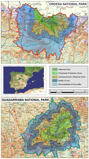
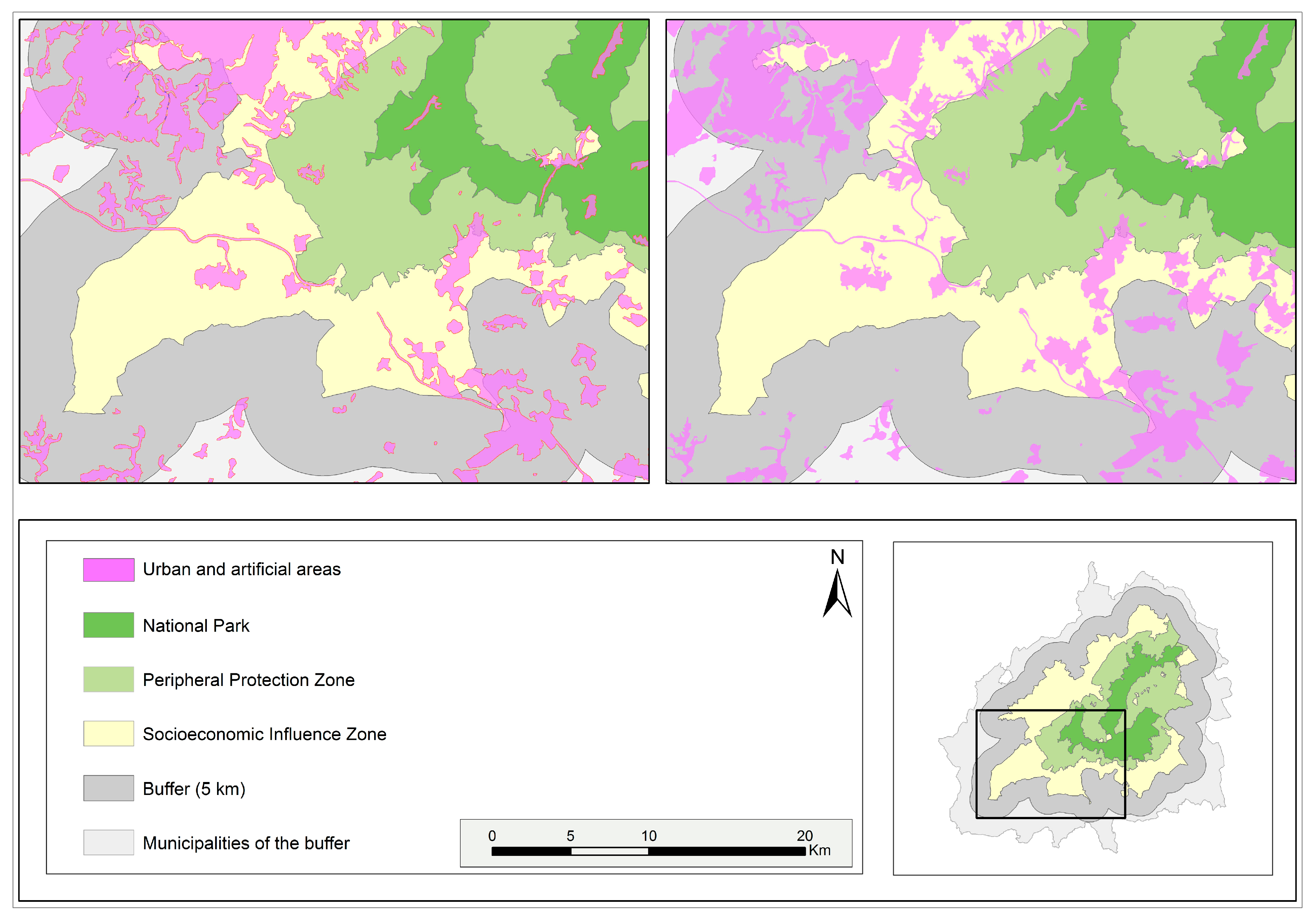
2.1. Study Areas
2.2. Materials
2.3. Methods
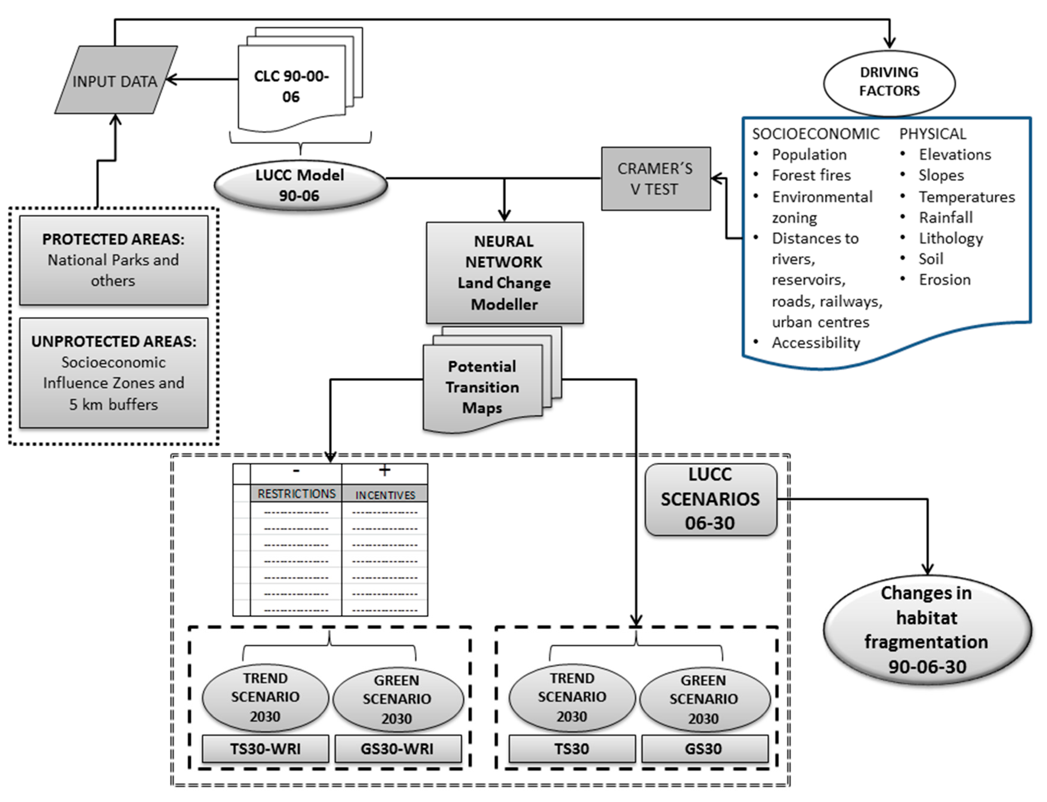
2.3.1. Land Use Changes between 1990 and 2006
2.3.2. Simulated Scenarios of Change in 2030
2.3.3. Fragmentation of Habitats of Interest
3. Results
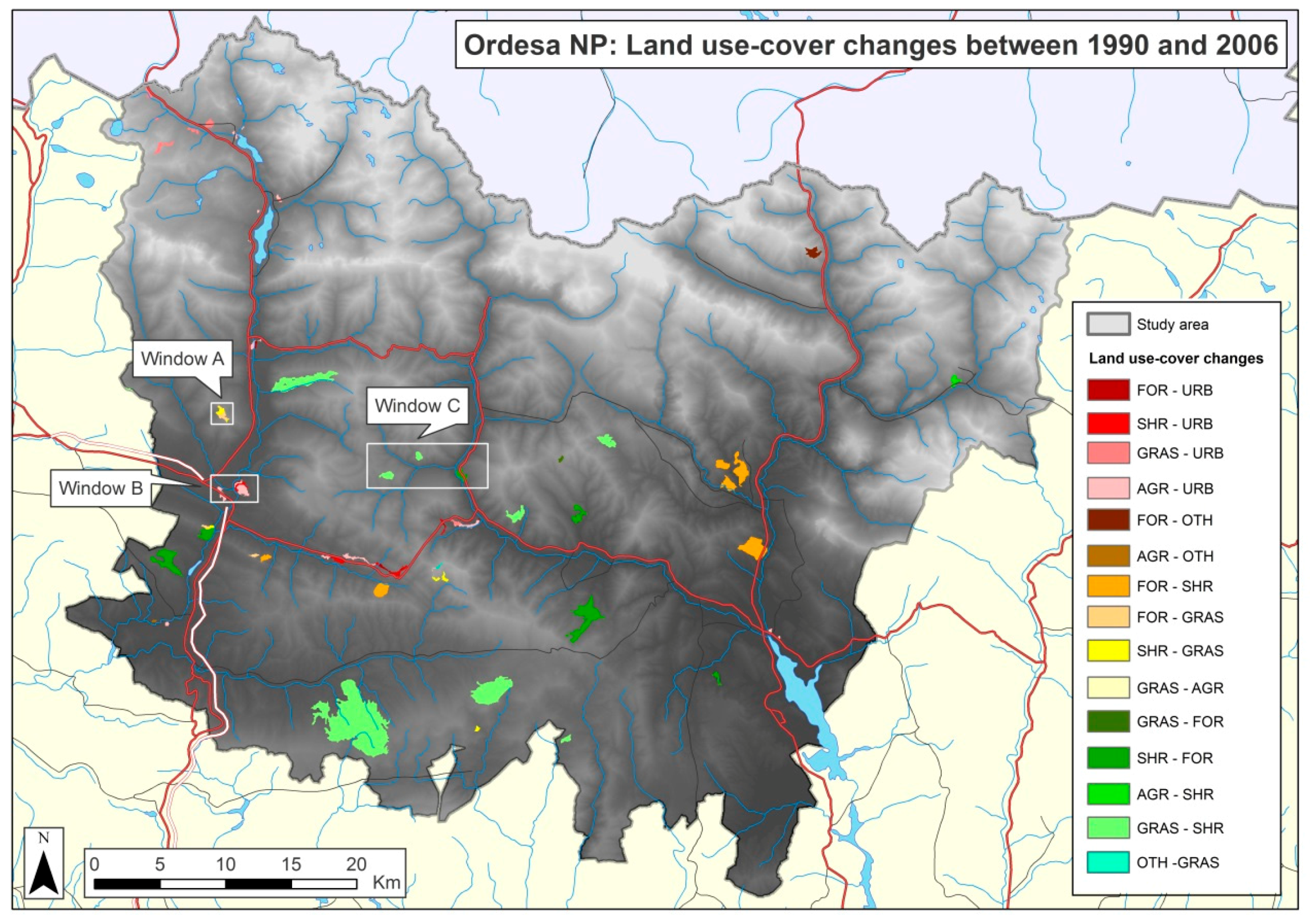
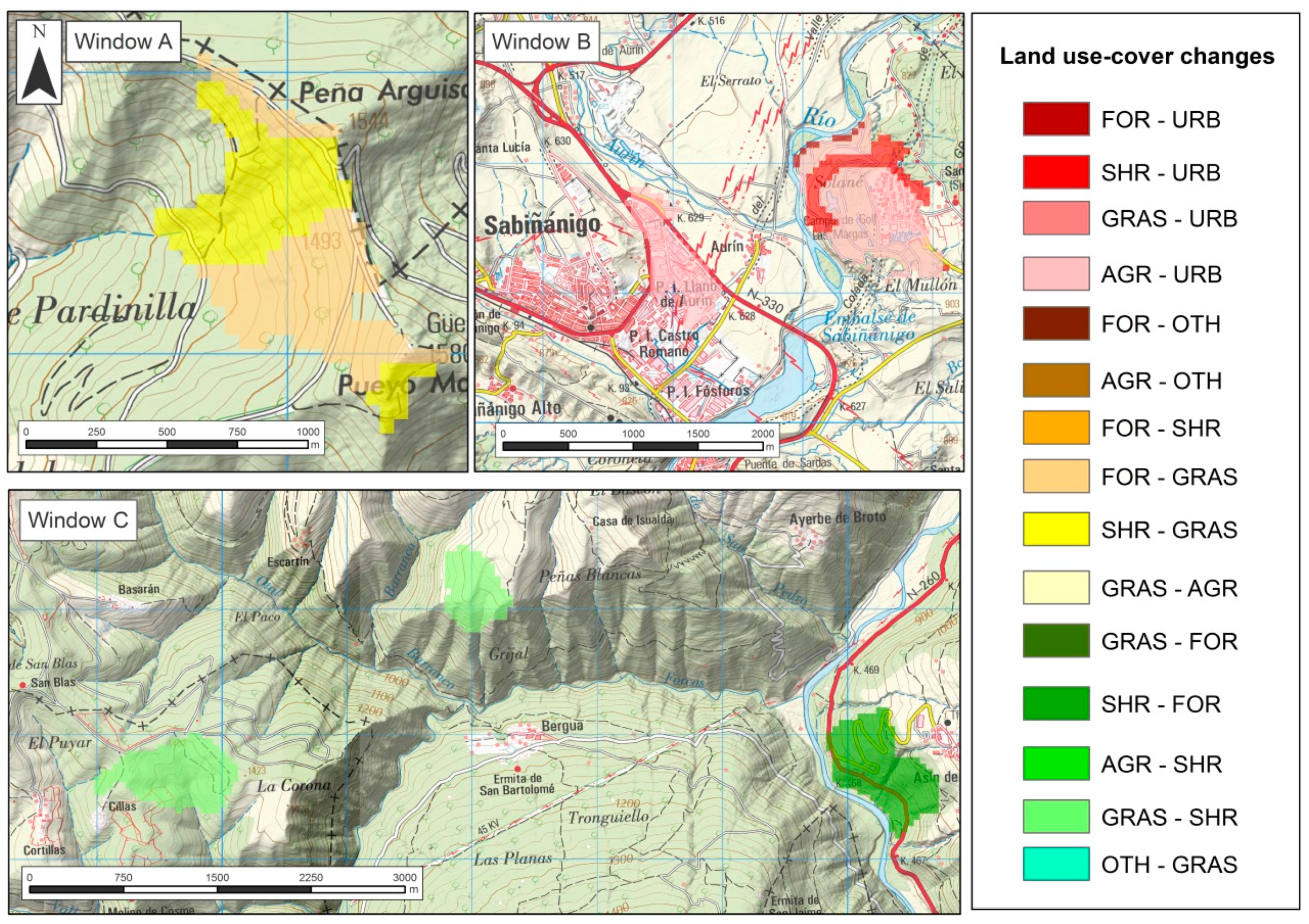
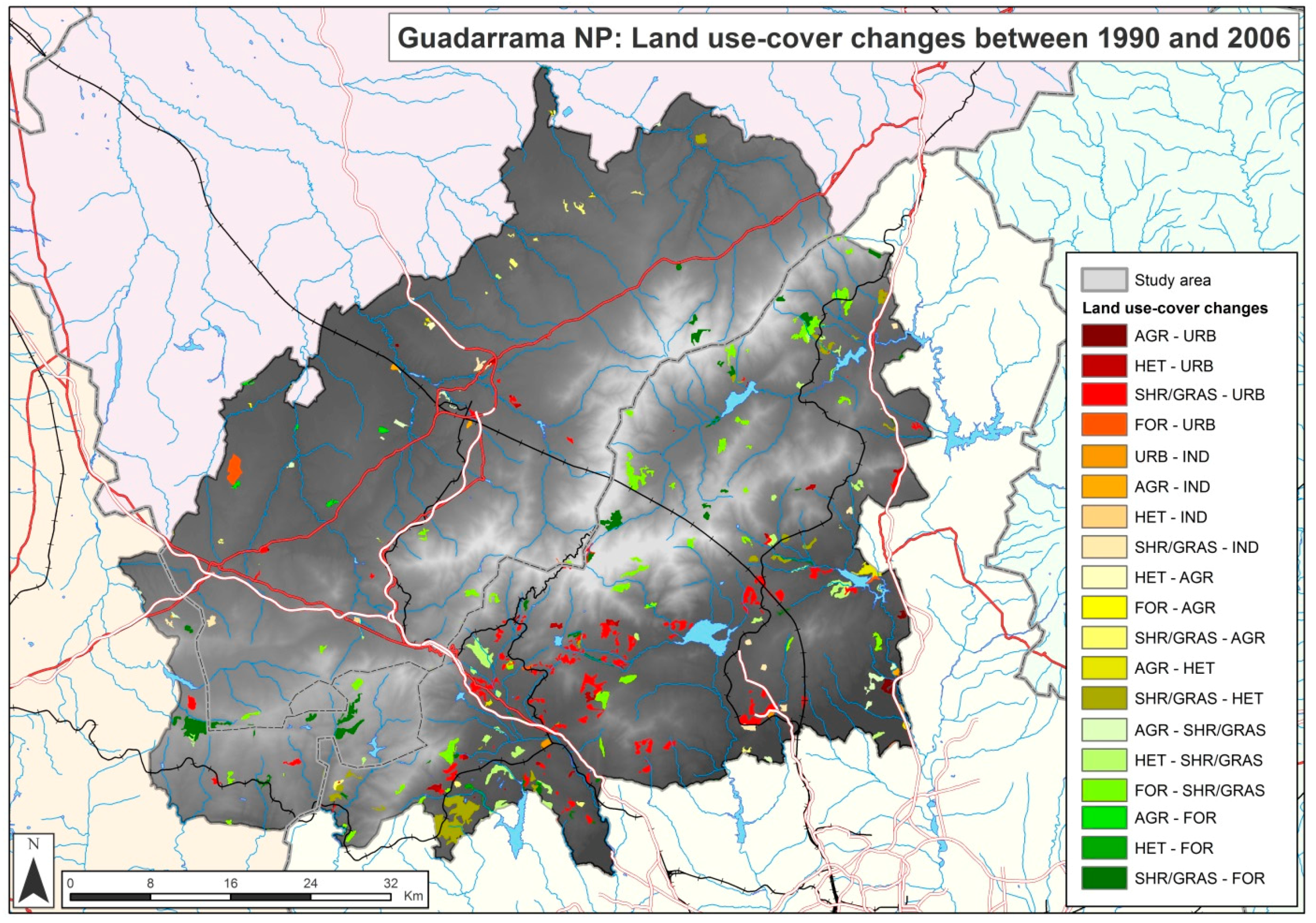
3.1. Land Use Changes between 1990 and 2006
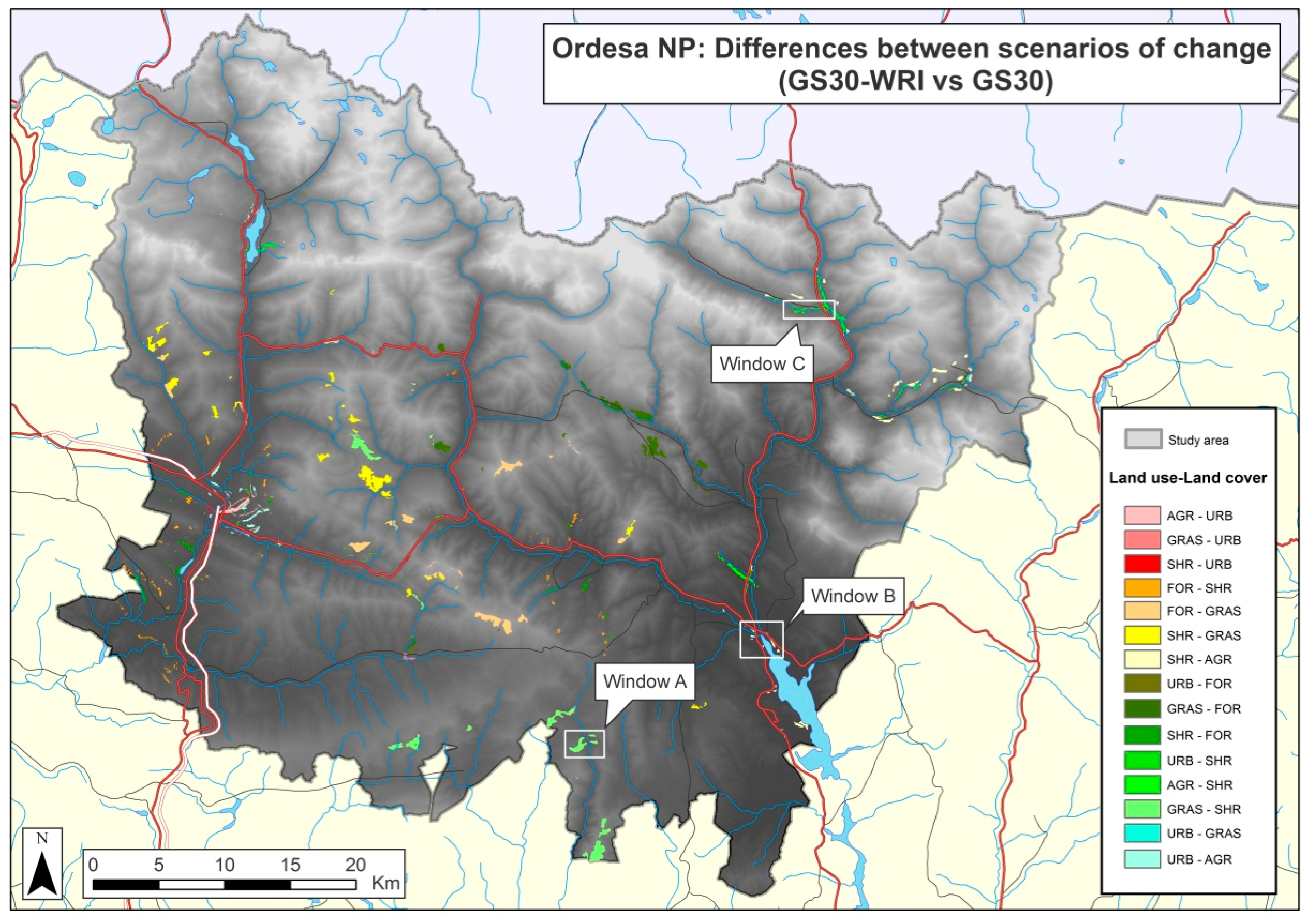
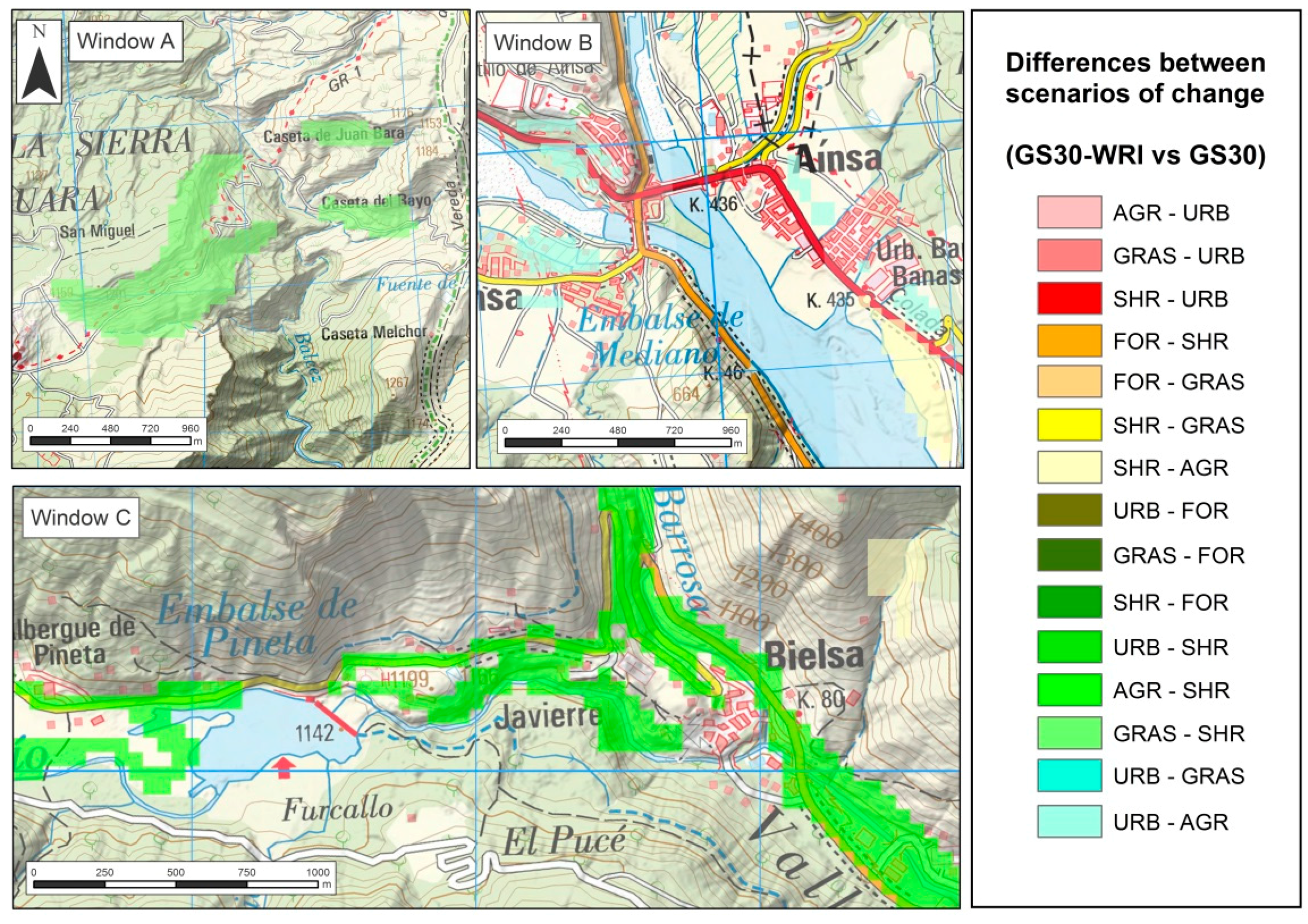
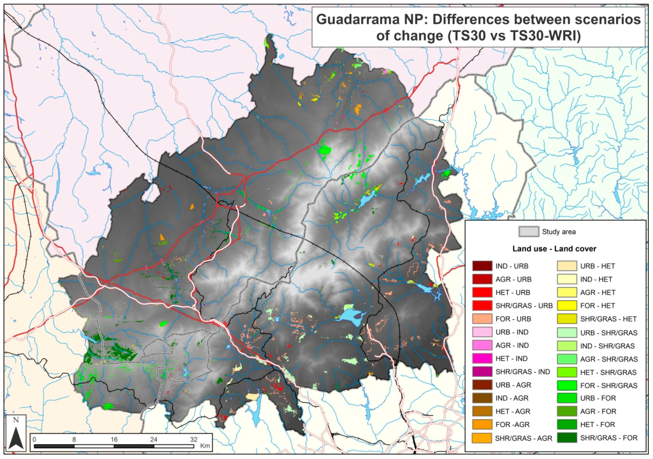
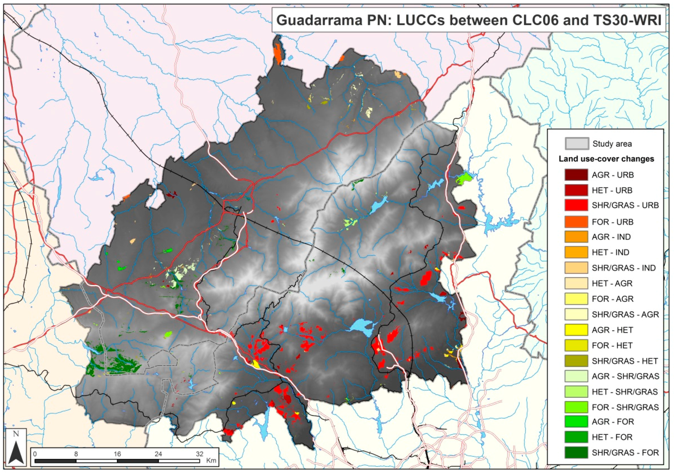
3.2. Simulated Scenarios of Change in 2030
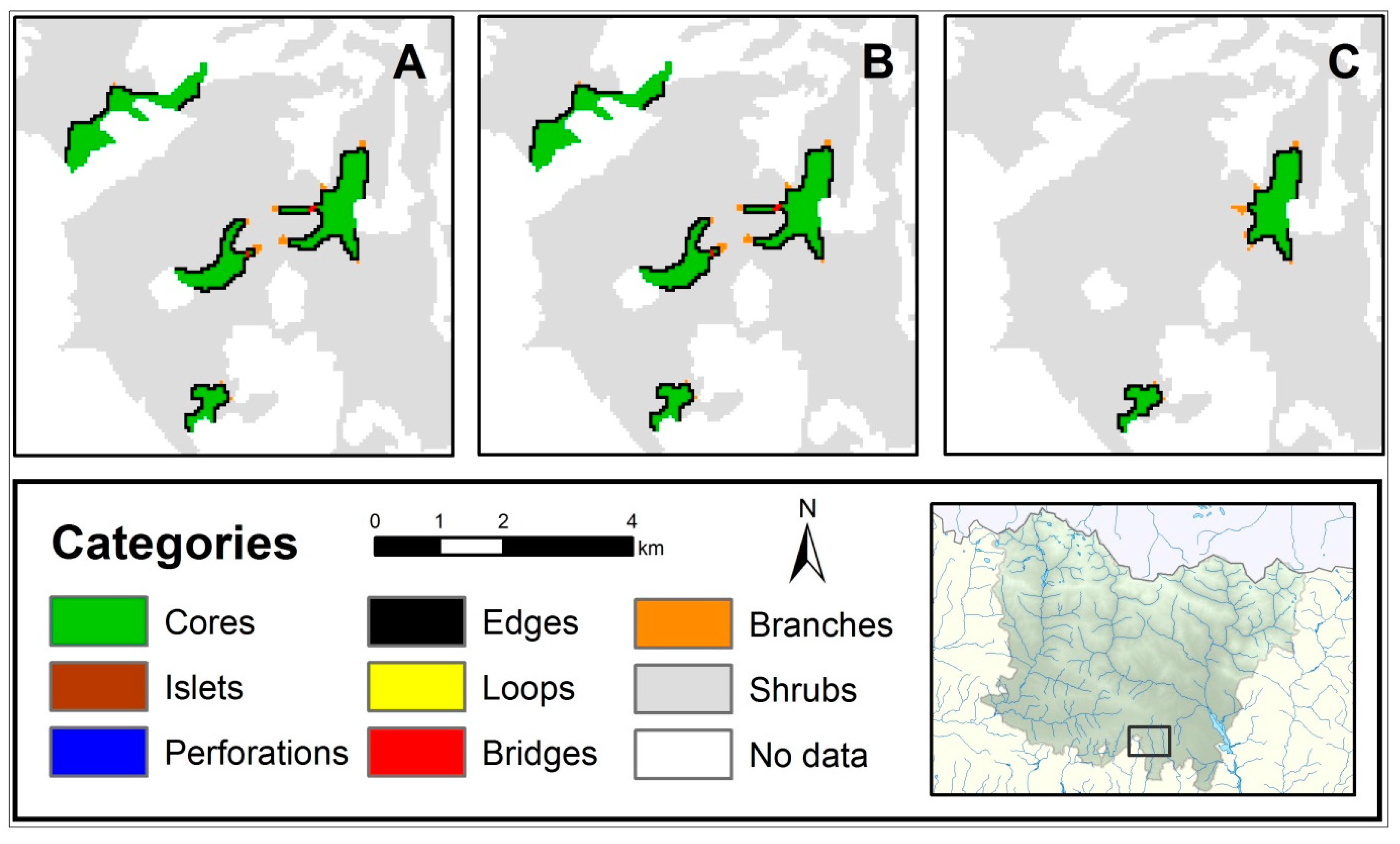
3.3. Fragmentation of Habitats of Interest
4. Discussion
5. Conclusions
Acknowledgments
Author Contributions
Conflicts of Interest
Appendix A

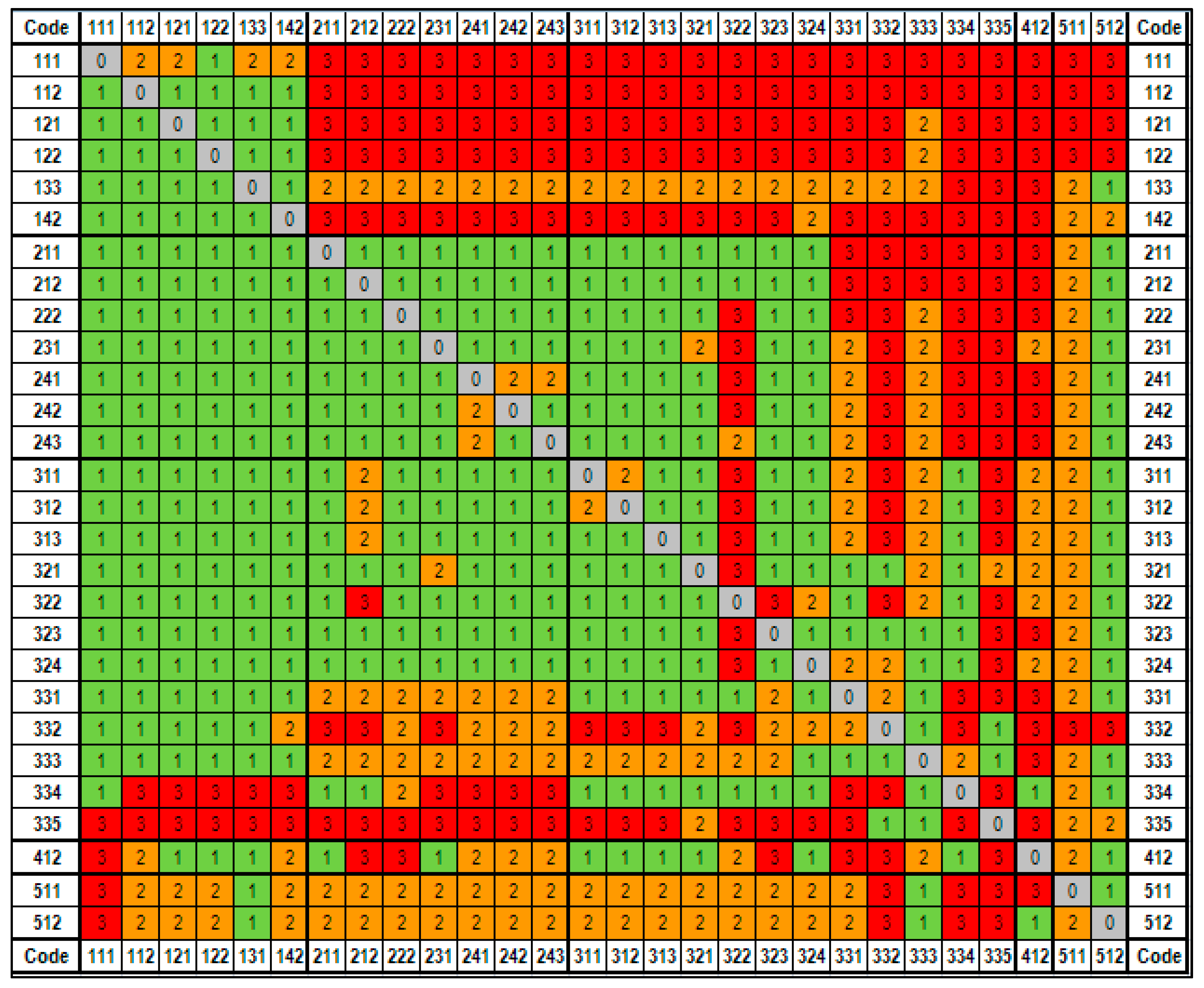
| Ordesa NP | CLC Classes, Level 3 | Guadarrama NP |
|---|---|---|
| Urban areas (URB) | 111 Continuous urban fabric | Urban areas (URB) |
| 112 Discontinuous urban fabric | ||
| 121 Industrial or commercial units | Industrial areas (IND) | |
| 122 Road and rail networks and associated land | Urban areas (URB) | |
| 123 Port areas | ||
| 124 Airports | ||
| 131 Mineral extraction sites | ||
| 132 Dump sites | ||
| 133 Construction sites | ||
| 141 Green urban areas | ||
| 142 Sport and leisure facilities | ||
| Agricultural areas (AGR) | 211 Non-irrigated arable land | Arable land and permanent crops (AGR) |
| 212 Permanently irrigated land | ||
| 213 Rice fields | ||
| 221 Vineyards | ||
| 222 Fruit trees and berry plantations | ||
| 223 Olive groves | ||
| 231 Pastures | Heterogeneous agricultural areas (HET) | |
| 241 Annual crops associated with permanent crops | ||
| 242 Complex cultivation patterns | ||
| 243 Land principally occupied by agriculture, with significant areas of natural vegetation | ||
| 244 Agro-forestry areas | ||
| Forests (FOR) | 311 Broadleaved forests | Forests (FOR) |
| 312 Coniferous forests | ||
| 313 Mixed forests | ||
| Grasslands (GRAS) | 321 Natural grasslands | Shrubs and grasslands (SHR-GRAS) |
| Shrubs (SHR) | 322 Moors and heathland | |
| 323 Sclerophyllous vegetation | ||
| 324 Transitional woodland-scrub | ||
| Others (OTH) | 331 Beaches, dunes, sands | Others (OTH) |
| 332 Bare rocks | ||
| 333 Sparsely vegetated areas | ||
| 334 Burnt areas | ||
| 335 Glaciers and perpetual snow | ||
| 411 Inland marshes | ||
| 412 Peat bogs | ||
| 421 Salt marshes | ||
| 422 Salines | ||
| 423 Intertidal flats | ||
| 511 Water courses | ||
| 512 Water bodies | ||
| 521 Coastal lagoons | ||
| 522 Estuaries | ||
| 523 Sea and ocean |
| (a) | |||
| Regulations | Zone | Restrictions | Incentives |
| Management plan for the Ordesa NP | NP and PPZ | Any transition from FOR or GRAS. Any transition to URB or AGR. | |
| SIZ | Any transition from GRAS | From SHR to GRAS | |
| Management plan for the Sierra y Cañones de Guara Regional Park | Between 1000 and 1600 masl. | Any transition from GRAS | From SHR to GRAS |
| Management plan for Posets Maladeta Regional Park | Between 1000 and 1600 masl. | Any transition from GRAS | From SHR to GRAS |
| Protection plan for the Natural Monument of the Pyrenean Glaciers | Any LUCC | ||
| Act 1/2001 on water | 100 m. restricted zone | Any LUCC | |
| Act 39/2003 on the railway sector | 70 m. from the outside edges of levelled ground | Any LUCC | |
| Act 8/1998 on roads in Aragon | 50 m. on both sides of motorways and highways; 18 m. on conventional roads | Any LUCC | |
| Act 21/2015 on forests | Burnt areas | From OTH to URB or AGR | |
| Landscape map of the district of Sobrabe [73] | Town of Aínsa | From AGR to URB | |
| (b) | |||
| Regulation | Zone | Restrictions | Incentives |
| Natural resource plan for the Guadarrama NP (region of Madrid) | Reserve | URB, IND, AGR, HET, SHR-GRAS | FOR |
| Maximum protection | URB, IND, AGR, HET, SHR-GRAS | ||
| Organised use of natural resources | URB, IND, AGR, HET, SHR-GRAS | ||
| Conservation and maintenance of traditional uses | URB, IND, AGR, HET, SHR-GRAS | HET | |
| Traditional settlements and special areas | URB, IND, AGR, HET, SHR-GRAS | ||
| Transition zones | SHR-GRAS | URB-IND | |
| Abantos protected landscape | URB-IND | ||
| Natural resource plan for the Guadarrama NP (region of Castilla y León) | Special plan | URB, IND, AGR, HET, FOR, SHR-GRAS | |
| Compatible use A | AGR, HET, FOR | ||
| General use | URB, IND | ||
| Limited use (common, peaks and special interest) | URB, IND, AGR, HET, SHR-GRAS | FOR | |
| Management plan for the summit, cirque and lagoons of Peñalara Regional Park | Maximum reserve | URB, IND | FOR |
| Special protection | URB, IND | FOR | |
| Educational interest | URB, IND | FOR | |
| Buffer and preservation | URB, IND | FOR | |
| Forest and cattle | URB, IND, AGR, SHR-GRAS | FOR | |
| Recreational use | URB, IND, HET | FOR | |
| Special use | URB, IND, AGR, HET, FOR, SHR-GRAS | FOR | |
| Management plan for the Cuenca Alta del Manzanares Regional Park | Natural reserve | URB, IND | HET, SHR-GRAS |
| Agricultural District park (protection, production and regeneration) | URB, IND | HET, SHR-GRAS | |
| Urban planning areas and transition | HET, SHR-GRAS | ||
| Management plan for the Cuenca del Río Manzanares SAC | FOR | ||
| Management plan for the River Guadarrama Regional Park | Maximum protection | URB, IND and from FOR to HET | FOR |
| Protection and improvement | URB, IND and from FOR to HET | ||
| Countryside | URB, IND and from FOR to HET | ||
| Management plan for the Cuenca del Río Guadalix SAC | FOR | ||
| Management plan for the Cuenca del Río Lozoya y Sierra Norte SAC | SHR-GRAS | ||
| Management plan for the Cuenca de los Ríos Alberche y Cofio SAC-SPA | Priority conservation A and B | URB, IND, AGR and from FOR to HET | FOR |
| General use | FOR | ||
| Management plan for Campo Azálvaro y Pinares de Peguerinos SAC-SPA | HET, FOR, SHR-GRAS | ||
| Management plan for Encinares de los Ríos Adaja y Voltoya SAC-SPA | HET, SHR-GRAS | ||
| Management plan for Sabinares de Somosierra SAC | HET, SHR-GRAS | ||
| Management plan for Lagunas de Cantalejo SAC-SPA | FOR | ||
| Management plan for Valles del Voltoya y Zorita SAC-SPA | FOR | ||
| Management plan for Pinares del bajo Alberche SAC-SPA | FOR | ||
| Act 21/2015 on forests | Burned areas | From OTH to URB or AGR | |
| Act 16/1995 on forests and nature protection in Madrid | Public utility forests | From FOR to HET | |
| Act 1/2001 on water | 100 m. restricted zone | Any LUCC | |
| Act 7/1990 on protection of reservoirs and wetlands in Madrid | 50 m. peripheral zone | URB, IND, AGR, HET, SHR-GRAS | |
| Act 39/2003 on the railway sector | 70 m. from the outside edges of levelled land | Any LUCC | |
| Act 3/1991 on roads in Madrid | 50 m. on both sides of motorways and highways; 25 m. on conventional roads | Any LUCC | |
| Act 2/1990 on roads in Castilla y León | 25 m. on both sides of motorways and highways; 8 m. on conventional roads | Any LUCC | |
| (a) | |||||||
| Driving Factors | URB | AGR | GRAS | SHR | FOR | OTH | Overall |
| Altitudes | 0.0621 | 0.3648 | 0.4757 | 0.2263 | 0.4515 | 0.7075 | 0.4247 |
| Slopes | 0.0000 | 0.0811 | 0.2072 | 0.0850 | 0.4150 | 0.1436 | 0.2081 |
| Temperatures | 0.0000 | 0.0960 | 0.4259 | 0.4738 | 0.3285 | 0.2444 | 0.3795 |
| Precipitation | 0.0000 | 0.0446 | 0.1684 | 0.2485 | 0.2006 | 0.2404 | 0.2090 |
| Ranker | 0.0000 | 0.0081 | 0.1070 | 0.0003 | 0.0427 | 0.0568 | 0.0975 |
| Rendzina | 0.0000 | 0.0229 | 0.0232 | 0.0845 | 0.0862 | 0.0437 | 0.0508 |
| Calcaric Fluvisol | 0.0000 | 0.0550 | 0.0206 | 0.0673 | 0.1909 | 0.0107 | 0.0845 |
| Dystrict Lithosol | 0.0000 | 0.0108 | 0.0595 | 0.0471 | 0.0403 | 0.0510 | 0.0584 |
| Calcaric Lithosol | 0.0000 | 0.0101 | 0.0543 | 0.0641 | 0.0224 | 0.0469 | 0.0401 |
| Chromic Vertisol | 0.0000 | 0.0107 | 0.0219 | 0.0193 | 0.0091 | 0.0230 | 0.0149 |
| Calcaric Cambisol | 0.0000 | 0.0117 | 0.0993 | 0.1640 | 0.0906 | 0.0136 | 0.1201 |
| Humic Cambisol | 0.0000 | 0.0024 | 0.1096 | 0.1612 | 0.0449 | 0.0888 | 0.0937 |
| Forest fires 86-05 | 0.0000 | 0.0060 | 0.0568 | 0.0288 | 0.0276 | 0.1515 | 0.0620 |
| Population density 91-11 | 0.0000 | 0.0394 | 0.2271 | 0.2674 | 0.1739 | 0.2236 | 0.1904 |
| Distance to roads | 0.0000 | 0.1104 | 0.2472 | 0.2620 | 0.3484 | 0.1066 | 0.2310 |
| Distance to reservoirs | 0.0000 | 0.0649 | 0.1879 | 0.0942 | 0.1679 | 0.1258 | 0.1367 |
| Distance to rivers | 0.0000 | 0.0327 | 0.1014 | 0.0914 | 0.1630 | 0.0395 | 0.1001 |
| Accesibility to Huesca | 0.1527 | 0.2891 | 0.2415 | 0.1429 | 0.2693 | 0.4076 | 0.2639 |
| Accesibility to Sabiñánigo | 0.0000 | 0.1348 | 0.2671 | 0.2089 | 0.3148 | 0.1099 | 0.2256 |
| Accesibility to railway stations | 0.0000 | 0.1287 | 0.2713 | 0.2117 | 0.3089 | 0.1029 | 0.2247 |
| (b) | |||||||
| Driving Factors | URB | IND | AGR | HET | FOR | SHR-GRAS | Overall |
| Slopes | 0.0000 | 0.1015 | 0.0309 | 0.3619 | 0.1693 | 0.3642 | 0.1713 |
| Sedimentary rocks | 0.0000 | 0.0534 | 0.0081 | 0.5988 | 0.0174 | 0.0919 | 0.1283 |
| Granite rocks | 0.0000 | 0.1642 | 0.0224 | 0.2045 | 0.0222 | 0.0782 | 0.0819 |
| Igneous rocks | 0.0000 | 0.0156 | 0.0123 | 0.0398 | 0.0105 | 0.0266 | 0.0175 |
| Metamorphic rocks | 0.0000 | 0.0808 | 0.0281 | 0.3430 | 0.0292 | 0.1559 | 0.1062 |
| Distance to reservoirs | 0.0000 | 0.1005 | 0.0465 | 0.5632 | 0.1178 | 0.1243 | 0.1587 |
| Distance to rivers | 0.0000 | 0.0315 | 0.0678 | 0.1614 | 0.0686 | 0.0529 | 0.0637 |
| Accesibility to roads | 0.0000 | 0.1600 | 0.0504 | 0.1749 | 0.1588 | 0.1981 | 0.1237 |
| Accesibility to Madrid | 0.2519 | 0.1797 | 0.2925 | 0.1346 | 0.1679 | 0.1684 | 0.1992 |
| (a) | ||||||
| T1/T2 | URB | AGR | GRAS | SHR | FOR | OTH |
| URB | 1.0000 | 0.0000 | 0.0000 | 0.0000 | 0.0000 | 0.0000 |
| AGR | 0.0001 | 0.9996 | 0.0000 | 0.0003 | 0.0000 | 0.0000 |
| GRAS | 0.0017 | 0.0000 | 0.9979 | 0.0003 | 0.0001 | 0.0000 |
| SHR | 0.0000 | 0.0000 | 0.0000 | 0.9998 | 0.0002 | 0.0000 |
| FOR | 0.0000 | 0.0000 | 0.0000 | 0.0002 | 0.9998 | 0.0000 |
| OTH | 0.0000 | 0.0000 | 0.0000 | 0.0000 | 0.0000 | 1.0000 |
| (b) | ||||||
| T1/T2 | URB | AGR | GRAS | SHR | FOR | OTH |
| URB | 1.0000 | 0.0000 | 0.0000 | 0.0000 | 0.0000 | 0.0000 |
| AGR | 0.0210 | 0.8590 | 0.0500 | 0.0400 | 0.0300 | 0.0000 |
| GRAS | 0.0030 | 0.0050 | 0.9470 | 0.0250 | 0.0200 | 0.0000 |
| SHR | 0.0050 | 0.0050 | 0.0000 | 0.9600 | 0.0300 | 0.0000 |
| FOR | 0.0000 | 0.0000 | 0.0000 | 0.0000 | 1.0000 | 0.0000 |
| OTH | 0.0000 | 0.0000 | 0.0000 | 0.0000 | 0.0000 | 1.0000 |
References
- Wandersee, S.M.; An, L.; López-Carr, D.; Yang, Y. Perception and decisions in modeling coupled human and natural systems: A case study from Fanjingshan National Nature Reserve, China. Ecol. Model. 2012, 229, 37–49. [Google Scholar] [CrossRef]
- Ruiz-Mallén, I.; Corbera, E.; Calvo-Boyero, D.; Reyes-García, D. Participatory scenarios to explore local adaptation to global change in biosphere reserves: Experiences from Bolivia and Mexico. Environ. Sci. Policy 2015, 54, 398–408. [Google Scholar] [CrossRef]
- Martínez-Fernández, J.; Ruiz-Benito, P.; Zavala, M.A. Recent land cover changes in Spain across biogeographical regions and protection levels: Implications for conservation policies. Land Use Policy 2015, 44, 62–75. [Google Scholar] [CrossRef]
- Food and Agriculture Organization of the United Nations. Global Forest Resources Assessment 2010; FAO: Rome, Italy, 2010. [Google Scholar]
- Saraswati, G. Development Directives In Disaster-Prone Areas Based on Identification Level Vulnerability Using Geographical Information System Applications in Bogor Regency. Procedia Soc. Behav. Sci. 2014, 135, 112–117. [Google Scholar] [CrossRef]
- Chuvieco, E.; Martínez, S.; Román, M.V.; Hantson, S.; Pettinari, M.L. Integration of ecological and socio-economic factors to assess global vulnerability to wildfire. Glob. Ecol. Biogeogr. 2014, 23, 245–258. [Google Scholar] [CrossRef]
- Dantas de Paula, M.; Groeneveld, J.; Huth, A. Tropical forest degradation and recovery in fragmented landscapes. Simulating changes in tree community, forest hidrology and carbon balance. Glob. Ecol. Conserv. 2015, 3, 664–677. [Google Scholar] [CrossRef]
- Lei, C.; Lin, Z.; Zhang, Q. The spreading front of invasive species in favorable habitat or unfavorable habitat. J. Differ. Equ. 2014, 257, 145–166. [Google Scholar] [CrossRef]
- McDonald, R.I. Implications of Urbanization for Conservation and Biodiversity Protection. In Encyclopedia of Biodiversity, 2nd ed.; Levin, S.A., Ed.; Academic Press: Amsterdam, The Netherlands, 2013; pp. 231–244. [Google Scholar]
- López Lambas, M.E.; Ricci, S. Planning and management of mobility in natural protected areas. Procedia Soc. Behav. Sci. 2014, 162, 320–329. [Google Scholar] [CrossRef]
- UNEP-World Conservation Monitoring Centre. World Database on Protected Areas. 2012. Available online: https://www.protectedplanet.net/c/world-database-on-protected-areas (accessed on 29 September 2017).
- Venter, O.; Fuller, R.A.; Segan, D.B.; Carwardine, J.; Brooks, T.; Butchart, S.H.M.; Di Marco, M.; Iwamura, T.; Joseph, L.; O’Grady, D.; et al. Targeting Global Protected Area Expansion for Imperiled Biodiversity. PLoS Biol. 2014, 12, e1001891. [Google Scholar] [CrossRef] [PubMed]
- Juffe-Bignoli, D.; Burgess, N.D.; Bingham, H.; Belle, E.M.S.; de Lima, M.G.; Deguignet, M.; Bertzky, B.; Milam, A.N.; Martinez-Lopez, J.; Lewis, E.; et al. Protected Planet Report 2014; UNEP-WCMC: Cambridge, UK, 2014. [Google Scholar]
- Convention on Biological Diversity. COP 10 Decision X/2: X/2. Strategic Plan for Biodiversity 2011–2020. Available online: https://www.cbd.int/decision/cop/?id=12268 (accessed on 12 September 2017).
- Deguignet, M.; Juffe-Bignoli, D.; Harrison, J.; MacSharry, B.; Burgess, N.; Kingston, N. United Nations List of Protected Areas; UNEP-WCMC: Cambridge, UK, 2014. [Google Scholar]
- EUROPARC-España. Anuario 2013 del Estado de las Áreas Protegidas en España; Fundación Fernando González Bernáldez: Madrid, Spain, 2014. [Google Scholar]
- Dudley, N. Guidelines for Applying Protected Area Management Categories; IUCN: Gland, Switzerland, 2008. [Google Scholar]
- Spanish Government. Ley de 7 de Diciembre de 1916, de Parques Nacionales de España. Gaceta de Madrid. 1916. Available online: https://www.boe.es/datos/pdfs/BOE/1916/343/A00575-00575.pdf (accessed on 19 September 2017).
- Spanish Government. Ley 30/2014, de 3 de Diciembre, de Parques Nacionales. Boletín Oficial del Estado. 2014. Available online: https://www.boe.es/boe/dias/2014/12/04/pdfs/BOE-A-2014-12588.pdf (accessed on 19 September 2017).
- Lambin, E.F.; Turner, B.L.; Geist, H.J.; Agbola, S.B.; Angelsen, A.; Folke, C.; Bruce, J.W.; Coomes, O.T.; Dirzo, R.; George, P.S.; et al. The causes of land-use and land-cover change: Moving beyond the myths. Glob. Environ. Chang. 2001, 11, 261–269. [Google Scholar] [CrossRef]
- Romero-Calcerrada, R.; Perry, G.L.W. The role of land abandonment in landscape dynamics in the SPA Encinares del río Alberche y Cofio, Central Spain, 1984–1999. Landsc. Urban Plan. 2004, 66, 217–232. [Google Scholar] [CrossRef]
- Viedma, O.; Moity, N.; Moreno, J.M. Changes in landscape fire-hazard during the second half of the 20th century: Agriculture abandonment and the changing role of driving factors. Agric. Ecosyst. Environ. 2015, 207, 126–140. [Google Scholar] [CrossRef]
- Lambin, E.F.; Geist, H.J. Land-Use and Land-Cover Change. Local Processes and Global Impacts; Springer-Verlag: Berlin, Germany, 2006. [Google Scholar]
- Dong, J.; Xiao, X.; Sheldon, S.; Biradar, C.; Duong, N.; Hazarika, M. A comparison of forest cover maps in mainland Southeast Asia from multiple sources: PALSAR, MERIS, MODIS and FRA. Remote Sens. Environ. 2012, 127, 60–73. [Google Scholar] [CrossRef]
- Yu, W.; Zhou, W.; Qiana, Y.; Yan, J. A new approach for land cover classification and change analysis: Integrating backdating and an object-based method. Remote Sens. Environ. 2016, 177, 37–47. [Google Scholar] [CrossRef]
- Hewitt, R.; Pera, F.; Escobar, F. Cambios recientes en la ocupación del suelo de los parques nacionales. Cuadernos Geográficos 2016, 55, 46–84. [Google Scholar]
- Rodríguez-Rodríguez, D.; Martínez-Vega, J. What should be evaluated from a manager’s perspective? Developing a salient protected area effectiveness evaluation system for managers and scientists in Spain. Ecol. Indic. 2016, 64, 289–296. [Google Scholar] [CrossRef]
- Spracklen, B.D.; Kalamandeen, M.; Galbraith, D.; Gloor, E.; Spracklen, D.V. A global analysis of deforestation in moist tropical forest protected areas. PLoS ONE 2015, 10, e0143886. [Google Scholar] [CrossRef] [PubMed]
- Mcdonald, R.I.; Forman, R.T.T.; Kareiva, P.; Neugarten, R.; Salzer, D.; Fisher, J. Urban effects, distance, and protected areas in an urbanizing world. Landsc. Urban Plan. 2009, 93, 63–75. [Google Scholar] [CrossRef]
- Radeloff, V.C.; Stewart, S.I.; Hawbaker, T.J.; Gimmi, U.; Pidgeon, A.M.; Flather, C.H.; Hammer, R.B.; Helmers, D.P. Housing growth in and near United States protected areas limits their conservation value. PNAS 2010, 107, 940–945. [Google Scholar] [CrossRef] [PubMed]
- Gallardo, M.; Martinez-Vega, J. Future Land Use Change Dynamics in Natural Protected Areas—Madrid Region Case Study. In Proceedings of the 3rd International Conference on Geographical Information Systems Theory, Applications and Management (GISTAM 2017), Porto, Portugal, 27–28 April 2017; Ragia, L., Rocha, J.G., Laurini, R., Eds.; SCITEPRESS–Science and Technology Publications: Setúbal, Portugal, 2017; pp. 370–377. [Google Scholar]
- Gurrutxaga, M.; Rubio, L.; Saura, S. Key connectors in protected forest area networks and the impact of highways: A transnational case study from the Cantabrian Range to the Western Alps (SW Europe). Landsc. Urban Plan. 2011, 101, 310–320. [Google Scholar] [CrossRef]
- Pascual-Aguilar, J.; Andreu, V.; Gimeno-García, E.; Picó, Y. Current anthropogenic pressures on agro-ecological protected coastal wetlands. Sci. Total Environ. 2015, 503–504, 190–199. [Google Scholar] [CrossRef] [PubMed]
- Gartzia, M.; Pérez-Cabello, F.; Bueno, C.B.; Alados, C.L. Physiognomic and physiologic changes in mountain grasslands in response to environmental and anthropogenic factors. Appl. Geogr. 2016, 66, 1–11. [Google Scholar] [CrossRef]
- Alados, C.L.; Errea, P.; Gartzia, M.; Saiz, H.; Escós, J. Positive and Negative Feedbacks and Free-Scale Pattern Distribution in Rural-Population Dynamics. PLoS ONE 2014, 9, e114561. [Google Scholar] [CrossRef] [PubMed]
- Gartzia, M.; Alados, C.L.; Pérez-Cabello, F. Assessment of the effects of biophysical and anthropogenic factors on woody plant encroachment in dense and sparse mountain grasslands based on remote sensing data. Prog. Phys. Geogr. 2014, 38, 201–217. [Google Scholar] [CrossRef]
- Gómez-Limón, F.J.; de Lucio, J.V. Recreational activities and loss of diversity in grasslands in Alta Manzanares Natural Park, Spain. Biol. Conserv. 1995, 74, 99–105. [Google Scholar] [CrossRef]
- Palomino, D.; Carrascal, L.M. Urban influence on birds at regional scale: A case study with the avifauna of northern Madrid province. Landsc. Urban Plan. 2006, 77, 276–290. [Google Scholar] [CrossRef]
- Palomino, D.; Carrascal, L.M. Habitat associations of a raptor community in a mosaic landscape of Central Spain under urban development. Landsc. Urban Plan. 2007, 83, 268–274. [Google Scholar] [CrossRef]
- García-Ureta, A. Wilderness protection in Spain. In Wilderness Protection in Europe: The Role of International European and National Law; Bastmeijer, K., Ed.; Cambridge University Press: Cambridge, UK, 2016; pp. 455–481. [Google Scholar]
- Verburg, P.H.; Overmars, K.P. Combining top-down and bottom-up dynamics in land use modeling: Exploring the future of abandoned farmlands in Europe with the Dyna-CLUE model. Landsc. Ecol. 2009, 24, 1167–1181. [Google Scholar] [CrossRef]
- Pontius, R.G., Jr.; Huffaker, D.; Denman, K. Useful techniques of validation for spatially explicit land-change models. Ecol. Model. 2004, 179, 445–461. [Google Scholar] [CrossRef]
- Rodríguez Eraso, N.; Armenteras-Pascual, D.; Retana Alumbreros, J. Land use and land cover change in the Colombian Andes: Dynamics and future scenarios. J. Land Use Sci. 2013, 8, 154–174. [Google Scholar] [CrossRef]
- Soares-Filho, B.S.; Pennachin, C.L.; Cerqueria, G. DINAMICA—A stochastic cellular automata model designed to simulate the landscape dynamics in an Amazonian colonization frontier. Ecol. Model. 2002, 154, 217–235. [Google Scholar] [CrossRef]
- Walsh, S.J.; Entwisle, B.; Rindfuss, R.R.; Page, P.H. Spatial simulation modelling of land use/land cover change scenarios in northeastern Thailand: A cellular automata approach. J. Land Use Sci. 2006, 1, 5–28. [Google Scholar] [CrossRef]
- Mancosu, E.; Gago-Silva, A.; Barbosa, A.; de Bono, A.; Ivanov, E.; Lehmann, A.; Fons, J. Future land-use change scenarios for the Black Sea catchment. Environ. Sci. Policy 2015, 46, 26–36. [Google Scholar] [CrossRef]
- Pontius, R.G., Jr.; Boersma, W.; Castella, J.-C.; Clarke, K.; De Nijs, T.C.M.; Dietzel, C.; Duan, Z.; Fotsing, E.; Goldstein, N.; Kok, K.; et al. Comparing the input, output and validation maps for several models of land change. Ann. Reg. Sci. 2008, 42, 11–37. [Google Scholar] [CrossRef]
- Nogueira-Terra, T.; Ferreira dos Santos, R.; Cortijo, D. Land use changes in protected areas and their future: The legal effectiveness of landscape protection. Land Use Policy 2014, 38, 378–387. [Google Scholar] [CrossRef]
- Díaz-Pacheco, J.; Hewitt, R. Modelado del cambio de usos del suelo urbano a través de Redes Neuronales Artificiales. Comparación con dos aplicaciones de software. Geofocus 2013, 14, 1–22. [Google Scholar]
- Gallardo, M.; Gómez, I.; Vilar, L.; Martínez-Vega, J.; Martín, M.P. Impacts of future land use/land cover on wildfire occurrence in the Madrid region. Reg. Environ. Chang. 2016, 16, 1047–1061. [Google Scholar] [CrossRef]
- Spanish Government. Declaración del Parque Nacional del Valle de Ordesa. Gaceta de Madrid. 1918. Available online: http://www.mapama.gob.es/es/red-parques-nacionales/nuestros-parques/ordesa/_creacion_tcm7-257426.pdf (accessed on 19 September 2017).
- Instituto Nacional de Estadística (INE). INEbase. Demografía y Población. Padrón. Población por Municipios. Cifras Oficiales de Población de los Municipios Españoles: Revisión del Padrón Municipal. Cifras Oficiales de Población Resultantes de la Revisión del Padrón Municipal a 1 de enero. 2017. Available online: http://www.ine.es/dynt3/inebase/index.htm?padre=525 (accessed on 3 September 2017).
- Ministerio de Agricultura, Pesca, Alimentación y Medio Ambiente (MAPAMA). Memoria de la Red de Parques Nacionales. 2015. Available online: http://www.mapama.gob.es/es/red-parques-nacionales/divulgacion/memoria-2015_tcm7-454259.pdf (accessed on 3 September 2017).
- Spanish Government. Ley 7/2013, de 25 de junio, de declaración del Parque Nacional de la Sierra de Guadarrama. Boletín Oficial del Estado. 2013. Available online: https://www.boe.es/boe/dias/2013/06/26/pdfs/BOE-A-2013-6900.pdf (accessed on 19 September 2017).
- Ministerio de Agricultura, Pesca, Alimentación y Medio Ambiente (MAPAMA). Memoria de la Red de Parques Nacionales. 2014. Available online: http://www.mapama.gob.es/es/red-parques-nacionales/divulgacion/memoria-2014_tcm7-454256.pdf (accessed on 29 September 2017).
- Eastman, J.R. IDRISI Terrset Manual; Clark Labs-Clark University: Worcester, MA, USA, 2016. [Google Scholar]
- Map Comparison Kit 3, User Manual. Research Institute for Knowledge Systems. Available online: https://www.dropbox.com/s/aybrp1f7fwgv2nr/MCK_Manual_3_2_1.pdf (accessed on 30 October 2017).
- Soille, P.; Vogt, P. Morphological segmentation of binary patterns. Pattern Recognit. Lett. 2009, 30, 456–459. [Google Scholar] [CrossRef]
- Bossard, M.; Feranec, J.; Otahel, J. CORINE Land Cover Technical Guide—Addendum 2000; European Environment Agency: Copenhagen, Danmark, 2000. [Google Scholar]
- Martinuzzi, S.; Radeloff, V.C.; Joppa, L.N.; Hamilton, C.M.; Helmers, D.P.; Plantinga, D.P.; Lewis, D.J. Scenarios of future land use change around United States’ protected areas. Biol. Conserv. 2015, 184, 446–455. [Google Scholar] [CrossRef]
- Catalá Mateo, R.; Bosque Sendra, J.; Plata Rocha, W. Análisis de posibles errores en la base de datos CORINE Land Cover (1990–2000) en la Comunidad de Madrid. Estud. Geogr. 2008, 49, 81–104. [Google Scholar]
- Díaz-Pacheco, J.; Gutiérrez, J. Exploring the limitations of CORINE Land Cover for monitoring urban land-use dynamics in metropolitan areas. J. Land Use Sci. 2013, 9, 243–259. [Google Scholar] [CrossRef]
- Centro Nacional de Información Geográfica (CNIG). Centro de Descargas. Available online: http://centrodedescargas.cnig.es/CentroDescargas/index.jsp (accessed on 29 September 2017).
- Stellmes, M.; Röder, A.; Udelhoven, T.; Hill, J. Mapping syndromes of land change in Spain with remote sensing time series, demographic and climatic data. Land Use Policy 2013, 30, 685–702. [Google Scholar] [CrossRef]
- Díaz-Pacheco, J. Ciudades, Autómatas Celulares y Sistemas Complejos: Evaluación de un Modelo Dinámico de Cambio de Usos de Suelo urbano de Madrid. Ph.D. Thesis, Universidad Complutense de Madrid, Madrid, Spain, 10 September 2015. [Google Scholar]
- Cramér, H. Mathematical Methods of Statistics; Princeton University Press: Princeton, NJ, USA, 1946. [Google Scholar]
- Pontius, R.G., Jr.; Millones, M. Death to Kappa: Birth of quantity disagreement and allocation disagreement for accuracy assessment. Int. J. Remote Sens. 2011, 32, 4407–4429. [Google Scholar] [CrossRef]
- Van Vliet, J.; Bregt, A.K.; Hagen-Zanker, A. Revisiting Kappa to account for change in the accuracy assessment of land-use change models. Ecol. Model. 2011, 222, 1367–1375. [Google Scholar] [CrossRef]
- Van Vliet, J.; Naus, N.; van Lammeren, R.J.; Bregt, A.K.; Hurkens, J.; van Delden, H. Measuring the neighbourhood effect to calibrate land use models. Comput. Environ. Urban 2013, 41, 55–64. [Google Scholar] [CrossRef]
- Opdam, P.; Verboom, J.; Pouwels, R. Landscape cohesion: An index for the conservation potential of landscapes for biodiversity. Landsc. Ecol. 2003, 18, 113–126. [Google Scholar] [CrossRef]
- Opdam, P.; Steingrover, E.; Rooij, S.V. Ecological networks: A spatial concept for multi-actor planning of sustainable landscapes. Landsc. Urban Plan. 2006, 75, 322–332. [Google Scholar] [CrossRef]
- Gómez, I.; Martín, M.P.; Salas, F.J.; Gallardo, M. Análisis del régimen histórico de incendios forestales en la Comunidad de Madrid (1985–2010) y su relación con los cambios de usos del suelo. In Proceedings of the 15th Congreso Nacional de Tecnologías de la Información Geográfica, Madrid, Spain, 19–21 September 2012; Martínez-Vega, J., Martín, M.P., Eds.; AGE: Madrid, Spain, 2012; pp. 71–82. [Google Scholar]
- Dolz, P.A.; Cáncer, L. Mapa de Paisaje de la Comarca de Sobrarbe. Mapa de Prospectiva del Paisaje; Gobierno de Aragón: Zaragoza, Spain, 2009. [Google Scholar]
- Hewitt, R.; van Delden, H.; Escobar, F. Participatory land use modelling, pathways to an integrated approach. Environ. Model. Softw. 2014, 52, 149–164. [Google Scholar] [CrossRef]
- IUCN. PANORAMA: Solutions for a Healthy Planet. 2017. Available online: https://www.iucn.org/theme/protected-areas/our-work/protected-area-solutions/panorama-solutions-healthy-planet (accessed on 12 September 2017).
- Valcarcel, N.; Villa, G.; Arozarena, A.; Garcia-Asensio, L.; Caballero, M.E.; Porcuna, A.; Domenech, E.; Peces, J.J. SIOSE, a Successful Test Bench Towards Harmonization and Integration of Land Cover/Use Information As Environmental Reference Data. Remote Sens. Spat. Inf. Sci. 2009, 37, 1159–1164. [Google Scholar]
- García-Álvarez, D.; Camacho Olmedo, M.T. Changes in the methodology used in the production of the Spanish CORINE: Uncertainty analysis of the new maps. Int. J. Appl. Earth Obs. 2017, 63, 55–67. [Google Scholar] [CrossRef]
- Ministerio de Agricultura, Pesca, Alimentación y Medio Ambiente (MAPAMA). Banco de Datos de la Naturaleza. Available online: http://sig.mapama.es/bdn/visor.html (accessed on 29 September 2017).
- Paegelow, M. Land Change Modeling Handling with Various Training Dates. In Proceedings of the 3rd International Conference on Geographical Information Systems Theory, Applications and Management (GISTAM 2017), Porto, Portugal, 27–28 April 2017; Ragia, L., Rocha, J.G., Laurini, R., Eds.; SCITEPRESS–Science and Technology Publications: Setúbal, Portugal, 2017; pp. 350–356. [Google Scholar]
- Candau, J. Calibrating a cellular automaton model of urban growth in a timely manner. In Proceedings of the 4th International Conference on Integrating GIS and Environmental Modeling (GIS/EM4), Banff, AB, Canada, 2–8 September 2000. [Google Scholar]
- Clarke, K. Improving SLEUTH Calibration with a Genetic Algorithm. In Proceedings of the 3rd International Conference on Geographical Information Systems Theory, Applications and Management (GISTAM 2017), Porto, Portugal, 27–28 April 2017; Ragia, L., Rocha, J.G., Laurini, R., Eds.; SCITEPRESS–Science and Technology Publications: Setúbal, Portugal, 2017; pp. 319–326. [Google Scholar]
- Metronamica. Version 4.2. Available online: http://www.metronamica.nl/models_zoning.php (accessed on 30 October 2017).
- Tobler, W.R. A computer movie simulating urban growth in the Detroit region. Econ. Geogr. 1970, 46, 234–240. [Google Scholar] [CrossRef]
- Chuvieco, E.; Aguado, I.; Jurdao, S.; Pettinari, M.L.; Yebra, M.; Salas, J.; Hantson, S.; de la Riva, J.; Ibarra, P.; Rodrigues, M.; et al. Integrating geospatial information into fire risk assessment. Int. J. Wildl. Fire 2012, 23, 606–619. [Google Scholar] [CrossRef]
- Pascual, V.; Aguilera, F.; Plata, W.; Gómez-Delgado, M.; Bosque, J. Simulación de modelos de crecimiento urbano: Métodos de comparación con los mapas reales. In Tecnologías de la Información Geográfica: La Información Geográfica al Servicio de los Ciudadanos; Ojeda, J., Pita, M.F., Vallejo, I., Eds.; Universidad de Sevilla: Sevilla, Spain, 2010; pp. 1000–1013. [Google Scholar]
- Antoni, J.P.; Judge, V.; Vuidel, G.; Klein, O. Using Constraint Cellular Automata to Simulate Urban Development in a Cross-border Area. In Proceedings of the 3rd International Conference on Geographical Information Systems Theory, Applications and Management (GISTAM 2017), Porto, Portugal, 27–28 April 2017; Ragia, L., Rocha, J.G., Laurini, R., Eds.; SCITEPRESS–Science and Technology Publications: Setúbal, Portugal, 2017; pp. 366–369. [Google Scholar]
- Barredo, J.I.; (Institute for Environment and Sustainability of the EC Joint Research Centre, Ispra, Italy). Round Table, Geomatic approaches for modelling land change scenarios. Personal communication, 2017. [Google Scholar]
- Gómez-Delgado, M.; (University of Alcalá, Alcalá de Henares, Spain). Round Table, Geomatic approaches for modelling land change scenarios. Personal communication, 2017. [Google Scholar]
- Díaz-Pacheco, J.; García-Palomares, J.C. A highly detailed land-use vector map for Madrid region based on photo-interpretation. J. Maps 2014, 10, 424–433. [Google Scholar] [CrossRef]
- Lasanta-Martínez, T.; Vicente-Serrano, S.M.; Cuadrats, J.M. Mountain Mediterranean landscape evolution caused by the abandonment of traditional primary activities: A study of the Spanish Central Pyrenees. Appl. Geogr. 2005, 25, 47–65. [Google Scholar] [CrossRef]
- Sitko, I.; Troll, M. Timberline changes in relation to summer farming in the western Chornohora (Ukrainian Carpathians). Mt. Res. Dev. 2008, 28, 263–271. [Google Scholar] [CrossRef]
- Stueve, K.M.; Isaacs, R.E.; Tyrrell, L.E.; Densmore, R.V. Spatial variability of biotic and abiotic tree establishment constraints across a treeline ecotone in the Alaska Range. Ecology 2011, 92, 496–506. [Google Scholar] [CrossRef] [PubMed]
- Gartzia, M.; Fillat, F.; Pérez-Cabello, F.; Alados, C.L. Influence of Agropastoral System Components on Mountain Grassland Vulnerability Estimated by Connectivity Loss. PLoS ONE 2016, 11, e0155193. [Google Scholar] [CrossRef] [PubMed]


| Characteristics | Ordesa NP | Guadarrama NP |
|---|---|---|
| Study Area | 300,624 ha | 410,000 ha |
| National Park | 15,692 ha | 33,960 ha [54] |
| Peripheral Protection Zone | 6164 ha | 49,062 ha |
| Socioeconomic Influence Zone | 67,435 ha | 77,064 ha |
| Buffer | 62,696 ha | 132,620 ha |
| Natural Systems of Interest | 15 [55] | 10 |
| Species of Plants | 1404 | >1000 |
| Endemic Species | 50 | 83 |
| Visitors per Year | 600,000 | 3,000,000 |
| Other Protected Areas within The Study Area | 11 Sites of Community Importance | 9 Special Areas of Conservation |
| 7 Special Protection Areas | 8 Special Protection Areas | |
| 2 Regional Parks (RPs) | 2 Regional Parks | |
| Natural Monuments of Glaciers and Massifs |
| Name | Description | Source |
|---|---|---|
| Numerical Cartographic Base (BCN) | Digital cartographic base in vector format, on scales of 1:100,000 and 1:500,000 | Spanish National Centre for Geographic Information (CNIG) http://centrodedescargas.cnig.es/CentroDescargas/index.jsp |
| Administrative limits | Administrative limits of provinces and municipalities | Nomenclature of Territorial Units for Statistics (NUTS) database, Eurostat |
| Historical aerial orthophotos | Historical aerial orthophotos with a 0.5 × 0.5 m pixel size for different years (2004–2008) | Spanish National Centre for Geographic Information (CNIG) http://centrodedescargas.cnig.es/CentroDescargas/index.jsp |
| LANDSAT images | LANDSAT-TM and -ETM images for different years | U.S. Geological Survey (USGS) https://landsat.usgs.gov |
| Land use-Land cover maps | CORINE Land Cover maps for 1990, 2000 and 2006 | Spanish National Centre for Geographic Information (CNIG) http://centrodedescargas.cnig.es/CentroDescargas/index.jsp |
| Elevations | Elevations resulting from the digital elevation model with a 25 × 25 m pixel size | Spanish National Centre for Geographic Information (CNIG) http://centrodedescargas.cnig.es/CentroDescargas/index.jsp |
| Slopes | Slopes resulting from the digital elevation model with a 25 × 25 m pixel size | Spanish National Centre for Geographic Information (CNIG) http://centrodedescargas.cnig.es/CentroDescargas/index.jsp |
| Temperatures | Average annual temperature with a spatial resolution of 200 × 200 m | Digital Climate Atlas for the Iberian Peninsula http://opengis.uab.es/wms/iberia |
| Precipitation | Average annual precipitation with a spatial resolution of 200 × 200 m | Digital Climate Atlas for the Iberian Peninsula http://opengis.uab.es/wms/iberia |
| Lithology | Lithological maps for Madrid and Castilla y León on scales of 1:200,000 and 1:100,000 | Cartographic Service of the Community of Madrid; Spatial Data Infrastructure of Castilla y León www.idecyl.jcyl.es |
| Soils | Soil map on scales of 1:1,000,000 | Soil Geographical Database of Eurasia, European Soil Datacentre |
| Erosion states | Map of erosion states on a scale of 1:1,000,000 | Nature database http://sig.mapama.es/bdn/visor.html |
| Public utility forests | Public utility forests | Nature database http://sig.mapama.es/bdn/visor.html |
| Forest fires | Ignition points, hotspots and/or burned areas | Spanish Ministry of the Environment data base, Moderate Resolution Imaging Spectroradiometer (MODIS) https://reverb.echo.nasa.gov/ Government of Aragon (Research Project GA-LC-042/2011) |
| Environmental zoning | Ordesa NP and Guadarrama NP management zones | Spanish Autonomous Body for National Parks |
| Population density | Variation in population density from 1991–2011 | Spanish National Statistics Institute www.ine.es |
| Land Use- Land Cover | URB | AGR | GRAS | SHR | FOR | OTH | Total | Losses | Persistence | Total Change | Swap | Net Change | Annual Rate of Change |
|---|---|---|---|---|---|---|---|---|---|---|---|---|---|
| URB | 0.28 | 0.00 | 0.00 | 0.00 | 0.00 | 0.00 | 0.28 | 0.00 | 0.28 | 0.18 | 0.00 | 0.18 | 1.193 |
| AGR | 0.09 | 8.13 | 0.00 | 0.01 | 0.00 | 0.00 | 8.23 | 0.10 | 8.13 | 0.10 | 0.20 | −0.10 | −0.029 |
| GRAS | 0.05 | 0.00 | 12.11 | 0.91 | 0.00 | 0.00 | 13.08 | 0.96 | 12.11 | 1.01 | 1.92 | −0.92 | −0.175 |
| SHR | 0.03 | 0.00 | 0.02 | 20.72 | 0.25 | 0.00 | 21.02 | 0.31 | 20.72 | 1.43 | 0.61 | 0.82 | 0.092 |
| FOR | 0.01 | 0.00 | 0.02 | 0.20 | 40.32 | 0.02 | 40.57 | 0.25 | 40.32 | 0.50 | 0.50 | 0.00 | 0.000 |
| OTH | 0.00 | 0.00 | 0.00 | 0.00 | 0.00 | 16.82 | 16.83 | 0.00 | 16.82 | 0.02 | 0.00 | 0.02 | 0.003 |
| Total | 0.45 | 8.13 | 12.16 | 21.84 | 40.57 | 16.85 | 100 | 98.38 | |||||
| Gains | 0.18 | 0.00 | 0.04 | 1.13 | 0.25 | 0.02 |
| Land Use- Land Cover | URB | IND | AGR | HET | FOR | SHR-GRAS | Total | Losses | Persistence | Total Change | Swap | Net Change | Annual Rate of Change |
|---|---|---|---|---|---|---|---|---|---|---|---|---|---|
| URB | 2.41 | 0.03 | 0.00 | 0.00 | 0.00 | 0.00 | 2.43 | 0.03 | 2.41 | 1.22 | 0.05 | 1.17 | 0.945 |
| IND | 0.00 | 0.08 | 0.00 | 0.00 | 0.00 | 0.00 | 0.08 | 0.00 | 0.08 | 0.18 | 0.00 | 0.18 | 2.888 |
| AGR | 0.06 | 0.04 | 14.31 | 0.06 | 0.04 | 0.10 | 14.61 | 0.30 | 14.31 | 0.41 | 0.60 | −0.19 | −0.031 |
| HET | 0.11 | 0.01 | 0.02 | 6.55 | 0.02 | 0.42 | 7.13 | 0.58 | 6.55 | 1.13 | 1.15 | −0.02 | −0.007 |
| FOR | 0.10 | 0.00 | 0.01 | 0.00 | 17.67 | 0.77 | 18.55 | 0.87 | 17.67 | 1.55 | 1.75 | −0.20 | −0.026 |
| SHR-GRAS | 0.93 | 0.11 | 0.09 | 0.50 | 0.62 | 54.97 | 57.20 | 2.23 | 54.97 | 3.52 | 4.47 | −0.95 | −0.040 |
| Total | 3.60 | 0.26 | 14.42 | 7.11 | 18.35 | 56.25 | 100.00 | 4.01 | 95.99 | ||||
| Gains | 1.19 | 0.18 | 0.11 | 0.56 | 0.68 | 1.29 | 4.01 |
| Land Use- Land Cover | URB | AGR | GRAS | SHR | FOR | OTH | Total | Losses | Persistence | Total Change | Swap | Net Change | Annual Rate of Change |
|---|---|---|---|---|---|---|---|---|---|---|---|---|---|
| URB | 0.45 | 0.00 | 0.00 | 0.00 | 0.00 | 0.00 | 0.45 | 0.00 | 0.45 | 0.32 | 0.00 | 0.32 | 1.2870 |
| AGR | 0.17 | 7.64 | 0.00 | 0.33 | 0.00 | 0.00 | 8.13 | 0.50 | 7.64 | 0.50 | 1.00 | −0.50 | −0.1524 |
| GRAS | 0.04 | 0.00 | 11.57 | 0.30 | 0.24 | 0.00 | 12.16 | 0.58 | 11.57 | 0.58 | 1.17 | −0.58 | −0.1187 |
| SHR | 0.11 | 0.00 | 0.00 | 21.08 | 0.66 | 0.00 | 21.84 | 0.76 | 21.08 | 1.39 | 1.53 | −0.14 | −0.0150 |
| FOR | 0.00 | 0.00 | 0.00 | 0.00 | 40.57 | 0.00 | 40.57 | 0.00 | 40.57 | 0.90 | 0.00 | 0.90 | 0.0529 |
| OTH | 0.00 | 0.00 | 0.00 | 0.00 | 0.00 | 16.85 | 16.85 | 0.00 | 16.85 | 0.00 | 0.00 | 0.00 | 0.0000 |
| Total | 0.77 | 7.64 | 11.57 | 21.71 | 41.47 | 16.85 | 100.00 | 98.15 | 3.69 | 3.69 | 0.00 | ||
| Gains | 0.32 | 0.00 | 0.00 | 0.63 | 0.90 | 0.00 |
| Year | NP | PPZ | SIZ | RP | SPA-SCI | Buffer |
|---|---|---|---|---|---|---|
| 2006 | 1.84 | 1.62 | 1.39 | 1.37 | 1.32 | 1.21 |
| 2030 | 1.84 | 1.61 | 1.38 | 1.33 | 1.30 | 1.20 |
| Year | NP | PPZ | SIZ | Buffer |
|---|---|---|---|---|
| 1990 | 2.00 | 2.00 | 1.94 | 1.96 |
| 2006 | 2.00 | 2.00 | 1.90 | 1.95 |
© 2017 by the authors. Licensee MDPI, Basel, Switzerland. This article is an open access article distributed under the terms and conditions of the Creative Commons Attribution (CC BY) license (http://creativecommons.org/licenses/by/4.0/).
Share and Cite
Martínez-Vega, J.; Díaz, A.; Nava, J.M.; Gallardo, M.; Echavarría, P. Assessing Land Use-Cover Changes and Modelling Change Scenarios in Two Mountain Spanish National Parks. Environments 2017, 4, 79. https://doi.org/10.3390/environments4040079
Martínez-Vega J, Díaz A, Nava JM, Gallardo M, Echavarría P. Assessing Land Use-Cover Changes and Modelling Change Scenarios in Two Mountain Spanish National Parks. Environments. 2017; 4(4):79. https://doi.org/10.3390/environments4040079
Chicago/Turabian StyleMartínez-Vega, Javier, Andrés Díaz, José Miguel Nava, Marta Gallardo, and Pilar Echavarría. 2017. "Assessing Land Use-Cover Changes and Modelling Change Scenarios in Two Mountain Spanish National Parks" Environments 4, no. 4: 79. https://doi.org/10.3390/environments4040079