Soil Erosion in Britain: Updating the Record

1
Environmental Change Institute, School of Geography and the Environment, University of Oxford, South Parks Road, Oxford OX1 3QY, UK
2
Department of Environmental and Geographical Science, University of Cape Town, Rondebosch 7701, South Africa
Agriculture 2013, 3(3), 418-442; https://doi.org/10.3390/agriculture3030418
Submission received: 1 July 2013
/
Revised: 29 July 2013
/
Accepted: 30 July 2013
/
Published: 8 August 2013
(This article belongs to the Special Issue Soil Erosion: A Major Threat to Food Production and the Environment)
Abstract
:Concern about soil erosion on arable land in Britain dates back at least 40 years. Monitoring schemes and case studies have subsequently identified the areas at risk, the rates and frequencies and the major factors responsible for erosion. Initial concern focused on impacts on the farm and therefore on food production. Latterly the emphasis has shifted to off-farm impacts particularly reservoir sedimentation, muddy flooding of properties and the ecological damage to watercourses due to nutrient enrichment, pesticides and damage to fish spawning grounds from fine-sediment inputs. The shift has therefore been to concerns about a healthy and sustainable environment which includes soils. Government agencies, the water companies and the farming industry have lagged behind scientific studies in recognising and addressing erosion problems. Attempts at mitigation are now largely driven by the need to comply with the EU Water Framework Directive whereby watercourses must reach “good status” by 2015. Future changes in land use and climate will offer further challenges in terms of effective monitoring and compliance.
1. Introduction
Soil erosion is the detachment and transport of particles or aggregates of soil. This may be due to the action of water, wind or gravity (mass movement). In the case of water, the impact of rain (“splash”), the flow of a thin sheet of water and the action of concentrated flow forming rills or gullies will contribute to erosion [1]. The effect of thin flows of water, often referred to as “interrill flow”, are far less important than that of concentrated flow. Govers and Poesen [2] suggest that on average about 20% of erosion on arable land is due to interrill flow. Wind erosion is less significant in Britain than water and seems to have declined in recent years or has been less in the news than in the 1950s and 1960s [3]. Mass movements are rarely of concern in inland areas of Britain. Recent research on the continent suggests that loss of soil attached to root crops is significant in some areas, particularly with crops such as sugar beet and potatoes [4]. The movement of soil downslope due to tillage may also be significant in both historical and present time [5].
The beginnings of awareness of a soil erosion problem in Britain dates from a short paper by Evans [6]. In the paper Evans discusses erosion of peat covered uplands, wind erosion on arable land and some recent cases of water erosion on arable land. He notes the impact of erosion on crops resulting in lower yields over long periods of time; modern farming practices are the cause of the problem. Boardman charts the progress from this seminal article in the study of erosion and soil conservation in Britain [7].
The importance of the soil erosion issue has varied through time. In the 1970s Evans, working for the Soil Survey of England and Wales, was collecting erosion data for arable land [8]. There were also contributions by Reed in the West Midlands and Morgan’s work in the Silsoe area [9,10] and a more general review by Morgan [11]. The emphasis at this time was on the threat of erosion to soil quality and therefore to our ability to sustain crop yields. In the early 1980s a gradual shift in perception began with the realisation that off-farm impacts of erosion might also be significant: Morgan [11] includes several references to flooding of villages (e.g., Shepton Beauchamp, Somerset) and Stammers and Boardman discuss the flooding of property by runoff from a winter cereal field on the South Downs [12]. Throughout this period, Evans continued to emphasise the need to monitor the extent, severity and frequency of erosion, and not to neglect the uplands.
The erosion problem in Britain is also reviewed by Evans [13], Boardman and Evans [14,15] and Boardman [7]. Most data pertains to England and Wales though Boardman and Evans include Scotland [15].
The distinction is often made between “natural” and “accelerated” rates of erosion. Natural rates occur on undisturbed landscapes which in temperate regions will generally be grassland or woodland although grassland in Britain is a plagioclimax community replacing woodland and maintained by grazing. However, rates of erosion are very low on well vegetated surfaces in comparison with cleared areas especially if those are used for arable farming (Table 1).

Table 1.
Average annual soil losses in the Silsoe area [21].
| Average annual soil losses in the Silsoe area, Bedfordshire (t/ha) | |
|---|---|
| Bare sandy loam soil | 10–45 |
| Cereals on sandy loam soil | 0.6–24 |
| Cereals on chalky soil | 0.6–21 |
| Cereals on clay soil | 0.3–0.7 |
| Grass on sandy loam soil | 0.1–3 |
| Woodland on sandy loam soil | −0.01 |
Values are for slopes of 7 to 11 degrees, except for woodland where the slope was 20 degree.
The sensitivity of landscapes to erosion is likely to increase with the continuance of arable farming and especially if more intensive approaches are used [16,17]. Soils become more erodible and more likely to crust as levels of organic matter fall. Landscapes are more sensitive if boundaries are removed to create larger fields and blocks of the same crop allow runoff to pass from field-to-field prior to the establishment of good crop cover [18]. Sensitivity to erosion is also increased by the removal of stones from soils e.g., de-stoning for potato cultivation. Conversely, as soils become stonier through long-term erosion their sensitivity declines [19]. Ultimately, the most valuable upper soil horizons are lost or mixed with poor lower horizons by ploughing, as has occurred with peat soils in parts of the Fens. Similarly, the sensitivity of upland soils to erosion is influenced by vegetation cover which is controlled by factors such as clearance, fire, and grazing levels [20].
This article will concentrate on the major issue of water erosion on arable land. Brief discussion will be provided of wind erosion and the uplands. Issues of the impact of recreation (“footpath erosion”), coastal erosion and mass movements will not be considered. Several significant developments have occurred since the last overview including the continued shift in emphasis from on-farm to off-farm impacts of erosion. Recent work emphasises the role of small scale rainfall and runoff events promoting fine sediment losses and pollution of watercourses by nutrients and pesticides.
2. Historical Erosion
Accelerated erosion has been occurring in Britain since the first clearances of primeval forest 5000–6000 years ago. There were many later episodes of clearance of secondary forest. It is worth noting that it is not clearance itself (unless accompanied by burning) that results in erosion but replacement by a more vulnerable land use—especially cultivation. Bell shows that the date of deposition of colluvium in southern British dry valleys varies greatly depending on the date of the clearance episode [24]. This clearly demonstrates that erosion was not controlled by synchronous climatic events, pace Vita-Finzi [25]. Early episodes of erosion in the uplands are recorded in lake sediments and terraces e.g., in the Lake District [26], in South Wales [27] and in the Howgills [28]. The total amount of historical erosion can be estimated by the depth of truncation of soil profiles and volume of colluvium and alluvium in valley floors [13,29]. Erosion in the past has tended to take place in areas where it exists at the present time—this is due to the influence of soil type and topography. In the uplands numbers of sheep have influenced erosion rates as they do at the present time [30]. In general, erosion has been greatest at times of population pressure on the land such as in Romano-British and Medieval times [31].
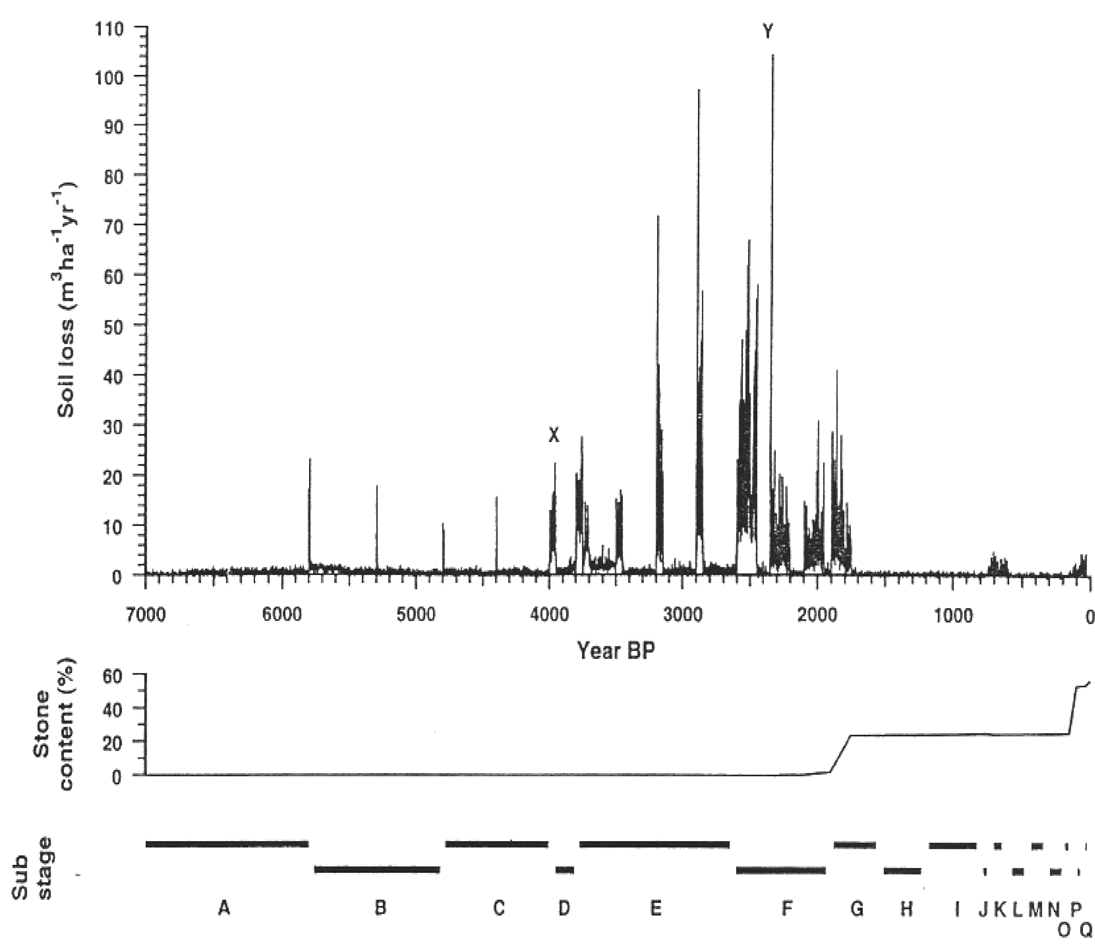
Favis-Mortlock et al. attempt to model 7000 years of erosion on a typical South Downs hillslope [19]. Changing climate, farming practices and land use are the input parameters. Soils that are assumed to be 1m thick 7000 years ago are reduced to 13 cm at the present time. Most erosion takes place in the Bronze and Iron Ages under conditions of winter cereal farming and occasional large storms (Figure 1). The general pattern of predicted erosion accords well with archaeological records.
Historical erosion is not easy to reconstruct. Day-by-day weather cannot be known and can only be simulated from broad-scale climatic information. In particular the timing and magnitude of major storms is not known. Information on surface soil conditions as a result of cultivation with farm implements is also limited. Soils were likely to have been far less stony and therefore more erodible than their modern counterparts. Stoniness has increased as soils thinned and bedrock has been ploughed-up [19]. The specific effect of fallow (weedy or not?) and the role of field-edge tracks as sites of enhanced runoff, is not known.
Figure 1.
Simulated annual erosion rates for a South Downs field over the last 7000 years (Adapted from [18]).
Figure 1.
Simulated annual erosion rates for a South Downs field over the last 7000 years (Adapted from [18]).
3. Current Erosion in Britain
3.1. Assessment of Erosion
Appropriate methods of assessment depend on objectives: what is the purpose of the assessment? National scale identification of “hotspots” of erosion will require quite different temporal and spatial scale approaches compared to assessment of a “one-off” event or the risk of erosion given certain land-use choices.
Frequently used methods of assessment of erosion are (1) experimental plots (2) sediment yield of rivers (3) field measurement of erosional forms (4) remote sensing (5) tracers (6) stratigraphy, pedology and historical documents (7) expert opinion. Details and examples are given in Boardman [32]. Evans and Brazier have compared the results from field-based monitoring and a modelling approach for the same sites in England and Wales [33]. The model seriously over-predicts erosion both in extent and amount.
Several reports and publications have used 137Cs as a means of estimating erosion in England and Wales [34,35,36]. However, rates of erosion appear to be unrealistically high as compared to field measurements from the same areas. Parsons and Foster show that the assumptions on which the technique is based have not been fully tested and that validation against more traditional methods is generally lacking [37].
In the British context, assessment of erosion has been principally based on a National Monitoring Scheme (specifically for cultivated land in England and Wales) which ran from 1982 to 1986 with 17 localities selected covering most major soil associations and in total about 700 km2 of farmland at risk of erosion [8,38,39,40]. The scheme was designed to assess if there was an erosion problem (which there was) but also to give information about process, cause and impacts. This is a unique scheme with most of the rest of Europe and the USA preferring model-based approaches for national assessment. The monitoring scheme for England and Wales used annual air photographs at 1:10,000 scale to identify eroding fields; these were then field checked and measurements made of rills, gullies and areas of deposition. The volume of rills and gullies can be estimated by measurement of length and cross-sectional area e.g., at 10 m intervals. Volume of fans is obtained from depth sampling and area measurement [40]. Subsequent monitoring schemes have covered much smaller areas [41,42]. A 10-year monitoring scheme on the eastern South Downs ran from 1982–1991 [43]. A very similar approach has been used for long-term soil erosion monitoring on arable land in Switzerland [44,45].
Assessment of the risk of erosion in Britain has been aided by a series of case studies of particular sites, areas or events all based on field observation and measurement:
- East Shropshire: 600 sites of erosion 1967–1976 in east Shropshire [9];
- Albourne, West Sussex: erosion on strawberry crop on Lower Greensand soil [48];
- South Somerset: survey of 40 fields in winter of 1982–1983 [49];
- West Midlands: major summer storm on recently planted oil-seed rape fields [53];
- East Kent: erosion on loessic soils [56].
Many of these case studies deal with unusual or catastrophic erosion events and need to be placed in the context of long-term monitored distributions.
In the uplands, a series of studies by Evans highlighted the need for assessment of the impact of overgrazing which leads to ecological damage, erosion and off-site impacts on water quality [6,30,57,58]. This led to recommendations of the Royal Commission on Environmental Pollution on the need for research [59] and subsequent surveys [60,61]. In Scotland, Grieve et al. report on upland erosion [62,63].
Figure 2.
Faringdon, Oxfordshire: effects of May thunderstorm on maize field, see [50].
Figure 2.
Faringdon, Oxfordshire: effects of May thunderstorm on maize field, see [50].

3.2. Causes of Erosion
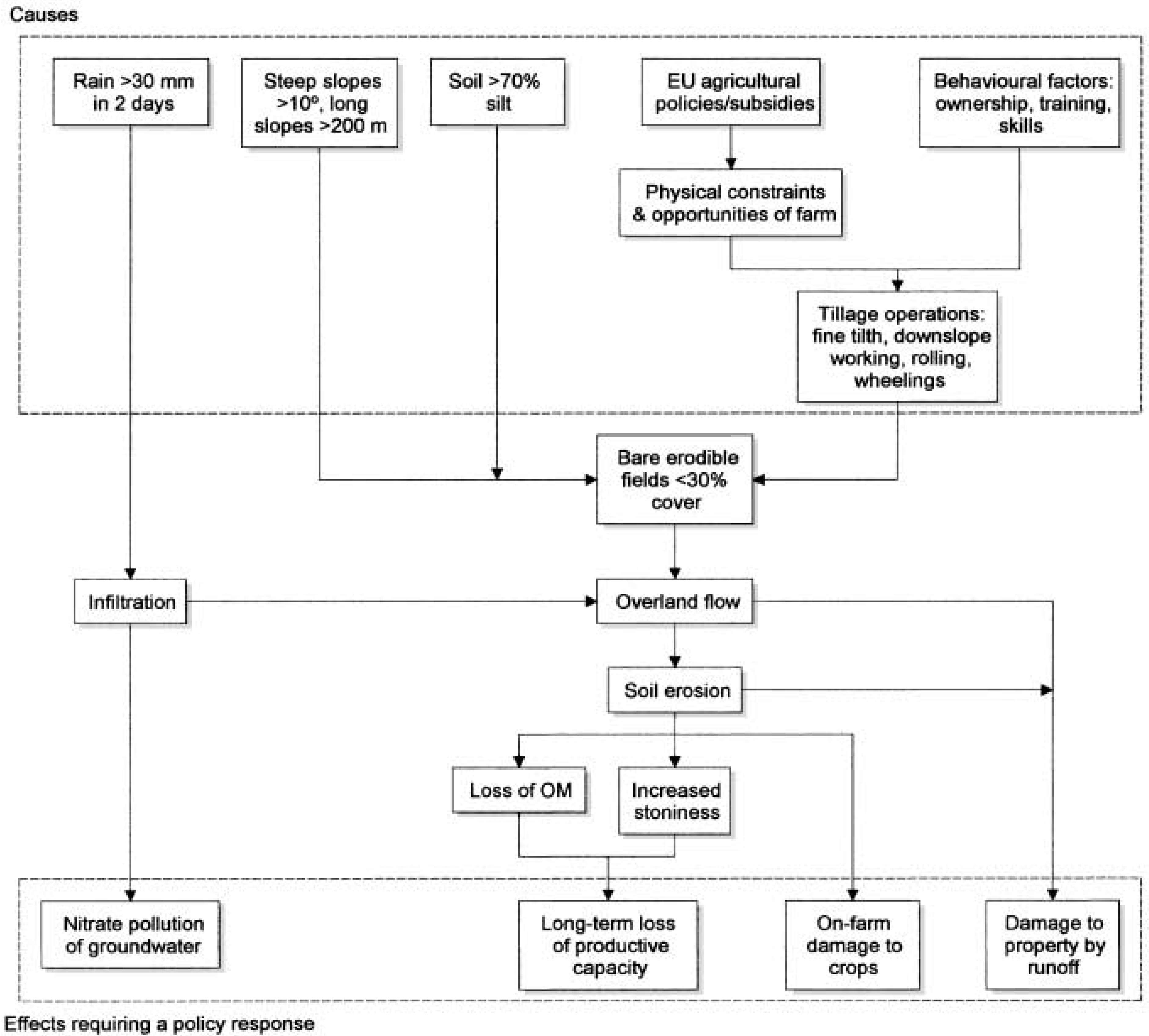
It is important to distinguish between ultimate or underlying causes and proximal or immediate causes. Ultimate causes are the socio-economic drivers of erosion, for example, the subsidies that encourage farmers to plant winter cereals on as much land as possible and therefore on some inappropriate land [64]. In the uplands, headage-based payments for sheep have led to overgrazing. Some erosion is driven by simple economic reality: high value crops such as potatoes, maize, strawberries may be grown in locations which in terms of erosion are highly risky but the short-term economic returns are seen as being worth the risk [65].
The immediate causes of erosion are those relating to erodibility of soils, farm management and weather events. It is all too easy to blame erosion on extreme weather events—and many of the case studies fall into this category—simply because researchers are more interested in the spectacular than in the mundane, but many cases of erosion occur as a result of relatively modest rainfall events e.g., 10 mm falling on saturated soils. Socio-economic factors explain why crops are grown in risky situations. Figure 3. shows the several factors that together combine to give erosion on winter cereals on the South Downs.
Figure 3.
Factors influencing soil erosion on the South Downs.

Crops are vulnerable to erosion from the time the ground is prepared to the time a sufficient crop cover exists to protect it against runoff. For different crops this time period will vary with crop growth rate and planting pattern. For example, oil-seed rape is planted close together and covers the ground very quickly: there is a low risk of erosion. In contrast, maize is planted about 0.8 m apart and takes up to three months to provide an adequate crop cover. Winter cereals on average reach a crop cover value of 30% in about two months which provides adequate protection for the soil. Unfortunately, the two month period coincides with the wettest period of the year in southern England and this coincidence is a major factor in explaining the vulnerability of winter cereals to erosion. At the same time, increases in soil moisture and cultivation-related reductions in surface roughness of the soil, all act to increase the vulnerability to runoff and erosion (Figure 4).
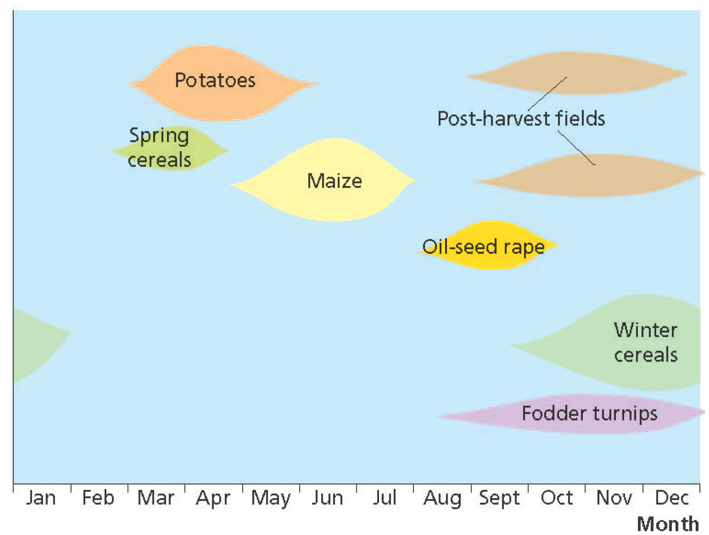
The risk of erosion on various crops is listed in Evans [8]. A similar approach is advocated by Defra [66] in their advice to farmers: the combination of crops susceptible to erosion with high-risk erosion sites is to be avoided. The failure of farmers to heed this advice at a majority of sites of erosion is discussed in Boardman et al. [65]. Risk of erosion is also a feature of post-harvest potato and maize fields due to compaction by machinery and the tendency to leave them bare in autumn and winter months: the problem is also addressed by Defra [66]. The risk periods in relation to soil erosion for various commonly grown crops in southern England are shown in Figure 5.
Figure 4.
Crop cover, soil moisture, surface roughness and rainfall with reference to a “typical” winter cereal field on the eastern South Downs [43].
Figure 4.
Crop cover, soil moisture, surface roughness and rainfall with reference to a “typical” winter cereal field on the eastern South Downs [43].
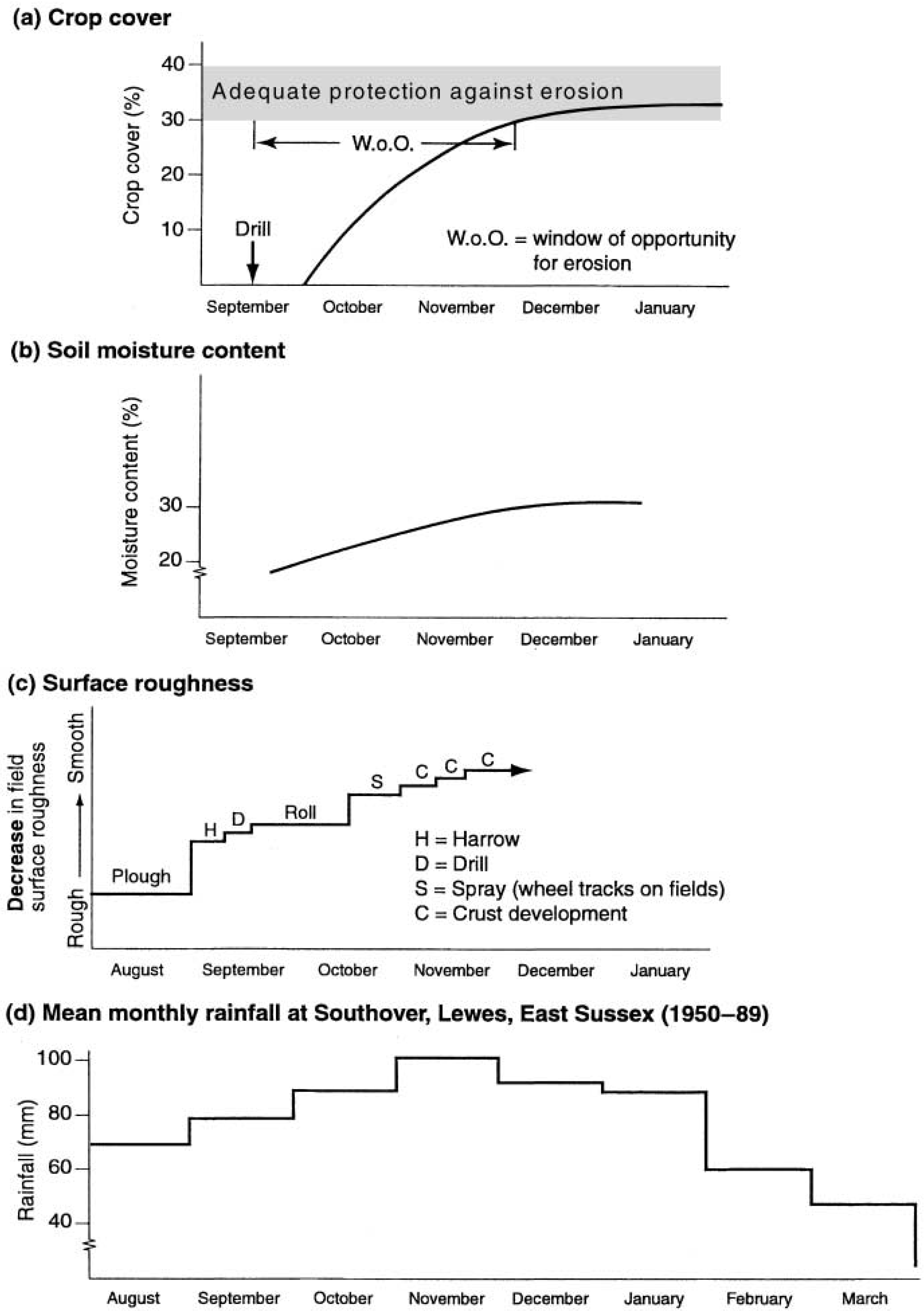
Figure 5.
Erosion vulnerability for different types of crops. The x-axis length of each shape represents the time period during which soils are vulnerable to erosion. The y-axis height of the line denotes the risk. Highest risks are associated with periods when the shapes are thickest [67].
Figure 5.
Erosion vulnerability for different types of crops. The x-axis length of each shape represents the time period during which soils are vulnerable to erosion. The y-axis height of the line denotes the risk. Highest risks are associated with periods when the shapes are thickest [67].
For different soils and different topographic situations rainfall thresholds have to be surpassed in order to generate runoff (either due to Saturation-Excess Overland Flow (SEOF) or Infiltration-Excess Overland Flow (IEOF)—or a combination of both). In the case of the South Downs, newly planted winter cereal fields generally require about 30 mm of rainfall over a two-day period for runoff to occur. This threshold is surpassed in all years. Crusting can develop on soils after varying amounts of rainfall depending on their texture. Well crusted soils give rise to IEOF. This may occur as a result of one severe storm (e.g., 63 mm on 7 October 1987 or 100 mm on 11 October 2000 on the South Downs) or a series of rainfall events. In northern France, Papy and Boiffin suggest that around 450 mm of cumulative rainfall is required to decrease the roughness of a soil surface from “recently ploughed” to “strongly crusted”—this may take place over weeks or months [68].
Decisions made at the farm-scale greatly influence vulnerability to erosion. It is suggested that the increased use of the power-harrow to produce finer tilths [69] and declines in organic matter in soils may have contributed to erosion. Data from the national Soil Inventory of England and Wales shows carbon losses of 0.6% yr−1 for 1978–2003 [70]. Some of the decline in organic matter may have been caused by dilution following deeper ploughing over the last 15 years [71]. These changes may have led to a decrease in aggregate stability and therefore a higher risk of erosion. A later survey confirms decreases in carbon content of arable soils in Great Britain [72]. Stark contrasts in organic levels in soils related to land use and the history of cultivation are in seen in Table 2. Compaction on fields associated with vehicle wheel tracks (wheelings) is often observed as the focus of erosion with rills developing along wheelings [73]. The impact of wheelings on runoff, sediment and nutrient losses is examined in a study by Withers et al. [74].
Table 2.
Levels of organic carbon in South Downs soils around Houndean, Lewes, 1982–1983 [75].
| Land-use | % organic carbon(8 random samples from within each land-use block) | Mean | |||||||
|---|---|---|---|---|---|---|---|---|---|
| Woodland-scrub | 6.5 | 6.4 | 6.0 | 6.2 | 6.0 | 6.5 | 6.3 | 6.3 | 6.3 |
| Permanent grassland | 12.4 | 12.0 | 11.9 | 12.2 | 11.4 | 11.8 | 11.6 | 12.2 | 11.9 |
| Converted to arable post1978 | 10.5 | 11.2 | 9.8 | 11.1 | 11.0 | 10.9 | 8.6 | 10.9 | 10.5 |
| Converted to arable 1955–1978 | 5.6 | 5.7 | 4.9 | 5.3 | 5.0 | 5.5 | 6.0 | 5.6 | 5.5 |
| Arable pre1945 | 3.4 | 2.5 | 3.2 | 3.1 | 2.5 | 3.3 | 3.1 | 3.8 | 3.1 |
Loss of field boundaries and therefore increase in the size of fields and the length of slopes is undoubtedly a factor in many arable areas. But this is accompanied by the tendency for large blocks of the same crop which gives rise to bare ground at the same time of the year and therefore the possibility for flows of runoff over long distances. This is well illustrated in the case on the Sompting catchment [18] where about 60% of a 10 km2 catchment was under winter cereals. Simple measures to interrupt flows with small areas of grass solved a serious off-site flooding problem.
Wind erosion is related to the enlargement of fields and the production of fine seedbeds, the increase in area of spring-planted vegetable crops and the draining and conversion to arable of former peat and sandy lands [13].
The major factor in the erosion of the uplands appears to be overgrazing largely by sheep. Evans shows that the initiation and expansion of bare soil and its subsequent erosion by the weather and animals was related to the intensity of grazing [57]. Reduction of sheep numbers reduced erosion. The high numbers of sheep are a result of the method of subsidy which led to unsustainable numbers and ecological damage to heather, and erosion [30].
3.3. Where is Erosion Occurring?
Several maps have been published showing areas at risk of erosion, all are based on the monitoring surveys in the 1980s and 1990s plus other published and unpublished data. All are unsatisfactory in printed form because of scale issues. Most usefully, Evans lists all 296 soil associations in England and Wales and classifies them in terms of risk [76]. For example, eight associations are “at high risk of accelerated erosion by water” and four at very high risk. The extent of the association is shown on the sheets of the National Soil Map of England and Wales at 1:250,000 scale [77] and details of the associations are in accompanying memoirs [78].
In general, certain areas are known for their susceptibility to erosion under current land use:
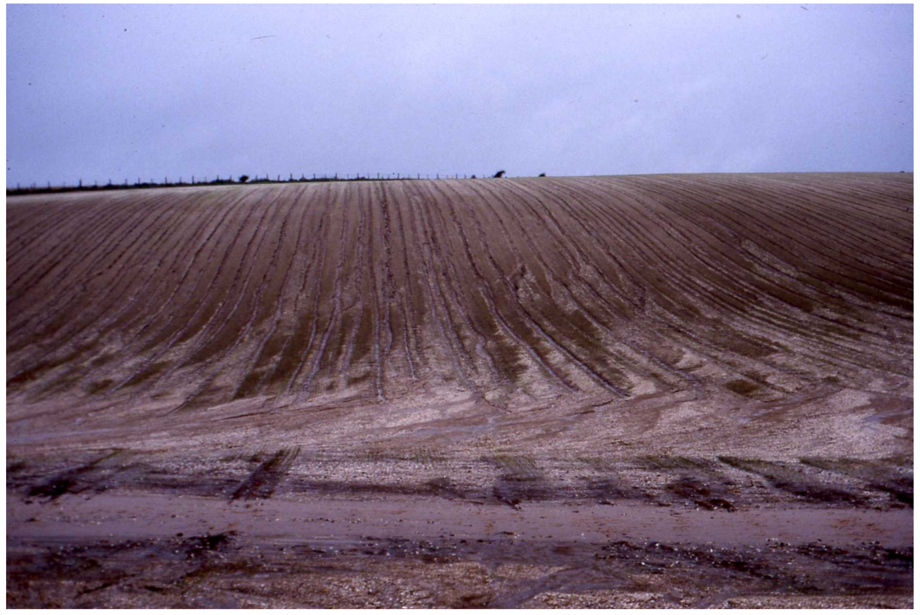
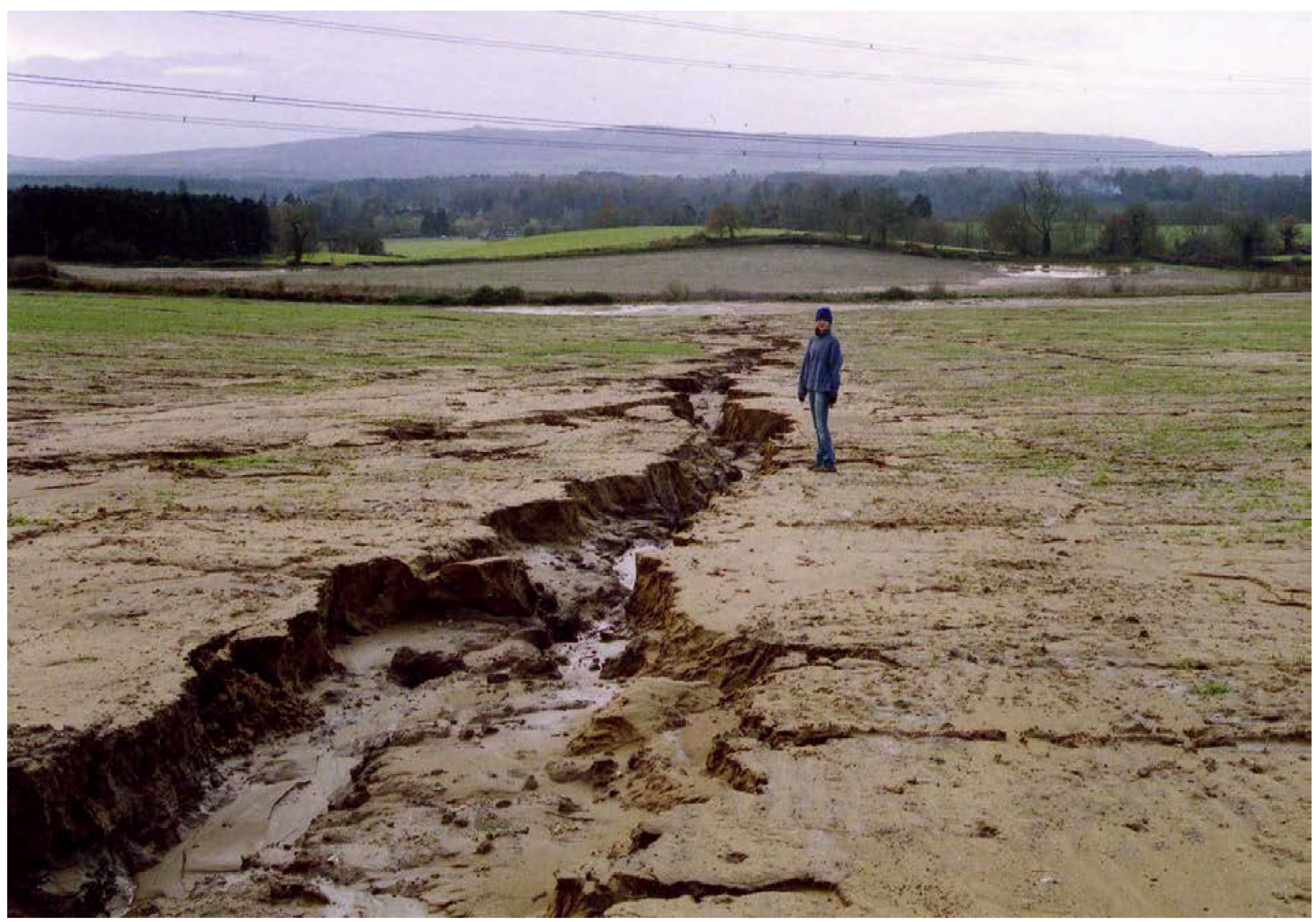
- Red sandstone soils of the East and West Midlands and south Devon e.g., areas around Retford (Nottinghamshire), Bridgnorth (Shropshire) and Dawlish (Devon); cases of both water and wind erosion are recorded in these areas (Figure 6).
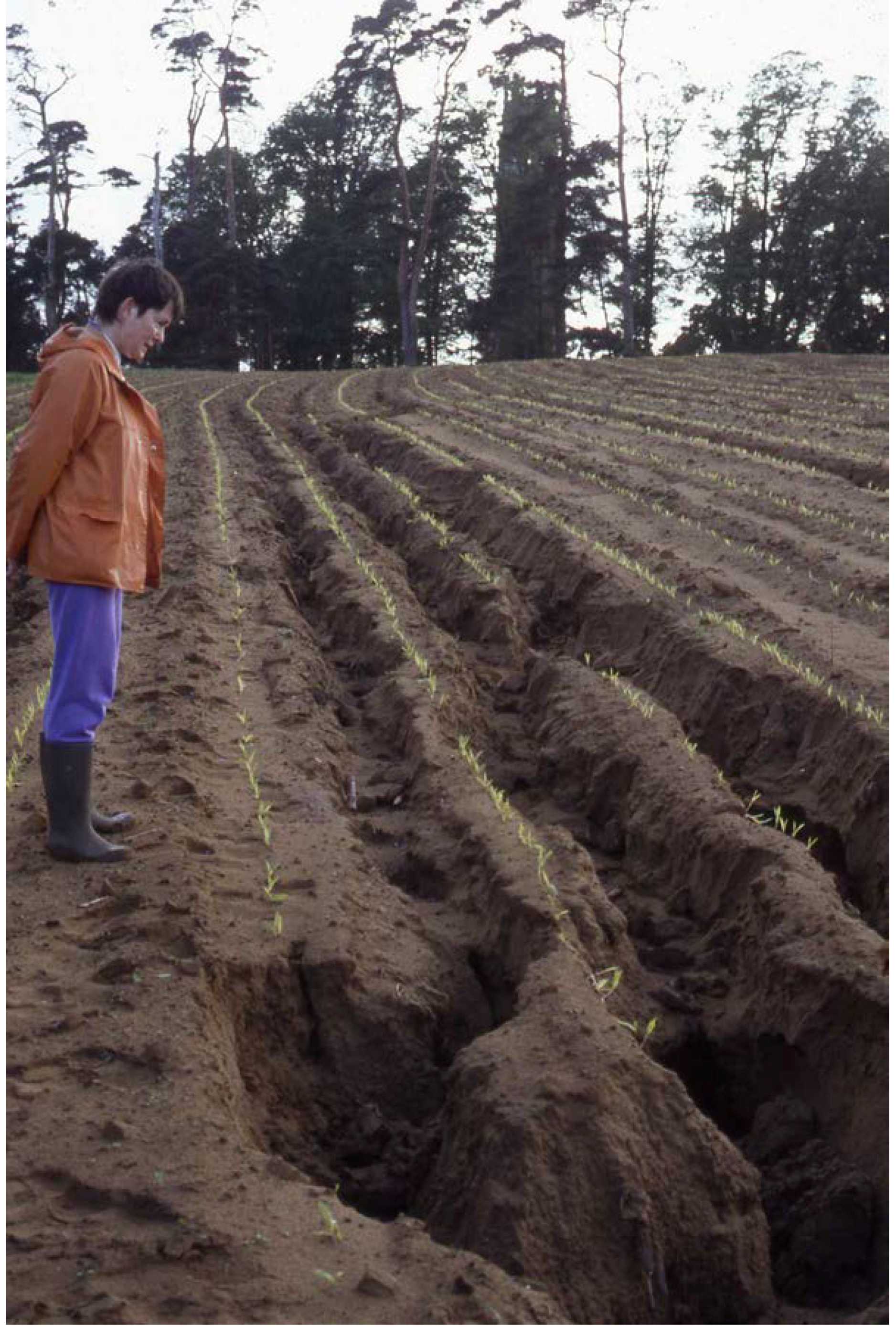
- Chalklands of southern England: not because of the inherent erodibility of the soils but because of large areas under winter cereals, large fields and compaction along wheelings (Figure 7).
- Lower Greensand soils of Bedfordshire, West Sussex and the Isle of Wight which tend to be intensively farmed with crops such as potatoes, maize, vegetables and some cereals (Figure 8).
- Silty and fine sandy soils in Somerset e.g., on the Bridport Sands around Yeovil.
The erosion situation in Scotland has not been systematically monitored but a series of studies have highlighted a problem on arable land in the east of the country [55,69,79,80,81,82,83] and in the uplands [62,63].
Wind erosion was widespread in the Fens, sandlands of Nottinghamshire, Breckland and the Vale of York on peaty and sandy soils. Evans reports a series of major erosion events in these areas in the 1960s–1980s [3]. Such events are now less common due to changes in crops particularly the expansion of winter cereals, the loss of erodible peat soils, and the adoption of protective measures.
Figure 6.
Erosion on red sandstone soils in south Devon.

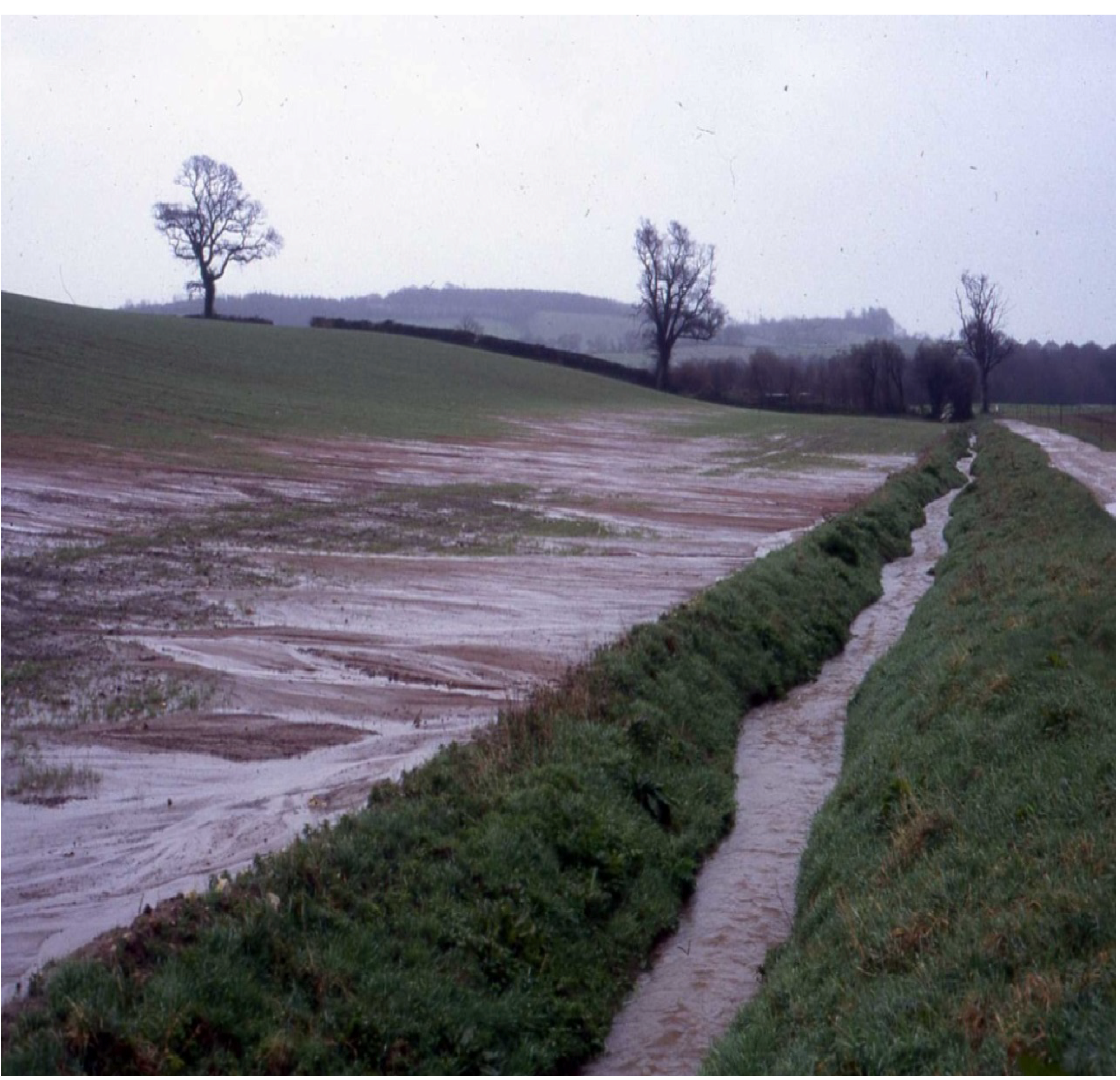
Figure 7.
on winter cereal field, Rottingdean, East Sussex, October 1987 [50].
Figure 7.
on winter cereal field, Rottingdean, East Sussex, October 1987 [50].
In terms of crop types on which erosion is occurring the data is available from the National Soil Monitoring Scheme (1982–1986) (Table 3). The majority of eroded fields are in winter cereals because of the area that the crop covers (60% of the national crop area). But rates of erosion are over twice as high in market garden crops, maize, ley grass and hops; and significantly higher in sugar beet and potatoes.
| Crop | No. eroded fields | Mean rate(m3/ha) | Median rate(m3/ha) | national crop area (%) |
|---|---|---|---|---|
| Market garden & vegetables | 102 | 5.08 | 1.47 | 3.1 |
| Maize | 26 | 4.48 | 1.00 | 0.4 |
| Ley Grass | 68 | 4.09 | 1.14 | 4.8 |
| Hops | 8 | 3.92 | 1.01 | 0.1 |
| Sugar beet | 296 | 3.04 | 0.92 | 4.4 |
| Otder 2 | 49 | 2.67 | 1.07 | 1.1 |
| Potatoes | 171 | 2.53 | 1.01 | 3.2 |
| Kale & otder fodder crops | 12 | 2.10 | 1.41 | 0.6 |
| Oilseed rape | 25 | 1.92 | 0.30 | 5.2 |
| Winter cereals 3 | 689 | 1.85 | 0.68 | 60.2 |
| Spring cereals 4 | 186 | 1.75 | 0.71 | 13.6 |
| Bare soil/fallow 5 | 25 | 1.61 | 0.27 | 1.1 |
| Peas | 16 | 1.21 | 0.91 | 1.3 |
| Field beans | 6 | 0.47 | 0.22 | 0.9 |
1 Data from national soil monitoring scheme 1982–1986; 2 Crops include soft fruit, root crops for stock feed, strawberries, orchards linseed etc; 3 Dominantly wheat, but also barley and to a lesser extent oats and triticale; 4 Predominantly spring barley; 5 Soil surface cu ltivated but not drilled or rough fallow.
3.4. Rates of Erosion
Rates of erosion for eroded fields in the monitored areas are available for 1982–1986 (Table 4). Medians are preferred to means as measures of central tendency because of the skewed nature of erosion data with many more small than large events. Values tend to be low with “hotspots” in Kent, Somerset and Isle of Wight. The Kent values are probably enhanced by the use of irrigation on market garden crops. The values would have been higher had the programme extended into the wet year 1987.
A 10-year monitoring project on about 35 km2 of the eastern South Downs largely on winter cereals fields, ran from 1982 to 1991 [43]. Median values vary from 0.5 to 5.0 m3 ha−1 yr−1 (Table 5). The value of 5.0 based on 97 eroding sites contrasts with the Andover 1 value in the Table 4 because of the wetness of 1987 [50]. Very similar methods of estimating loss of soil were used in both studies. In 1987 losses of 200 m3 ha−1 were recorded on one 12 ha field at Rottingdean.
Table 4.
Rates of erosion at 17 monitored localities in England and Wales, 1982–1986 and of the soil associations within them with more than 30 eroded fields [15].
| Locality | Erosion (m3 ha−1) | Soil association | Erosion (m3 ha−1) | Topsoil texture | ||||
|---|---|---|---|---|---|---|---|---|
| Median | Mean | No | Median | Mean | No | |||
| Bedfordshire | 0.31 | 0.47 | 65 | 411d Hanslope | 0.29 | 0.58 | 49 | Clayey |
| Cumbria | 0.36 | 1.50 | 34 | - | - | - | - | - |
| Devon | 1.22 | 1.51 | 19 | - | - | - | - | - |
| Dorset | 0.81 | 1.35 | 92 | 411b Evesham 2 | 0.74 | 1.41 | 63 | Clayey |
| Gwent | 0.83 | 1.43 | 73 | 571b Bromyard | 0.80 | 1.29 | 31 | Fine silty |
| 541a Milford | 0.79 | 2.08 | 35 | Fine loamy | ||||
| Hampshire | 1.33 | 3.95 | 59 | 571i Harwell | 1.30 | 3.52 | 55 | Loamy |
| Herefordshire | 0.68 | 1.20 | 89 | 571b Bromyard | 0.67 | 1.40 | 68 | Fine silty |
| Isle of Wight | 1.52 | 4.39 | 141 | 571g Fyfield 4 | 1.62 | 5.54 | 128 | Coarse loamy+sandy |
| Kent | 3.58 | 4.82 | 41 | - | - | - | - | - |
| Norfolk East | 0.76 | 1.03 | 118 | 551g Newport 4 | 0.50 | 1.10 | 40 | Sandy |
| 541t Wick 3 | 0.38 | 1.05 | 63 | Coarse loamy | ||||
| Norfolk West | 0.25 | 0.85 | 110 | 343g Newmarket 2 | 0.58 | 112 | 60 | Coarse loamy+sandy |
| 581f Barrow | 0.19 | 0.92 | 45 | Coarse loamy | ||||
| Nottinghamshire | 0.71 | 1.49 | 209 | 551b Cuckney 1 | 0.72 | 2.32 | 191 | Sandy+coarse loamy |
| Shropshire | 0.90 | 2.36 | 197 | 572m Salwick | 1.25 | 3.33 | 36 | Fine loamy |
| 551d Newport 1 | 0.97 | 2.55 | 38 | Sandy+coarse loamy | ||||
| 551a Bridgnortd | 0.96 | 2.76 | 94 | Sandy+coarse loamy | ||||
| Somerset | 2.55 | 4.69 | 161 | 541m S. Petderton | 2.10 | 4.76 | 114 | Silty |
| 572i Curtisden | 1.39 | 2.58 | 30 | Silty | ||||
| Staffordshire | 0.82 | 2.43 | 205 | 551a Bridgnortd | 1.06 | 3.15 | 100 | Sandy+coarse loamy |
| 551g Newport 4 | 0.66 | 2.60 | 53 | Sandy | ||||
| Sussex East | 0.32 | 0.62 | 30 | - | - | - | - | - |
| Sussex West | 0.29 | 0.80 | 62 | 343h Andover 1 | 0.37 | 1.02 | 32 | Silty |
4. Impacts of Erosion
4.1. On-Site Impacts
Erosion affects the operation of land managers particularly farmers in both the short and long term. Short term effects include loss of seeds and crops, inconvenience in terms of field operations especially harvesting where gullies occur, and damage due to muddy runoff to farm tracks, implements and buildings. However, rates of erosion on a particular field have probably to be in excess of 50m3 ha−1 yr−1 and gullies to occur which inhibit operations, for impacts to be a serious consideration for the farmer. Even then, financial losses are likely to be small compared to off-site losses [84].
Table 5.
Soil loss on eroding fields in the monitored area of the eastern South Downs 1982–1991 [43].
| Median soil loss (m³ ha−1) | Total soil loss (m³) | Number of sites | |
|---|---|---|---|
| 82–83 | 1.7 | 1816 | 68 |
| 83–84 | 0.6 | 27 | 7 |
| 84–85 | 1.1 | 182 | 25 |
| 85–86 | 0.7 | 541 | 49 |
| 86–87 | 0.7 | 211 | 34 |
| 87–88 | 5.0 | 13529 | 97 |
| 88–89 | 0.5 | 2 | 1 |
| 89–90 | 1.4 | 940 | 51 |
| 90–91 | 2.3 | 1527 | 43 |
| 91–92 | 1.2 | 112 | 14 |
If we are willing to consider the longer time scale then the loss of soil will impact on our ability to grow crops. This will be especially apparent on thin soils overlying bedrock. Several studies have suggested time scales over which impacts on crop yields will become apparent [13,46,85,86]. These tend to be in the order of hundreds of years. Recent concerns for the sustainability of landscapes, and the non-agricultural services provided by soils, especially where these are not essential or ideal for arable production, suggest that we should take a broader and longer-term view of soil protection [87,88].
4.2. Off-Site Effects of Soil Erosion
Off-site impacts of erosion are increasingly recognised as of major concern in Europe [89] and in Britain [13,15].
Peat erosion on moorlands results in reservoir sedimentation and the costs of cleaning of dirty water before it can be used for human consumption [90]. On lowland rivers the costs of ensuring that drinking water is of adequate standard is enormous; only some of these costs are related to erosion and runoff from arable land (reviewed by Evans) [91]. There are also considerable costs related to pesticides, phosphorus and nitrate transfer from arable fields to rivers, some of which travels attached to soil particles and results in eutrophication. Cost estimates vary from £168 million [92] to £260 million per year [93].
Flooding of properties by runoff from agricultural fields (“muddy floods”) has been an issue since first noted by Morgan [11] and described in some detail for one site on the South Downs by Stammers and Boardman [12]. Evans costs the impact of muddy flows on property and roads [13]. It is probably a grossly underestimated phenomenon in that few studies have attempted to collect data systematically although areas such as the Isle of Wight, the west Midlands, Somerset and Dorset, south Devon, and the South Downs regularly report flooding [94,95,96]. On the eastern South Downs 138 damaging floods have been recorded between 1976 and 2001 [43,97]. Muddy runoff from the farming of outdoor pigs is particularly prevalent in East Anglia and has resulted in a number of muddy runoff events onto roads and into houses leading to litigation [98,99].
Of growing concern has been siltation of rivers by fine sediment from arable fields. Apart from transfer of pollutants, fine sediment affects formerly gravel-bedded rivers and makes them unsuitable for fish spawning e.g., trout streams of southern England such as the western Rother, Wiltshire Avon, Test, Itchen and Allen have all reported problems [100]. Harrod reported high levels of the herbicides aldrin and dieldrin in runoff from daffodil fields reaching the Newlyn River, Cornwall, affecting eels and aquatic invertebrates [101]. This was a result of erosion during low intensity rainfall events. Evans reports on losses of nitrogen, phosphorus and atrazine to rivers and the sea [102]. Erosion on fields of potatoes, winter cereals, maize and salad crops, in the western Rother valley, West Sussex, regularly affect the river and threaten the viability of fish spawning [65,103,104].
New methods of ascribing the source of fine-grained sediments from arable fields and river banks using fingerprinting approaches are now available and emphasise the importance of compacted areas such as wheelings [105].
Much of the current concern about fine sediment transport to watercourses associated with frequent, low magnitude runoff events is focused on unwanted nutrient enrichment and pesticide levels. Pesticide levels above present threshold levels (EU Drinking Water Directive) are frequently recorded, for example in the River Cherwell, Oxfordshire [106].
5. Measures to Prevent Erosion and off-Site Impacts
In the 1980s and early 1990s few measures were in place to control erosion. Government attitudes were that it was a localised and on-farm problem. This began to change for various reasons: crop prices declined; there was much criticism of uncontrolled farming subsidies and over-production of food crops; the growth of an effective environmental movement and an interest in the sustainable use of soils. Over-production meant that governments throughout Europe were looking to move funding for agriculture into support for environmentally-friendly approaches to landscape protection such as the Environmentally Sensitive Area scheme of the late 1980s. Thus funding, for example, was linked to reduced stocking densities with consequent conservation benefits particularly in the uplands.
The growing awareness of the off-farm impacts of erosion and externalities associated with agriculture, especially those affecting water quality [107], has led to attempts to control inputs of pollutants including sediment from agricultural fields to rivers. The European Water Framework Directive came into force in 2000 and by 2015 all inland and coastal water bodies must reach good quality or “good ecological status”.
In southern England, the problem of flooding of properties by runoff from agricultural fields (“muddy floods”) illustrates many of these changes without having reached an entirely satisfactory conclusion. Early measures tended to focus on the provision of emergency protection for affected properties (ditches, dams, pipes) without changing the basic cause. Principal players were local authorities who tended to negotiate on behalf of affected individuals without having a long-term interest in solutions. In some cases, houses were flooded on several occasions before effective action was taken e.g., at Sompting and Breaky Bottom on the South Downs. In some fortuitous cases, local authorities owned the farmland and could therefore put pressure on tenant farmers to change farming practices or land use in return for rent reduction e.g., Rottingdean. To some extent the problem has been lessened by a reduction in intensive arable farming in sensitive areas such as the South Downs though wet autumns such as 2000 still result in muddy flooding [43]. The focus may now have shifted to areas of continued production of high-value crops (maize, potatoes, strawberries) on erosion-prone soils e.g., the Midhurst area of West Sussex or the Lugg and Wye catchments in Herefordshire [65,67,108].
In several cases attempts have been made to sue those responsible for flooding for negligence where it must be shown that there was knowledge of the risk to the neighbour if certain practices were continued. These cases have met with varied success the issue often being the balance between unwise (“risky”) land use practices and exceptional rainfall. At Breaky Bottom two out-of-court settlements persuaded the farmer responsible to change his land use including introducing trial areas of no-till cereals. In East Anglia, flooding of property by runoff from outdoor pig fields carrying soil particles and faeces resulted in a successful court case and an imposed agreement with respect to future land use [98].
At Sompting, West Sussex, a simple and relatively inexpensive change to grass on a small area of a large catchment resulted in interruption of regular down-valley floods which affected houses. In the exceptionally wet autumn of 2000 no flooding occurred at this site [18]. This seems to offer a model to many areas where muddy runoff affects watercourses and property. On the Isle of Wight, the County Council successfully used the Highways Act (1980) to persuade farmers who were generating muddy runoff from fields to take preventative action or risk being billed for protective engineering works by the council [94]. This is an approach that has been ignored by other local authorities.
The new Single Payment system of funding farmers means that they must under cross-compliance regulations fill in forms that state that action is being taken to prevent erosion and runoff. Recently revised advice from Defra lists ways in which erosion can be prevented for most crops [66].
Defra, in partnership with Natural England and the Environment Agency, has also set up the Catchment Sensitive Farming Delivery Initiative to address pollution in 50 designated catchments which suffer from water quality, pollution and erosion problems. This approach is voluntary with an emphasis on providing advice to farmers. In contrast, very effective measures are in place in parts of Flanders, Belgium, based on the provision of technical advice and grants for income-foregone and costs of mitigation measures. This approach has substantially reduced the risk of muddy flooding to villages in the area [109].
A simple approach to erosion risk assessment is proposed by Defra [66] based on the characteristics of the site: soil texture, slope and observations regarding the frequency of rills, gullies and runoff/sediment generation. The risks of particular crops on high risk sites are well documented. The approach is less good for situations where runoff and sediment passes from field to field creating off-site damage: a series of low-risk fields may give rise to serious downslope problems which this scoring system does not recognise [18,65].
Figure 5 illustrates a straightforward approach to risk management. This is based on field observation and shows the relative risk for different crops in a given area. Changes in patterns of rainfall (seasonality) will change this “average” picture. In some parts of the country because of the area under certain crops the risk will be higher on spring-planted crops e.g., maize and potatoes than on winter cereals. Recent observations suggest that in areas of summer cropping the risk of runoff and erosion on post-harvest fields of maize and potatoes is being underestimated. Advice on the avoidance of such problems is clear in Defra [66] but is often ignored. In recent years maize and potatoes have often been introduced into high rainfall areas of the country which are not really suited to arable farming. The increased area under maize and outdoor pigs has probably compensated for the decline in erosion in arable cultivation since the introduction of set-aside [110].
In the uplands, erosion due to overgrazing can be controlled by reduction in sheep numbers although results may take some time before they become apparent [58,111]. Threshold numbers at which erosion occurs are discussed by Evans [58]. High numbers were encouraged by subsidies based on number (headage payments) and recent reductions in numbers have come about through area-based payments with management agreements which limit stocking e.g., through the Environmental Sensitive Area scheme.
6. The Future
Any assessment of current erosion is bound to be vulnerable to future changes in land use and climate [112]. Quite apart from changes related to normal rotations, changes in land use can happen rapidly driven by changes in prices and policies. Areas planted to oil-seed rape and linseed seem particularly susceptible to year-on-year change. More long term trends that clearly affect the risk of erosion are the expansion of maize in England (partly driven by warmer summers) and the growth in outdoor pig production.
Climate scenarios for the period up to 2080 suggest winter precipitation increases of up to 30% in southern England and warmer and drier summers [113]. The erosion risks would seem to be associated with more summer thunderstorms affecting spring-planted crops and a continuing threat of erosion on winter cereals. The recent trend to poly-tunnel cultivation of strawberries, and potatoes on or near flood plains in the Wye and Lugg catchments, has led to damaging runoff affecting watercourses, roads and houses. Climate change may encourage a movement of arable farming into more upland areas: conversion of grazing land to arable runs the risk of erosion in wetter years [114]. Greater emphasis is likely on the services provided by soils particularly their role in carbon storage and in flood mitigation, both of which have close links to land use and therefore the risks of soil erosion.
Evans has argued that the growing intensification of agriculture over the last 50 years and its focus on highly mechanised food production has led to significant increases in erosion. In recent years agri-environment schemes, and the actions of individual farmers have reduced erosion but these gains have been off-set by the expansion of maize and outdoor pigs. Closely associated with erosion is the extensive movement of nutrients and pesticides from fields to watercourses resulting in pollution levels that regularly exceed EU thresholds. “Either regulations or how the land is farmed will have to change” [17].
7. Conclusions
It is probable that there is more information available about erosion and its consequences for Britain than for any other country and most of this has been gathered by field studies rather than modelling exercises [115]. The importance of the monitoring schemes has been emphasised and the need to continue with surveillance in times of changing land use and climate is clear. Over the last thirty years the emphasis has shifted from concern about on-farm to off-farm impacts of erosion. This is likely to continue due to the emergence of water quality as an issue and the Water Framework Directive with its series of targets for improvement over the next ten years. This challenge is something that the agricultural industry and the Environment Agency will have to face. The need to address catchments as a whole in water management is not a new theme in geomorphological writing and it is relevant to the issue of soil erosion since the sources and routeways of sediment reaching watercourses need to be identified. Maybe the era of “end-of-pipe solutions” is coming to an end?
Acknowledgements
I thank Bob Evans for many useful comments on this chapter. Figure 5 is reproduced from Geography Review with permission.
Conflicts of Interest
The author declares no conflict of interest.
References
- Bergsma, E. Terminology for Soil Erosion and Conservation. In Presented at International Society for Soil Science, Wageningen, The Netherlands, 1996.
- Govers, G.; Poesen, J. Assessment of the interrill and rill contributions to total soil loss from an upland field plot. Geomorphology 1988, 1, 343–354. [Google Scholar] [CrossRef]
- Evans, R.; McLaren, D. Soil Erosion and Its Impacts in England and Wales; Friends of the Earth: London, UK, 1996; p. 31. [Google Scholar]
- Ruysschaert, G.; Poesen, J.; Verstraeten, G.; Govers, G. Soil losses due to crop harvesting in Europe. In Soil Erosion in Europe; Boardman, J., Poesen, J., Eds.; Wiley: Chichester, UK, 2006; pp. 609–621. [Google Scholar]
- Van Oost, K.; Govers, G. Tillage erosion. In Soil Erosion in Europe; Boardman, J., Poesen, J., Eds.; Wiley: Chichester, UK, 2006; pp. 599–608. [Google Scholar]
- Evans, R. The need for soil conservation. Area 1971, 3, 20–23. [Google Scholar]
- Boardman, J. The need for soil conservation in Britain—Revisited. Area 2002, 34, 419–427. [Google Scholar]
- Evans, R. Monitoring water erosion in lowland England and Wales—A personal view of its history and outcomes. Catena 2005, 64, 142–161. [Google Scholar] [CrossRef]
- Reed, A.H. Accelerated erosion of arable soils in the United Kingdom by rainfall and run-off. Outlook Agric. 1979, 10, 41–48. [Google Scholar]
- Morgan, R.P.C. Soil erosion in the United Kingdom: field studies in the Silsoe area 1973–75. In Occasional Paper, No. 4; National College of Agricultural Engineering: Cranfield, UK, 1977. [Google Scholar]
- Morgan, R.P.C. Soil erosion and conservation in Britain. Prog. Phy. Geog. 1980, 4, 24–47. [Google Scholar] [CrossRef]
- Stammers, R.; Boardman, J. Soil erosion and flooding on downland areas. Surveyor 1984, 164, 8–11. [Google Scholar]
- Evans, R.; McLaren, D. Soil Erosion and Its Impacts in England and Wales; Friends of the Earth: London, UK, 1996; p. 121. [Google Scholar]
- Boardman, J.; Evans, R. Soil Erosion in Britain: A Review. In Conserving Soil Resources: European Perspectives; Rickson, R.J., Ed.; CAB International: Wallingford, UK, 1994; pp. 3–12. [Google Scholar]
- Boardman, J.; Evans, R. Britain. In Soil Erosion in Europe; Boardman, J., Poesen, J., Eds.; Wiley: Chichester, UK, 2006; pp. 439–453. [Google Scholar]
- Boardman, J. The Sensitivity of Downland Arable Land to Erosion by Water. In Environmental Sensitivity; Thomas, D.S.G., Allison, R.J., Eds.; Wiley: Chichester, UK, 1993; pp. 211–228. [Google Scholar]
- Evans, R. Towards sustainable land management in Britain. Landwards 2013, Spring, 16–17. [Google Scholar]
- Evans, R.; Boardman, J. The curtailment of flooding in the Sompting catchment. Soil Use Man. 2003, 19, 223–231. [Google Scholar] [CrossRef]
- Favis-Mortlock, D.T.; Boardman, J.; Bell, M. Modelling long-term anthropogenic erosion of a loess cover, South Downs, UK. Holocene 1997, 7, 79–89. [Google Scholar] [CrossRef]
- Evans, R. Sensitivity of British Landscape to Erosion. In Environmental Sensitivity; Thomas, D.S.G., Allison, R.J., Eds.; Wiley: Chichester, UK, 1993; pp. 189–210. [Google Scholar]
- Morgan, R.P.C. Soil erosion in Britain: The loss of a resource. Ecologist 1986, 16, 40–41. [Google Scholar]
- Evans, R. Land Use and Accelerated Soil Erosion by Water in a Small catchment on the South Downs, West Sussex, England—Past and Present. In Landscapes Through the Lens; Cowley, D.C., Standring, R.A., Abicht, M.J., Eds.; Oxbow Books: Oxford, UK, 2010; pp. 129–142. [Google Scholar]
- Bell, M.; Boardman, J. Past and Present Soil Erosion: Archaeological and Geographical Perspectives; Oxbow Monograph 22; Oxbow Books: Oxford, UK, 1992. [Google Scholar]
- Bell, M. The Effects of Land-Use and Climate on Valley Sedimentation. In Climate Change in Later Prehistory; Harding, A.F., Ed.; Edinburgh University Press: Edinburgh, UK, 1982; pp. 127–142. [Google Scholar]
- Vita-Finzi, C. The Mediterranean Valleys: Geological Changes in Historical Times; Cambridge University Press: Cambridge, UK, 1969. [Google Scholar]
- Pennington, W. Vegetation History in the North West of England: A Regional Synthesis. In Studies in the Vegetational History of the British Isles; Walker, D., West, R.G., Eds.; Cambridge University Press: Cambridge, UK, 1970; pp. 41–79. [Google Scholar]
- Jones, R.; Benson-Evans, K.; Chambers, F.M. Human influence upon sedimentation in Llangorse Lake, Wales. Earth Surf. Proc. Land. 1985, 10, 227–235. [Google Scholar] [CrossRef]
- Harvey, A.M.; Oldfield, F.; Baron, A.F. Dating of post-glacial landforms in the central Howgills. Earth Surf. Proc. Land. 1981, 6, 401–412. [Google Scholar] [CrossRef]
- Evans, R. Erosion in England and Wales—The Present is the Key to the Past. In Past and Present Soil Erosion: Archaeological and Geographical Perspectives; Oxbow Monograph 22; Bell, M., Boardman, J., Eds.; Oxbow Books: Oxford, UK, 1992; pp. 53–66. [Google Scholar]
- Evans, R. Soil erosion in the UK initiated by grazing animals. Appl. Geog. 1997, 17, 127–141. [Google Scholar] [CrossRef]
- Evans, R. Soil Erosion: Its Impact on the English and Welsh Landscape since Woodland Clearance. In Soil Erosion on Agricultural Land; Boardman, J., Foster, I.D.L., Eds.; Wiley: Chichester, UK, 1990; pp. 231–254. [Google Scholar]
- Boardman, J. Soil Erosion: The Challenge of Assessing Variation through Space and Time. In Geomorphological Variations; Goudie, A.S., Kalvoda, J., Eds.; Nakladatelsti P3K: Prague, Czech Republic, 2007; pp. 205–220. [Google Scholar]
- Evans, R.; Brazier, R. Evaluation of modelled spatially distributed predictions of soil erosion by water versus field-based assessments. Environ. Sci. Pol. 2005, 8, 493–501. [Google Scholar] [CrossRef]
- Quine, T.A.; Walling, D.E. Rates of soil erosion on arable fields in Britain: Quantitative data from caesium-137 measurements. Soil Use Man. 1991, 7, 169–176. [Google Scholar] [CrossRef]
- Walling, D.E.; Quine, T.A. Use of 137Cs measurements to investigate soil erosion on arable fields in the UK: Potential applications and limitations. J. Soil Sci. 1991, 42, 147–165. [Google Scholar] [CrossRef]
- Quine, T.A.; Walling, D.E. In Farm Land Erosion: In Temperate Plains Environment and Hills; Wicherek, S., Ed.; Elsevier: Amsterdam, The Netherlands, 1993; pp. 357–371. [Google Scholar]
- Parsons, A.J.; Foster, I.D.L. What can we learn about soil erosion from the use of 137Cs? Earth Sci. Rev. 2011, 108, 101–113. [Google Scholar] [CrossRef]
- Evans, R. Assessing erosion in England and Wales. In Proceedings of the 7th ISCO ConferenceInternational Soil Conservation Organisation, Sydney, Australia, 27–30 September 1992; pp. 82–91.
- Evans, R. Extent, Frequency and Rates of Rilling of Arable Land in Localities in England and Wales. In Temperate Plains Environments and Hills; Wicherek, S., Ed.; Elsevier: Amsterdam, The Netherlands, 1993; pp. 177–190. [Google Scholar]
- Evans, R.; Boardman, J. Assessment of Water Erosion in Farmers’ Fields in the UK. In Conserving Soil Resources: European Perspectives; Rickson, R.J., Ed.; CABI: Wallingford, UK, 1994; pp. 13–24. [Google Scholar]
- Chambers, B.J.; Davies, D.B.; Holmes, S. Monitoring of water erosion on arable farms in England and Wales, 1989–90. Soil Use Man. 1992, 8, 163–170. [Google Scholar] [CrossRef]
- Chambers, B.J.; Garwood, T.W.D. Monitoring of water erosion on arable farms in England and Wales, 1990–94. Soil Use Man. 2000, 16, 93–99. [Google Scholar] [CrossRef]
- Boardman, J. Soil erosion and flooding on the eastern South Downs, southern England, 1976–2001. Trans. Inst. Brit. Geog. NS 2003, 28, 176–196. [Google Scholar] [CrossRef]
- Prasuhn, V. Soil erosion in the Swiss midlands: Results of a 10 year field survey. Geomorphology 2011, 126, 32–41. [Google Scholar] [CrossRef]
- Prasuhn, V. On-farm effects of tillage and crops on soil erosion measured over 10 years in Switzerland. Soil Till. Res. 2012, 120, 137–146. [Google Scholar] [CrossRef]
- Evans, R.; Nortcliff, S. Soil erosion in north Norfolk. J. Agric. Sci. Camb. 1978, 90, 185–192. [Google Scholar] [CrossRef]
- Evans, R. Curtailing water erosion of cultivated land: An example from north Norfolk, eastern England. Earth Surf. Proc. Land. 2006, 31, 598–605. [Google Scholar] [CrossRef]
- Boardman, J. Soil erosion at Albourne, West Sussex, England. Appl. Geog. 1983, 3, 317–329. [Google Scholar] [CrossRef]
- Colborne, G.J.N.; Staines, S.J. Soil erosion in south Somerset. J. Agric. Sci. Camb. 1985, 104, 107–112. [Google Scholar] [CrossRef]
- Boardman, J. Severe erosion on agricultural land in East Sussex, UK October 1987. Soil Tech. 1988, 1, 333–348. [Google Scholar] [CrossRef]
- Boardman, J. Storms, floods and soil erosion on the South Downs, East Sussex, autumn and winter 2000–01. Geography 2001, 84, 346–355. [Google Scholar]
- Boardman, J.; Burt, T.; Evans, R.; Slattery, M.C.; Shuttleworth, H. Soil erosion and flooding as a result of a summer thunderstorm in Oxfordshire and Berkshire, May 1993. Appl. Geog. 1996, 16, 21–34. [Google Scholar] [CrossRef]
- Foster, I.D.L.; Harrison, S.; Clark, D. Soil erosion in the West Midlands. Geography 1997, 82, 231–239. [Google Scholar]
- Watson, A.; Evans, R. A comparison of estimates of soil erosion made in the field and from photographs. Soil Till. Res. 1991, 19, 17–27. [Google Scholar] [CrossRef]
- Watson, A.; Evans, R. Water erosion of arable fields in north-east Scotland, 1985–2007. Scott. Geog. J. 2007, 123, 107–121. [Google Scholar] [CrossRef]
- Boardman, J.; Hazelden, J. Examples of erosion on brickearth soils in east Kent. Soil Use Man. 1986, 2, 105–108. [Google Scholar] [CrossRef]
- Evans, R. Overgrazing and soil erosion on hill pastures with particular reference to the Peak District. J. Brit. Grass. Soc. 1977, 32, 65–76. [Google Scholar] [CrossRef]
- Evans, R. The erosional impacts of grazing animals. Prog. Phy. Geog. 1998, 22, 251–268. [Google Scholar]
- Royal Commission on Environmental Pollution, Sustainable Use of Soil; Report No 19; Her Majesty’s Stationery Office: London, UK, 1996.
- McHugh, M.; Harrod, T.; Morgan, R. The extent of soil erosion in upland England and Wales. Earth Surf. Proc. Land. 2002, 27, 99–107. [Google Scholar] [CrossRef]
- McHugh, M. Short-term changes in upland soil erosion in England and Wales: 1999 to 2002. Geomorphology 2007, 86, 204–213. [Google Scholar] [CrossRef]
- Grieve, I.C.; Hipkin, J.A.; Davidson, D.A. Soil Erosion Sensitivity in Upland Scotland; Report No 24; Scottish Natural Heritage Research Survey and Monitoring Report: Edinburgh UK, 1994. [Google Scholar]
- Grieve, I.C.; Davidson, D.A.; Gordon, J.E. Nature, extent and severity of soil erosion in upland Scotland. Land Deg. Rehab. 1995, 6, 41–55. [Google Scholar] [CrossRef]
- Boardman, J.; Poesen, J.; Evans, R. Socio-economic factors in soil erosion and conservation. Environ. Sci. Pol. 2003, 6, 1–6. [Google Scholar] [CrossRef]
- Boardman, J.; Shepheard, M.; Walker, E.; Foster, I.D.L. Soil erosion and risk assessment for on- and off-farm impacts: A test case in the Midhurst area, West Sussex, UK. J. Environ. Man. 2009, 90, 2578–2588. [Google Scholar] [CrossRef]
- Controlling Soil Erosion; Department for Environment, Food and Rural Affairs: London, UK, 2005.
- Boardman, J. Soil erosion and farming: Assessing the risk. Geog. Rev. 2012, 26, 36–40. [Google Scholar]
- Papy, F.; Boiffin, J. The use of farming systems for the control of runoff and erosion. Soil Technol. 1989, 1, 29–38. [Google Scholar]
- Speirs, R.B.; Frost, C.A. The increasing incidence of accelerated soil water erosion on arable land in the east of Scotland. Res. Dev. Agric. 1985, 2, 161–167. [Google Scholar]
- Bellamy, P.H.; Loveleand, P.J.; Bradley, R.I.; Lark, R.M.; Kirk, G.J. Carbon losses from all soils across England and Wales 1978–2003. Nature 2005, 437, 245–248. [Google Scholar] [CrossRef] [Green Version]
- MAFF, Resource Use—Organic Matter Content of Agricultural Topsoils. In Towards Sustainable Agriculture: A Pilot Set of Indicators; Ministry of Agriculture, Fisheries and Food: London, UK, 2000; Volume PB4583, pp. 47–48.
- Emmett, B.A.; Reynolds, B.; Chamberlain, P.M.; Rowe, E.; Spurgeon, D.; Brittain, S.A.; Frogbrook, Z.; Hughes, S.; Lawlor, A.J.; Poskitt, J.; et al. Countryside Survey: Soils Report from 2007; Technical Report No. 9/07; Centre for Ecology & Hydrology: Wallingford, UK, 2010. [Google Scholar]
- Reed, A.H. The erosion risk of compaction. Soil Wat. 1983, 1, 29–33. [Google Scholar]
- Withers, P.J.A.; Hodgkinson, R.A.; Bates, A.; Withers, C.M. Some effects of tramlines on surface runoff, sediment and phosphorus mobilization on an erosion-prone soil. Soil Use Man. 2006, 22, 245–255. [Google Scholar] [CrossRef]
- Boardman, J.; Robinson, D.A. Soil erosion, climatic vagary and agricultural change on the Downs around Lewes and Brighton, autumn 1982. Appl. Geog. 1985, 5, 243–258. [Google Scholar] [CrossRef]
- Evans, R. Soils at risk of accelerated erosion in England and Wales. Soil Use Man. 1990, 6, 125–131. [Google Scholar] [CrossRef]
- Soil Survey of England and Wales, National Soil Map; Soil Survey of England and Wales: Harpenden, UK, 1983.
- Jarvis, M.G.; Allen, R.H.; Fordham, S.J.; Hazelden, J.; Moffat, A.J.; Sturdy, R.G. Soils and Their Use in South East England; Bulletin No. 15; Soil Survey of England and Wales: Harpenden, UK, 1984. [Google Scholar]
- Frost, C.A.; Speirs, R.B. Water erosion of soils in south-east Scotland—A case study. Res. Dev. Agric. 1984, 1, 145–152. [Google Scholar]
- Frost, C.A.; Speirs, R.B. Soil erosion from a single rainstorm over an area in East Lothian, Scotland. Soil Use Man. 1996, 12, 8–12. [Google Scholar] [CrossRef]
- Speirs, R.B.; Frost, C.A. Soil water erosion on arable land in the United Kingdom. Res. Dev. Agric. 1987, 4, 1–11. [Google Scholar]
- Kirkbride, M.P.; Reeves, A.D. Soil erosion caused by low-intensity rainfall in Angus, Scotland. Appl. Geog. 1993, 13, 299–311. [Google Scholar] [CrossRef]
- Davidson, D.A.; Harrison, D.J. The nature, causes and implications of water erosion on arable land in Scotland. Soil Use Man. 1995, 11, 63–68. [Google Scholar] [CrossRef]
- Robinson, D.A.; Blackman, J.D. Some Costs and Consequences of Soil Erosion and Flooding around Brighton and Hove, Autumn 1987. In Soil Erosion on Agricultural Land; Boardman, J., Foster, I.D.L., Dearing, J.A., Eds.; Wiley: Chichester, UK, 1990; pp. 369–382. [Google Scholar]
- Evans, R. Assessments of Soil Erosion and Peat Wastage for Parts of East Anglia, England, a Field Visit. In Soil Conservation: Problems and Prospects; Morgan, R.P.C., Ed.; Wiley: Chichester, UK, 1981; pp. 521–530. [Google Scholar]
- Morgan, R.P.C. Sensitivity of European Soils to Ultimate Physical Degradation. In Scientific Basic for Soil Protection in the European Community; Barth, H., L’Hermite, P., Eds.; Elsevier: London, UK, 1987; pp. 147–157. [Google Scholar]
- Evans, R. Sustainable practices to limit soil erosion: A review and discussion. CAB Rev. Perspect. Agric. Vet. Sci. Nutr. Nat. Resour. 2006, 1, 030:1–030:12. [Google Scholar]
- Boardman, J. Soils and Sustainability: The Future of the South Downs. In Sustainable Farmland Management: Transdisciplinary Approaches; Fish, R., Seymour, S., Watkins, C., Steven, M., Eds.; CAB International: Wallingford, UK, 2008; pp. 49–57. [Google Scholar]
- Boardman, J.; Poesen, J. Soil Erosion in Europe: Major Processes, Causes and Consequences. In Soil Erosion in Europe; Boardman, J., Poesen, J., Eds.; Wiley: Chichester, UK, 2006; pp. 479–487. [Google Scholar]
- Butcher, D.P.; Labadz, J.C.; Potter, W.R.; White, P. Reservoir sedimentation rates in the Southern Pennine region, UK. In Geomorphology and Sedimentology of Lakes and Reservoirs; McManus, J., Duck, R.W., Eds.; Wiley: Chichester, UK, 1993; pp. 73–92. [Google Scholar]
- Evans, R.; McLaren, D. Soil Erosion and Its Impacts in England and Wales; Friends of the Earth: London, UK, 1996; p. 52. [Google Scholar]
- Environment Agency, Agriculture and Natural Resources: Benefits, Costs and Potential Solutions; Environment Agency: Bristol, UK, 2002.
- Evans, R. Soil Erosion and Land use: Towards a Sustainable Policy. In Proceedings of the Professional Environmental SeminarCambridge Committee for Interdisciplinary Environmental Studies, Cambridge, UK, 1995; Evans, R., Ed.; White Horse Press: Cambridge, UK, 1995; pp. 14–26. [Google Scholar]
- Boardman, J. Property damage by run-off from agricultural land. Town Coun. Plan. 1994, 63, 249–251. [Google Scholar]
- Boardman, J. The problem of muddy floods. Rural Prop. Bull. 2000, November/December, 26–27. [Google Scholar]
- Boardman, J. Flooding and the use of land. Town Coun. Plan. 2001, 70, 113. [Google Scholar]
- Boardman, J.; Evans, R.; Ford, J. Muddy floods on the South Downs, southern England: Problem and response. Environ. Sci. Pol. 2003, 6, 1–6. [Google Scholar] [CrossRef]
- Evans, R. Outdoor pigs and flooding: An English case study. Soil Use Man. 2004, 20, 178–181. [Google Scholar] [CrossRef]
- Evans, R. Runoff and soil erosion in arable Britain: Changes in perception and policy since 1945. Environ. Sci. Pol. 2010, 13, 141–149. [Google Scholar] [CrossRef]
- Evans, R.; McLaren, D. Soil Erosion and its Impacts in England and Wales; Friends of the Earth: London, UK, 1996; p. 53. [Google Scholar]
- Harrod, T.R. Runoff, Soil Erosion and Pesticide Pollution in Cornwall. In Conserving Soil Resources: European Perspectives; Rickson, R.J., Ed.; CAB International: Wallingford, UK, 1994; pp. 105–115. [Google Scholar]
- Evans, R. Rural land use in England and Wales and the delivery to the adjacent seas of nitrogen, phosphorus and atrazine. Soil Use Man. 2002, 19, 1–7. [Google Scholar]
- Theurer, F.D.; Harrod, T.R.; Theurer, M. Sedimentation and Salmonids in England and Wales; R&D technical report P194; Environment Agency: Rotherham, UK, 1998; p. 63. [Google Scholar]
- Sear, D.A. Fine Sediment Accumulations in the River Rother, West Sussex; Report to Southern Region NRA: Southampton, UK, 1996; p. 27. [Google Scholar]
- Collins, A.L.; Zhang, Y.S.; Duethmann, D.; Walling, D.E.; Black, K.S. Using a novel tracing-tracking framework to source fine grained sediment loss to watercourses at sub-catchment scale. Hydrol. Proc. 2013, 27, 959–974. [Google Scholar] [CrossRef]
- Evans, R. Pesticide run off into English rivers—A big problem for farmers. Pesticide News 2009, 85, 12–15. [Google Scholar]
- Pretty, J.N.; Brett, C.; Gee, D.; Hine, R.E.; Mason, C.F.; Morison, J.I.L.; Raven, H.; Rayment, M.D.; van der Bijl, G. An assessment of the total external costs of UK agriculture. Agric. Syst. 2000, 65, 113–136. [Google Scholar] [CrossRef]
- Walker, E. Soil Erosion and DEFRA’s Catchment Sensitive Farming Programme—A Hertfordshire Case Study. Master Thesis, Environmental Change Institute, University of Oxford, UK, 2007. [Google Scholar]
- Boardman, J.; Vandaele, K. Soil erosion, muddy floods and the need for institutional memory. Area 2010, 42, 502–513. [Google Scholar] [CrossRef]
- Evans, R. Land use, Sediment Delivery and Sediment Yield in England and Wales. In Soil Erosion and Sediment Redistribution in River Catchments; Owens, P.N., Collins, A.J., Eds.; CAB International: Wallingford, UK, 2006; pp. 70–84. [Google Scholar]
- Evans, R. Curtailing grazing-induced erosion in a small catchment and its environs, the Peak District, Central Englan. Appl. Geog. 2005, 25, 81–95. [Google Scholar] [CrossRef]
- Macleod, C.J.A.; Falloon, P.D.; Evans, R.; Haygarth, P.M. The effects of climate change on the mobilization of diffuse substances from agricultural systems. Adv. Agron. 2012, 115, 41–77. [Google Scholar] [CrossRef]
- Hulme, M.; Jenkins, G.J.; Lu, X.; Turnpenny, J.; Mitchell, T.D.; Jones, R.G.; Lowe, J.; Murphy, J.M.; Hassell, D.; Boorman, P.; McDonald, R.; Hill, S. Climate Change Scenarios for the United Kingdom: The UKCIPPO2 Scientific Report; Scientific Report for Tyndall Centre for Climate Change Research, School of Environmental Sciences, University of East Anglia: Norwich, UK, 2002. [Google Scholar]
- Boardman, J.; Spivey, D. Flooding and erosion in west Derbyshire, April 1983. East Mid. Geog. 1987, 10, 36–44. [Google Scholar]
- Evans, R. Assessment and monitoring of accelerated water erosion of cultivated land—When will reality be acknowledged? Soil Use Man. 2013, 24, 105–118. [Google Scholar] [CrossRef]
© 2013 by the authors; licensee MDPI, Basel, Switzerland. This article is an open-access article distributed under the terms and conditions of the Creative Commons Attribution license (http://creativecommons.org/licenses/by/3.0/).
Share and Cite
MDPI and ACS Style
Boardman, J. Soil Erosion in Britain: Updating the Record. Agriculture 2013, 3, 418-442. https://doi.org/10.3390/agriculture3030418
AMA Style
Boardman J. Soil Erosion in Britain: Updating the Record. Agriculture. 2013; 3(3):418-442. https://doi.org/10.3390/agriculture3030418
Chicago/Turabian StyleBoardman, John. 2013. "Soil Erosion in Britain: Updating the Record" Agriculture 3, no. 3: 418-442. https://doi.org/10.3390/agriculture3030418