
Identification of Optimal Mechanization Processes for Harvesting Hazelnuts Based on Geospatial Technologies in Sicily (Southern Italy)

 ,
,  , ,
, ,  and
and
Abstract
:1. Introduction
2. Materials and Methods
2.1. Context of Study
2.2. Data Analysis and Materials
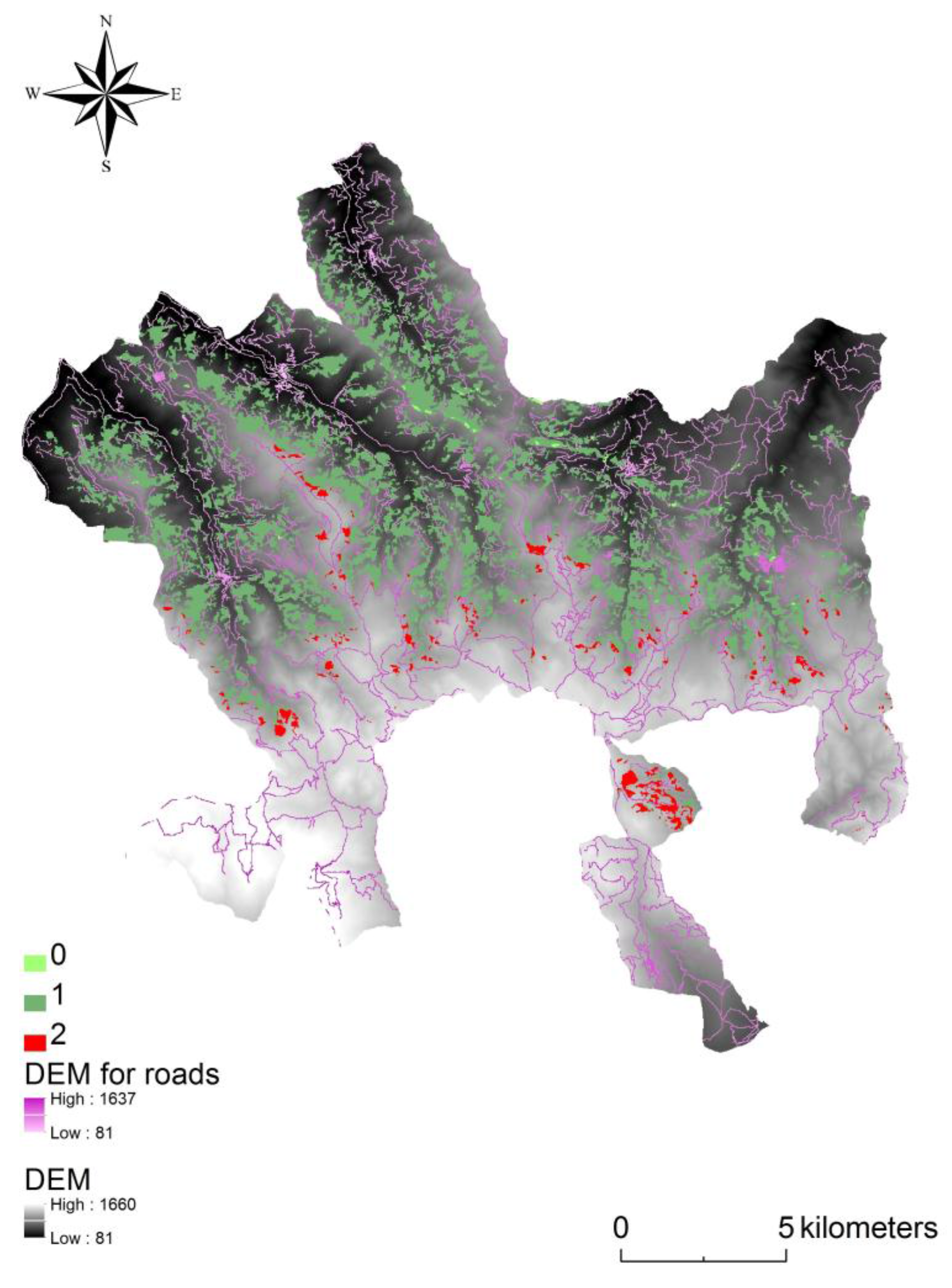
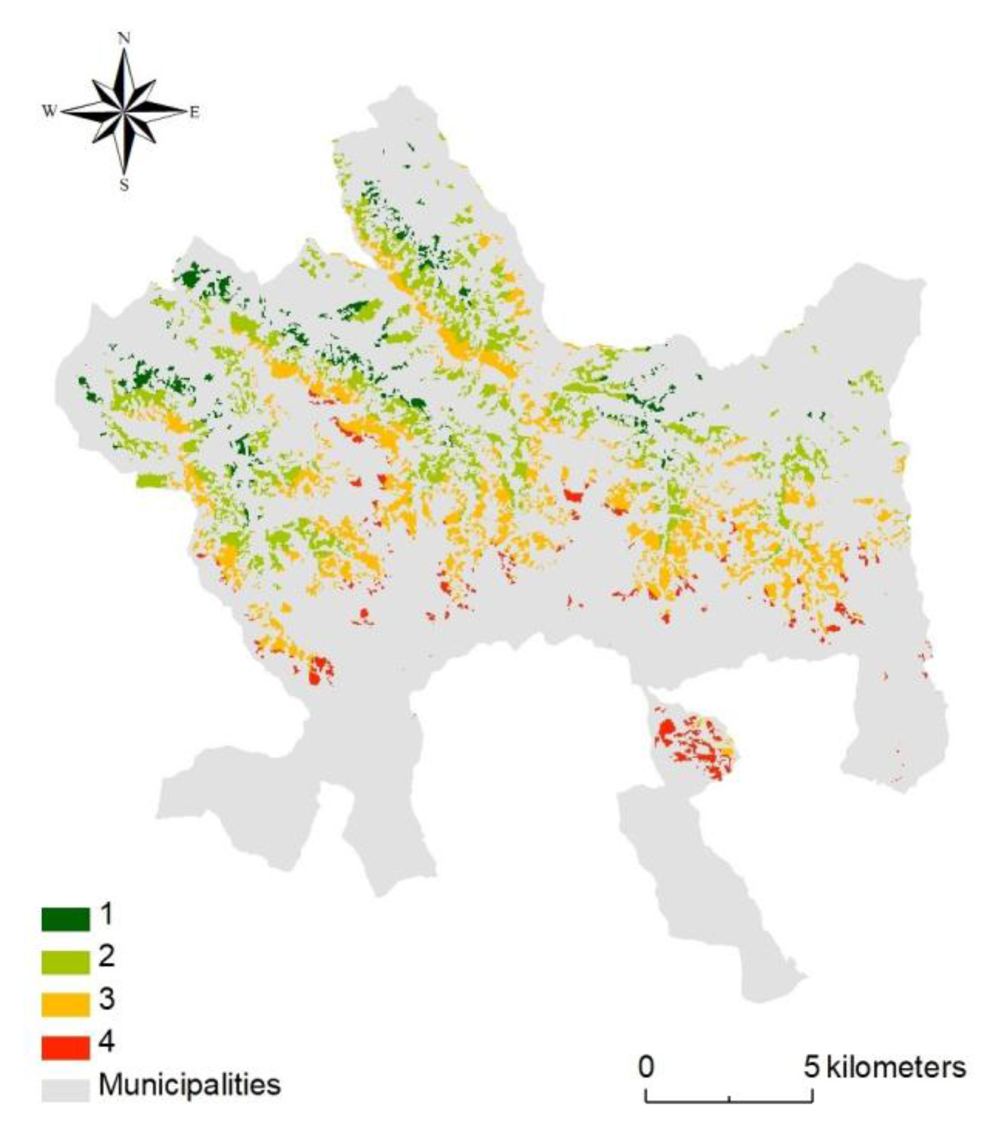
2.3. Mechanization Framework
3. Results
4. Discussion
5. Conclusions
Acknowledgments
Author Contributions
Conflicts of Interest
References
- Bonet, A. Secondary succession of semi-arid Mediterranean old-fields in south-eastern Spain: Insights for conservation and restoration of degraded lands. J. Arid Environ. 2004, 56, 213–233. [Google Scholar] [CrossRef]
- Godone, D.; Garbarino, M.; Sibona, E.; Garnero, G.; Godone, F. Progressive fragmentation of a traditional Mediterranean landscape by hazelnut plantations: The impact of CAP over time in the Langhe region (NW Italy). Land Use Policy 2014, 36, 259–266. [Google Scholar] [CrossRef]
- Sitzia, T.; Semenzato, P.; Trentanovi, G. Natural reforestation is changing spatial patterns of rural mountain and hill landscapes: A global overview. For. Ecol. Manag. 2010, 259, 1354–1362. [Google Scholar] [CrossRef]
- Sluiter, R.; de Jong, S.M. Spatial patterns of Mediterranean land abandonment and related land cover transitions. Landsc. Ecol. 2007, 22, 559–576. [Google Scholar] [CrossRef]
- FAO. Food and Agricultural Commodities Production. Available online: http://faostat.fao.org/site/339/default.aspx (accessed on 1 July 2010).
- Aydinoglu, A.C. Examining environmental condition on the growth areas of Turkish hazelnut (Corylus colurna L.). Afr. J. Biotechnol. 2010, 9, 6492–6502. [Google Scholar]
- Reis, S.; Yomralioglu, T. Detection of current and potential hazelnut (Corylus) plantation areas in trabzon, north east Turkey using GIS and RS. J. Environ. Biol. 2006, 27, 653–659. [Google Scholar] [PubMed]
- TURKSTAT. Turkish Statistical Institute. Available online: www.turkstat.gov.tr (accessed on 12 May 2001).
- Sarıoğlu, F.E.; Saygın, F.; Balcı, G.; Dengiz, O.; Demirsoy, H. Determination of potential hazelnut plantation areas based GIS model case study: Samsun city of central Black Sea region. Eurasian J. Soil Sci. 2013, 2, 12–18. [Google Scholar]
- London Economics. Evaluation of the CAP Policy on Protected Designations of Origin (PDO) and Protected Geographical Indications (PGI); European Commission—Agriculture and Rural Development: Bruxelles, Belgium, 2008; p. 275. [Google Scholar]
- Martinez-Casasnovas, J.A.; Ramos, M.C.; Cots-Folch, R. Influence of the EU CAP on terrain morphology and vineyard cultivation in the Priorat region of NE Spain. Land Use Policy 2010, 27, 11–21. [Google Scholar] [CrossRef]
- Van Berkel, D.B.; Verburg, P.H. Sensitising rural policy: Assessing spatial variation in rural development options for Europe. Land Use Policy 2011, 28, 447–459. [Google Scholar] [CrossRef]
- Westhoek, H.J.; van den Berg, M.; Bakkes, J.A. Scenario development to explore the future of Europe’s rural areas. Agric. Ecosyst. Environ. 2006, 114, 7–20. [Google Scholar] [CrossRef]
- Official Gazette. The Regulation of the Law Planning Hazelnut Production and Determining Hazelnut Plantation Areas; Official Gazette: Ankara, Turkey, 2009; p. 27289.14. [Google Scholar]
- Dengiz, O.; Ozcan, H.; Köksal, E.S.; Kosker, Y. Sustainable Natural Resource Management and Environmental Assessment in The Salt Lake (Tuz Golu) Specially Protected Area. J. Environ. Monit. Assess. 2010, 161, 327–342. [Google Scholar] [CrossRef] [PubMed]
- Lioubimtseva, E.; Defourny, P. GIS based landscape classification and mapping of European Russia. Landsc. Urban Plan. 1999, 44, 63–75. [Google Scholar] [CrossRef]
- Longley, P.A.; Goodchild, M.F.; Maguire, D.J.; Rhind, D.W. Geographic Information Systems and Science; Bath Press: London, UK, 2001. [Google Scholar]
- Bolca, M.; Kurucu, Y.; Dengiz, O.; Nahry, A.D.H. Terrain characterization for soils survey of Kucuk Menderes plain, South of Izmir, Turkey, using remote sensing and GIS techniques. Zemdirb. Agric. 2011, 98, 93–104. [Google Scholar]
- Wilkinson, G. Results and implications of a study of fifteen years of satellite image classification experiments. IEEE Trans. Geosci. Remote Sens. 2005, 43, 433–440. [Google Scholar] [CrossRef]
- Reis, S.; Taşdemir, K. Identification of hazelnut fields using spectral and Gabor textural features. ISPRS J. Photogramm. Remote Sens. 2011, 66, 652–661. [Google Scholar] [CrossRef]
- Lillesand, T.M.; Kiefer, R.W. Remote Sensing and Image Interpratation; The Lehigh Press: New York, NY, USA, 2000. [Google Scholar]
- Cohen, Y.; Shoshany, M. A national knowledge-based crop recognition in Mediterranean environment. Int. J. Appl. Earth Observ. Geoinf. 2002, 4, 75–87. [Google Scholar] [CrossRef]
- Grauke, L.J.; Thompson, T.E. Rootstock development in temperate nut crops. Genetıcs and breeding of tree fruits and nuts. Acta Hortıcult. 2003, 622, 553–566. [Google Scholar] [CrossRef]
- Yomralioglu, T.; Inan, H.I.; Aydinoglu, A.C.; Uzun, B. Evaluation of initiatives for spatial information system to support Turkish agriculture policy. Sci. Res. Essay 2009, 4, 1523–1530. [Google Scholar]
- Mundia, C.N.; Aniya, M. Analysis of land use/cover changes and urban expansion of Nairobi city using remote sensing and GIS. Int. J. Remote Sens. 2005, 26, 2831–2849. [Google Scholar] [CrossRef]
- Yuan, F.; Sawaya, K.E.; Loeffelholz, B.; Bauer, M.E. Land cover classification and change analysis of the Twin Cities (Minnesota) metropolitan area by multi temporal Landsat remote sensing. Remote Sens. Environ. 2005, 98, 317–328. [Google Scholar] [CrossRef]
- Franco, S. Use of remote sensing to evaluate the spatial distribution of hazelnut cultivation: Results of a study performed in an Italian production area. Acta Horticult. 1997, 445, 381–388. [Google Scholar] [CrossRef]
- Kavzoglu, T. Increasing the accuracy of neural network classification using refined training data. Environ. Model. Softw. 2009, 24, 850–858. [Google Scholar] [CrossRef]
- De Aranzabal, I.; Schmitz, M.F.; Aguilera, P.; Pineda, F.D. Modelling of landscape changes derived from the dynamics of socio-ecological systems: A case of study in a semiarid Mediterranean landscape. Ecol. Indic. 2008, 8, 672–685. [Google Scholar] [CrossRef]
- Tzanopoulos, J.; Jones, P.J.; Mortimer, S.R. The implications of the 2003 Common Agricultural Policy reforms for land-use and landscape quality in England. Landsc. Urban Plan. 2012, 108, 39–48. [Google Scholar] [CrossRef]
- Fabi, A.; Varvaro, L. Remote sensing in monitoring the dieback of hazelnut on the ‘Monti Cimini’ district (Central Italy). Acta Horticult. 2009, 845, 521–526. [Google Scholar] [CrossRef]
- Taşdemir, K. Exploiting spectral and spatial information for the identification of hazelnut fields using self-organizing maps. Int. J. Remote Sens. 2012, 33, 6239–6253. [Google Scholar] [CrossRef]
- Yalniz, I.; Aksoy, S. Detecting regular plantation areas in satellite images. In Proceedings of the IEEE 17th Signal Processing and Communications Applications Conference, Antalya, Turkey, 9–11 April 2009. [Google Scholar]
- Kimes, D.S.; Nelson, R.F.; Manry, M.T.; Fung, A.K. Attributes of neural networks for extracting continuous vegetation variables from optical and radar measurements. Int. J. Remote Sens. 1998, 19, 2639–2663. [Google Scholar] [CrossRef]
- Aslan, Ü.; Özdemir, İ. Separation of Agricultural Aimed Plantations from the Forest Cover by Using the LANDSAT-5TM and SPOT-4 HRVIR Data in Turkey. International Archives of Photogrammetry. Remote Sens. Spat. Inf. Sci. 2004, 36, 324–327. [Google Scholar]
- Biondi, E.; Calandra, R. La cartographie phytoécologique du paysage. Écologie 1998, 29, 145–148. [Google Scholar]
- Biondi, E.; Catorci, A.; Pandolfi, M.; Casavecchia, S.; Pesaresi, S.; Galassi, S.; Pinzi, M.; Vitanzi, A.; Angelini, E.; Bianchelli, M.; et al. Il Progetto di “Rete Ecologica della Regione Marche” (REM), per il monitoraggio e la gestione dei siti Natura 2000 e l’organizzazione in rete delle aree di maggiore naturalità. Fitosociologia 2007, 44, 89–93. [Google Scholar]
- Gianguzzi, L.; Papini, F.; Cusimano, D. Phytosociological survey vegetation map of Sicily (Mediterranean region). J. Maps 2016, 12, 845–851. [Google Scholar] [CrossRef]
- Pedrotti, F. Cartografia Geobotanica; Pitagora Editrice: Bologna, Italy, 2004; p. 248. [Google Scholar]
- Rivas-Martínez, S. Notions on dynamic-catenal phytosociology as a basis of landscape science. Plant Biosyst. 2005, 139, 135–144. [Google Scholar] [CrossRef]
- Duran, C. Drought and vegetation analysis in Tarsus River Basin (Southern Turkey) using GIS and Remote Sensing data. J. Hum. Sci. 2015, 12, 1853–1866. [Google Scholar] [CrossRef]
- Ozturk, I.; Tanik, A.; Seker, D.Z.; Levent, T.B.; Ovez, S.; Tavsan, C.; Ozabali, A.; Sezgin, E.; Ozdilek, O. Technical Report on the Land-Use Methodology Being Tested and Draft Land-Use Plans, Testing of Methodology on Spatial Planning for ICZM; Akçakoca District Pilot Project; ITU: Istanbul, Turkey, 2007. [Google Scholar]
- Tanik, A.; Seker, D.Z.; Ozturk, I.; Tavsan, C. GIS based sectoral conflict analysis in a coastal district of Turkey. Int. Arch. Photogramm. Remote Sens. Spat. Inf. Sci. 2008, 37, 665–668. [Google Scholar]
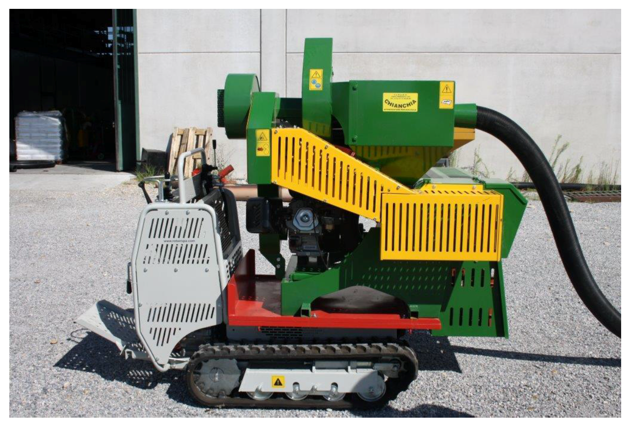
- Monarca, D.; Cecchini, M.; Colantoni, A.; Bedini, R.; Longo, L.; Bessone, W.; Caruso, L.; Schillaci, G. Evaluation of safety aspects for a small-scale machine for nuts harvesting. In Proceedings of the MECHTECH 2016 Conference—Mechanization and New Technologies for the Control and Sustainability of Agricultural and Forestry Systems, Alghero, Italy, 29 May–1 June 2016; pp. 32–35. [Google Scholar]
- Monarca, D.; Cecchini, M.; Massantini, R.; Antonelli, D.; Salcini, M.C.; Mordacchini, M.L. Mechanical harvesting and quality of “marroni” chestnut. Acta Horticulturae 2005, 682, 1193–1198. [Google Scholar] [CrossRef]
- Formato, A.; Scaglione, G.; Ianniello, D. Application of software for the optimization of the surface shape of nets for chestnut harvesting. J. Agric. Eng. 2013, 44. [Google Scholar] [CrossRef]
- Recanatesi, F.; Ripa, M.N.; Leone, A.; Luigi, P.; Luca, S. Land use, climate and transport of nutrients: Evidence emerging from the Lake Vicocase study. Environ. Manag. 2013, 52, 503–513. [Google Scholar] [CrossRef] [PubMed]
- Bilandzija, N.; Voca, N.; Kricka, T.; Matin, A.; Jurisic, V. Energy potential of fruit tree pruned biomass in Croatia. Span. J. Agric. Res. 2012, 10, 292–298. [Google Scholar]
- Cotugno, L. Territory and Population—Demographic Dynamics in Sicily. Rev. Hist. Geogr. Toponomast. 2011, 6, 81–91. [Google Scholar]
- Barbera, G.; Cullotta, S. An inventory approach to the assessment of main traditional landscapes in Sicily (Central Mediterranean Basin). Landsc. Res. 2012, 37, 539–569. [Google Scholar] [CrossRef]
- Colantoni, A.; Ferrara, C.; Perini, L.; Salvati, L. Assessing trends in climate aridity and vulnerability to soil degradation in Italy. Ecol. Indic. 2015, 48, 599–604. [Google Scholar] [CrossRef]
- Colantoni, A.; Delfanti, L.M.P.; Recanatesi, F.; Tolli, M.; Lord, R. Land use planning for utilizing biomass residues in Tuscia Romana (central Italy): Preliminary results of a multi criteria analysis to create an agro-energy district. Land Use Policy 2016, 50, 125–133. [Google Scholar] [CrossRef]
- Colantoni, A.; Longo, L.; Gallucci, F.; Monarca, D. Pyro-Gasification of Hazelnut Pruning Using a Downdraft Gasifier for Concurrent Production of Syngas and Biochar. Contemp. Eng. Sci. 2016, 9, 1339–1348. [Google Scholar] [CrossRef]
- Cecchini, M.; Monarca, D.; Colantoni, A.; Di Giacinto, S.; Longo, L.; Allegrini, E. Evaluation of biomass residuals by hazelnut and olive’s pruning in Viterbo area. In Proceedings of the International Commission of Agricultural and Biological Engineers, Section V. CIOSTA XXXV Conference “From Effective to Intelligent Agriculture and Forestry”, Billund, Denmark, 3–5 July 2013. [Google Scholar]
- Cerutti, A.K.; Beccaro, G.L.; Bagliani, M.; Donno, D.; Bounous, G. Multifunctional ecological footprint analysis for assessing eco-efficiency: A case study of fruit production systems in Northern Italy. J. Clean. Prod. 2013, 40, 108–117. [Google Scholar] [CrossRef]
- Gönenc, S.; Tanrıvermis, H.; Bülbül, M. Economic assessment of hazelnut production and the importance of supply management approaches in Turkey. J. Agric. Rural Dev. Trop. Subtrop. 2006, 107, 19–32. [Google Scholar]
- Petriccione, M.; Ciarmiello, L.F.; Boccacci, P.; De Luca, A.; Piccirillo, P. Evaluation of ‘Tonda di Giffoni’ hazelnut (Corylus avellana L.) clones. Sci. Horticult. 2010, 124, 153–158. [Google Scholar] [CrossRef]
- Di Giacinto, S.; Longo, L.; Menghini, G.; Delfanti, L.M.P.; Egidi, G.; De Benedictis, L.; Salvati, L. A model for estimating pruned biomass obtained from Corylus avellana L. Appl. Math. Sci. 2014, 8, 6555–6564. [Google Scholar] [CrossRef]
- Zambon, I.; Colosimo, F.; Monarca, D.; Cecchini, M.; Gallucci, F.; Proto, A.R.; Colantoni, A. An innovative agro-forestry supply chain for residual biomass: Physicochemical characterisation of biochar from olive and hazelnut pellets. Energies 2016, 9, 526. [Google Scholar] [CrossRef]


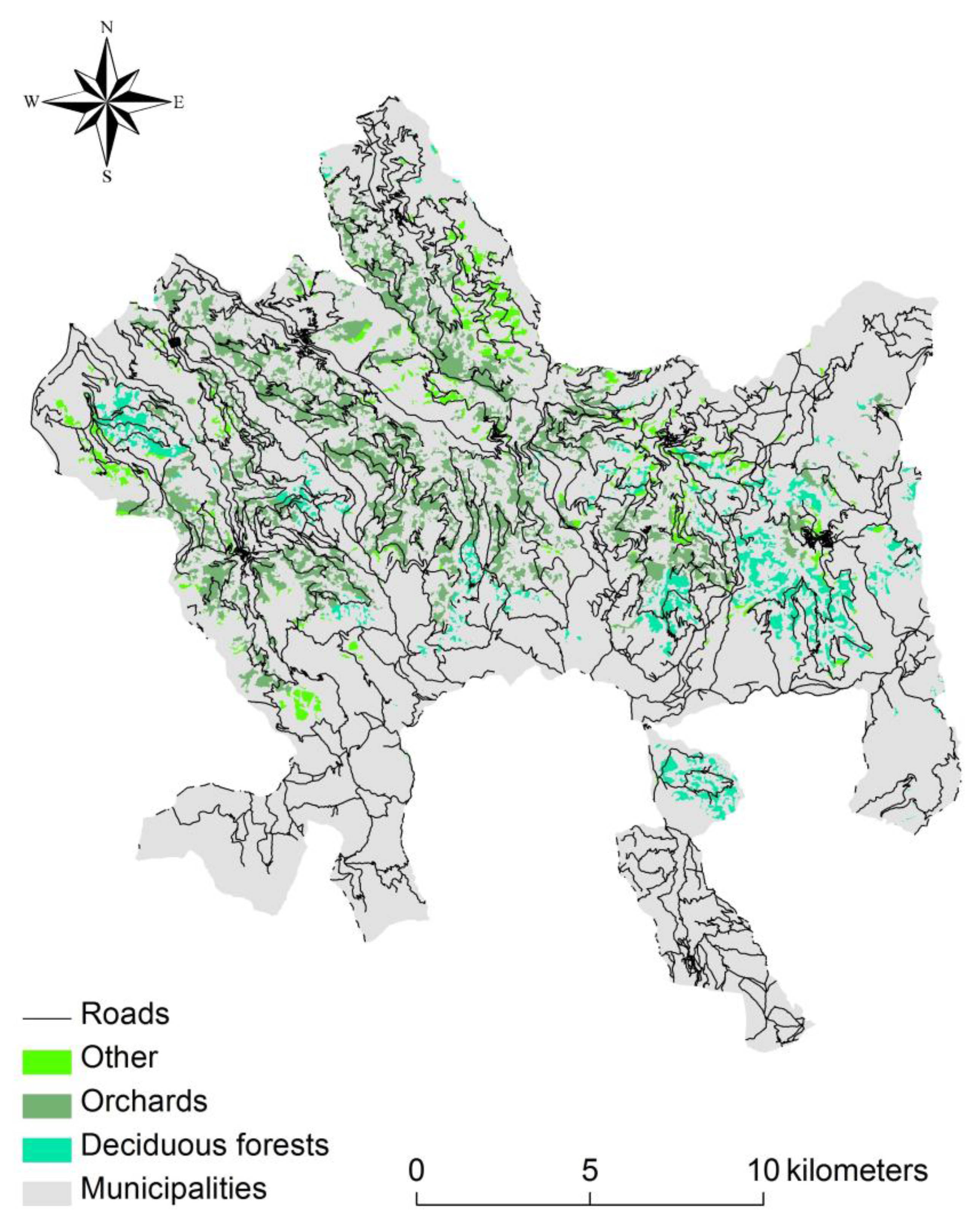
| Hectares of Hazelnuts Belonging to CLC Classes | Continuous Urban Fabric | Discontinuous Urban Fabric | Arable Crops in Non-Irrigated Areas | Orchards and Minor Fruits | Olive Grove | Annual Crops Associated with Permanent Crops | Complex Crop and Systems | Mainly Occupied Areas | Deciduous Forests | Areas with Natural Pasture at High Altitude | Areas Affected by Fires | Total of Hazelnuts |
|---|---|---|---|---|---|---|---|---|---|---|---|---|
| Code of CLC | 111 | 112 | 211 | 222 | 223 | 241 | 242 | 243 | 311 | 321 | 334 | |
| Castell’Umberto | 20.88 | 85.16 | 17.95 | 0.24 | 0.00 | 124.23 | ||||||
| Montalbano Elicona | 5.16 | 4.07 | 91.99 | 1.47 | 35.49 | 457.65 | 16.82 | 0.20 | 612.85 | |||
| Raccuja | 8.46 | 315.92 | 15.40 | 21.75 | 25.37 | 4.64 | 391.53 | |||||
| San Piero Patti | 3.32 | 7.21 | 423.81 | 66.77 | 91.16 | 205.15 | 17.86 | 815.28 | ||||
| San Salvatore di Fitalia | 14.49 | 65.52 | 5.07 | 19.72 | 2.50 | 138.41 | 43.77 | 289.47 | ||||
| Santa Domenica Vittoria | 118.95 | 0.00 | 118.95 | |||||||||
| Sant’Angelo di Brolo | 0.22 | 0.71 | 471.31 | 26.53 | 23.51 | 2.18 | 38.21 | 19.68 | 82.73 | 659.21 | ||
| Sinagra | 1.87 | 455.59 | 44.39 | 3.12 | 1.26 | 9.75 | 515.98 | |||||
| Tortorici | 11.97 | 0.47 | 669.69 | 0.56 | 92.44 | 63.45 | 838.59 | |||||
| Ucria | 7.17 | 535.19 | 0.19 | 1.63 | 54.85 | 4.32 | 603.35 | |||||
| Total | 3.54 | 70.00 | 12.45 | 3114.18 | 177.78 | 23.51 | 21.90 | 194.42 | 1114.00 | 243.33 | 0.20 | 4969.43 |
| 0% | 1% | 0% | 63% | 4% | 0% | 0% | 4% | 22% | 5% | 0% | 100% |
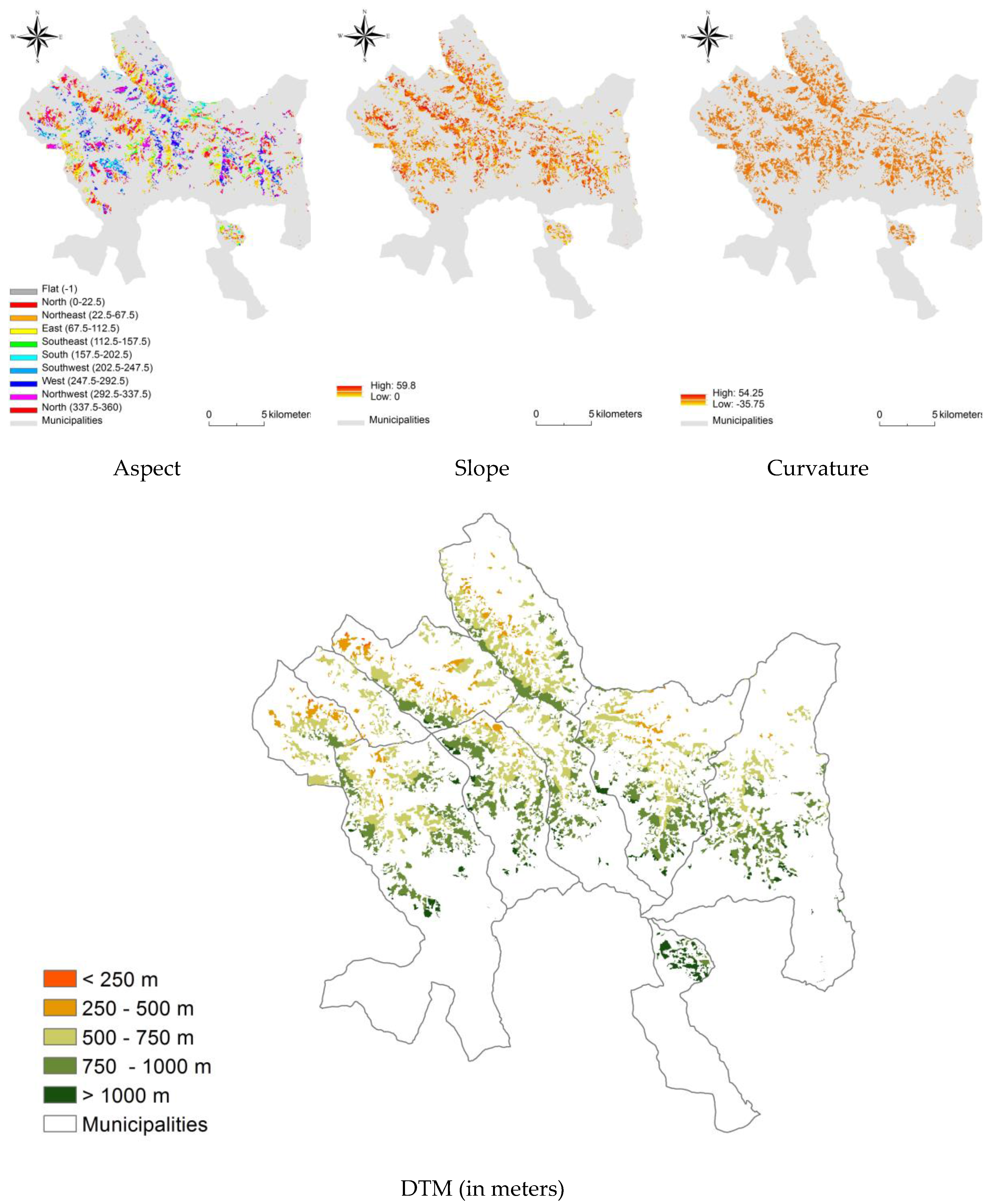
| DTM classes (meters) | ||||||
|---|---|---|---|---|---|---|
| <250 | 250–500 | 500–750 | 750–1000 | >1000 | % Area Compared to Total | |
| Castell’Umberto | 0.0 | 10.7 | 85.5 | 12.9 | 0.0 | 2% |
| Montalbano Elicona | 0.0 | 4.8 | 158.8 | 353.1 | 42.5 | 12% |
| Raccuja | 0.0 | 0.5 | 143.1 | 195.0 | 18.3 | 8% |
| San Piero Patti | 0.0 | 56.9 | 309.3 | 340.5 | 42.6 | 16% |
| San Salvatore di Fitalia | 3.1 | 71.1 | 149.1 | 45.3 | 0.0 | 6% |
| Santa Domenica Vittoria | 0.0 | 0.0 | 0.0 | 15.5 | 93.4 | 2% |
| Sant’Angelo di Brolo | 0.8 | 70.5 | 346.9 | 191.8 | 0.0 | 13% |
| Sinagra | 5.8 | 133.9 | 214.0 | 117.9 | 6.6 | 10% |
| Tortorici | 0.0 | 31.9 | 313.1 | 368.4 | 58.2 | 17% |
| Ucria | 0.0 | 24.9 | 173.0 | 317.6 | 43.3 | 12% |
| <250 (%) | 250–500 (%) | 500–750 (%) | 750–1000 (%) | >1000 (%) | Average DTM | |
| Castell’Umberto | 0% | 10% | 78% | 12% | 0% | 627 |
| Montalbano Elicona | 0% | 1% | 28% | 63% | 8% | 825 |
| Raccuja | 0% | 0% | 40% | 55% | 5% | 802 |
| San Piero Patti | 0% | 8% | 41% | 45% | 6% | 754 |
| San Salvatore di Fitalia | 1% | 26% | 56% | 17% | 0% | 595 |
| Santa Domenica Vittoria | 0% | 0% | 0% | 14% | 86% | 1088 |
| Sant’Angelo di Brolo | 0% | 12% | 57% | 31% | 0% | 671 |
| Sinagra | 1% | 28% | 45% | 25% | 1% | 614 |
| Tortorici | 0% | 4% | 41% | 48% | 8% | 779 |
| Ucria | 0% | 4% | 31% | 57% | 8% | 797 |
| 755 | ||||||
© 2017 by the authors. Licensee MDPI, Basel, Switzerland. This article is an open access article distributed under the terms and conditions of the Creative Commons Attribution (CC BY) license (http://creativecommons.org/licenses/by/4.0/).
Share and Cite
Zambon, I.; Delfanti, L.; Marucci, A.; Bedini, R.; Bessone, W.; Cecchini, M.; Monarca, D. Identification of Optimal Mechanization Processes for Harvesting Hazelnuts Based on Geospatial Technologies in Sicily (Southern Italy). Agriculture 2017, 7, 56. https://doi.org/10.3390/agriculture7070056
Zambon I, Delfanti L, Marucci A, Bedini R, Bessone W, Cecchini M, Monarca D. Identification of Optimal Mechanization Processes for Harvesting Hazelnuts Based on Geospatial Technologies in Sicily (Southern Italy). Agriculture. 2017; 7(7):56. https://doi.org/10.3390/agriculture7070056
Chicago/Turabian StyleZambon, Ilaria, Lavinia Delfanti, Alvaro Marucci, Roberto Bedini, Walter Bessone, Massimo Cecchini, and Danilo Monarca. 2017. "Identification of Optimal Mechanization Processes for Harvesting Hazelnuts Based on Geospatial Technologies in Sicily (Southern Italy)" Agriculture 7, no. 7: 56. https://doi.org/10.3390/agriculture7070056