A Geospatial Cyberinfrastructure for Urban Economic Analysis and Spatial Decision-Making

Abstract
:1. Introduction
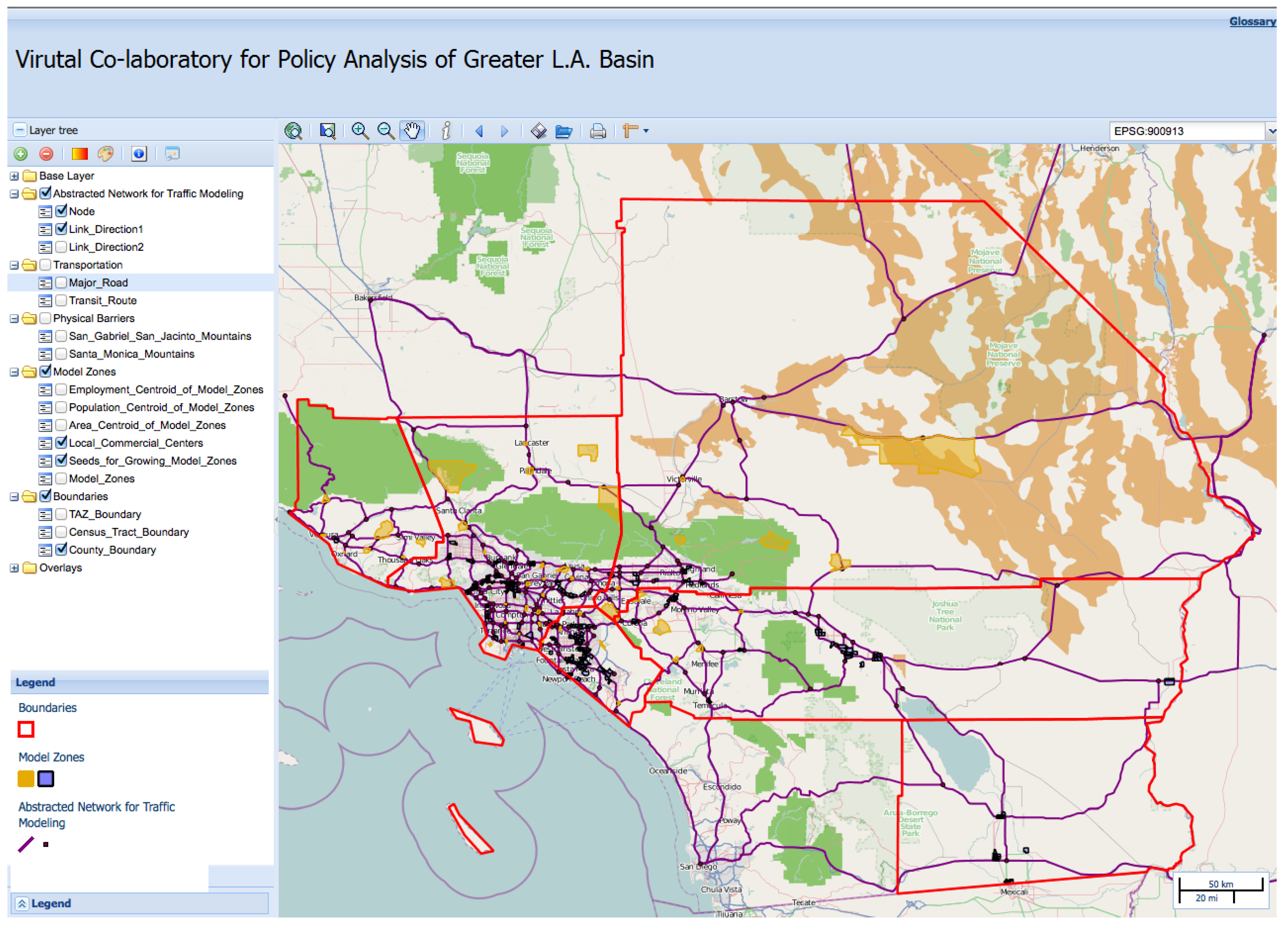
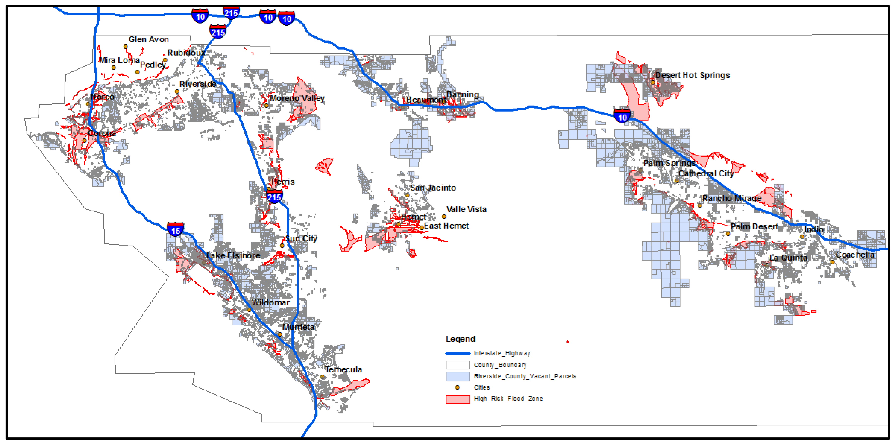
2. Planning Use Case
3. Literature
4. Methodology
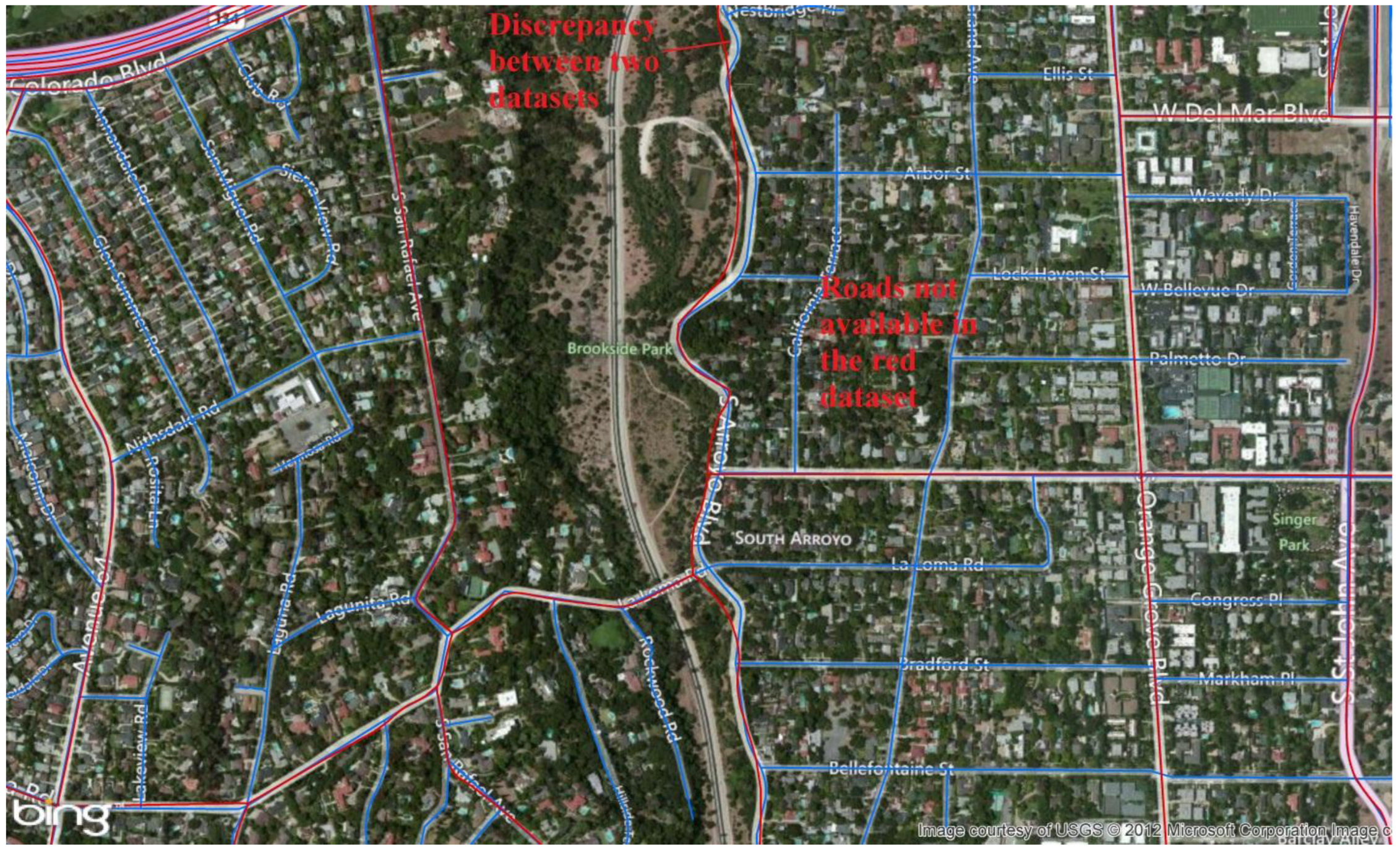
4.1. Conflation


 is the directed Hausdorff distance from feature i to feature j,
  is the dissimilarity between two feature names and a is a threshold beyond which two features are considered too far apart to be matched. The equations for calculating and are as follows:


 is the shortest distance between a point, x, on feature i and feature j,
  is the Hamming distance between the names of feature i and feature j, Li and Lj are the lengths of two feature names and α is a factor to normalize the name dissimilarity, so it is comparable with the directed Hausdorff distance, , when they are combined. The solution to the objective function (1) generates a matrix of zi→j, which gives all matched pairs of the features.
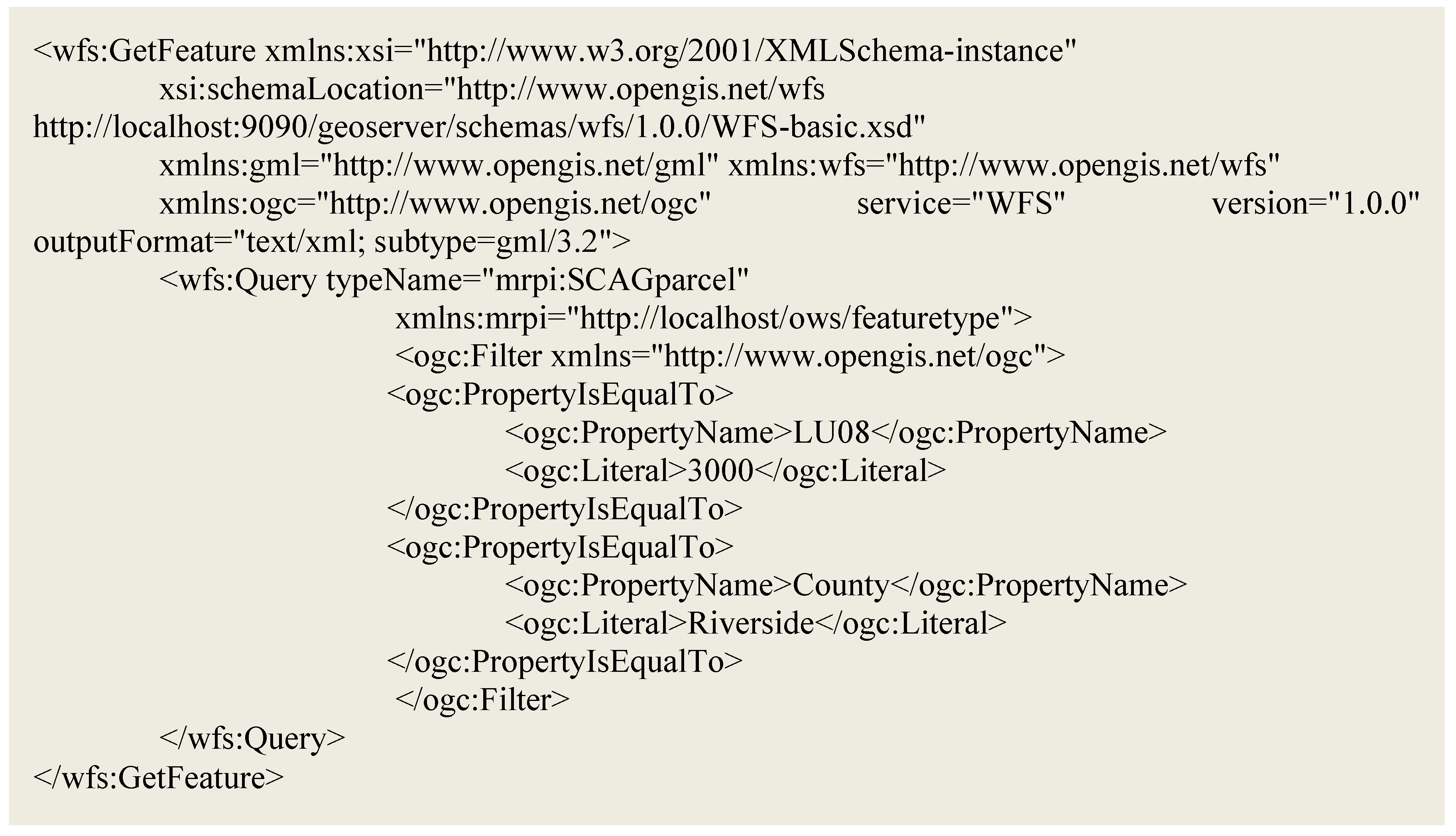
4.2. Service Chain of Geospatial Processes in the Service-Oriented GCI

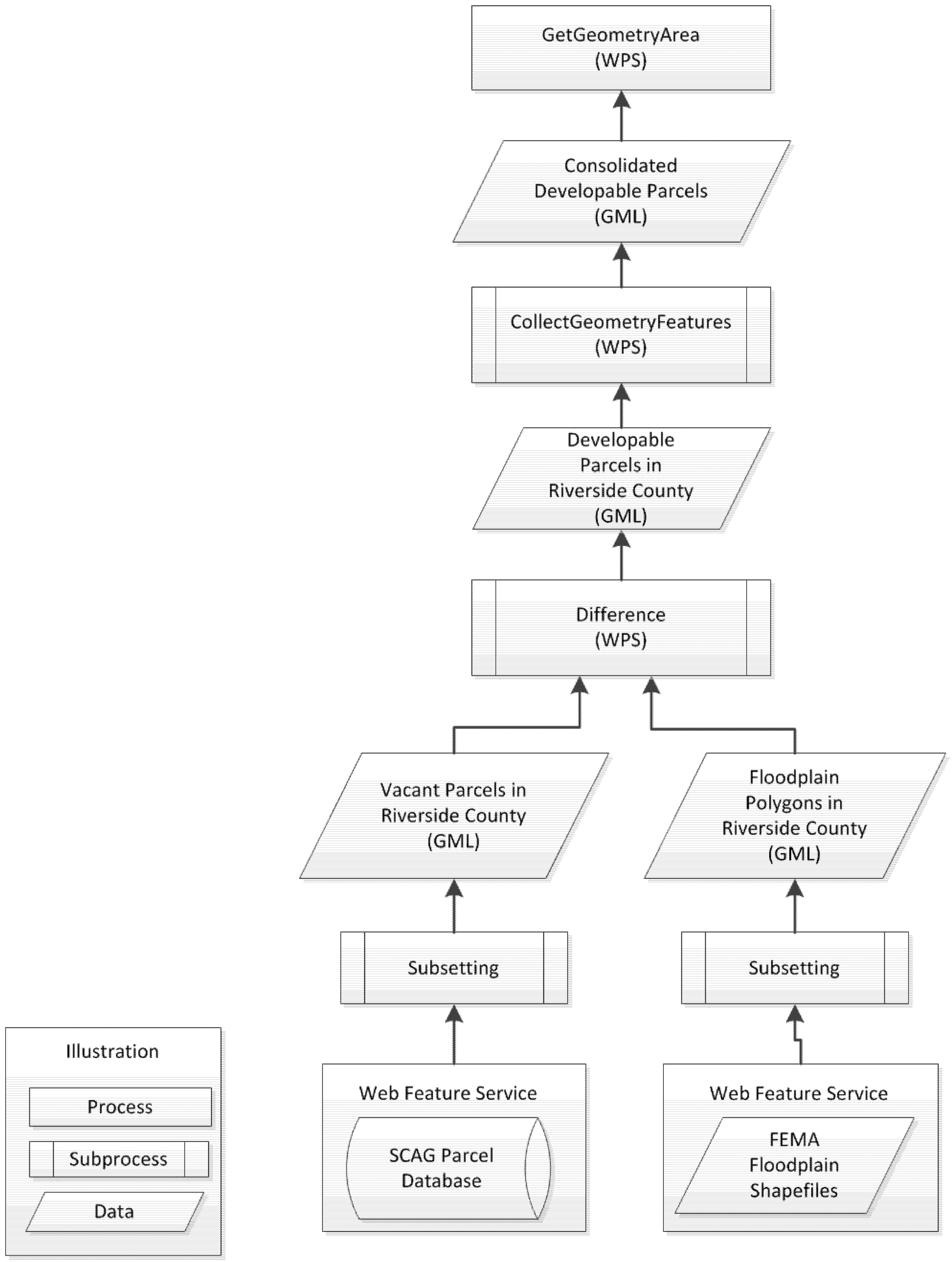

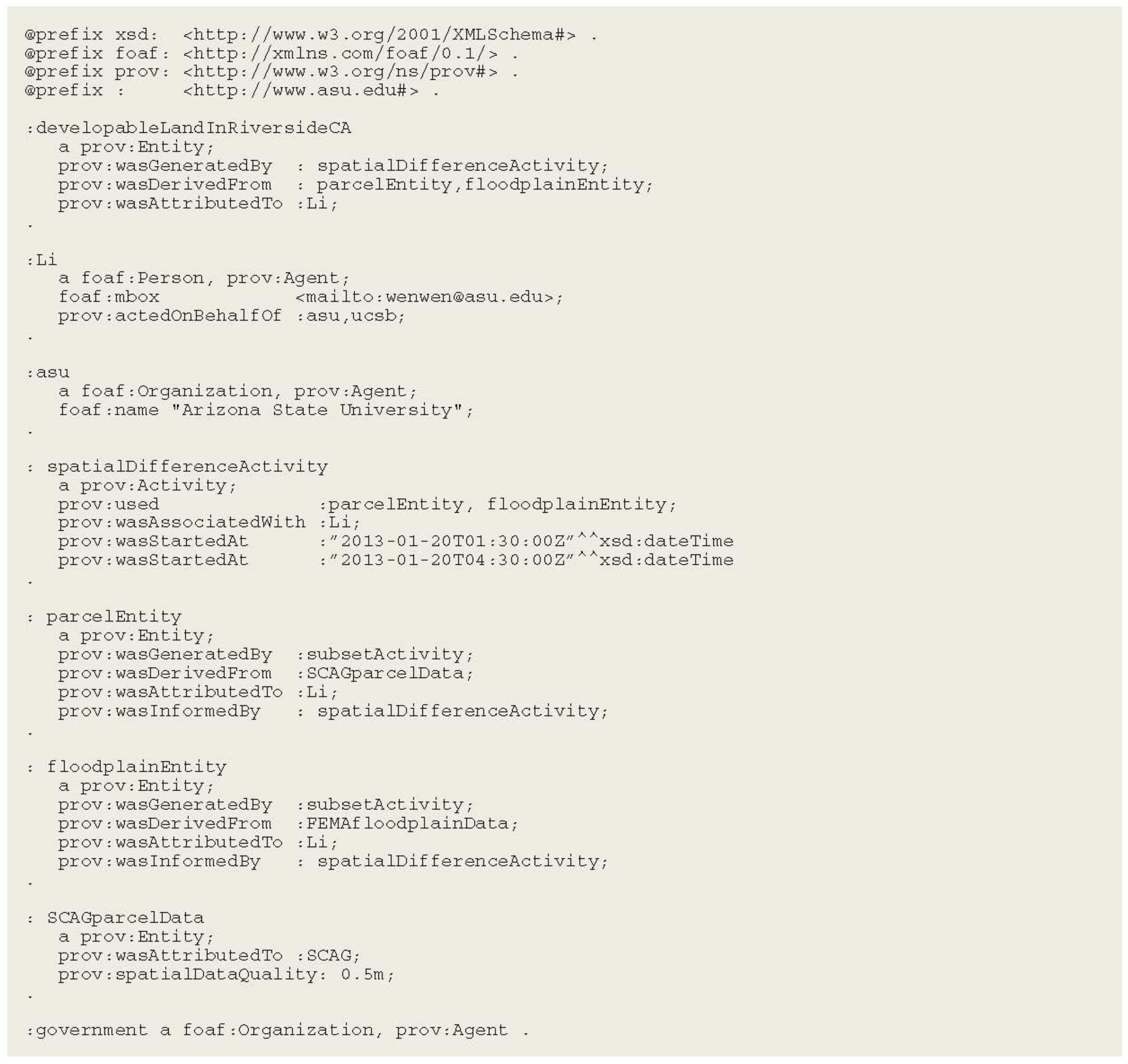
4.3. Data and Analytic Provenance

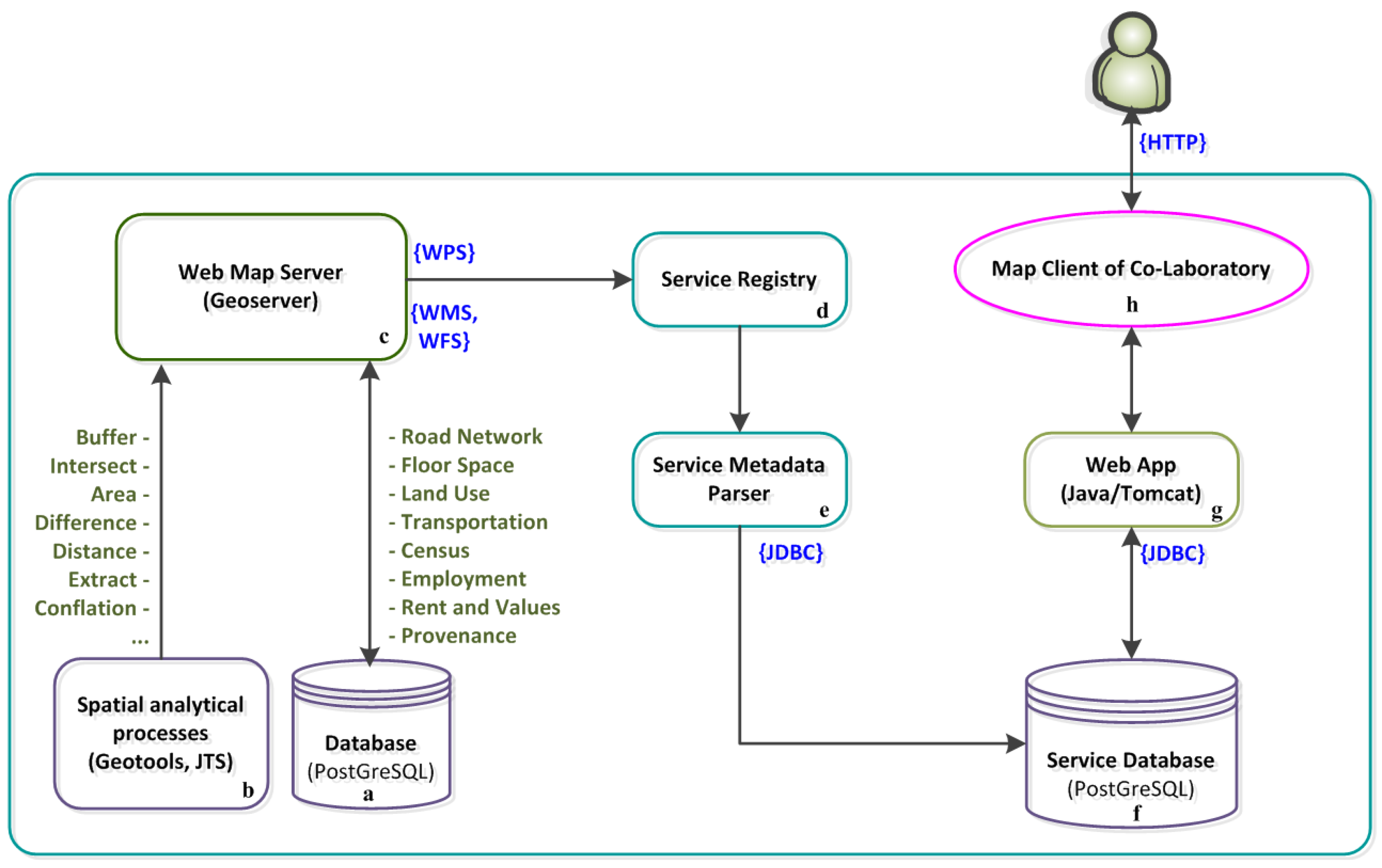
5. System Architecture of Urban GCI and Prototypes

6. Conclusions and Discussion
Acknowledgements
Conflict of Interest
References
- Hunt, J.C.; Maslin, M.; Killeen, T.; Backlund, P.; Schellnhuber, H.J. Introduction. Climate change and urban areas: Research dialogue in a policy framework. Phil. Trans. Roy. Soc. A-Math. Phy. 2007, 365, 2615–2629. [Google Scholar]
- Kelly, P.F. Everyday urbanization: The social dynamics of development in Manila’s extended metropolitan region. Int. J. Urban Reg. Res. 1999, 23, 283–303. [Google Scholar]
- Webster, D. Urbanization Dynamics and Policy Frameworks in Developing East Asia; East Asia Infrastructure Department Working Paper 2004; World Bank: Washington, DC, USA, 2004. [Google Scholar]
- Davoudi, S. Asymmetric Development in Spatial Planning: Positivist Content and Post-Modernist Processes? In Conceptions of Space and Place in Strategic Spatial Planning; Routledge: London, UK, 2009; pp. 207–244. [Google Scholar]
- Bollier, D.; Firestone, C.M. The Promise and Peril of Big Data; Aspen Institute, Communications and Society Program: Washington, DC, USA, 2010; p. 56. [Google Scholar]
- Antoniou, G.; van Harmelen, F. A Semantic Web Primer; MIT Press: Cambridge, USA, 2004; p. 264. [Google Scholar]
- Li, W.; Yang, C.; Yang, C. An active crawler for discovering geospatial web services and their distribution pattern—A case study of OGC Web Map Service. Int. J. Geogr. Inf. Sci. 2010, 24, 1127–1147. [Google Scholar]
- Atkins, D.; Droegemeier, K.; Feldman, S.; Garcia-Molina, H.; Klein, M.; Messerschmitt, D.; Messina, P.; Ostriker, J.; Wright, M. Revolutionizing Science and Engineering through Cyberinfrastructure; Report of the National Science Foundation Blue-Ribbon Advisory Panel on Cyberinfrastructure. NSF: Washington, DC, USA, 2003. Available online: http://www.nsf.gov/cise/ sci/reports/atkins.pdf (accessed on 12 May 2013).
- Yang, C.; Raskin, R.; Goodchild, M.; Gahegan, M. Geospatial cyberinfrastructure: Past, present and future. Comput. Environ. Urban Syst. 2010, 34, 264–277. [Google Scholar] [CrossRef]
- Anselin, L. From SpaceStat to CyberGIS: Twenty years of spatial data analysis software. Int. Reg. Sci. Rev. 2012, 35, 131–157. [Google Scholar] [CrossRef]
- Yang, C.; Li, W.; Xie, J.; Zhou, B. Distributed geospatial information processing: Sharing distributed geospatial resources to support Digital Earth. Int. J. Digit. Earth 2008, 1, 259–278. [Google Scholar] [CrossRef]
- Li, W.; Goodchild, M.F.; Anselin, L.; Weber, K. A Service-Oriented Smart CyberGIS Framework for Data-Intensive Geospatial Problems. In CyberGIS: Fostering a New Wave of Geospatial Discovery and Innovation; Wang, S., Goodchild, M.F., Eds.; Springer: New York, NY, USA, 2013; in press. [Google Scholar]
- Wright, D.J.; Wang, S. The emergence of spatial cyberinfrastructure. Proc. Nat. Acad. Sci. USA 2011, 108, 5488–5491. [Google Scholar] [CrossRef] [Green Version]
- Hey, T.; Trefethen, A.E. Cyberinfrastructure for e-science. Science 2005, 308, 817–821. [Google Scholar] [CrossRef]
- Goodchild, M.F.; Fu, P.; Rich, P. Sharing geographic information: An assessment of the Geospatial One-Stop. Ann. Assn. Amer. Geogr. 2007, 97, 250–266. [Google Scholar] [CrossRef]
- Beaumont, P.; Longley, P.A.; Maguire, D.J. Geographic information portals—A UK perspective. Comput. Environ. Urban Syst. 2005, 29, 49–69. [Google Scholar]
- Maguire, D.J.; Longley, P.A. The emergence of geoportals and their role in spatial data infrastructures. Comput. Environ. Urban Syst. 2005, 29, 3–14. [Google Scholar]
- Li, Z.; Li, W. Spatial Web Portal and Geobrowser. In Advanced Geoinformation Science; Yang, C., Wong, D., Miao, Q., Yang, R., Eds.; Taylor & Francis: Boca Raton, FL, USA, 2011; pp. 234–239. [Google Scholar]
- Carr, T.R.; Rich, P.M.; Bartley, J.D. The NATCARB geoportal: Linking distributed data from the carbon sequestration regional partnerships. J. Map Geogr. Libr. (Geoscapes.) 2007, 4, 131–147. [Google Scholar]
- Li, W.; Yang, C.; Nebert, D.; Raskin, R.; Houser, P.; Wu, H.; Li, Z. Semantic-based web service discovery and chaining for building an Arctic spatial data infrastructure. Comput. Geosci. 2011, 37, 1752–1762. [Google Scholar] [CrossRef]
- Goodchild, M.F. The Alexandria digital library project review, assessment, and prospects. Trend. Inf. Manage. (TRIM) 2005, 1, 20–25. [Google Scholar]
- Saalfeld, A. Conflation automated map compilation. Int. J. Geogr. Inf. Syst. 1988, 2, 217–228. [Google Scholar] [CrossRef]
- Li, L. Design of a Conceptual Framework and Approaches for Geo-Object Data Conflation. Ph.D. Thesis, University of California, Santa Barbara, CA, USA, 2010; p. 152. [Google Scholar]
- Samal, A.; Seth, S.; Cueto, K. A feature-based approach to conflation of geospatial sources. Int. J. Geogr. Inf. Sci. 2004, 18, 459–489. [Google Scholar] [CrossRef]
- Beeri, C.; Kanza, Y.; Safra, E.; Sagiv, Y. Object Fusion in Geographic Information Systems. In Proceedings of the Thirtieth International Conference on Very Large Data Bases, Toronto, ON, Canada, 29 August–3 September 2004; Volume 30, pp. 816–827.
- Li, L.; Goodchild, M.F. An optimisation model for linear feature matching in geographical data conflation. Int. J. Image Data Fusion 2011, 2, 309–328. [Google Scholar]
- Yang, P.; Li, W.; Xiao, D.; Raskin, R.; Bambacus, M. Earth information exchange: Sharing earth science information through interoperable approach and cyber infrastructure. Proc. SPIE 2007, 6753. [Google Scholar] [CrossRef]
- Li, W.; Yang, C.; Zhou, B.; Ren, Y.; Yang, C.; Yuan, L. Design and Implementation of an Integrated WMS Service Portal. In Proceedings of IEEE International Conference on Geoscience and Remote Sensing Symposium 2006 (IGARSS 2006), Denver, CO, USA, 31 July–4 August 2006; pp. 924–927.
- Sample, J.T.; Ladner, R.; Shulman, L.; Ioup, E.; Petry, F.; Warner, E.; Shaw, K.; McCreedy, F.P. Enhancing the US Navy’s GIDB portal with web services. IEEE Internet Comput. 2006, 10, 53–60. [Google Scholar] [CrossRef]
- Li, Z.; Yang, C.P.; Wu, H.; Li, W.; Miao, L. An optimized framework for seamlessly integrating OGC Web Services to support geospatial sciences. Int. J. Geogr. Inf. Sci. 2011, 25, 595–613. [Google Scholar] [CrossRef]
- Alameh, N. Service chaining of interoperable geographic information web services. Internet Comput. 2002, 7, 22–29. [Google Scholar] [CrossRef]
- Yue, P.; Gong, J.; Di, L. Augmenting geospatial data provenance through metadata tracking in geospatial service chaining. Comput. Geosci. 2010, 36, 270–281. [Google Scholar] [CrossRef]
- Lanter, D.P. Design of a lineage-based meta-data base for GIS. Cartogr. Geogr. Inform. Sci. 1991, 18, 255–261. [Google Scholar] [CrossRef]
- Lanter, D. GEOLINEUS: Data Management and Flowcharting for ARC/INFO; Technical Software Series S-92–2; National Center for Geographic Information and Analysis: Santa Barbara, CA, USA, 1992. [Google Scholar]
- Alonso, G.; Hagen, C. Geo-Opera: Workflow Concepts for Spatial Processes. In Advances in Spatial Databases; Springer: Berlin/Heidelberg, Germany, 1997; pp. 238–258. [Google Scholar]
- Frew, J.; Bose, R. Earth System Science Workbench: A Data Management Infrastructure for Earth Science Products. In Proceedings of the 13th International Conference on Scientific and Statistical Database Management, Fairfax, VA, USA, 18–20 July 2001; pp. 180–189.
- Frew, J.; Metzger, D.; Slaughter, P. Automatic capture and reconstruction of computational provenance. Concurr. Comput. Pract. Exp. 2008, 20, 485–496. [Google Scholar] [CrossRef]
- Wang, S.; Padmanabhan, A.; Myers, J.D.; Tang, W.; Liu, Y. In Towards Provenance-Aware Geographic Information Systems. In Proceedings of the 16th ACM SIGSPATIAL International Conference on Advances in Geographic Information Systems, Irvine, CA, USA, 5–7 November 2008; p. 70.
- Tilmes, C.; Fleig, A. Provenance Tracking in an Earth Science Data Processing System. In Provenance and Annotation of Data and Processes; Springer: Berlin/Heidelberg, Germany, 2008; pp. 221–228. [Google Scholar]
- Simmhan, Y.L.; Plale, B.; Gannon, D. A survey of data provenance in e-science. ACM Sigmod. Rec. 2005, 34, 31–36. [Google Scholar] [CrossRef]
- Li, L.; Goodchild, M.F. Automatically and accurately matching objects in geospatial datasets. Adv. Geo-Spat. Inf. Sci. 2012, 10, 71–79. [Google Scholar]
- De La Beaujardière, J. (Ed.) Web Map Service Implementation Specification; Open GIS Consortium Inc.: Washington, DC, USA, 2002; p. 82.
- Vretanos, P.A. (Ed.) Web Feature Service Implementation Specification; Open GIS Consortium Inc.: Washington, DC, USA, 2005; p. 94.
- Cox, S.; Cuthbert, A.; Daisey, P.; Davidson, J.; Johnson, S.; Keighan, E.; Lake, R.; Mabrouk, M.; Margoulies, S.; Martell, R. OpenGIS Geography Markup Language (GML) Implementation Specification, Version 2.1.2; Open GIS Consortium Inc.: Washington, DC, USA, 2002. [Google Scholar]
- Schut, P.; Whiteside, A. OpenGIS Web Processing Service; Open Geospatial Consortium: Wayland, MA, USA, 2007. [Google Scholar]
- Zhang, C.; Li, W. The roles of Web Feature and Web Map Services in real time geospatial data sharing for time-critical applications. Cartogr. Geogr. Inf. Sci. 2005, 32, 269–283. [Google Scholar] [CrossRef]
- Virtual Co-Laboratory for Policy Analysis of Greater L.A. Basin. Available online: http://mrpi.geog.ucsb.edu:8080/geonetwork/ (accessed on 13 May 2013).
- Anas, A.; Liu, Y. A regional economy, land use, and transportation model (RELU-TRAN): formulation, algorithm design and testing. J. Reg. Sci. 2007, 47, 415–455. [Google Scholar] [CrossRef]
- Li, W. Automated Data Discovery, Reasoning and Ranking in Support of Building an Intelligent Geospatial Search Engine. Ph.D. Thesis, George Mason University, Fairfax, VA, USA, 2010; p. 168. [Google Scholar]
- Li, W.; Goodchild, M.F.; Raskin, R. Towards geospatial semantic search: Exploiting latent semantic relations in geospatial data. Int. J. Digit. Earth 2012. [Google Scholar] [CrossRef]
- Li, W.; Raskin, R.; Goodchild, M.F. Semantic similarity measurement based on knowledge mining: An artificial neural net approach. Int. J. Geogr. Inf. Sci. 2012, 26, 1415–1435. [Google Scholar] [CrossRef]
- Li, W.; Yang, C.; Raskin, R. A Semantic Enhanced Search for Spatial Web Portals; AAAI Spring Symposium Technical Report, SS-08–05; AAAI: Palo Alto, CA, USA, 2008; pp. 47–50. [Google Scholar]
- Raskin, R.; Zhou, N.; Li, W. Geoinformation Knowledge Representation and Applications. In Advanced Geoinformation Science; Taylor and Francis: Boca Raton, FL, USA, 2011; pp. 276–299. [Google Scholar]
- Wu, H.; Li, Z.; Zhang, H.; Yang, C.; Shen, S. Monitoring and evaluating web map service resources for optimizing map composition over the internet to support decision making. Comput. Geosci. 2011, 37, 485–494. [Google Scholar] [CrossRef]
- Zhang, C.; Li, W.; Zhao, T. Geospatial data sharing based on geospatial semantic web technologies. J. Spat. Sci. 2007, 52, 35–49. [Google Scholar] [CrossRef]
- Zhang, C.; Zhao, T.; Li, W. The Framework of a geospatial semantic web based spatial decision support system for digital earth. Int. J. Digit. Earth 2010, 3, 111–134. [Google Scholar] [CrossRef]
© 2013 by the authors; licensee MDPI, Basel, Switzerland. This article is an open access article distributed under the terms and conditions of the Creative Commons Attribution license (http://creativecommons.org/licenses/by/3.0/).
Share and Cite
Li, W.; Li, L.; Goodchild, M.F.; Anselin, L. A Geospatial Cyberinfrastructure for Urban Economic Analysis and Spatial Decision-Making. ISPRS Int. J. Geo-Inf. 2013, 2, 413-431. https://doi.org/10.3390/ijgi2020413
Li W, Li L, Goodchild MF, Anselin L. A Geospatial Cyberinfrastructure for Urban Economic Analysis and Spatial Decision-Making. ISPRS International Journal of Geo-Information. 2013; 2(2):413-431. https://doi.org/10.3390/ijgi2020413
Chicago/Turabian StyleLi, Wenwen, Linna Li, Michael F. Goodchild, and Luc Anselin. 2013. "A Geospatial Cyberinfrastructure for Urban Economic Analysis and Spatial Decision-Making" ISPRS International Journal of Geo-Information 2, no. 2: 413-431. https://doi.org/10.3390/ijgi2020413