Conceptual Design of a Mobile Application for Geography Fieldwork Learning

Faculty of Geo-Information Science and Earth Observation (ITC), University of Twente, P.O. Box 217, 7500 AE Enschede, The Netherlands
*
Author to whom correspondence should be addressed.
ISPRS Int. J. Geo-Inf. 2017, 6(11), 355; https://doi.org/10.3390/ijgi6110355
Submission received: 30 August 2017
/
Revised: 3 October 2017
/
Accepted: 3 November 2017
/
Published: 9 November 2017
(This article belongs to the Special Issue Geospatial Applications, Tools and Location-Based Services for Education)
Abstract
:The use of mobile applications on smartphones has a vast potential to support learning in the field. However, all learning technologies should be properly designed. To this end, we adopt User-Centered Design (UCD) to design a mobile application, called GeoFARA (Geography Fieldwork Augmented Reality Application), for university geography fieldwork. This paper is about the conceptual design of GeoFARA based on its use and user requirements. The paper first establishes a review of selected existing mobile AR applications for outdoor use, in order to identify the innovative aspects and the improvements of GeoFARA. Thereafter, we present the results of use and user requirements derived from (1) an online survey of the current use of tools in undergraduate geography fieldwork, (2) a field experiment in which the use of paper maps and a mobile mapping tool were compared, (3) investigations during a human geography fieldwork, (4) post-fieldwork surveys among undergraduates from two universities, (5) our use case, and (6) a use scenario. Based on these requirements, a conceptual design of GeoFARA is provided in terms of technical specifications, main contents, functionalities, as well as user interactions and interfaces. This conceptual design will guide the future prototype development of GeoFARA.
1. Introduction
Fieldwork provides a real world context to geography education [1,2]. As such, fieldwork learning can bring students cognitive, affective and ethical benefits to produce deeper experiences of the fieldwork place(s) [3]. In this paper, we focus on higher educational fieldwork in real outdoor settings and we restrict our attention to the cognitive gains, i.e., developing comprehensive geographic understanding [4]. Our fieldwork context is that undergraduates explore a human geography theme (the influence of historical industrial factors on the current spatial structure) in an urban area (case study in Enschede, The Netherlands).
In order to improve and enhance fieldwork learning, the importance of field teaching and learning strategies has been highlighted by several authors, e.g., [5] (p. 189). Proposed and applied strategies include the appropriate design of the fieldwork e.g., [6,7], and the proper integration of technology e.g., [2,8]. Certainly, the technologies used in fieldwork and the ways of using them have been promoted by technological innovations. Amid those innovations, there have been significant advancements in mobile Information and Communication Technologies (ICTs) in terms of both software and hardware. Mobile ICTs have already been applied to assist fieldwork and are still under development [9]. However, little research has clearly demonstrated the adoption of the combined use of mobile ICTs in geography fieldwork, and for the available mobile tools used in geography fieldwork, there are hardly signs of the involvement of users in the design of the mobile tools. In this study, we focus on the combined use of the mobile interface technology Augmented Reality (AR), with other mobile ICTs, such as digital maps, through one mobile application. This is because AR can enable real-time location-based interactions [10] with additional device-generated contextual information (i.e., augmentations) embedded within the real world (i.e., reality). In addition, the combined use of AR and other sensor technologies on smartphones has considerable potential for supporting fieldwork [8]. This potential can be particularly seen in geography fieldwork that is naturally visual and relying heavily on geographical information.
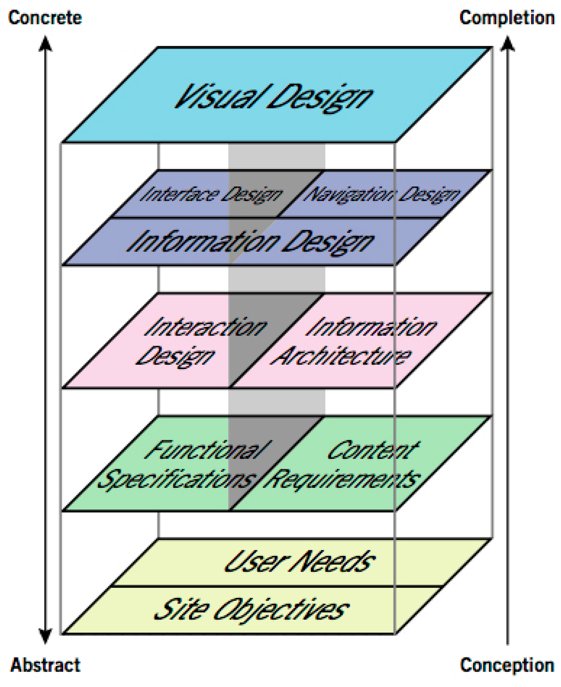
To design and develop a mobile fieldwork application with good usability supporting the specified context of a human geography fieldwork in an urban environment, the principle of User-Centered Design (UCD) should be applied. The goal of UCD is to improve the usability of the designed products by involving and centering users during the design process [11]. In this article, we focus on the conceptual design of a new mobile AR fieldwork application, called GeoFARA (Geography Fieldwork Augmented Reality Application). To conceptually design GeoFARA, we follow Garrett’s [12] model about “The Elements of User Experience” as Figure 1, since user experience is a broader concept including usability. This model can be used for user-centered designing the web and beyond, such as the mobile application in this paper. Garrett’s model breaks down design processes into five steps, from the basic plane - user needs and creator’s goals, to the ultimately visual design through three intermediate steps. These steps describe the design from the perspectives of both the information of a product, including content requirements, information architecture, navigation and information design (the right column of Figure 1) and the interaction with a product, including functional specifications, interaction design, interface design and information design (the left column of Figure 1). Applying Garrett’s model, the conceptual design of GeoFARA will be presented from an abstract level (use and user requirements) to a relatively concrete level (mainly interaction design and interface design).
In this paper, a review of selected research-based existing mobile AR applications is presented in Section 2. Section 3 presents the results of the analysis of user requirements collected from various sources. Thereafter, in Section 4 we describe the context of a specific human geography fieldwork as the use case for GeoFARA, in terms of the objectives, the questions that participants need to answer and the tasks to be executed in the fieldwork. To provide an example of future use situation with user actions, Section 5 gives a user scenario of GeoFARA. On the basis of all these requirements, in Section 6, we then present a concrete design of GeoFARA in terms of hardware and software specifications, main contents, functionalities, as well as interactions and interfaces. Lastly, Section 7 concludes by reflecting on the design process and indicating further research.
2. Mobile AR Applications for Outdoor Use
There is increasing attention and scientific literature on the use of mobile AR, supporting various field activities, such as field trips, outdoor navigation, tourism, etc. For the conceptual design of GeoFARA, it is first of all needed to examine the benefits and problems of existing mobile AR applications in their efforts to support outdoor activities. For this, we selected five existing mobile AR applications for outdoor use that have a comparable purpose to GeoFARA, i.e., assisting users to understand the geography of the fieldwork area during field activities.
2.1. Selection Criteria and Inventory
The final selection was based on more detailed criteria: (1) research-based mobile AR applications from scientific publications that are released after the year 2010; (2) supporting field (geo-) activities in urban areas; (3) using location-based techniques to align virtual information; (4) available on smartphones. Based on the criteria above, several examples were selected (Table 1) and further reviewed in terms of the used platform, purposes, interfaces, implementation and sources.
Example 1: HTT. Tsai and Huang [13] introduced the HTT (Historical Time Tunnel) system as a context-aware mobile AR learning platform. It was designed and implemented to support a field trip of exploring local monuments for culture courses through providing students with an immersive experience of disappeared or damaged historic attractions. The immersion was created through AR by augmenting real scenes with multimedia learning material of sounds, images, or video clips. A static field trip map indicating Point of Interests (POIs) was integrated as learning material in HTT. Tsai and Huang [13] tested the usability of HTT by comparing post-fieldwork questionnaires among the control group who conducted a traditional field trip and the experimental group who used the HTT. The results indicated that the HTT system provided a significant assistance to the novice teacher and can effectively boost students’ interest in fieldtrip exploration. Overall, the HTT system achieved the learning effect through interaction.
In the AR interface of HTT, 2D icons were used to overlay the multimedia contents, but overlaying 3D models of monuments was suggested, which is expected to further boost learning. Therefore, creating 3D models of some key buildings that are within the fieldwork area could be applied in the conceptual design of GeoFARA.
Example 2: ARLearn. The ARLearn system [14,15], developed by the Centre for Learning Sciences and Technologies of the Dutch Open University, is a tool suite providing different mobile AR experience for educational settings in the real world by using the multimedia capabilities and location-based service on smartphones. In ARLearn, map view was Google Maps with satellite image layer showing the user’s current location and ARLearn objects. In the research by [15], ARLearn was applied to support mobile location-based learning during a cultural sciences fieldwork in the city of Florence by augmenting the user’s location with audios. ARLearn also featured note-taking functionality, so that students can take pictures, record audios and publish annotations. An evaluation of ARLearn was conducted through questionnaires and analyzing the students’ collected notes. Overall, the students were positive on the use of ARLearn as a learning tool during the field trip. The tutor of the fieldwork confirmed that students’ post-fieldwork reports were more systematic than in fieldwork without this tool suite. These results positively support the idea of developing a mobile AR application such as GeoFARA to support location-based learning during fieldwork.
Example 3: AR@Melaka. AR@Melaka [16,17,18] is a mobile AR application to assist visitors to experience enjoyable informal learning while exploring the Melaka heritage sites in Malaysia. A conceptual model was proposed to guide the development of AR@Melaka. The model consisted of three main components: mobile AR technology, enjoyable informal learning, and the cultural heritage site. Following the model, four main user interfaces were designed: home page, search page, sign viewer page, and information menu page. The contents include profile, audio, map and multiple choice quiz of the Melaka heritage sites. An evaluation was carried out by asking respondents to use the application and fill in a questionnaire afterwards. The results showed that AR@Melaka was easy, fast, useful and helpful in gaining knowledge and supporting enjoyable informal learning. The conceptual model of AR@Melaka provides the basic elements (hardware, content, interface) that can also be applied in the conceptual design of GeoFARA.
Example 4: EcoMOBILE. In the research of [19], the project EcoMOBILE (Ecosystems Mobile Outdoor Blended Immersive Learning Environment) was introduced. EcoMOBILE combines an AR experience with the use of environmental probeware, an educational application, during a field trip to a local pond environment. The AR component in EcoMOBILE was created using the FreshAiR AR development platform [21]. “Triggers” are placed on a map of the physical setting and become accessible to students at the real location in the field. At a trigger location, students can interact with multimedia (including texts, images, audios, videos, 3D models and animations, and multiple-choice or open-ended questions) through an immersive AR experience. Students found that the use of AR supported their recognition of non-obvious or unseen factors as significant actors in ecosystem dynamics. The overall EcoMOBILE experience contributed to significant student learning gains.
Augmenting non-obvious or unseen elements into EcoMOBILE enhances students’ field learning. Therefore, the conceptual design of GeoFARA should also take consideration augmenting those hidden but important parts of the fieldwork area that students might miss during the field trip.
Example 5: MobiAR. MobiAR [20] is a mobile AR application, aiming at providing users with location-based and personalized information of an urban area. The AR interfaces of MobiAR are different in different scenarios. The target users can be anyone who is eager to discover more about some places in a city. MobiAR was evaluated in a scenario of field use in the city San Sebastian, Spain. Quantitative (questionnaires) and qualitative (interviews and observations) evaluation methods were implemented. The evaluation aspects included technology-related usability and ease of use of the application, the overall user interface, content quality, information structure and design, information-related usability and user satisfaction. In general, participants found MobiAR was a useful tool to display visual information.
In comparing the map view and the AR view of MobiAR, almost all the users found that the map view was more functional than the AR view during navigation. Therefore, it is better to design the navigation functionality of GeoFARA in the map view instead of the AR view.
2.2. Analysis of the Selected Mobile AR Applications and Potential Design Decisions for GeoFARA
The detailed analysis of the above mobile AR applications can lead to the potential design decisions for GeoFARA. In summary, the main characteristics of those mobile AR applications are: (1) in AR view, location-based information is overlaid on real time scenes with which users can interact to get further information; (2) map views are different: either static maps or mobile digital maps or just the satellite image layer of mobile maps; (3) all kinds of multimedia, such as textual information, images, audios and videos are integrated. However, some limitations were also identified. The design of GeoFARA should try to overcome those limitations. One of the very obvious limitations is that users were only involved in testing the usability of the already developed mobile AR applications instead of during the design stages. During the future design of GeoFARA, users will be involved within the design, development and usability evaluation stages. Another major limitation is that in the above mobile AR examples, map interfaces and AR interfaces are always separated and it is hard for users to have a whole urban area overview on a single screen at the same time. To overcome this limitation, the interface design of GeoFARA will try to better integrate map and AR interfaces, giving users both an overview and a live view of the fieldwork area at the same time. We argue that, in the conceptual design of GeoFARA, this will be innovative compared to those reviewed mobile AR applications, and it will be an improvement to apply the design decisions drawn from the reviewed existing mobile AR applications.
3. User Requirements
In order to further define the design goals and to specify the hardware, software, functionalities, interactions and interfaces of GeoFARA, the requirements of potential users should be identified as an important stage of UCD activities. To do so, both experimental and non-experimental investigations were executed to collect these user requirements: (1) an online survey about the current situation of using visual assistance tools; (2) a field experiment in which the use of paper map and a mobile mapping tool were compared during a geography trip; (3) investigations through questionnaires, interviews and observations in a human geography fieldwork of Beijing Normal University (BNU); (4) post-fieldwork surveys among undergraduates from BNU and Ghent University (GU).
3.1. Online Survey
The online survey was about the current situation of the use of visual assistance tools in undergraduate human geography fieldwork. It was conducted through Survey Monkey [22]. The invitation of this survey was sent to human geography fieldwork organizers/teachers. The results were threefold: the current use of visualization tools in human geography fieldwork, reasons of and problems with using them, opinions about alternative tools.
The survey results showed that teachers employed more traditional visualizations than modern ones, but they showed much interest in using the visual potentials (interactive and dynamic ones) in any stage of the human geography fieldwork. The biggest present problem was that the visualizations were too old and not so up-to-date. Some of the teachers’ opinions about alternative visual tools were:
- “Integrated system that can be both operated as a data logger and real-time visualization tool. It should be able to have a self-help component to understand how it works on the go.”
- “Would be helpful to make sure a variety of existing base maps—for example, satellite imagery/air photos, shaded relief, political units—could be turned on or off as students add their data (probably mostly vector features).”
- “Should augment reality; Allow text, sound, images i.e., geo-media, to be collected.”
- “Create 3D map for clarifying the student view.”
- “Open source, mobile device(s)/platforms, flexible to update, easy to use, customizable.”
User requirements can be derived from the results of opinions about alternative tools. These are: in GeoFARA, a clear description about how it works should be included; GeoFARA should provide different base maps of the fieldwork area; GeoFARA should enable collect all kinds of geo-media; GeoFARA should be easy-to-use and flexible-to-update.
3.2. Field Experiment
To find out the problems with the use of an existing mobile field application compared to the traditional paper maps, a field experiment [23] was carried out in Enschede, the Netherlands, by involving two groups of students in field mapping activities, one group (6 participants) using a paper map and the other group (6 participants) using the Locus mobile mapping application [24]. Locus was chosen mainly because it offers a variety of online maps and can be easily used in the field without Internet connection. Test persons’ mental maps before and after the field activities were analyzed to interpret their geographic understanding of the field experiment area. Most test persons drew point (such as big office buildings and shops) and line features (such as main roads, railway track) in their mental maps. We concluded that those drawn points and lines form the basic structure of the field area in the test persons’ minds. Therefore, to reinforce the impressions of the structure and enhance geographic understanding, augmenting both points and lines of interest through GeoFARA could offer the required visual support.
All the participants in two groups had post-mental maps that were substantially more detailed than the pre-mental maps. However, surprisingly, after the execution of the mapping task, the paper map group got a higher level of improvement in their geographic understanding of the study area compared to the Locus mapping application group. The main reason for this result was that the technical issues (such as unexpected system failures, faint screen, etc.) in using Locus distracted the test persons from learning the geography of the field area. Therefore, after the conceptual design, technical implementation of GeoFARA should be such that the amount of system failures is as little as possible.
3.3. Investigations during a Human Geography Fieldwork
Through a questionnaire survey, observations and interviews during a real educational human geography fieldwork executed by BNU in China in July 2015, it was investigated how teachers and students conduct their fieldwork, what difficulties they experience and what their expectations and suggestions are for a possible future mobile tool.
In total, 93 out of 100 students responded to the questionnaire survey. The students were doing a major in four different geo-related domains: geography science, GIS, urban planning, and land administration. The observation method was used in all three stages of the fieldwork, aiming at observing how teachers and students perform the teaching and learning activities. 9 students and 4 teachers were randomly chosen to attend the semi-structured interviews. Teachers were interviewed after they completed the field teaching tasks, while students were interviewed after the post-fieldwork task.
In terms of ownership of smartphones and tablets, from the survey it was found that all Chinese students had their own mobile phones. 64% of the mobile phone operating systems were Android and 32% of them were IOS. Therefore, using GeoFARA on participants’ smartphones is realistic and GeoFARA should consider supporting the operating systems of both IOS and Android, but developing for Android is a priority. In terms of the interface language of GeoFARA, supporting the English language will be considered first in view of the anticipated group of the later usability test persons and the fact that English is used as the communication language in this research. However, interfaces in the Chinese language would be possible as well to serve prospective Chinese users.
Further requirements collected from this human geography fieldwork were already reported on and justified in the publication of [25]. Here, they are summarized as:
- Integrate various visualizations (photos, old maps, mobile digital maps, satellite images) of the fieldwork area. This is for the purpose of making use of different visualizations to increase the users’ geographical understanding of the fieldwork area.
- Enable to collect various field data (through notes, voice, registration of field walking routes) with geo-locational details. All of those collected photos, notes and voice with geo-locational information can be shown through hyperlinks in the map view.
- Group interactions. When GeoFARA is used by multiple users, all users can share the current locations, photos, fieldwork progress etc. within the group. This is mainly for supporting group work during fieldwork.
- Location-based contents recommendations. GeoFARA provides information based on the user’s current location.
- Show readable contents on the screens of mobile phones. In GeoFARA, the scale of maps, the fonts in the text descriptions, the resolution and size of photos, etc. must be suitable for reading on smartphone screens.
- Offline use. GeoFARA should function well without Internet connection in the field.
3.4. Post-Fieldwork Surveys among Undergraduates from two universities
Post-fieldwork surveys about the use of mobile phones were conducted in online and paper formats among students of GU and BNU respectively at the end of 2015. The main objective of the GU human geography fieldwork was to recognize and compare the extent of gentrification of certain neighborhoods in Amsterdam, and the main objective of the BNU human geography fieldwork (different from the one in Section 3.3) was to learn about the urban space structure development of Beijing and its functional changes by finding out how the Qing Dynasty’s embassy area has developed into the current landscape over the past 150 years.
In total, 28 undergraduates from GU and 61 undergraduates from BNU responded to the post-fieldwork surveys. 69% and 72% GU and BNU students owned smartphones with Android operating system, respectively. 54% GU undergraduates and 50% BNU undergraduates used digital maps on their mobile phones during the fieldwork.
Therefore, Android should be the first consideration for the design of GeoFARA. About using maps, it appears to be very necessary to integrate digital maps as most students think that maps were useful in assisting them to complete the fieldwork tasks and to improve their overall geographic understanding. The common 2D traffic layer of digital maps in applications such as Google Maps, Bing Maps, etc. should be the default interface. One of the big problems for students to use digital maps in their fieldwork was the required Internet connection. Therefore, GeoFARA should preferably integrate offline maps of the fieldwork area. Next to using maps, taking photos was another main activity on the students’ mobile phones during their actual fieldwork. This means that it also appears to be useful to integrate the photo-taking functionality in the conceptual design of GeoFARA.
4. Use Case Requirements
The overview of existing mobile AR applications and the analysis of user requirements obtained from a field study already give insights into the basic design needs of GeoFARA. However, to enable GeoFARA to meet the specific fieldwork objectives, and to assist students to answer their fieldwork questions and conduct their fieldwork tasks, it is necessary to specify a future use case and a more detailed use scenario from which more use requirements can be specified.
As already mentioned above, the fieldwork context is higher education undergraduates who are exploring a human geography theme in an urban area. The specific use case of GeoFARA is an urban geography fieldwork in which the influence of historical industrial factors on the current spatial structure will be explored. The fieldwork area will be in the city of Enschede, the Netherlands. The spatial structure of this city is very much influenced by its industrial history (textile industry which has largely collapsed) and there are quite some visible remnants. We chose this case because urban geography, as a subfield of human geography, is the study of the attributes (e.g., structures, functions, evolutions) of urban places (towns and cities) from geographic perspectives. In addition, urban structures are the outcome of complex historical forces, and the key structures are associated with industrial-related factors [26].
4.1. Knowledge Objectives of the Future Fieldwork
Under the overall objective of improving the geographical understanding of an urban area, four sub-objectives can be defined, ranging from obtaining basic geographic knowledge to developing comprehensive geographic understanding. These sub-objectives are: (1) to find out the historical textile industry background of the urban area; (2) to obtain up-to-date geographic information about the urban area; (3) to identify the spatial structure of the urban area and relate it with the historical textile industry.
4.2. Questions to Be Answered during the Future Fieldwork
Fieldwork can be divided into three main stages: before fieldwork, during fieldwork, and after fieldwork. As an assisting tool, GeoFARA will focus on assisting fieldwork activities related with increasing the geographical understanding of the fieldwork area during the three stages. In each stage, some fieldwork questions (Table 2) should be answered to meet the fieldwork objectives. If the students are able to find the answers to these questions, it is expected that the educational objectives can be reached.
4.3. Fieldwork Tasks
The fieldwork tasks are presented in Table 3 as a “to-do-list”, giving participants instructions of how to find out the answers to the above questions, and indicating whether and how GeoFARA can assist with the completion of the fieldwork tasks.
In the future fieldwork as a use case, GeoFARA can and should support students in completing some of these fieldwork tasks in the following ways:
- I
- Enabling importing fieldwork required materials from a desktop-based platform.
- II
- Offering digital maps indicating user location and old maps in digital form.
- III
- Enabling making annotations on maps.
- IV
- Presenting the past of fieldwork area in the forms of old photos, texts, and old maps.
- V
- Indicating which architectures and infrastructures are textile industrial remnants and which are not in points or lines of interest.
- VI
- Recording textual, photo information with geolocation on digital maps.
- VII
- Enabling exporting collected data to a desktop-based platform.
5. Use Scenario
Use case descriptions such as the one above can be made more specific and concrete by creating scenarios of future use. In UCD, scenarios are stories of the users’ specific activities with user actions, including elements of the who, when, where, what, why and how [27]. Therefore, scenarios are usually written in a narrative form. Considering this and the human geography fieldwork setting of using GeoFARA, a use scenario with a persona is generated as below.
5.1. Persona
The scenario is that an undergraduate is executing urban geography fieldwork tasks in the city Enschede as described in the above use case. Here, a persona named Maria represents the user group of GeoFARA. Maria is a MSc student, enrolled in a geo-related educational program. She is going to attend a human geography fieldwork in an urban area in Enschede, and she is not yet familiar with Enschede.
5.2. Scenario Descriptions
Before the actual fieldwork takes place, Maria already acquainted herself with the objectives and the fieldwork tasks. She prepares all the fieldwork materials on a desktop computer and imports them from the computer into her mobile phone. She reads the fieldwork materials on her mobile phone and marks the potential textile industrial remnants on maps for checking and confirming during fieldwork.
Starting walking in the fieldwork area in Enschede, Maria takes out of her phone and checks the mobile map on it and finds her current location, the name of the road she is standing on, and which direction she will go. In addition, she also wants to have an overview of the fieldwork area.
Then she starts to walk and explore the field environment. During her walk, she sees some textile industry remnants and new constructions in the fieldwork area. For those within her range of vision, she wants to find out where they are on the digital map, and, in addition, she wants to read the introductions about the geographies and histories of those textile industry remnants, see how they looked. She also takes some photos and makes notes about the visible past industrial architectures and infrastructures on maps, and their current functions. Besides, in order to make a further decision on where to go next, she wants to check what is included in the rest of fieldwork area, outside her range of vision. After that decision, she wants to find out how to get to the next destination. When she arrives there, she repeats doing the same as how she conducted the field activities within her vision range before.
By the end of the fieldwork tour and after getting back from the field, for a reflection on the whole field trip and her post-fieldwork tasks, she again checks all the main roads, remnants and constructions that she has visited, as well as the data, such as photos and notes she has taken during the fieldwork. She also views the collected data on a desktop-based web map to complete the post-fieldwork tasks.
5.3. User Tasks and Requirements Derived from the Use Scenario
To complete the goals in this scenario, GeoFARA as a supportive tool could support users such as Maria during the actual fieldwork through the following steps:
- Step 1
- With the help of an up-to-date mobile map in GeoFARA, the user tries to orient himself or herself when first entering the fieldwork area and when walking around.
- Step 2
- The mobile map in GeoFARA has both a street layer and a satellite image layer. In both layers, the current location of the user will be shown. The user zooms in/ out the mobile map. In the AR view of GeoFARA, the points and lines of interest will be overlaid with information of old maps, and text and image information on the reality view through the camera when the user rotates his or her smartphone. From the combined AR view and map view, the user learns about the textile industry remnants and new constructions.
- Step 3
- The user switches between the AR view and the map view of GeoFARA.
- Step 4
- The user clicks on the points and lines of interests to get further textual and photo information and the route of how to reach such a point or line of interest.
- Step 5
- The user follows the route to walk from the current location to the next location.
- Step 6
- The user collects data such as photos, notes of textile industrial remnants.
- Step 7
- The map view shows where photos and notes of textile industrial remnants are collected.
The above steps include user tasks such as orientation, information acquisition, data collection and data export. In each of those tasks, the users can pose related questions. For example, in the user task of orientation, the user questions such as “where am I?” and “what is around me?” are very basic. For performing the task of data collection, the user questions that are posed may include “how to record text (photo) information of my current location?” Analyzing the user tasks from the perspective of the corresponding user questions gives a picture of how GeoFARA will actually be used. For being capable of supporting the user tasks and answering the user questions, the system and user requirements of GeoFARA can be formulated and specified below:
- (1)
- Importing data from a computer platform. Before the geography fieldwork, the users must be able to import fieldwork materials from a computer to prepare the fieldwork.
- (2)
- Registering, logging in and logging out. In the scenario, the collected data can be viewed on the smartphone as well as on a computer after fieldwork. This requires that users must be able to create a user account through GeoFARA, after which the user can choose to log in and out. With the same account, users are able to view the collected data on another platform.
- (3)
- Viewing information in various forms. First, users must be able to optionally view the street layer and the satellite image layer of digital maps. GeoFARA also must allow users to view old maps, and text and image information related to each point and line of interest in the AR view.
- (4)
- Suggesting a route to a point or line of interest. GeoFARA should support users to make a decision where to go next.
- (5)
- Collecting geo-referenced data and making annotations. The users must be able to take notes, photos and videos, and make annotations based on the current location. Further, GeoFARA must allow users to view the collected data.
- (6)
- Making use of the collected data. After the geography fieldwork, the users must be able to use the data collected through GeoFARA on a computer.
6. Conceptual Design
Conceptual design, an early stage in the whole design process, is important to understand the future product’s concepts, features, etc. before the detailed design and actual development. Here, based on the above gathered user requirements, we present the basic elements of the conceptual design of GeoFARA, including hardware and software specification, basic main contents, functionalities, as well as user interfaces and interactions.
6.1. Hardware and Software Specifications
As described above, the mobile devices that GeoFARA will be used and tested are smartphones. To enable GeoFARA to run, the basic requirements are that the smartphones should include camera, GPS, motion sensor (accelerometer), compass and Internet access. From the investigations in actual fieldworks with user groups, it became clear that this is realistic, as almost every fieldwork participant has a smartphone with these capabilities. In terms of the operating system of the smartphone, GeoFARA should run on an Android operating system and the version of Android should be at least the version 4.4, KitKat. Next to that, for the time being, GeoFARA will only support the English language.
6.2. Main Contents
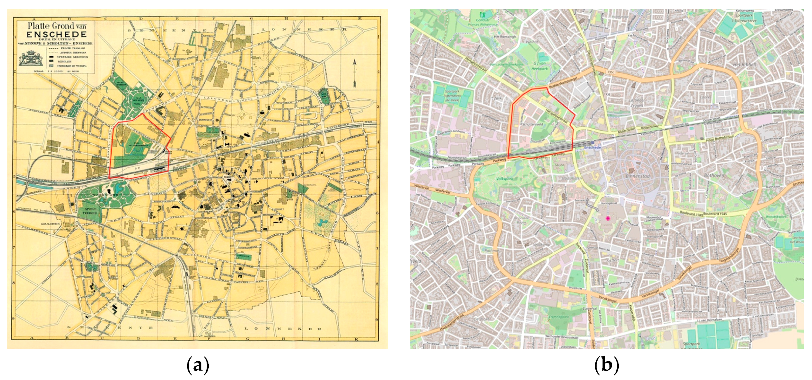
The main contents of GeoFARA can offer its users the information they need to meet the fieldwork objectives and to accomplish their fieldwork tasks. All user requirements need data support. For example, the requirement “optionally integrating various visualizations of the fieldwork area” involves data that GeoFARA needs to provide. Based on the user requirements, the main contents of GeoFARA are old maps (e.g., Figure 2a), digital maps which can show the user’s current location (Figure 2b, OpenStreetMap as an example), old and current photos of Enschede, as well as textual introduction about the fieldwork area and points and lines of interest. The selection of digital mobile maps will be mainly based on the possibilities of integration into a mobile application. In addition, the selection of textual introduction, photos and old maps should be clearly and closely related with the textile industry background of Enschede. Those data will be combined together with the interface technology (AR) of GeoFARA. For example, the textual introduction, old photos and maps can be presented in the augmentations through AR within GeoFARA.
6.3. Functionalities
Each product has its functionalities. In conceptual design, specifying functionalities can show how a product will support the user tasks. In UCD, the functionalities are derived from user requirements and will have the format of a systematic and detailed description of what the product should do [29].
After extracting the functional requirements based on the collected user requirements, the core functionalities of GeoFARA are summarized as:
- Overlaying both points and lines of interest through AR. POIs could be remnants of textile industrial architectures and infrastructures. Lines of Interest (LOIs) could be main roads and railway tracks within the fieldwork area.
- Displaying the POIs and LOIs on different layers of digital maps (indicating the user’s current location). In the AR view, users can also see the POIs and LOIs.
- Displaying detailed information when users click the POIs and LOIs. For a certain POI or LOI, the information could be textual introduction, old and new photos.
- Optionally viewing different layers of digital maps. The user can enable and disable to show a satellite image layer, or a 2D traffic layer.
- Offering navigation routes to POIs and LOIs. When users get detailed textual and visual information about a POI or a LOI, navigation routes are also suggested so that users know how to get there from the current location.
- Collecting field data (photos, videos and textual notes) with geo-details and making annotations on digital maps.
- Supporting group interaction. Users can contact each other to share their locations, photos, fieldwork progress, etc. anytime and anywhere when they conduct the fieldwork activities within the fieldwork area.
- Recommending location-based contents. The recommendations come from two sources: the system recommendations and other users’ recommendations about POIs and LOIs of the fieldwork area. This can show the hidden information that users might otherwise miss.
- Importing and exporting data between computers and GeoFARA. Users can import data from a computer to GeoFARA to prepare for the fieldwork and export data from GeoFARA to a computer to finish the post-fieldwork tasks respectively.
- Supporting offline mode. Before starting to use GeoFARA outdoor, users can make an option of offline using GeoFARA.
6.4. User Interfaces
Functionalities of a product can be performed through the interactions with it [29]. To show how users will interact with the product, user interfaces and interactions are important aspects of the conceptual design.
A software user interface is the front-end presentation layer of a software system. It shows the fundamental platform for user-software interactions. Software user interfaces can be in forms of texts, images and videos. In this conceptual design, user interfaces of GeoFARA are corresponding with the above core functionalities. Table 4 shows the details and explanations of the main user interfaces and interactions of GeoFARA.
7. Conclusions
In this paper, we presented a conceptual design of a mobile application with the purpose of assisting students to get a better geographical understanding of an urban area during human geography fieldwork. Methodologically, the conceptual design relies on theoretical and empirical groundings, for example, adopting the UCD approach, collecting user requirements in various scientific ways, and following Garrett’s “The Elements of User Experience” model. The aim of this conceptual design is to specify and visualize in what way the design of GeoFARA is based on the use and user requirements. In addition, this conceptual design is expected to be able to provide the guidelines for building a future prototype of GeoFARA.
The outcome of the conceptual design of GeoFARA was presented from the perspectives of hardware and software specifications, basic main contents, core functionalities, as well as core interfaces and interactions. The user interfaces of GeoFARA are in line with the core functionalities. Future research work will be on a working prototype development of GeoFARA based on the conceptual design presented in this paper, and then the evaluation of this prototype of GeoFARA. We are currently working on building an operational prototype of GeoFARA with sufficient functionalities and dynamic interactivities in a programming environment. During this process, we also make use of Android mobile application design guidelines and standards to ensure the consistency of the design of GeoFARA within mobile applications. As an important and essential part of UCD process, we are currently also evaluating the usability of GeoFARA with real users by combined using different methods and techniques such as mobile eye tracking, thinking aloud, task analysis, clickstream analysis, etc.
While this paper has demonstrated the conceptual design of GeoFARA for geography fieldwork learning, this application was designed only for smartphones running the Android operating system, not for other platforms such as IOS. To avoid such a cross-operating system issue, we would like to suggest a future research direction into responsive design that can be used on any mobile device regardless of the operation system.
Acknowledgments
This research work was supported by the Chinese Scholarship Council (CSC) and co-funded by Research Fund of Faculty of Geo-Information Science and Earth Observation (ITC), University of Twente. The authors are very thankful to Efiom Edem Ekpenyong who supported the field experiment in his MSc thesis research. The authors also greatly appreciate the help from Prof. Shangyi Zhou (Beijing Normal Unviersity), Prof. Ben Derudder (Ghent Univeristy) and. Jorn Koelemaij (Ghent Univeristy) for providing the chances of collecting data during their fieldwork. Many thanks also go to participants who gave valuable answers to the surveys and the interviews.
Author Contributions
This paper is part of Xiaoling Wang’s PhD research, under the supervision of Corné van Elzakker and Menno-Jan Kraak who gave suggestions and comments from conducing the research work to writing and finalizing this paper.
Conflicts of Interest
The authors declare no conflict of interest.
References
- Petcovic, H.L.; Stokes, A.; Caulkins, J.L. Geoscientists’ Perceptions of the Value of Undergraduate Field Education. GSA Today 2014, 24, 4–10. [Google Scholar] [CrossRef]
- Jarvis, C.; Tate, N.; Dickie, J.; Brown, G. Mobile Learning in a Human Geography Field Course. J. Geogr. 2016, 115, 61–71. [Google Scholar] [CrossRef]
- Israel, A.L. Geographies of Learning: Place, Space, and Embodied Experience in Higher Education Field Courses. Master’s Thesis, The Pennsylvania State University, State College, PA, USA, August 2009. [Google Scholar]
- Shin, E. Using Geographic Information System (GIS) Technology to Enhance Elementary Students’ Geographic Understanding. Theory Res. Soc. Educ. 2007, 35, 231–255. [Google Scholar] [CrossRef]
- Foskett, N. Teaching and Learning through Fieldwork. In Teaching and Learning in Geography; Tilbury, D., Williams, M., Eds.; Routledge: London, UK, 1997; pp. 189–201. [Google Scholar]
- Marvell, A.; Simm, D.; Schaaf, R.; Harper, R. Students as scholars: Evaluating Student-led Learning and Teaching during Fieldwork. J. Geogr. High. Educ. 2013, 37, 547–566. [Google Scholar] [CrossRef]
- Remmen, K.B.; Frøyland, M. Implementation of Guidelines for Effective Fieldwork Designs: Exploring Learning Activities, Learning Processes, and Student Engagement in the Classroom and the Field. Int. Res. Geogr. Environ. Educ. 2014, 23, 103–125. [Google Scholar] [CrossRef]
- Welsh, K.E.; Mauchline, A.L.; Park, J.R.; Whalley, W.B.; France, D. Enhancing Fieldwork Learning with Technology: Practitioner’s Perspectives. J. Geogr. High. Educ. 2013, 37, 399–415. [Google Scholar] [CrossRef]
- France, D.; Whalley, W.B.; Mauchline, A.; Powell, V.; Welsh, K.; Lerczak, A.; Park, J.; Bednarz, R.S. Enhancing Fieldwork Learning Using Mobile Technologies, 1st ed.; Springer International Publishing: Basel, Switzerland, 2015. [Google Scholar]
- Azuma, R. A Survey of Augmented Reality. Presence: Teleoperators Virtual Environ. 1997, 6, 355–385. [Google Scholar] [CrossRef]
- Thimbleby, H. Understanding User Centered Design (UCD) for People with Special Needs. In Computers Helping People with Special Needs; Miesenberger, K., Klaus, J., Zagler, W., Karshmer, A., Eds.; Springer: Berlin/Heidelberg, Germany, 2008; pp. 1–17. [Google Scholar]
- Garrett, J.J. The Elements of User Experience: User-Centered Design for the Web and Beyond, 2nd ed.; New Riders Publishing: Thousand Oaks, CA, USA, 2015; Available online: http://dl.acm.org/citation.cfm?id=1965524 (accessed on 30 August 2017).
- Tsai, C.H.; Huang, J.Y. A Mobile Augmented Reality Based Scaffolding Platform for Outdoor Fieldtrip Learning. In Proceedings of the 2014 IIAI 3rd International Conference on Advanced Applied Informatics, Kita-Kyushu, Japan, 31 August–4 September 2014. [Google Scholar]
- Ternier, S.; Klemke, R.; Kalz, M.; Specht, M. ARLearn: Augmented Reality Meets Augmented Virtuality. J. Univers. Comput. Sci. 2012, 18, 2143–2164. [Google Scholar] [CrossRef]
- Ternier, S.; De Vries, F.; Børner, D.; Specht, M. Mobile Augmented Reality with Audio. In Information Technology and Open Source: Applications for Education, Innovation, and Sustainability. Lecture Notes in Computer Science; Cerone, A., Persico, D., Fernandes, S., Garcia-Perez, A., Katsaros, P., Shaikh, S.A., Stamelos, I., Eds.; Springer: Berlin, Germany, 2014; pp. 53–63. [Google Scholar]
- Pendit, U.C.; Zaibon, S.B.; Abubakar, J.A.; Ntroduction, I. User Experience on Enjoyable Informal Learning via Mobile AR: Development and Evaluation. Int. J. Interact. Digit. Media 2014, 2, 29–34. Available online: http://ijidm.org/wp-content/uploads/2014–2-2–6-Ulka.pdf (accessed on 30 August 2017).
- Pendit, U.C.; Zaibon, S.B.; Abubakar, J. Conceptual Model of Mobile AR for Cultural Heritage Site towards Enjoyable Informal Learning. J. Teknol. 2015, 77, 123–129. [Google Scholar] [CrossRef]
- Zaibon, S.B.; Pendit, U.C.; Aida, J.; Bakar, A. Applicability of Mobile Augmented Reality Usage at Melaka Cultural Heritage Sites. In Proceedings of the 5th International Conference on Computing and Informatics, Istanbul, Turkey, 11–13 August 2015; Available online: http://www.icoci.cms.net.my/proceedings/2015/PDF/PID144.pdf (accessed on 30 August 2017).
- Kamarainen, A.M.; Metcalf, S.; Grotzer, T.; Browne, A.; Mazzuca, D.; Tutwiler, M.S.; Dede, C. EcoMOBILE: Integrating Augmented Reality and Probeware with Environmental Education Field Trips. Comput. Educ. 2013, 68, 545–556. [Google Scholar] [CrossRef]
- Linaza, M.; Marimon, D.; Carrasco, P.; Alvarez, C.; Montesa, J.; Aguilar, J.; Diez, G. Evaluation of Mobile Augmented Reality Applications for Tourist Destinations. In Information and Communication Technologies in Tourism 2012; Fuchs, M., Ricci, F., Cantoni, L., Eds.; Springer: Vienna, Austria, 2012; pp. 260–271. [Google Scholar]
- FreshAiR. Available online: http://www.playfreshair.com (accessed on 30 August 2017).
- The Online Survey. Available online: https://www.surveymonkey.com/s/5MW37Q9 (accessed on 30 August 2017).
- Wang, X.; Ekpenyong, E.E.; van Elzakker, C.P.J.M.; Kraak, M.J. Investigations into the Use of Cartographic Visualizations in Geography Fieldwork. In Proceedings of the ICC 2015 27th International Cartographic Conference, Rio de Janeiro, Brazil, 23–28 August 2015; Available online: http://www.icc2015.org/abstract%2c528.html (accessed on 30 August 2017).
- Locus Map. Available online: http://www.locusmap.eu (accessed on 30 August 2017).
- Wang, X.; van Elzakker, C.P.J.M.; Kraak, M.J. User Requirements Analysis for a Mobile Augmented Reality Tool supporting Geography Fieldwork. In Progress in Cartography: EuroCarto 2015; Gartner, G., Jobst, M., Huang, H., Eds.; Springer International Publishing: Basel, Switzerland, 2016; pp. 433–450. [Google Scholar]
- Hall, T.; Barrett, H. Urban Geography, 4th ed.; Routledge: New York, NY, USA, 2012. [Google Scholar]
- Lin, C.; Okamoto, M. The Method of User’s Requirement Analysis by Participation of the User: Constructing an Information System for Travelers. In Proceedings of the 1st International Conference on Human Centered Design, San Diego, CA, USA, 19–24 July 2009. [Google Scholar]
- Enschede in Ansichten. Available online: http://www.enschedeinansichten.nl/kaart1923.htm (accessed on 29 June 2017).
- Soares, M.D.S.; Vrancken, J.; Verbraeck, A. User Requirements Modeling and Analysis of Software-intensive Systems. J. Syst. Softw. 2011, 84, 328–339. [Google Scholar] [CrossRef]
Figure 1.
The elements of user experience for conceptual design (Adapted from [12]).
Figure 1.
The elements of user experience for conceptual design (Adapted from [12]).

Figure 2.
An old map (a) (adapted from [28]) and a digital map (b) of the fieldwork area within the city Enschede (the red line shows the boundary of the fieldwork area).
Figure 2.
An old map (a) (adapted from [28]) and a digital map (b) of the fieldwork area within the city Enschede (the red line shows the boundary of the fieldwork area).

Table 1.
Overview of the reviewed mobile AR applications.
| Application | Platform | Main Purpose | Main Interface Characteristic | Source |
|---|---|---|---|---|
| Example 1: HTT | Smartphone (Android and IOS) | To assist in a field trip for exploring local monuments for culture courses | On the AR view user interface, there is an arrow directing to a closest historic attraction to the user’s location. | Tsai and Huang, 2014 [13] |
| Example 2: ARLearn | Smartphone (Android) | To provide mobile AR experience for educational settings in the real world, such as a field trip | There are four main interfaces: map view, list view, item view and recording view. | Ternier et al., 2012 [14], 2014 [15] |
| Example 3: AR@Melaka | Smartphone (Android and IOS) | To assist informal learning in the Melaka heritage sites in Malaysia | Live/AR view and content view are the main interfaces. Live view shows the nearby historical sites based on the user’s location. | Pendit et al., 2014 [16], 2015 [17] Zaibon et al., 2015 [18] |
| Example 4: EcoMOBILE | Smartphone (Android and IOS) | To enhance understanding a local ecosystem during environmental educational field trips | The AR program helps in delivering navigation guide, introductory information, instructions, immediate feedback, etc. | Kamarainen et al., 2013 [19] |
| Example 5: MobiAR | Smartphone (Android) | To provide users with location-based and personalized information of an urban area | There are different kinds of POIs overlaid on the AR view. Users can access to the multimedia information (photos, videos, etc.) related to a certain POI. | Linaza et al., 2012 [20] |
Table 2.
Questions that need to be answered under the fieldwork objectives.
|
| 1. What were the geographical factors related with the origins of the main textile industries? 2. Where were the textile industrial architectures and infrastructures located? |
|
| 1. Are the past industrial textile architectures and infrastructures still visible now? 2. Which architectures and infrastructures can be directly related with the past textile industry? 3. What are the current functions of those architectures and infrastructures? 4. What are the distributions of those still visible textile industrial architectures and infrastructures? 5. Which architectures and infrastructures are new comparing to those past textile industrial ones? 6. What are the current functions of those textile industrial architectures and infrastructures? 7. Which main roads or railways or waterways can be directly related with the past textile industry? |
|
| 1. What are the distributions of past industrial architectures and infrastructures? 2. What are the road, railway and waterway patterns from the textile industry past till now? 3. How is the current spatial structure shaped by the main textile industrial architectures and infrastructures, road and railway and waterway network? 4. To what degree has the urban spatial structure changed from the textile industry past till now? 5. To what degree did the historical textile industry development influence the present spatial structure? 6. What evidences are there for those influences? |
Table 3.
Fieldwork tasks to be executed and how GeoFARA can assist.
| Stage | Fieldwork Tasks | The Role of GeoFARA * |
|---|---|---|
| Before |
| I |
| II | |
| II, III | |
| II, III | |
| During |
| II, IV, V |
| IV, V | |
| IV, V | |
| VI | |
| ||
| VI | |
| After |
| VII |
| ||
| ||
|
* I, II… indicate how GeoFARA can assist as listed below.
Table 4.
User interfaces and interactions of GeoFARA and descriptions.
| Interface Name | User Interfaces and Interactions, and Their Descriptions |
|---|---|
| Start page, AR view, and data collection |  |
| |
| Map view; Data collection with geo-details; Group interaction; |  |
| |
| AR and map view page; Information display page; |  |
|
© 2017 by the authors. Licensee MDPI, Basel, Switzerland. This article is an open access article distributed under the terms and conditions of the Creative Commons Attribution (CC BY) license (http://creativecommons.org/licenses/by/4.0/).
Share and Cite
MDPI and ACS Style
Wang, X.; Van Elzakker, C.P.J.M.; Kraak, M.-J. Conceptual Design of a Mobile Application for Geography Fieldwork Learning. ISPRS Int. J. Geo-Inf. 2017, 6, 355. https://doi.org/10.3390/ijgi6110355
AMA Style
Wang X, Van Elzakker CPJM, Kraak M-J. Conceptual Design of a Mobile Application for Geography Fieldwork Learning. ISPRS International Journal of Geo-Information. 2017; 6(11):355. https://doi.org/10.3390/ijgi6110355
Chicago/Turabian StyleWang, Xiaoling, Corné P. J. M. Van Elzakker, and Menno-Jan Kraak. 2017. "Conceptual Design of a Mobile Application for Geography Fieldwork Learning" ISPRS International Journal of Geo-Information 6, no. 11: 355. https://doi.org/10.3390/ijgi6110355
Note that from the first issue of 2016, this journal uses article numbers instead of page numbers. See further details here.