Land-Use Suitability in Northeast Iran: Application of AHP-GIS Hybrid Model

 ,
,  ,
, 
Abstract
:1. Introduction
2. Methodology
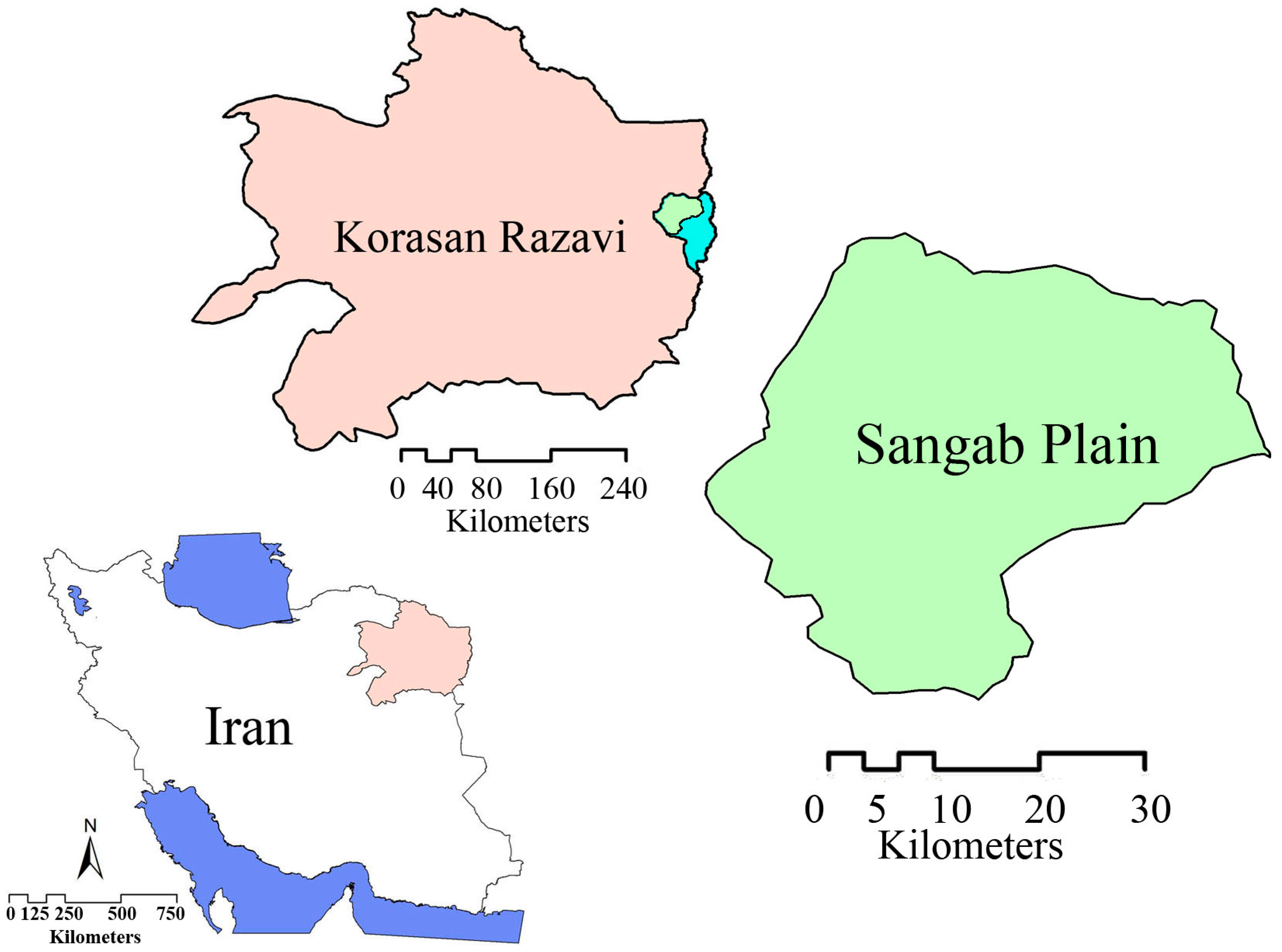
2.1. Data
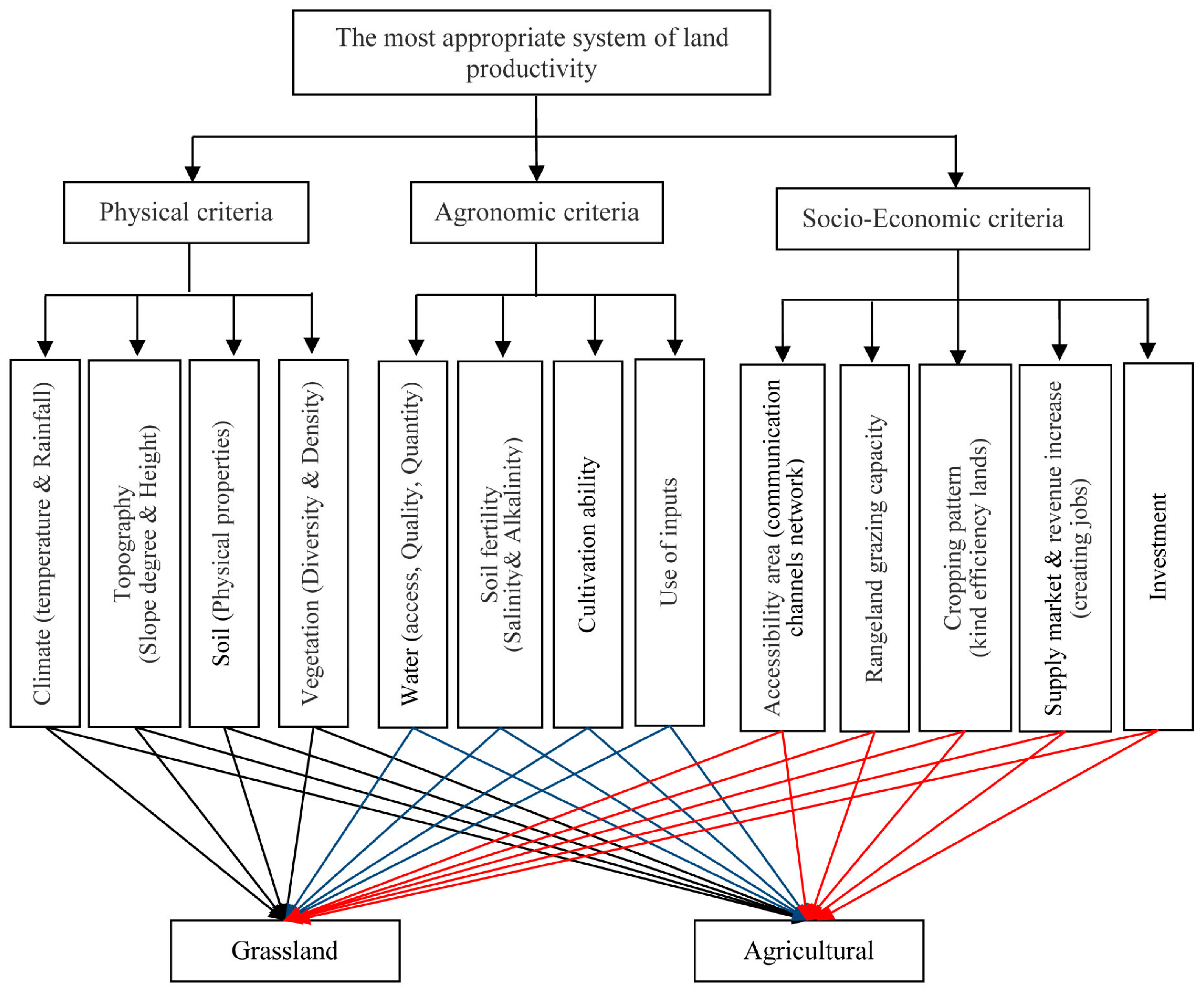
2.2. Analytic Hierarchy Process (AHP)
2.3. Geographic Information System (GIS)
2.4. Ecological Models
3. Results
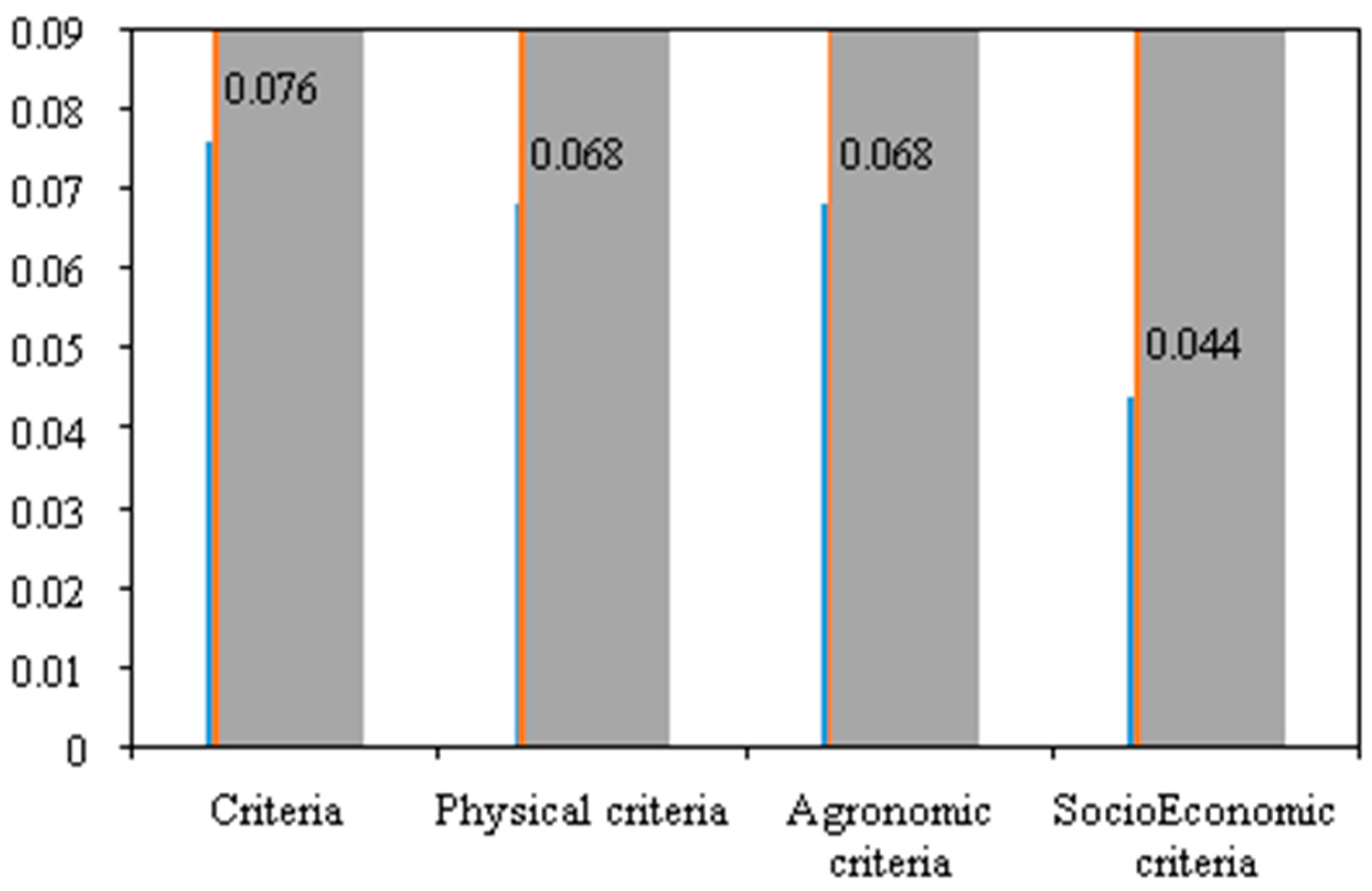
3.1. AHP Weights
3.2. Spatial Analyses
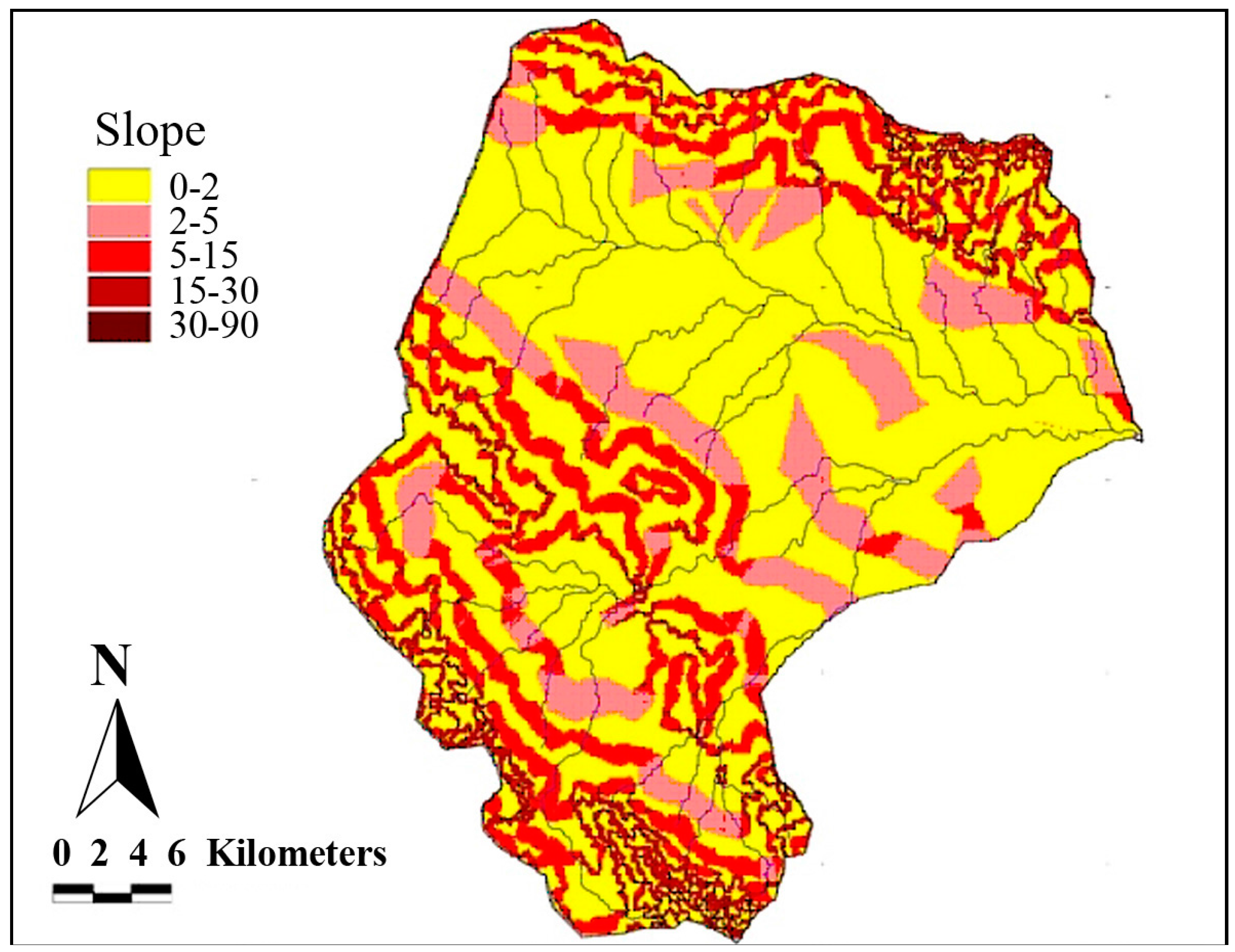
3.2.1. Slope
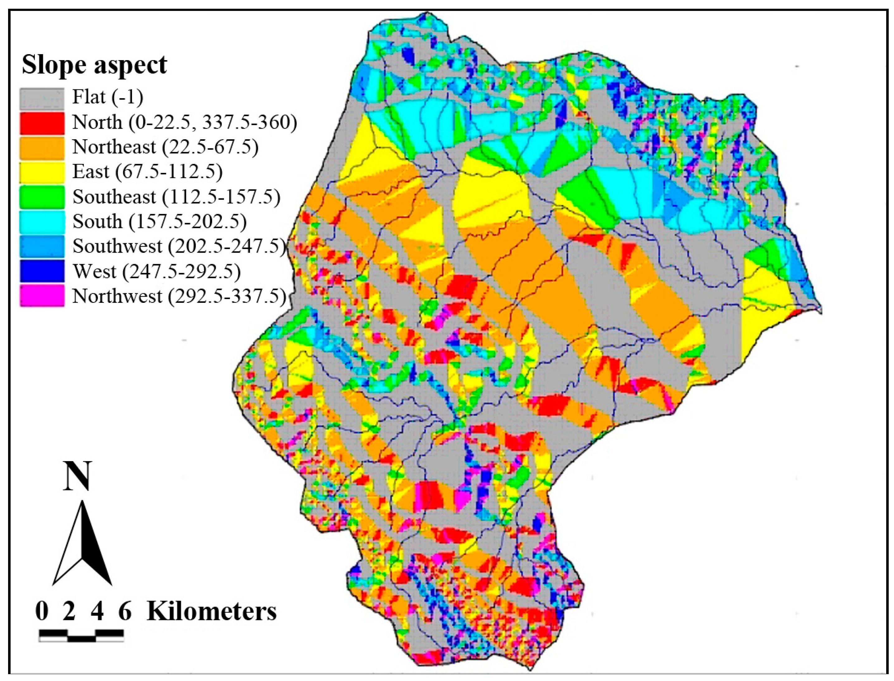
3.2.2. Slope Aspect
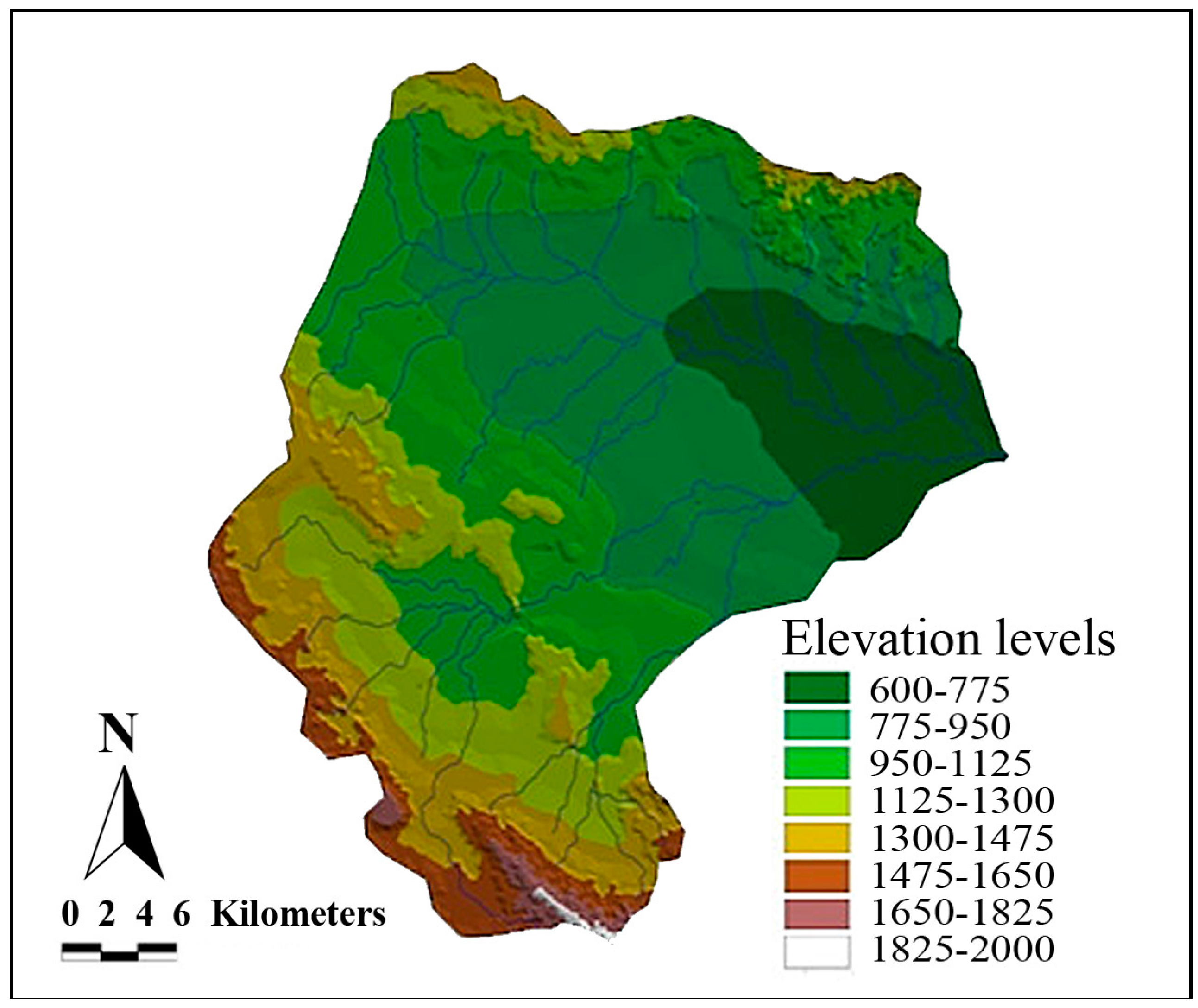
3.2.3. Elevation
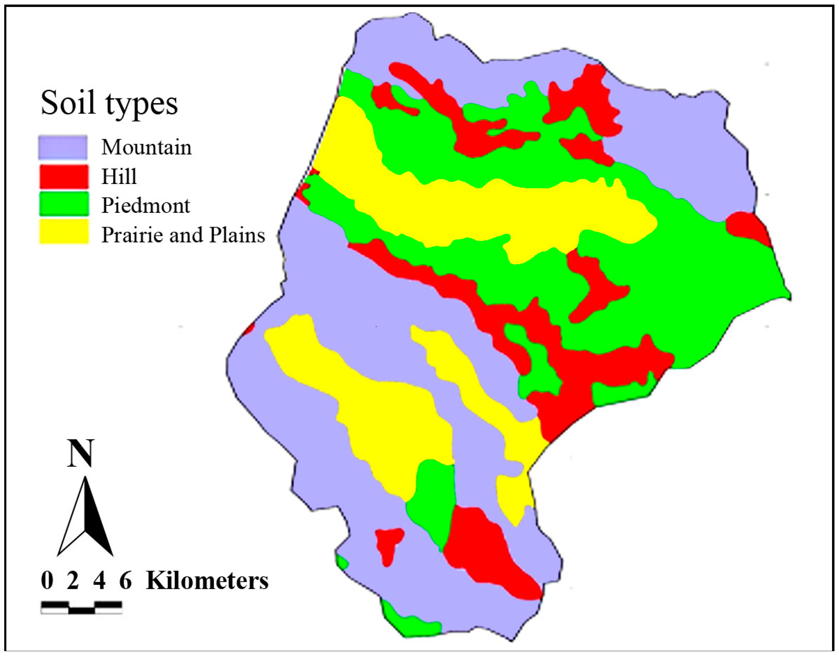
3.2.4. Soils
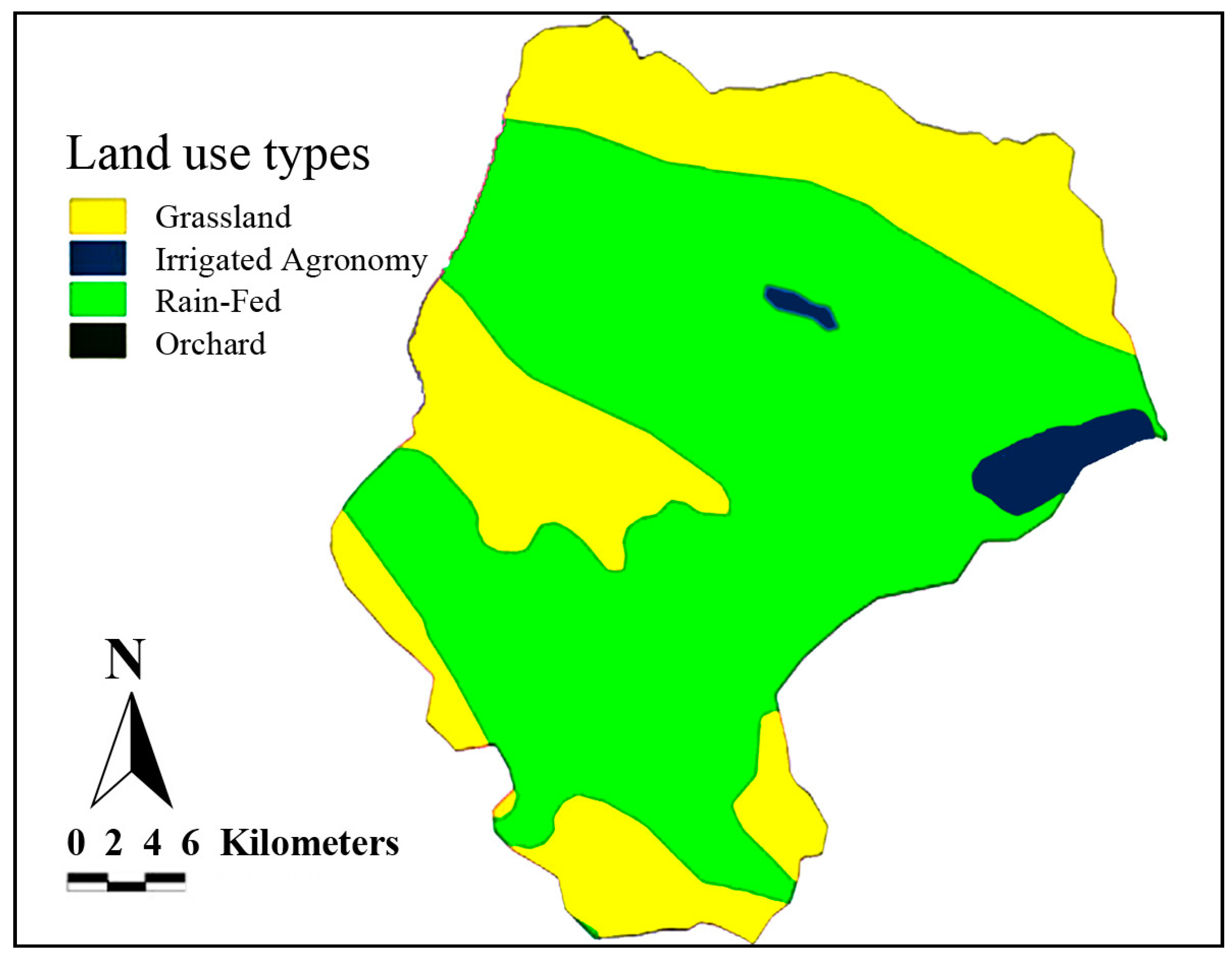
3.2.5. Land Use
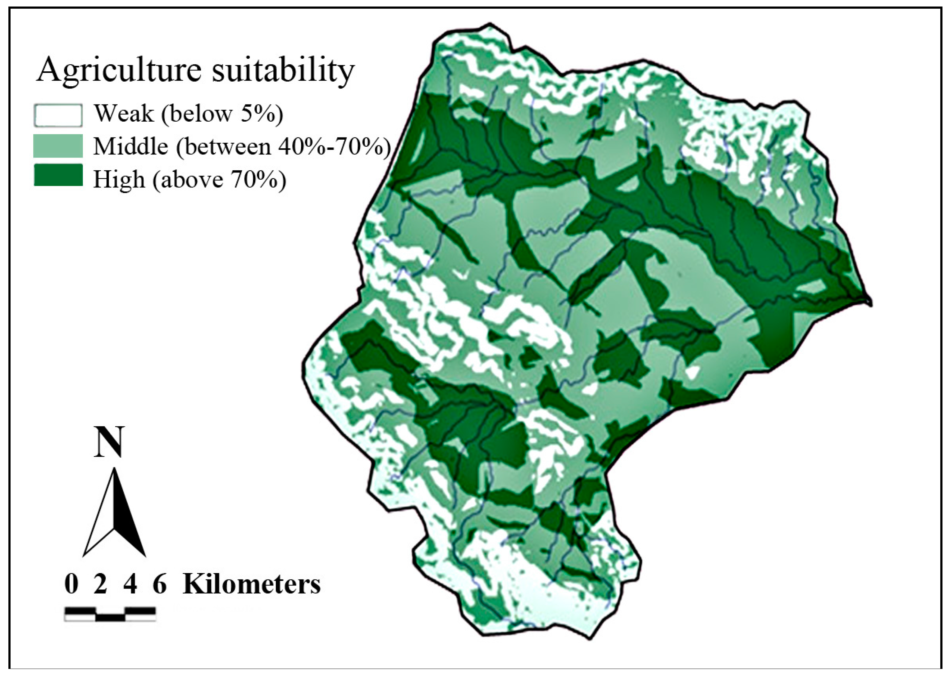
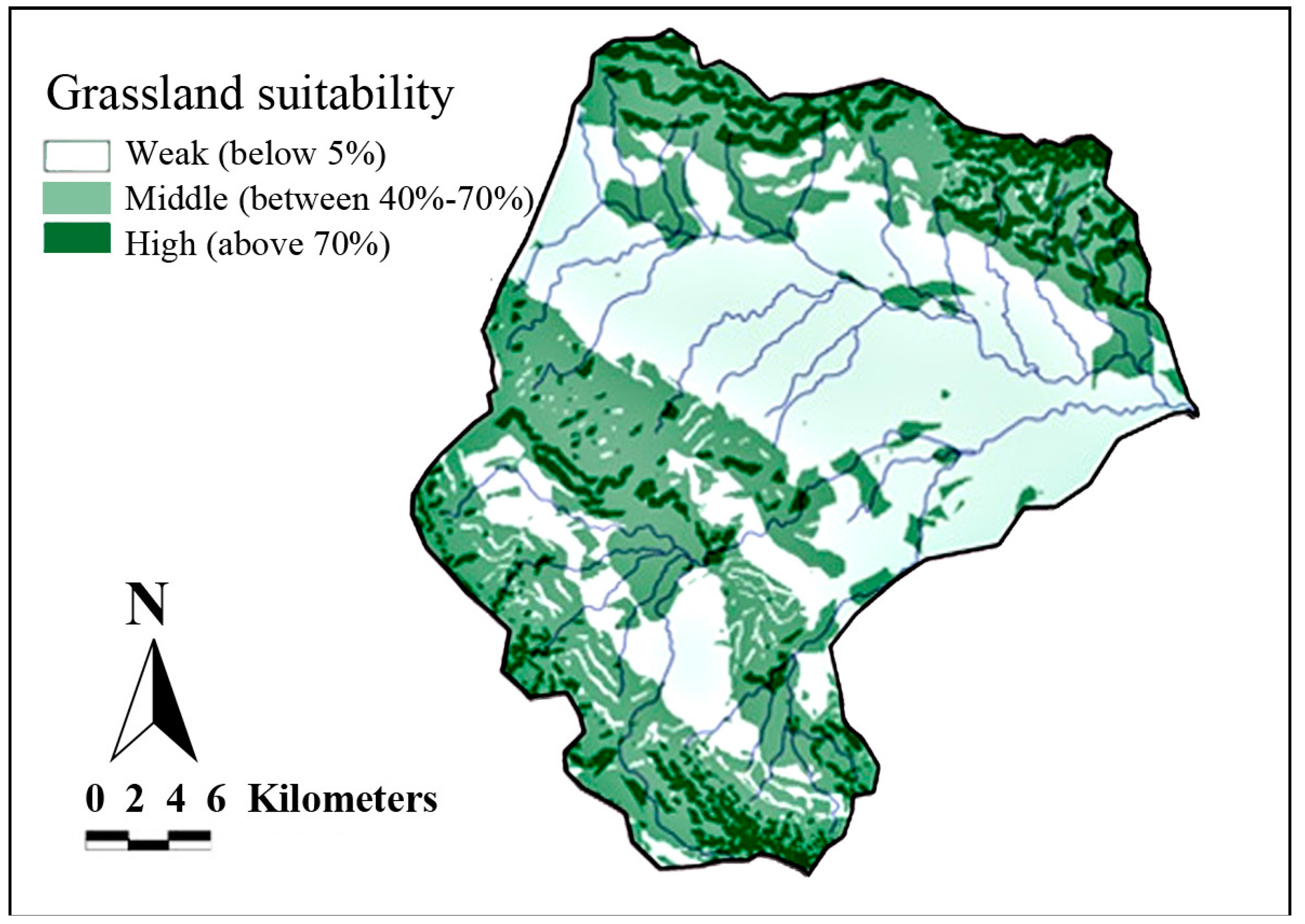
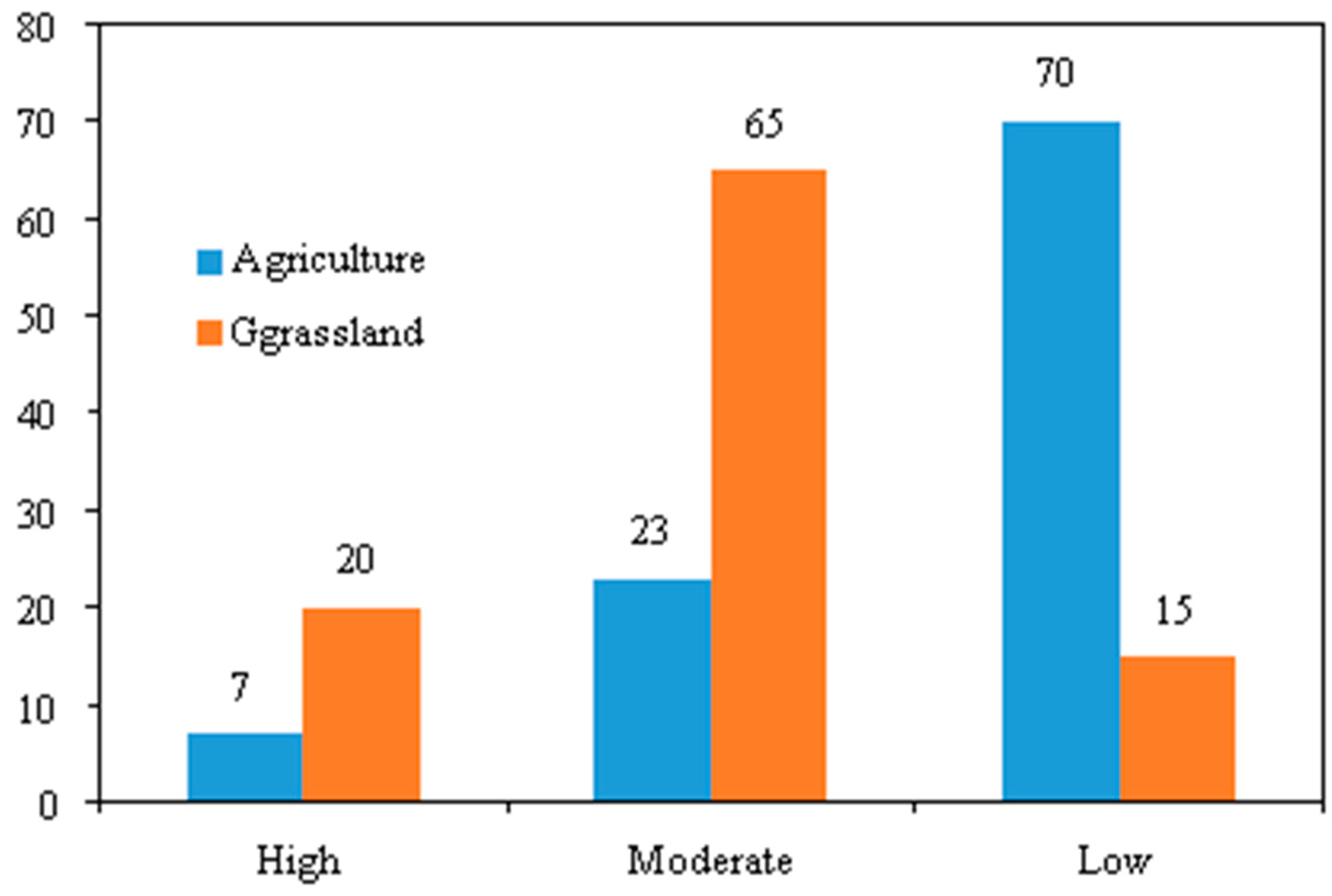
3.3. Ecological Model of Studied Area Potential Determination
4. Conclusions
Author Contributions
Conflicts of Interest
References
- Bhagat, V.S. Use of remote sensing techniques for robust digital change detection of land: A review. Recent Pat. Space Technol. 2012, 2, 123–144. [Google Scholar] [CrossRef]
- Zolekar, R.B.; Bhagat, V. Use of IRS P6 LISS-IV data for land suitability analysis for cashew plantation in hilly zone. Asian J. Geoinform. 2014, 14, 23–35. [Google Scholar]
- Zolekar, R.B.; Bhagat, V.S. Multi-criteria land suitability analysis for agriculture in hilly zone: Remote sensing and GIS approach. Comput. Electron. Agric. 2015, 118, 300–321. [Google Scholar] [CrossRef]
- Sivakumar, M.V.K.; Ndiang’ui, N. Climate and Land Degradation; Springer: Berlin/Heidelberg, Germany, 2007. [Google Scholar]
- Food and Agriculture Organization of the United Nations (FAO); World Food Programme (WFP); International Fund for Agricultural Development (IFAD). The State of Food Insecurity in the World 2012: Economic Growth Is Necessary but Not Sufficient to Accelerate Reduction of Hunger and Malnutrition; FAO: Rome, Italy, 2012; Volume 10. [Google Scholar]
- Nwer, B.A.B. The Application of Land Evaluation Technique in the North-East of Libya. Ph.D. Thesis, University of Tripoli, Tripoli, Libya, January 2006. [Google Scholar]
- Joerin, F.; Thériault, M.; Musy, A. Using GIS and outranking multicriteria analysis for land-use suitability assessment. Int. J. Geogr. Inf. Sci. 2001, 15, 153–174. [Google Scholar] [CrossRef]
- Zhang, J.; Su, Y.; Wu, J.; Liang, H. GIS based land suitability assessment for tobacco production using AHP and fuzzy set in Shandong province of China. Comput. Electron. Agric. 2015, 114, 202–211. [Google Scholar] [CrossRef]
- Elsheikh, R.; Shariff, A.R.B.M.; Amiri, F.; Ahmad, N.B.; Balasundram, S.K.; Soom, M.A.M. Agriculture Land Suitability Evaluator (ALSE): A decision and planning support tool for tropical and subtropical crops. Comput. Electron. Agric. 2013, 93, 98–110. [Google Scholar] [CrossRef] [Green Version]
- Marinoni, O. A discussion on the computational limitations of outranking methods for land-use suitability assessment. Int. J. Geogr. Inf. Sci. 2006, 20, 69–87. [Google Scholar] [CrossRef]
- McHarg, I.L.; Mumford, L. Design with Nature; American Museum of Natural History: New York, NY, USA, 1969. [Google Scholar]
- Bronsveld, K.; Huizing, H.; Omakup, M. Improving land evaluation and land use planning. ITC J. 1994, 4, 359–365. [Google Scholar]
- Rossiter, D.G. A theoretical framework for land evaluation. Geoderma 1996, 72, 165–190. [Google Scholar] [CrossRef]
- Bozdağ, A.; Yavuz, F.; Günay, A.S. AHP and GIS based land suitability analysis for Cihanbeyli (Turkey) County. Environ. Earth Sci. 2016, 75, 1–15. [Google Scholar] [CrossRef]
- Saaty, T.L. The Analytic Hierarchy Process; McGraw-Hill International: New York, NY, USA, 1980. [Google Scholar]
- Aragonés-Beltrán, P.; Chaparro-González, F.; Pastor-Ferrando, J.-P.; Pla-Rubio, A. An AHP (Analytic Hierarchy Process)/ANP (Analytic Network Process)-based multi-criteria decision approach for the selection of solar-thermal power plant investment projects. Energy 2014, 66, 222–238. [Google Scholar] [CrossRef]
- Herrero, M.; Fawcett, R.; Dent, J. Bio-economic evaluation of dairy farm management scenarios using integrated simulation and multiple-criteria models. Agric. Syst. 1999, 62, 169–188. [Google Scholar] [CrossRef]
- Jaafari, A.; Najafi, A.; Melón, M.G. Decision-making for the selection of a best wood extraction method: An analytic network process approach. For. Policy Econ. 2015, 50, 200–209. [Google Scholar] [CrossRef]
- Mazzetto, F.; Bonera, R. MEACROS: A tool for multi-criteria evaluation of alternative cropping systems. Eur. J. Agron. 2003, 18, 379–387. [Google Scholar] [CrossRef]
- Rozman, Č.; Pazek, K.; Bavec, F.; Bavec, M.; Turk, J.; Majkovič, D. A multi-criteria analysis of spelt food processing alternatives on small organic farms. J. Sustain. Agric. 2006, 28, 159–179. [Google Scholar] [CrossRef]
- Tiwari, D.; Loof, R.; Paudyal, G. Environmental-economic decision-making in lowland irrigated agriculture using multi-criteria analysis techniques. Agric. Syst. 1999, 60, 99–112. [Google Scholar] [CrossRef]
- Rossiter, D. Economic land evaluation: Why and how. Soil Use Manag. 1995, 11, 132–140. [Google Scholar] [CrossRef]
- Van de Putte, R. Land evaluation and project planning. ITC J. 1989, 2, 139–143. [Google Scholar]
- Gemitzi, A.; Tsihrintzis, V.A.; Petalas, C. Use of GIS and multi-criteria evaluation techniques in environmental problems. Multimed. Serv. Intell. Environ. 2010, 3, 5–62. [Google Scholar]
- Krois, J.; Schulte, A. GIS-based multi-criteria evaluation to identify potential sites for soil and water conservation techniques in the Ronquillo watershed, northern Peru. Appl. Geogr. 2014, 51, 131–142. [Google Scholar] [CrossRef]
- Al-Adamat, R.; Diabat, A.; Shatnawi, G. Combining GIS with multicriteria decision making for siting water harvesting ponds in Northern Jordan. J. Arid Environ. 2010, 74, 1471–1477. [Google Scholar] [CrossRef]
- Ekmekçioĝlu, M.; Kaya, T.; Kahraman, C. Fuzzy multicriteria disposal method and site selection for municipal solid waste. Waste Manag. 2010, 30, 1729–1736. [Google Scholar] [CrossRef] [PubMed]
- Baiocchi, V.; Lelo, K.; Polettini, A.; Pomi, R. Land suitability for waste disposal in metropolitan areas. Waste Manag. Res. 2014, 32, 707–716. [Google Scholar] [CrossRef] [PubMed]
- Tavares, G.; Zsigraiová, Z.; Semiao, V. Multi-criteria GIS-based siting of an incineration plant for municipal solid waste. Waste Manag. 2011, 31, 1960–1972. [Google Scholar] [CrossRef] [PubMed]
- Moeinaddini, M.; Khorasani, N.; Danehkar, A.; Darvishsefat, A.A. Siting MSW landfill using weighted linear combination and analytical hierarchy process (AHP) methodology in GIS environment (case study: Karaj). Waste Manag. 2010, 30, 912–920. [Google Scholar] [CrossRef] [PubMed]
- Patil, V.; Sankhua, R.; Jain, R. Analytic hierarchy process for evaluation of environmental factors for residential land use suitability. Int. J. Comput. Eng. Res. 2012, 2, 182–189. [Google Scholar]
- Ambarwulan, W.; Setiawan, Y.; Walter, C. Assessing the Suitability and Availability of Land for Agriculture in Tuban Regency, East Java, Indonesia. Appl. Environ. Soil Sci. 2016, 13. [Google Scholar] [CrossRef]
- Kiker, G.A.; Bridges, T.S.; Varghese, A.; Seager, T.P.; Linkov, I. Application of multicriteria decision analysis in environmental decision making. Integr. Environ. Assess. Manag. 2005, 1, 95–108. [Google Scholar] [CrossRef] [PubMed]
- Vlek, P.L.G.; Azadi, H.; Bhaduri, A.; Bharati, L.; Braimoh, A.K.; Martius, C.; Sunderland, T.; Taheri, F. The trade offs in multi-purpose land use. In Land Degradation and the Sustainable Development Goals: Threats and Potential Remedies; Vlek, P., Tamane, L., Eds.; International Centre for Tropical Agriculture (CIAT): Nairobi, Kenya, 2017; pp. 5–17. [Google Scholar]
- Makhdoom, M. Fundamental of Land Use Planning; Tehran University Press: Tehran, Iran, 2001. [Google Scholar]
- Koulouri, M.; Giourga, C. Land abandonment and slope gradient as key factors of soil erosion in Mediterranean terraced lands. Catena 2007, 69, 274–281. [Google Scholar] [CrossRef]
- Bocco, G.; Mendoza, M.; Velázquez, A. Remote sensing and GIS-based regional geomorphological mapping—A tool for land use planning in developing countries. Geomorphology 2001, 39, 211–219. [Google Scholar] [CrossRef]
- Prato, T. Evaluating land use plans under uncertainty. Land Use Policy 2007, 24, 165–174. [Google Scholar] [CrossRef]
- Yalew, S.G.; van Griensven, A.; van der Zaag, P. AgriSuit: A web-based GIS-MCDA framework for agricultural land suitability assessment. Comput. Electron. Agric. 2016, 128, 1–8. [Google Scholar] [CrossRef]
- Romano, G.; Dal Sasso, P.; Trisorio Liuzzi, G.; Gentile, F. Multi-criteria decision analysis for land suitability mapping in a rural area of Southern Italy. Land Use Policy 2015, 48, 131–143. [Google Scholar] [CrossRef]
- Hamzeh, S.; Mokarram, M.; Alavipanah, S.K. Combination of Fuzzy and AHP methods to assess land suitability for barley: Case Study of semi arid lands in the southwest of Iran. Desert 2014, 19, 173–181. [Google Scholar]
- Jankowski, P. Integrating geographical information systems and multiple criteria decision-making methods. Int. J. Geogr. Inf. Syst. 1995, 9, 251–273. [Google Scholar] [CrossRef]
- Mangun, W.R.; Henning, D.H. Managing the Environmental Crisis: Incorporating Competing Values in Natural Resource Administration; Duke University Press: Durham, NC, USA, 1999. [Google Scholar]
- Robinson, R.A. Conservation Security Program: Despite Cost Controls, Improved USA Management Is Needed to Ensure Proper Payments and Reduce Duplication with Other Programs; DIANE Publishing Company: Collingdale, PA, USA, 2006. [Google Scholar]
- Hussein, J.; Yu, B.; Ghadiri, H.; Rose, C. Prediction of surface flow hydrology and sediment retention upslope of a vetiver buffer strip. J. Hydrol. 2007, 338, 261–272. [Google Scholar] [CrossRef]
- Adekalu, K.; Olorunfemi, I.; Osunbitan, J. Grass mulching effect on infiltration, surface runoff and soil loss of three agricultural soils in Nigeria. Bioresour. Technol. 2007, 98, 912–917. [Google Scholar] [CrossRef] [PubMed]
- Novotná, J.; Badalíková, B. The Influence of Grass Species Composition on Fishpond Dikes on Soil Infiltration. Acta Univ. Agric. Silvic. Mendel. Brun. 2016, 64, 1619–1623. [Google Scholar] [CrossRef]
- Natural Resources Conservation Service (NRCS); US Department of Agriculture (USDA). National Handbook of Conservation Practices; US Department of Agriculture/Natural Resources Conservation Service: Washington, DC, USA, 1999.
- Agricultural Bank. The Condition of Agricultural Lands Use Changes; Agricultural Bank: Tehran, Iran, 2011. [Google Scholar]
- Asadi, A.; Barati, A.; Kalantari, K.; Odeh, I. Study of Relationship Between Roads Network Development and Agricultural Land Conversion in Iran NorthWest. Int J. Environ. Res. 2016, 10, 51–58. [Google Scholar]
- Barati, A.A.; Asadi, A.; Kalantari, K.; Azadi, H.; Mamoorian, M. Analyzing the impacts of agricultural land use change according to the experts opinion of agricultural land organization in Iran. Iran. J. Agric. Econ. Dev. Res. 2015, 45, 639–650. [Google Scholar]
- Barati, A.A.; Asadi, A.; Kalantari, K.; Azadi, H.; Witlox, F. Agricultural Land Conversion in Northwest Iran. Int. J. Environ. Res. 2015, 9, 281–290. [Google Scholar]
- Azadi, H.; Barati, A.A.; Rafiaani, P.; Raufirad, V.; Zarafshani, K.; Mamoorian, M.; Lebailly, P. Agricultural Land Conversion Drivers in Northeast Iran: Application of Structural Equation Model. Appl. Spat. Anal. Policy 2016, 9, 591–609. [Google Scholar] [CrossRef]
- Azadi, H.; Barati, A.A.; Rafiaani, P.; Taheri, F.; Gebrehiwot, K.; Witlox, F.; Lebailly, P. Evolution of land use-change modeling: Routes of different schools of knowledge. Landsc. Ecol. Eng. 2016, 13, 1–14. [Google Scholar] [CrossRef]
- Olaniyi, A.O.; Abdullah, A.M.; Ramli, M.F.; Alias, M.S. Assessment of drivers of coastal land use change in Malaysia. Ocean Coast. Manag. 2012, 67, 113–123. [Google Scholar] [CrossRef]
- Rótolo, G.C.; Montico, S.; Francis, C.A.; Ulgiati, S. How land allocation and technology innovation affect the sustainability of agriculture in Argentina Pampas: An expanded life cycle analysis. Agric. Syst. 2015, 141, 79–93. [Google Scholar] [CrossRef]
- Wang, J.; Chen, Y.; Shao, X.; Zhang, Y.; Cao, Y. Land-use changes and policy dimension driving forces in China: Present, trend and future. Land Use Policy 2012, 29, 737–749. [Google Scholar] [CrossRef]
- Zarkesh, M.M.K.; Ghoddusi, J.; Zaredar, N.; Soltani, M.J.; Jafari, S.; Ghadirpour, A. Application of spatial analytical hierarchy process model in land use planning. J. Food Agric. Environ. 2010, 8, 970–975. [Google Scholar]
- Bin, Q.; He-Jian, Z.; Song-Lin, C.; RÖmkens, M.; Bi-Cheng, L. Land Suitability Assessment and Land Use Change in Fujian Province, China** Project supported by the Provincial Natural Science Foundation of Fujian, China (No. D0210010). Pedosphere 2007, 17, 493–504. [Google Scholar]
- Roberts, M.C.; Randolph, J.C.; Chiesa, J.R. A land suitability model for the evaluation of land-use change. Environ. Manag. 1979, 3, 339–352. [Google Scholar] [CrossRef]
- Pierce, S.M.; Cowling, R.M.; Knight, A.T.; Lombard, A.T.; Rouget, M.; Wolf, T. Systematic conservation planning products for land-use planning: Interpretation for implementation. Biol. Conserv. 2005, 125, 441–458. [Google Scholar] [CrossRef]
- Al-Shalabi, M.A.; Mansor, S.B.; Ahmed, N.B.; Shiriff, R. GIS Based Multicriteria Approaches to Housing Site Suitability Assessment. Presented at the XXIII FIG Congress, Shaping the Change, Munich, Germany, 8–13 October 2006. [Google Scholar]
- Chen, Y.; Khan, S.; Padar, Z. Irrigation intensification or extensification assessment: A GIS-based spatial fuzzy multi-criteria evaluation. In Proceedings of the 8th International Symposium on Spatial Accuracy Assessment in Natural Resources and Environmental Sciences, Shanghai, China, 25–27 June 2008. [Google Scholar]
- Duc, T.T. Using GIS and AHP technique for land-use suitability analysis. Presented at the International Symposium on Geoinformatics for Spatial infrastructure Development in Earth and Allied Sciences, Ho Chi Minh City, Vietnam, 9–11 November 2006. [Google Scholar]
- Javaheri, H.; Nasrabadi, T.; Jafarian, M.; Rowshan, G.; Khoshnam, H. Site selection of municipal solid waste landfills using analytical hierarchy process method in a geographical information technology environment in Giroft. J. Environ. Health Sci. Eng. 2006, 3, 177–184. [Google Scholar]
- Thapa, R.B.; Murayama, Y. Land evaluation for peri-urban agriculture using analytical hierarchical process and geographic information system techniques: A case study of Hanoi. Land Use Policy 2008, 25, 225–239. [Google Scholar] [CrossRef] [Green Version]
- Weerakoon, K. Integration of GIS based suitability analysis and multicriteria evaluation for urban land use planning; contribution from the Analytic Hierarchy Process. Presented at the 23rd Asian Conference on Remote Sensing, ACRS Urban Planning, Kathmandu, Nepal, 25–29 November 2002. [Google Scholar]


| Criteria | (P) | (A) | (E) | Weight |
|---|---|---|---|---|
| Physical criteria (P) | 1 | 4 | 5 | 0.674 |
| Agronomic criteria (A) | 0.25 | 1 | 3 | 0.226 |
| Socio-economic criteria (E) | 0.20 | 0.33 | 1 | 0.101 |
| Consistency ratio | 0.076 |
| Sub-Criteria | (P1) | (P2) | (P3) | (P4) | Weight |
|---|---|---|---|---|---|
| Climate (P1) | 1 | 4 | 7 | 8 | 0.611 |
| Topography (P2) | 0.25 | 1 | 5 | 6 | 0.261 |
| Soil (P3) | 0.14 | 0.20 | 1 | 2 | 0.077 |
| Vegetation (P4) | 0.13 | 0.17 | 0.50 | 1 | 0.05 |
| Consistency ratio | 0.068 |
| Sub-Criteria | (A1) | (A2) | (A3) | (A4) | Weight |
|---|---|---|---|---|---|
| Water availability (A1) | 1 | 4 | 7 | 8 | 0.611 |
| Soil fertility (A2) | 0.25 | 1 | 5 | 6 | 0.261 |
| Cultivation ability (A3) | 0.14 | 0.2 | 1 | 2 | 0.077 |
| Use of inputs (A4) | 0.13 | 0.17 | 0.5 | 1 | 0.05 |
| Consistency ratio | 0.068 |
| Sub-Criteria | (E1) | (E2) | (E3) | (E4) | (E5) | Weight |
|---|---|---|---|---|---|---|
| Accessibility area (E1) | 1 | 3 | 5 | 6 | 8 | 0.496 |
| Rangeland grazing capacity (E2) | 0.33 | 1 | 4 | 5 | 7 | 0.287 |
| Cropping pattern (E3) | 0.2 | 0.25 | 1 | 2 | 4 | 0.111 |
| Supply market and revenue increase (E4) | 0.17 | 0.2 | 0.5 | 1 | 2 | 0.067 |
| Investment (E5) | 0.13 | 0.14 | 0.25 | 0.5 | 1 | 0.039 |
| Consistency ratio | 0.044 |
| Criteria | Weight of Criteria | Sub-Criteria | Partial Weight | Overall Weight |
|---|---|---|---|---|
| Physical criteria (P) | 0.674 | Climate (P1) | 0.611 | 0.412 |
| Topography (P2) | 0.261 | 0.176 | ||
| (P3) soil | 0.077 | 0.052 | ||
| Vegetation (P4) | 0.05 | 0.034 | ||
| Agronomic criteria (A) | 0.226 | Water availability (A1) | 0.611 | 0.138 |
| Soil fertility (A2) | 0.261 | 0.059 | ||
| Cultivation ability (A3) | 0.077 | 0.017 | ||
| Use of inputs (A4) | 0.05 | 0.011 | ||
| Socio-Economic criteria (E) | 0.101 | Accessibility area (E1) | 0.496 | 0.050 |
| Rangeland grazing capacity (E2) | 0.287 | 0.029 | ||
| Cropping pattern (E3) | 0.111 | 0.011 | ||
| Supply market and revenue increase (E4) | 0.067 | 0.007 | ||
| Investment (E5) | 0.039 | 0.004 |
| Current Use | Height (m) | Soil | Slope (Degree) | Floor |
|---|---|---|---|---|
| Rain-fed and Irrigated land | 600–950 | Flood plain | 0–2 | Lots |
| Rain-fed | 950–1125 | Mahoori hill and piedmont plain | 2–5 | Medium |
| Grassland | 1125–1825 | Mountain regosols | 5–30 | Inappropriate |
| Current Use | Height (m) | Soil | Slope (Degree) | Floor |
|---|---|---|---|---|
| Grassland | 1475–1825 | Mountain regosols | 15–30 | Lots |
| Grassland | 950–1475 | Mahoori hill and flood plain | 5–15 | Medium |
| Rain-fed and Irrigated land | 600–950 | Piedmont plain and flood plain | 0–5 | Inappropriate |
© 2017 by the authors. Licensee MDPI, Basel, Switzerland. This article is an open access article distributed under the terms and conditions of the Creative Commons Attribution (CC BY) license (http://creativecommons.org/licenses/by/4.0/).
Share and Cite
Memarbashi, E.; Azadi, H.; Barati, A.A.; Mohajeri, F.; Passel, S.V.; Witlox, F. Land-Use Suitability in Northeast Iran: Application of AHP-GIS Hybrid Model. ISPRS Int. J. Geo-Inf. 2017, 6, 396. https://doi.org/10.3390/ijgi6120396
Memarbashi E, Azadi H, Barati AA, Mohajeri F, Passel SV, Witlox F. Land-Use Suitability in Northeast Iran: Application of AHP-GIS Hybrid Model. ISPRS International Journal of Geo-Information. 2017; 6(12):396. https://doi.org/10.3390/ijgi6120396
Chicago/Turabian StyleMemarbashi, Elnaz, Hossein Azadi, Ali Akbar Barati, Fatemeh Mohajeri, Steven Van Passel, and Frank Witlox. 2017. "Land-Use Suitability in Northeast Iran: Application of AHP-GIS Hybrid Model" ISPRS International Journal of Geo-Information 6, no. 12: 396. https://doi.org/10.3390/ijgi6120396