Next Issue
Volume 6, April
Previous Issue
Volume 6, February


ISPRS Int. J. Geo-Inf., Volume 6, Issue 3 (March 2017) – 34 articles

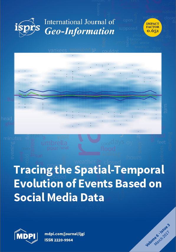
Cover Story (view full-size image): We computed sentiment scores for each rain-related tweet on September 10. The score distribution is represented in a smoothed scatter plot. The purple line represents a completely neutral sentiment while the green curve represents a median sentiment in each hour. Overall, the median sentiment scores were slightly below zero, suggesting a mild negative sentiment.
  • Issues are regarded as officially published after their release is announced to the table of contents alert mailing list.
  • You may sign up for e-mail alerts to receive table of contents of newly released issues.
  • PDF is the official format for papers published in both, html and pdf forms. To view the papers in pdf format, click on the "PDF Full-text" link, and use the free Adobe Reader to open them.
Order results
Result details
Select all
Export citation of selected articles as:
3620 KiB  
Article
Efficient Geometric Pruning Strategies for Continuous Skyline Queries
by Jiping Zheng, Jialiang Chen and Haixiang Wang
ISPRS Int. J. Geo-Inf. 2017, 6(3), 91; https://doi.org/10.3390/ijgi6030091 - 22 Mar 2017
Cited by 7 | Viewed by 3730
Abstract
The skyline query processing problem has been well studied for many years. The literature on skyline algorithms so far mainly considers static query points on static attributes. With the popular usage of mobile devices along with the increasing number of mobile applications and [...] Read more.
The skyline query processing problem has been well studied for many years. The literature on skyline algorithms so far mainly considers static query points on static attributes. With the popular usage of mobile devices along with the increasing number of mobile applications and users, continuous skyline query processing on both static and dynamic attributes has become more pressing. Existing efforts on supporting moving query points assume that the query point moves with only one direction and constant speed. In this paper, we propose continuous skyline computation over an incremental motion model. The query point moves incrementally in discrete time steps with no restrictions and predictability. Geometric properties over incremental motion denoted by a kinetic data structure are utilized to prune the portion of data points not included in final skyline query results. Various geometric strategies are asymptotically proposed to prune the querying dataset, and event-driven mechanisms are adopted to process continuous skyline queries. Extensive experiments under different data sets and parameters demonstrate that the proposed method is robust and more efficient than multiple snapshots of I/O optimal branch-and-bound skyline (BBS) skyline queries. Full article
Show Figures

Figure 1

5066 KiB  
Article
Estimation of 3D Indoor Models with Constraint Propagation and Stochastic Reasoning in the Absence of Indoor Measurements
by Sandra Loch-Dehbi, Youness Dehbi and Lutz Plümer
ISPRS Int. J. Geo-Inf. 2017, 6(3), 90; https://doi.org/10.3390/ijgi6030090 - 21 Mar 2017
Cited by 11 | Viewed by 5406
Abstract
This paper presents a novel method for the prediction of building floor plans based on sparse observations in the absence of measurements. We derive the most likely hypothesis using a maximum a posteriori probability approach. Background knowledge consisting of probability density functions of [...] Read more.
This paper presents a novel method for the prediction of building floor plans based on sparse observations in the absence of measurements. We derive the most likely hypothesis using a maximum a posteriori probability approach. Background knowledge consisting of probability density functions of room shape and location parameters is learned from training data. Relations between rooms and room substructures are represented by linear and bilinear constraints. We perform reasoning on different levels providing a problem solution that is optimal with regard to the given information. In a first step, the problem is modeled as a constraint satisfaction problem. Constraint Logic Programming derives a solution which is topologically correct but suboptimal with regard to the geometric parameters. The search space is reduced using architectural constraints and browsed by intelligent search strategies which use domain knowledge. In a second step, graphical models are used for updating the initial hypothesis and refining its continuous parameters. We make use of Gaussian mixtures for model parameters in order to represent background knowledge and to get access to established methods for efficient and exact stochastic reasoning. We demonstrate our approach on different illustrative examples. Initially, we assume that floor plans are rectangular and that rooms are rectangles and discuss more general shapes afterwards. In a similar spirit, we predict door locations providing further important components of 3D indoor models. Full article
(This article belongs to the Special Issue 3D Indoor Modelling and Navigation)
Show Figures

Figure 1

3447 KiB  
Article
Implementation of Algorithm for Satellite-Derived Bathymetry using Open Source GIS and Evaluation for Tsunami Simulation
by Vinayaraj Poliyapram, Venkatesh Raghavan, Markus Metz, Luca Delucchi and Shinji Masumoto
ISPRS Int. J. Geo-Inf. 2017, 6(3), 89; https://doi.org/10.3390/ijgi6030089 - 18 Mar 2017
Cited by 12 | Viewed by 5775
Abstract
Accurate and high resolution bathymetric data is a necessity for a wide range of coastal oceanographic research topics. Active sensing methods, such as ship-based soundings and Light Detection and Ranging (LiDAR), are expensive and time consuming solutions. Therefore, the significance of Satellite-Derived Bathymetry [...] Read more.
Accurate and high resolution bathymetric data is a necessity for a wide range of coastal oceanographic research topics. Active sensing methods, such as ship-based soundings and Light Detection and Ranging (LiDAR), are expensive and time consuming solutions. Therefore, the significance of Satellite-Derived Bathymetry (SDB) has increased in the last ten years due to the availability of multi-constellation, multi-temporal, and multi-resolution remote sensing data as Open Data. Effective SDB algorithms have been proposed by many authors, but there is no ready-to-use software module available in the Geographical Information System (GIS) environment as yet. Hence, this study implements a Geographically Weighted Regression (GWR) based SDB workflow as a Geographic Resources Analysis Support System (GRASS) GIS module (i.image.bathymetry). Several case studies were carried out to examine the performance of the module in multi-constellation and multi-resolution satellite imageries for different study areas. The results indicate a strong correlation between SDB and reference depth. For instance, case study 1 (Puerto Rico, Northeastern Caribbean Sea) has shown an coefficient of determination (R2) of 0.98 and an Root Mean Square Error (RMSE) of 0.61 m, case study 2 (Iwate, Japan) has shown an R2 of 0.94 and an RMSE of 1.50 m, and case study 3 (Miyagi, Japan) has shown an R2 of 0.93 and an RMSE of 1.65 m. The reference depths were acquired by using LiDAR for case study 1 and an echo-sounder for case studies 2 and 3. Further, the estimated SDB has been used as one of the inputs for the Australian National University and Geoscience Australia (ANUGA) tsunami simulation model. The tsunami simulation results also show close agreement with post-tsunami survey data. The i.mage.bathymetry module developed as a part of this study is made available as an extension for the Open Source GRASS GIS to facilitate wide use and future improvements. Full article
Show Figures

Figure 1

4808 KiB  
Article
Tracing the Spatial-Temporal Evolution of Events Based on Social Media Data
by Xiaolu Zhou and Chen Xu
ISPRS Int. J. Geo-Inf. 2017, 6(3), 88; https://doi.org/10.3390/ijgi6030088 - 18 Mar 2017
Cited by 21 | Viewed by 5470
Abstract
Social media data provide a great opportunity to investigate event flow in cities. Despite the advantages of social media data in these investigations, the data heterogeneity and big data size pose challenges to researchers seeking to identify useful information about events from the [...] Read more.
Social media data provide a great opportunity to investigate event flow in cities. Despite the advantages of social media data in these investigations, the data heterogeneity and big data size pose challenges to researchers seeking to identify useful information about events from the raw data. In addition, few studies have used social media posts to capture how events develop in space and time. This paper demonstrates an efficient approach based on machine learning and geovisualization to identify events and trace the development of these events in real-time. We conducted an empirical study to delineate the temporal and spatial evolution of a natural event (heavy precipitation) and a social event (Pope Francis’ visit to the US) in the New York City—Washington, DC regions. By investigating multiple features of Twitter data (message, author, time, and geographic location information), this paper demonstrates how voluntary local knowledge from tweets can be used to depict city dynamics, discover spatiotemporal characteristics of events, and convey real-time information. Full article
Show Figures

Figure 1

5573 KiB  
Article
Distributed Temperature Measurement in a Self-Burning Coal Waste Pile through a GIS Open Source Desktop Application
by Lia Duarte, Ana Cláudia Teodoro, José Alberto Gonçalves, Joana Ribeiro, Deolinda Flores, Alexia Lopez-Gil, Alejandro Dominguez-Lopez, Xabier Angulo-Vinuesa, Sonia Martin-Lopez and Miguel Gonzalez-Herraez
ISPRS Int. J. Geo-Inf. 2017, 6(3), 87; https://doi.org/10.3390/ijgi6030087 - 17 Mar 2017
Cited by 14 | Viewed by 5533
Abstract
Geographical Information Systems (GIS) are often used to assess and monitor the environmental impacts caused by mining activities. The aim of this work was to develop a new application to produce dynamic maps for monitoring the temperature variations in a self-burning coal waste [...] Read more.
Geographical Information Systems (GIS) are often used to assess and monitor the environmental impacts caused by mining activities. The aim of this work was to develop a new application to produce dynamic maps for monitoring the temperature variations in a self-burning coal waste pile, under a GIS open source environment—GIS-ECOAL (freely available). The performance of the application was evaluated with distributed temperature measurements gathered in the S. Pedro da Cova (Portugal) coal waste pile. In order to obtain the temperature data, an optical fiber cable was disposed over the affected area of the pile, with 42 location stakes acting as precisely-located control points for the temperature measurement. A monthly data set from July (15 min of interval) was fed into the application and a video composed by several layouts with temperature measurements was created allowing for recognizing two main areas with higher temperatures. The field observations also allow the identification of these zones; however, the identification of an area with higher temperatures in the top of the studied area was only possible through the visualization of the images created by this application. The generated videos make possible the dynamic and continuous visualization of the combustion process in the monitored area. Full article
Show Figures

Figure 1

7162 KiB  
Article
Integration of Traffic Information into the Path Planning among Moving Obstacles
by Zhiyong Wang, John Steenbruggen and Sisi Zlatanova
ISPRS Int. J. Geo-Inf. 2017, 6(3), 86; https://doi.org/10.3390/ijgi6030086 - 16 Mar 2017
Cited by 4 | Viewed by 4532
Abstract
This paper investigates the integration of traffic information (TI) into the routing in the presence of moving obstacles. When traffic accidents occur, the incidents could generate different kinds of hazards (e.g., toxic plumes), which make certain parts of the road network inaccessible. On [...] Read more.
This paper investigates the integration of traffic information (TI) into the routing in the presence of moving obstacles. When traffic accidents occur, the incidents could generate different kinds of hazards (e.g., toxic plumes), which make certain parts of the road network inaccessible. On the other hand, the first responders, who are responsible for management of the traffic incidents, need to be fast and safely guided to the incident place. To support navigation in the traffic network affected by moving obstacles, in this paper, we provide a spatio-temporal data model to structure the information of traffic conditions that is essential for the routing, and present an extended path planning algorithm, named MOAAstar–TI (Moving Obstacle Avoiding A* using Traffic Information), to generate routes avoiding the obstacles. A speed adjustment factor is introduced in the developed routing algorithm, allowing integration of both the information of vehicles and traffic situations to generate routes avoiding the moving obstacles caused by the incidents. We applied our system to a set of navigation scenarios. The application results show the potentials of our system in future application in real life. Full article
Show Figures

Figure 1

1808 KiB  
Article
User-Generated Geographic Information for Visitor Monitoring in a National Park: A Comparison of Social Media Data and Visitor Survey
by Vuokko Heikinheimo, Enrico Di Minin, Henrikki Tenkanen, Anna Hausmann, Joel Erkkonen and Tuuli Toivonen
ISPRS Int. J. Geo-Inf. 2017, 6(3), 85; https://doi.org/10.3390/ijgi6030085 - 16 Mar 2017
Cited by 189 | Viewed by 16164
Abstract
Protected area management and marketing require real-time information on visitors’ behavior and preferences. Thus far, visitor information has been collected mostly with repeated visitor surveys. A wealth of content-rich geographic data is produced by users of different social media platforms. These data could [...] Read more.
Protected area management and marketing require real-time information on visitors’ behavior and preferences. Thus far, visitor information has been collected mostly with repeated visitor surveys. A wealth of content-rich geographic data is produced by users of different social media platforms. These data could potentially provide continuous information about people’s activities and interactions with the environment at different spatial and temporal scales. In this paper, we compare social media data with traditional survey data in order to map people’s activities and preferences using the most popular national park in Finland, Pallas-Yllästunturi National Park, as a case study. We compare systematically collected survey data and the content of geotagged social media data and analyze: (i) where do people go within the park; (ii) what are their activities; (iii) when do people visit the park and if there are temporal patterns in their activities; (iv) who the visitors are; (v) why people visit the national park; and (vi) what complementary information from social media can provide in addition to the results from traditional surveys. The comparison of survey and social media data demonstrated that geotagged social media content provides relevant information about visitors’ use of the national park. As social media platforms are a dynamic source of data, they could complement and enrich traditional forms of visitor monitoring by providing more insight on emerging activities, temporal patterns of shared content, and mobility patterns of visitors. Potentially, geotagged social media data could also provide an overview of the spatio-temporal activity patterns in other areas where systematic visitor monitoring is not taking place. Full article
(This article belongs to the Special Issue Volunteered Geographic Information)
Show Figures

Figure 1

3283 KiB  
Article
Elastic Spatial Query Processing in OpenStack Cloud Computing Environment for Time-Constraint Data Analysis
by Wei Huang, Wen Zhang, Dongying Zhang and Lingkui Meng
ISPRS Int. J. Geo-Inf. 2017, 6(3), 84; https://doi.org/10.3390/ijgi6030084 - 15 Mar 2017
Cited by 12 | Viewed by 6583
Abstract
Geospatial big data analysis (GBDA) is extremely significant for time-constraint applications such as disaster response. However, the time-constraint analysis is not yet a trivial task in the cloud computing environment. Spatial query processing (SQP) is typical computation-intensive and indispensable for GBDA, and the [...] Read more.
Geospatial big data analysis (GBDA) is extremely significant for time-constraint applications such as disaster response. However, the time-constraint analysis is not yet a trivial task in the cloud computing environment. Spatial query processing (SQP) is typical computation-intensive and indispensable for GBDA, and the spatial range query, join query, and the nearest neighbor query algorithms are not scalable without using MapReduce-liked frameworks. Parallel SQP algorithms (PSQPAs) are trapped in screw-processing, which is a known issue in Geoscience. To satisfy time-constrained GBDA, we propose an elastic SQP approach in this paper. First, Spark is used to implement PSQPAs. Second, Kubernetes-managed Core Operation System (CoreOS) clusters provide self-healing Docker containers for running Spark clusters in the cloud. Spark-based PSQPAs are submitted to Docker containers, where Spark master instances reside. Finally, the horizontal pod auto-scaler (HPA) would scale-out and scale-in Docker containers for supporting on-demand computing resources. Combined with an auto-scaling group of virtual instances, HPA helps to find each of the five nearest neighbors for 46,139,532 query objects from 834,158 spatial data objects in less than 300 s. The experiments conducted on an OpenStack cloud demonstrate that auto-scaling containers can satisfy time-constraint GBDA in clouds. Full article
Show Figures

Figure 1

6189 KiB  
Article
A GIS-Based Evaluation of the Effectiveness and Spatial Coverage of Public Transport Networks in Tourist Destinations
by Antoni Domènech and Aaron Gutiérrez
ISPRS Int. J. Geo-Inf. 2017, 6(3), 83; https://doi.org/10.3390/ijgi6030083 - 15 Mar 2017
Cited by 26 | Viewed by 8458
Abstract
This article develops a methodology for evaluating the effectiveness and spatial coverage of public transport in tourist cities. The proposed methodology is applied and validated in Cambrils municipality, in the central part of the Costa Daurada in Catalonia, a coastal destination characterised by [...] Read more.
This article develops a methodology for evaluating the effectiveness and spatial coverage of public transport in tourist cities. The proposed methodology is applied and validated in Cambrils municipality, in the central part of the Costa Daurada in Catalonia, a coastal destination characterised by the concentration of tourism flows during summer. The application of GIS spatial analysis tools allows for the development of a system of territorial indicators that spatially correlate the public transport network and the distribution of the population. The main novelty of our work is that this analysis not only includes the registered resident population, but also incorporates the population that temporarily inhabits the municipality (tourists). The results of the study firstly permit the detection of unequal spatial accessibility and coverage in terms of public transport in the municipality, with significant differences between central neighbourhoods and peripheral urban areas of lower population density. Secondly, they allow observation of how the degree of public transport coverage differs significantly in areas with a higher concentration of tourist accommodation establishments. Full article
Show Figures

Figure 1

525 KiB  
Article
A Dynamic Data Structure to Efficiently Find the Points below a Line and Estimate Their Number
by Bart Kuijpers and Peter Z. Revesz
ISPRS Int. J. Geo-Inf. 2017, 6(3), 82; https://doi.org/10.3390/ijgi6030082 - 15 Mar 2017
Cited by 1 | Viewed by 3720
Abstract
A basic question in computational geometry is how to find the relationship between a set of points and a line in a real plane. In this paper, we present multidimensional data structures for N points that allow answering the following queries for any [...] Read more.
A basic question in computational geometry is how to find the relationship between a set of points and a line in a real plane. In this paper, we present multidimensional data structures for N points that allow answering the following queries for any given input line: (1) estimate in O ( log N ) time the number of points below the line; (2) return in O ( log N + k ) time the k N points that are below the line; and (3) return in O ( log N ) time the point that is closest to the line. We illustrate the utility of this computational question with GIS applications in air defense and traffic control. Full article
Show Figures

Figure 1

8927 KiB  
Article
Assessment of Wetland Ecosystem Health in the Yangtze and Amazon River Basins
by Rui Sun, Pingping Yao, Wen Wang, Bing Yue and Gang Liu
ISPRS Int. J. Geo-Inf. 2017, 6(3), 81; https://doi.org/10.3390/ijgi6030081 - 14 Mar 2017
Cited by 49 | Viewed by 8747
Abstract
As “kidneys of the earth”, wetlands play an important role in ameliorating weather conditions, flood storage, and the control and reduction of environmental pollution. With the development of local economies, the wetlands in both the Amazon and Yangtze River Basins have been affected [...] Read more.
As “kidneys of the earth”, wetlands play an important role in ameliorating weather conditions, flood storage, and the control and reduction of environmental pollution. With the development of local economies, the wetlands in both the Amazon and Yangtze River Basins have been affected and threatened by human activities, such as urban expansion, reclamation of land from lakes, land degradation, and large-scale agricultural development. It is necessary and important to develop a wetland ecosystem health evaluation model and to quantitatively evaluate the wetland ecosystem health in these two basins. In this paper, GlobeLand30 land cover maps and socio-economic and climate data from 2000 and 2010 were adopted to assess the wetland ecosystem health of the Yangtze and Amazon River Basins on the basis of a pressure-state-response (PSR) model. A total of 13 indicators were selected to build the wetland health assessment system. Weights of these indicators and PSR model components, as well as normalized wetland health scores, were assigned and calculated based on the analytic hierarchy process method. The results showed that from 2000 to 2010, the value of the mean wetland ecosystem health index in the Yangtze River Basin decreased from 0.482 to 0.481, while it increased from 0.582 to 0.593 in the Amazon River Basin. This indicated that the average status of wetland ecosystem health in the Amazon River Basin is better than that in the Yangtze River Basin, and that wetland health improved over time in the Amazon River Basin but worsened in the Yangtze River Basin. Full article
(This article belongs to the Special Issue Analysis and Applications of Global Land Cover Data)
Show Figures

Figure 1

7829 KiB  
Article
Assessing Crowdsourced POI Quality: Combining Methods Based on Reference Data, History, and Spatial Relations
by Guillaume Touya, Vyron Antoniou, Ana-Maria Olteanu-Raimond and Marie-Dominique Van Damme
ISPRS Int. J. Geo-Inf. 2017, 6(3), 80; https://doi.org/10.3390/ijgi6030080 - 14 Mar 2017
Cited by 41 | Viewed by 7267
Abstract
With the development of location-aware devices and the success and high use of Web 2.0 techniques, citizens are able to act as sensors by contributing geographic information. In this context, data quality is an important aspect that should be taken into account when [...] Read more.
With the development of location-aware devices and the success and high use of Web 2.0 techniques, citizens are able to act as sensors by contributing geographic information. In this context, data quality is an important aspect that should be taken into account when using this source of data for different purposes. The goal of the paper is to analyze the quality of crowdsourced data and to study its evolution over time. We propose two types of approaches: (1) use the intrinsic characteristics of the crowdsourced datasets; or (2) evaluate crowdsourced Points of Interest (POIs) using external datasets (i.e., authoritative reference or other crowdsourced datasets), and two different methods for each approach. The potential of the combination of these approaches is then demonstrated, to overcome the limitations associated with each individual method. In this paper, we focus on POIs and places coming from the very successful crowdsourcing project: OpenStreetMap. The results show that the proposed approaches are complementary in assessing data quality. The positive results obtained for data matching show that the analysis of data quality through automatic data matching is possible but considerable effort and attention are needed for schema matching given the heterogeneity of OSM and the representation of authoritative datasets. For the features studied, it can be noted that change over time is sometimes due to disagreements between contributors, but in most cases the change improves the quality of the data. Full article
(This article belongs to the Special Issue Volunteered Geographic Information)
Show Figures

Figure 1

4997 KiB  
Article
An Integrated Approach for Monitoring and Information Management of the Guanling Landslide (China)
by Wei Hou, Xuejun Lu, Pengda Wu, An Xue and Liuke Li
ISPRS Int. J. Geo-Inf. 2017, 6(3), 79; https://doi.org/10.3390/ijgi6030079 - 12 Mar 2017
Cited by 12 | Viewed by 4796
Abstract
Landslide triggered by earthquake or rainstorm often results in serious property damage and human casualties. It is, therefore, necessary to establish an emergency management system to facilitate the processes of damage assessment and decision-making. This paper has presented an integrated approach for mapping [...] Read more.
Landslide triggered by earthquake or rainstorm often results in serious property damage and human casualties. It is, therefore, necessary to establish an emergency management system to facilitate the processes of damage assessment and decision-making. This paper has presented an integrated approach for mapping and analyzing spatial features of a landslide from remote sensing images and Digital Elevation Models (DEMs). Several image interpretation tools have been provided for analyzing the spatial distribution and characteristics of the landslide on different dimensions: (1D) terrain variation analysis along the mass movement direction and (3D) morphological analysis. In addition, the results of image interpretation can be further discussed and adjusted on an online cooperating platform, which was built to improve the coordination of all players involved in different phases of emergency management, e.g., hazard experts, emergency managers, and first response organizations. A mobile-based application has also been developed to enhance the data exchange and on-site investigation. Our pilot study of Guanling landslide shows that the presented approach has the potential to facilitate the phases of landslide monitoring and information management, e.g., hazard assessment, emergency preparedness, planning mitigation, and response. Full article
Show Figures

Figure 1

1397 KiB  
Article
On Data Quality Assurance and Conflation Entanglement in Crowdsourcing for Environmental Studies
by Didier G. Leibovici, Julian F. Rosser, Crona Hodges, Barry Evans, Michael J. Jackson and Chris I. Higgins
ISPRS Int. J. Geo-Inf. 2017, 6(3), 78; https://doi.org/10.3390/ijgi6030078 - 11 Mar 2017
Cited by 22 | Viewed by 6024
Abstract
Volunteer geographical information (VGI), either in the context of citizen science or the mining of social media, has proven to be useful in various domains including natural hazards, health status, disease epidemics, and biological monitoring. Nonetheless, the variable or unknown data quality due [...] Read more.
Volunteer geographical information (VGI), either in the context of citizen science or the mining of social media, has proven to be useful in various domains including natural hazards, health status, disease epidemics, and biological monitoring. Nonetheless, the variable or unknown data quality due to crowdsourcing settings are still an obstacle for fully integrating these data sources in environmental studies and potentially in policy making. The data curation process, in which a quality assurance (QA) is needed, is often driven by the direct usability of the data collected within a data conflation process or data fusion (DCDF), combining the crowdsourced data into one view, using potentially other data sources as well. Looking at current practices in VGI data quality and using two examples, namely land cover validation and inundation extent estimation, this paper discusses the close links between QA and DCDF. It aims to help in deciding whether a disentanglement can be possible, whether beneficial or not, in understanding the data curation process with respect to its methodology for future usage of crowdsourced data. Analysing situations throughout the data curation process where and when entanglement between QA and DCDF occur, the paper explores the various facets of VGI data capture, as well as data quality assessment and purposes. Far from rejecting the usability ISO quality criterion, the paper advocates for a decoupling of the QA process and the DCDF step as much as possible while still integrating them within an approach analogous to a Bayesian paradigm. Full article
(This article belongs to the Special Issue Volunteered Geographic Information)
Show Figures

Figure 1

9417 KiB  
Article
A Spatial Lattice Model Applied for Meteorological Visualization and Analysis
by Mingyue Lu, Min Chen, Xuan Wang, Jinzhong Min and Aili Liu
ISPRS Int. J. Geo-Inf. 2017, 6(3), 77; https://doi.org/10.3390/ijgi6030077 - 09 Mar 2017
Cited by 6 | Viewed by 5973
Abstract
Meteorological information has obvious spatial-temporal characteristics. Although it is meaningful to employ a geographic information system (GIS) to visualize and analyze the meteorological information for better identification and forecasting of meteorological weather so as to reduce the meteorological disaster loss, modeling meteorological information [...] Read more.
Meteorological information has obvious spatial-temporal characteristics. Although it is meaningful to employ a geographic information system (GIS) to visualize and analyze the meteorological information for better identification and forecasting of meteorological weather so as to reduce the meteorological disaster loss, modeling meteorological information based on a GIS is still difficult because meteorological elements generally have no stable shape or clear boundary. To date, there are still few GIS models that can satisfy the requirements of both meteorological visualization and analysis. In this article, a spatial lattice model based on sampling particles is proposed to support both the representation and analysis of meteorological information. In this model, a spatial sampling particle is regarded as the basic element that contains the meteorological information, and the location where the particle is placed with the time mark. The location information is generally represented using a point. As these points can be extended to a surface in two dimensions and a voxel in three dimensions, if these surfaces and voxels can occupy a certain space, then this space can be represented using these spatial sampling particles with their point locations and meteorological information. In this case, the full meteorological space can then be represented by arranging numerous particles with their point locations in a certain structure and resolution, i.e., the spatial lattice model, and extended at a higher resolution when necessary. For practical use, the meteorological space is logically classified into three types of spaces, namely the projection surface space, curved surface space, and stereoscopic space, and application-oriented spatial lattice models with different organization forms of spatial sampling particles are designed to support the representation, inquiry, and analysis of meteorological information within the three types of surfaces. Cases studies are conducted by (1) performing a visualization of radar data that is used to describe the reflectivity factor of a raindrop and the pressure field information acquired from the National Centers for Environmental Prediction (NCEP), and (2) taking cutting analysis as another example where advanced meteorological analysis is performed. The results show that the proposed spatial lattice model can contribute to the feasible and effective analysis of meteorological information. Full article
Show Figures

Figure 1

6045 KiB  
Article
A Web-Based Visual and Analytical Geographical Information System for Oil and Gas Data
by Yuanchen Li, Bingjie Wei and Xin Wang
ISPRS Int. J. Geo-Inf. 2017, 6(3), 76; https://doi.org/10.3390/ijgi6030076 - 09 Mar 2017
Cited by 6 | Viewed by 6575
Abstract
With the development of strategic oil and gas assets, massive spatiotemporal oil and gas data have been accumulated. Application systems that assist in the storage and management of the voluminous and complex oil and gas datasets are in high demand. The voluminous and [...] Read more.
With the development of strategic oil and gas assets, massive spatiotemporal oil and gas data have been accumulated. Application systems that assist in the storage and management of the voluminous and complex oil and gas datasets are in high demand. The voluminous and various data should be leveraged and turned into information for business decision-making and operation assistance. In this paper, we propose a set of visual analytic methods that specialize in oil and gas data; and, we develop a web-based oil and gas data management, visualization and analytical system, called Oil and Gas Visual Exploration System (OGVES). With OGVES, complex and multi-sourced oil and gas data can be stored, searched, filtered, and represented. As a web-based system, the OGVES provides more accessibility, convenience and efficiency than traditional desktop systems. Spatial scales and temporal primitives contained in oil and gas data are discussed. Different visualization methods are then presented to explore and represent spatiotemporal features of the oil and gas data. Various case studies demonstrate the usability of the system. Full article
(This article belongs to the Special Issue Web/Cloud Based Mapping and Geoinformation)
Show Figures

Figure 1

2893 KiB  
Article
Applicability Analysis of VTEC Derived from the Sophisticated Klobuchar Model in China
by Jun Chen, Liangke Huang, Lilong Liu, Pituan Wu and Xuyuan Qin
ISPRS Int. J. Geo-Inf. 2017, 6(3), 75; https://doi.org/10.3390/ijgi6030075 - 09 Mar 2017
Cited by 13 | Viewed by 5271
Abstract
Although the Klobuchar model is widely used in single-frequency GPS receivers, it cannot effectively correct the ionospheric delay. The Klobuchar model sets the night ionospheric delay as a constant, i.e., it cannot reflect temporal changes at night. The observation data of seventeen International [...] Read more.
Although the Klobuchar model is widely used in single-frequency GPS receivers, it cannot effectively correct the ionospheric delay. The Klobuchar model sets the night ionospheric delay as a constant, i.e., it cannot reflect temporal changes at night. The observation data of seventeen International Global Navigation Satellite System Service (IGS) stations within and around China from 2011 provided by the IGS center are used in this study to calculate the Total Electron Content (TEC) values using the Klobuchar model and the dual-frequency model. The Holt–Winters exponential smoothing model is used to forecast the error of the 7th day between the Klobuchar model and the dual-frequency model by using the error of the former six days. The forecast results are used to develop the sophisticated Klobuchar model when no epochs are missing, considering that certain reasons may result in some of the observation data being missing and weaken the relationship between each epoch in practical applications. We study the applicability of the sophisticated Klobuchar model when observation data are missing. This study deletes observation data of some epochs randomly and then calculates TEC values using the Klobuchar model. A cubic spline curve is used to restore the missing TEC values calculated in the Klobuchar mode. Finally, we develop the sophisticated Klobuchar model when N epochs are missing in China. The sophisticated Klobuchar model is compared with the dual-frequency model. The experimental results reveal the following: (1) the sophisticated Klobuchar model can correct the ionospheric delay more significantly than the Klobuchar model; (2) the sophisticated Klobuchar model can reflect the ionosphere temporal evolution, particularly at night, with the correct results increasing with increasing latitude; and (3) the sophisticated Klobuchar model can achieve remarkable correction results when N epochs are missing, with the correct results being nearly as good as that of the dual-frequency model when no epochs are missing. Full article
(This article belongs to the Special Issue Recent Advances in Geodesy & Its Applications)
Show Figures

Figure 1

2511 KiB  
Article
Land Use Influencing the Spatial Distribution of Urban Crime: A Case Study of Szczecin, Poland
by Natalia Sypion-Dutkowska and Michael Leitner
ISPRS Int. J. Geo-Inf. 2017, 6(3), 74; https://doi.org/10.3390/ijgi6030074 - 08 Mar 2017
Cited by 57 | Viewed by 15501
Abstract
This paper falls into a common field of scientific research and its practical applications at the interface of urban geography, environmental criminology, and Geographic Information Systems (GIS). The purpose of this study is to identify types of different land use which influence the [...] Read more.
This paper falls into a common field of scientific research and its practical applications at the interface of urban geography, environmental criminology, and Geographic Information Systems (GIS). The purpose of this study is to identify types of different land use which influence the spatial distribution of a set of crime types at the intra-urban scale. The originality of the adopted approach lies in its consideration of a large number of different land use types considered as hypothetically influencing the spatial distribution of nine types of common crimes, geocoded at the address-level: car crimes, theft of property—other, residential crimes, property damage, commercial crimes, drug crimes, burglary in other commercial buildings, robbery, and fights and battery. The empirical study covers 31,319 crime events registered by the Police in the years 2006–2010 in the Polish city of Szczecin with a population ca. 405,000. Main research methods used are the GIS tool “multiple ring buffer” and the “crime location quotient (LQC)”. The main conclusion from this research is that a strong influence of land use types analyzed is limited to their immediate surroundings (i.e., within a distance of 50 m), with the highest concentration shown by commercial crimes and by the theft of property—other crime type. Land use types strongly attracting crime in this zone are alcohol outlets, clubs and discos, cultural facilities, municipal housing, and commercial buildings. In contrast, grandstands, cemeteries, green areas, allotment gardens, and depots and transport base are land use types strongly detracting crime in this zone. Full article
(This article belongs to the Special Issue Frontiers in Spatial and Spatiotemporal Crime Analytics)
Show Figures

Figure 1

182 KiB  
Editorial
Frontiers in Spatial and Spatiotemporal Crime Analytics—An Editorial
by Marco Helbich and Michael Leitner
ISPRS Int. J. Geo-Inf. 2017, 6(3), 73; https://doi.org/10.3390/ijgi6030073 - 06 Mar 2017
Cited by 5 | Viewed by 4368
Abstract
Environmental criminological theory is well-developed [1,2] but analytical techniques to explore and model crime incidents are lagging behind. Due to the emergence and accumulation of a wide range of environmental data [...] Full article
(This article belongs to the Special Issue Frontiers in Spatial and Spatiotemporal Crime Analytics)
2496 KiB  
Article
Salience Indicators for Landmark Extraction at Large Spatial Scales Based on Spatial Analysis Methods
by Min Weng, Qin Xiong and Mengjun Kang
ISPRS Int. J. Geo-Inf. 2017, 6(3), 72; https://doi.org/10.3390/ijgi6030072 - 04 Mar 2017
Cited by 9 | Viewed by 5519
Abstract
Urban landmarks are frequently used in way-finding and representations of spatial knowledge. However, assessing the salience of urban landmarks is difficult. Moreover, no method exists to rapidly extract urban landmarks from basic geographic information databases. The goal of this paper is to solve [...] Read more.
Urban landmarks are frequently used in way-finding and representations of spatial knowledge. However, assessing the salience of urban landmarks is difficult. Moreover, no method exists to rapidly extract urban landmarks from basic geographic information databases. The goal of this paper is to solve these problems from the dual aspects of spatial knowledge representation and public spatial cognition rules. A clear and systematic definition for multiple-scale urban landmarks is proposed, together with a category reference for extracting small- and medium-scale urban landmarks and a model for the large-scale automatic extraction of urban landmarks. In this large-scale automatic urban landmark extraction model, the salience is expressed by two weighted parameters: the check-in totals and local accessibility. The extraction threshold is set according to a predefined number of landmarks to be extracted. Experiments show that the extraction results match the reference data well. Full article
(This article belongs to the Special Issue Location-Based Services)
Show Figures

Figure 1

596 KiB  
Article
GSMNet: A Hierarchical Graph Model for Moving Objects in Networks
by Hengcai Zhang and Feng Lu
ISPRS Int. J. Geo-Inf. 2017, 6(3), 71; https://doi.org/10.3390/ijgi6030071 - 03 Mar 2017
Cited by 4 | Viewed by 4402
Abstract
Existing data models for moving objects in networks are often limited by flexibly controlling the granularity of representing networks and the cost of location updates and do not encompass semantic information, such as traffic states, traffic restrictions and social relationships. In this paper, [...] Read more.
Existing data models for moving objects in networks are often limited by flexibly controlling the granularity of representing networks and the cost of location updates and do not encompass semantic information, such as traffic states, traffic restrictions and social relationships. In this paper, we aim to fill the gap of traditional network-constrained models and propose a hierarchical graph model called the Geo-Social-Moving model for moving objects in Networks (GSMNet) that adopts four graph structures, RouteGraph, SegmentGraph, ObjectGraph and MoveGraph, to represent the underlying networks, trajectories and semantic information in an integrated manner. The bulk of user-defined data types and corresponding operators is proposed to handle moving objects and answer a new class of queries supporting three kinds of conditions: spatial, temporal and semantic information. Then, we develop a prototype system with the native graph database system Neo4Jto implement the proposed GSMNet model. In the experiment, we conduct the performance evaluation using simulated trajectories generated from the BerlinMOD (Berlin Moving Objects Database) benchmark and compare with the mature MOD system Secondo. The results of 17 benchmark queries demonstrate that our proposed GSMNet model has strong potential to reduce time-consuming table join operations an d shows remarkable advantages with regard to representing semantic information and controlling the cost of location updates. Full article
Show Figures

Figure 1

10438 KiB  
Article
A Multi-Scale Residential Areas Matching Method Using Relevance Vector Machine and Active Learning
by Xinchang Zhang, Guowei Luo, Guangjing He and Liyan Chen
ISPRS Int. J. Geo-Inf. 2017, 6(3), 70; https://doi.org/10.3390/ijgi6030070 - 03 Mar 2017
Cited by 9 | Viewed by 3930
Abstract
Multi-scale object matching is the key technology for upgrading feature cascade and integrating multi-source spatial data. Considering the distinctiveness of data at different scales, the present study selects residential areas in a multi-scale database as research objects and focuses on characteristic similarities. This [...] Read more.
Multi-scale object matching is the key technology for upgrading feature cascade and integrating multi-source spatial data. Considering the distinctiveness of data at different scales, the present study selects residential areas in a multi-scale database as research objects and focuses on characteristic similarities. This study adopts the method of merging with no simplification, clarifies all the matching pairs that lack one-to-one relationships and places them into one-to-one matching pairs, and conducts similarity measurements on five characteristics (i.e., position, area, shape, orientation, and surroundings). The relevance vector machine (RVM) algorithm is introduced, and the method of RVM-based spatial entity matching is designed, thus avoiding the needs of weighing feature similarity and selecting matching thresholds. Moreover, the study utilizes the active learning approach to select the most effective sample for classification, which reduces the manual work of labeling samples. By means of 1:5000 and 1:25,000 residential areas matching experiments, it is shown that the RVM method could achieve high matching precision, which can be used to accurately recognize 1:1, 1:m, and m:n matching relations, thus improving automation and the intelligence level of geographical spatial data management. Full article
Show Figures

Figure 1

1789 KiB  
Article
The Analysis of Task and Data Characteristic and the Collaborative Processing Method in Real-Time Visualization Pipeline of Urban 3DGIS
by Dongbo Zhou, Gang Jiang, Jie Yu, Leyuan Liu and Wenbo Li
ISPRS Int. J. Geo-Inf. 2017, 6(3), 69; https://doi.org/10.3390/ijgi6030069 - 02 Mar 2017
Cited by 2 | Viewed by 4843
Abstract
Parallel processing in the real-time visualization of three-dimensional Geographic Information Systems (3DGIS) has tended to concentrate on algorithm levels in recent years, and most of the existing methods employ multiple threads in a Central Processing Unit (CPU) or kernel in a Graphics Processing [...] Read more.
Parallel processing in the real-time visualization of three-dimensional Geographic Information Systems (3DGIS) has tended to concentrate on algorithm levels in recent years, and most of the existing methods employ multiple threads in a Central Processing Unit (CPU) or kernel in a Graphics Processing Unit (GPU) to improve efficiency in the computation of the Level of Details (LODs) for three-dimensional (3D) Models and in the display of Digital Elevation Models (DEMs) and Digital Orthphoto Maps (DOMs). The systematic analysis of the task and data characteristics of parallelism in the real-time visualization of 3DGIS continues to fall behind the development of hardware. In this paper, the basic procedures of real-time visualization of urban 3DGIS are first reviewed, and then the real-time visualization pipeline is analyzed. Further, the pipeline is decomposed into different task stages based on the task order and the input-output dependency. Based on the analysis of task parallelism in different pipeline stages, the data parallelism characteristics in each task are summarized by studying the involved algorithms. Finally, this paper proposes a parallel co-processing mode and a collaborative strategy for real-time visualization of urban 3DGIS. It also provides a fundamental basis for developing parallel algorithms and strategies in 3DGIS. Full article
(This article belongs to the Special Issue Recent Advances in Geodesy & Its Applications)
Show Figures

Figure 1

11552 KiB  
Article
Spatio-Temporal Change Detection of Ningbo Coastline Using Landsat Time-Series Images during 1976–2015
by Xia Wang, Yaolin Liu, Feng Ling, Yanfang Liu and Feiguo Fang
ISPRS Int. J. Geo-Inf. 2017, 6(3), 68; https://doi.org/10.3390/ijgi6030068 - 02 Mar 2017
Cited by 64 | Viewed by 7803
Abstract
Ningbo City in Zhejiang Province is one of the largest port cities in China and has achieved high economic development during the past decades. The port construction, land reclamation, urban development and silt deposition in the Ningbo coastal zone have resulted in extensive [...] Read more.
Ningbo City in Zhejiang Province is one of the largest port cities in China and has achieved high economic development during the past decades. The port construction, land reclamation, urban development and silt deposition in the Ningbo coastal zone have resulted in extensive coastline change. In this study, the spatio-temporal change of the Ningbo coastlines during 1976–2015 was detected and analysed using Landsat time-series images from different sensors, including Multispectral Scanner (MSS), Thematic Mapper (TM), Enhanced Thematic Mapper Plus (ETM+) and Operational Land Imager (OLI). Fourteen individual scenes (covering seven phases) of cloud-free Landsat images within the required tidal range of ±63 cm were collected. The ZiYuan-3 (ZY-3) image of 2015 was used to extract the reference coastline for the accuracy assessment. The normalised difference water index (NDWI) and the modified normalized difference water index (MNDWI) were applied to discriminate surface water and land features, respectively. The on-screen digitising approach was then used to further refine the extracted time-series coastlines in the period from 1976 to 2015. Six relevant indices, length, length change, annual length change, fractal dimension (FD), average net shoreline movement (NSM) and average annual NSM, were calculated to analyse and explore the spatio-temporal change features of Ningbo coastlines. Results show that the length of the Ningbo coastlines increased from 910 km to 986 km, and the value of FD increased from 1.09 to 1.12, and the coastline morphology changed from sinuous to straight. The average NSM increased from 187 m to 298 m and the average annual NSM reached 85 m/year, indicating the advance of coastlines towards the sea at a high level. The spatio-temporal change patterns also varied in different areas. In Hangzhou Bay, significant advancement along the coastlines was experienced since 2001 mainly because of urban construction and land reclamation. In Xiangshan Bay, the forces of nature played a major role in coastline dynamics before 2008, whilst port construction, urban construction and island link projections moved the coastlines towards the sea. The coastline changes of Sanmen Bay were affected by the interaction of nature and human activities. All these observations indicate that forces of nature and human activities were the two important influential factors for the observed coastline change. In this case, the coastline complexity variation was considered responsible for various coastline patterns change of the Ningbo coast. In addition, erosion and accretion occurred in turn because of forces of nature and human activities, such as urban development and agricultural exploitation. Full article
(This article belongs to the Special Issue Earth/Community Observations for Climate Change Research)
Show Figures

Figure 1

10350 KiB  
Article
Applying OGC Standards to Develop a Land Surveying Measurement Model
by Ioannis Sofos, Vassilios Vescoukis, Athanasios Gkegkas and Elisavet Tsilimantou
ISPRS Int. J. Geo-Inf. 2017, 6(3), 67; https://doi.org/10.3390/ijgi6030067 - 28 Feb 2017
Cited by 3 | Viewed by 6351
Abstract
The Open Geospatial Consortium (OGC) is committed to developing quality open standards for the global geospatial community, thus enhancing the interoperability of geographic information. In the domain of sensor networks, the Sensor Web Enablement (SWE) initiative has been developed to define the necessary [...] Read more.
The Open Geospatial Consortium (OGC) is committed to developing quality open standards for the global geospatial community, thus enhancing the interoperability of geographic information. In the domain of sensor networks, the Sensor Web Enablement (SWE) initiative has been developed to define the necessary context by introducing modeling standards, like ‘Observation & Measurement’ (O&M) and services to provide interaction like ‘Sensor Observation Service’ (SOS). Land surveying measurements on the other hand comprise a domain where observation information structures and services have not been aligned to the OGC observation model. In this paper, an OGC-compatible, aligned to the ‘Observation and Measurements’ standard, model for land surveying observations has been developed and discussed. Furthermore, a case study instantiates the above model, and an SOS implementation has been developed based on the 52° North SOS platform. Finally, a visualization schema is used to produce ‘Web Map Service (WMS)’ observation maps. Even though there are elements that differentiate this work from classic ‘O&M’ modeling cases, the proposed model and flows are developed in order to provide the benefits of standardizing land surveying measurement data (cost reducing by reusability, higher precision level, data fusion of multiple sources, raw observation spatiotemporal repository access, development of Measurement-Based GIS (MBGIS)) to the geoinformation community. Full article
Show Figures

Figure 1

5420 KiB  
Article
Predicting Spatial Distribution of Key Honeybee Pests in Kenya Using Remotely Sensed and Bioclimatic Variables: Key Honeybee Pests Distribution Models
by David M. Makori, Ayuka T. Fombong, Elfatih M. Abdel-Rahman, Kiatoko Nkoba, Juliette Ongus, Janet Irungu, Gladys Mosomtai, Sospeter Makau, Onisimo Mutanga, John Odindi, Suresh Raina and Tobias Landmann
ISPRS Int. J. Geo-Inf. 2017, 6(3), 66; https://doi.org/10.3390/ijgi6030066 - 28 Feb 2017
Cited by 33 | Viewed by 8148
Abstract
Bee keeping is indispensable to global food production. It is an alternate income source, especially in rural underdeveloped African settlements, and an important forest conservation incentive. However, dwindling honeybee colonies around the world are attributed to pests and diseases whose spatial distribution and [...] Read more.
Bee keeping is indispensable to global food production. It is an alternate income source, especially in rural underdeveloped African settlements, and an important forest conservation incentive. However, dwindling honeybee colonies around the world are attributed to pests and diseases whose spatial distribution and influences are not well established. In this study, we used remotely sensed data to improve the reliability of pest ecological niche (EN) models to attain reliable pest distribution maps. Occurrence data on four pests (Aethina tumida, Galleria mellonella, Oplostomus haroldi and Varroa destructor) were collected from apiaries within four main agro-ecological regions responsible for over 80% of Kenya’s bee keeping. Africlim bioclimatic and derived normalized difference vegetation index (NDVI) variables were used to model their ecological niches using Maximum Entropy (MaxEnt). Combined precipitation variables had a high positive logit influence on all remotely sensed and biotic models’ performance. Remotely sensed vegetation variables had a substantial effect on the model, contributing up to 40.8% for G. mellonella and regions with high rainfall seasonality were predicted to be high-risk areas. Projections (to 2055) indicated that, with the current climate change trend, these regions will experience increased honeybee pest risk. We conclude that honeybee pests could be modelled using bioclimatic data and remotely sensed variables in MaxEnt. Although the bioclimatic data were most relevant in all model results, incorporating vegetation seasonality variables to improve mapping the ‘actual’ habitat of key honeybee pests and to identify risk and containment zones needs to be further investigated. Full article
(This article belongs to the Special Issue Spatial Ecology)
Show Figures

Graphical abstract

2132 KiB  
Article
Linking Neighborhood Characteristics and Drug-Related Police Interventions: A Bayesian Spatial Analysis
by Miriam Marco, Enrique Gracia and Antonio López-Quílez
ISPRS Int. J. Geo-Inf. 2017, 6(3), 65; https://doi.org/10.3390/ijgi6030065 - 25 Feb 2017
Cited by 18 | Viewed by 5455
Abstract
This paper aimed to analyze the spatial distribution of drug-related police interventions and the neighborhood characteristics influencing these spatial patterns. To this end, police officers ranked each census block group in Valencia, Spain (N = 552), providing an index of drug-related police interventions. [...] Read more.
This paper aimed to analyze the spatial distribution of drug-related police interventions and the neighborhood characteristics influencing these spatial patterns. To this end, police officers ranked each census block group in Valencia, Spain (N = 552), providing an index of drug-related police interventions. Data from the City Statistics Office and observational variables were used to analyze neighborhood characteristics. Distance to the police station was used as the control variable. A Bayesian ecological analysis was performed with a spatial beta regression model. Results indicated that high physical decay, low socioeconomic status, and high immigrant concentration were associated with high levels of drug-related police interventions after adjustment for distance to the police station. Results illustrate the importance of a spatial approach to understanding crime. Full article
(This article belongs to the Special Issue Frontiers in Spatial and Spatiotemporal Crime Analytics)
Show Figures

Figure 1

4708 KiB  
Article
Towards a Landmark-Based Pedestrian Navigation Service Using OSM Data
by Adam Rousell and Alexander Zipf
ISPRS Int. J. Geo-Inf. 2017, 6(3), 64; https://doi.org/10.3390/ijgi6030064 - 25 Feb 2017
Cited by 30 | Viewed by 10757
Abstract
With the advent of location-aware smartphones, the desire for pedestrian-based navigation services has increased. Unlike car-based services where instructions generally are comprised of distance and road names, pedestrian instructions should instead focus on the delivery of landmarks to aid in navigation. OpenStreetMap (OSM) [...] Read more.
With the advent of location-aware smartphones, the desire for pedestrian-based navigation services has increased. Unlike car-based services where instructions generally are comprised of distance and road names, pedestrian instructions should instead focus on the delivery of landmarks to aid in navigation. OpenStreetMap (OSM) contains a vast amount of geospatial information that can be tapped into for identifying these landmark features. This paper presents a prototype navigation service that extracts landmarks suitable for navigation instructions from the OSM dataset based on several metrics. This is coupled with a short comparison of landmark availability within OSM, differences in routes between locations with different levels of OSM completeness and a short evaluation of the suitability of the landmarks provided by the prototype. Landmark extraction is performed on a server-side service, with the instructions being delivered to a pedestrian navigation application running on an Android mobile device. Full article
(This article belongs to the Special Issue Location-Based Services)
Show Figures

Figure 1

4828 KiB  
Article
An Improved DBSCAN Algorithm to Detect Stops in Individual Trajectories
by Ting Luo, Xinwei Zheng, Guangluan Xu, Kun Fu and Wenjuan Ren
ISPRS Int. J. Geo-Inf. 2017, 6(3), 63; https://doi.org/10.3390/ijgi6030063 - 25 Feb 2017
Cited by 61 | Viewed by 8011
Abstract
With the increasing use of mobile GPS (global positioning system) devices, a large volume of trajectory data on users can be produced. In most existing work, trajectories are usually divided into a set of stops and moves. In trajectories, stops represent the most [...] Read more.
With the increasing use of mobile GPS (global positioning system) devices, a large volume of trajectory data on users can be produced. In most existing work, trajectories are usually divided into a set of stops and moves. In trajectories, stops represent the most important and meaningful part of the trajectory; there are many data mining methods to extract these locations. DBSCAN (density-based spatial clustering of applications with noise) is a classical density-based algorithm used to find the high-density areas in space, and different derivative methods of this algorithm have been proposed to find the stops in trajectories. However, most of these methods required a manually-set threshold, such as the speed threshold, for each feature variable. In our research, we first defined our new concept of move ability. Second, by introducing the theory of data fields and by taking our new concept of move ability into consideration, we constructed a new, comprehensive, hybrid feature–based, density measurement method which considers temporal and spatial properties. Finally, an improved DBSCAN algorithm was proposed using our new density measurement method. In the Experimental Section, the effectiveness and efficiency of our method is validated against real datasets. When comparing our algorithm with the classical density-based clustering algorithms, our experimental results show the efficiency of the proposed method. Full article
Show Figures

Figure 1

5328 KiB  
Article
Usage of Smartphone Data to Derive an Indicator for Collaborative Mobility between Individuals
by Bogdan Toader, François Sprumont, Sébastien Faye, Mioara Popescu and Francesco Viti
ISPRS Int. J. Geo-Inf. 2017, 6(3), 62; https://doi.org/10.3390/ijgi6030062 - 24 Feb 2017
Cited by 12 | Viewed by 6395
Abstract
The potential of geospatial big data has been drawing attention for a few years. Despite the larger and larger market penetration of portable technologies (nomadic and wearable devices like smartphones and smartwatches), their opportunities for travel behavior analysis are still relatively unexplored. The [...] Read more.
The potential of geospatial big data has been drawing attention for a few years. Despite the larger and larger market penetration of portable technologies (nomadic and wearable devices like smartphones and smartwatches), their opportunities for travel behavior analysis are still relatively unexplored. The main objective of our study is to extract the human mobility patterns from GPS traces in order to derive an indicator for enhancing Collaborative Mobility (CM) between individuals. The first step, extracting activity duration and location, is done using state-of-the-art automated recognition tools. Sensors data are used to reconstruct individual’s activity location and duration across time. For constructing the indicator, in a second step, we defined different variables and methods for specific case studies. Smartphone sensor data are being collected from a limited number of individuals and for one week. These data are used to evaluate the proposed indicator. Based on the value of the indicator, we analyzed the potential for identifying CM among groups of users, such as sharing traveling resources (e.g., carpooling, ridesharing, parking sharing) and time (rescheduling and reordering activities). Full article
(This article belongs to the Special Issue Geospatial Big Data and Transport)
Show Figures

Figure 1

Previous Issue
Next Issue
Back to TopTop