Article

Analysis of VIA and EbA in a River Bank Erosion Prone Area of Bangladesh Applying DPSIR Framework

by
Syed Hafizur Rahman
1,
B. M. Refat Faisal
2,*,
Md. Towfiqur Rahman
1 and
Toiaba Binta Taher
3
1
Department of Environmental Sciences, Jahangirnagar University, Dhaka 1342, Bangladesh
2
Department of Environmental Sciences, Stamford University Bangladesh, Dhaka 1209, Bangladesh
3
Department of Disaster and Human Security Management, Bangladesh University of Professionals, Dhaka 1216, Bangladesh
*
Author to whom correspondence should be addressed.
Climate 2016, 4(4), 52; https://doi.org/10.3390/cli4040052
Submission received: 18 June 2016 / Revised: 29 September 2016 / Accepted: 9 October 2016 / Published: 14 October 2016

Abstract

:
This study aims to set up a comprehensive approach to the Vulnerability and Impact Assessment (VIA) of river erosion and to suggest Ecosystem-based Adaptation (EbA) practices. Based on the analysis of vulnerability using the Driver-Pressure-State-Impact-Response (DPSIR) framework, this paper discusses some of the significant climatic (rainfall pattern, temperature, seasonal drift, cold wave and heat wave) and non-climatic (river erosion, repetitive death of field crops and agrochemicals) forces in the Kazipur Upazila (Sirajganj District)—a river erosion-prone area of Bangladesh. Both primary (Key Informants Interview, Household Survey, and Focus Group Discussion) and secondary (climatic, literature review) data have been used in revealing the scenario of climatic stress. The analysis revealed a slightly increasing trend of mean annual temperature, and a decreasing trend of total annual rainfall from 1981 to 2015, which have been supported by people’s perception. This study found that river erosion, the increase of temperature and the late arrival of monsoon rain, excessive monsoon rainfall, high use of agrochemicals, and flow alterations are major drivers in the riverine ecosystem. These drivers are creating pressures on agricultural land, soil fertility, water availability and livelihood patterns of affected communities. Hence, floating bed cultivation, integrated pest management, use of cover crops, reforestation, the introduction of an agro-weather forecasting system, and a new variety of flood tolerant species have been suggested as potential EbA to cope with river bank erosion and to increase the capacity of the affected ecosystem.

1. Introduction

The DPSIR (Driver-Pressure-State-Impacts-Response) framework has been proposed by the European Environmental Agency to address the changes and the trends associated with the environment [1]. Driver refers to economic, technological, social and even natural factors that shape the human activities that are exerting pressures on the environment. Pressures are the exact ways that human activities lead to changes in the state of the environment and impact on valued parts of ecosystems or society. Impacts may trigger responses from regulating authorities, or the private sector which would be helpful to develop adaptation responses that are relevant to other socio-economic and environmental challenges. As an indicator-based environmental reporting approach, the DPSIR framework aims at describing the environmental problems by identifying the cause–effect relationships between the environment and various anthropogenic activities in a wider socio-economic context.
The DPSIR framework is useful for structuring the analysis of the linkages between the cause–effect relationship of vulnerability to climate change as pressure on the environment and the resulting consequences for ecosystem services and policy responses [2,3]. This framework is significantly important in selecting all the appropriate indicators of a vulnerability index to determine the climate change impact on the ecosystem and livelihood and also in contributing to the role of reducing vulnerability. The response factor, integrated through adaptation and mitigation, will help to cope with the challenges posed by climate change. According to [4], the DPSIR framework is a useful adaptive management tool for analysing and identifying solutions to environmental problems because it analyses and assesses environmental challenges by accumulating different scientific disciplines, environment managers and stakeholders as well as coming up with solutions in light of sustainable development. The appeal of DPSIR is that it can draw attention to drivers and pressures at different scales which can affect the livelihoods in the vicinity.
Bangladesh is susceptible to numerous natural disasters such as tropical cyclones, storm surges, coastal erosion, floods, droughts and river bank erosion and causes heavy loss of life and property. Furthermore, every year, natural calamities affect people’s lives and livelihoods in some parts of the country. The extensiveness of natural calamities and geographical context has already led to Bangladesh being identified as one of the highest risk and most disaster-prone countries in the world [3,5]. Due to climatic and non-climatic variability and change, life and livelihood of the general people of Bangladesh are heavily dependent on the local ecosystem; but their services are under immense pressure all over the country [6]. According to [7], the Bangladesh government is very much responsive to the coastal and marine ecosystem, riverine ecosystems, agro-ecosystem, hilly ecosystems and forest ecosystem, from a conservation focal point. Among these ecosystems, the riverine ecosystem of Bangladesh already receives attention because of its identified degradation and loss of biodiversity, due to river bank erosion which is a serious problem in the context of Bangladesh; in fact, about 3.4 million hectares of lands are susceptible to widespread bank erosion [7]. The most significant pressures of river bank erosion fall on biodiversity and ecosystem services through habitat changes (such as land use changes, the physical modification of rivers or water withdrawal from rivers), climate change, invasive species, over exploitation, and pollution. To reduce the pressures on biodiversity and ecosystem stemming from climate change, (socio-economic) driving forces have to be recognised, subjective and abridged [8]. In this respect, it is important to, (a) analyse the driving forces of micro-level climate change as well as its pressures on the riverine ecosystem and; (b) the resulting impacts with possible responses. Therefore, a nature-based solution through ecosystem-based adaptation will be helpful to protect and reinstate the natural environment to make the ecosystem more durable. To meet these objectives, the Driver-Pressure-State-Impact-Response (DPSIR) framework has been applied to assess the climate vulnerabilities and impacts on riverine ecosystem due to river bank erosion to suggest ecosystem-based adaptation for the affected ecosystem and communities.

2. Materials and Methods
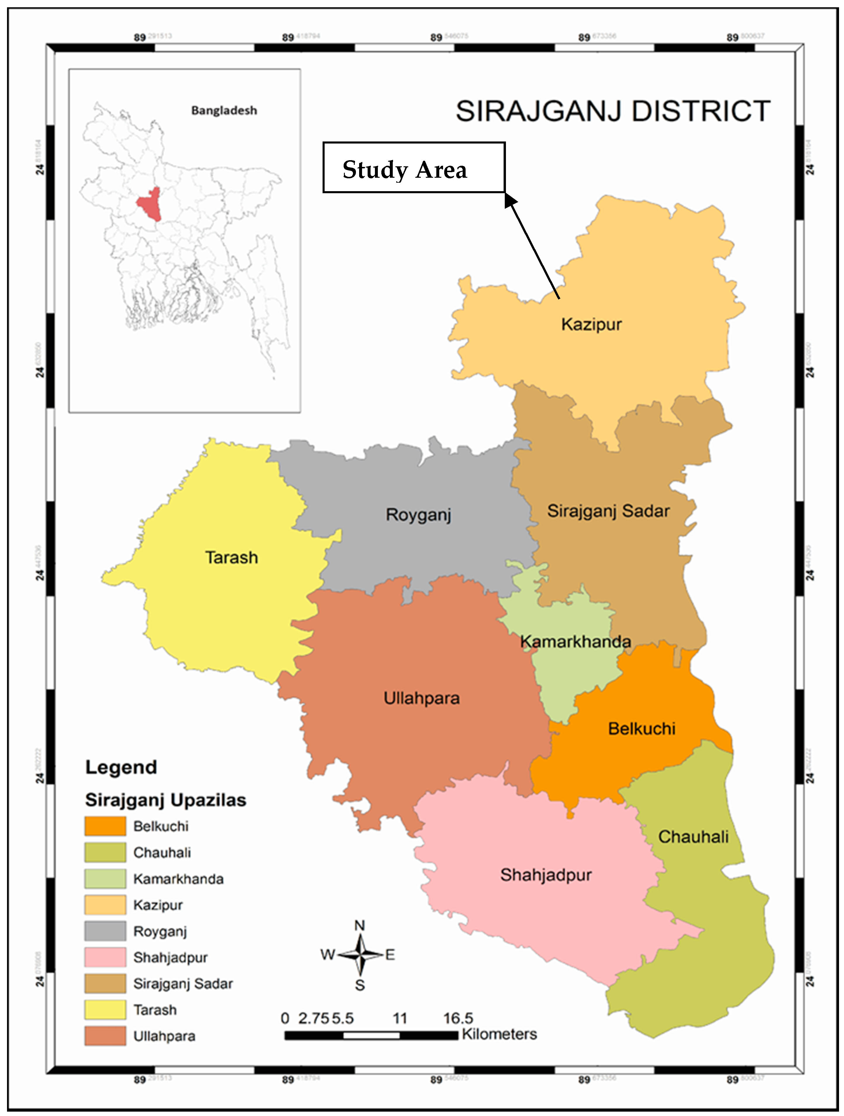
2.1. Study Area

Kazipur Upazila (Riverine Ecosystem) has been selected as the study area as it has been affected by river bank erosion frequently in the last few decades [9]. Kazipur Upazila lies between 24°33′ and 24°47′ North latitudes and 89°33′ to 89°33′ East longitudes (Figure 1). It occupies an area of 328.79 sq. km with a total population of 274,679 (835 per sq. km), whilst around 69,664 households live with an average family size of 3.94 [10].

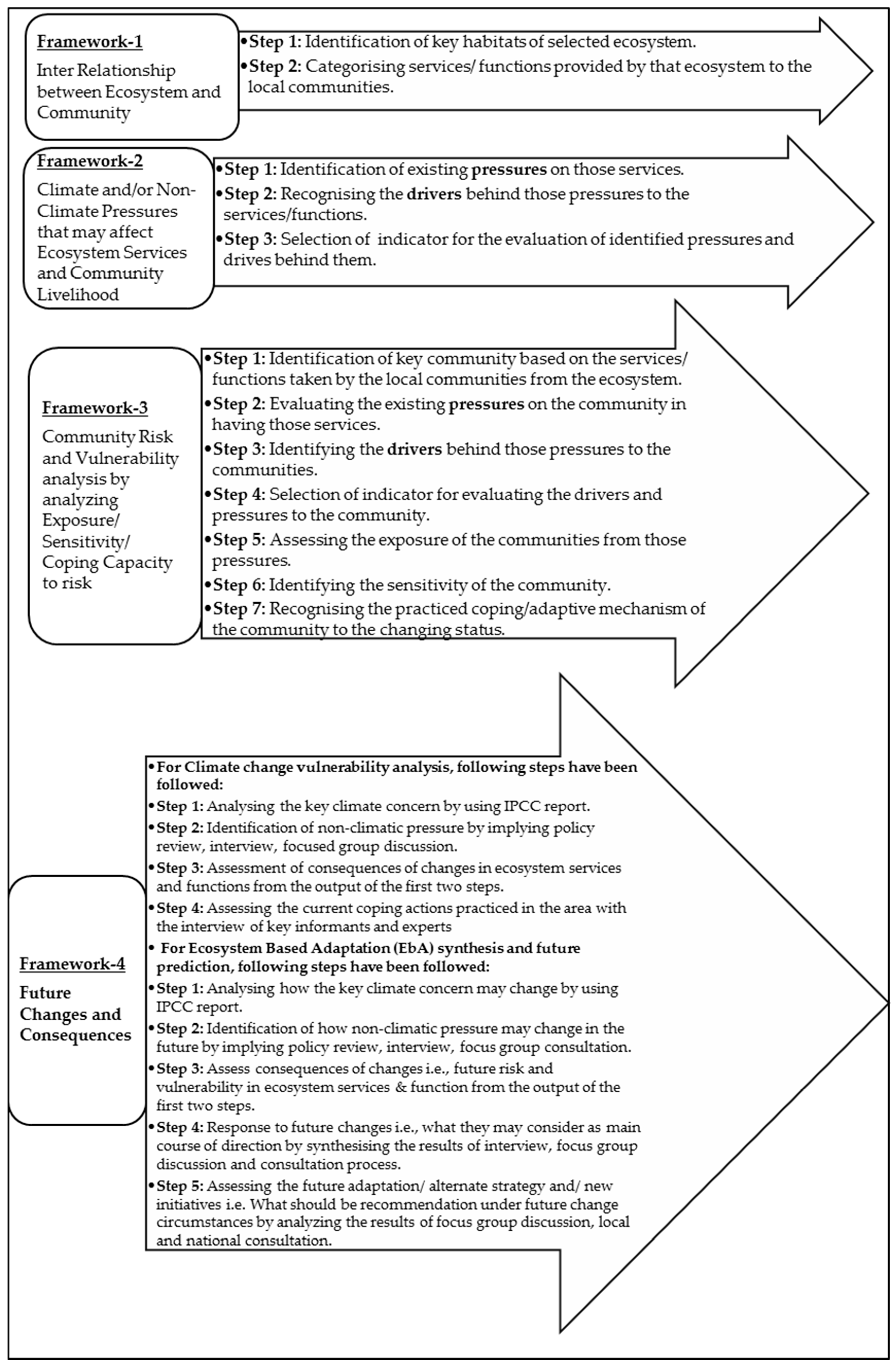
2.2. Methodology of VIA and EbA

The Driver–Pressure–State–Impact–Response (DPSIR) framework has been used to assess the vulnerability and ecosystem based adaptation in the context of a river bank erosion prone area of Bangladesh. The DPSIR framework is based on the four different sections. The layout of the DPSIR framework has been given in Figure 2 with illustration. After the selection of a geographic location based on the probability of river erosion, conceptual Framework-1, Framework-2 and Framework-3 have been prepared by an extensive literature review and consultation process with field experts. Then, the VIA has been conducted using the evaluated and assessed information from the first three frameworks. From the output of the VIA analysis, finally, EbA have been synthesised by considering the possible future effects of identified pressures and drivers to evaluate the best possible adaptive mechanism for maintaining or enhancing the ecosystem integrity through the local level and national consultations. Assessed information has been demonstrated through field assessment by applying some participatory tools such as Key Informants Interviews (KI), Focused Group Discussions (FGD) and Household Surveys (HH).

2.3. Data Collection and Analysis

Primary information relevant to this study has been collected through Household Surveys (n = 100), Key Informant Interviews (n = 30) and Focus Group Discussions (n = 10) from the study area. The key informants were the experts of the relevant field, district agricultural officers (for agricultural data), fishery officers, and the experts from non-governmental organisations. FGD members have been selected from the stressed communities whereas houses were selected randomly for the household survey. Household surveys have been conducted on a random basis using close and open-ended structured questionnaires. Data on factors such as temperature, rainfall, river erosion/land degradation have been gathered from the Bangladesh Meteorological Department (BMD), Bangladesh Bureau of Statistics (BBS), the Local Government and Engineering Division (LGED), Planning Division and relevant websites. Thirty years (1981–2010) annual mean temperature and total rainfall of Bogra station (24°51′N, 89°22′E) have been used for climatic data interpretation in this study. The collected information from the above-mentioned primary and secondary sources has been used to prepare Section 3.1Section 3.4.

2.4. Vulnerability Assessment

The vulnerability assessment identifies the areas of un-sustainability, available specific capacities and potential responses of vulnerable people in the context of exposure in particular locations [6]. In assessing the VIA and EbA, it is required to connect causes (drivers and pressures) to environmental consequences (states and impacts), adaptation and mitigation responses to climate change [6]. Therefore, a conceptual framework for the inter-relationship between ecosystems and communities has been taken into consideration (Figure 3). This inter-relationship entails how the human society flourishes and puts pressure on surrounding ecosystems by exploiting goods and services in an unsustainable way.
The goods and services act as the main drivers of the living system of local communities, and ultimately these drivers start putting pressures on human society and threaten the livelihood of communities. The DPSIR framework makes it possible to formalise all policy-making and management processes by identifying cause and effect links between the elements of a chain of human–environment interactions and also emphasises the interaction between society (human activities in the river) and the environment in integrated river basin management [12].

3. Results and Discussion

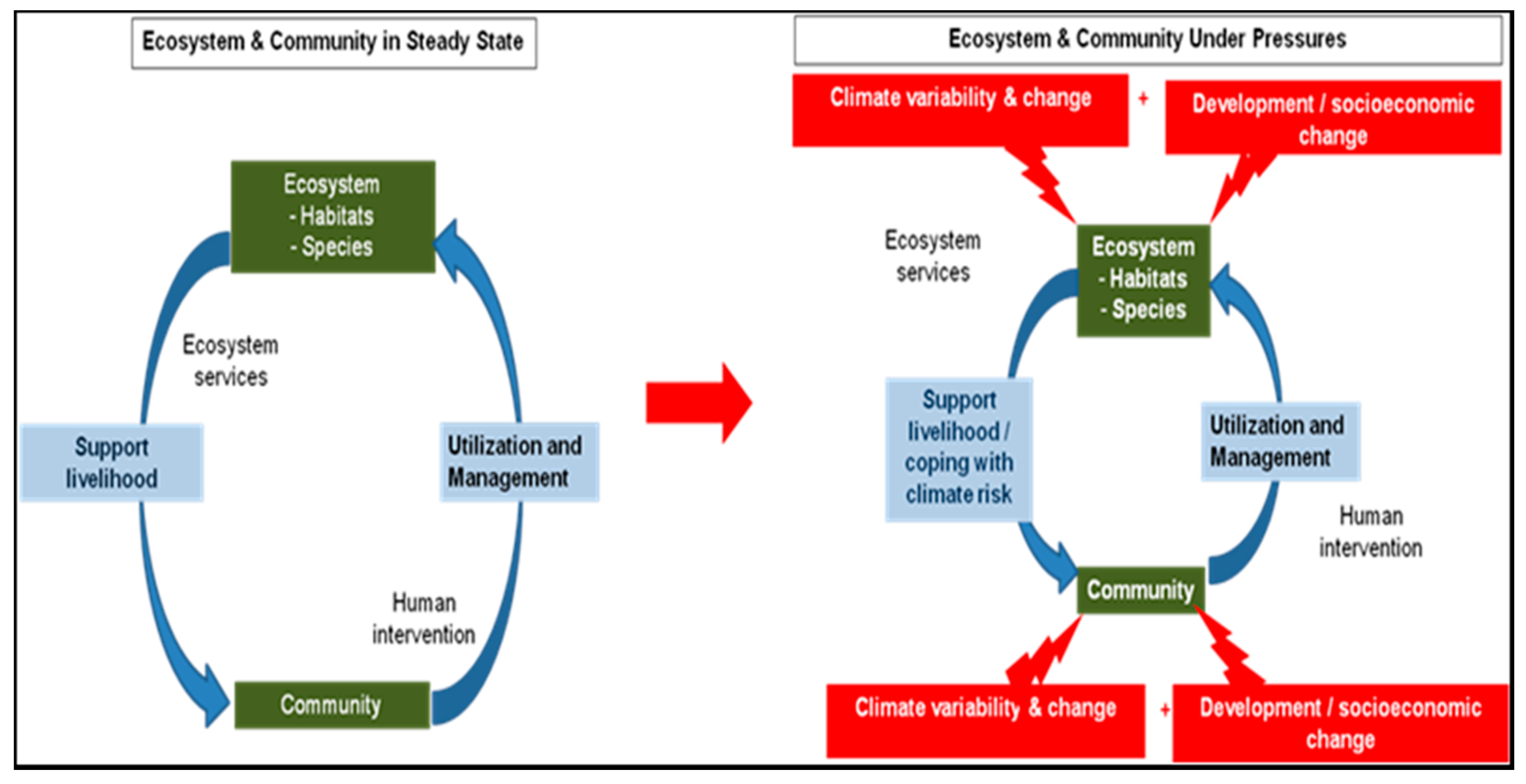
3.1. Ecosystem and Community Interrelationship

Agricultural land has been determined as the key habitat of a selected ecosystem and is a vital resource for rural areas and bank line people of the study area. The study area has 22,708 and 2720 hectares of the cultivated land and settlement, respectively [13]. This agricultural land is mostly used for cropping practices which cover 61.69% of total land features. Accordingly, almost 48% of the total population lives on agriculture [14], and the local community directly or indirectly depends on agricultural practices. The river is another key habitat which covers 21.57% of the area and provides nutrients to the local community. Nevertheless, river erosion makes these communities more vulnerable, because the river has huge silt deposition during low flow conditions which elevates the riverbeds every year, causing a higher risk of flooding and breaching of dykes (9.35%), whereas major areas fall under the category of medium to low vulnerability (65.6%) (Table 1).

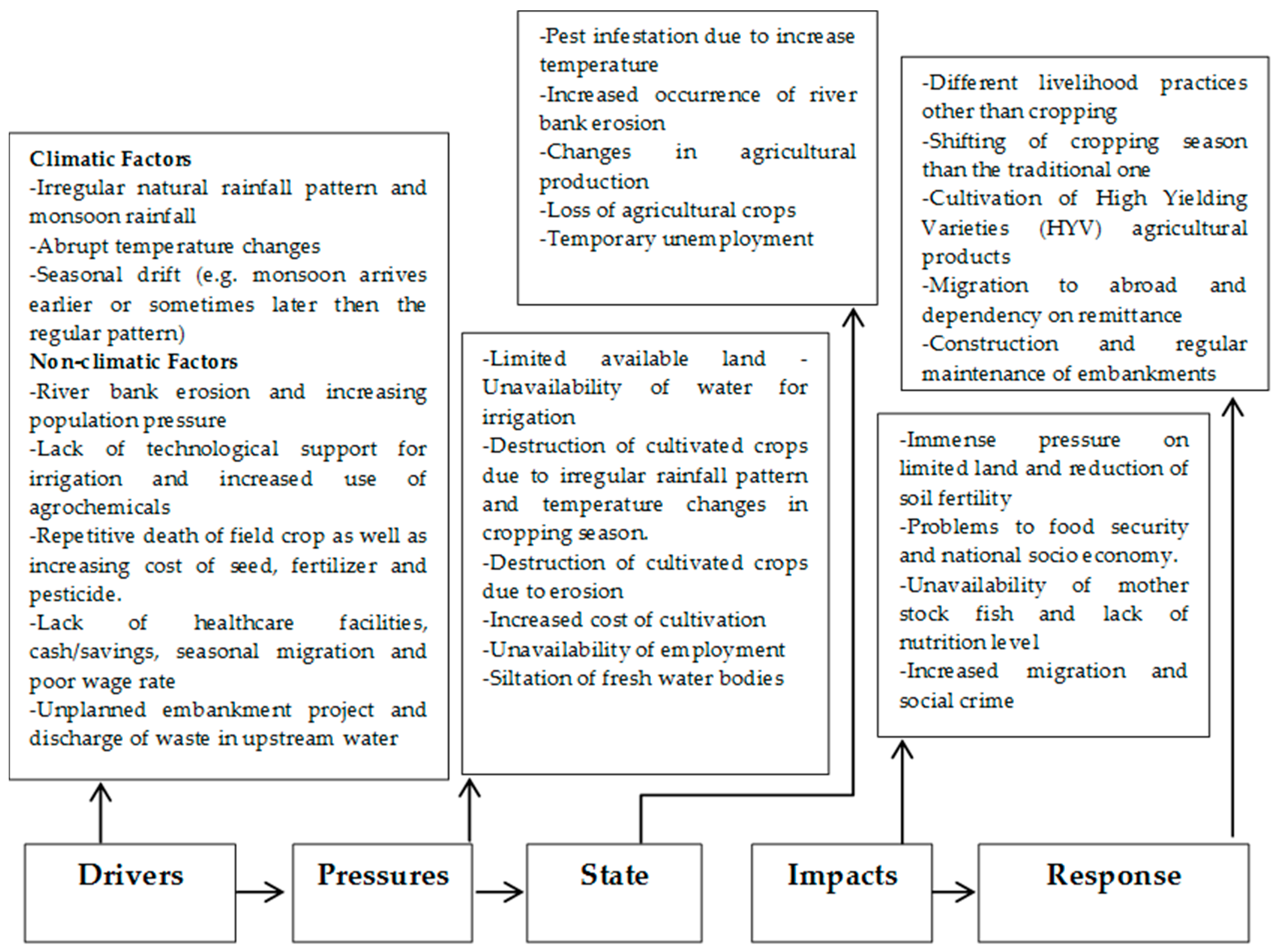
3.2. Climate and/or Non-Climate Pressures to Ecosystem and Community Services

Both the climate and non-climate factors may create pressures to the identified key habitats of agricultural land and water bodies, whereas crop farmers, wage labourers, and riverine people are the key vulnerable communities. The pressures and drivers on the identified habitat and vulnerable communities are given in Table 2.
In recent years, due to river bank erosion and frequent flooding, the destruction of cultivable land, homestead gardens, trees, road communication and the siltation of fresh water bodies have become a very common feature in this area. Excessive monsoon rainfall may be the cause of increased river bank erosion and flood, which results in the loss of ecosystems and biodiversity. The major problem related to agricultural land is the limited availability of land for cultivation in contrast to increasing population and river bank erosion. The rate of river erosion is high when the river is flowing fully, and the intensity of erosion is, however, less when it overflows the embankments. The dykes contribution to the increasing rate of river erosion, as well as sedimentation, has also been identified as a threat for losing agricultural land in the study area [15]. On the other hand, an unpredictable, increasing trend of population extends the food demand which invites the excessive use of fertiliser and chemicals to increase agricultural production, ultimately reducing the land fertility.
River siltation, due to the upstream erosion, is another major threat to the river ecosystem of this area. The main river Jamuna and its branches have also been dried out and have lost their navigation due to the natural heavy sedimentation process and the construction of Jamuna Bridge. Due to inadequate technological support, most of the farmers of this region have to depend on the natural rainfall pattern. The total annual rainfall and total maximum rainfall data from 1981 to 2015 at nearby Bogra station shows an irregular pattern (Figure 4 and Figure 5). The irregular pattern of rainfall sometimes causes the death of field crop due to drying. In contrast, an increase in monsoon rainfall leads to flooding in this region, which may cause the loss of standing field crop just before the harvesting season. At the same time, the changes of temperature have been analysed from the period of 1981 to 2015. Mean annual temperature trends show increases, along with an abrupt decrease in some cases (Figure 6). In addition, the maximum temperature trend shows a widely threating scenario (Figure 7).
Consequently, the unexpected temperature and rainfall scenario may be the cause of increased pest infestation. The repetitive deaths of countryside crops and the mounting cost of seeds, fertilisers and pesticides have enlarged the costs of irrigation. As a result, the cost of new or supplemental water resources (wells, dams, and pipelines), agricultural inputs and production has become higher than ever. A literature review indicates that in recent years, due to sudden fog in the flowering season, the late arrival of rainfall in the sowing season and the low temperature of winter are causing infertility of Boro rice. Alternatively, inadequate health care facilities, lack of cash or savings, lack (ownership) of cultivable land, unavailability of work during Boro and Aman seasons, seasonal migration, poor wage rate, high temperature/heat (summer months) and cold (during winter months) waves are common problems that put pressures on agricultural labourers.

3.3. Community Risk and Vulnerability Analysis

The present study area was the active Brahmaputra-Jamuna (AEZ-7) floodplain, and it encompasses the belt of unstable alluvial land along with the Brahmaputra-Jamuna River, where the land is continually being formed and eroded by shifting river channels. In this area, river flooding is the most dominant hazard, and people are facing riverbank erosion and floodwater inundation during monsoons. These phenomena damage their homestead, livestock, agriculture crop, livelihood, drinking water availability, sanitation, and health. Unpredictable river bank erosion is the main community risk and is creating pressures to the key communities such as agricultural farmers, crop farmers and wage labourers. The key communities are now at the risk of vulnerabilities regarding increased sedimentation and erosion rate, irregular rainfall pattern, abrupt temperature changes and increased use of agrochemicals as well as pest invasion. The vulnerabilities of the study area have been depicted from the DPSIR framework (Figure 8). Therefore, the current risk and vulnerabilities of the study area have been given in Table 3. Consequently, riverbank erosion is the most commanding peril for agriculture practices because 178.76 hectares of land was eroded in 2011 [9], and many of the ancient inhabitations have been rendered extinct by riverbank erosions. Moreover, the study area has also suffered from heat waves during summer, and in the last decade a new natural hazard, namely cold waves, have added to their sufferings [16]. Also, ground water levels have declined due to increased evapotranspiration which depletes the moisture and diminishes the organic matter from the topsoil. In response, to reduce the erosion of the study area, the Jamuna-Brahmaputra flood protection dam, known as the Water and Power Development Authority (WAPDA) dam, was built in 1960 on the west side of the Jamuna. However, it could not help much to resist river erosion nor control flooding, but it helped much in irrigation [16].

3.4. Future Changes and Consequences to the Riverine Ecosystem

Future changes and consequences of the selected ecosystem have been depicted, from climate change vulnerability and ecosystem-based adaptation synthesis. Variations in the rainfall pattern and abrupt temperature changes make the ecosystem more vulnerable. On the other hand, population expansions, excessive use of chemicals and fertilisers and upstream water pollution have been identified as the key non-climatic concern for the study area. Both these climatic and non-climatic concerns create immense pressure on the limited available land and water bodies which will ultimately affect the national economy.
Climatic and non-climatic concerns and the consequences due to the changes in ecosystem functions are given in Table 4. In the study area most of the people are heavily dependent on agricultural land in terms of primary and secondary occupation; therefore, a very little loss in cultivable lands puts the marginalised people into a more vulnerable situation. Consequently, due to erosion, a vast area of agricultural land goes into the river, and such a loss makes them ultra-poor and provides a hindrance to having a normal livelihood [9]. The severe impact of bank erosion is the loss of homesteads which makes people more vulnerable to living an economically sustainable life, because when erosion strikes they are left with no option that does not bear losses. Apart from these losses, bank erosion reduced the opportunity of employment which is one of the most indirect impacts of a disaster. Due to a lack of experience and skill, they can neither shift to secondary occupation nor remain involved in the primary occupation. In such a situation, they have to migrate temporarily to the nearby headquarters or the big cities for job opportunities.

3.5. Suggested EbA in Response to Studied Ecosystem

The key habitats and the dependent communities are vulnerable to various forms of climatic and non-climatic pressures, which demand a range of EbA measures to protect the ecosystem from continuous degradation. In this section, a number of possible adaptation measures have been suggested for reducing the key vulnerabilities to the ecosystem based on current and potential future consequences. Therefore, vegetables, flowers, and seedlings can be grown using a floating cultivation technique without any additional irrigation or chemical fertiliser [17]. Cover crops can be used to upsurge nutrient efficiency which can reduce soil erosion and increase the fertility of cropping land [18]. On the other hand, Integrated Pest Management (IPM), instead of chemical pesticides, can reduce the use of agrochemicals and has the potentiality to increase crop production [19]. Reforestation of the river bank with local species may increase resilience to flooding and reduce bank erosion through sustainable grassland management. Moreover, short durable and flood tolerant species may be introduced into riverine habitats which can enhance the ability of farmers to cope with variable climatic conditions [11]. Additionally, a major factor of crop failure is poor weather information dissemination among the farmers; therefore, an agro-weather forecasting system (warning of the flash flood) may be introduced to assure the minimal loss of standing mature crops and properties to the affected communities. In addition, in order to reduce the pest infestation, instead of Boro, a new suitable variety can be introduced and cultivated with the help of scientists and local experts.

4. Conclusions

The DPSIR framework found that both the climatic and non-climatic factors are contributing towards the vulnerability of the ecosystem and community. The climatic data show the slightly increasing trend in annual mean temperature and decreasing trend in total rainfall over the last three decades (1981–2015). The study found that river bank erosion, increasing population, elevated use of fertilisers and agrochemicals, siltation of land, lack of technological support for irrigation, the irritating pattern of temperature and the late arrival of monsoon rainfall, excessive monsoon rainfall, land-use changes and flow alterations are the major driving forces in the riverine ecosystem. On the other hand, limited available land, reduction of land fertility, river bed siltation due to upstream erosion, unavailability of water for irrigation, destruction of standing crop, the increased cost of cultivation and unfavourable climatic factors for cultivation are creating pressures on agricultural land, water availability and ecosystem services. All these drivers have changed the agricultural production and livelihood pattern of affected communities and put forth problems to food security and socio-economic conditions. Based on the DPSIR framework, this study recommends floating bed cultivation, use of cover crops, flood tolerant species, integrated pest management, reforestation, an agro-weather forecasting system and the introduction of a new variety of EbA to alleviate the possible adverse impacts of climate change confronting this part of South Asia.

Acknowledgments

The authors are grateful to the Ministry of Science and Technology, Government of People’s Republic of Bangladesh for financial assistance. We are also thankful to the authorities of BMD, BSS, LGED, Jahangirnagar University (Department of Environmental Sciences), different NGOs and local people for their support to complete the study. This paper has been benefited enormously from the constructive comments of three anonymous reviewers and the editorial board.

Author Contributions

All authors contributed extensively to the work presented in this paper. Syed Hafizur Rahman designed the overall study and provided instruction in all the process of writing the article. B. M. Refat Faisal critically analyzed the field data to find out the outcome of the study and wrote the paper. Md. Towfiqur Rahman performed field survey and collected relevant information. Toiaba Binta Taher helped in developing methodology section. All the authors discussed the results and implications and commented on the manuscript at all stages of preparing the article.

Conflicts of Interest

The authors declare no conflict of interest.

References

  1. EEA (European Environmental Agency). Environmental Indicators: Typology and Overview; Technical Report No. 25; EEA: Copenhagen, Danmark, 1999. [Google Scholar]
  2. Khajuria, A.; Ravindranath, N.H. Climate change vulnerability assessment: Approaches DPSIR framework and vulnerability index. J. Earth Sci. Clim. Chang. 2012, 3. [Google Scholar] [CrossRef]
  3. Rahman, S.H.; Ferdous, Z.; Islam, S.T. Vulnerability and impact assessment to climate change and ecosystem based adaptation in a drought prone area of Bangladesh applying DPSIR framework. Jahangirnagar Univ. Environ. Bull. 2014, 3, 69–82. [Google Scholar]
  4. Gari, S.R.; Newton, A.; Icely, J.D. A review of the application and evolution of the DPSIR framework with an emphasis on coastal social-ecological systems. Ocean Coast. Manag. 2015, 103, 63–77. [Google Scholar] [CrossRef]
  5. UNISDR (United Nations Office for Disaster Reduction). Global Assessment Report on Disaster Risk Reduction: Risk and Poverty in Changing Climate-Invest Today for a Safer Tomorrow; United Nations: Geneva, Switzerland, 2009. [Google Scholar]
  6. Bizikova, L.; Bellali, J.; Habtezion, Z.; Diakhite, M.; Pinter, L.; UNEP (United Nations Environment Programme). Vulnerability and Impact Assessments for Adaptation to Climate Change (VIA Module); IEA Training Manual; UNEP: Nairobi, Kenya, 2009. [Google Scholar]
  7. CBD (Convention on Biological Diversity). Fourth National Report (Biodiversity National Assessment and Programme of Action-2020); Government of the People’s Republic of Bangladesh: Dhaka, Bangladesh, 2010.
  8. Spangenberg, J.H. Biodiversity pressure and the driving forces behind. Ecol. Econ. 2007, 61, 146–158. [Google Scholar] [CrossRef]
  9. Uddin, A.F.M.; Basak, J.K. Effects of Riverbank Erosion on Livelihood; Unnayan Onneshan-The Innovators: Dhaka, Bangladesh, 2012. [Google Scholar]
  10. BBS (Bangladesh Bureau of Statistics). Community Report Sirajganj, Population and Housing Census 2011; Government of People’s Republic Bangladesh: Dhaka, Bangladesh, 2012.
  11. ECCO (Bangladesh Environment and Climate Change Outlook-2012). Available online: http://www.doe-bd.org (accessed on 10 September 2013).
  12. Kagalou, I.; Leonardos, I.; Anastasiadou, C.; Neofytou, C. The DPSIR approach for an integrated river management framework. A preliminary application on a Mediterranean site (Kalamas River-NW Greece). Water Resour. Manag. 2012, 26, 1677–1692. [Google Scholar] [CrossRef]
  13. Mollah, T.H.; Baten, M.A.; Titumir, R.A.M. Accounting Climate Induced Migration in Bangladesh: An Exploratory GIS Based Study; Unnayan Onneshan: Dhaka, Bangladesh, 2011. [Google Scholar]
  14. BBS (Bangladesh Bureau of Statistics). Preliminary Report on Household Income and Expenditure Survey 2010; Government of People’s Republic Bangladesh: Dhaka, Bangladesh, 2011.
  15. IPCC (Intergovernmental Panel on Climate Change). Climate change: Impacts, Adaptation and Vulnerability, Contribution of Working Group II to the Fourth Assessment Report of the Intergovernmental Panel on Climate Change; Cambridge University Press: Cambridge, UK, 2007. [Google Scholar]
  16. Seal, L.; Baten, M.A. Reckoning Climate Change: Local Peoples’ Perception on the Impacts of Climate Change in South-Central and the Impacts of Climate Change in South-Central and Northern Bangladesh. Available online: http://www.unnayan.org (accessed on 23 November 2012).
  17. Hossain, M.A. Floating cultivation: An indigenous technology for adapting to water logging situation towards sustainable livelihood security in the low lying areas of Bangladesh. J. Biosci. Agric. Res. 2014, 1, 54–58. [Google Scholar]
  18. Hoorman, J.J. Using Cover Crops to Improve Soil and Water Quality; Ohio State University Extension: Lima, OH, USA, 2009. [Google Scholar]
  19. BARC (Bangladesh Agricultural Research Council). Land Degradation Situation in Bangladesh; Soil Division, Bangladesh Agricultural Research Council: Dhaka, Bangladesh, 1997.
Figure 1. Location map of the Sirajganj District.
Climate 04 00052 g001
Figure 2. Layout of the DPSIR framework methodology.
Climate 04 00052 g002
Figure 3. Conceptual framework of the inter-relationship between ecosystem and community [11].
Climate 04 00052 g003
Figure 4. Trend of total annual rainfall (mm) of Bogra station (1981–2015).
Climate 04 00052 g004
Figure 5. Trend of total maximum rainfall (mm) of Bogra station (1981–2015).
Climate 04 00052 g005
Figure 6. Trend of annual mean temperature (0 °C) of Bogra station (1981–2015).
Climate 04 00052 g006
Figure 7. Trend of maximum temperature (0 °C) of Bogra station (1981–2015).
Climate 04 00052 g007
Figure 8. Assessment of vulnerability by applying the DPSIR framework.
Climate 04 00052 g008
Table 1. Land features and vulnerable areas in study area [12].
IssuesArea in HectaresPercentage (%)
Land Features
Settlement27207.39
Agricultural Land22,70861.69
River794121.57
Eroded Area34439.35
Vulnerable Areas
High Vulnerable Area470112.77
Medium Vulnerable Area10,65628.95
Low Vulnerable Area13,49336.65
Table 2. Key habitat, vulnerable community, pressures on the ecosystem and drivers in the study area.
Vulnerable CommunityPressuresDrivers
Non-ClimaticClimatic
Key Habitat-Agriculture Land
Crop Farmers
-
Limited available land
-
River bank erosion
-
Increasing population pressure
-
Reduction of soil fertility
-
Elevated use of agrochemicals
-
Siltation of land
-
Unavailability of water for irrigation
-
Abrupt temperature changes
-
Lack of technological support for irrigation practices
-
Dependency on natural rainfall pattern for irrigation and seasonal drift.
-
Reduced temperature in the sowing season has impacts on the crop vernalisation.
-
Destruction of cultivated crops
-
Increased use of pesticide has made the pest potent against chemical
-
Increased temperature and the late arrival of monsoon rainfall may create pest infestation.
-
Increased cost of cultivation
-
The repetitive death of field crop as well as increasing the cost of seed, fertiliser and pesticide
-
The high price of agricultural inputs
-
Repeated death of seedlings resulted in a lack of irrigation water due to irregular rainfall in the sowing season of the crop.
-
Destruction of cultivated crops
-
The late arrival of monsoon rain causes the death of seedlings due to lack of irrigation.
Agricultural Labourers
-
Shortage of labourer opportunities
-
Lack of healthcare facilities, cash/savings and cultivable land
-
Unavailability of work
-
Seasonal migration and poor wage rate
-
High temperature/heat (summer months) causing health problems such as heat stroke.
-
Cold (during winter months) virtually no cultivation takes place.
Wage Labourer
-
Unavailability of employment
-
Poor wage rate and gender disparity.
-
Lack of health care facilities and savings
-
High temperature/heat (summer months)
-
Cold (during winter months) waves
Key Habitat-Water Bodies(River)
All communities especially those who live along the river bank
-
Loss of valuable land and homestead
-
River bank erosion
-
Flooding
-
Excessive monsoon rainfall and late arrival of monsoon rain
-
Infestation of communicable diseases due to high temperature
-
Cold wave creates diseases to the poor people
-
Destruction of Biodiversity
-
Increased river bank erosion
-
Loss of cultivable land
-
Destruction of agricultural land and road communication
-
Increasing river bank erosion
-
Flooding
Communities living in the area
-
Siltation of fresh water bodies
-
Embankment project causes siltation
-
Excess practices of agriculture due to shortage of cultivable land
-
Pollution of water bodies
-
Indiscriminate use of agrochemicals in the upstream
-
Discharge of waste in upstream water
Table 3. Current risk and vulnerabilities of the study area.
CommunityPressuresVulnerabilityCoping Capacity
IndicatorsRemarks
Agricultural FarmerLimited availability of landIncreased sedimentationIntegrated Protected Area Co-management (IPAC) report (2009) has also identified sedimentation as threats for losing agricultural land.
-
Alternative livelihood practices other than cropping practices.
-
The propensity to migrate in abroad and increased dependency on remittance.
-
Shifting away from the traditional cropping season.
-
Migration to the urbanised area for livelihood income
-
Cultivation of HYV
Reduction of land fertilityIncreased use of chemicals and fertiliserPopulation expansion extends the food demand which invites the elevated use of fertiliser and chemicals to increase production, ultimately reducing the land fertility.
Crop FarmerIncreased rate of erosionErosion rate Mollah et al., 2011 reported the erosion rate of 9.35%.
Unavailability of water for irrigationIrregular monsoon rain and rainfall patternIn recent years their irregular pattern of monsoon rainfall has been noticed, which causes the death of standing field crop just before the cutting season.
Destruction of standing cropIncreased pest invasionIncreased temperature and the late arrival of monsoon rainfall have been observed.
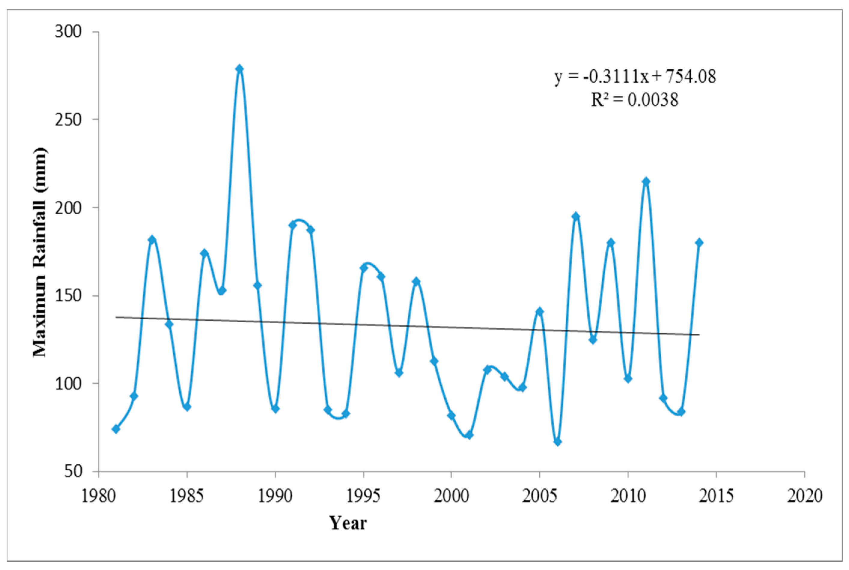
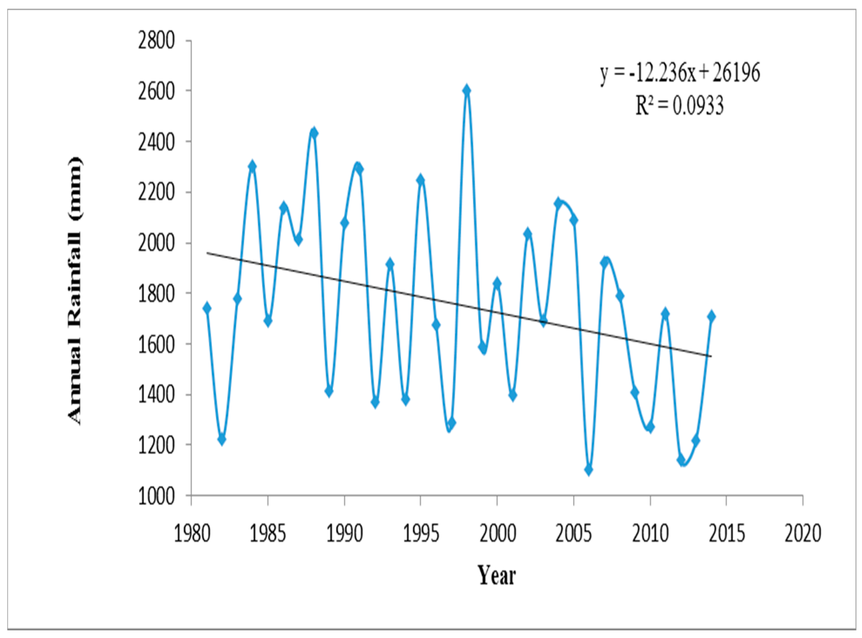
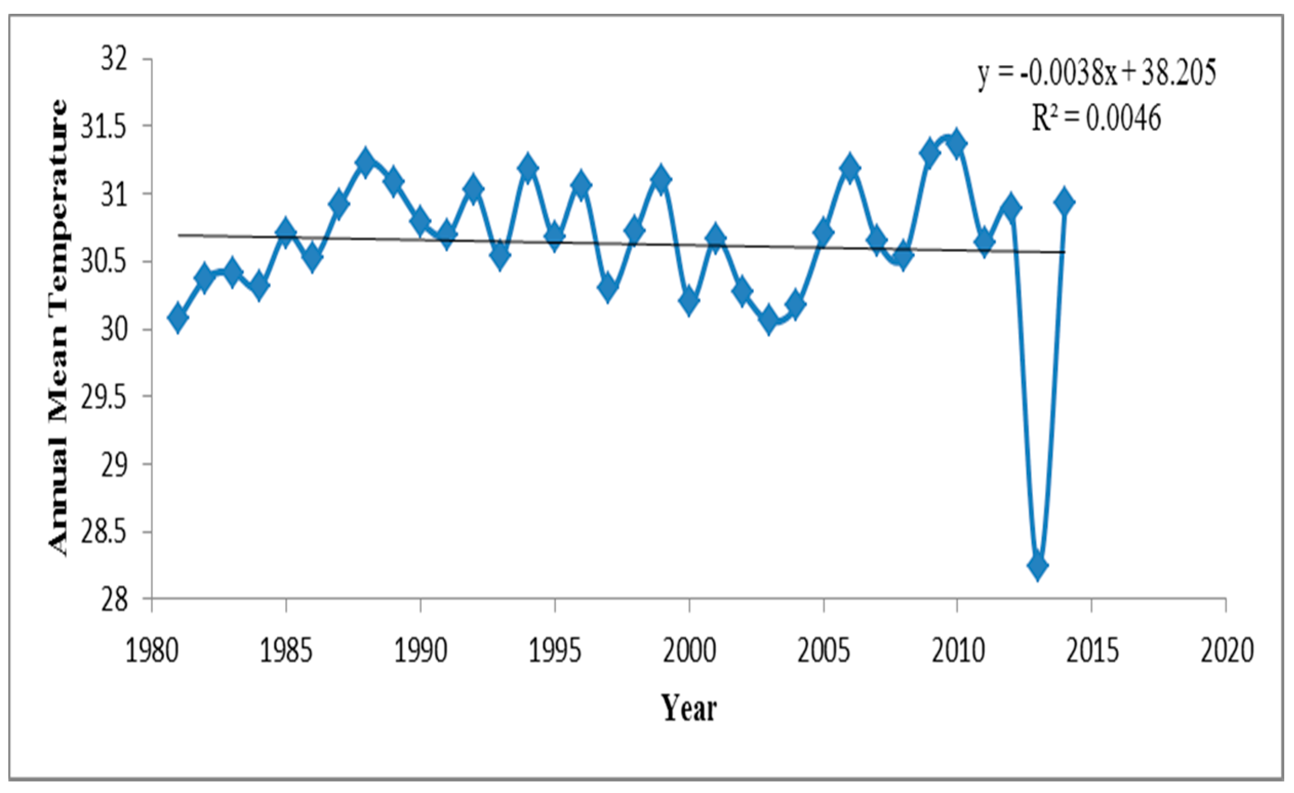
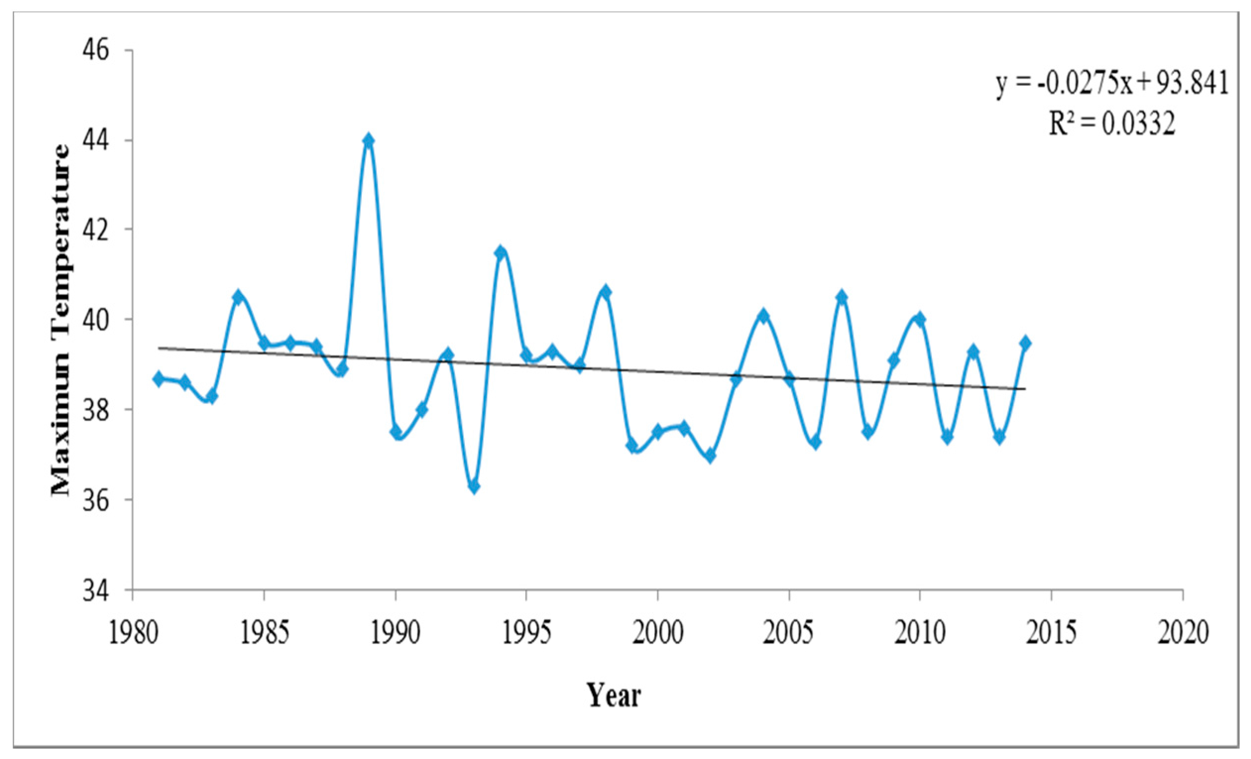
Unfavourable climatic conditionSudden fog in flowering season and abrupt changes in rainfall and temperatureSudden continuous fog for several days in the flowering season is causing the infertility of Boro rice.
Abrupt changes in the rainfall pattern and temperature over the Bogra station (1981–2015) have been given in Figure 4, Figure 5 and Figure 6.
Wage LabourerUnavailability of employmentLack of cultivable land and poor wage rateLoss of cultivable land has decreased the employment opportunity of many wage labourers and aggravated the changing of livelihood pattern.
Table 4. Assessing the consequences of changing climatic conditions and possible threats.
Key Habitat and ServicesKey CommunityKey Climate ConcernsNon-Climate ConcernsConsequences
Agricultural ProductsLand
Land for crop cultivationFarmers
-
The climatic data of rainfall and temperature of Bogra station (1981–2015) shows abrupt changes which indicate an increasing risk.
-
Virtual certainty of increasing pests (in the case of the crop) due to an abrupt temperature change trend.
-
Agricultural drought due to a lack of rainfall and increased temperature in the summer season.
-
Decreasing minimum temperature at winter will lead to crop destruction.
-
An increased temperature regime reveals virtual certainty of an increased likelihood of tornados in the upcoming days.
-
Population expansion will certainly reduce per capita land area.
-
Excessive use of chemical fertilisers will increase pest infestation.
-
Immense pressure on limited land will reduce soil fertility.
-
Reduced agricultural production and land availability will lead to jeopardised food security and will increase poverty level by increasing the unemployment rate which will ultimately affect the national economy.
Water Bodies (River)
Water feeder of the ecosystemAll communities
-
Virtual certainty of increasing rainfall within a short period will increase the river erosion upstream thus leading to siltation.
-
Upstream pollution will threaten the aquatic biodiversity and water quality.
-
Siltation of the river will ultimately lead to the destruction of this ecosystem.
Natural source of fishFishermen community
-
Effects fish spawning for the late arrival of a monsoon which will lead to reduced fish availability.
-
Increased temperature will result in hydrological droughts which will affect the aquatic biodiversity.
-
Destruction of mother stock of fish will impact the availability of fish species throughout the country and in turn will affect the national economy.
-
Virtual certainty in siltation of water by river erosion upstream due to excessive soil erosion because of an increasing trend of monsoon rainfall.
-
Virtual certainty of upstream pollution of river water and construction of embankment/polder without planning.
-
Excessive use of fertiliser in the upstream vegetation will pollute the water quality thus affect the fish diversity.
-
Reduction in fish species will create pressure on the food security and nutritional level of the local poor.

