Climate and Production: The Case of the Administrative Region of Grande Dourados, Mato Grosso do Sul, Brazil
by
 ,
,
André Geraldo Berezuk
1 ,
,
Charlei Aparecido da Silva
2,*,
Lisandra Pereira Lamoso
3,4 and
Heverton Schneider
5 1
Department of Geography of UFGD, Federal University of Grande Dourados, Dourados 79825-070, Brazil
2
Faculty of Human Sciences, Department of Geography, Federal University of Grande Dourados, Itahum Road, km 12, Dourados, MS 79804-970, Brazil. Physical Geography Laboratory
3
Department of Geography of UFGD. Social-Economic-Environmental Group of Mato Grosso do Sul State, Mato Grosso do Sul 79000-000, Brazil
4
The Department of Geography of UFGD, Mato Grosso do Sul 79000-000, Brazil
5
Physical Geography Laboratory, Federal University of Grande Dourados, Dourados 79825-070, Brazil
*
Author to whom correspondence should be addressed.
Climate 2017, 5(3), 49; https://doi.org/10.3390/cli5030049
Submission received: 28 April 2017
/
Revised: 1 July 2017
/
Accepted: 4 July 2017
/
Published: 8 July 2017
(This article belongs to the Special Issue Studies and Perspectives of Climatology in Brazil)
Abstract
:In the academic literature we can find a wide range of studies in climatology which show that current land management methods are contributing to an increase in environmental impact on the planet. These studies in climatology not only analyze atmospheric data, but also require a wide knowledge of the researcher’s regional interests for territorial planning. This article aims to explain the characteristics and tendencies used in the territory of the administrative region of Grande Dourados, in the state of Mato Grosso do Sul, Brazil, and the environmental implications of this process of land exploration. Then, we analyze several climatological surveys carried out by the physical geography laboratory of the Federal University of Grande Dourados and the socio-economic and environmental research group of Mato Grosso do Sul. The results demonstrate how important it is to develop strong measures to valorize environmental actions in the area. Climatic parameters can also exacerbate more extreme regional climate patterns, an exacerbation that has a strong spatio-temporal aspect, and also has a direct relation to the various climatological scales. This type of research is pioneering work in the state of Mato Grosso do Sul and in Brazil, and it will contribute to further academic work which will discuss the important relations between land production and climate impact in the near future.
1. Introduction
One can consider that studying climatology is a way to achieve better management of human activities in a territory, and the management of territories has been a challenge in the scope of climatology studies in Brazil. Following from this idea, it is clear that understanding regional climate parameters and how the joints of its scales occur are keys for territory management. In fact, we believe that it would be essential at the beginning of 21st century to improve and optimize human actions to prevent natural disasters due to extreme events. More than that, we could also add that studies of regional climatology could help to seek adaptive measures as a function of the climate change scenario.
Even with all the current technical, scientific and informational apparatus, there is a belief in the adaptive limit of human activities related to the characteristics of the climates on the planet. Previous studies and debates on global climate have presented evidence of the importance of understanding potential human activities and their relation to the climate, this means that researchers easily see that there are limits to the relations between society and the climate. These limits are evident when society faces extreme climatic events and, at the same time, we can see concerning patterns in the distribution of the world’s population or the organization and specialization of economic activities, especially those related to agribusiness.
In Brazil, the spatialization and specialization of agricultural production has increasingly taken into account the climatic risk involved in the financing and production processes. As an essential element of the Brazilian trade balance, agricultural production, in form of commodities, incorporates the climate as an essential input, and in Brazil it works in the same way as those developed within government agencies such as the Brazilian Agricultural Research Corporation [1].
We consider that three aspects are essential for studying the climate and its effects on society: understanding climate nuances, their habitual behavior, as well as their exceptionalities. These three aspects play a pivotal role in dealing with global climate change, especially concerning increasing temperatures and changing rainfall patterns on local scales. At the same time, local and micro scales have revealed changes in the climatic parameters, especially in territories where economic activities have led to a great change in their original pattern, either by the emergence of cities or by the removal of the primitive vegetation for agricultural cultivation.
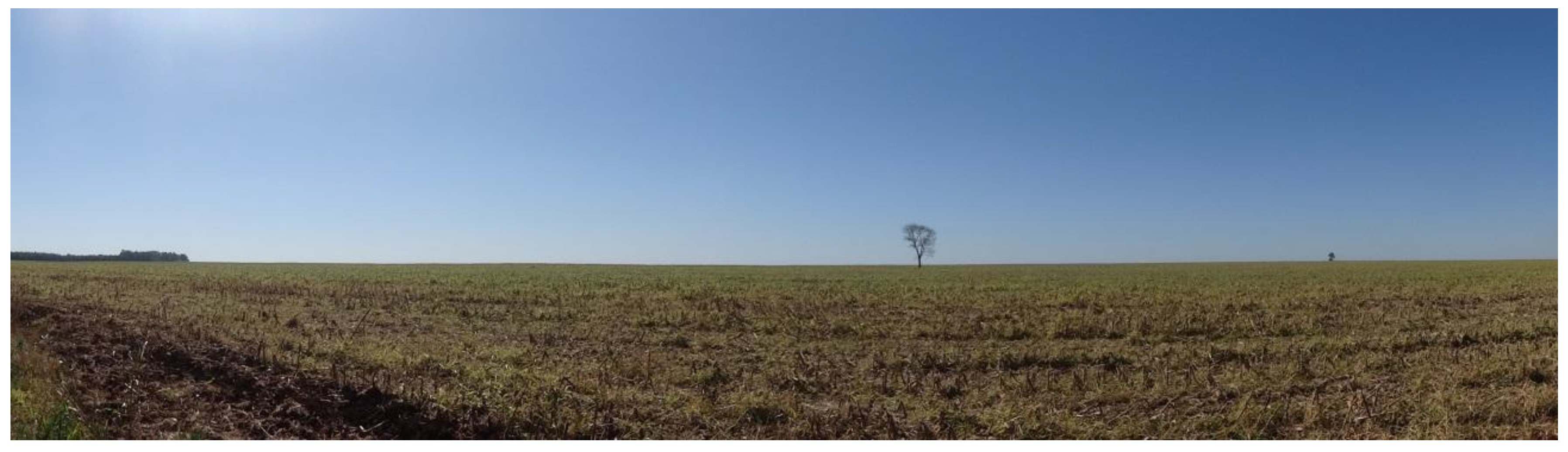
The specific land studied in this paper—the Dourados region, located in the state of Mato Grosso do Sul, Brazil—is a territory with these cited characteristics, marked for the last four decades by the expansion of agribusiness, based on the extensive cultivation of soybean, corn, sugar cane and livestock (Figure 1).
Some regional researchers have demonstrated that this territorial configuration (Figure 1) has a changed regional pluviometric regime [2,3,4,5,6,7], and changed temperature and air quality patterns [8,9,10], with the worsening, even, of the health of the populations of the cities that, in the surroundings, live daily through soybean, maize, sugar cane and livestock commodity production [5,6,8,9,10].
Thus, this paper aims to reveal the temporal and spatial changes in the climatic parameters of the region of Dourados (Mato Grosso do Sul state, Brazil), in order to discuss at what level these climatic changes are interrelated with the modes of production. Moreover, this type of production has been chosen due to the existence of only one development model, based exclusively on the consolidation of monocultural territories, understood here as the cultivation of only a few products—such as soybean, maize, sugar cane and livestock—which are used for large territorial extensions to export commodities. This is a pioneer work within both the study area and within Brazil.
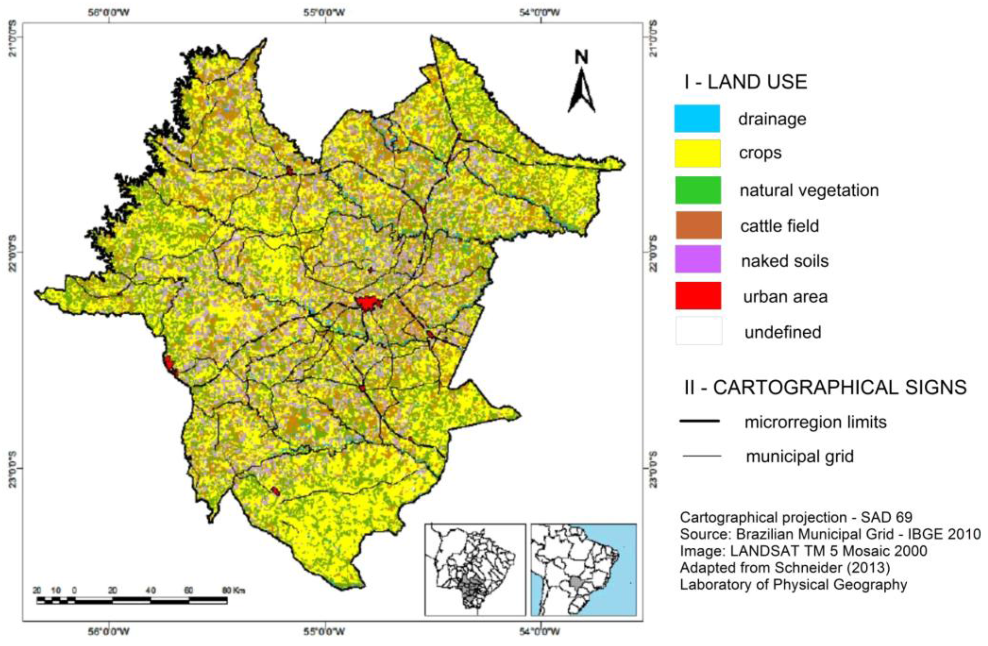
The study area (Figure 2) has a size of 37,359 km2, and an estimated population of approximately 558,403 inhabitants [11]. This area covers 15 municipalities and is the second most populated micro-region in the state of Mato Grosso do Sul. This state is the sixth largest Brazilian state in size (with 357,145 km2, which is equivalent to the size of the United Kingdom or Germany), and has a population estimated at 2,651,000 inhabitants in 2016. It is the 21st most populous Brazilian state and has one of the lowest demographic densities, with approximately 7.4 inhabitants per km2. Thus, the studied area is a place of great agricultural importance in Brazil and fundamental to Brazil’s gross domestic product (GDP).
2. Theoretical Background and Methods
2.1. Agrobusiness and the Mato Grosso do Sul State
In the last forty years, agricultural productivity has increased for many reasons: (a) technical progress, through the use of machines and implements, and automation in planting and cultivation processes and irrigation techniques; (b) genetic improvements with varieties genetically adapted to the geographical conditions; and (c) phytosanitary actions. In addition, we could highlight the adoption of modern transportation standards and logistical efficiency, credit expansion and subsidized resources, as well as the expertise, commitment and qualification of the workforce. We have to take into account the need for knowledge and planning, once we consider that the world population of 7.3 billion people could reach 8.5 billion in the year 2030 [12], as well as considering the social demand for natural resources and food, and reviewing bottlenecks in the redistributive process.
Brazil has 0.8% of its area occupied by permanent crops, 7.5% by arable land, 23.5% by fields and natural pastures, 59.8% by forests and 7.5% by other uses [13]. The challenge for its agricultural production is to increase productivity, without needing to expand into ecosystems that may be socioeconomically profitable, but that currently have native vegetation cover, such as extensive areas of the Amazonian equatorial forest, or the Pantanal, for example [2].
Sugarcane, soybeans and corn are the three largest agricultural products and also constitute the products with the largest participation in the international commodity market in Brazil. The country ranks first in sugar exports (768 million tonnes), followed by India (341 million tonnes) and China (128 million tonnes). The first country in soy grain exports is the United States, followed by Brazil and Argentina. The production of soybean in the United States is higher than in Brazil, with production of 3230 kg/ha, while Brazil produced 2882 kg/ha in the same 2015/2016 crop [14]. Mato Grosso do Sul state has a production of 3108 kg/ha [14]. Regarding the ranks of corn production, Brazil is in the third position, after the United States and China [15]. Brazilian corn production is produced in two harvests: one between August and September, and another between March and July. This production reinforces an extensive marketing and storage chain, which is monopolized by powerful cooperatives and grain trading companies such as Cargill, ADM and Bunge. We should also mention that beef is the most exported product in terms of value in Brazil, surpassing soybeans, maize and sugar.
This panorama of world production indicates the composition of Brazilian agriculture, which is predominantly marked by the production of commodities. The fact is that commodities have two important implications: firstly, more technical, comprising products with standardized characteristics and low added value can be produced, transported and marketed on a large scale, and are governed by prices established in stock exchanges. This market competition is based on the cost of production, instead of the differentiation of products. Therefore, the cost of production is crucial for calculating earned income.
A second implication is that the commodity process assumes knowledge of the notion of competitiveness as a geographic expression of production, related to international quality and cost parameters and corporate circulation [16]. When we are discussing the scale of production and other characteristics, we have a commodity that is not absorbed by the local or regional market, once we take into account a scale of consumption that goes beyond the environment and is invariably tied to international parameters. The commodity requires large-scale production and transportation; prices are set by buyers, and require intensive use of other natural resources. This does not mean that technological development cannot be incorporated. One can understand that even commodity-based economies can drive research and development investment not only in the product itself but also in every chain that involves transport and storage with increasingly modern techniques for efficiency gains. The variation in commodity prices responds directly to international demands, to financial flows and also to the interest of corporations in the sector. “In the commodity-producing spaces the vectors of globalization are intensely present” [17]. It is worth mentioning that grain production is characterized by intensive mechanization, as well as by close dependence on inputs and scientific knowledge, such as the use of genetically engineered seeds. This characterization is used to increase productivity, and it is directly related to world market demands, as well as to the hegemonic groups of the sector, which are characterized as a “globalized scientific agriculture” [18].
We highlight the geographic region of Dourados (Mato Grosso do Sul) in this paper because it presents the characteristics of the large-scale production of maize, soybean and sugar cane. Corn and soybeans were produced in the central south of the state in the late 1960s, sharing space with extensive cattle ranching. By that time, they had replaced the commercial cultivation of yerba mate and, later, rice and some coffee strains. The growth of coffee strains was eliminated after the 1974 frost, which decimated the coffee plantations in the far south of the state.
The expansion of soybean cultivation was determined by a set of factors, such as [19]:
- (1)
- southern migratory flow (gaucho farmers) in the sixties;
- (2)
- the international situation caused by the oil crises (1973 and 1979), which resulted in an internal policy to encourage the production and export of protein (soybean) to the European market, in order to generate foreign exchange that would reduce the impact of fossil fuel costs on the trade balance;
- (3)
- a set of macroeconomic measures that mobilized the efforts of the Brazilian Agricultural Research Corporation (Embrapa) to adapt the center-west for the cultivation of grains;
- (4)
- regional development programs with an emphasis on the allocation of infrastructure to urban centers selected for their pole status consolidation;
- (5)
- agricultural credit policies.
This set of factors was determining for the expansion of grain cultivation throughout the south of what was formerly known as Mato Grosso state and which is currently called Mato Grosso do Sul state [19]. Soybean and corn exported by the state exceeded one third of the total value of exports in 2015, with soy crops responsible for 28%. Exports are destined for the European Union, Southeast Asia and China.
Every region in Mato Grosso do Sul has grain production (corn and soybean), but there is a core area with more specialized production, as evidenced by storage, transport and commercialization, networks, service support, and the improvement of cultivation practices. This region, in the south-west of the state, is represented by the cities of Aral Moreira, Laguna Carapã, Itaporã, Maracaju, Douradina, Caarapó, Dourados and Ponta Porã. There are also important areas in São Gabriel do Oeste, Chapadão do Sul, Sonora (in the north of the state) and Naviraí (in the south-east of the state). In the 2014–2015 harvest, there were regions where more than 50% of the agricultural area was soybean, such as Aral Moreira (64%), Laguna Caarapã (58%) and Itaporã (56%) [19].
Two other representative products of southern Mato Grosso do Sul agribusiness are sugar cane and eucalyptus (eucalyptus is being inserted for the massive production of cellulose). Sugar cane production began its expansion in 2006, in the southern portion of the state, where the ethanol, sugar and biodiesel central plants are concentrated. The percentage of sugar cane gross production of Mato Grosso do Sul is 5.52% of the total national production. The state of São Paulo is the leader, followed by Minas Gerais, Goiás and Paraná. The expansion of sugar cane in the south of Mato Grosso do Sul has contiguity with São Paulo production, is grown in favorable soil conditions, and land is available at a cost lower than that which can be found in the state of São Paulo. The area of cane production is mainly close to these cities: Nova Alvorada do Sul, Rio Brilhante and Angélica.
Eucalyptus cultivation is concentrated in the north-west portion of the state, in the regions of Três Lagoas, Ribas do Rio Pardo, Águas Claras, and Brasilândia. Wood chemical pulp make up 20% of the state’s total exports, and is outside the area of this study.
The four products mentioned (soy, corn, sugar cane and eucalyptus) represent an important part of agribusiness, which bases its productive structure in basic products. However, this mode of production, intrinsically related to the global market, has a high ecological footprint, which can alter the physical configuration of ecosystems and has effective power to modify the climatic configurations of the state of Mato Grosso do Sul.
2.2. Methodology
In this work, dissertations and articles (developed by the physical geography laboratory at the Federal University of Grande Dourados, as well as studies developed by a group of social, economic and environmental researchers of the state of Mato Grosso do Sul) are the main source of results regarding possible regional climatic change that could be related to local land use or the land use of the nearest regions l [2,4,5,6,7,8,9,10]. Since 2011, these studies focused precisely on the dialectic relation between climatology and regional economic production. These materials aim to reach a better understanding of the gradual social–environmental and social–climatic impact on the Dourados region and the south-central region of the state of Mato Grosso do Sul. These publications comprise a wide range of the different types of statistical methods used in climatology (Table 1):
2.3. Climatic Aspects of the Dourados Microregion and the State of Mato Grosso do Sul
The state of Mato Grosso do Sul constitutes an extensive area of Brazilian territory that is in a legitimate area of climatic transition, because of the fact that it constantly suffers from the actions of tropical masses and masses of polar origin, in addition to frontal systems and the South Atlantic convergence zone (SACZ). In fact, twelve climatic units were identified in the Mato Grosso do Sul state due to its natural physical characteristics and latitudinal position. Among the air masses of tropical origin, there is the Atlantic tropical mass (mTa), which has oceanic characteristics, but also often has dry and hot winds from the east and north-east, and the continental tropical mass (mTc), which is an area of barometric depression in the Chaco region caused by the intense warming of the interiors of Paraguay, Bolivia and northern Argentina. In the Dourados region, mTc is responsible for long heat waves and for control of the drought period from June to September. With regard to the polar air masses, the Atlantic polar mass (mTa) is well known, being usually cold and dry with greater performance in the winter period. The clash between the polar and tropical air masses, and their strong convection processes, in turn, cause cold fronts, which are vital for the genesis of rainfall in the state during the course of year, as are the air masses cited. The SACZ (South Atlantic convergence zone) is also important, as it brings the Amazon and Atlantic Ocean humidity that is responsible for the occurrence of convective rains, especially in the months of April, May and June, that is, in autumn. Rainfall averages of around 1500 mm and mean temperatures above 20 °C in almost all months of the year are derived from these systems in association with local factors.
The central and southern parts of Mato Grosso do Sul have a more homogeneous pluviometric rhythm than the northern areas, due to the greater performance of the cold fronts to the south and a more evident orographic process in the central and southern sectors of the region, due to the elevation of the Amambai mountain, an elevation that does not exceed an altitude of 700 m [2,26,27] (Figure 3). However, this region has a greater period of rainfall from October to March and a period of drought from April to September, which is characteristic of a tropical climate very well marked by the rainfall regime. Regarding the temperature, when the predominance of frontal systems is associated with mPa, we can measure daily thermal amplitudes that can exceed 20 °C, if we compare the maximum and minimum reached within twenty-four hours.
The variation of annual rainfall volume is between 1300 mm in the northern sector of this region and over 1700 mm in the Amambai sector [27] (Figure 3), with the presence of regular rainy periods between October and March, followed by drier periods; we can see this as a fundamental factor regarding the presence of properties oriented to agribusiness. Another important factor of the physical configuration of this region is the presence of a low topographic slope of the land, that in general does not exceed 5% [28]. With an appropriate climate and a privileged topography, which encourages the mechanization of crops, the region is one of the most valued regions in Brazil for agribusiness, and therefore for the export of commodities.
3. Results and Discussion
The Dourados region, as well as the south-central state of Mato Grosso do Sul, has undergone a significant landscape transformation, referring to the tropical world, as we can see its modification from primitive vegetation to wide territorial extensions destined exclusively for agriculture and cattle raising. In fact, we can observe various changes in the climate of the area, from the past to the present, from the suppression of the primitive vegetation with its rich biodiversity, to the quality of the regional springs. This process of agricultural occupation and production is similar to the process of colonization of northern Parana and the interior of Sao Paulo between the nineteenth and twentieth centuries, which arrived late in Mato Grosso do Sul. Thus, this region, which had dense forests until 80 years ago, has radically changed to an area of pasture and permanent crops, with a strong insertion, therefore, of the grain and animal protein market, especially since the 1960s (see Table 2).
In principle, the most fertile soils (red latosols) were used for the planting of the temporary crops of corn, soybean, wheat and rice. Corn and soybeans were partially replaced by sugar cane, which was introduced only in the 1990s. With the high value of grain production for export and the animal protein market, encouraged by agricultural cooperatives, the entire Dourados region became an area with temporary crops, taking pasture areas, which caused a real metamorphosis in the environmental configuration of the area (Figure 4, Figure 5 and Figure 6).
This environmental metamorphosis, spatialized in the Dourados region [5] (Figure 4), has modified and is still modifying the physical configuration of the landscape, influencing natural processes, modifying evapotranspiration rates and relative humidity levels and, gradually, changing the rainfall regime as well as the temperature behavior of the region. An alteration of the regional rainfall regime may present a tendency to exacerbate the extreme rainfall events in the region [5,6,7], which can also be verified for the neighboring regions of northern Paraná and western São Paulo [3]. This condition then could reinforce the discussion of the adopted development model whose main parameter is economic bias. More than that, this ideal of development does not converge with the principles of climate sustainability envisaged by the Intergovernmental Panel on Climate Change (IPCC), especially in the area of the understanding and maintenance of the climate balance on a local scale and its articulation with the global scale.
The environmental impacts recorded in the study region are largely due to the inclusion and development of agribusiness, which has been sponsored by the Brazilian state since the 1930s and which intensified in the 1980s [29]. It is believed that this development model, based on agribusiness for commodity exports, has modified and is still modifying atmospheric patterns, mainly at the local and regional level, largely by altering the evapotranspiration process. The annual average rainfall has not undergone major quantitative changes, at the same time, an increase can be noted in the number of years between 1980 and 2015 where the mean values were below average [5].
In addition, there is a tendency to changes in the rainfall regime, especially in the summer and spring seasons, when mTc is more active and favors evapotranspiration and convective rains. Extreme rain and summer events have become more pronounced in the region. The intensification of the climatic seasonality of this region can be confirmed, in turn, according to the results of seasonal precipitation trends in this region and in nearby regions such as western São Paulo and northern Paraná [2,3,4,6]. This is the case for the southern sector of the Dourados region, where rainy periods tend to concentrate annual rainfall even more, resulting in an even more pronounced dry season (autumn and winter), as can be observed in the trend lines of Figure 7 [2]. The same trend also occurs in the northern part of the study region [4,6].
It should be pointed out that this climatic tendency, which is more differentiated from the rainy and dry periods in the study region, besides being fortified due to anthropic impacts on the regional scale, is also related to more extensive atmospheric mechanisms (on which agro-industrial activities also have their power of influence). These include, for example, the continental equatorial mass of the Amazonian regions in Mato Grosso do Sul and central-southern Brazil. This climatic influence of the Amazonian biome and the circulation of the continental equatorial mass (mEc) on the Brazilian territory, and its possible environmental macroimpact, have been a reason for deep academic discussion from the 1980s to the present day [30,31,32,33,34,35]. This could have led to a vigilance towards the predatory-looking economic activities in the center-north and north of Brazil, as well as the influences of mEc on almost all of the national territory and even many neighboring countries such as Paraguay, Bolivia, Peru, Ecuador, Colombia, Venezuela, Guyana and Surinam, even impacting the atmospheric configuration of more distant countries like Argentina and Chile in the austral summer. Moreover, the known climatic prognoses from the IPCC Assessment Report 5 for the Amazon, central-south Brazil, and South America as a whole, corroborate this trend of higher rainfall in the study area [36]. In other words, the issue runs through the scale of the mesoclimate, reaching the macroclimatic scale.
Regarding the regional scale, we should highlight that variations in rainfall and the intensity of extreme rainfall events, as well as increased thermal amplitude levels, higher variations in relative humidity levels, and other factors would directly affect the health levels of the populations living in these areas. There is a decrease in air quality levels, especially in the city of Dourados, with increased levels of suspended particulate matter [10], which causes respiratory problems and even cancer. The increase in the existence of these elements is, in turn, directly related to: (1) regional agricultural production, especially the production of sugar cane and the burning process of sugar cane in the region [9,10]; (2) the increase in the number of diesel and gasoline cars moving in the cities and regions, especially in the Grande Dourados region [10]; and (3) the strengthening and temporal expansion of dry and hot periods, which facilitate the maintenance of the particulate suspended matter in the atmosphere. Moreover, the spreading area of these elements exceeds the limits of the region, reaching to impact regions of neighboring countries, such as Paraguay [9].
In this way, the economic strategies of the state of Mato Grosso do Sul from more than fifty years ago, since the 1960s, have allowed the genesis of an intense process of mesoclimatic and environmental alteration. This process of climate change is also present in other Brazilian states with a strong presence in the production segment of the agricultural market, based on grain, sugar cane, and animal feed production. Considering, on the one hand, that the primary sector is responsible for approximately 30% of the Brazilian GDP [14,37], on the other hand, we can notice that the environmental and climatic impacts from this sector are obvious and impossible to be denied. We should highlight, in addition, that the states of Paraná, Santa Catarina, Rio Grande do Sul, Mato Grosso, Goiás, Rondônia, São Paulo and Minas Gerais are currently in the same economic and political situation. Nevertheless, the so-called Brazilian agricultural frontier is expanding territorially to the states of Maranhão, Piauí, Tocantins and western Bahia, a region that is called, in Brazil, MATOPIBA. This extensive region, in turn, contains the biomes of the Cerrado, Caatinga and Mata dos Cocais, which are theoretically more accessible to mechanization, and whose sandy soils are not as prominent an obstacle as they were a few years ago due to the evolution of the production of soy, maize, sugar cane and rice (also provided by the Brazilian Agricultural Production Company—EMBRAPA). More than that, the regions of southern Pará (in particular the so-called “Terra do Meio” region, located in the Cachimbo Mountains), southern Amazonas (areas of the regions of Lábrea and Humaitá) and eastern Acre also are incorporating this same model of spatial production and this same environmental configuration, presenting conditions for the genesis of the same climatic and environmental macroimpacts, taking into account, logically, the regional atmospheric configurations of each of these regions.
Some proponents of the agro-industrial mode of production argue that there are sustainable ways of preserving the current model of agricultural production. They argue that:
- (1)
- the technological development of agricultural production methods and improved productivity per hectare may hinder the process of deforestation of tropical forests [14];
- (2)
- compliance with the principles of the Brazilian Forest Code [38] may be enough to prevent the worst scenarios of climate and environmental degradation in Brazil;
- (3)
- the implementation and evolution of environmental services payment processes may encourage agricultural producers to conserve and/or preserve natural areas, contributing with carbon stocks and with the improvement of the ecosystem.
These three topics are theoretically and technically grounded and much technical, economic and political investment is being inserted into these three topics by the Brazilian government itself. However, it is time to reflect on a new model of agricultural production which would introduce a kind of production with a reduced ecological footprint, that is to say, using less water, less fertile soils, less inputs and, at the same time, which would be more productive and with wider social access for consumption. An alternative to this would be the adoption of agriculture much less dependent on the production of animal protein and more based on the production of legumes, vegetables, fruits and cereals for direct consumption. Such a change would imply:
- (1)
- a healthier diet;
- (2)
- a lower use of fertile soils;
- (3)
- a lower utilization of water resources;
- (4)
- less use of agricultural inputs;
- (5)
- a reduction in spending on medicines and hospitals (since it proposes the sort of diet which is less focused on the consumption of animal protein, reducing cholesterol, triglyceride, diabetes and hypertension levels, and decreasing the use of blood fat glucose, hypertension, and even decreasing the number of cancer cases);
- (6)
- a higher valuation of the insertion of small properties that could produce a greater quantity of the organic foods that are already valued, being able to compete more equally with larger properties;
- (7)
- a significant decrease in the levels of deforestation in Brazil, whose system would not need to advance into the Amazon biomes of the Atlantic and cerrado forests in Brazil.
4. Conclusions
Studies in climatology do not only comprise a technical framework and the elaboration of scenarios and prognoses, they also constitute a science which requires more rational and planned actions, referring to territorial ordering. Climatology, therefore, is a tool for making strategic decisions. In the case of this paper, several studies in climatology confirm that the climatic configuration of a region such as the Dourados region, Mato Grosso do Sul, Brazil, is changing in a problematic way for and due to agricultural production activities in the region, which has a tendency to exacerbate extreme regional events, directly impacting regional environmental resilience. This situation is not only a particularity of the study area, but of many other Brazilian regions, a situation that is included within the meso and macro scale of analysis. Thus, climatological studies, within other scientific areas, argue directly the question of the economic mode of production itself, a mode of production that requires a remodeling not only technically but also ideologically. It would mean that this economic model itself causes irreversible environmental damage, not only to the area focused on in this work, but to the entire national territory. This remodeling of the modes of production, especially agricultural production, requires mechanisms of action that seek to conserve and/or preserve forested areas, protecting water resources and soil fertility. However, the consolidation of these mechanisms of action faces strong resistance from powerful oligarchic groups. Unfortunately, these groups, while not yet economically and politically adapted to the mechanisms of preventive actions, continue to exploit natural resources in a predatory way. That is to say, they give primary importance to the economic mechanisms. More than that, although they are aware of them, they do not consider the environmental and climate mechanisms that regulate and enable agricultural production, as well as social perpetuation itself.
Author Contributions
This paper is the result of many dissertations and researches which were developed by Physical Geography Laboratory of Federal University of Grande Dourados (Department of Geography), which has been headed by Dr. Charlei Aparecido da Silva since 2008. Dr. Lisandra Pereira Lamoso has contributed with this research with a deep land exploitation panorama of the study area (Dr. Lamoso heads the Social-Economic-Environmental Group of Mato Grosso do Sul State, which is a relevant research group of the Brazilian Mid-West). M.Sc Heverton Schneider has contributed with the maps of the Dourados Region which came from his Master in Sciences dissertation. At last, Dr. Andre Geraldo Berezuk was responsible to structure this paper, linking the results and work of these three Geographers.
Conflicts of Interest
The authors declare no conflict of interest.
References
- Empresa Brasileira de Pesquisa Agropecuária. Aquecimento Global e a Nova Geografia da Produção Agrícola no Brasil; Cepagri/Unicamp, Embaixada Britânica: Lisbon, Portugal, 2008. [Google Scholar]
- Berezuk, A.G. Análise das tendências do ritmo pluviométrico na Bacia Hidrográfica do Amambai-MS/Brasil. In Experimentos em Climatologia Geográfica; Silva, C.A., Fialho, E.S., Steinke, E.T., Eds.; Editora da Universidade Federal da Grande Dourados: Dourados, Brazil, 2014; pp. 325–340. [Google Scholar]
- Berezuk, A.G. Análise das Adversidades Climáticas do Oeste Paulista e do Norte do Paraná. Ph.D. Thesis, Faculty of Sciences and Technology (FCT/Unesp), Universidade Estadual Paulista, Presidente Prudente, Brazil, March 2007. [Google Scholar]
- Berezuk, A.G.; Garcia, M.R. Estudo de tendências do ritmo pluviométrico da bacia hidrográfica do rio Pardo-MS. Revista Brasileira de Climatologia 2011, 9, 7–20. [Google Scholar] [CrossRef]
- Schneider, H. A Geografia do Clima da Microrregião de Dourados/MS: Regime e Excepcionmalidades Pluviais no Período de 1980 a 2012. Master’s Thesis, PPGG, Laboratório de Geografia Física, Universidade Federal da Grande Dourados, Dourados, Brazil, April 2014. [Google Scholar]
- Souza, E.C.A.M. Regime Pluviométrico na Bacia Hidrográfica do rio Ivinhema-MS, No Período de 1977 a 2006. Master’s Thesis, PPGG, Laboratório de Geografia Física, Universidade Federal da Grande Dourados, Dourados, Brazil, April 2013. Available online: http://tede.ufgd.edu.br:8080/jspui/handle/tede/365 (accessed on 17 October 2016).
- Souza, E.C.A.M.; Silva, C.A.; Berezuk, A.G. Chuvas na bacia hidrográfica do rio Ivinhema-MS no período de 1974–2003. Rev. Geonorte 2012, 3, 451–465. [Google Scholar]
- Pinto Júnior, S.C. Análise Têmporo-Espacial dos Casos de Internação por Doenças Respiratórias, Relações Com a Queima da Palha da Cana e Características Climáticas na Unidade de Planejamento e Gerenciamento Ivinhema (MS), no ano de 2002 a 2011. Master’s Thesis, PPGG, Laboratório de GeografiaFísica, Universidade Federal da Grande Dourados, Dourados, Brazil, April 2014. [Google Scholar]
- Pinto Júnior, S.C.; Silva, C.A.; Berezuk, A.G. As Transformações da paisagem na unidade de planejamento e gerenciamento do Ivinhema a partir da expansão da cana de açúcar. In Revista Eletrônica da Associação dos Geógrafos Brasileiros: Seção Três Lagoas-MS; Três Lagoas-MS: São Paulo, Brazil, 2014; pp. 28–55. [Google Scholar]
- Santos, V.A. A Qualidade do ar de Dourados (MS): Uma Contribuição aos Estudos de Clima Urbano Com Foco no Canal Físico-Químico. Master’s Thesis, PPGG, Laboratório de Geografia Física, Universidade Federal da Grande Dourados, Dourados, Brazil, April 2014. [Google Scholar]
- Instituto Brasileiro de Geografia e Estatística. Estados@; IBGE: Brasília, 2016. Available online: http://www.ibge.gov.br (accessed on 9 October 2016).
- United Nations. World Population Prospects: The 2015 Revision. Available online: https://esa.un.org/unpd/wpp/Download/Standard/Population/ (accessed on 30 September 2016).
- Food Agriculture and Organization. Diretoria de Estatística. Produção Agrícola Mundial. 2016. Available online: http://faostat3.fao.org (accessed on 28 September 2016).
- Empresa Brasileira de Pesquisa Agropecuária. Soja em Números; EMBRAPA: Brasília, Brazil, 2016; Available online: https://www.embrapa.br/soja/cultivos/soja1/dados-economicos (accessed on 30 September 2016).
- Instituto Brasileiro de Geografia e Estatística. Lavoura Temporária 2015; IBGE: Brasília, Brazil, 2016. Available online: http://www.ibge.gov.br (accessed on 30 September 2016).
- Castillo, R.A. Agricultura globalizada e logística nos cerrados brasileiros. In Circulação, Transportes e Logística: Diferentes Perspectivas; Silveira, M.R., Ed.; Outras Expressões: São Paulo-SP, Brazil, 2011; pp. 311–354. [Google Scholar]
- Lamoso, L.P. Transformações recentes no território sul-matogrossense. Revista de Geografia 1999, 10, 31–43. [Google Scholar]
- Santos, M. Por uma Outra Globalização: Do Pensamento Único à Consciência Universal; Record: Rio de Janeiro, Brazil, 2000. [Google Scholar]
- Louveira, L.R.; Lamoso, L.P. Produção do Espaço na Bacia do Médio Ivinhema; Geografia: Rio Claro, Brazil, 2006. [Google Scholar]
- Agência Nacional das Águas. Brasília, 2016. Available online: http://www2.ana.gov.br/Paginas/EN/default.aspx (accessed on 10 June 2017).
- Empresa Brasileira de Pesquisa Agropecuária. Brasília, 2017. Available online: https://www.embrapa.br/en/international (accessed on 10 June 2017).
- Sugarcane Crop Monitoring in Brazil. Instituto Nacional de Meteorologia. Brasília, 2017. Available online: http://www.dsr.inpe.br/laf/canasat/en/ (accessed on 10 June 2017).
- Instituto Nacional de Pesquisas Espaciais; Monitoramento da Cana-de-açúcar. Monitoramento da Cana de Açúcar. Available online: http://www.dsr.inpe.br/laf/canasat/ (accessed on 10 June 2017).
- Instituto Nacional de Pesquisas Espaciais. Brasília, 2017. Available online: http://www.inpe.br/ingles/ (accessed on 10 June 2017).
- Departamento de informática do SUS-DATASUS. Brasília, 2017. Available online: http://datasus.saude.gov.br/ (accessed on 20 June 2017).
- Zavattini, J.A. Dinâmica Atmosférica e as Chuvas no Estado do Mato Grosso do Sul. Ph.D. Thesis, Universidade de São Paulo, São Paulo-SP, Brazil, 1990. [Google Scholar]
- Mato Grosso do Sul. Plano Estadual de Recursos Hídricos; Universidade Federal de Mato Grosso do Sul: Campo Grande-MS, Brazil, 2010; Volume 194, ISBN 978-85-99880-24-1. [Google Scholar]
- Martins, J.H.P. Estudos Morfométricos e Socioambientais da Unidade de Planejamento e Gerenciamento do Amambai-Mato Grosso do Sul-Brasil. Master’s Thesis, PPGG, Laboratório de Geografia Física, Universidade Federal da Grande Dourados, Dourados-MS, Brazil, April 2016. [Google Scholar]
- Lima, P.A.D. Transformações na Paisagem, nos Municípios de Fátima do Sul, Gloria de Dourados e Deodápolis: Região Meridional de Mato Grosso do Sul. Ph.D. Thesis, Universidade Estadual Paulista, Rio Claro-SP, Brazil, 2006. [Google Scholar]
- Marengo, J.A. Mudanças Climáticas Globais e Seus Efeitos Sobre a Biodiversidade: CARACTERIZAÇÃO do Clima Atual e Definição das Alterações Climáticas Para o Território Brasileiro ao Longo do Século XXI; Ministério do Meio Ambiente: Brasília, Brazil, 2006.
- Marengo, J.A. Hydro-climatic and ecological behaviour of the drought of Amazonia in 2005. Philos. Trans. R. Soc. Lond. Biol. Sci. 2008, 21, 1–6. [Google Scholar] [CrossRef] [PubMed]
- Marengo, J.A. Aquecimento Global e Mudança Climática na Amazônia: Retroalimentação Clima-Vegetação e Impactos nos Recursos Hídricos. Geophysical Monograph Series 186, American Geophysical Union. [CrossRef]
- Moran, E.F. The Dilemma of Amazonian Development; Westview Press: Boulder, CO, USA, 1983. [Google Scholar]
- Nobre, C.A.; Sampaio, G.; Salazar, L. Cenários de Mudança Climática para a América do Sul Para o Final do Século 21. In Parcerias Estratégicas/Centro de Gestão e Estudos Estratégicos; Centro de Gestão e Estudos Estratégicos: Brasília, Brazil, 2008; pp. 19–42. Available online: http://seer.cgee.org.br/index.php/parcerias_estrategicas/article/view/328 (accessed on 17 October 2016).
- Gash, J.; Nobre, C.A.; Roberts, J.M.; Victoria, R.L. Amazonian Deforestation and Climate, 1st ed.; John Wiley and Sons: New York, NY, USA, 1996. [Google Scholar]
- Van Oldenborgh, G.J.; Collins, M.; Arblaster, J.; Christensen, J.H.; Marotzk, J.; Power, S.B.; Rummukainen, M.; Zhou, T. Annex I: Atlas of Global and regional climate projections. In Working Group I: Contribution to the IPCC Fifth Assessment Report (AR5); Climate Change 2013: The Physical Basis; Intergovernmental Panel on Climatic Change: Geneva, Switzerland, 2013; pp. 2052–2134. [Google Scholar]
- Ministério da Agricultura, Pecuária e Abastecimento-Brasil. Projeções do Agronegócio 2011/2012-2020/2021; Assessoria de Gestão Estratégica: Brasília, Brazil, 2012. [Google Scholar]
- Brasil. Lei 12.651/2012. Código Florestal Brasileiro. Available online: http://www.planalto.gov.br/ccivil_03/_ato2011-2014/2012/lei/L12651compilado.htm (accessed on 17 October 2016).
Figure 1.
Region of Dourados and its rural landscape.

Figure 2.
Region of Dourados (study area). Adapted from Schneider (2014).
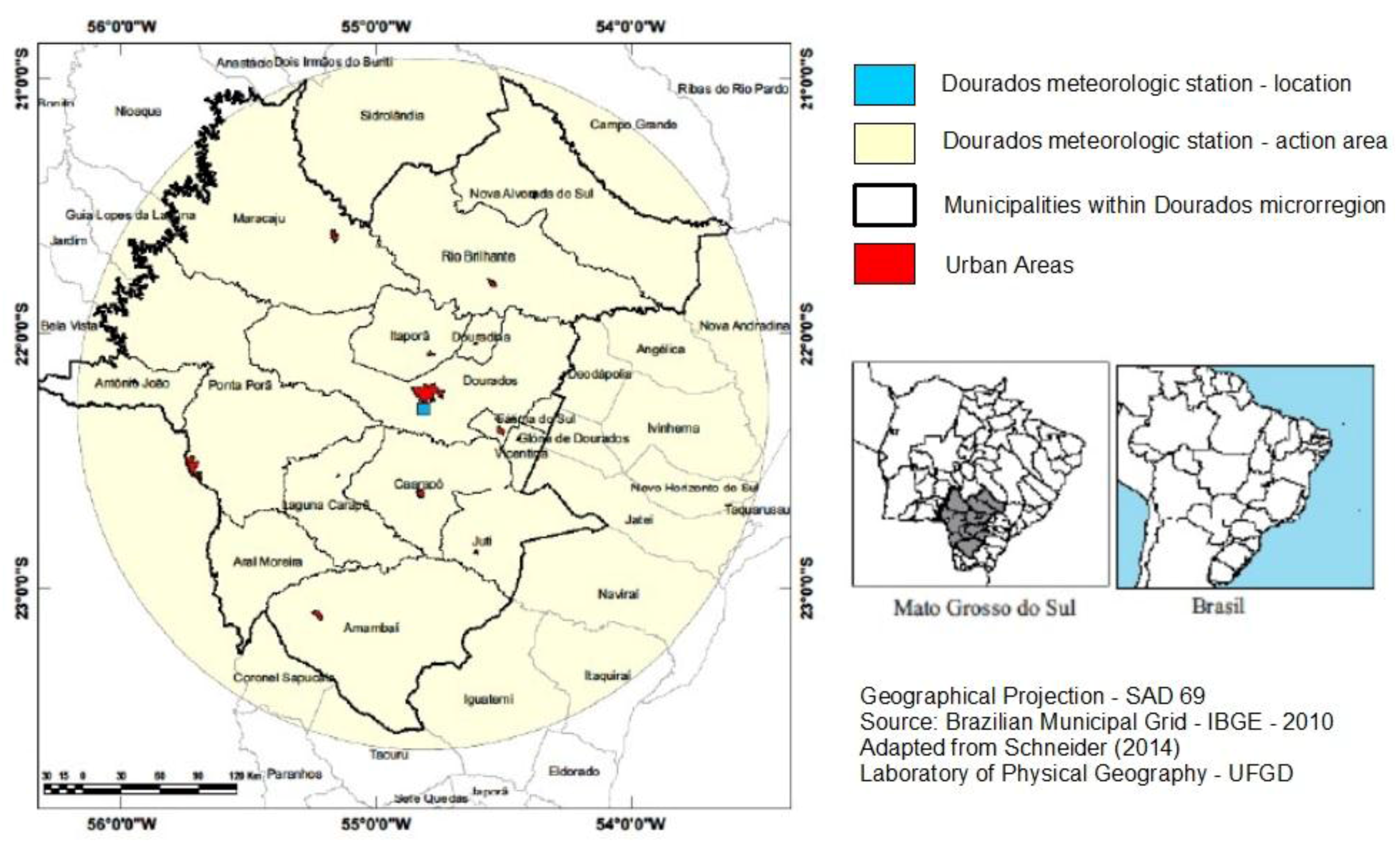
Figure 3.
Pluviometric anual values of the state of Mato Grosso do Sul. Adapted from Plano Estadual de Recursos Hídricos—Mato Grosso do Sul PERH-MS (2010) [27].
Figure 3.
Pluviometric anual values of the state of Mato Grosso do Sul. Adapted from Plano Estadual de Recursos Hídricos—Mato Grosso do Sul PERH-MS (2010) [27].
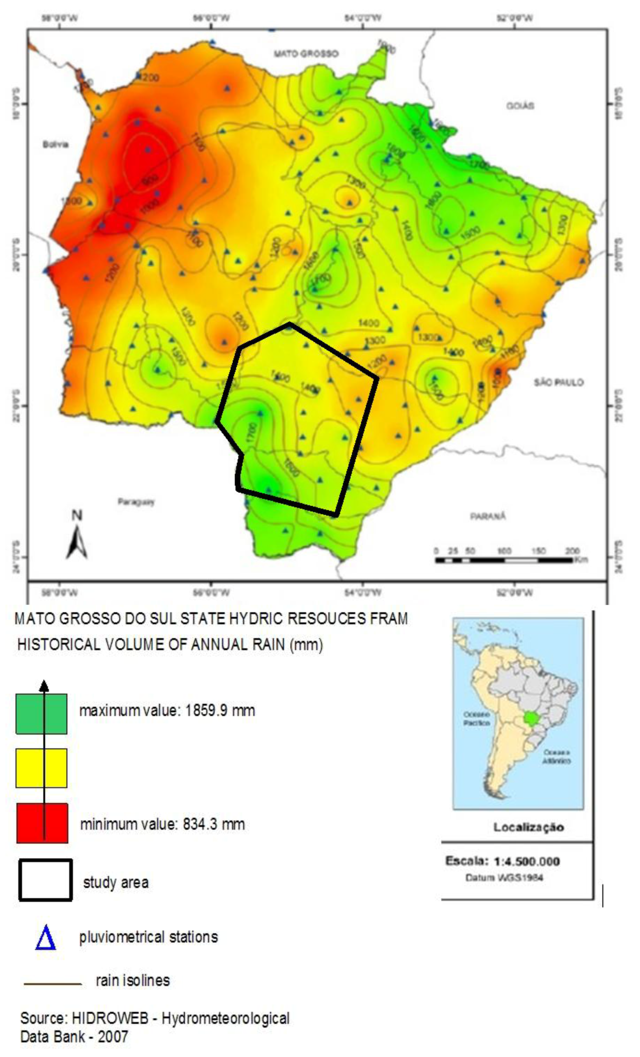
Figure 4.
Land use modification process of the Dourados region in 1985. Adapted from Schneider (2014) [5].
Figure 4.
Land use modification process of the Dourados region in 1985. Adapted from Schneider (2014) [5].
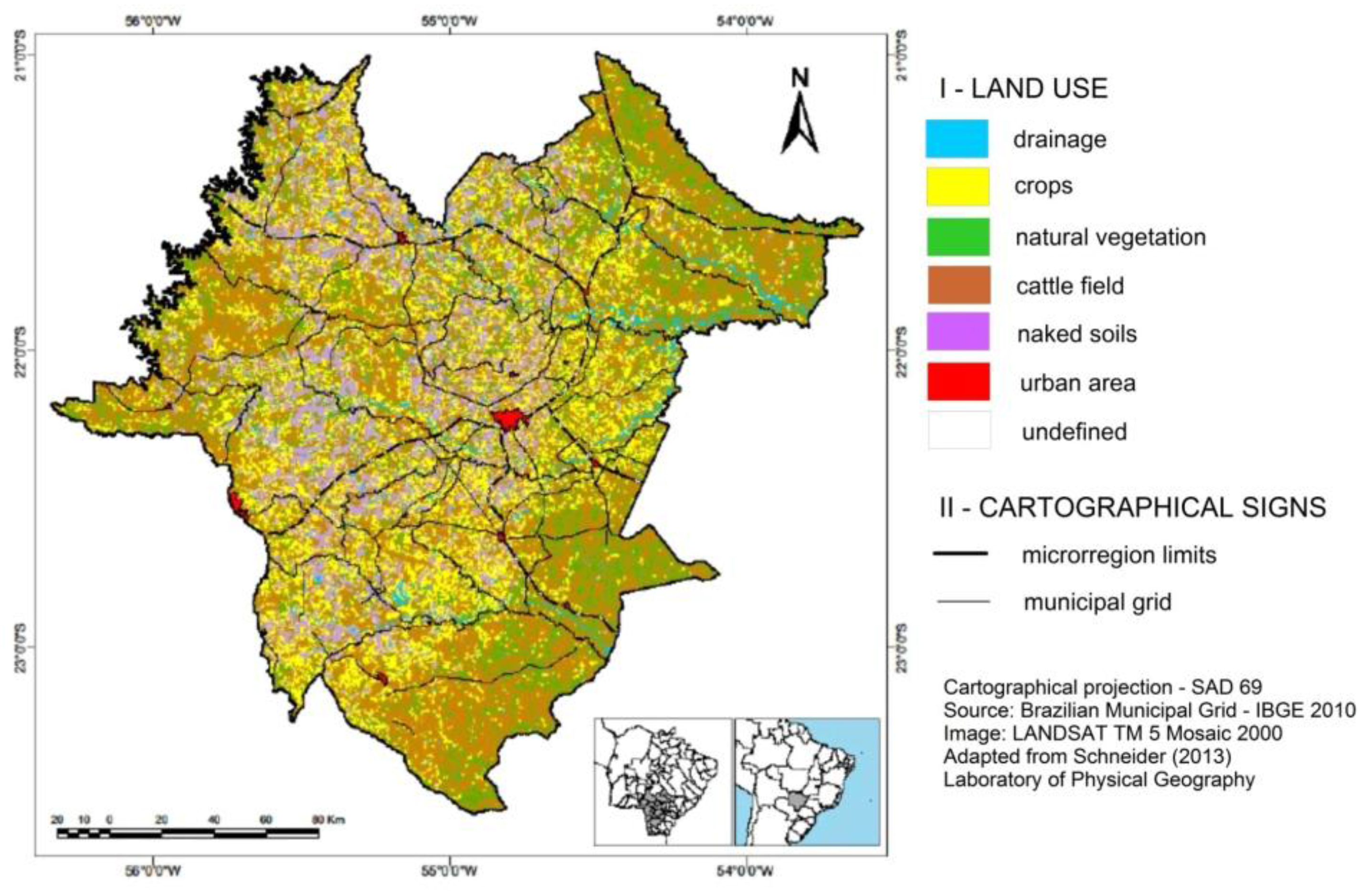
Figure 5.
Land use modification process of the Dourados region in 2000. Adapted from Schneider (2014) [5].
Figure 5.
Land use modification process of the Dourados region in 2000. Adapted from Schneider (2014) [5].
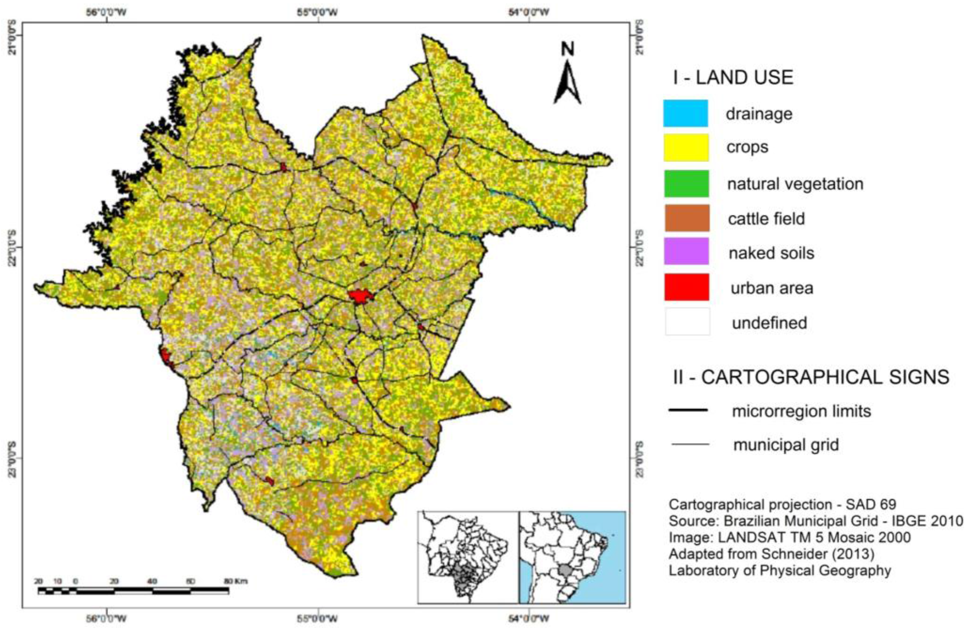
Figure 6.
Land use modification process of the Dourados region in 2010. Adapted from Schneider (2014) [5].
Figure 6.
Land use modification process of the Dourados region in 2010. Adapted from Schneider (2014) [5].

Figure 7.
Seasonal pluviometrical volume of the Amambai watershed (southern sector of the Dourados region). Source: Berezuk apud Silva et al. (2014) [2].
Figure 7.
Seasonal pluviometrical volume of the Amambai watershed (southern sector of the Dourados region). Source: Berezuk apud Silva et al. (2014) [2].


Table 1.
References used that aim to explain some possible climatic changes inside the study area (Dourados region).
Table 1.
References used that aim to explain some possible climatic changes inside the study area (Dourados region).
| Materials Used | Method | |
|---|---|---|
| BEREZUK, A. G. In: SILVA, C. A.; FIALHO, E. S.; STEINKE, E. T. (2014) | Pluviometrical data (from ANA); Microsoft Office Excel 2010. | Studies with trend lines graphics and classic statistics techniques in climatology. |
| BEREZUK, A. G.; GARCIA (2011) (Neighbour region) | ||
| SCHNEIDER, H (2014) | Pluviometrical Data (from EMBRAPA), Corel Draw, LANDSAT Image TM5. | Box plot method and data that were collected in regional newspapers and magazines |
| SOUZA, E. C. A. M. (2013) | Pluviometrical data (from ANA, EMBRAPA, INMET); Microsoft Excel 2007. | Studies using pluviograms and trend line graphics. |
| SOUZA, E. C. A. M.; SILVA, C. A.; BEREZUK, A. G (2012) | ||
| PINTO JÚNIOR, S. C. (2014) | ARCGis 9; Spring 5.0.6; Microsoft Excel 2007; Pluviometrical Data (from EMBRAPA, INMET); CANASAT/INPE images; INPE spatial images; IBGE data; DATASUS data. | Analysis of regional thermal images and data collected from Brazilian public agencies (DATASUS) |
| PINTO JÚNIOR, S. C.; SILVA, C. A.; BEREZUK, A. G. (2014) | ||
| SANTOS, V. A. (2014) | Handheld laser particle counter; thermo-higrometer; GPS; Microsoft Excel 2010; Google Earth. | Climate studies using measuring equipment to quantify air particulates in urban areas |
ANA means Brazilian Water Agency [20]; EMBRAPA means Brazilian Agricultural Research Corporation [21]; INMET means Brazilian Institute of Meteorology [22]; CANASAT means Sugarcane Crop Monitoring in Brazil [23]; INPE means National Institute for Space Research or Brazilian Institute for Space Research [24]; IBGE means Brazilian Institute of Geography and Statistics [11]; DATASUS means the data processing department of the Brazilian Health System [25].
Table 2.
Land Use Exploration—Dourados Region (1970–2010).
| Municipalities | Crop Area (ha.-hectare) | |||||||
| 1970 | 1975 | 1980 | 1985 | 1995 | 2005 | 2010 |  | |
| Amambai | 11,492 | 33,394 | 43,015 | 41,986 | 12,594 | 28,864 | 38,334 | |
| Antonio João | 1972 | 8554 | 6013 | 6107 | 10,240 | 12,778 | 14,018 | |
| Aral Moreira | - | _ | 47,262 | 47,961 | 47,465 | 50,154 | 50,552 | |
| Caarapó | 18,854 | 17,796 | 26,119 | 25,080 | 31,473 | 36,748 | 40,681 | |
| Douradina | - | - | - | - | 12,362 | 13,603 | 15,420 | |
| Dourados | 44,271 | 122,751 | 150,617 | 150,468 | 97,626 | 124,915 | 130,090 | |
| Fátima do Sul | 28,524 | 21,189 | 23,369 | 22,595 | 11,602 | 14,848 | 16,869 | |
| Itaporã | 15,734 | 24,664 | 35,873 | 35,388 | 38,697 | 37,239 | 40,153 | |
| Juti | - | - | - | - | 1474 | - | 2698 | |
| Laguna Caarapã | - | - | - | - | 25,859 | 29,110 | 35,652 | |
| Maracaju | 13,258 | 98,685 | 44,422 | 84,472 | 106,772 | 157,063 | 185,855 | |
| Nova Alvorada do Sul | - | - | - | - | 16,438 | 20,203 | 21,860 | |
| Ponta Porã | 19,418 | 151,514 | 176,223 | 176,381 | 107,845 | 117,446 | 125,429 | |
| Rio Brilhante | 5293 | - | 102,510 | 102,674 | 85,049 | 89,714 | 101,110 | |
| Vicentina | - | 79,068 | - | - | 5139 | 5001 | 4508 | |
| Dourados Region | 151,416 | 513,557 | 695,414 | 693,112 | 610,635 | 737,686 | 823,229 | |
| Municipalities | Cattle Field Area (ha.-hectare) | |||||||
| 1970 | 1975 | 1980 | 1985 | 1995 | 2005 | 2010 |  | |
| Amambai | 403,066 | 467,391 | 642,919 | 490,917 | 314,574 | 209,804 | 201,154 | |
| Antonio João | 77,469 | 81,310 | 85,393 | 89,399 | 82,607 | 72,373 | 72,310 | |
| Aral Moreira | - | - | 71,881 | 78,392 | 69,223 | 64,212 | 57,792 | |
| Caarapó | 161,695 | 233,383 | 264,350 | 245,662 | 135,530 | 130,414 | 125,148 | |
| Douradina | - | - | - | 10,893 | 10,456 | 7219 | 7219 | |
| Dourados | 346,004 | 275,075 | 173,230 | 200,449 | 207,085 | 196,224 | 178,156 | |
| Fátima do Sul | 18,905 | 26,251 | 23,655 | 24,330 | 9703 | 6226 | 5092 | |
| Itaporã | 76,619 | 57,738 | 53,493 | 49,112 | 59,636 | 49,204 | 44,532 | |
| Juti | - | - | - | - | 89,595 | 83,734 | 80,926 | |
| Laguna Caarapã | - | - | - | - | 90,625 | 86,276 | 81,965 | |
| Maracaju | 343,895 | 281,957 | 277,492 | 258,197 | 269,750 | 232,390 | 198,707 | |
| Nova Alvorada do Sul | - | - | - | - | 220,037 | 207,746 | 199,845 | |
| Ponta Porã | 506,353 | 472,710 | 391,020 | 385,423 | 283,355 | 221,304 | 191,493 | |
| Rio Brilhante | 469,775 | 414,681 | 423,966 | 398,449 | 197,326 | 185,705 | 167,696 | |
| Vicentina | - | - | - | - | 21,917 | 20,728 | 18,855 | |
| Dourados Region | 2,403,781 | 2,310,476 | 2,407,399 | 2,231,193 | 2,061,419 | 1,773,559 | 1,630,890 | |
Adapted from Schneider (2013), p. 59 [5].
© 2017 by the authors. Licensee MDPI, Basel, Switzerland. This article is an open access article distributed under the terms and conditions of the Creative Commons Attribution (CC BY) license (http://creativecommons.org/licenses/by/4.0/).
Share and Cite
MDPI and ACS Style
Berezuk, A.G.; Silva, C.A.d.; Lamoso, L.P.; Schneider, H. Climate and Production: The Case of the Administrative Region of Grande Dourados, Mato Grosso do Sul, Brazil. Climate 2017, 5, 49. https://doi.org/10.3390/cli5030049
AMA Style
Berezuk AG, Silva CAd, Lamoso LP, Schneider H. Climate and Production: The Case of the Administrative Region of Grande Dourados, Mato Grosso do Sul, Brazil. Climate. 2017; 5(3):49. https://doi.org/10.3390/cli5030049
Chicago/Turabian StyleBerezuk, André Geraldo, Charlei Aparecido da Silva, Lisandra Pereira Lamoso, and Heverton Schneider. 2017. "Climate and Production: The Case of the Administrative Region of Grande Dourados, Mato Grosso do Sul, Brazil" Climate 5, no. 3: 49. https://doi.org/10.3390/cli5030049
Note that from the first issue of 2016, this journal uses article numbers instead of page numbers. See further details here.