1. Introduction
In cities of developing countries, particularly in African, Asian and Latin American continents, there have been growing concerns regarding the state of public transportation systems. One of the main concerns has been a lack of well-integrated, reliable and efficient public transport systems. This is particularly so in urban centers due to rapid growth of the urban population coinciding with the end of colonialism and giving rise to large scale economic, spatial and structural transformations of urban landscapes. The consciousness of the need for well-functioning innovative public transport systems in all spheres of governments and private sector institutions has thus prompted precipitate action in the past decades to invest in innovative transport systems.
On the other hand, mobility in the urban context is continuously adapting and transforming to quotidian challenges, as seen with the global shift towards smart city planning. This shift which encourages communities to utilize multi-mobility modes and public transport in their everyday commute has led to a lessening of the negative impacts of private-car–dependence in the developed cities (such as congestion which has become a norm in major roads in urban areas) [
1]. Typically, sustainable urban mobility describes movement patterns or city transport networks which are utilizing active travel modes, energy efficient renewable forms of energy or shared vehicles wherever possible, resulting in a low carbon output per commuter journey [
2]. Integrated multimodal networked public transport has emerged as a mobility paradigm, utilizing transfer potential to provide maximal service for a reasonable and efficient operating budget, providing a genuinely feasible alternative to automobile travel for many trips within urban areas [
3].
However, just like any other rapid growing metropolitan municipality in developing and emerging economies, Johannesburg has not been released from continuous public transport challenges. In the past decade, Johannesburg has therefore actively participated in the development of the Gautrain first fast train system within the Gauteng province in conjunction with two other metropolitan cities (City of Tshwane and Ekurhuleni Metropolitan Municipality). To support this innovative train system, Johannesburg also invested in and developed the Rea Vaya rapid Bus Transit System (BRT). However, the state of connectedness between the rail and road route networks within the city has not been well documented. The aim of the current study was therefore to delineate the extent of network integration between the Gautrain and Rea Vaya within the Johannesburg urban public transport system. The cognizant planning efforts on improving the operational relationship among the two modes of urban public transport are also highlighted to achieve well-functioning, convenient and integrated public transport commuting.
2. Conceptual Framework: Integration in Urban Public Transport Provision
Literature on commuters’ need for integrated urban public transport has been well documented [
4,
5,
6,
7], as there has been a global growth in research on how to achieve integrated public transport operations in cities around the world. Some researchers suggest that “the term transport integration denominates concepts such as technical, economic, organizational, information and policy-based concepts; and solutions that pledge the continuity of travels from door to door” [
8]. Nevertheless, transport integration is mainly focused on connecting various transportation modes operating in certain transport systems, providing solutions to facilitate commuters between the modes, and assuring an efficient, smooth flow of commuters from their origins to their destinations [
9].
Integration of an urban public transportation is defined as an organizational process by which components of the commuter public transportation system (Network and infrastructure, information and marketing components, fares and ticketing systems) and a variety of carriers [
10], who serve different transportation modes interact more closely and efficiently. This generates an overall improvement in service quality level and enhanced performance of the combined public and individual transportation. In particular, the implementation of various transport integration solutions may result in benefits such as reduction of travel times, transportation costs, environmental pollution and traffic congestion [
8]. Transport integrating solutions may additionally improve the urban public transport system accessibility and overall competitiveness as well as assuring better utilization of different transportation means and infrastructure.
Moreover, integration of urban public transportation is mostly determined by the pattern of land use, the nature of the transportation systems, and the characteristics of the commuters [
4]. Travel cost, time, distance, and the choice of travel mode are also important factors. The closer the origin and destination to the main transportation system the higher the level of connectivity [
10]. Furthermore, a wider variety of modes for travelling between a given origin and a particular destination will promote greater connectivity. In addition, less time and money spent in travel enables greater connectivity through enabling more places to be reached within a certain budget [
11]. For the concept of connectivity to be useful for evaluation of the need for and effectiveness of transportation and land use planning policies, it needs to be translated into measures of connectivity. These determine the degree of connectivity within a transportation network.
There are different types and forms of transport integration in the urban areas. These include integration of different modes of public transportation and integration of public and individual transportation. They incorporate integration of transportation policy with other policies concerning spatial planning and city management; spatial integration based on the application of efficient land use strategies (such as multimodal terminals and interchange platforms and shared lanes for means of public transportation) [
12]. They further comprise of infrastructural integration based on development of various technical solutions in transportation infrastructure (for instance passageways connecting public transportation stops, overpasses, underpasses, shared stops for public transportation); organizational integration (for instance metropolitan tickets various transportation modes and coordinated timetables); economic integration focused on introduction of various measures supporting sustainability and efficiency of the public transportation systems (for example integrated tariffs). Informational integration (passengers’ information systems; web pages; electronic travel planners [
13].
3. Study Area
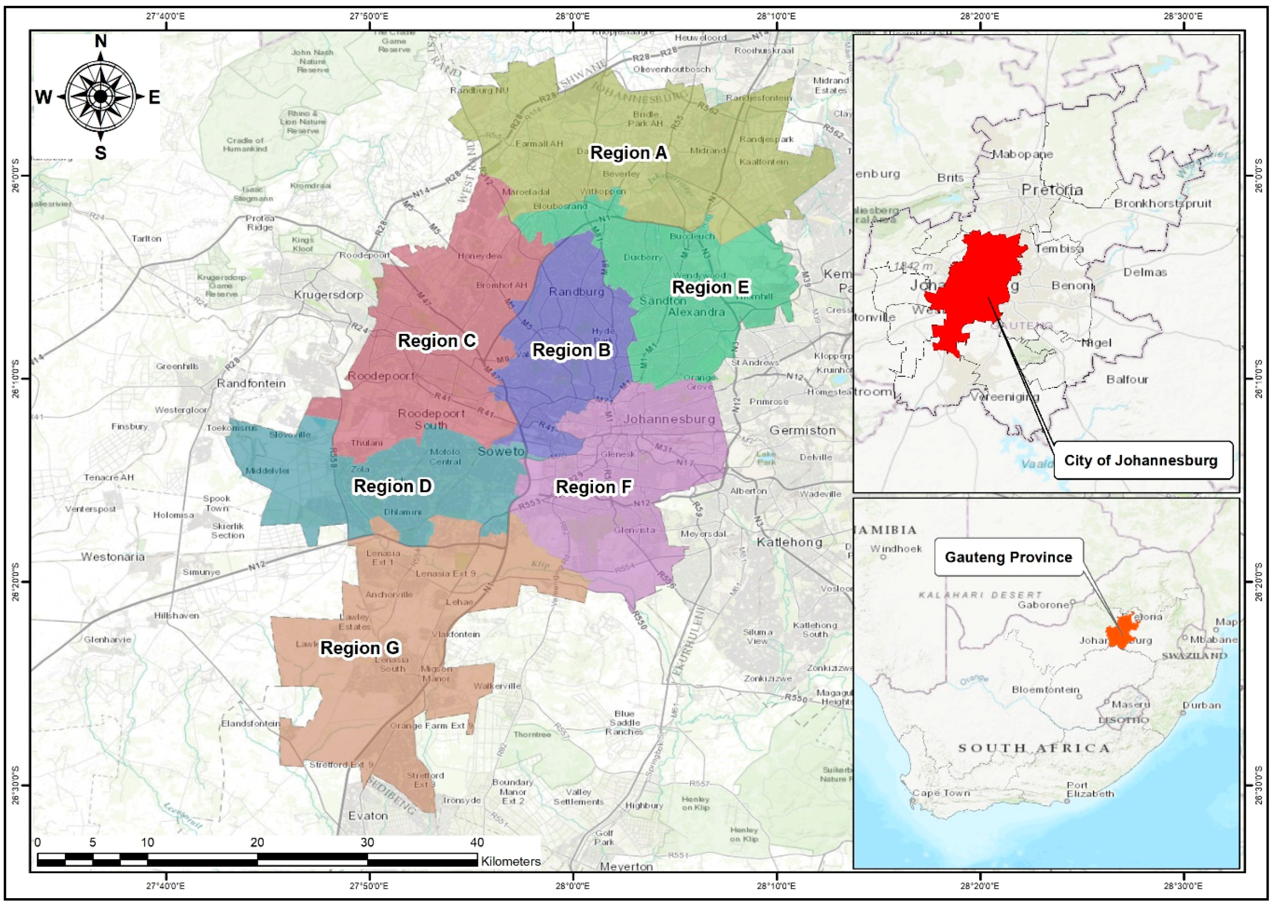
Johannesburg Metropolitan City is a well-developed economic hub and the fastest growing city in terms of the population, economy and development in South Africa. The city is located in the Gauteng Province, and covers an area of approximately 1645 km
2 [
14]. It is divided into seven regions, namely Region A, B, C, D, E, F and G (illustrated in
Figure 1). Johannesburg is over populated, but is the economic hub of South Africa. The Johannesburg metropolitan City, and its neighboring metropolitan cities (City of Tshwane and City of Ekurhuleni) share the most innovative transportation mode, the Gautrain in Gauteng, connecting these three functional cities into one capital and economic region (see
Figure 1). Thus perpetuated by demand, routes of urban public transport systems, commuters’ movement patterns and accessibility have become central issues within the Johannesburg Metropolitan City.
Johannesburg has been defined as a world class African city. This definition entails that the city will strive to become a smarter city; however, what is it to be ‘smart’. Does this only involve decision-making or the use of advanced technology? Scholars have over the years articled that at the core of the development of smart cities is the need for developments which improve the quality of life of the citizens [
15]. Currently, Johannesburg is promoting transit-oriented developments (TODs) in previously marginalized areas by focusing on development of economic and business nodes located within Regions F, B and E (
Figure 1). Regions G and D are characterized by medium to low income residential spaces. Regions A and C are characterized by medium to high income residential spaces with some commercial activities. However, the existing urban public transportation network is spatially segregated, and there is little to no clear collaboration between the various public transit providers (namely the Rea Vaya; Gautrain/bus; Metro Bus/rail; Meter-taxis; Mini-bus taxi; and Uber), as they are developed and operated separately. Hence a knowledge gap exists of how to connect commuters and these places of economic and business activities.
Urban public transport is at the heart of Johannesburg’s development agenda. There have been efforts made to create a Transit Oriented Development Urban renewal as a way of building a corridor of freedom [
16]. The Johannesburg Metropolitan Municipality caters for both non-motorized and motorized urban public transportation. These include Gautrain, Rea Vaya BRT, Metrobus, Metrorail, Putco, Minibus Taxis, Uber and dedicated lanes for private bicycle cyclists. Public transportation in the Johannesburg Metropolitan City is used by youth to commute to school, to get to service hubs and recreational areas, while adults use these to commute to work and recreational areas. Old aged citizens use them to commute for leisure and to get to basic services. However, for the purpose of this study two urban public transport modes are explored on the state of routes connectivity.
The Rea Vaya BRT and Gautrain are located in the City of Johannesburg within the Gauteng province, Republic of South Africa. The Rea Vaya operates only under the jurisdiction of Johannesburg in the southern region. The Gautrain operates within the three metropolitan cities in Gauteng province, including the City of Tshwane, City of Johannesburg and City of Ekurhuleni in the East Rand of Gauteng Province. The three metros, as mentioned earlier, form the region which is the economic hub of the Republic of South Africa, and are the only cities in the entire country that have a rapid transit train. These two public transport modes started operating during the 2010 FIFA World Cup which was hosted by South Africa. They also operate along mixed land used as well as in major economic, institutional and social nodes, such as the Johannesburg Park Station, OR Tambo International Airport, FNB Stadium, Emirates Airline Park Stadium and Sandton and so on.
4. Materials and Methods
The study adopted a phenomenological case study survey design which applied a mixed-method approach to gather spatial, qualitative and quantitative data. The study examined the applicability of location based services to define the state of public transport routes connectivity and movement patterns of commuters within the Johannesburg Metropolitan City. The exploratory approach was used to formulate the research problem for precise investigation, while the descriptive approach was used to gather complete and accurate information. Key informant interviews were held with a variety of key informant personnel from the Johannesburg Roads Agency (JRA), Gautrain Management Agency (GMA) and Gauteng Department of Roads and Transport. This gave complete and accurate information on the Gautrain and Rea Vaya routes connectivity in Johannesburg Metropolitan City; and the attained information was analyzed using content analysis.
The study period was from January to August 2017, and the spatial, qualitative and quantitative analyses were triangulated to yield viable results. Crowd sourced data from social media posts (Twitter and Facebook) were collected and analyzed through Echo-Echo. A total of 42630 Rea-Vaya and Gautrain geo-location social media datasets were received in Excel format from Echo-Echo. Nevertheless, Echo-Echo is an independent private company that collects and analyzes social media information from a variety of web 2.0 platforms. Using sentiment analysis and semantics analysis, Echo-Echo untangles the big social media data to derive meaning from these large quantities of text [
6]. The results are captured live and analyzed through Echo-Echo. In this study, co-ordinates of geographic locations of the social media posts were converted into shapefiles and spatially interpreted using the Geographic Information Application (ArcGIS 10.3). The aim of this conversion of geographic social media co-ordinates into shapefiles was to create maps through the kriging interpolation method. Maps were also used to visualize high commuter concentration zones and low commuter concentration zones and to help to track the movement patterns of commuters using Rea Vaya and the Gautrain.
Table 1 below illustrates the summary of information gathered during the study.
5. Results of the Study: Modes of Public Transport and Their Routes’ Integratedness within the Johannesburg Metropolitan City
This section of the manuscript presents the research results related to the extent of the networks integration among the Gautrain and Rea Vaya within the City of Johannesburg urban public transport system. The section further connects the study results with the aim and objectives of the study and affirms the study results to come up with conclusions and recommendations. A starting point for this section was that the Johannesburg Urban Public Transport has been appointed in terms of a Service Delivery Agreement by the City of Johannesburg to provide integrated, reliable and efficient urban public transportation to the residents of the city, including the previously marginalized areas of the city. Therefore, the Johannesburg public transport system functions in the purpose of the City of Johannesburg legislative mandate regarding urban public transport and the systems. It is guided by the strategic direction of the City, as derived from the Province Growth Development Strategy and Integrated Development Plan. The Corridor of Freedom and Integrated Transport Plan are amongst some key strategic objectives of the Johannesburg public transport system, where Gautrain and Rea Vaya play the main roles in the provision of public transportation.
5.1. Moving with Gautrain
The Gautrain is one of several strategically integrated Gauteng Provincial Government projects designed to meet future transport demands anticipated because of economic and population growth [
6]. It is also referred to as a mega-engineering project. It is a state-of-the-art rapid rail connection between the City of Johannesburg (Africa’s business capital), the City of Tshwane, and the City of Ekurhuleni [
13]. The Gautrain has been identified as the backbone for public transit provision in the Gauteng province. The Gauteng City Region (GCR) can best be described as a cohesive cluster of cities, towns and urban nodes. These collectively make up the economic hub of South Africa, generating more than 36% of the country’s Gross Domestic Product (GDP), whilst covering less than 2% of the South Africa’s total surface area.
Figure 2 illustrates the Gautrain routes and stations map.
In terms of routes networks, the Gautrain alone operates in three metropolitan cities in Gauteng province namely the City of Johannesburg, City of Pretoria and Ekurhuleni Metropolitan municipality. It has only 10 functional train stations, namely Park, Rosebank, Sandton, Marlboro, Midrand, Centurion, Pretoria, Hatfield, OR Tambo and Rhodesfield. However, the Gautrain within jurisdiction of City of Johannesburg operates in the up market areas such as Rosebank, Sandton, Randburg and Fourways. Gautrain does not operate in the southern areas of Johannesburg, and conversely there are potential clients and a need for expansion and integration with Rea Vaya that is currently operating in that area (See
Figure 2).
5.2. Relying on Rea Vaya
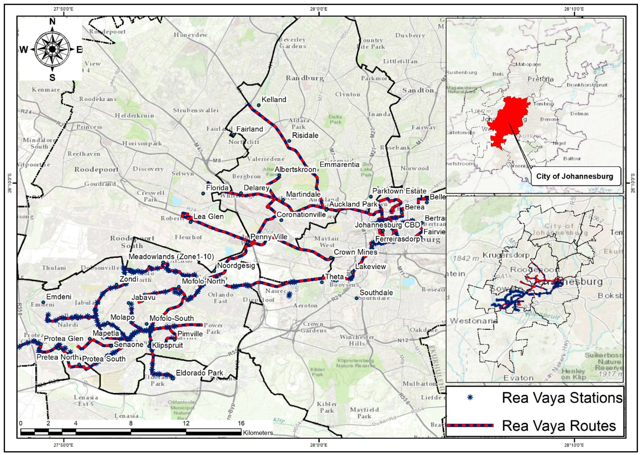
The Rea Vaya Bus Rapid Transit (BRT) is a fairly new bus system in Johannesburg. Its launch in 2009 was met with much uncertainty, but also with positivity, as a new public transport initiative for the city. The system can be found in many different areas across the greater urban fabric of Johannesburg, connecting the south to the north and the east to the west. It covers a route of 325 km to date and continues to expand [
4]. The system is made up of trunk routes that keep to designated lanes and are connected by stations along the route. The T1 route runs from Thokoza Park in Rockville, Soweto and ends in Ellis Park. There are more than 15 bus stations across this route, which facilitate access to the buses. The main trunk routes are supported by complimentary and feeder routes which navigate other parts of the city. These feeder buses use the main routes of the road network like other vehicles and public transport systems.
Figure 3 illustrates the Rea Vaya Bus Stations and Bus Routes.
In terms of the routes network, Rea Vaya operates in Regions B, D and F within the Johannesburg Metropolitan City. It operates in different phases and has systematic hierarchical routes which connect micro city hubs in the metropolitan city of Johannesburg. It has completed the construction of Phases 1A and 1B and is currently developing Phase 1C. Rea Vaya’s Phase 1A has a trunk route operating between Ellis Park in Doornfontein and Thokoza Park in Soweto, linking with several feeder routes to Soweto. Feeder buses run from Protea Glen to Thokoza Park and from Eldorado Park to Lakeview. The route covers 325 km of special lanes and intersections, while feeder and complementary buses carry passengers to the trunk route stations.
The inner city circular route travels around the Central Business District from Hillbrow and Braamfontein to Ellis Park in the east and Chancellor House on the western edge of the city. The Phase 1B has routes which operate through Cresta, Windsor West, Parktown and Yeoville. In addition, routes operating to and from the University of Johannesburg Soweto Campus are being added. The route starts in Noordgesig in Soweto and travels through Pennyville, New Canada, Highgate, Auckland Park and Braamfontein to Parktown, Metro center and Rissik Street in the Johannesburg Central Business District.
The route has made it possible for commuters to easily reach key public healthcare centers such as the Rahima Moosa, Helen Joseph and Charlotte Maxeke hospitals. It has also enabled easy reach of educational institutions such as the University of Johannesburg, Wits University, Milpark College, Parktown Boy’s High School and Barnato Park High School. Feeders run to and from Leaglen, Stormhill, Florida, Cresta, Yeoville and Parktown. There are also additional feeders in Soweto from Pimville and Mapetle. These routes are now linked to the Metro Centre Rea Vaya loop which travels to the inner city through Braamfontein.
Rea Vaya’s current focus is the development of Phase 1C following the completion of Phase 1B. Phase 1C will run from: Parktown to Alexandra; then Alexandra to Sandton, with complementary services between the CBD and Ivory Park; and from the CBD to Sunninghill on Oxford and Rivonia Roads. Future plans also include extending the Phase 1C route from Sandton to Randburg by 2018, and possibly extending the Phase to the trunk route from Soweto Highway to Dobsonville, enabling feeders to services areas such as Braamfisherville. Construction for the routes and stations has already started in the Sandton area. The Rea Vaya trunk routes from the CBD to Sunninghill through Oxford Road and Ivory Park to Sunninghill will be prioritized after 2018. The three interchanges will be at Sandton, Alexandra and Westgate, where a number of station modules will be clustered, and there will be integration with other modes of transport, including walking and cycling.
With an intention to be one of the most sustainable forms of public transport in the city, the Rea Vaya is noted as cost effective, safe and relatively reliable. It is considered as an inherent component of the city’s future urban form, as it is one of the main elements of the corridors of freedom initiative. Finally, the Rea-Vaya is referred to as one of the most determined initiatives by the city, being spear headed by a woman and having a completion goal of three years from ground breaking to implementation and operation [
5].
5.3. Analysis of Gautrain and Rea Vaya Networks Integration
The findings of this study indicate that there are limited areas where the routes networks between the two public transport systems are connected (see
Figure 4). Currently, the Gautrain operates in the upper market areas of Johannesburg, such as Rosebank, Midrand, Sandton, Randburg and Fourways. Whilst the Rea Vaya does not have existing networks in these locations. Rea Vaya’s Phase 1A has a trunk route operating between Ellis Park in Doornfontein and Thokoza Park in Soweto, linking with several feeder routes from Soweto. Feeder buses run from Protea Glen to Thokoza Park and from Eldorado Park to Lakeview. The Rea Vaya has proven successful in improving accessibility to economic opportunities for locations which were once spatially segregated in Johannesburg. A total of 70% of the social media posts reflect positive views regarding route and timetables of the Rea Vaya. This can be seen through the recent infrastructural upgrades which have improved the network flow from Soweto to the inner CBD in Braamfontein.
The existing urban public transport network is spatially segregated, and there is little to no clear collaboration between the Gautrain and Rea Vaya. They were developed and currently operate separately (initially the two modes were developed in preparation for the 2010 FIFA World Cup; however over the years there have been advances with different goals, since the Gautrain seeks to service the high to medium income group and the Rea Vaya the medium to low income group). This presents a knowledge gap of how to connect commuters to places of economic and business activities. However, from the works of modern day scholars [
10,
13,
15], the network integration of the public transport systems will lead to improved service delivery, inter-connectivity of places of economic activity and improve quality of life. Therefore, for the City of Johannesburg to promote smart mobility there is a need for the development of planning support systems which will guide the growth and integration of the existing and future public transport systems.
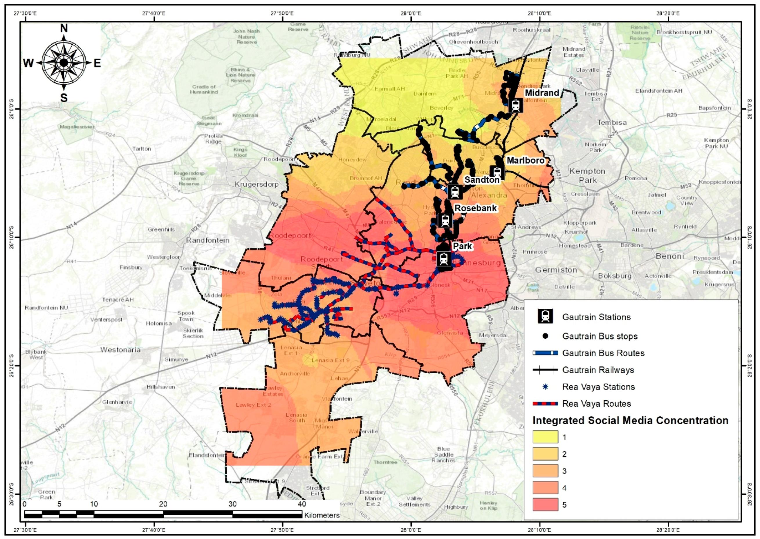
Notably, as illustrated in
Figure 4, there are three possible connections: Integration points A, B, and C. Integration Point A is located near Marshalltown and Ferreirasdorp, and will function as a center for Administration hub, high density residential areas and commercial center of the inner city. At Integration Point B, the Johannesburg Park Station which is situated at the CBD of the city functions as a vibrant intermodal transport node. It is a major public transport interchange, where public transport networks integrate, and commuters come from all over Johannesburg, South Africa, Africa, or transfer from trains and buses to minibuses and more. The Gautrain and Rea Vaya services at Park station provide inter-city transport as well as intra-city and regional transport services. Given that Johannesburg Park Station is a prominent transport terminal in Johannesburg, Gauteng, South Africa, and Africa, distribution terminals in the form of bus stations, rail stations and taxi ranks are located in close proximity to the Park Station precinct. Integration point C, located in Parktown provides an interconnection of Public transportation for Educational and health institutes such as the University of Witwatersrand and Parktown Hospitals. The Gautrain Park Station, bus routes as well as the Rea Vaya Bus Rapid Transit routes should also be noted as essential feeders and distributor routes in the area.
5.4. Gautrain and Rea Vaya Social Media Commuter Concentration
The analysis and creation of maps to visualize the social media commuter concentration was prepared through the use of the kriging interpolation method. Based on the kriging interpolation of the locations of posts on social media, the majority of the commuters are located near the stations. This is due to the current stations being located in merging points of commuters such as the Park Station. This is located in the Johannesburg CBD and acts as the main interchange hub of Johannesburg and an entry point for most regional and local commuters. Also it is within close proximity to the MTN Taxi rank and Bree St Taxi Rank located only 10 min away. This hub has a high connectivity with public transportation levels. Notable areas, which are currently not serviced by the Gautrain and Rea Vaya, include Roodepoort; Randburg; Woodmead; Magaliessig; Honeydew; Fourways; Lenasia; Glenvista; and Lawley (see
Figure 5). Park Station has the highest integrated commuter concentration as shown in
Figure 5 and
Table 2.
Figure 5 above depicts that most of the Rea Vaya stations seem to be well located, as they are within the high commuter concentration zone based on the kriging interpolation of the locations of posts on social media.
Table 2 summarizes the analysis of the integrated social media commuter concentrations.
With the extremely high commuter concentration (see
Table 2), improving commuter transfer in the geolocation would be a virtuous starting point, since the infrastructure and commuter numbers are already pre-existing. While variations in income levels may be a factor to prevent inter-transfer between the two modes, commuters should be given an incentive for using both modes of transit in one trip. This could be a discount in commuter fares or points which can later be redeemed for a discount. This would build on the existing commuter concentration, and further attract other commuters to join the system. Moreover, as it would be cost effective for the two public transit providers to partner towards promoting multi-mobility within City of Johannesburg, rather than building separate infrastructures. The Gautrain would link commuters to economic and business hubs in the northern zones of Johannesburg, namely: Sandton, Rosebank, Marlboro and Midrand. The Rea Vaya would bring commuters to areas of economic and business nodes in the southern zones of the city.
5.5. Gautrain and Rea Vaya Commuters Movement within the City of Johannesburg
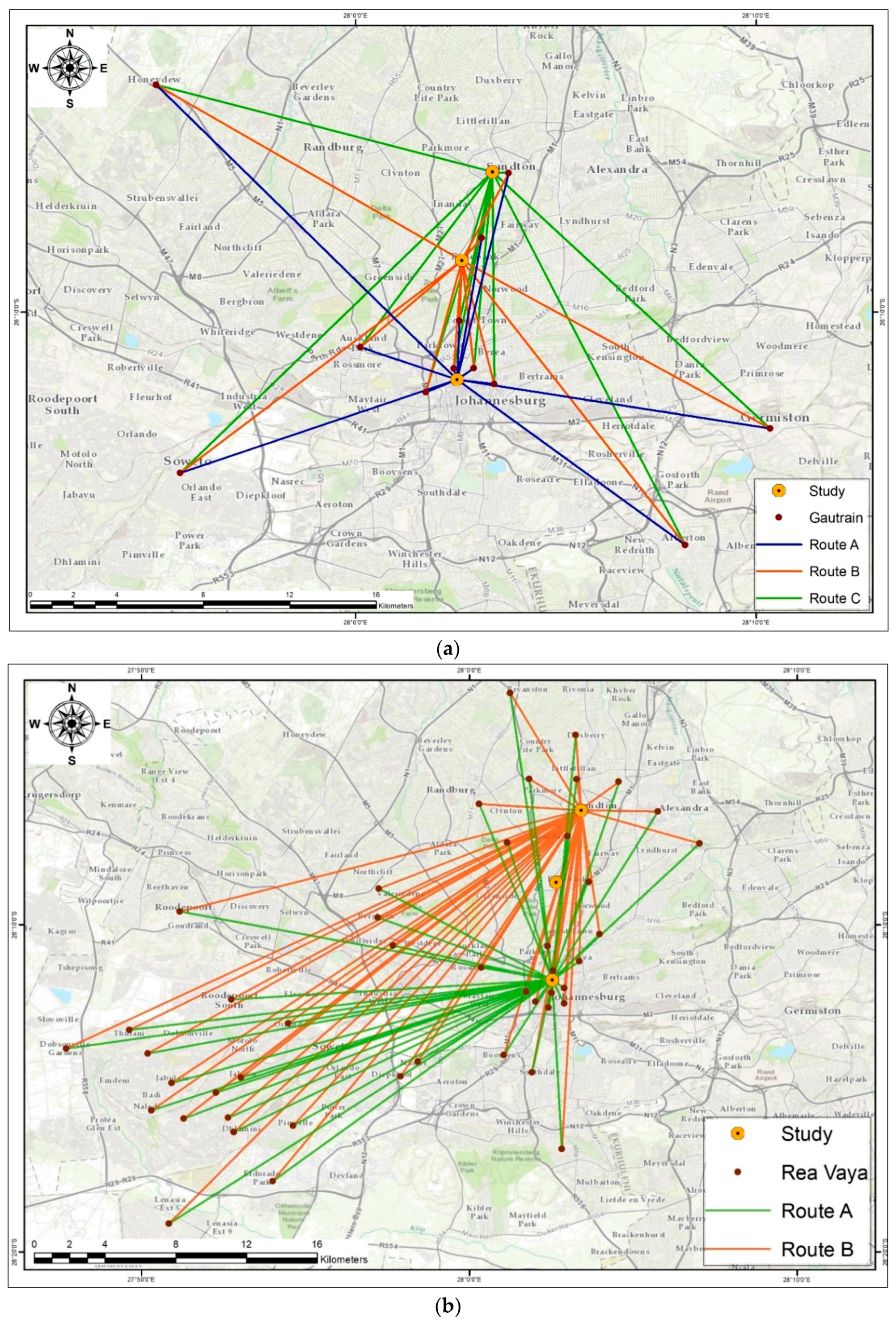
In this study, social media comments and their geographic location co-ordinates were used to track the movement patterns of commuters using Gautrain and Rea Vaya. Although their origins and destinations varied, their destinations were mainly economic hubs and places of economic activities such as Park station, Rosebank and Sandton. Their origins were mainly the residential areas of the city such as Soweto, Roodeport and Midrand. The location origins of the commuters’ social media posts and the comments on their destinations were used to digitize the maps (see
Figure 6a,b). Surprisingly, social media posts have been made in areas which are currently not serviced by either Gautrain or Rea Vaya such as areas of Region C and G; this shows that there is a need for expansion of public transportation in the catchment areas. The movement of commuters within the city changes with time [
9] as a result of developing transportation systems in addition to innovations within the Information and Communication Technologies Sector. While exploring the state of public transport networks integratedness within the City of Johannesburg in this endeavor, it is essential to understand the commuters’ movements within various areas of the city [
15].
It can be deduced from the results that from each location, commuters have two or three possible routes that they can take when travelling from their origins to destinations. For instance a commuter has two or three possible routes that he/she can take when travelling between Johannesburg Park Station and Sandton. These routes may be direct links from their origin to their destinations, or may be interconnected through other stations as alternative routes to reach their destinations of choice conveniently. The two modes of public transport in Johannesburg metropolitan city constantly need to track the movement of their commuters because of changes in their origin and destinations over time. Thus the idea of location based services is applicable in tracking commuter movement patterns through geo-locational patterns that display commuter concentration zones. Therefore, the idea is for the service provider to reach out to commuters in the form of expanding services or contracting emergency and temporary urban public transport in times when required most. This includes situations such as traffic congestion and tracking social media feeds using location based services analysis software such as Echo-Echo to manage their social media platforms effectively. This in turn will render real-time and effective service to many of its commuters and the public at large.
6. Discussion of Study Results
The context of public transport and transit-oriented development planning is continuously adapting and changing according to a number of challenges, as can be seen with the global shift towards smart city planning. The move towards encouraging societies to use transport multi-mobility modes in their daily commute, and to endorse the lessening in the negative impacts of automobile dependence is the anticipated shift in Johannesburg. Integrating and improving public transport modes is a desirable method for enhancing the use of multi-mobility and promoting transit ridership. However, the results of the study revealed that there are limited spaces where the route networks between the urban public transport systems are connected. However, the network integration of the public transport systems will lead to improved service delivery, inter-connectivity of places of economic activities and improved public transit ridership (Refer to
Figure 4). For example, the Gautrain services the northern areas of the City, whilst the Rea Vaya does not have existing networks in these areas. The Johannesburg BRT system and Rea Vaya service the southern spaces of the city, which were previously disadvantaged and spatially segregated during the Apartheid administration.
As made clear by the study findings, Rea Vaya has proven effectively in improving accessibility to economic opportunities for formerly marginalized locations such as Soweto. This is because the network flows from Soweto moving towards the Central Business District and the Northern parts of the City. In addition, the majority of the Rea Vaya stations are well located within the commuter concentration zones as revealed by the analysis co-ordinates of social media posts through the kriging exercise. The existing urban public transport network is spatially segregated, and there is little or no collaboration between the Gautrain and Rea Vaya, since they have been developed and operated separately. This illustrates a knowledge gap of how to connect commuters to places of economic and business activities. With this situation, improving commuter transfers in the geolocation would be a good starting point, as the infrastructure and commuter numbers are already pre-existing. Also, it would be cost effective for the two public transit providers to partner towards promoting multi-mobility within Johannesburg rather than building separate infrastructure. The Gautrain would link commuters to economic and business nodes in the northern parts of Johannesburg (namely Rosebank, Sandton, Marlboro and Midrand), and the Rea Vaya would link commuters to areas of economic and business nodes in the southern part of the city.
Notably, the kriging interpolation maps reveal areas which are currently not directly serviced by the Gautrain such as Soweto which has a high commuter concentration. With this in mind, commuters who reside in Soweto use Rea Vaya before they can access the Gautrain system. Accordingly, a partnership seems worthwhile for the Gautrain and Rea Vaya, since the Rea Vaya has an existing road network that flows from Soweto towards Johannesburg Park Station, and the Gautrain routes network flows from the Johannesburg Park station towards the northern areas of the city. In addition, the results also indicate that social media posts have been made in areas such as Roodeport and Lenasia in Regions C and G, which are currently not serviced by both the two public transport modes. This means that commuters who reside in these areas use another form of mobility before they can access either the Gautrain or Rea Vaya. Therefore, these are potential areas for routes network expansion of both Gautrain and Rea Vaya.
7. Conclusions
To conclude, mobility is continuously adapting and transforming to daily challenges, and should be perceived as a response to the global shift towards smart city planning. The shift is towards encouraging communities to utilizing multi-mobility modes and public transport in their everyday commutes. This will reduce the negative impacts of private-car-dependence in the urban contexts. This study delineated the extent of routes network integration of Gautrain and Rea Vaya within the Johannesburg urban public transport system. Crowd-source data is still a novel research activity, and this work shows the potential for these real-time data to be valuable in understanding system integration. Crowd sourced data is able to measure transit coverage area, visualize high and low commuter concentration zones, and also tracks the movement patterns of commuters. The study indicates that there are limited areas where the route networks between the public transport systems are connected. The large sections of the networks are fragmented. Actually, the existing transit networks are spatially segregated, and there is no partnership between the two modes of public transport, since they operate independently. The results can further be used as a reference to spot areas underserved by transport, and estimate the transit demand for planning purposes.
However, it is recommended that conscious efforts in planning and developing both rail and routes networks are integrated to promote efficiency of public transport systems. The network integration of the public transport systems will lead to improved service delivery, inter-connectivity of places of economic activity and improve quality of life. Therefore, for the City of Johannesburg to promote smart mobility, there is a need for development of planning support systems which will guide the growth and integration of the existing and future public transport systems. Typically, sustainable urban mobility describes movement patterns or city transport networks. These utilize active travel modes, energy efficient renewable forms of energy, or shared vehicles wherever possible, resulting in low carbon output per commuter journey. Integrated multimodal networked public transport has thus emerged as a mobility paradigm, utilizing transfer potential to provide maximal service for a reasonable and efficient operating budget, providing a genuinely feasible alternative to the automobile travel for many trips within urban areas.
Author Contributions
B.R. is currently a master’s candidate of the Department of Quality and Operations Management within the Faculty of Engineering and Built Environment, University of Johannesburg, South Africa. He holds a Bachelor’s degree in Town and Regional Planning from the University of Johannesburg. He is also registered as the Candidate Planner (Reg. No. C/8312/2016) with the South African Council for Planners (SACPLAN). B.R. wrote the manuscript, designed the study, collected and interpreted the data of the study. T.G. is currently an Associate Professor and Head of the Department of Town and Regional Planning within the Faculty of Engineering and the Built Environment in the University of Johannesburg (UJ). He Holds a PhD from Stellenbosch University, South Africa as well as Masters and Honours degrees from the University of Zimbabwe (UZ), Zimbabwe. He has previously worked in the Africa Institute of South Africa of the Human Sciences Research Council as a research specialist and Acting Manager for the sustainable development programme. T.G. has also worked as an international instructor in the urban management Masters programme within the Ethiopian Civil Service University College (ECSUC) in Addis Ababa in Ethiopia. Before, T.G. had worked as lecturer and Head of Department at the National University of Science and Technology (NUST) in Zimbabwe. He has attended and presented at several national and international conferences and has published widely on urban development and management. As the supervisor of B.R., T.G. contributed to all the processes of developing the study and executing it as well as writing and perfecting the manuscript. He also facilitated the financial support towards this study.
Funding
This study was funded by the National Research Foundation (NRF) of the South African government and the Department of Town and Regional Planning, University of Johannesburg.
Acknowledgments
The authors would want to acknowledge the support provided by Thembani Moyo during the analysis of the data; the National Research Foundation (NRF) of the South African government and the Department of Town and Regional Planning, University of Johannesburg for funding this study.
Conflicts of Interest
The authors declare no conflict of interest. The funding sponsor had no role in the design of the study; the collection, interpretation, or analysis of data; in the writing of the manuscript, and in the decision to publish the findings.
References
- Mishra, S.; Welch, T.F.; Jha, M.K. Performance indicators for public transit connectivity in multi-modal transportation networks. Transp. Res. Part A Policy Pract. 2012, 46, 1066–1085. [Google Scholar] [CrossRef]
- Fang, Z.; Shaw, S.L.; Tu, W.; Li, Q.; Li, Y. Spatiotemporal analysis of critical transportation links based on time geographic concepts: A case study of critical bridges in Wuhan, China. J. Transp. Geogr. 2012, 23, 44–59. [Google Scholar] [CrossRef]
- Dachs, W. Gautrain: A Case Study. Available online: www.gautrain.co.za (accessed on 18 December 2016).
- Mokoena, B.T.; Musakwa, W.; Moyo, T. Developing the Well-Located Land Index to Establish Smart Human Settlements for the Ekurhuleni Municipality, South Africa. In Proceedings of the International Computers in Urban Planning and Urban Management, Adelaide, Australia, 11–14 July 2017; Springer: Cham, Switzerland, 2017; pp. 95–112. [Google Scholar]
- Moswane, M.R.; Gumbo, T. Examining the applicability of Location Based Services to determine the movement patterns of commuters between Sandton and Park station in Johannesburg city. In Proceedings of the 22nd International Conference on Urban Planning, Regional Development and Information Society, REAL CORP 2017–PANTA RHEI–A World in Constant Motion, Vienna, Austria, 12–14 September 2017; pp. 195–207. [Google Scholar]
- Moyo, T.; Musakwa, W. Using crowdsourced data (Twitter & Facebook) to delineate the origin and destination of commuters of the Gautrain public transit system in South Africa. ISPRS Ann. Photogramm. Remote Sens. Spat. Inf. Sci. 2016, 3, 143. [Google Scholar]
- Musakwa, W.; Gumbo, T. Impact of Urban Policy on Public Transportation in Gauteng, South Africa: Smart or Dumb City Systems Is the Question. In Carbon Footprint and the Industrial Life Cycle; Springer: Cham, Switzerland, 2017; pp. 339–356. [Google Scholar]
- Di Pietro, L.; Mugion, R.G.; Mattia, G.; Renzi, M.F.; Toni, M. The integrated model on mobile payment acceptance (IMMPA): An empirical application to public transport. Transp. Res. Part C Emerg. Technol. 2015, 56, 463–479. [Google Scholar] [CrossRef]
- Hasan, S.; Zhan, X.; Ukkusuri, S.V. Understanding urban human activity and mobility patterns using large-scale location-based data from online social media. In Proceedings of the 2nd ACM SIGKDD International Workshop on Urban Computing, Chicago, IL, USA, 11–14 August 2013; p. 6. [Google Scholar]
- Althuwaynee, O.F.; Musakwa, W.; Gumbo, T.; Reis, S. Applicability of R statistics in analyzing landslides spatial patterns in Northern Turkey. In Proceedings of the 2017 2nd International Conference on Knowledge Engineering and Applications (ICKEA), London, UK, 21–23 October 2017; pp. 221–225. [Google Scholar]
- Derudder, B.; Parnreiter, C. Introduction: The interlocking network model for studying urban networks: Outline, potential, critiques, and ways forward. Tijdschr. Voor Econ. Soc. Geogr. 2014, 105, 373–386. [Google Scholar] [CrossRef]
- Dreskovic, N.; Nurkovic, R. Influence of Transport on Urban and Rural development in Bosnia and Herzegovina. Proceedings of 19th International Conference on Urban Planning, Regional Development and Information Society, REAL CORP 2014—PLAN IT SMART! Clever Solutions for Smart Cities, Tokyo, Japan, 13–14 November 2017; pp. 287–293. [Google Scholar]
- City of Johannesburg: Integrated Development Plan 2015/16. Available online: www.joburg.org.za (accessed on 13 January 2016).
- Jayasinghe, A.; Sano, K.; Rattanaporn, K. Application for developing countries: Estimating trip attraction in urban zones based on centrality. J. Traffic Transp. Eng. 2017, 4, 464–476. [Google Scholar] [CrossRef]
- Rakabe, M.; Musakwa, W.; Gumbo, T. An Investigation of Information Communication and Dissemination Needs: Case of Gautrain Operations. In Proceedings of the 22nd International Conference on Urban Planning, Regional Development and Information Society, REAL CORP 2017—PANTA RHEI—A World in Constant Motion, Vienna, Austria, 12–14 September 2017; pp. 31–37. [Google Scholar]
- Navarrete, F.J.; de Dios Ortúzar, J. Subjective valuation of the transit transfer experience: The case of Santiago de Chile. Transp. Policy 2013, 25, 138–147. [Google Scholar] [CrossRef]
© 2018 by the authors. Licensee MDPI, Basel, Switzerland. This article is an open access article distributed under the terms and conditions of the Creative Commons Attribution (CC BY) license (http://creativecommons.org/licenses/by/4.0/).


