Article

Transforming Urban Dichotomies and Challenges of South Asian Megacities: Rethinking Sustainable Growth of Dhaka, Bangladesh

by
Mohammad Shahidul Hasan Swapan
1,*,
Atiq Uz Zaman
1,
Tahmina Ahsan
1 and
Fahmid Ahmed
2
1
School of Built Environment, Curtin University, Bentley, WA 6102, Australia
2
School of Architecture and Built Environment, University of Adelaide, Adelaide, SA 5001, Australia
*
Author to whom correspondence should be addressed.
Urban Sci. 2017, 1(4), 31; https://doi.org/10.3390/urbansci1040031
Submission received: 24 July 2017 / Revised: 1 October 2017 / Accepted: 2 October 2017 / Published: 8 October 2017

Abstract

:
Dhaka, the capital of Bangladesh, is the eleventh largest megacity city in the world, with a population of 18.2 million people living in an area of 1528 km2. This city profile traces the trajectories of its urban development to becoming a megacity and characterizes its emerging challenges due to informal urbanization and climate change impacts. Due to rapid population growth and uncontrolled urbanization, Dhaka currently faces various socio-economic and environmental challenges in aspects such as providing basic urban services; reliable transportation framework; constant water and energy supply; effective sanitation; sustainable waste management and affordable housing. Moreover, the urban setting has further deteriorated as Dhaka is already facing various adverse impacts of climate change. Studies predict that most of the urban sectors, public health and surrounding agriculture and fisheries in Dhaka will be severely impacted by climate change. Dhaka is trying to transform its existing “incremental development” model to an “integrated development” framework in order to effectively mitigate its extreme urban challenges. The future of Dhaka city significantly relies on the successful execution of integrated infrastructure and service planning, development, and management practices, operating under an accountable and good governance system.

1. Introduction

Megacities are defined as highly dynamic urban systems having over 10 million inhabitants [1]. They are also defined as the largest “urban agglomerations, attract[ing] considerable attention because of their population size, economic, socio-cultural, environmental and political influence, and geographical complexity” [2]. According to the UN [3], currently 9.9 % of the world’s urban population lives in 23 megacities, a number that is expected to increase to 37 in 2025. More than two thirds of the megacities are located in the developing world, mostly in Asia and Africa, and have become primary cities only in recent decades. This is particularly relevant to South Asia, as it hosts five megacities with than 15 million inhabitants each, viz. Mumbai, Delhi, Kolkata, Dhaka and Karachi. These cities are expanding enormously, primarily on account of rural-to-urban migration, climatic migration, job opportunities, and reclassification of the metropolitan area [4,5]. Developing countries often struggle with the management, planning and governance of these megacities, and result in “unmanaged urbanization creating massive urban infrastructure backlogs, haphazard urban sprawl, and compound environmental problems” [6]. However, there is a lack of study on the urbanization process in megacities. Temporal and spatial patterns of urban challenges due to informal urbanization, and vulnerabilities and risks from climate change impacts are rarely explored. A comprehensive understanding of the context and challenges pertaining to these megacities has now become a significant issue for planners and policy makers to ensure sustainable development for the largest urban agglomerations [7,8].
Dhaka, the capital of Bangladesh, situated in South Asia, is the world’s 11th largest megacity [9]. It has emerged as the fastest-growing megacity in recent times [10]. Geographically, the core area of Dhaka city (belonging to Dhaka City Corporations—North and South) lies between 23.69° and 23.89° North latitudes and 90.33° and 90.44° East longitudes [4] (Figure 1). The core city covers about 127 km2 of land area [11,12]. However, the Dhaka Metropolitan Development Plan spans a bigger area of 1528 km2 (termed as Dhaka Megacity) by projecting growth spill into six surrounding municipalities (Kadamrasul, Gazipur, Narayanganj, Siddirganj, Savar and Tongi) to form the megacity.
With an unprecedented population growth, Dhaka is struggling to ensure the quality of its urban life and sustainable urban growth, including infrastructure, water supply, sanitation and housing [14,15]. Moreover, increasing heat stress and unpredictable rainfall patterns along with climate-induced natural disasters such as drought, flood and cyclones make it more difficult to offer a sustainable livelihood in Dhaka. The heterogeneity of urban form across the city also catalyzes complexity in the required planning actions to face future challenges, including climate change.
This paper aims to contribute to the growing literature reviewing the fastest-growing megacities of the developing world by investigating the informal urbanization process and its impacts on various sectors related to urban infrastructure and services of Dhaka. In doing so, we have tried to reconnect the compound challenges interwoven by population explosion and climate change impacts. A closer look at the urban challenges of Dhaka will also expand our understanding of the urban dichotomies and complexities in megacities. The following sections begin with a literature review characterizing the urbanization process and associated risks and vulnerabilities of megacities. An introduction to the demographic and economic profile of Dhaka is given in Section 3. Section 4 discusses Dhaka’s evolution from small town to megacity. It further evaluates the transformation of the spatial-planning approach and its impact on the city’s morphology and land-use patterns. The fifth section attempts to audit multifaceted challenges that Dhaka megacity faces, with specific reference to climate change, infrastructure development, environmental degradation, housing and transportation, which will have ramifications on its future planning and growth. We conclude by portraying a planning vision for future sustainability, which can help urban planners and researchers to effectively navigate the challenges of managing an emerging megacity. Leading international and local publications, development plans and government publications have been examined to investigate the city development process and recent challenges emerging due to population explosion and climate change impacts.

2. Urbanization in Megacities: A Theoretical Perspective

Urbanization studies in megacities attract a wide range of theoretical propositions in characterizing their temporal and spatial growth. In this paper, we focus mainly on the city’s growth pattern and emerging complexities that lead to the growing realization of sustainability and resilient communities in the face aggravated risks and climatic vulnerabilities. Although much urbanization is taking place in megacities, “many of the theories of how cities function remain rooted in the developed world” [16]. Unlike Western cities, megacities are dominated by spontaneous growth and informal urbanization. Such urbanization trends often create chaotic land-use distribution, which leads to serious environmental degradation and inadequate urban infrastructure for a fast growing and unevenly distributed population [17]. The concept of informal urbanization appeared in the literature to define the growth of informal settlements inhabited by the urban poor [18,19]. Due to the high volume of urban inflow from rural areas either for income opportunities or as a result of being displaced by climatic events, megacities fail to accommodate additional people. Eventually, the urban poor find their way into temporary housing in slums and squats built on public land. With the growing population, an informal economy in the form of street-based self-business, home-based works and construction labor provides employment to a significant number of people in megacities in parallel with formal job sectors [20].
In more recent literature, it is argued that such informality has been exploited by urban elites exercising power through socio-political networks for land grabbing and manipulating planning decisions for individual benefit [21]. As a result, unauthorized and illegal development becomes a common phenomenon in the urbanization process of megacities. In effect, “large urban agglomerations are expanding and densifying rapidly with only marginal and sporadic planning regulation” [22]. The process both exerts pressure on infrastructure and leads to a vulnerable urban environment with fragile urban governance systems. Several case studies reported lack of good governance in planning and service delivery in these cities along with strong presence of informal and illegal networks and actor groups overlapping formal public and private institutions [23,24,25,26,27].
Urban scientists suggest that megacities are at increasing risks of uncontrolled urbanization, social disparity and segregation and fragmented urban governance systems. The vulnerabilities have been further multiplied by global environmental change and anthropogenic hazards [28]. Kraas [29] notes “the effects of global environmental and socio-economic change can magnify risks and impair the quality of life for many people, particularly the more vulnerable population groups”. With this added dimension of urban challenge, growth dynamics and management perspectives have become more complex and compound in nature. Recently, scholars have embarked upon more sustainable and resilient urban growth in these large urban agglomerations [29]. The sustainability discourse of urban growth in megacities highlights comprehensive understandings of magnitude and interrelationships of urban problems. It also suggests an array of adaptive measures related to policy framework, appropriate infrastructure development and improving social capital to become a more resilient community [28]. In line with this, the present paper aims to explore emerging and interrelated urban challenges, taking Dhaka as a case study, to recommend a sustainable pathway for the growth of megacities.

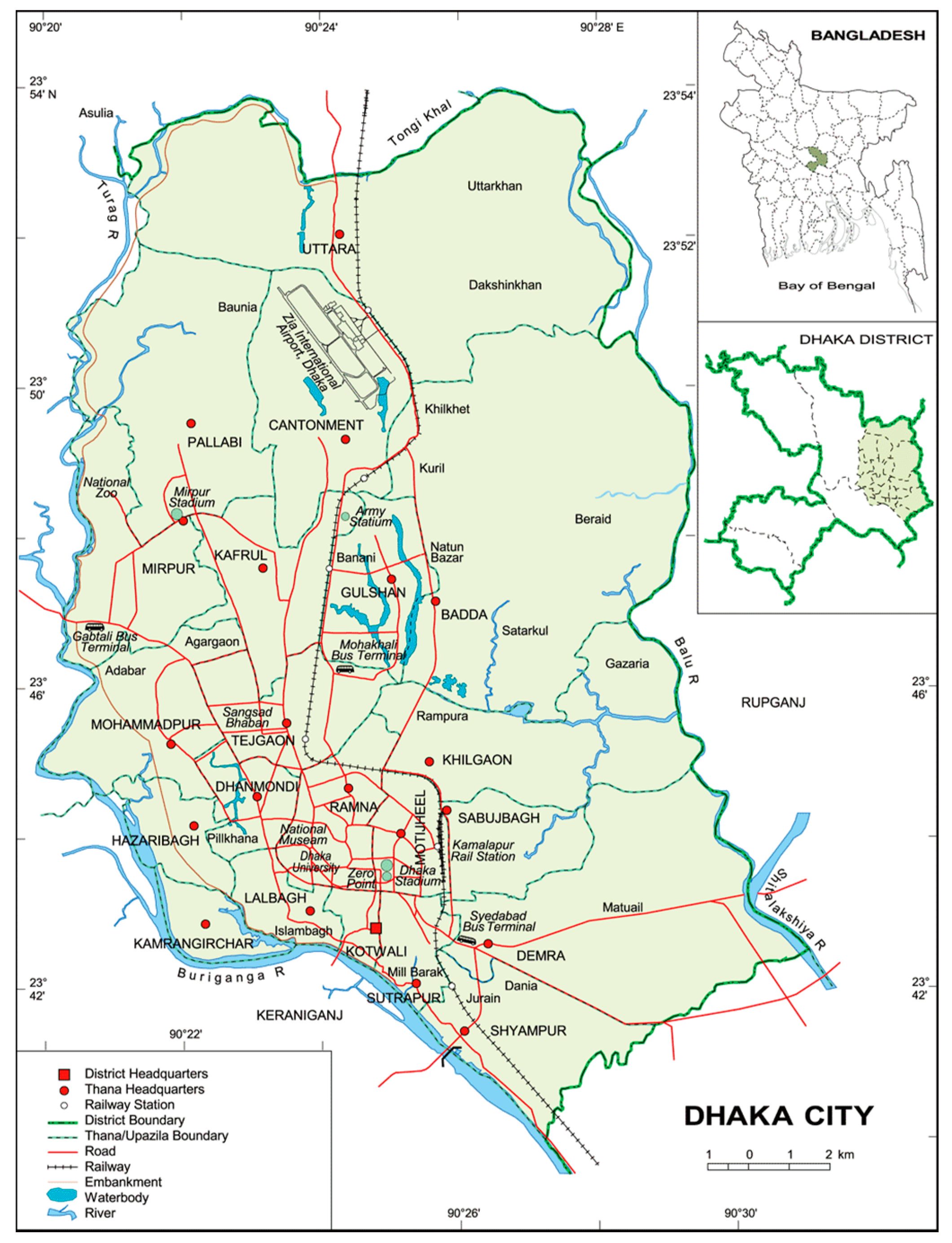
3. Case Study: Dhaka Megacity

3.1. Demographic Profile

Dhaka megacity accommodates around 18.2 million people and this figure is expected to reach 22 million by 2025, at an annual growth rate of 4.4% [9,30]. About 63% of the total population growth is contributed by in-migration, and the remaining growth is due to natural increase [30]. Dhaka megacity is also one of most densely populated cities of the world having a density of 11,910 persons per km2. The density is even higher in the core region of the city (Dhaka North City Council (DNCC) and Dhaka South City Council (DSCC) area), which has significantly increased from 34,629 per km2 in 2001 to 49,182 per km2 in 2011, making it an overcrowded and uninhabitable living environment [4]. The population data also indicates that 40% of the total population represents dependent age groups, leading to a high dependency ratio and widespread poverty among low-earner groups in the city [31]. The key demographic features of the megacity along with the historical trend of population growth are shown in Table 1.
In terms of the core city area government by two corporations, DNCC has an area of 83 km2 comprising a population of 3,957,302. DSCC, on the other hand, has a smaller area of 45 km2 accommodating 2,288,812. The key demographic and urban features of the city corporations are listed in Table 2.
The demographic statistics reveal a higher number of male than female. The city represents people from all regions of Bangladesh. The majority of the population, around 90%, is Muslim and 7% is Hindu, and the rest belong to various religious beliefs. About 40% of the city’s population lives in 4000 slums and squats, of which the majority is female [35,36]. The landownership pattern is highly skewed. More than 70% of the city’s population has no access to land, while only 30% own about 80% of the land [4,10].

3.2. Economy of Dhaka

The urban sector in Bangladesh is the main thrust of the economy, which contributes more than 60% of the GDP [37]. Dhaka is the prime urban agglomeration and economic hub of the country, having a current GDP of US$ 10 billion. The city offers 43.6% of the total formal employment in the country consisting of office jobs, business, and manufacturing industries [30]. The city hosts five key manufacturing industries namely: apparel, textiles, furniture, food and beverage, and leather. Dhaka also provides a large scale of informal jobs, including rickshaw operation, street vending, and household services run by the urban poor. The socio-economic profile of the residents shows extreme inequality between the rich and poor in Dhaka [38]. Only 3% of the total population belongs to the rich cohorts who enjoy a high standard of living. The rest of the population belongs to either the middle or the lower-middle income groups, who have to struggle to sustain their life. Corner and Dewan [4] record that 45% of the city’s population is defined as urban poor, of which 25% are classified as “extremely poor”. The urban poor are mostly located in slum areas of Dhaka city, characterized by a degraded built environment and unhealthy sanitation conditions. Slums accommodate newly arrived environmentally displaced and regular migrants from rural areas. Social clustering based on kinships, district of origin, profession and religion is a very common feature within communities living in slums [10]. Such clusters and social networks provide initial income support, information, accommodation, and access to jobs for newly arrived people.

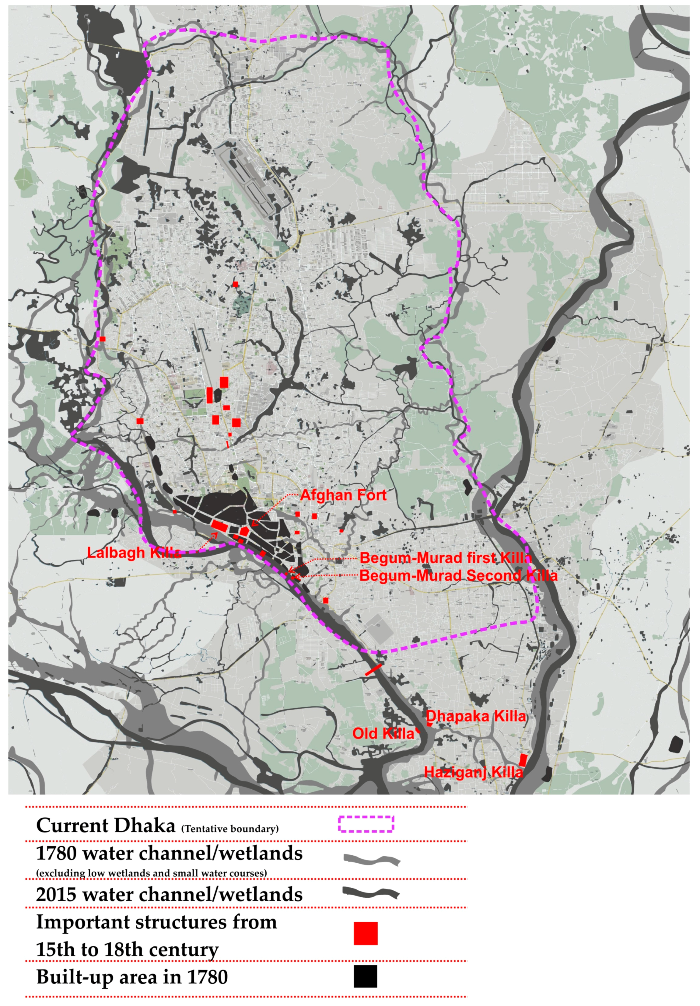
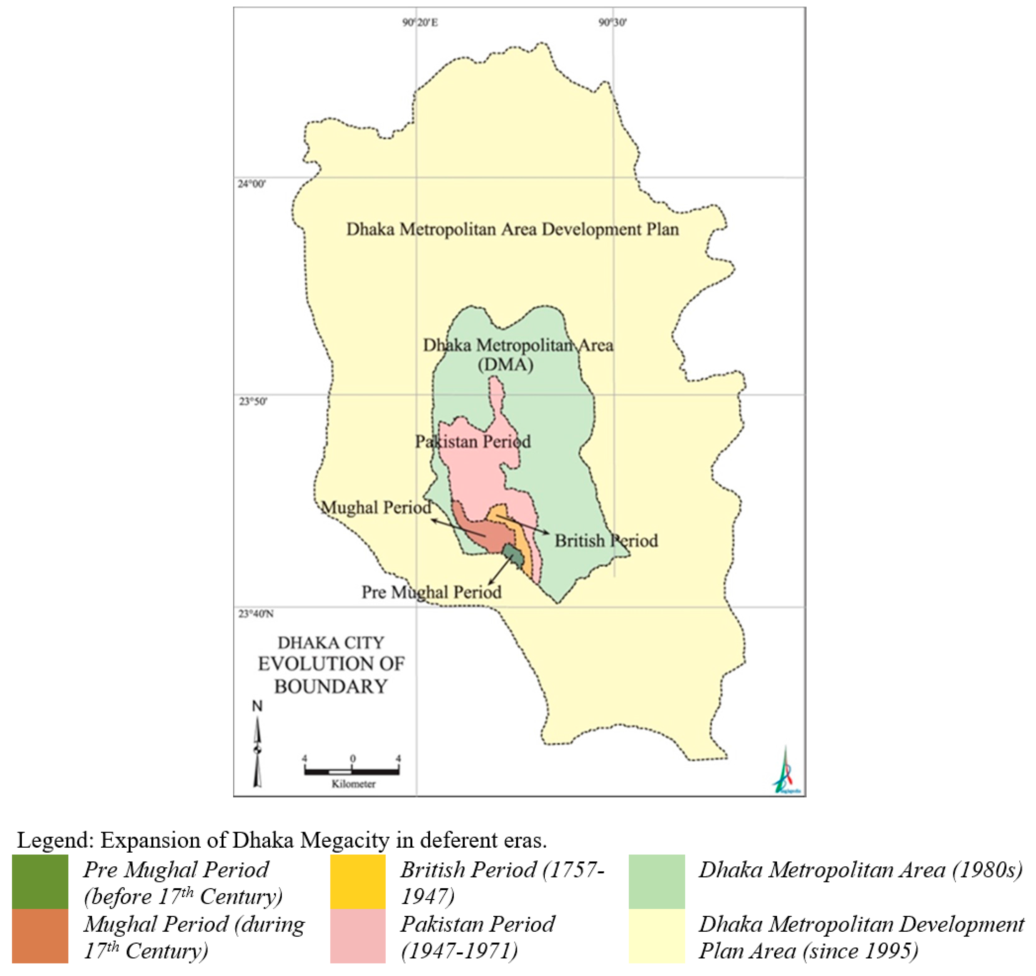
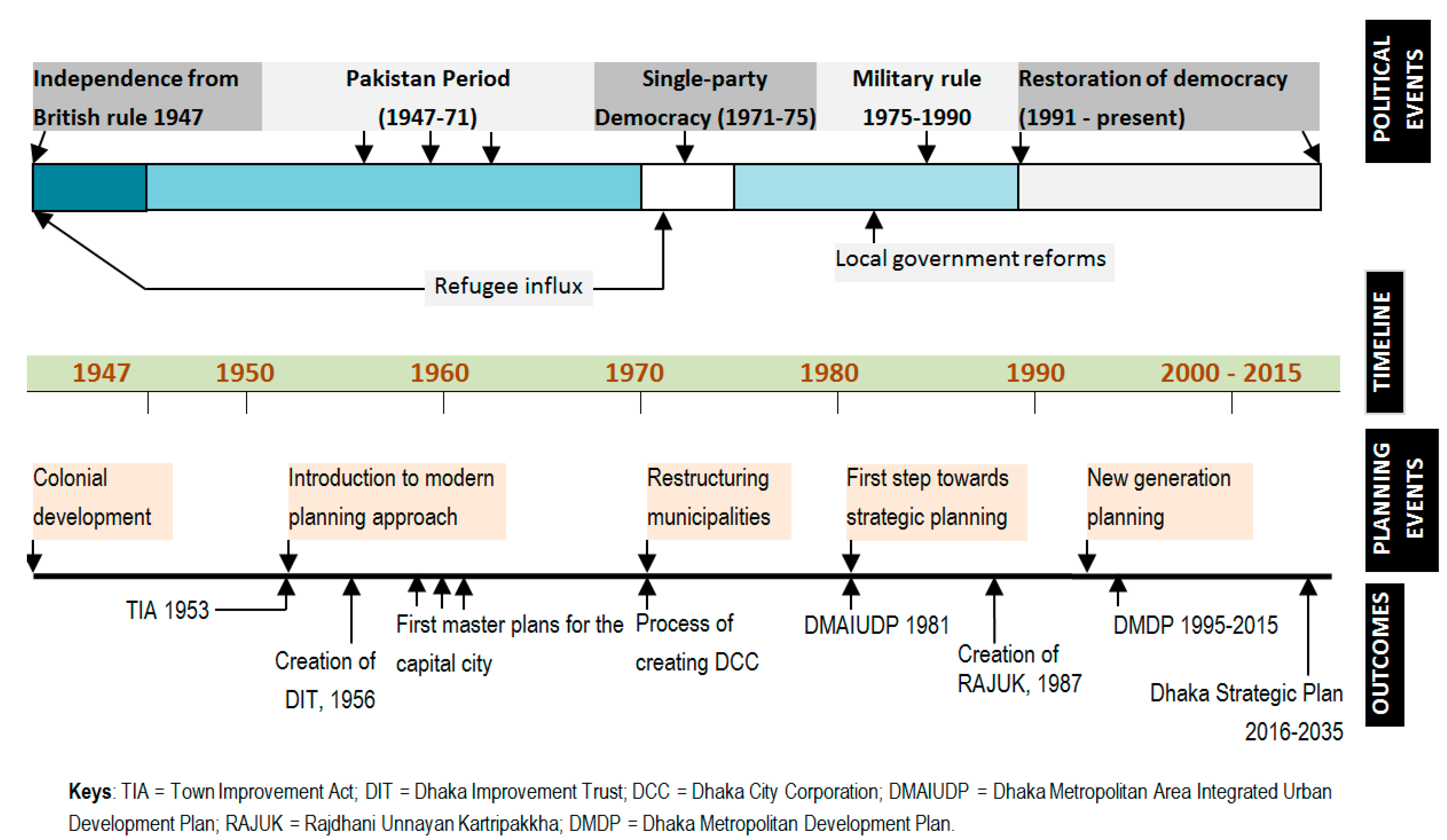
4. Historical Growth and Urban Planning

Dhaka was established nearly 400 years ago [39]. The location of earlier settlements was exceptionally strategic due to its accessibility, water communication and trading routes. The earlier settlements of the city were mainly located on the bank of Buriganga River and have gradually extended towards the north. Due to increasing land scarcity, the city also encroached on low-lying lands on the eastern and westerns sides. The morphology of the city is predominantly spontaneous and organic in nature [40], except for a few planned residential neighborhoods developed after the 1980s.
Pre-Mughal Dhaka was a small settlement in the form of a rural town with a trading center. Dhaka became the capital of the Bengal Subah (province) of the Mughal Empire in 1608 and was named Jahangirnagar, after the Mughal Emperor Jahangir [40,41,42]. Commercial areas in Pre-Mughal Dhaka grew up around “the fort and the river to the west, and the residential areas mostly spread out in the northerly direction” [43]. The size of the city increased from 124 km2 to 248 km2 between early to the late 17th century during the Mughal Empire [44] (Figure 2).
During the early colonial era (1764–1947), the industrial areas were developed by the Europeans including the Dutch, the French, and finally by the British [the Indian sub-continent was ruled by the British East India Company (1757–1857) and the British Crown (1858–1947)] in the 18th century, due to easy water communication and a centralized location [45]. Dhaka appeared as one of the foremost textile-producing cities during the mid-18th century [46].
Dhaka became the capital of the Eastern province of Pakistan in 1947, after the partition of the Indian sub-continent, and hence embarked on becoming a modern metropolis (Figure 3). Post-colonial Dhaka urbanized rapidly, and many new developments took place with the expansion of the city in the north of Dhaka. Motijheel was established in the 1950s as the first central business district (CBD). Later, government housing was built around the CBD. Gradually the majority of the lands that had been gardens, agricultural lands and wetlands were transformed into organic and haphazard built-up areas to accommodate the growing population. The Dhaka Improvement Trust (DIT) was established in 1956 under the Town Improvement Act, 1953, to the guide the planning and development of the city. However, DIT soon developed high-end residential areas such as Gulshan, Banani, Uttara and Baridhara overlooking the largest and growing urban poor [48]. DIT undertook the first masterplan project for Dhaka city in 1959, covering an area of 830 sq. km., targeting one million residents with an annual population growth rate of only 1.75% [23].
Although the metropolitan master plans prepared in the 1960s expired in the early 1980s, no major planning milestones emerged until 1990 due to the major upheavals during independence from Pakistan in the 1970s, and the military takeovers throughout the 1980s [49]. In the early 1990s, the political restoration of democracy in Bangladesh brought about a broad range of reforms in public administration and local governance. In the meantime, DIT was replaced by RAJUK in 1987 under the Town Improvement (Amendment) Act, 1987, through an organizational reform of DIT’s administrative structure and spatial jurisdiction [48].
A paradigm shift towards democratic metropolitan planning that was initiated in the 1970s came to be realized in 1991 when a new phase of spatial planning was reinforced by the new generation plans. RAJUK began its journey through designing the Dhaka Metropolitan Development Plan (DMDP), 1997–2015. Unlike rigid master plans, the new planning approach stated strategies and policies to optimize existing urban land resources in the short to medium term [50]. However, the planning process showed much resemblance with rational planning or Geddesian regional planning approach. The plan was characterized by scoping of an interim review and ensuring sustainable urban development. The aim of the plan illuminates a strong reflection of the development agenda upheld by the international aid organization. The Detailed Area Plan (DAP) proposed under DMDP was not realized until 2010 due to bureaucratic and political barriers. Due to the unavailability of any legal planning framework, haphazard development encroaching wetlands and flood flow zones occurred at a massive scale until 2010 [26]. Although DAP demarcated 21% of the city’s land restricted for development due to its environmental sensitivity, most of those areas appeared as projects already under development by private developers, and in some cases government projects as well.
Poor urban governance also contributed to such unsustainable growth of the city. It is noted that planning and development agencies struggle to control this unplanned growth due to a lack of manpower. Failure or partial implementation of major planning projects is attributed to deep-rooted bureaucracy, lengthy processes of project approval, and above all, the lack of financial and technical capacity of the planning agencies. Ahmed (2010) [51] reports that public departments managed to complete only 71% of the total development projects of the Annual Development Plans during 2000–2008. Meanwhile, the biggest land project, which is around 2500 hectares, has been operated by the public-sector developer RAJUK on the northeastern fringe. In contrast, the binary reality in this century is the reconstruction of the inner-city Hatirjheel-Begunbari canal, which is the major urban water intervention for Dhaka in recent history. The project consists of forty hectares of wetlands integrated with other wetlands, including massive landscape infrastructure systems such as roads, pedestrian walkways, aqueducts, sewerage, water retention, and a special detailed area plan for the surrounding neighborhoods.
Figure 4 summarizes major land use and morphological changes in Dhaka from 1780 to 2015. It illustrates the change of watercourses and declining wetlands along while outlining the growth of the city from only 248 km2 to a 1528 km2 megacity. The land use changes over the centuries suggest significant environmental concerns and the failure of major planning initiatives as mentioned above. Contemporary studies on land use and development patterns indicate that new urban areas and satellite towns are being developed spontaneously and organically on landfills, by both the public and the private sector development agencies [52]. In many cases, however, the quality of development has not been maintained and has resulted in massive disasters. The Ministry of Relief and Disaster Management has identified 72,000 buildings in Dhaka that are at risk to earthquakes [53]. Moreover, “the earthquake disaster risk index has placed Dhaka among the 20 most vulnerable cities in the world” [54].
Social exclusion has been taking place, and a large proportion of climatic and economic migrants are living in the most vulnerable areas of the city along the line of water and land. Eventually constant displacement of these people follows due to the expansion of the city by development agencies, through profit-venture initiatives. Land speculation has become exclusive as land prices have increased by more than 500% over the last 30 years as a result of creating value by developing land for housing and new urban areas [55]. While the implementation of DMDP is still questionable due to political reasons and increasing pressure from private land developers, last year RAJUK released “a revised and updated strategic plan for the Dhaka Metropolitan Region for the period of 2016–2035, keeping in perspective the shifting, underlying philosophies of spatial planning, current situation of this territory, and its future vision for recapturing sustainable city development” [30].
The city was previously administered by the single agency called Dhaka Municipality established in 1864. In 1978, Dhaka Municipality was awarded the status of Corporation. The Local Government (City Corporation) Amendment Act (2011) divided Dhaka City Corporation into Dhaka North City Corporations (DNCC) and Dhaka South City Corporation (DSCC) in 2011 for subdividing the management works [56]. The city corporations are responsible for providing and managing basic urban services, solid waste management and community development and health-related projects. It is also noted that 55 government agencies are responsible for executing various development projects within corporations’ jurisdiction, which often result in overlapping competencies and a clash of authority. The planning process also appears mostly bureaucratic, corrupted and non-participatory. As a result, local demands and aspirations are rarely reflected in the execution of the development plan [26].

5. Challenges of an Emerging Megacity

The trend of urbanization in Dhaka city shows typical growth dynamics of megacities. There is pressing demands for urban infrastructure, utilities, and services such as drainage, water supply, solid waste management, sewerage, sanitation, housing, and transportation. The inadequacy of services and lack of good governance in service delivery has given rise to a critical situation. In addition, the ever-growing population puts significant pressure on the city, as well as on the surrounding environment. The multifaceted challenges have emerged from informal urbanization and have been further deteriorated by natural and man-made hazards. The following sections provide an audit and analysis of significant urban challenges to point out appropriate considerations for making sustainable and resilient urban communities in Dhaka.

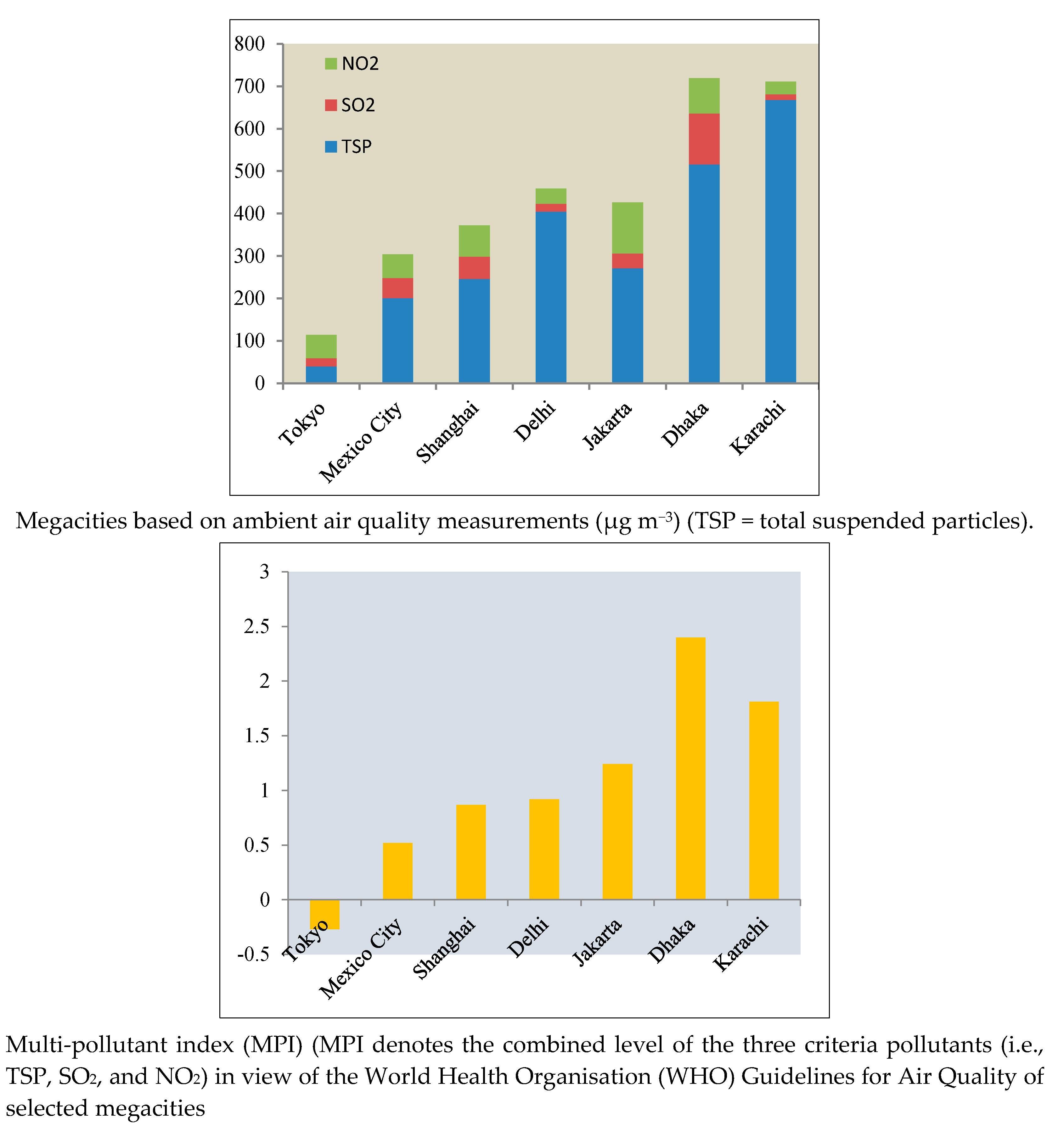
5.1. Impacts of Climate Change

Over 90% of all urban areas are coastal, putting most cities on Earth at risk of flooding from rising sea levels and stronger and more frequent storms [57] and Dhaka is no exception with regards to vulnerability to climate change. The elevation in Dhaka ranges between 2 and 13 meters above sea level, which means that even a slight rise in sea level is likely to engulf large parts of the city [58]. Climate change will affect Dhaka severely through flooding and water congestion and heat stress [59]. A number of studies suggest that climate change will lead to compound problems of environmental degradation [60,61,62,63]. The key vulnerable sectors in Dhaka due to climate change would be agriculture and fisheries, infrastructure such as housing and transportation, utilities services such as water supply and sanitation, power supply, and trade and business industries, which will severely impact on the overall economic activities and most importantly public health and wellbeing [59,64].
Unfortunately, the poorest in society with no or limited access to proper healthcare, water and sanitation are the most vulnerable to the impacts of climate change. The Ministry of Environment and Forests in Bangladesh found that drought will increase in some areas due to declining trend of rainfall patterns induced by climate change [65]. Similar studies found that, in the last 100 years, the average temperature in Dhaka has increased by 0.50 degrees Celsius, and in the next 50 years it is expected to increase by another 1.5–2 degrees [30]. The ageing population and children will be mostly affected from the urban heat island effect, which will intensify due to higher global temperatures. In addition, the distribution of some infectious disease vectors and some allergenic pollen species will increase due to climate change, which would severely affect local health and wellbeing.
Dhaka has already been affected by the indirect impacts of climate change, most particularly from climate-induced displacement and migration. Every year a significant number of people (around 400,000 according to the World Bank’s study) move to Dhaka and live in slums [64]. Due to poor housing structures and lack of utilities and services, around 70% of the slum dwellers in Dhaka are affected by some sort of environment shock and climate change, particularly from floods [66]. Several initiatives to combat the adverse impacts of future risks are underway. Bangladesh Government has prepared a strategic action plan which is built on six key pillars: (i) food security, social protection and health, (ii) comprehensive disaster management, (iii) infrastructure, (iv) research and knowledge management, (v) mitigation and low carbon development, and (vi) capacity building and institutional strengthening. As a part of climate-resilient development, the government has invested around US$10 billion in the past three decades primarily in flood management [Greater Dhaka Flood Protection Project’ (GDFPP)], improving drainage systems, embankments, coastal projection, and cyclone shelter-related projects [67]. Recently a US$2 billion embankment project funded by the United Nations and the Netherlands Government is being implemented nationwide to stop flood risks [68]. Apart from mitigation actions, significant efforts have been attributed to developing adaptation strategies. This includes stabilizing housing structures of low-income settlements, introducing floating gardens to continue food production during floods and diversifying agricultural cropping systems [69].

5.2. Water Supply

Water supply in Dhaka primarily relies on ground water sources. Around 80% of the total water supplied by the Dhaka Water Supply and Sewerage Authority (DWASA) in the city comes from ground water (with a 26% system loss) and another 20% from surface water sources [30]. The water demand in 2015 was 3140 million liters per day (MLD) and the demand will increase to 4858 MLD by 2035 [30]. A study from the Institute of Water Modelling suggests that around 149,160 million liters of water (47 days of current water demands) can be harvested during the monsoon season, using rainwater-harvesting systems [70]. DWASA covers around 75% of the metropolitan areas with a supply of piped water to 12.5 million residents, whereas 25% of the residents (including slum dwellers) face water shortages on account of inadequate water supply [70]. Poor maintenance of the water supply system and power blackouts often interrupt the water supply system in Dhaka. Most of the slum dwellers (about 4.1 million out of 4.5 million) do not have formal access to the DWASA water supply system [71]. A constant withdrawal of groundwater from the Dhaka catchment areas creates huge risks of the gradual depletion of the groundwater level and pollutes the groundwater with arsenic, dissolved ammonia, iron and manganese. It is noted that due to heavy pollution and contamination of surface water from domestic waste and sewage systems, Dhaka will face significant challenges in sourcing drinking water.

5.3. Solid Waste Management (SWM)

Each day the residents of Dhaka generate around 4000 tons of solid waste including industrial waste (300 t/day) and medical waste (200 t/day) with a generation rate of 0.34 kg/person/day [30]. Due to a lack of funds and infrastructure, DNCC and DSCC only collected half of the waste generated by its residents in 2012 [72]. Only 14–17% of the total municipal budget is used for SWM, which is approximately US$ 0.5 per capita per year [73]. The waste management system in Dhaka is primarily operated by the community-based informal collection and recycling system. About 120,000 people are involved in the informal recycling trade chain in Dhaka City. Any valuable materials are either reused or sold by their owners or by the informal waste-pickers. The formal waste collection system that the DCC provides to the residents is facilitated through 1030 roadside containers and 41 private containers [74]. A recent report showed that the DCC only operates around 511 garbage containers in different areas of Dhaka city [75], which is equivalent to one bin for every 32,093 people. Due to the lack of a waste infrastructure that is hampered by a narrow road network, the DCC does not provide any door-to-door collection systems. From its roadside collection points, the DCC collects waste and transfers it to landfill sites. Community-based private micro-organizations collect waste from households instead, and transfer this to the DCC’s designated waste collection and transfer points.

5.4. Drainage and Hydrology

Dhaka is situated in a low-lying area with a high risk of flooding, as the city is surrounded by a number of major rivers and more than 50 water channels [76]. This makes Dhaka’s surface hydrology very complex. As part of its flood protection strategy, Dhaka implemented a number of dykes or embankments and interim boundaries. This also creates water logging within the protected city area during the monsoons, as there are insufficient drainage and water pumping systems. Studies reveal that permanent wetlands have been reduced from 14% to 4% between 1967 and 2010 and during the same time period Dhaka lost around 52% lowlands and 33% water bodies around Dhaka city [30].
Dhaka built its first city protection embankment after the 1988 flood on the western edge along with a bypass road. This western development model transformed the water system from natural and gravity drainage to mechanical pumping drainage for western Dhaka, which needed a huge amount of energy to operate. Moreover, fortification against water, instead of living with water, altered the land formation pattern in Dhaka; hence land developers and illegal occupiers filled land without any consideration for natural drainage or the ecosystem. This proved to be cataclysmic in the long run. In addition, unplanned underground drainage systems across the city lead to severe waterlogging on the streets. A World Bank study predicts a cumulative financial loss of around US$ 1.4 billion in the next 35 years, if waterlogging and urban flooding are not addressed [77].

5.5. Sewerage and Sanitation

The underground sewer network provided by the DWASA covers only 30% of the urban land area and 20% of the population [30]. Another 30% of the population is estimated to dispose off their sewage by connecting into the drainage networks and open channels. The remaining 50% of the residents in Dhaka are served by localized sanitation facilities like septic tanks and soak pits that are, for the most part, poorly or inadequately designed. The sanitation facilities in slum areas are even shabbier. A large amount of domestic and human waste is held in situ these areas, some of which gets washed into the water bodies during the wet season. This leads to the proliferation of viral diseases and communicable diseases due to poor hygiene and non-existent sanitation systems in the slums. DWASA operates only one sewage treatment plant at Pagla (PSTP), about 8 km from the city, on an area of 1.105 km2. PSTP has a design capacity of 120 MLD (peak flow rate) while the current sewage generated within the catchment areas, served by the centralized sewerage system is approximately 250–300 MLD. Due to damage to the trunk sewer mains and sewerage system, the actual flow rate entering the Pagla STP is approximately 30–40 MLD, i.e., the treatment plant is significantly under-loaded and should ideally provide a high level of treatment [30].

5.6. Formal vs. Informal Housing

Dhaka faces extreme challenges in housing and related infrastructure due to rapid population growth and an influx of the migrant population. According to Seraj and Islam [78], every year at least 100,000 new housing units are required in Dhaka to fulfill the growing housing demand. Around 90% of the total housing supply in Dhaka is provided by private housing sector, and public housing only accommodates around 10% of the market supply [30]. Often the housing development in Dhaka follows an unplanned and informal “incremental development” model where the housing along with the relevant service infrastructure is developed in various steps by adding a “little more” each time. This unplanned informal incremental development leads to violating building codes and a lack of necessary safety features for the infrastructure.
The total housing shortage in Bangladesh was estimated to be 5.0 million units by the end of the year 2000. In response to this demand, roughly 25,000 housing units are supplied annually by the private sector, while the government contributes a very negligible portion [79]. The demand for vertical expansion in Dhaka has increased exponentially in recent years as land is scarce, and an increasing population, accompanied by urban migration, has increased the demand for housing [80]. High-rise residential development has also gained popularity, as the horizontal expansion of Dhaka is not possible due to a lack of buildable land within the city center [45], and barriers such as the built-up urban core and the low-lying flood plains [28,77,80]. Private real estate companies emerged in Dhaka in the early 1980s with residential apartment development projects. The number of real estate companies has increased dramatically from only 42 in 1988 to more than 1500 in 2014. A recent study has identified 181 residential settlement development projects (plots and apartments) in the greater Dhaka city area [81].
However, the location of the projects indicates an outward trend, occupying peripheral areas, spontaneously resulting in significant environmental concerns. Moreover, the quality of the residential buildings in the new schemes has deteriorated due to wetland encroachments, violations of predefined land use, illegal plot subdivisions, and increased building heights. Besides, over 78% of the lower middle-income group and 70.73% of the middle-income families cannot afford housing in the city [30] as it serves only the upper strata of the society. As a result, most of the people either rent in unplanned peripherals or squat illegally in slum areas. Dhaka has the highest slum population among six major cities in Bangladesh. Since informal settlements are not recognized by the legal judicial systems due to land ownership and other legal disputes, almost all informal settlements in Dhaka have no provision of the most basic urban services such as water supply, sanitation and energy supply. As a result, housing and living conditions in the slums are very poor and often associated with a higher level of health risks.

5.7. Transport

The public transport system in Dhaka does not meet the requirements of its population and people heavily depend on private cars and non-motorized rickshaws (three-wheeler cycle). The transport system in Dhaka is significantly problematic due to a lack of proper infrastructure, inadequate motorized public transport, and disregard of traffic rules. Every day an estimated 442,000 commuters use 183 transport routes, including air, water, rail and roads [30]. Dhaka’s public transport comprises “a fragmented, loosely organized, and weakly regulated system of approximately 7000 buses and minibuses”, which is managed by more than 60 companies [82]. A study on the travel pattern of Dhaka city reports that work-based travelling accounts for 44.7% of the total trips generated by inhabitants [6]. Other significant trips are generated for school (17.7%) and homes (12.6%). Air pollution from transportation is a major concern for Dhaka. Dhaka has the highest air pollution in the context of ambient air quality and multi-pollutant index compared to other mega cities (Figure 5).
The mobility pattern of Dhaka remains highly human-powered as 64% of trips in the city are by rickshaw, 28% by bus, and the remaining are related to car, motorbike and auto-rickshaw [84]. It is expected that by 2035 the modal share of public transport will increase significantly, whereas the modal share of rickshaw trips will decrease to 20% [30]. Dhaka not only faces the challenges of a poor and insufficient road network, but it also faces challenges from vehicle conditions. Over 95% of the buses that operate everyday do not comply with the requirements under the Motor Vehicles Act, and only 75,000 rickshaws have legal permits against a total of 700,000 rickshaws operating in the city [85]. Vehicular emission is one of the main sources of air pollution as it imposes a significant health risk to the residents of Dhaka. The city also had the worst multi-pollutant index (MPI) of all the megacities in 2000, which was caused by an ever-growing population, unfit vehicles, and low-quality fuel [6] (Figure 5).
Dhaka’s transport sector experiences a very high congestion level due to a higher population density, a poor mix of land uses, and limited space for new transport infrastructure. Frequent traffic congestion is severely detrimental to the working population as well as to the overall economy. It is estimated that congestion costs US$3 billion a year and the city loses over 8 million working hours daily [86]. As part of the traffic solution, the government has undertaken comprehensive transport planning and infrastructure programs. Among others, the Dhaka elevated expressway, around 47 km long, is one of the biggest transport infrastructure projects with a budget of US$1.2 billion, and it will be completed under a public-private partnership approach. However, traffic experts do not find flyover projects an effective solution, because 650 street intersections in Dhaka need to be made functional first in order to address this problem [87].

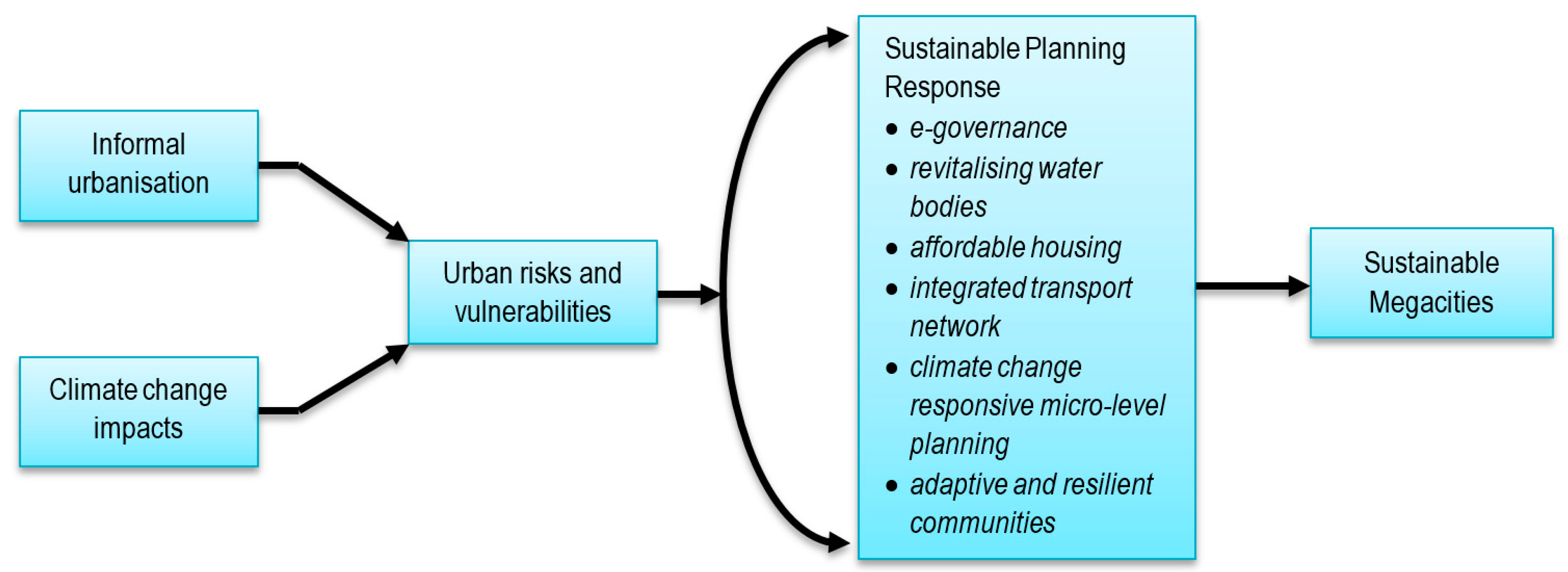
6. Discussion: Planning for Future Sustainability

This article provides a profound picture of the historical evolution of Dhaka to understand its growth and contemporary issues. The paper tries to emphasize the issue of urban population growth and its multifaceted impact on a city’s infrastructure and development. It is evident that the increasing gap between economic opportunities and service provisions is leading to inadequate infrastructural services and urban life style. While the policy makers have bigger plans to make Dhaka a livable and more resilient metropolis, the challenges should be handled efficiently and collaboratively. Figure 6 portrays the overall framework for an integrated and sustainable response for making cities livable and resilient. The premise of the framework supports a holistic approach to address the emerging urban issues that prevail in megacities. The following sections discuss the opportunities and pathways to overcome the risks and challenges of Dhaka, which are identified and analyzed in Section 4.
Urban planning systems in Bangladesh are characterized by a top-down planning approach influenced by politicized patron-client networks and bureaucracy. The administrative practice and service delivery approach growing out of its colonial legacy are predominantly manual and paper-based. In terms of planning administration, large land-related databases are manually recorded and physically filed in numerous bound register books accompanied by hand-drawn maps using pen and paper. This inefficient and cumbersome system thus tends to contribute to non-transparent systems subject to delayed processing of citizens’ requests for information and susceptible to potential corruption and wastage of resources. Tracing progress of applications for building approvals, for example, can be difficult simply due to manual data storage and retrieval, and also often due to deliberate corruption.
The journey from city management to modern urban planning practice suggests that a number of opportunities to develop local institutional capacities and systems may have been wasted. As European colonizers left, “western” systems continued to be incorporated, taking the focus away from the need to adopt, augment, and revive traditional governance and administration systems. The challenge of dealing with an unprecedented influx of refugees and migrants could largely explain why urban administrators opted for the imported state-of-the-art planning technology to handle large problems through equally large-scale plans. Consequently, knowledge of the local context or cultural sensitivity did not significantly temper the planning approach. A good-governance framework also suggests formal access to the information of land, property and housing. There is a growing demand in improving e-government to ensure efficient information management and effective urban service delivery systems [88].
The infrastructural development trend in Dhaka mostly follows an “incremental development model”, where development activities occur incrementally, depending on the then-prevailing needs and circumstances. However, by comparison, the pace of infrastructure development significantly lags behind urbanization over time. One of the key reasons is the lack of integration between the development plan and the implementation of recommended development strategies. The protection of water bodies and natural channels is very important in order to ensure an effective drainage system in Dhaka. The provision of separate sewage and storm water drainage facilities are required in this megacity to improve health and sanitation. The city also needs to revitalize the surrounding rivers urgently, so that surface water can be used for its water supply instead of ground water. An effective waste management system is considered to be a benchmark of good governance; unfortunately, Dhaka cannot even collect 100% of the waste generated by its residents on a day-to-day basis. The integration of the informal waste recycling system under the aegis of greater public-private participation would improve the overall waste management system in Dhaka.
The housing sector faces various challenges too, as there is a lack of proper control in both formal and informal development processes. The public housing agency should provide more affordable housing, as the average housing prices are beyond the financial capacity of most of the lower- and middle-income people in Dhaka. The government should provide financial assistance and sustainable guidelines for a neighborhood-based development model instead of a plot-based model or apartment housing. Improving living conditions in slum areas is also critical as more than one third of Dhaka’s residents are living in these areas.
The city has taken several initiatives such as the development of an elevated expressway, flyovers and the plan of rapid transit systems, which would improve the mobility of people in Dhaka. Constructing ring roads and revitalizing the surrounding waterways can significantly improve the overall transportation system in Dhaka. Imposing higher penalties for traffic violations could also contribute to the improvement of transport systems in the city. All these initiatives should be undertaken through an integrated and good-governance framework, since urban planning, land use, and infrastructure are inter-linked and complex in nature. The megacity thus requires immediate attention to modernize its planning functions and services for sustainable growth, and for utilizing the complete potential of the people, economy and infrastructure.
Finally, while the megacities in developing countries are not the major contributors of greenhouse gas (GHG) emissions, there is a “growing exposure and vulnerability of these cities to climate change, due to a combination of poor socio-economic conditions and inefficient urban planning and management” [28]. It requires sound land-use planning and consensus-based implementation mechanisms to stop the trend of informal urbanization process. In addition, regenerating alternative urban centers can be useful to decentralize the flow of rural-urban migration. A number studies suggest various adaptive measures including urban agriculture for food security during a disaster period, prioritizing risks and vulnerabilities to take graduated actions, and practicing more inclusive planning for local decision making [89]. A new wave of literature highlights the importance of improving social networks of individuals with relatives, immediate neighbors and local institutions, which has potential for making communities more resilient and capable of fast recovery from shocks [90]. However, it is imperative to ensure integration among all the sectors to achieve a sustainable growth within the current urban context.

7. Conclusions

In this paper, we have tried to trace the growth of a megacity and its informal urbanization process in Dhaka. In this regard, we have shed light on urban planning and development issues that affect the livelihoods of the urbanites. The analysis reveals the root cause of the problem and has shown how overwhelming population and increasing density exerts pressure on infrastructure and local environment. Since the scope of a horizontal expansion is limited and challenging due to low-lying flood plain agricultural land in the surrounding peri-urban area, vertical expansion is undeniably an option for accommodating the growing urban population in Dhaka. Unfortunately, most of the housing development in Dhaka is currently driven by private entities following an unplanned incremental development model with limited supervision and assistance from local government, which often leads to the violation of building codes and unsafe construction practices.
Moreover, climatic hazards intensify the magnitude of the problems, leaving citizens with an undefined future. Dhaka is currently facing multifaceted urban challenges due to a lack of good governance. The Detailed Area Plan proposed under DMDP does not integrate and consider local stakeholders’ interests, which makes it more challenging to successfully implement DAP in Dhaka.
The findings of the article communicate critical urban challenges to the academics and the practitioners to guide the development patterns of the cities that accommodate the largest concentrations of urban population. The audit and analysis of the urban challenges suggest the development of a more comprehensive and integrated planning framework that recognizes the interrelationships of multifaceted problems. A greater role of promoting awareness, self-efficacy and improved social capital needs to be equally voiced to ensure a sustainable growth of megacities such as Dhaka.

Author Contributions

Mohammad Swapan and Atiq Zaman conceived and designed the research paper. Mohammad Swapan developed the theoretical orientation and contributed in exploring planning history of Dhaka and the discussion sections. Atiq Zaman and Tahmina Ahsan analyzed the urban challenges of megacity and the conclusion. Fahmid Ahmed contributed in describing the historical development of Dhaka and prepared the map to trace the land use changes.

Conflicts of Interest

The authors declare no conflict of interest.

References

  1. Pelling, M.; Blackburn, S. (Eds.) Executive Summary. In Megacities and the Coast: Risk, Resilience and Transformation; Routledge: New York, NY, USA, 2013. [Google Scholar]
  2. Taubenböck, H.; Esch, T.; Felbier, A.; Wiesner, M.; Roth, A.; Dech, S. Monitoring urbanization in mega cities from space. Remote Sens. Environ. 2012, 117, 162–176. [Google Scholar] [CrossRef]
  3. UN. World Urbanization Prospects (The 2011 Revision); United Nations: New York, NY, USA, 2012. [Google Scholar]
  4. Corner, R.J.; Dewan, A.M. (Eds.) Introduction. In Dhaka Megacity: Geospatial Perspectives on Urbanisation, Environment and Health; Springer: New York, NY, USA, 2014; pp. 1–22. [Google Scholar]
  5. Yokohari, M.; Takeuchi, K.; Watanabe, T.; Yokota, S. Beyond greenbelts and zoning: A new planning concept for the environment of Asian mega-cities. Landsc. Urban Plan. 2000, 47, 159–171. [Google Scholar] [CrossRef]
  6. Kabir, A. The Urban Spatial Structure of Employment and Its Impacts on Transportation and Urban Development: A Case Study of Dhaka Megacity; University of New South Wales: Sydney, Austrilia, 2013. [Google Scholar]
  7. UN. World Urbanization Prospects (The 2014 Revision); United Nations: New York, NY, USA, 2015. [Google Scholar]
  8. WB. System of Cities—Harnessing Urbanization for Growth and Poverty Alleviation; World Bank: Washington, DC, USA, 2009. [Google Scholar]
  9. UN. The World’s Cities in 2016. In World Urbanization Prospects: Data Booklet (ST/ESA/SER.A/392); United Nations: New York, NY, USA, 2016. [Google Scholar]
  10. Hossain, S. Social formations of the megacity of Dhaka: A review essay. Cities 2013, 30, 252–254. [Google Scholar] [CrossRef]
  11. Bhattacharjee, P.P.; Khan, M.R. Govt to Double Size of Dhaka City Area. Available online: http://www.thedailystar.net/frontpage/govt-double-size-dhaka-city-area-1219972 (accessed on 10 May 2017).
  12. DNCC. Dhaka North City Corporation at a Glance; Dhaka North City Council: Dhaka, Bangladesh, 2017.
  13. Islam, S. Banglapedia—The National Encyclopedia of Bangladesh; Dhaka City Corporation: Dhaka, Bangladesh, 2012. [Google Scholar]
  14. Degert, I.; Parikh, P.; Kabir, R. Sustainability assessment of a slum upgrading intervention in Bangladesh. Cities 2016, 56, 63–73. [Google Scholar] [CrossRef]
  15. Haque, S.J.; Onodera, S.; Shimizu, Y. An overview of the effects of urbanization on the quantity and quality of groundwater in South Asian megacities. Limnology 2013, 14, 135–145. [Google Scholar] [CrossRef]
  16. Roy, A. Urban informality: Toward an epistemology of planning. J. Am. Plan. Assoc. 2005, 71, 147–158. [Google Scholar] [CrossRef]
  17. McGee, T.G. The emergence of desakota regions in Asia: Expanding a hypothesis. In The Extended Metropolis: Settlement Transition in Asia Ginsburg; University of Hawaii Press: Honolulu, HI, USA, 1991. [Google Scholar]
  18. Hackenbroch, K.; Hossain, S.; Altrock, U.; Schoon, S.; Sterly, H. Informality, urban governance and the state: Negotiations of space in Dhaka and the Pearl River Delta. Int. Dev. Plan. Rev. 2016, 38, 229–253. [Google Scholar] [CrossRef]
  19. Hossain, S. The production of space in the negotiation of water and electricity supply in a bosti of Dhaka. Habitat Int. 2012, 36, 68–77. [Google Scholar] [CrossRef]
  20. Daniels, P.W. Urban challenges: The formal and informal economies in mega-cities. Cities 2004, 21, 501–511. [Google Scholar] [CrossRef]
  21. Porter, L.; Lombard, M.; Huxley, M.; Ingin, A.K.; Islam, T.; Briggs, J.; Rukmana, D.; Devlin, R.; Watson, V. Informality, the commons and the paradoxes for planning: Concepts and debates for informality and planning self-made cities: Ordinary informality? The reordering of a Romany neighbourhood the land formalisation process and the peri-urban zone of Dar es Salaam, Tanzania street vendors and planning in Indonesian cities informal urbanism in the USA: New challenges for theory and practice engaging with citizenship and urban struggle through an informality lens. Plan. Theory Pract. 2011, 12, 115–153. [Google Scholar]
  22. Baumgart, S.; Kreibich, V. Informal Urbanization—Historical and Geographical Perspectives. disP Plan. Rev. 2011, 47, 12–23. [Google Scholar] [CrossRef]
  23. Bari, M.; Efroymson, D. Detailed Area Plan (DAP) for Dhaka Metropolitan Development Plan (DMDP): A Critical Review; WBB Trust: Dhaka, Bangladesh, 2009. [Google Scholar]
  24. Khan, M.H. Patron-client networks and the economic effects of corruption in Asia. Eur. J. Dev. Res. 1998, 10, 15–39. [Google Scholar] [CrossRef]
  25. Sarker, A.E. Patron-client politics and its implications for good governance in Bangladesh. Int. J. Public Adm. 2008, 31, 1416–1440. [Google Scholar] [CrossRef]
  26. Swapan, M.S.H. Who participates and who does not? Adapting community participation model for developing countries. Cities 2016, 53, 70–77. [Google Scholar] [CrossRef]
  27. TIB. TIB Condemns Government Decision to Legalize Illegal Housing Projects; Demands Cancellation; Transparency International Bangladesh: Dhaka, Bangladesh, 2012. [Google Scholar]
  28. Roy, M. Planning for sustainable urbanisation in fast growing cities: Mitigation and adaptation issues addressed in Dhaka, Bangladesh. Habitat Int. 2009, 33, 276–286. [Google Scholar] [CrossRef]
  29. Kraas, F. Megacities and global change: Key priorities. Geogr. J. 2007, 173, 79–82. [Google Scholar] [CrossRef]
  30. RAJUK. Dhaka Structure Plan 2016–2035; Rajdhani Unnayan Kartripakkha: Dhaka, Bangladesh, 2015.
  31. Mridha, A.M.M.H.; Moore, G.T. The Quality of Life in Dhaka, Bangladesh: Neighborhood Quality as a Major Component of Residential Satisfaction. In Investigating Quality of Urban Life: Theory, Methods, and Empirical Research; Marans, R.W., Stimson, R.J., Eds.; Springer: New York, NY, USA, 2005. [Google Scholar]
  32. BBS. Population Census—2001 (Vol. 3): National Series, Urban Area Report; Bangladesh Bureau of Statistics: Dhaka, Bangladesh, 2008. [Google Scholar]
  33. BBS. Population and Housing Census 2011 (Community Series)—Dhaka, Gazipur, Narayanganj; Bangladesh Bureau of Statistics: Dhaka, Bangladesh, 2012. [Google Scholar]
  34. DSCC. Dhaka South City Corporation—Services; Dhaka South City Council: Dhaka, Bangladesh, 2017. [Google Scholar]
  35. Islam, N.; Mahbub, A.; Nazem, N.I.; Angeles, G.; Lance, P. Slums of Urban Bangladesh : Mapping and Census, 2005; Centre for Urban Studies, NIPORT and MEASURE Evaluation: Dhaka, Bangladesh, 2006. [Google Scholar]
  36. Mahmud, S. Women and the transformation of domestic spaces for income generation in Dhaka bustees. Cities 2003, 20, 321–329. [Google Scholar] [CrossRef]
  37. Choe, K.; Roberts, B. Competitive Cities Competitive Cities in the 21st Century: Cluster-Based Local Economic Development Mandaluyan City; Asian Development Bank: Manila, Philippines, 2011. [Google Scholar]
  38. Siddiqui, K.; Ahmed, J.; Siddique, K.; Huq, S.; Hossain, A.; Nazimud-Doula, S.; Rezawana, N. Social Formation in Dhaka, 1985–2005: A Longitudinal Study of Society in a Third World Megacity; Ashgate Publishing Limited: Farnham, UK, 2010. [Google Scholar]
  39. Ahmad, S.; Balaban, O.; Doll, C.N.; Dreyfus, M. Delhi Revisited. Cities 2013, 31, 641–653. [Google Scholar] [CrossRef]
  40. Mahmud, S.; Duyar-Kienast, U. Spontaneous settlements in Turkey and Bangladesh: Preconditions of emergence and environmental quality of gecekondu settlements and bustees. Cities 2001, 18, 271–280. [Google Scholar] [CrossRef]
  41. Ahmed, S.U. Dhaka Past, Present, Future; Asiatic Society of Bangladesh: Dhaka, Bangladesh, 2009. [Google Scholar]
  42. Chowdhury, M.; Shahidul, H. Growth of capital Dhaka 1608–2010. In 400 Years of Capital Dhaka and Beyond; Hafiz, R., Rabbani, G., Eds.; Asiatic Society Bangladesh: Dhaka, Bangladesh, Bangladesh, 2011. [Google Scholar]
  43. Ahmed, S.J.; Nahiduzzaman, K.M.; Bramley, G. From a Town to a Megacity: 400 Years of Growth. In Dhaka Megacity: Geospatial Perspectives on Urbanisation, Environment and Health; Corner, R.J., Dewan, A.M., Eds.; Springer: New York, NY, USA, 2014; pp. 23–44. [Google Scholar]
  44. Karim, A. Origin and development of Mughal Dhaka. In Dhaka: Past Present Future, 2nd ed.; Ahmed, S.U., Ed.; The Asiatic Society of Bangladesh: Dhaka, Bangladesh, 2009; pp. 34–55. [Google Scholar]
  45. Chowdhury, A.; Faruqui, S. Physical growth of Dhaka city. In Dhaka: Past Present Future, 2nd ed.; Ahmed, S.U., Ed.; The Asiatic Society of Bangladesh: Dhaka, Bangladesh, 2009; pp. 56–76. [Google Scholar]
  46. Mohaimen, A. Dhaka Master Plan Report of 1917 by Patrick Geddes; Bangla Translated Version with an Introduction; Dhaka City Museum: Dhaka, Bangladesh, 1990. [Google Scholar]
  47. Banerjee, T.; Chakravorty, S. Transfer of Planning Technology and Local Political Economy: A Retrospective Analysis of Calcutta’s Planning. J. Am. Plan. Assoc. 1994, 60, 71–82. [Google Scholar] [CrossRef]
  48. Rahman, G. Town Planning and Political Culture of Planning in Bangladesh; A H Development Publishing House: Dhaka, Bangladesh, 2008. [Google Scholar]
  49. Westergaard, K.; Alam, M. Local government in Bangladesh: Past experiences and yet another try. World Dev. 1995, 23, 679–690. [Google Scholar] [CrossRef]
  50. RAJUK. Dhaka Metropolitan Development Planning: Terms of Reference (TOR) for Detailed Area Plan; Rajdhani Unnayan Kartripakkha: Dhaka, Bangladesh, 2000.
  51. Ahmed, S. Problems of ADP Implementation in Bangladesh: An Analytical Review; BRAC University: Dhaka, Bangladesh, 2010. [Google Scholar]
  52. Hossain, N. History of Commercial Development in Dhaka and the Spatial Significance of Spontaneous Retail Growth. IOSR J. Humanit. Soc. Sci. IOSR-JHSS 2014, 19, 66–73. [Google Scholar] [CrossRef]
  53. Mamun, S. Earthquake: 72,000 buildings at risk in Dhaka. Available online: http://archive.dhakatribune.com/bangladesh/2016/jan/04/72000-building-risk-during-earthquake-dhaka (accessed on 10 May 2017).
  54. Ahmed, S.; Ahmed, A.T. Disaster Risks and Risk Mitigation in Dhaka/Other Cities. In Proceedings of the Global Campaign on Making Cities Resilient, New Delhi, India, 8–9 June 2010. [Google Scholar]
  55. Hafiz, R. The Urban Frontiers of Dhaka: Creating Space above the Water. In Urbanization in Bangladesh: Emerging Challenges; Jahan, S., Zaman, M., Eds.; Bangladesh Institute of Planners: Dhaka, Bangladesh, 2004. [Google Scholar]
  56. DSCC. About DSCC (Dhaka South City Corporation); Dhaka South City Corporation: Dhaka, Bangladesh, 2012. [Google Scholar]
  57. C40. Ending Climate Change-Begins in the City. Available online: http://www.c40.org/ending-climate-change-begins-in-the-city (accessed on 15 May 2017).
  58. UN-Habitat. State of the World’s Cities 2008/2009—Harmonious Citie; United Nations Human Settlements Programme: London, UK, 2008. [Google Scholar]
  59. Alam, M.; Rabbani, M.G. Vulnerabilities and responses to climate change for Dhaka. Environ. Urban. 2007, 19, 81–97. [Google Scholar] [CrossRef]
  60. Amin, S.M.A.; Rahman, A. Opportunities and Challenges of Urban and Peri-urban Agriculture to Face Climate Change: A Critical Analysis of Policy and Urban Governance of Dhaka City. In The Security of Water, Food, Energy and Liveability of Cities; Springer: New York, NY, USA, 2014; pp. 365–382. [Google Scholar]
  61. Araos, M.; Ford, J.; Berrang-Ford, L.; Biesbroek, R.; Moser, S. Climate change adaptation planning for Global South megacities: The case of Dhaka. J. Environ. Policy Plan. 2016. [Google Scholar] [CrossRef]
  62. Banu, S.; Hu, W.; Guo, Y.; Hurst, C.; Tong, S. Projecting the impact of climate change on dengue transmission in Dhaka, Bangladesh. Environ. Int. 2014, 63, 137–142. [Google Scholar] [CrossRef] [PubMed] [Green Version]
  63. Black, R.; Kniveton, D.; Schmidt-Verkerk, K. Migration and climate change: Toward an integrated assessment of sensitivity. In Disentangling Migration and Climate Change; Springer: New York, NY, USA, 2013; pp. 29–53. [Google Scholar]
  64. Rahman, A.; Mallick, D. Climate change impacts on cities of developing countries: A case study on Dhaka. In Proceedings of the C40 Tokyo Conference on Climate Change—Adaptation Measures for Sustainable Low Carbon Cities, Tokyo, Japan, 22–24 October 2008. [Google Scholar]
  65. MoEF. Climate Change and Health in Bangladesh: Information Brief; Ministry of Environment and Forest (MoEF): Dhaka, Bangladesh, 2012. [Google Scholar]
  66. McPherson, P. Dhaka: The City where Climate Refugees Are Already a Reality; The Guardian: Dhaka, Bangladesh, 2015. [Google Scholar]
  67. MoEF. Bangladesh Climate Change Strategy and Action Plan 2009; Ministry of Environment and Forest (MoEF): Dhaka, Bangladesh, 2009. [Google Scholar]
  68. Cardno, C.A. Massive Flood Protection Project under Way in Bangladesh. Available online: http://www.asce.org/magazine/20150203-massive-flood-protection-project-under-way-in-bangladesh/ (accessed on 12 June 2017).
  69. Swapan, M.S.H. Community level adaptation strategies for agricultural production in saline prone southwest coastal region of Bangladesh. In Integrated Water Resources Management and Challenges of the Sustainable Development (IHP-VII Series on Groundwater No. 4); UNESCO: Paris, France, 2012. [Google Scholar]
  70. Islam, M.M.; Chou, F.F.; Kabir, M.R. Feasibility and acceptability study of rainwater use to the acute water shortage areas in Dhaka City, Bangladesh. Nat. Hazards 2011, 56, 93–111. [Google Scholar] [CrossRef]
  71. Maswood, M.H. Capital’s 41 Lakh Slum Dwellers Get No Water Supply from DWASA. Available online: http://www.ngof.org/common/details/280 (accessed on 10 May 2017).
  72. DCC. Solid Waste Management in Dhaka, Bangladesh; Dhaka City Corporation: Dhaka, Bangladesh, 2013. [Google Scholar]
  73. Matter, A.; Dietschi, M.; Zurbrügg, C. Improving the informal recycling sector through segregation of waste in the household–The case of Dhaka Bangladesh. Habitat Int. 2013, 38, 150–156. [Google Scholar] [CrossRef]
  74. DCC. The Study on the Solid Waste Management in Dhaka City (Clean Dhaka Master Plan): Final Report (Volume 2); Dhaka City Corporation: Dhaka, Bangladesh, 2005. [Google Scholar]
  75. Khan, K.Z.; Rashid, A. Brisk Business Thru’ Waste Collection; Prothom Alo: Dhaka, Bangladesh, 2014. [Google Scholar]
  76. Mowla, Q.A.; Islam, M.S. Natural Drainage System and Water Logging in Dhaka: Measures to address the Problems. J. Bangladesh Inst. Plan. 2013, 6, 23–33. [Google Scholar]
  77. Alam, H. Without Water for Weeks. Available online: http://www.thedailystar.net/without-water-for-weeks-22606 (accessed on 15 May 2017).
  78. Seraj, T.M.; Islam, M.A. Detailed Area Plan: Proposals to Meet Housing Demand in Dhaka. In Dhaka Metropolitan Development Area and Its Planning Problems, Issues and Policies; Jahan, S., Kalam, A.K.M.A., Eds.; Bangladesh Institute of Planners: Dhaka, Bangladesh, 2013. [Google Scholar]
  79. Barua, S.; Mridha, A.; Khan, R. Housing Real Estate Sector in Bangladesh Present Status and Policies Implications. ASA Univ. Rev. 2010, 4, 239–253. [Google Scholar]
  80. Alam, M.J.; Ahmad, M.M. Impacts of environmental laws on land development and developers in Dhaka City, Bangladesh. Int. J. Environ. Sustain. Dev. 2011, 10, 169–188. [Google Scholar] [CrossRef]
  81. Sikder, S.K.; Eanes, F.; Asmelash, H.B.; Kar, S.; Koetter, T. The Contribution of Energy-Optimized Urban Planning to Efficient Resource Use–A Case Study on Residential Settlement Development in Dhaka City, Bangladesh. Sustainability 2016, 8, 119. [Google Scholar] [CrossRef]
  82. Zegras, P.C.; Eros, E.; Butts, K.; Resor, E.; Kennedy, S.; Ching, A.; Mamun, M. Tracing a path to knowledge? Indicative user impacts of introducing a public transport map in Dhaka, Bangladesh. Camb. J. Reg. Econ. Soc. 2014, 8, 113–129. [Google Scholar] [CrossRef]
  83. Gurjar, B.; Butler, T.; Lawrence, M.; Lelieveld, J. Evaluation of emissions and air quality in megacities. Atmos. Environ. 2008, 42, 1593–1606. [Google Scholar] [CrossRef]
  84. Hossain, M.; Susilo, Y. Rickshaw use and social impacts in Dhaka, Bangladesh. Transp. Res. Rec. J. Transp. Res. Board 2011, 2239, 74–83. [Google Scholar] [CrossRef]
  85. Mahmud, K.; Gope, K.; Chowdhury, S.M.R. Possible causes & solutions of traffic jam and their impact on the economy of Dhaka City. J. Manag. Sustain. 2012, 2, 112. [Google Scholar]
  86. Khan, S.M.; Hoque, M.S. Traffic Flow Interruptions in Dhaka City: Is Smooth Traffic Flow Possible? J. Precidency Univ. 2013, 2, 46–54. [Google Scholar]
  87. Morshed, A. Rethinking the Roots of Dhaka’s Traffic Congestion. Available online: http://www.thedailystar.net/op-ed/politics/rethinking-the-roots-dhakas-traffic-congestion-130456 (accessed on 10 May 2017).
  88. Doytsher, Y.; Kelly, P.; Khouri, R.; Mclaren, R.; Potsiou, C. Rapid Urbanization and Mega Cities: The Need for Spatial Information Management; Research study by FIG Commission; International Federation of Surveyors. FIG Commission 3: Copenhagen, Denmark, 2010; Volume 3. [Google Scholar]
  89. Hunt, A.; Watkiss, P. Climate change impacts and adaptation in cities: A review of the literature. Clim. Chang. 2011, 104, 13–49. [Google Scholar] [CrossRef] [Green Version]
  90. Islam, R.; Walkerden, G. How bonding and bridging networks contribute to disaster resilience and recovery on the Bangladeshi coast. Int. J. Disaster Risk Reduct. 2014, 10, 281–291. [Google Scholar] [CrossRef]
Figure 1. Location and administrative map of Dhaka city [13].
Urbansci 01 00031 g001
Figure 2. Historical, administrative and planning boundaries of Dhaka city [13].
Urbansci 01 00031 g002
Figure 3. Temporal map of the evolution of urban planning and development process in Megacity Dhaka (adopted from [47]).
Urbansci 01 00031 g003
Figure 4. Land use changes in Dhaka during 1780–2015 (not to scale) [Note: Map showing the water channels and urban areas between 1780 and 2015. The historic maps were collected from the National Archive of Bangladesh and the 2015 map is traced from Google images].
Urbansci 01 00031 g004
Figure 5. Comparative assessment of air quality in selected megacities [83].
Urbansci 01 00031 g005
Figure 6. A framework for sustainable urban development in megacities.
Urbansci 01 00031 g006
Table 1. Demographic characteristics of Dhaka megacity.
YearTotal HHPopulationDensitySex Ratio (M/F)Literacy RateHH SizeGrowth Rate (%)
1951NA411,27948151656.4
1961127,710718,76657961545.6
1974341,1672,068,35361561376.111.15
1981527,3113,440,147854713948.165.22
19911,088,3786,487,4594795126575.46.55
20011,920,6829,672,763705512565.14.64.08
2011 a3,232,68314,509,10010,48411367.34.1
20164,550,000 *18,200,00011,910--4.0-
Note: HH = Households [32]; a Derived from BBS [33]; * Estimated from UN [9].
Table 2. The key demographic and urban features of Dhaka City corporations area.
Description DNCCDSCCTotal
Area83 km245 km2127 km2
No. of Ward365793
Population 3,957,3022,288,8126,246,114
Population density47,886/km250,862/km249,182/km2
Holdings172,254122,780295,034
Markets4378121
Community Centre133649
Park422769
Play Ground55964
Public Toilet372865
Hospital/Clinic239193432
Annual budget (2015–2016)$USD (M) 202$USD (M) 263$USD (M) 465
Sources: Bhattacharjee and Khan [11]; DNCC [12]; DSCC [34].

