1. Introduction
Water, energy, food, land and climate are linked together in an extraordinarily complex system, the “Nexus”, characterized by complexity and feedbacks. Within this system, each sector cannot be considered in isolation as it impacts other system sectors [
1,
2]. There is an increasing interest among scientists, practitioners and public/private managers for the Nexus perspective to disentangle implicit relations that exist between different sectors, and their interactive implications to management and business [
1,
3,
4]. Although, significance of these implications can reach complex interactions between the biophysical and human interfaces and at global levels (especially while considering economic drivers), actions to solve and manage optimal resource uses require local actions [
5]. In fact, the full understanding and characterization of nexus internal feedbacks is becoming essential to be able to provide a solid ground for informed, meaningful policy actions decisions [
6]. Therefore, comprehensive efforts are required to consider and integrate many nexus sectors together at a range of scales from regional to international in order to develop more general understanding of nexus behaviors and feedbacks, and then facilitate the assessment of potential impact of climate, socio-economic and policy changes on these behaviors, especially considering trends of resource (e.g., water, land, energy) scarcity and needs for sustainable uses.
In respect to the above discussion, there is a clear need to improve scientific understanding of the water-food-land-energy-climate nexus in a holistic way and develop tools to follow up these systems at a range of study sites across different scales. The work presented here is elaborated and structured within the ongoing (2016–2020) EU Horizon2020 project “Sustainable Integrated Management FOR the NEXUS of water-land-food-energy-climate for a resource-efficient Europe (SIM4NEXUS;
www. sim4nexus.eu)”. SIM4NEXUS aims to represent and model nexus systems for each of the project’s case studies, using methodological frameworks such as the one described in this paper, and develop serious games from the outcome of such model structures. The methodological frameworks (and the subsequent serious games) elaborated in SIM4ENXUS will be established and tested for a range of case studies ranging from regional to national, to continental, to global, as well as at different time horizons—short, medium and long-term to 2050. Furthermore, the models will be built upon a structured set of thematic model outputs representing different biophysical, climate and socio economic conditions across the different time horizons, to adhere more closely to the Nexus complexity, and include a close and harmonized thematic coupling across the case studies.
The elaboration of the Nexus conceptual scheme and preliminary results from its modeling is presented here for a specific project Case Study (Sardinia), which was selected from the start of the project as a “fast-track” proof-of-concept exercise. The term “fast-track” refers to a testing case study to experiment some relatively generalized approach in the modelling, which can highlight potential criticalities and understand optimal strategies to produce the more effective representation of reality in conjunction with data availability and available modelling tools/functions. Under this perspective, the paper is detailing the nexus approach and all the steps leading from identification of Nexus issues to the formulation of complex interactions for Sardinia; this same approach represents a “guess and check” exercise for all the other Case Studies and has a wider potential for further applications.
While previous efforts have considered nexus elements either in complete isolation or only in ‘partial integration’ (i.e., considering only a few nexus elements separately), the Sardinia case study aims to address most of all the water-food-land-energy-climate elements together and to account for the possible impact on these elements in response to climate and relevant policy changes. While ‘traditional’ approach rely on specific sectorial modelling, more current advanced approaches (e.g., impact assessment tools, integrated assessment modelling, integrated water resources manage-ment) look at the most complex integration, e.g., linking cross-sectoral impacts of climate, social and/or policy changes. However, complete nexus understanding is unarguably challenging in the difficulty of representing complexity of interactions in a simplified manners (i.e., modelling) that still can keep track of all the feedbacks, while still building on thematic data availability that can also properly represent the meaningful spatial and temporal variations.
To follow up this aim, this paper presents intermediary results from the Sardinian pilot study in the project focusing in particular on a coherent and consistent integrated modelling of more nexus sectors under relevant policies and management options.
2. Materials and Methods
The first step considers the framing of the key nexus issues to be explored and modelled. Project case study leaders have highlighted and identified with diverse stakeholder groups the main nexus issues in the case study during stakeholder workshops. In Sardinia the central issue is the long term resilience and high fluctuations of reservoir water supply (due to climate) to sustain different socio-economic activities. From such central theme, interactions with other nexus sectors are then identified, including important feedback processes. A policy analysis is already critical at this stage, with stakeholder involvement as input to provide a preliminary frame of the most pertinent nexus-relevant policies, goals and instruments for the Sardinia case study. The central themes and issues identified by the case study leaders and stakeholders can be associated with the relevant policy tools to begin to identify likely policy scenarios/goals to be modelled and implemented in the Nexus conceptual scheme. Therefore, stakeholder involvement is critical at this early stage, and conceptualization of the Nexus representation is guided from case-study level policy analysis, in conjunction with main physical and socio-economic issues.
Understanding such issues, and their physical representation, supports the elaboration of the conceptual diagram defining the most relevant nexus components for Sardinia and the key interactions between different nexus sectors. Key policies that can be represented and articulated to control and optimize such interactions are already identified, as first elements of a policy interface that can interact with the Sardinia nexus. At this stage modeling these interactions is identified depending on the specific functions and data availability, which is an interactive exercise of identifying the more proper functions depending on the available data. Once process modelling functions are identified, data are gathered.
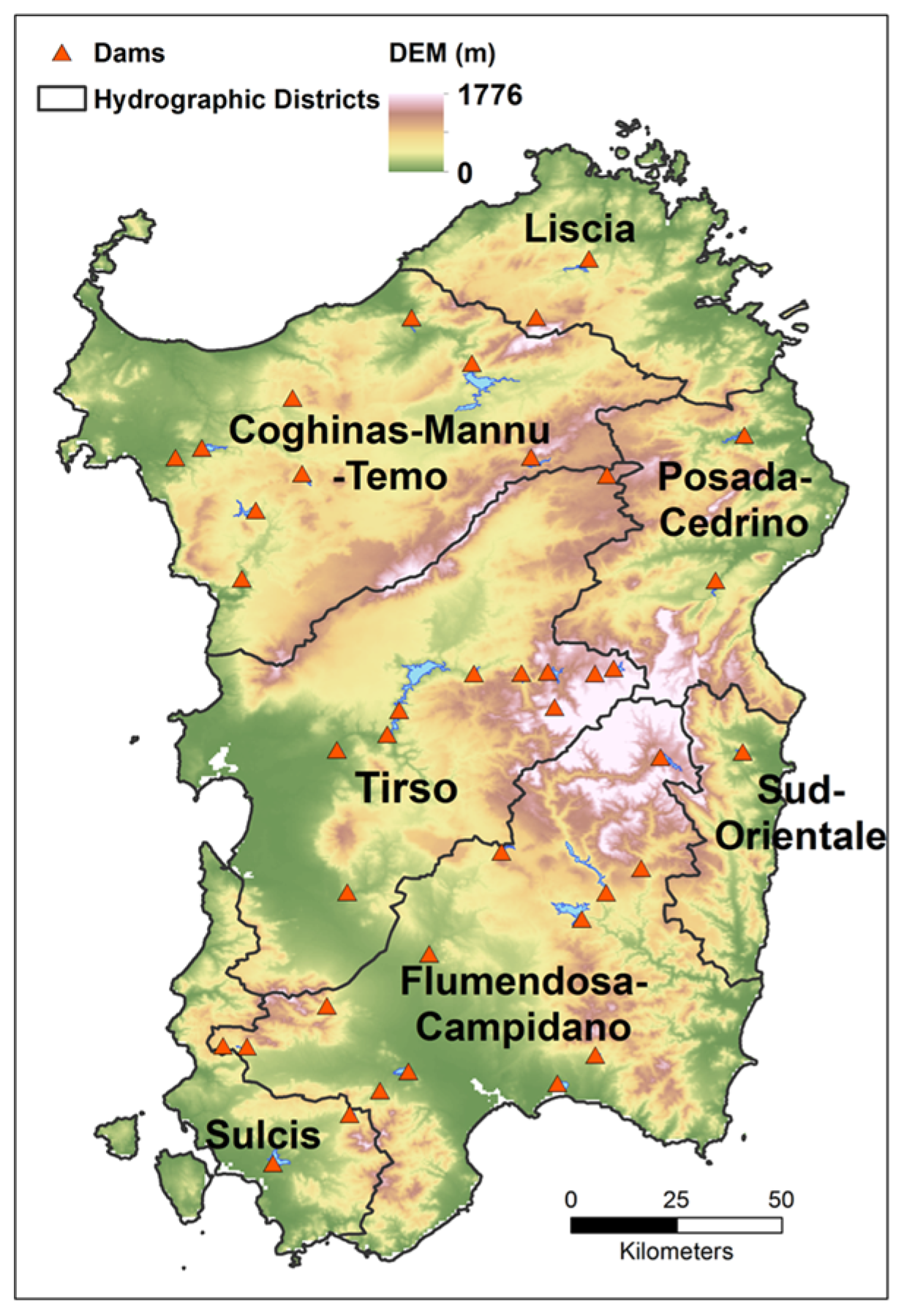
Sardinia (
Figure 1) is located at the centre of the Mediterranean Sea. It has an area of 24,090 km
2 subdivided into plains (14%), hills (68%) and mountains (18%). The total resident population is 1.6 million, 34% of which is concentrated in Cagliari, the capital of the island. The climate is typical Mediterranean, with annual precipitation of 600 ± 400 mm/year, mostly concentrated between October and March. The economy is structured among different sectors, with tourism accounting for about 17% of Gross Domestic Product (GDP) and agriculture for 4%. Water requirements rely on the numerous storage reservoirs (57% of annual demands), and on spring water or groundwater (43%). It has been estimated that the available water resources are only able to satisfy 53% of the regional demand. Agricultural land accounts for about 47% of the total area of the island, but only 7% of this area is currently irrigated, using about 270 million m
3/year of water. Irrigation accounts for 69.4% of the regional water consumption, whereas urban absorbs 25.4% and Industry only 5.2% as many industries have de-salinization plants. Tourist flows (38 million overnight stays were estimated in 2007) correspond to annual water demands of about 9 million m
3, with marked seasonal peaks in coastal areas. The development of the agricultural, tourism and energy sectors under climate change scenarios pose potential threats related to water security, which may imply reduced water availability for irrigation and urban uses. The region is divided in seven hydrological districts (
Figure 1), encompassing different reservoirs and water distribution systems only partially connected between districts. Thus water availability, but also water demand varies spatially in the region (as well as the distribution by sector).
3. Nexus Conceptual Framework
To articulate the conceptual framing of the Sardinia case, interactive workshops with local experts and stakeholders, including academics, public authorities, decision makers and unions, were carried out to define the key nexus sectors to consider, identify sector drivers, relevant key policies, and crucially, how sectors and policies interact.
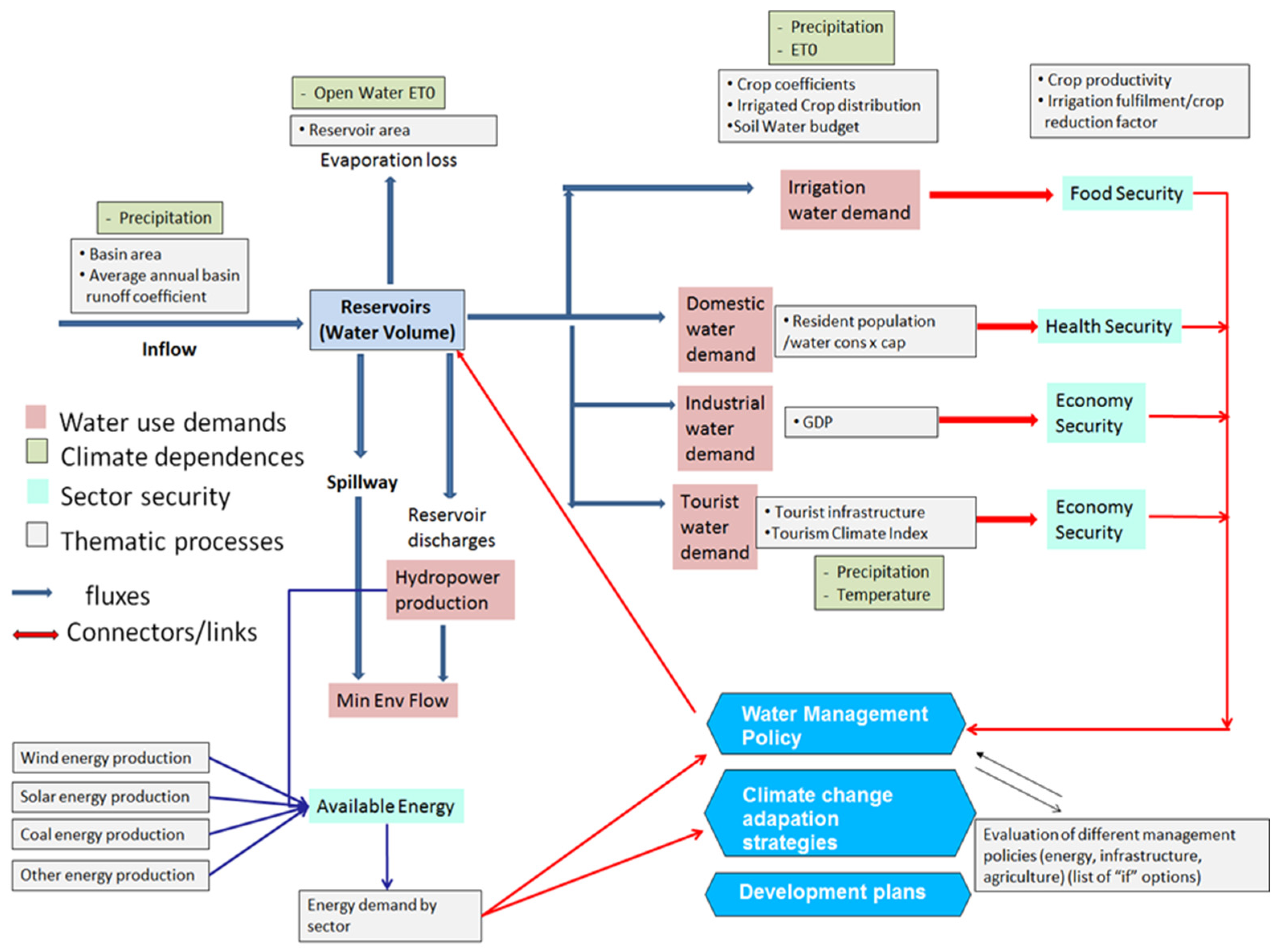
Figure 2 shows the conceptual system diagram developed for the Sardinia, on which further quantitative model development was based. For the Sardinia case study, the main focus in the Nexus was the representation of the reservoir water balance for the island, accounting predominantly for water supply and for water demand related to agricultural, energy-related, and domestic/tourist consumption. While water is the central focus, energy generation and consumption were also important along with the energy source and sector of consumption, together with other aspects regarding climate, tourism, food and land use. In order to implement and analyze the effects of policy changes (e.g., changes in energy mix or changes in cropping patterns) within the Nexus frame, specific coefficients or dynamic variable equations can be altered to reflect changes in policy rules.
On the water supply side, the model accounts for inflows to the reservoirs based on precipitation partitioning to runoff (i.e., runoff coefficients) over the catchment area upstream of reservoirs. For the purposes of the fast track, water supply for the 40 main reservoirs and water demands from specific sectors were aggregated at island level. However, final case study results will aim at a more articulated disaggregation within the seven main hydrological districts in Sardinia. For water demand, the model considers: (1) open-water evaporation from reservoir surfaces; (2) discharges for hydroelectric generation; (3) spillways in times of overflow; (4) irrigation requirements; (5) industrial water demand (dependent on its GDP); (6) domestic and tourist water requirements and; (7) environmental flows (i.e., the minimum amount of water needed to preserve ecological functions and values in watercourses). With irrigated agriculture being the largest water consumer, this sector was modelled in more detail. The crop water requirements per unit-area, and the area planted, were taken into consideration for 13 major crops on Sardinia as a function of current and changing climatic conditions using the SIMETAW-GIS crop water model [
7].
Energy production is modelled from sources including oil and gas, solar, wind and hydropower, while energy demand are evaluated for the agricultural, domestic and industrial sectors. Touristic fluxes, and relative water demands, are modelled based on a Touristic Climate Index [
8] and socio-economic scenarios. Climate change will have an impact on evaporation rates, crop water requirements, precipitation recharge to reservoirs, but also touristic fluxes.
Based on the above conceptualization, it was possible to identify the relevant ‘thematic models’ from within SIM4NEXUS from which derive needed data on present and projected future trends:
CAPRI (a global agricultural and production model; [
9]) for irrigated area by crop
E3ME (a global economic and energy model; [
10]) for energy production and demand by sector
ISIMIP [
11] for downscaled climate data
All other data are from local Sardinian sources, as well as locally relevant data (e.g., for reservoir operating rules and environmental flow regulations).
The model for Sardinia runs simulations for 2010 (the baseline) up to 2050 under RCP climate scenarios 4.5 and 8.5 [
12] and SSP2. The model has a total of 73 variables accounting for each nexus sector and the interlinkages between the sectors. The variables of concern were chosen by the case in consultation with local stakeholders. The modelling time-step is monthly, with all data scaled to this resolution. The model for Sardinia runs with five different climate models, accounting for inter-model variability. The conceptual framework will be further elaborated and improved during the SIM4NEXUS project, although the present framework already gives a reasonably accurate representation of the nexus in Sardinia.
4. Preliminary Results
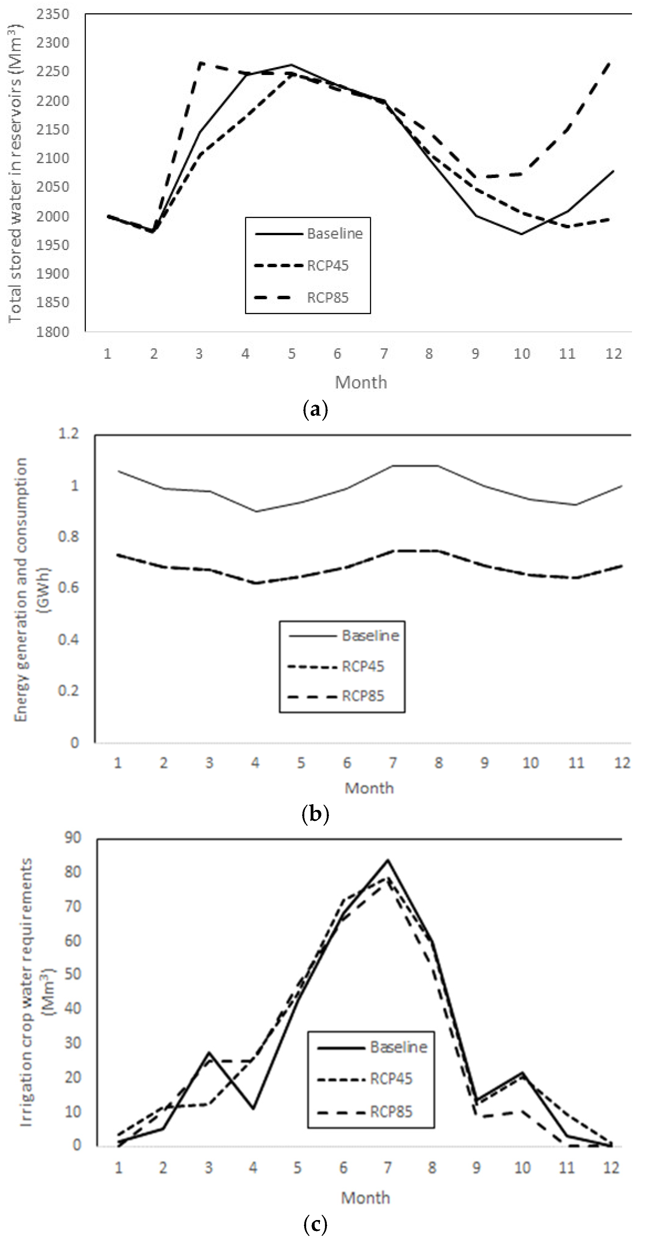
Some preliminary results of simulations of the Water-Energy-Food Nexus for are shown, comparing conditions for 2010 (baseline) and 2030 under both RCP4.5 and 8.5. Since the whole reservoir system in Sardinia was represented in preliminary simulations for simplicity as an aggregated system (i.e., geographically lumped), efficiency to store and redistribute water across the island is overestimates, together with resilience in water supply to climate changes and capacity to match demand (in Mm3 month-1). Anyhow, simulations at aggregated levels did match reservoir patterns of filling and emptying through the year (
Figure 3a) similarly to the real system, and it captured how both energy supplies and demand are matched throughout the year (
Figure 3b).
Energy generation is predicted to be reduced by about 20% in 2030. This is largely due to a reduction in fossil-based energy generation, which is not fully replaced by greener energy sources. Generation is still expected to match consumption every month, but increasing pressure from the tourist sector, especially in the summer months, could strain the system. It could be expected that the replacement to a greener energy system may take long than planned if system strain becomes too large. Also the aggregated water demand for modelled baseline and future irrigation crop water requirements are represented (
Figure 3c). The irrigation requirements are quite similar between present and future in terms of the summer peak, however the annual totals are slightly higher under the RCPs due to the increase in requirement in the spring months. While irrigation requirements might increase in the future (i.e., 2030 over 2010) during spring, they may similarly decreases over fall, mostly due to changes in seasonal precipitation patterns. It is expected that these changes will be further exacerbated by 2050, increasing pressure on the water system, and on the energy system for increasing pumping.
5. Lessons Learnt So Far
Deciding on appropriate levels of model spatial disaggregation is important in producing reliable model outputs and might depend on spatial variability of different physical and socio-economic conditions, where especially the latest are highlighted from local expert stakeholders. This has significant implications for any subsequent analysis and potential policy recommendations. When the whole reservoir system in Sardinia was represented as a unique geographically lumped aggregated system, efficiency to store and redistribute water across the island is overestimates. To represent more closely effective resilience in water supply to climate changes and capacity to match demand, the final SIM4NEXUS Sardinia model development will be disaggregated into seven hydrological basins so as to better reflect spatial variability and to better capture hydrological dynamics across the island. Aggregation for the whole island takes place afterward. A correct spatial representation shows results more accurately expressing on-the-ground situations generating more accurate knowledge for policy and decision making. While considering aggregated analyses with a lumped approach, model results and criticalities for nexus sectors would not have been representative. This consideration has been critically understood and influenced model development in other SIM4NEXUS cases (e.g., Andalucía, Greece, south-west England).
Collaborative and constructive stakeholder involvement, along with relevant and detailed policy analysis, is deeply important in critical development of meaningful Nexus models and must be well thought through and implemented from early stages. During the development of the Sardinia Nexus conceptual scheme, a number of different stakeholders were involved at different stages in the process. Bringing together individuals with different experience, integrating their knowledge and focusing discussions around interactions between different sectors is important, but also time and resource consuming. Several difficulties emerged during stakeholder interactions to expanding the experience of individuals beyond their specific sectors (i.e., breaking ‘silo thinking’). To overcome these difficulties start and find a balanced compromise across sectors includes bringing together stakeholders in cooperative forums. A wide range of relevant but diverse stakeholders have been brought together to determine: (i) the important case-study nexus sectors based on locally-relevant policy issues; (ii) critical interactions between nexus sectors; (iii) data availability; (iv) the main policy-relevant formulations that the model should try to include. Policy analysis for the case study is central in guiding case study development, another element which can easily be neglected.

 ,
, 


