UAVs in Context: Archaeological Airborne Recording in a National Body of Survey and Record
by
 ,
,
David C. Cowley
1,* ,
,
Charles Moriarty
2,
George Geddes
1,
Georgina L. Brown
1,
Tom Wade
2 and
Caroline J. Nichol
2 1
Historic Environment Scotland, John Sinclair House, 16 Bernard Terrace, Edinburgh EH9 9NX, UK
2
School of GeoSciences, Crew Building, University of Edinburgh, Alexander Crum Brown Road, Edinburgh EH9 3FF, UK
*
Author to whom correspondence should be addressed.
Drones 2018, 2(1), 2; https://doi.org/10.3390/drones2010002
Submission received: 30 November 2017
/
Revised: 20 December 2017
/
Accepted: 21 December 2017
/
Published: 23 December 2017
(This article belongs to the Special Issue (Re)Defining the Archaeological Use of UAVs)
Abstract
:Historic Environment Scotland (HES) is the lead public body which investigates, promotes and cares for the historic environment in Scotland. It undertakes a range of archaeological airborne work from detailed documentation of individual sites to extensive national programmes of prospection. In undertaking this work HES draws on a variety of aerial platforms to collect imagery, including light aircraft and unmanned aerial vehicles (UAV—used throughout this paper as an umbrella term). In all cases, the archaeological questions at hand are the key driver for choice of methodology and platforms, recognising that different types of survey and documentation demand different responses. Differing strands of aerial work will be briefly described, followed by short case studies that illustrate the range of our activities, concluding with thoughts on the context of UAV work for archaeological applications.
1. Introduction
Early in 2017, Historic Environment Scotland (HES) issued a tender to appoint a Service Provider for the supply of aircraft to the HES aerial survey programme. This specified single- and twin-engine aircraft, suitably maintained and insured for aerial reconnaissance and photographic work over the whole of Scotland, including more remote areas involving a significant sea-crossing. Such aircraft are required to progress a variety of aerial work, from detailed documentation of individual sites to extensive prospection, all with a primary objective of enhancing the National Record of the Historic Environment (NRHE [1]). The tender produced some responses to supply the required aircraft, but the majority of enquiries arising from the tender were from UAV operators. In large part, this is undoubtedly stimulated by business development, but many of the approaches were framed by asking “if we had considered using UAVs in our work”. There was a sense that we should be using UAVs routinely rather than other platforms, and that perhaps we were unaware of just how useful they could be.
While these approaches stemmed partly from a lack of awareness of the HES aerial survey programme, they also resonate with a sense that UAVs may increasingly be seen by some as a panacea for airborne documentation in archaeology. While this paper is in no way intended to undermine the burgeoning utility of UAVs in archaeological survey, it does aim to provide a commentary on the context of UAV deployment in a wider framework of airborne recording by a national body of survey and record. In doing this it aims to emphasise survey objectives, rather than the technology of “doing”, recognising that to do otherwise runs the risk of losing sight of the archaeological imperative and focussing on a technique for the sake of it. This is important because new technologies are often appealing due to perceptions of reduced cost and perceived added value, but their effective assimilation in recording practice is not without challenges. Indeed, Campana begins his recent review of the state-of-the-art and future perspectives for UAVs in archaeology [2] quoting Don Ihde that “all technologies are non-neutral… They are transformational in that they change the quality, field and possibility range of human experience...” [3] (p. 33). This transformational quality can, of course, have both positive and negative outcomes, an issue that can be recognised in the introduction of other “new” technology to archaeology. For example, in the earlier stages of the archaeological applications of Airborne Laser Scanning (ALS), there was a heavy emphasis on the technology, and showcasing advantages and applications (see [4] (pp. 7–10) for a discussion of these issues in ALS), with a danger of uncritical approaches that foregrounded the technology for the sake of the technology. This paper is a contribution to critical reflection on how archaeological survey practice adopts methods and technology, including avoiding the danger of technology driving survey practice at the expense of competent survey design and archaeological questions. This is not to negate the necessity for periods of research and development, but situates technology as part of an approach to understanding and recording. In the context of a national body of survey and record, and following some case studies, this paper will review issues of purpose, multi-scaled approaches to the landscape and impact on survey workflows.
2. The HES Aerial Survey Programme
HES’ aerial survey programme was established in 1976 (originally by the Royal Commission on the Ancient and Historical Monuments of Scotland (RCAHMS), which was merged with Historic Scotland to form HES on 1 October 2015). This was built on a long history of aerial reconnaissance in light aircraft and utilisation of aerial photography for archaeology in Scotland dating back to the 1930s [5,6]. Initially, the focus of aerial reconnaissance was on prospecting for cropmarked sites in lowland areas, while other aerial photographs, such as those taken to inform map revision by the Royal Air Force and Ordnance Survey, were consulted to inform field survey projects. However, the value of the airborne perspective for recording and understanding all aspects of Scotland’s historic environment was quickly recognised and the scope expanded to take in architectural subjects and urban areas, though in this paper we focus on archaeological monuments and landscapes. The light aircraft based aerial work that has been practiced for the last 40 years extends across the whole of Scotland’s 80,077 km² land mass, in an average year undertaking over 100 flying hours (Figure 1).
This aerial survey programme has made two principal contributions to archaeological knowledge in Scotland. Firstly, reconnaissance has placed many thousands of previously unknown monuments on record for the first time, and secondly recording of known monuments provides additional sources for analysis and understanding, informs assessment of monument condition, on which an increasing emphasis is being placed, or provides illustrations [7]. For archaeological prospection, while the early emphasis of reconnaissance was on recording cropmarking in lowland areas [8], this expanded to exploring upland areas for earthwork remains [9] and the coast and shallow water for marine features [10]. The importance of the traditional observer-directed reconnaissance and visible spectrum photography cannot be understated, but critical review of diminishing returns from this approach [11] and developments in other data sources has prompted a change in emphasis, coincident with increasing availability of digital topographic data produced by airborne laser scanning [12] or from aerial photographs, active exploration of multi- and hyperspectral imaging [13], and more speculative investigation of synthetic aperture radar [14]. In all cases, the core objectives of this range of technological research and development activity is to support our prime archaeological objectives of:
- improving our knowledge base in the NHRE through the discovery of previously unknown sites
- improving our knowledge base through archaeological analysis of sites and landscape
- understanding landscape changes
- assessing the impact of climate and coastal changes on the historic environment
- informing understanding of the condition and management of sites
- improving the efficiency of survey methodology
Until 2015, our aerial recording of archaeological remains in Scotland’s historic environment was progressed almost entirely using Cessna 172 light aircraft. This included some experimentation with image-based modelling and also made use of an extensive archive of historic aerial imagery and orthophotographs. Since then we have developed an in-house UAV platform for photography, worked with contractors to produce higher-end imagery to generate metrically accurate high-resolution point clouds and derived products, and progressed our interest in multispectral imagery through a UAV-based Masters dissertation project. These are discussed in case studies that follow a brief section outlining aspects of our development of UAV capacity and applications.
3. The Development of Archaeological UAV-Based Capacity and Recording at HES
While architectural colleagues within HES had already acquired UAV capacity some years ago, mainly to inform condition monitoring of buildings, the desire to expand this capability into archaeological applications was an obvious development. In 2015, we had no in-house archaeological UAV capability and only informal expertise of flying UAVs amongst staff. This prompted a review of options to assess the range of survey functions that could use UAV recording, including seeking an improved understanding of practicalities and issues such as operational and legal frameworks and insurance requirements. For archaeological field survey, we recognised the desirability of collecting low altitude aerial imagery to complement the more general views provided by light aircraft aerial photography, usually captured from 700 m altitude, and photography from the ground. A low altitude platform would also allow us to experiment with video documentation, which is generally unsatisfactory from a light aircraft where dramatic perspectives are hard to generate. Furthermore, building on our interest in digital topographic data, this would support further exploration of the utility of high resolution imagery (sub-metre to centimetre-scale) and image-based modelling to support the generation of point clouds, orthophotographs and other derived products.
The review of options to address these archaeological imperatives highlighted the tremendous range of UAV equipment and range of capabilities, and the consequent variation in complexity of operation and costs (Table 1).
The review also highlighted the need for any operation to be fully compliant with aviation regulations and health and safety provisions, to be covered by comprehensive insurance and aware of privacy issues. We also consulted external organisations with more experience in using UAVs in archaeological recording, and the consistent advice was that it would be risky to purchase an expensive UAV without first experimenting using contractors. The appraisal produced two recommendations, balancing the desirability of having in-house capacity and the need to experiment with high-end products. Firstly, we should start to develop in-house UAV capability in support of archaeological fieldwork, whereby staff familiar with sites and landscapes could capture images that served their objectives best (Case Study 1). Secondly, that we buy in services from specialist companies with the required expertise and equipment when high end products or technical operations are sought (Case Study 2). In a third strand that emerged subsequently, recognising the benefits of working with specialists, we have collaborated with the Airborne Geosciences Facility within the School of GeoSciences at the University of Edinburgh on a project using a UAV-mounted multispectral sensor (Case Study 3).
4. Case Study 1: UAV Documentation and Photography in Archaeological Field Survey
The most widespread application of UAVs in archaeology to date is in the routine capture of digital still photographs and video, generally of sites, but also of discrete landscapes. This is certainly the case within archaeological survey at HES, where UAV-based documentation is increasingly seen as a standard, versatile and cost-effective element of the toolkit brought to bear during archaeological field recording projects.
4.1. Developing HES Archaeological UAV Operations
Developing our UAV capacity required a series of issues to be addressed, including perceptions that the processes of gaining adequate experience, training as a pilot, and obtaining the necessary permissions and insurance are difficult. In practice, the skills of UAV piloting are achievable by anyone with reasonable dexterity and eye/hand coordination, but they require practice in a variety of terrains and weather conditions to achieve and maintain proficiency. While software and hardware are becoming more sophisticated, there remains an imperative for the pilot to understand the fundamentals of aviation, to be able to operate without the aid of the camera view, and in particular to be able to respond to a variety of emergencies.
4.2. Legal and Operational Frameworks
All UAV flights undertaken by HES Survey and Recording are governed by an Operations Manual detailing the framework within which we operate. Flights are undertaken for the sole purpose of survey and recording of the built environment and are regarded as non-commercial. We operate within the framework of the Air Navigation Order [15] published by the UK Civil Aviation Authority, specifically within the terms for non-commercial work defined in CAP 722 [16] (p. 34) whereby “Flying operations such as research or development flights conducted ‘in house’ are not normally considered as aerial work provided there is no valuable consideration given or promised in relation to each flight”. The Operations Manual mandates that every pilot will be conversant with the current ANO, the Air Navigation (General) Regulations and the Rules of the Air, and Air Traffic Control Regulations and will at all times comply with their requirements. HES has also ensured appropriate insurance and public liability cover is in place and takes a careful approach to the mitigation of risk. Beyond this general framework HES operations apply the fundamental rules of UAV operation sensibly expressed in the “Drone Code” [17], that the pilot should try to keep the UAV within sight, stay below 120 m in height above the pilot and 150 m from people and property.
4.3. UAVs in HES Field Survey
As highlighted above, there has been a growing recognition of the value of UAV recording as an element of routine archaeological survey, providing detailed, low altitude perspectives and video as required. At the time of writing (November 2017) HES archaeological field survey uses a DJI Phantom 4 Pro + UAV which cost under £2000, and has a flight time of up to 30 min depending on payload and a high degree of safety and automation in operation, benefits that have been balanced against the size and quality of the captured images from the onboard camera. However, while it is anticipated that this capacity will continue to be developed, at present this provides significant added value to the field survey process. Perhaps the most obvious advantage that a UAV offers the field surveyor is access to difficult to reach places. With a regulated limit of 400 m distance from the operator (which can be extended in special circumstances), an expectation to maintain line of sight, and a height limit of 120 m, there is scope to fly over sea stacks and island sites, or to examine the upper floors of a ruinous building—allowing inaccessible monuments to be documented and mitigating risk (Figure 2).
More generally, illustrative material has a fundamental role in the creation of information on archaeological sites within the NRHE [2], aiding the identification of specific monuments and helping to illustrate descriptive text. In this respect UAV imagery can be particularly powerful, falling as it does between the range of the ground photographer and that of the traditional higher altitude aerial photographer (Figure 3). Since field teams are often on site in remote areas for several days at a time, they are in an ideal position to catch the best light conditions to enhance photographic output. In addition to oblique imagery, video can further enhance site documentation, providing dramatic perspectives and detail. Embedding UAV capacity in field teams provides a flexible aerial platform which fieldworkers engaged in a landscape or site survey can use to capture imagery within minutes of the lighting and weather conditions being appropriate and to document specific aspects of the monument. In this context, the application of UAV documentation in HES archaeological survey has significant benefits for the engagement of the archaeologist with a site or landscape, helping to address interpretational challenges or illustrating particular conclusions. Here, the UAV is used to support the engagement of a field archaeologist with a site and to create illustrative components of the site record. This is counter to some statements that uncritically advocate use of UAV documentation to minimise time on site [19].
Indeed, in this context field surveyors are aware of the dangers that incorporating a UAV in field survey might distract from field investigation and observation of the material remains, as the pilot is inevitably taken up with the UAV operation. Thus, there is the potential to leave a site with beautiful images but to move no further forward in archaeological interpretation. This takes us back to the primary imperatives of the work being undertaken, to advance archaeological understanding, rather than simply producing pretty pictures, which would be documentation for the sake of documentation rather than in support of understanding. This is a point that will be returned to below with reference to the collection of photographs for image-based modelling, where there is a danger of the archaeologist’s engagement with the site or landscape being limited to the task of photo collection, without further engagement with the landscape or surface remains. That said, a well-composed image has a major role to play in conveying context and setting (Figure 4).
5. Case Study 2: Generating Topographic Outputs
HES had already undertaken limited experimentation producing digital topographic outputs and orthophotographs using image-based modelling (Agisoft PhotoScan) with images taken from a light aircraft. However, with an increasing interest in high resolution and positionally accurate 3D data sets, our review of potential UAV applications included a recommendation that requirements for high quality UAV imagery for use in image-based modelling outputs to inform detailed site analysis should be progressed through an experienced specialist contractor. While it was recognised that the contractor approach to imagery collection was not as flexible as an in-house solution, nor did it embed the development of capacity and expertise in the organisation, it provided a cost-effective way to explore the potential of this approach to produce high resolution topographic outputs and orthophotos, since there was no outlay for equipment, nor any issues with developing competence in handling it.
In developing this work, we issued a tender for two recording projects in late 2015, specifying a requirement for a CAA certificated operator to capture a grid of high quality overlapping vertical photographs, and for oblique imagery and videos to be taken to accompany this data. Furthermore, the contractor was required to provide accurate GPS-mapped ground control points. Following open competition, the package of work was put out to Cyberhawk, a company based in Central Scotland with easy access to project sites, which meant that they were able to respond quickly to appropriate weather conditions. The two-person Cyberhawk team, both of whom were trained in the use of the equipment and operated it full time, used a UAV system which cost approximately £25,000 (November 2015) in a contract that was worth a little over £4000. This offered a stable platform for the work, reasonable flight times and pre-programmed flight paths, and the capacity to deploy a Sony A7 digital camera for image capture (CMOS Sensor, effective megapixels 24.3).
At both sites chosen for this exercise there was a central archaeological imperative to explore how high-resolution digital topographic data would support the archaeological understanding of the remains, which are explored here through the example at Hume Castle, Scottish Borders (Figure 5). This comprised an area of 500 m by 380 m within which there are the earthworks of a deserted medieval village and cultivation remains set around a rocky knoll on which the fragmentary remains of a medieval castle are built over by a stone walled “castle” folly. There are a small number of large trees on the site, which is situated beside a few houses along a single track road. At Hume, a ground sampling distance (GSD) of 3 cm was specified. In both cases, the photographic outputs were excellent, supporting the production of dense point clouds and a high-resolution orthphotograph, and derivatives that supported further archaeological analysis.
The Hume Survey
The site at Hume has been worked on in an iterative survey methodology combining desk and field-based work to support an intensive engagement with the archaeological remains. The workflow following the UAV imaging of the site in March 2015, when vegetation was low, is straightforward. The imagery was processed using Agisoft Photscan software and accurately-mapped ground control points to produce a dense point cloud and an orthophotograph. DSMs on a 10 cm and 25 cm grid were produced and these were visualised using the Relief Visualisation Toolbox software [22] to create visualisations, including slope, hill shades and Sky View Factor (SVF). Following desk-based assessment of the models and visualisations, Multi Directional Hillshade and SVF visualisations derived from the 25 cm grid were printed out at a scale of 1:1000 and taken into the field. A field team of three then explored the site using the visualisations and the printouts in an iterative way, returning from the field with annotated printouts. The field outputs were digitised and refined in the office, here with the benefit of examining a wider range of visualisations to explore some of the finer detail. Additional features identified in the desk-based stage were examined on a subsequent visit.
At the time, we did not have a pen computer capable of supporting visualisations in the field, and clearly that would have been a benefit. However, we do not believe that this benefit is uncomplicated, as the simplicity of the printouts helped avoid the distraction from field observation caused by trying to articulate too much data in the field. However, even the two printed visualisations were very useful in the field, especially for subtle features on the ground, when working in flat light conditions, and also after the vegetation started growing. More generally, the multi-scalar character of the digital data was important in combining detail and context in tracing slight, often discontinuous features. Both field observation and observation of the visualisations provided the lead, depending on circumstances. For example, a section of tower footing from the earlier castle, situated at the top of a virtually inaccessible rock outcrop, was spotted on site and subsequently the extent of the whole feature was mapped from the model, also making use of the oblique aerial photographs. In contrast, an early phase of ridge and furrow overlain by later ridging stood out very clearly on the visualisations but remained impossible to spot on the ground. In this way, the digital topographic outputs and field observation were managed in concert to explore the site and maximise our understanding. In practice, while the workflow varied from a traditional field survey approach, the amount of time spent on the project overall was probably broadly similar. The digital approach has, however, also provided a record of the site that can be assessed in future in considerable detail, for example to quantify changing condition.
Amongst the lessons learned from the Hume exercise is that with the high cost of the equipment needed to produce the photographs at the time, the contractor route was cost-effective and provided a benchmark against which future work could be judged. However, recognising that the technology is changing rapidly and that our requirements for such outputs may increase, there is an ongoing cost-benefit that will need regular review. The project has also focused our minds on the data storage implications of such projects, and the need for a rationale behind what is kept and what is not. For example, while the point cloud, orthophotographs and DSMs are being kept for the archive, there has been some debate about whether the source photographs and the derived visualisations should be archived. The Hume project folders contain 150 GB of data for just one site, and as this approach becomes more routine the implications for storage budgets will multiply rapidly.
6. Case Study 3: Multispectral Imaging Research Project
The diminishing returns from traditional cropmark reconnaissance using visible spectrum imaging have been commented on above. This situation has prompted a programme of research and development to explore the potential of hyper- and multispectral imaging, recognising the potential of this data to provide new information [23,24]. This has included purchasing satellite imagery, but this is expensive, and crucially it is difficult to specify the appropriate conditions under which the best archaeological returns can be expected. For this reason, in 2017, a UAV-based multispectral imaging project [25] was undertaken in collaboration with the University of Edinburgh’s School of GeoSciences. The central objective of this project was to collect multispectral data over an archaeological site at regular intervals to gain an understanding of when it is best to detect buried archaeological remains through its impact on the crop above it. Using a well-known set of archaeological features in a field in central Fife, that had been documented as visible spectrum cropmarking over many years, the project aimed to collect multi-temporal imaging throughout one growing season using a UAV platform carrying a lightweight, low-cost Parrot Sequoia sensor (Figure 6).
The Parrot Sequoia [26] is a four-band multispectral sensor designed to capture high-resolution images across vegetation-sensitive wavelength bands (Table 2), and was deployed on a series of UAV-mounted observations at the test site between April and July 2017. During the same period, the field was documented from a light aircraft using a Nikon D800E digital camera. From the two image sets, the project aimed to identify the capabilities and timing for detecting crop stress from Parrot Sequoia imagery in comparison to RGB photography, with implications for the wider adoption of multispectral imaging in efficient archaeological reconnaissance and documentation.
6.1. Ravenshall, Fife: Data, Collection and Processing
The test site at Ravenshall [27] is an arable field 5.5 ha in extent, where there are well-documented features including a possible henge monument and land-use remains that have been documented over many years as cropmarking. The field was set to winter wheat (Triticum aestivum), and, while it had been hoped to conduct a larger number of UAV data collections, technical and weather issues meant that only three surveys were conducted—on 17 April, 5 May and 12 July. Surveys were flown using the open-source Mission Planner autopilot software [28] at an altitude of 60 m, velocity of 4 ms−1 and calculated image overlap of 70%. This allowed the field extent to be covered in two flights with an average GSD of approximately 6.00 cm/pixel for the multispectral images. Illumination conditions at the time of flight were recorded by a separate “Sunshine” sensor attached to the top of the UAV, and encoded within the multispectral camera image files for radiometric calibration. Calibrated MicaSense reflectance panels were photographed before and after each flight to further support radiometric correction during processing. A series of fixed checkerboard ground control points (GCPs), constructed from vinyl tiles (Figure 6), were installed around the perimeter of the field and measured to 0.5–3.5 cm accuracy using a Trimble differential global navigation satellite system (GNSS) kit.
The georeferenced .tiff Sequoia files were processed using Pix4Dmapper Pro (Version 3.1.23.0), which has native support for the Sequoia sensor, to build Digital Surface Models (DSMs) and orthomosaics. Pix4D was also used for radiometric calibration of the Sequoia data, using the Sunshine sensor data and calibration panel images to normalise images and attempt to correct for atmospheric effects [29].
6.2. Processing and Analysis
The orthomosaics created for each multispectral band were combined in several different ways to test the ability to distinguish cropmarking within the data, including stacked multiband images that allowed for false colour composite visualisation, principal component transforms and the calculation of sixteen vegetation index (VI) maps. From historic reference photographs and pre-existing interpreted mapping undertaken by HES, two sample regions were defined: “object”, across areas of archaeological interest and “field”, across adjacent regions of the surrounding field and equivalent in area. Values found for these regions in the different band combinations were tested for histogram separability, which gave an indication of the ability to distinguish the two samples across each visualisation method over time. This allowed examination of when the two samples began to change relative to one another.
Crop stress influenced by the presence of archaeological features was successfully detected utilising the Parrot multispectral imagery at equivalent timings to the RGB imagery. The 17 April and 5 May data showed little separation across individual bands and band combinations in the two sample regions during the early stages of crop growth. However, on 12 July, these regions had changed at different rates, showing greater histogram separability across several different band combinations. Archaeological cropmarking was detected in the RGB aerial photographs visually from 14 June onwards, with an increase in separability found following the period of highest regional soil moisture deficits for the 40 km square in which the test site is located (Figure 7). The multispectral orthomosaics from the Parrot Sequoia had similar resolutions and accuracies to those created from the higher altitude digital camera photographs (6–7 cm/pixel; 0.1–0.2 m mean RMS x-y-z error), yet the narrow and calibrated spectral bands of the Sequoia resulted in images with finer detail of subtle changes across the crops, which has positive implications for being able to detect a potentially wider range of features using the sensor (Figure 8).
6.3. Lessons Learned and Next Steps
As had originally been planned, comparison with other sensor types such as a hyperspectral sensor offering finer spectral resolution would be beneficial in determining the comparative efficiency of the Sequoia. Use of the Sequoia for larger-area survey is constrained by the battery life of the UAV, weather conditions, availability of accurately measured GCPs, and the constraints on pilot to UAV distance. However, as a flexible and cost-effective means of collecting multi-temporal data on test sites, notwithstanding the technical and weather issues encountered, it has proven valuable.
7. Discussion
The case studies presented above are examples of the deployment of UAV platforms within a national programme of archaeological survey. Although the deployment of the new Parrot Sequoia sensor, in this case for archaeological purpose, is to our knowledge a first, the case studies foreground the archaeological imperatives for HES Survey and Recording. Specifically, the UAV platform is used to support deeper understandings of the past, land-use change, and issues such as changing condition and climate.
This paper began by acknowledging that new technology has a transformative power, and that this can carry both negative and positive connotations. In this context, we have noted that the enthusiasm for UAV deployment in archaeology has produced some applications with little obvious archaeological outputs—that place documentation for the sake of documentation above understanding and interpretation. Indeed, outputs such as 3D models embedded in PDFs and perspective views or surface models with no associated archaeological interpretation are common, creating an impression that the model, or the surface model, is a sufficient primary output. These approaches also often gloss over the errors associated with the 3D modelling process, which may skew archaeological interpretation of the outputs. While the proliferation of UAVs is undoubtedly democratising access to 3D data, this is actually a broader issue in archaeological engagement with topographic data, including ALS, rather than a specifically UAV issue.
There are also implications for workflows, and deployment of UAVs in archaeological documentation is sometimes presented as a means of speeding up the recording process—with consequent implications for spending less time engaging with the material remains. For HES, field survey has taken a flexible approach to UAV deployment, for example (Case Study 1) using such imagery as part of the toolkit in site and landscape survey, all the time maintaining an archaeological imperative. In Case Study 2 we discussed how the UAV photography and image-based modelling was used in support of an intensive engagement with the material remains in the field, in an iterative process combining data processing, visualisations, desk-based analysis and field observation to improve archaeological knowledge about the site or landscape. While image-based processing and derivatives of the outputs may provide very powerful perspectives that inform different engagements with the remains, and may provide time efficiencies in survey, we are wary of a position that uncritically promotes “time saved in the field” as a benefit of UAV deployment. This is because the question of how different approaches to knowledge-creation should be deployed, whether from desk-based analysis or field observation or combinations of methods, depends on the archaeological questions being asked, and these should not be primarily driven by a technological or methodological preference. The key question is how our survey methodology or source data improves our understanding of specific research questions, not how a technological development may effect a change in working practice (though that should happen).
This also relates to scale of survey, and the potential problems of “landscapes” being defined essentially by line of sight when UAV imaging is the primary source of aerial documentation. That is why our “national” programme of aerial reconnaissance and photography remains an important element of our airborne capacity. A three-hour flight in a light aircraft may cover a large area, or document 70 monuments, with imagery that has a 5 cm to 10 cm GSD depending on camera characteristics (Figure 1). Creating equivalent coverage using a UAV would require a single set up per site, taking many days or weeks of work, and UAVs at 120 m above ground level are simply not capable of capturing imagery of certain sites and landscapes, nor of providing a wide context. This is not a competitive statement, but identifies that there are multiple ways to approach airborne documentation depending on the task at hand, and that uncritical attachment to a particular “flavour of the month” is unwise because it foregrounds technology over purpose at hand. Thus, while UAV deployment has been promoted as a means of removing the observer bias inherent in observer-directed aerial reconnaissance, this is in fact not an issue of UAV use, but of survey design that demands area coverage rather than observer-directed image collection, and this can be achieved using UAVs or light aircraft. Having said that, and as demonstrated in Case Study 3 on multispectral data collection, the flexibility and cost-effectiveness of a UAV platform in choosing intervals and timing of data collection is a huge advantage over a light aircraft solution, although changeable weather is a continuing challenge.
8. Conclusions
The points raised above are intended to sound a cautionary note in response to some uncritical enthusiasm for UAVs in archaeology (e.g., [19]). While HES applications of UAVs in archaeological survey have been slow in coming, we have sought to embed this capacity in an approach that has archaeological interpretation and understanding at its core. In doing this, we seek to avoid documentation for the sake of documentation alone, and to maintain an approach to airborne recording for archaeological survey that extends from the national to the local, and from the broad brush to the particular.
Acknowledgments
Our thanks to Robin Turner, John Sherriff and Lukasz Banaszek for comments on the text, to our anonymous reviewers for their input, and to Oscar Aldred and Piers Dixon who contributed to aspects of the work reported on here. Thanks are due to Mrs Graham of Raecruick farm who allowed access to their grounds for the multispectral project. Adara Lopez-Lopez helped to prepare the historic aerial photographs for Ravenshall, while Robert Adam contributed to the aerial documentation of the test site throughout the growing season.
Author Contributions
The concept originates with D. Cowley, who wrote the general sections and compiled the paper. Case Study 1 was written by G. Geddes, Case Study 2 by G. Brown and D. Cowley, and Case Study 3 by C. Moriarty. Moriarty was a Masters student at the University of Edinburgh during the project (Case Study 3). C. Nichol assisted with the design of Case Study 3. T. Wade piloted the drone and collected all drone data. Both Nichol and Wade oversaw the handling of the drone data, statistical testing and preparation of the results.
Conflicts of Interest
The authors declare no conflict of interest.
References
- Canmore. Available online: https://canmore.org.uk/ (accessed on 27 November 2017).
- Campana, S. Drones in Archaeology. State-of-the-art and Future Perspectives. Archaeol. Prospect. 2017, 24, 275–296. [Google Scholar] [CrossRef]
- Ihde, D. Postphenomenology: Essays in the Postmodern Context; Northwestern University Press: Evanston, IL, USA, 1993; ISBN 10: 0810112752. [Google Scholar]
- Opitz, R.S.; Cowley, D.C. (Eds.) Interpreting Archaeological Topography: Airborne Laser Scanning, 3D Data and Interpretation; Oxbow: Oxford, UK, 2013; ISBN 9781842175163. [Google Scholar]
- Cowley, D. Creating the cropmark archaeological record in East Lothian, southeast Scotland. In Prehistory without Borders: Prehistoric Archaeology of the Tyne-Forth Region; Crellin, R., Fowler, C., Tipping, R., Eds.; Oxbow: Oxford, UK, 2016; pp. 59–70. ISBN 9781785701993. [Google Scholar]
- Geddes, G. Archaeology at the margins—RCAHMS emergency survey in the 1950s. Proc. Soc. Antiq. Scot. 2013, 143, 363–392. [Google Scholar]
- Cowley, D.; Crawford, J. Above Scotland: The National Collection of Aerial Photography; RCAHMS: Edinburgh, UK, 2009; ISBN 10: 1902419871. [Google Scholar]
- Maxwell, G.S. Recent aerial survey in Scotland. In The Impact of Aerial Reconnaissance on Archaeology; Maxwell, G.S., Ed.; CBA Research Report No 49; Council for British Archaeology: York, UK, 1983; pp. 27–40. [Google Scholar]
- Cowley, D.C. Aerial Reconnaissance and Vertical Photography in Upland Scotland: Integrating the Resources. In Aerial Photography and Archaeology; Bourgeois, J., Meganck, M., Eds.; Academia Press: Ghent, Belgium, 2005; pp. 267–279. [Google Scholar]
- Cowley, D.; Benjamin, J.; Martin, C. Aerial reconnaissance of maritime landscapes in Scotland—Some preliminary observations on context, methodology and results. AARGnews 2012, 45, 64–73. [Google Scholar]
- Cowley, D. Aerial Photography and Reconnaissance for Archaeology in the 21st Century: achievements and challenges. In Proceedings of the 2nd International Conference of Aerial Archaeology, Archeologia Aerea, Rome, Italy, 3–5 February 2016. [Google Scholar]
- Cowley, D.; Lopez-Lopez, A. Developing an approach to national mapping—Preliminary work on Scotland in miniature. AARGnews 2017, 55, 19–25. [Google Scholar]
- Doneus, M.; Verhoeven, G.; Atzberger, C.; Wess, M.; Ruš, M. New ways to extract archaeological information from hyperspectral pixels. J. Archaeol. Sci. 2014, 52, 84–96. [Google Scholar] [CrossRef]
- Tapete, D.; Cigna, F. SAR for Landscape Archaeology. In Sensing the Past. Geotechnologies and the Environment; Masini, N., Soldovieri, F., Eds.; Springer: New York, NY, USA, 2017; pp. 101–116. ISBN 978-3-319-50516-9. [Google Scholar] [CrossRef]
- The Air Navigation Order (ANO) 2016. Available online: https://publicapps.caa.co.uk/modalapplication.aspx?catid=1&pagetype=65&appid=11&mode=detail&id=7523 (accessed on 28 November 2017).
- CAP 722: Unmanned Aircraft System Operations in UK Airspace—Guidance. Available online: https://publicapps.caa.co.uk/modalapplication.aspx?appid=11&mode=detail&id=415 (accessed on 28 November 2017).
- The Drone Code. Available online: http://dronesafe.uk/drone-code/ (accessed on 27 November 2017).
- Canmore. Available online: https://canmore.org.uk/site/10415/north-uist-dun-ban (accessed on 27 November 2017).
- Hanus, K. Mapping the Inhospitable Landscapes of the Orkney Islands using RPAS. Archaeol. Prospect. 2017. [Google Scholar] [CrossRef]
- Canmore. Available online: https://canmore.org.uk/site/22686/eilean-fhianain-st-finnans-chapel (accessed on 27 November 2017).
- Canmore. Available online: https://canmore.org.uk/site/74471/brough-of-birsay-lighthouse; https://www.historicenvironment.scot/visit-a-place/places/brough-of-birsay/history/ (accessed on 27 November 2017).
- Relief Visualization Toolbox (RVT). Available online: https://iaps.zrc-sazu.si/en/rvt#v (accessed on 27 November 2017).
- De Guio, A. Cropping for a better future: Vegetation Indices in Archaeology. In Detecting and Understanding Historic Landscapes; Chavarria Arnau, A., Reynolds, A., Eds.; Sap Societa Archaeologica: Mantua, Italy, 2015; pp. 109–152. ISBN 978-88-87115-99-4. [Google Scholar]
- Doneus, M.; Verhoeven, G.; Atzberger, C.; Wess, M.; Ruš, M. New ways to extract archaeological information from hyperspectral pixels. J. Archaeol. Sci. 2014, 52, 84–96. [Google Scholar] [CrossRef]
- Moriarty, C. Deploying Multispectral Remote Sensing for Multitemporal Analysis of Archaeological Crop Stress at Ravenshall, Fife. Master’s Thesis, School of GeoSciences, University of Edinburgh, Edinburgh, UK, 2017. [Google Scholar]
- Parrot Drones SA. Parrot Sequoia Technical Specifications. Available online: https://www.parrot.com/us/Business-solutions/parrot-sequoia#technicals (accessed on 25 June 2017).
- Canmore. Available online: https://canmore.org.uk/site/29779/ravenshall (accessed on 27 November 2017).
- ArduPilot Dev Team. 2016. Available online: http://ardupilot.org/ (accessed 28 November 2017).
- Pix4D. 2017. Available online: https://pix4d.com/ (accessed 28 November 2017).
Figure 1.
An example of a 2 h 40 min long light aircraft sortie on Shetland, 25 August 2017, with examples of the images captured. The GPS recorded line of the flight is indicated in orange against the grey outline of the Shetland Islands. During this flight, some 560 images were taken of 119 monuments. In an average year, between 4000 and 6500 aerial images are taken from a light aircraft platform, documenting up to 2000 monuments, of which an average of 250 are new discoveries. DP260585, DP260415, DP260512, DP260576, DP260772 © Historic Environment Scotland.
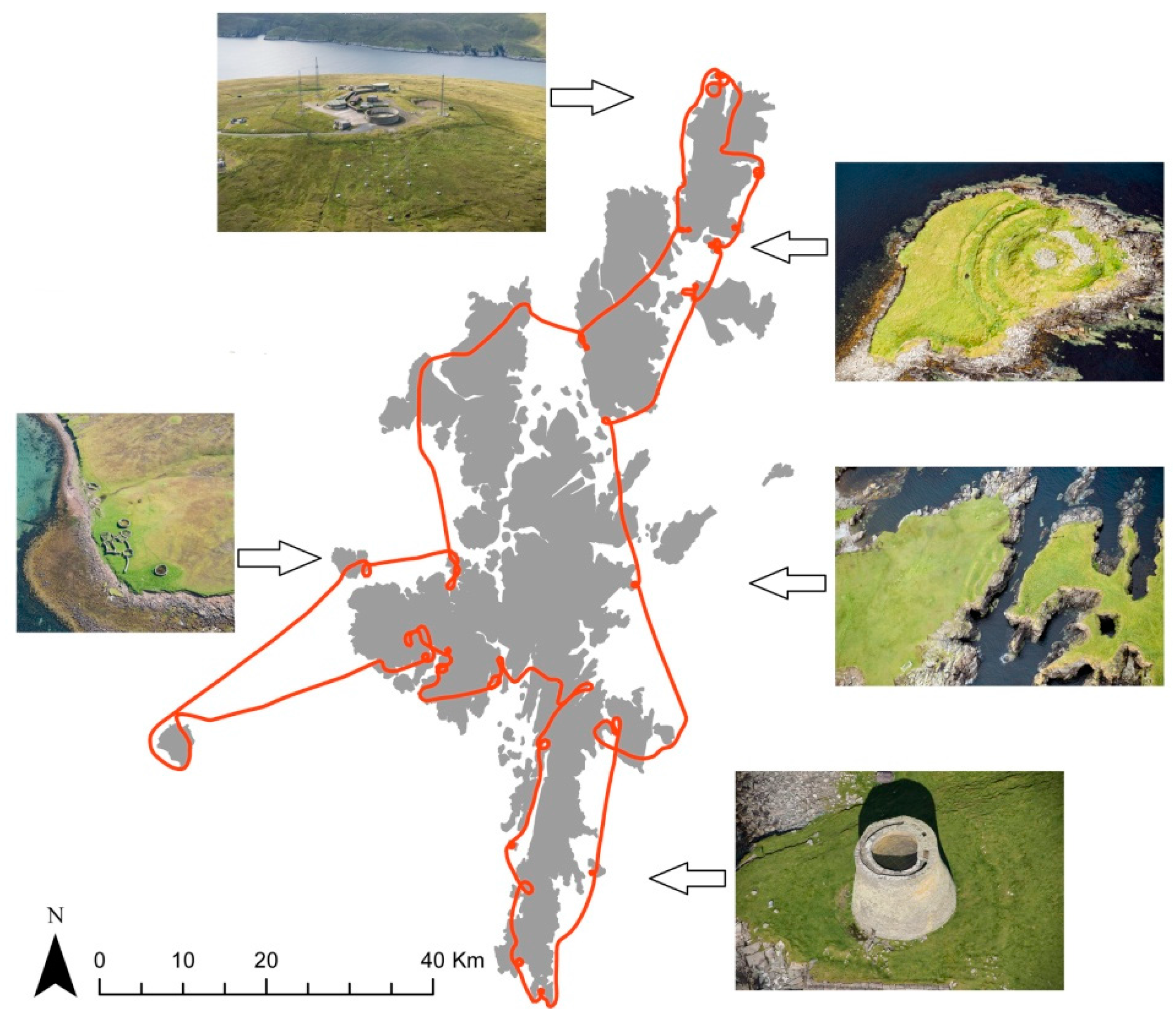
Figure 2.
The later prehistoric site at Dun Ban, Loch Hundair, North Uist [18] is 200 m from the shore of a loch that lies some 3 km from the nearest road. Simple oblique imagery of the site such as this captured from a UAV is relatively easy to acquire and provides information on the character and condition of the monument. DP258284 © Historic Environment Scotland.
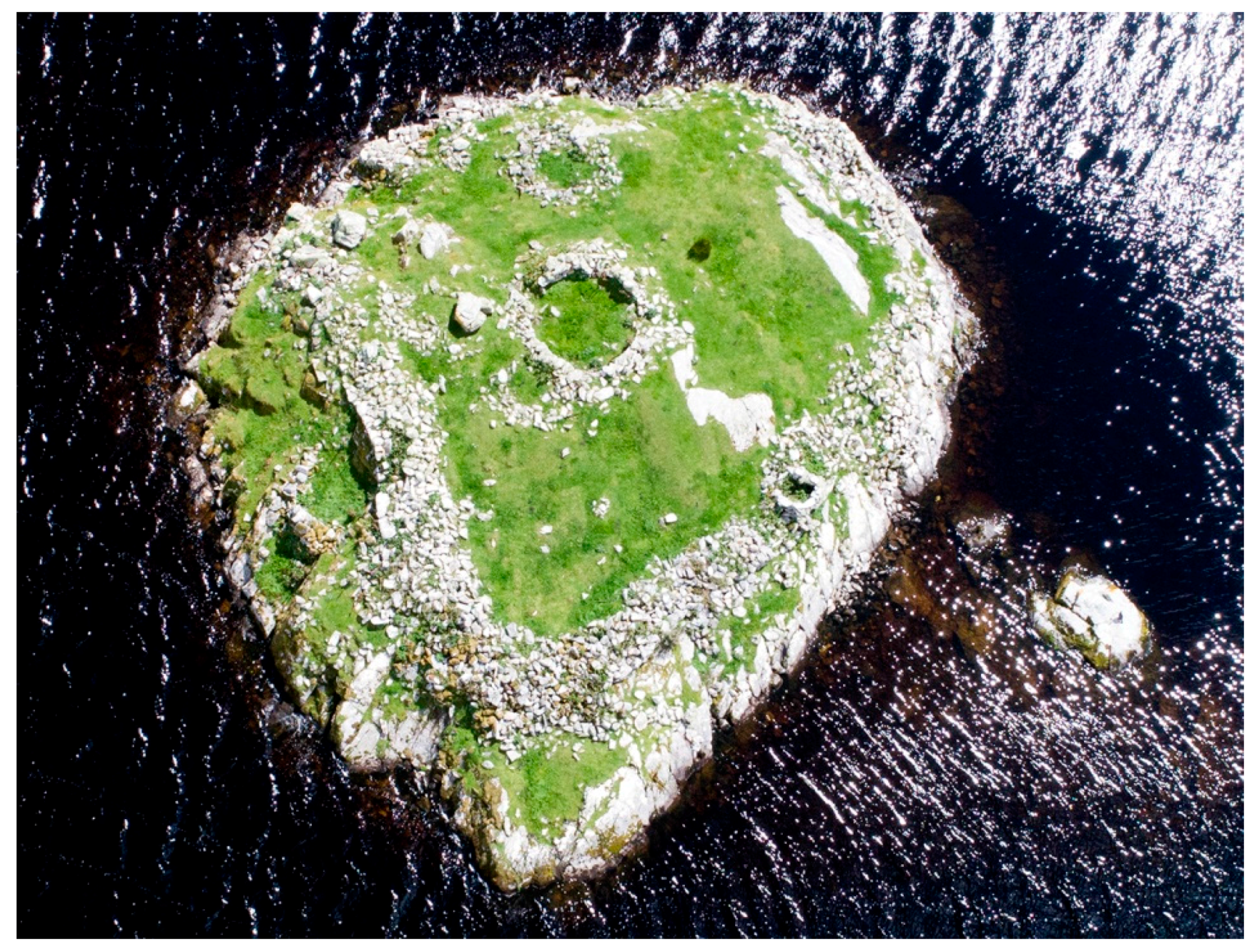
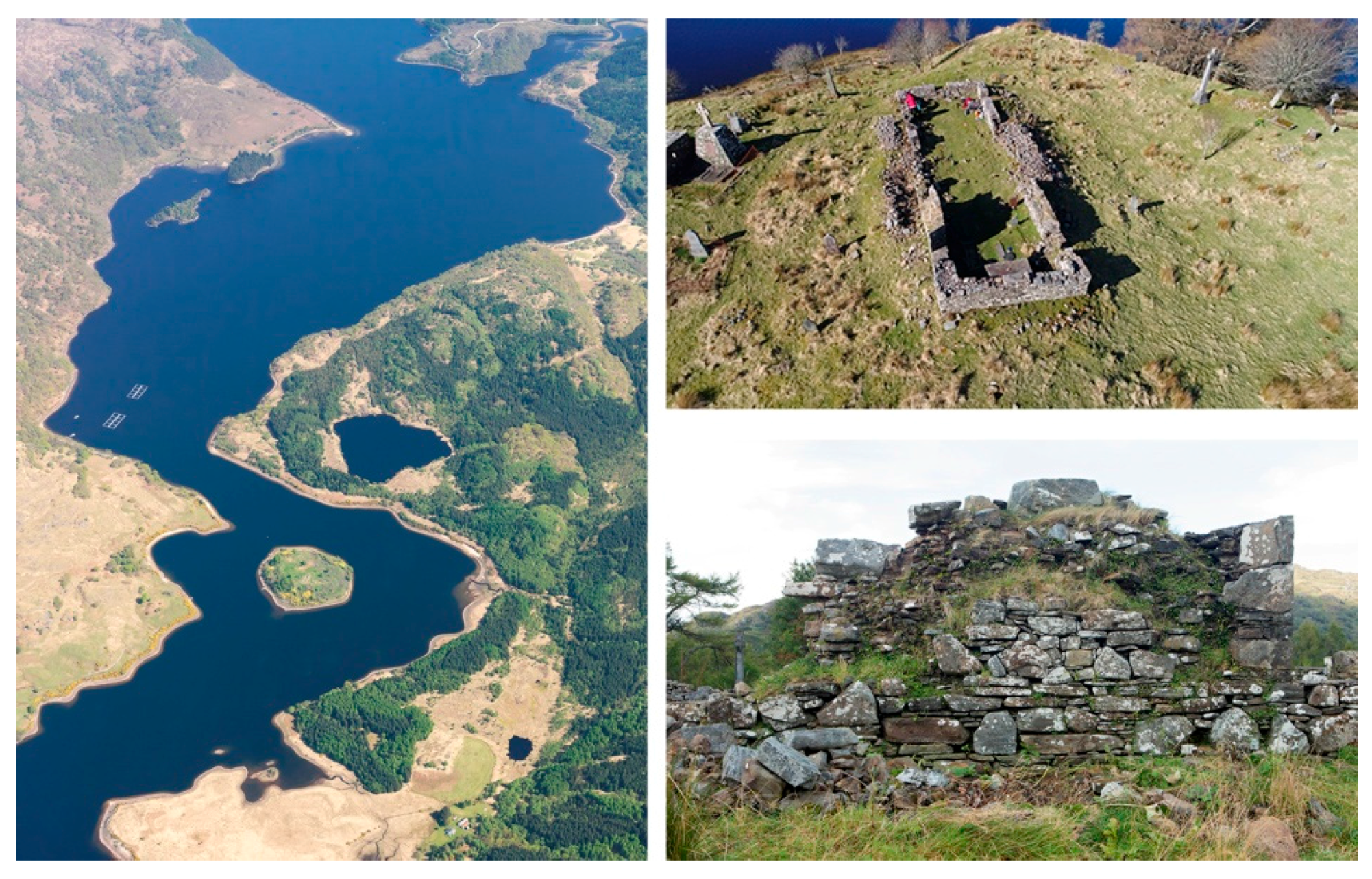
Figure 3.
The medieval church at Eilean Fhianain [20] is shown here in a nested approach of photographic documentation that formed one aspect of the site record. The oblique image taken from 1000 m above the site (left) shows the wider context; the UAV image capturing an oblique view of the church (top right); and the ground photograph (bottom right) illustrating some of the surviving medieval fabric within the much-restored ruin. DP110068, DP249987, DP262795 © Historic Environment Scotland.

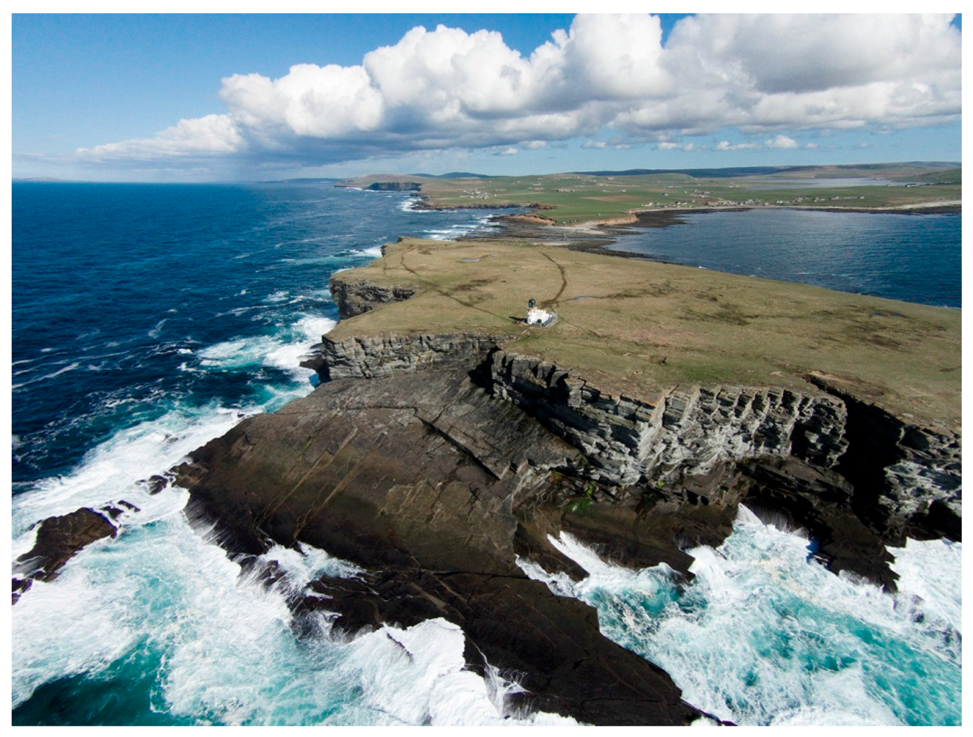
Figure 4.
Brough of Birsay, Orkney [21]. The fundamental rules of photography also apply to the UAV and no amount of technical wizardry can account for poor weather and light, or poor composition. The technical quality of imagery is also open to major variations, and in general terms there is a balance here between the cost of the equipment and its ease of use on the one hand, and the quality of the data captured on the other. DP214555 © Historic Environment Scotland.

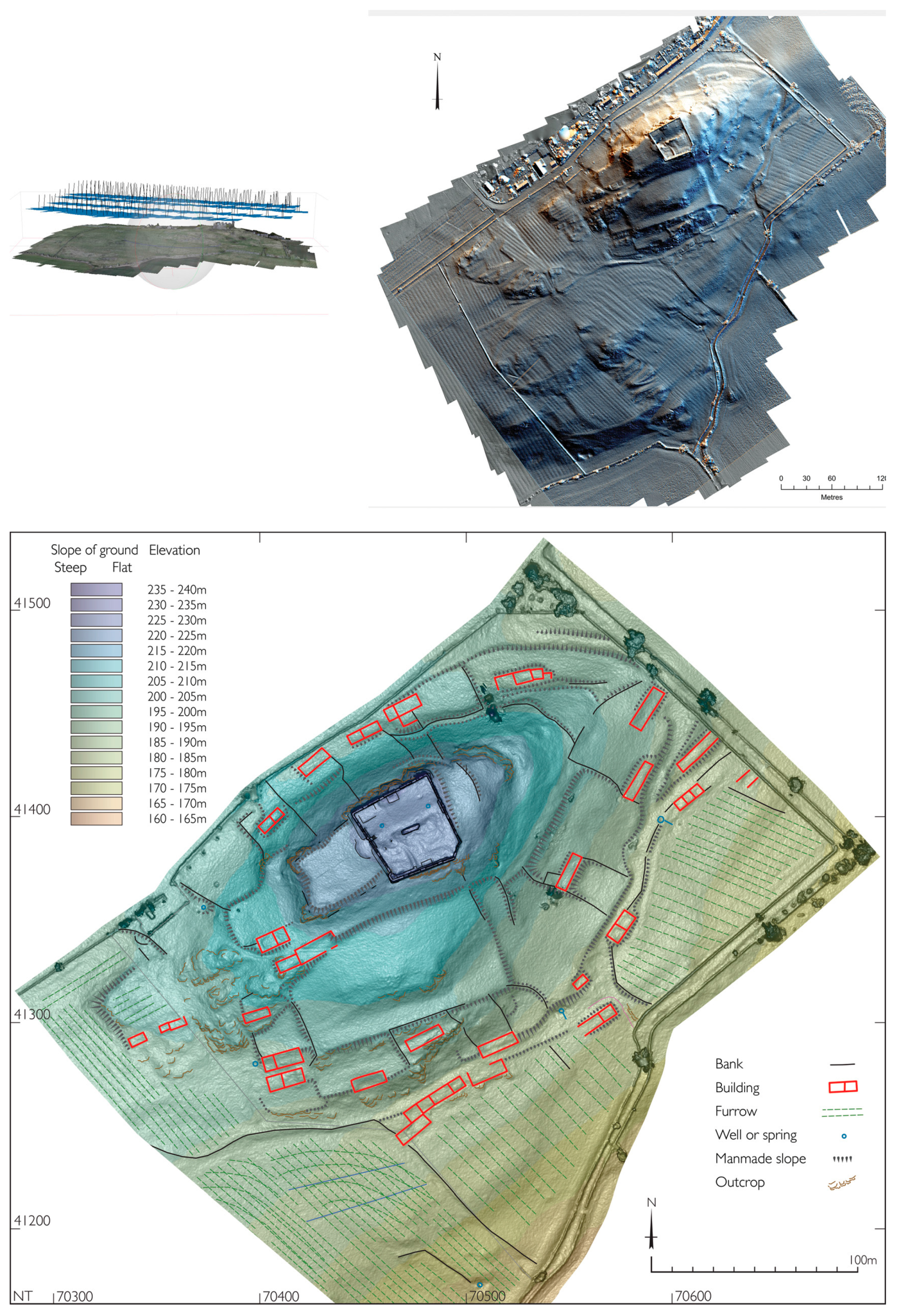
Figure 5.
UAV aerial photographs were processed through Agisoft Photoscan software (top left) to provide the basis for visualisations of the derived DSM (top right), which were used in an iterative process involving desk-based and field observation, with an interpretative archaeological plan as the primary output (bottom). SC1539983, SC1574488 © Historic Environment Scotland.

Figure 6.
The flexible and cost-effective Tarot 680 Pro hexacopter on a landing pad, with Parrot Sequoia mounted on the underside (left); and example of the black and white GCP targets utilised in the field (right). © C Moriarty.
Figure 6.
The flexible and cost-effective Tarot 680 Pro hexacopter on a landing pad, with Parrot Sequoia mounted on the underside (left); and example of the black and white GCP targets utilised in the field (right). © C Moriarty.
Figure 7.
Separability of archaeological objects over time, measured using Jeffries–Matusita distance for RGB imagery and histogram separability (M-Statistic) for greyscale conversions, with soil moisture deficits for a 40 km regional grid within which the test site is located shown below (data from Met Office). © C Moriarty.
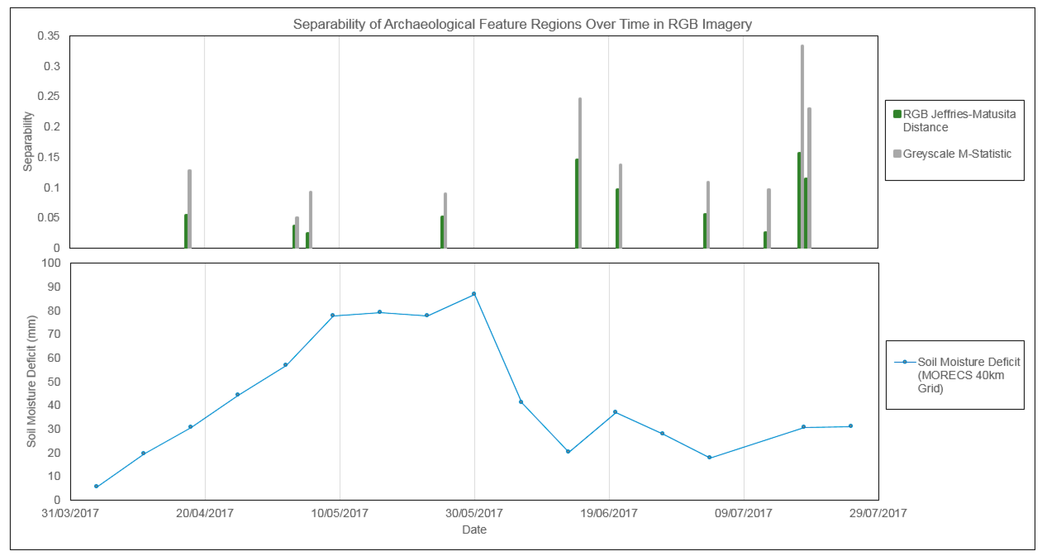
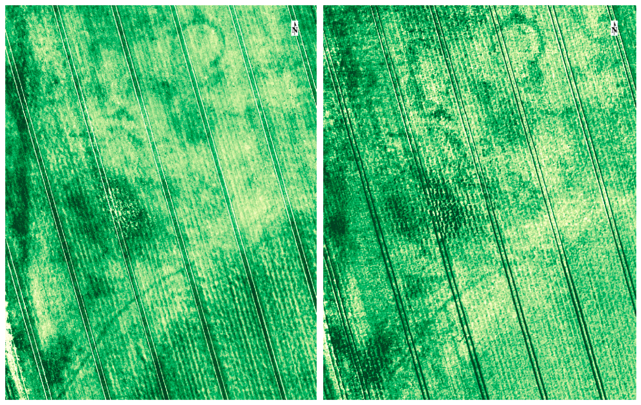
Figure 8.
Comparison of image detail in multispectral index map (12 July 2017 Simple Ratio, (left)) to RGB photograph (17 July 2017 greyscale conversion, (right)). © C Moriarty.
Figure 8.
Comparison of image detail in multispectral index map (12 July 2017 Simple Ratio, (left)) to RGB photograph (17 July 2017 greyscale conversion, (right)). © C Moriarty.

Table 1.
Options review for Historic Environment Scotland archaeological unmanned aerial vehicles (UAV) photographic applications.
Table 1.
Options review for Historic Environment Scotland archaeological unmanned aerial vehicles (UAV) photographic applications.
| Options | Pros | Cons |
|---|---|---|
| Buy UAV | In house, readily available at short notice | Costs of equipment, maintenance, training, developing competence, operations manual |
| Flexibility to use at short notice | Must be used regularly to maintain operator competence | |
| Archaeological imperatives drive image capture | Potential damage/total loss of equipment | |
| HES liable for insurance and public liability | ||
| Requires staff time (ideally 2 operators) | ||
| Rapidly developing field, legal framework likely to change | ||
| Buy Cheap (e.g., <2000 GBP) | Low cost | Limited applications/poor results |
| Allows experimentation and development | Poor results may lead to disappointment | |
| Limited payload | ||
| Buy Expensive | More versatile | Greater liability for damage/loss |
| High quality imagery | Increased maintenance issues | |
| Contractor | Risk free, if specification is clear | Costs for individual jobs are high |
| Contractors should keep up to date with developments and maintain operator expertise | Availability may not be “instant” | |
| Different contractors for different jobs as appropriate | Intellectual Property Rights would require clarification | |
| H&S, insurance, liability, machine maintenance on contractor | Limited in-house knowledge to direct operations and develop programme, and limited competencies to understand the structure and quality of data |
Table 2.
Specifications for the Parrot Sequoia and the Sunshine sensor.
| Main Unit | Dimensions | 59 mm × 41 mm × 28 mm |
| Weight | 72 g | |
| RGB Camera | Camera Resolution | 16 MP |
| Image size | 4608 × 3456 pixels | |
| Shutter release | Rolling Shutter | |
| Focal length | 4.88 mm | |
| Multispectral Camera | Camera Resolution | 1.2 MP |
| Image size | 1280 × 960 pixels | |
| Shutter release | Global Shutter | |
| Focal length | 3.98 mm | |
| Wavelengths | Green 550 nm (40 nm width) | |
| Red 660 nm (40 nm width) | ||
| Red-edge 735 nm (10 nm width) | ||
| Near Infrared 790 nm (40 nm width) | ||
| Additional features | Internal Motion Unit (IMU), magnetometer | |
| Sunshine Sensor | Dimensions | 47 mm × 39.6 mm × 18.5 mm |
| Weight | 35 g | |
| Spectral Sensors | Green, Red, Red-edge, Near Infrared | |
| Additional features | Global Positioning System (GPS), IMU, magnetometer |
© 2017 by the authors. Licensee MDPI, Basel, Switzerland. This article is an open access article distributed under the terms and conditions of the Creative Commons Attribution (CC BY) license (http://creativecommons.org/licenses/by/4.0/).
Share and Cite
MDPI and ACS Style
Cowley, D.C.; Moriarty, C.; Geddes, G.; Brown, G.L.; Wade, T.; Nichol, C.J. UAVs in Context: Archaeological Airborne Recording in a National Body of Survey and Record. Drones 2018, 2, 2. https://doi.org/10.3390/drones2010002
AMA Style
Cowley DC, Moriarty C, Geddes G, Brown GL, Wade T, Nichol CJ. UAVs in Context: Archaeological Airborne Recording in a National Body of Survey and Record. Drones. 2018; 2(1):2. https://doi.org/10.3390/drones2010002
Chicago/Turabian StyleCowley, David C., Charles Moriarty, George Geddes, Georgina L. Brown, Tom Wade, and Caroline J. Nichol. 2018. "UAVs in Context: Archaeological Airborne Recording in a National Body of Survey and Record" Drones 2, no. 1: 2. https://doi.org/10.3390/drones2010002