

J. Mar. Sci. Eng. 2024, 12(5), 711; https://doi.org/10.3390/jmse12050711 (registering DOI) - 25 Apr 2024
Abstract
Unmanned surface vehicle (USV)’s motion is represented by time-series data that exhibit highly nonlinear and non-stationary features, significantly influenced by environmental factors, such as wind speed and waves, when sailing on the sea. The accurate prediction of USV motion, particularly crucial parameters, such
[...] Read more.
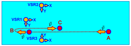
Unmanned surface vehicle (USV)’s motion is represented by time-series data that exhibit highly nonlinear and non-stationary features, significantly influenced by environmental factors, such as wind speed and waves, when sailing on the sea. The accurate prediction of USV motion, particularly crucial parameters, such as the roll angle and pitch angle, is imperative for ensuring safe navigation. However, traditional and single prediction models often struggle with low accuracy and fail to capture the intricate spatial–temporal dependencies among multiple input variables. To address these limitations, this paper proposes a prediction approach integrating temporal convolutional network (TCN) and bi-directional long short-term memory network (Bi-LSTM) models, augmented with a temporal pattern attention (TPA) mechanism, termed the TCN-Bi-LSTM-TPA (TBT) USV motion predictor. This hybrid model effectively combines the strengths of TCN and Bi-LSTM architectures to extract long-term temporal features and bi-directional dependencies. The introduction of the TPA mechanism enhances the model’s capability to extract spatial information, crucial for understanding the intricate interplay of various motion data. By integrating the features extracted by TCN with the output of the attention mechanism, the model incorporates additional contextual information, thereby improving prediction accuracy. To evaluate the performance of the proposed model, we conducted experiments using real USV motion data and calculated four evaluation metrics: mean square error (MSE), mean absolute error (MAE), mean absolute percentage error (MAPE), and R-squared (R2). The results demonstrate the superior accuracy of the TCN-Bi-LSTM-TPA hybrid model in predicting USV roll angle and pitch angle, validating its effectiveness in addressing the challenges of multivariate USV motion prediction.
Full article
(This article belongs to the Section Ocean Engineering)


