Article

Towards Personally Relevant Navigation: The Differential Effects of Cognitive Style and Map Orientation on Spatial Knowledge Development

1
GE Research, Niskayuna, New York, NY 12309, USA
2
Department of Construction Science, Texas A&M University, College Station, TX 77840, USA
3
Department of Construction Management, Bowling Green State University, Bowling Green, OH 43403, USA
*
Author to whom correspondence should be addressed.
Appl. Sci. 2024, 14(10), 4012; https://doi.org/10.3390/app14104012
Submission received: 26 March 2024 / Revised: 28 April 2024 / Accepted: 30 April 2024 / Published: 9 May 2024

Abstract

:
Under emergencies such as floods and fires or during indoor navigation where cues from local landmarks and a Global Positioning System (GPS) are no longer available, the acquisition of comprehensive environmental representation becomes particularly important. Several studies demonstrated that individual differences in cognitive style might play an important role in creating a complete environmental representation and spatial navigation. However, this relationship between cognitive style and spatial navigation is not well researched. This study hypothesized that a specific type of map orientation (north-up vs. forward-up) might be more efficient for individuals with different cognitive styles. Forty participants were recruited to perform spatial tasks in a virtual maze environment to understand how cognitive style may relate to spatial navigation abilities, particularly the acquisition of survey and route knowledge. To measure survey knowledge, pointing direction tests and sketch map tests were employed, whereas, for route knowledge, the landmark sequencing test and route retracing test were employed. The results showed that both field-dependent and field-independent participants showed more accurate canonical organization in their sketch map task with a north-up map than with a forward-up map, with field-independent participants outperforming field-dependent participants in canonical organization scores. The map orientation did not influence the performance of Field-Independent participants on the pointing direct test, with field-dependent participants showing higher angular error with north-up maps. Regarding route knowledge, field-independent participants had more accurate responses in the landmark sequencing tests with a north-up map than with a forward-up map. On the other hand, field-dependent participants had higher accuracy in landmark sequencing tests in the forward-up map condition than in the north-up map condition. In the route retracing test, however, the map orientation had no statistically significant effect on different cognitive style groups. The results indicate that cognitive style may affect the relationship between map orientation and spatial knowledge acquisition.

1. Introduction

Spatial navigation means an individual’s ability to locate and navigate through an environment using spatial cues [1]. This ability has been considered critical to daily life as we constantly migrate between known and unknown locations. Moreover, knowing the detailed internal connectivity of space is vital to shorten the navigation time, and more importantly the evacuation time, especially during crowd evacuation from large and complex building spaces (e.g., sports events or concerts). Pelechano and Badler [2] simulated evacuation during fires occurring at several sites within a building. The total evacuation time decreased as the number of trained agents increased. Their results also showed that evacuation time might be significantly reduced if trained individuals comprise at least 10% of the total building population [2]. Recently, Snopkova et al. [3] utilized Virtual Reality (VR) to examine 72 subjects’ evacuation retracing strategies and found that their retrace ability is significantly impacted by spatial designs (e.g., the width of hallways). Recent studies have shown that individuals navigating with mobile technology have poor spatial knowledge acquisition [4]. For instance, Dahmani and Bohbot [5] concluded that the use of a Global Positioning System (GPS) may adversely affect spatial memory during spatial navigation. Likewise, Yount et al. [6] revealed that using Augmented Reality (AR) for navigation assistance can enhance driving performance but gravely impair route learning as compared to maps. Many researchers have demonstrated that this lapse of attention to surroundings is due to the use of mobile navigation devices and their continuous spatial updating that adversely impacts spatial learning [7,8]. Another possible cause of spatial knowledge degradation could be a discrepancy between the information provided via a digital map and individual differences in inherent spatial schemata used for interpreting spatial relations. For example, recent investigations suggested that our cognitive survey maps are not always oriented with reference to the north [9,10,11]. Instead, they can be oriented with respect to convenient reference systems for organizing spatial knowledge, such as major streets. In a recent study by Zhao et al. [12], the role of north-up, forward-up, and guiding arrow map orientations in spatial navigation was examined. Their results showed that north-up maps initially showed less error in perceiving relative direction, but eventually, the spatial navigation performance of all three was similar. In addition, Blajenkova et al. [13] found evidence of individual differences in the use of spatial reference frames (spatial strategy), which is related to the types of spatial representation an individual creates. For example, participants who rely on landmark features during navigation form different spatial representations than those on directional cues (e.g., turns and direction). Accordingly, it is necessary to understand why individuals are different in their navigation ability and what are the internal variables involved in navigation activity.
Several studies demonstrated that individual differences may be important in spatial navigation. For example, Ishikawa and Montello [14] found that some participants obtained spatial knowledge about a learned environment within the first exposure. In contrast, some did not show any improvement at all over a 14-week spatial navigation study. They argued that individual variance in performance in spatial knowledge tasks is correlated with individual traits such as spatial ability. Recently, Newcombe et al. [15] discussed how individual differences such as stress levels and types, gender, and other affective states may influence spatial navigation. Likewise, Ishikawa [16] discussed how spatial ability, as well as working memory, spatial anxiety, personality traits, spatial experience, and sense of direction, may influence cognitive mapping and spatial knowledge acquisition. Studies have also argued that individual differences in spatial ability may correlate with individual “enduring characteristics” [17], which are consistent across time and context.

1.1. Cognitive Style

Research has suggested that individual personality, especially cognitive style, may relate to individual spatial learning [18]. Cognitive style refers to preferred ways or strategies in which individuals acquire and process information, which are expected to be consistent across time and contexts [19]. Cognitive style has traditionally been considered dimensional [20,21]. Field independence and field dependence are the most well-known dimensions classifying individual cognitive styles [22,23]. Field-independent (FI) learners can distinguish figures as discrete from their backgrounds, whereas field-dependent (FD) individuals learn figures as an integral part of the background in which the figures are presented [23,24]. Kirby et al. [25] have suggested that FD learners are more holistic and rely more on imagery. FI learners, by contrast, rely more on analytical strategies [25]. The popular measures of cognitive style used in the spatial learning literature include the Group Embedded Figures Test (GEFT) [26], the Gestalt Completion Test [27], and the Hidden Patterns Test [28].

1.2. Cognitive Style and Map Orientation

Some studies also found that individual factors like cognitive style are highly associated with spatial learning perspectives. Cheng et al. [29] examined the impact of field dependency and map type on strategies of wayfinding and found that females applied route strategies more than males due to their field dependence. Nori et al. [30] analyzed the ability to regenerate a path from diverse perspectives and found that the FI cognitive style was more accurate and faster than the FD style. Pazzaglia and Taylor [31] showed that people with an FD predisposition performed better with a ground-level learning perspective than with an aerial perspective. Conversely, people with an FI predisposition were less dependent on learning perspective. In other words, people with a high preference for survey representation are more flexible to change from one perspective to another. Li et al. [32] examined the effect of cognitive style and the perspective of a map on orientation tasks and navigating tasks. In navigating tasks, they measured task completion time and how often participants referred to the map while navigating in a virtual environment. Two different map perspectives were provided: one with a north-up and the other with a track-up map. The results indicated that FD individuals perform significantly better on orienting tasks with the track-up map than with the north-up map. FI individuals, however, did not show any difference in the orienting tasks with both the map perspectives. In navigating tasks, FD individuals performed significantly better when they used a track-up map than a north-up map. On the other hand, FI individuals showed superior performance when using a north-up map. Given the above evidence, a specific learning perspective may be more efficient than the others for individuals with different cognitive styles.

1.3. Cognitive Style and Spatial Ability

It has been demonstrated that individual spatial abilities, especially spatial visualization and spatial orientation, affect the type of cognitive style or vice versa. Akkaya [33] investigated the spatial ability–cognitive style relationship of 393 high school students in Turkey and found that this relationship is moderated by gender. A study by Boccia et al. [34] investigated the correlation between cognitive style and spatial abilities. Their study used mental rotation tasks to measure spatial visualization ability and perspective-taking tasks to assess spatial orientation ability. Their results showed that individuals’ predisposition towards field independence predicted higher performance on mental rotation and perspective-taking tasks. Bintoro et al. [35] studied how the field dependency of high school students influences their spatial thinking process. Their results demonstrated that FD students have difficulty creating spatial representation and exhibit the inaccuracy of spatial thinking. Likewise, Li et al. [32] reported that FI individuals showed higher accuracy in mental rotation tasks than FD ones. The different performance on spatial ability tasks depending on the type of cognitive style may, to some extent, result from the different ways individuals organize/process spatial information. FI individuals are more likely to perceive a field in terms of its components in processing spatial information, whereas FD individuals perceive the field as a whole [24]. Therefore, spatial tasks that require extracting input information (objects) from contextual surroundings may be more difficult for FD individuals [32,34].

1.4. Cognitive Style and Spatial Strategy

The correlation between cognitive style and learning perspective discussed above may also be explained by an individual’s predisposition towards processing environmental information. Several studies suggested that different cognitive styles react differently to different types of spatial information gathering. For example, Denis et al. [36] conducted a study with different cognitive style participants. One group showed a preference for adopting survey representations, whereas the other group preferred remembering landmarks. They provided only a verbal description of a route, which does not describe spatial features of the environment holistically. The group that preferred a survey representation made more navigation errors than those that used landmark cues. Pazzaglia and De Beni [37] showed similar findings that the group with a higher preference for adopting survey representation made more mistakes in navigation when they were provided with verbal route directions instead of holistic spatial information. Bocchi et al. [38] examined how field independence may impact spatial strategy and found that FI individuals predicted the response time of the reordering path by imagining going from one pace to another. Nori et al. [30] studied the FI and FD cognitive styles and found evidence to support that cognitive style may affect participants’ ability to remember a path from a different standpoint in virtual environments. These results suggest that providing appropriate spatial information based on personal cognitive style is important to maximize spatial learning. However, only a few studies investigated the relationship between cognitive style and spatial strategy.

1.5. Cognitive Style and Spatial Knowledge

The effect of cognitive style on spatial knowledge has mixed results across studies. Boccia et al. [39] showed that FI individuals are associated with better performance on survey tasks. They concluded that the more an individual is FI, the more developed the survey knowledge. On the other hand, Kroutter [40] found that cognitive style was associated with navigation behavior but not with learning outcomes (spatial knowledge). Studies suggest that FD individuals mostly depend on visual cues, whereas FI people rely on an analytical approach to spatial representation [41]. It was suggested that the dimension of cognitive style affected an individual’s spatial strategy (the way of processing environmental information) but not spatial knowledge. Therefore, more studies may be needed to examine the effect of cognitive style on spatial knowledge.
In conclusion, previous studies have demonstrated individual cognitive styles may relate to essential factors that affect human spatial navigation. Different levels of ability to extract input information from contextual surroundings depending on an individual’s cognitive style may influence spatial ability, the use of spatial strategy, and a favored spatial learning perspective. However, mixed results were found regarding the spatial learning outcomes (spatial knowledge).

2. Methodology

2.1. Research Hypothesis

Given the evidence that a particular type of learning perspective may be more efficient than the others for individuals with different cognitive styles [31,32], three important questions arise that must be answered to understand cognitive style, spatial ability, and navigation relationship: (1) What are different individual variables that affect spatial navigation? (2) How is individual cognitive style related to spatial navigation? (3) How can we develop individual-appropriate navigational interventions not only for guiding direction to the destination but also for helping to acquire a spatial knowledge of the environment? To answer these key research questions, we conducted a study to test three research hypotheses: (H1) FI participants will have more accurate spatial knowledge in the north-up map than in the forward-up map condition; (H2) FD participants will have more accurate spatial knowledge in the forward-up map condition than in the north-up map condition; and (H3) FI participants will achieve higher scores on all spatial ability dimensions than FD participants, given their better ability to extract salient information from the surrounding field and recognize other people’s perspective [32,34].

2.2. Participants

In this study, 40 participants, including 17 females, with normal or corrected-to-normal vision, were recruited through an announcement sent through the university’s email system. The participant population was well balanced between males (57.5%) and females (42.5%), with both genders having a similar mean age. As the ages of the participants were homogenous, no age effects were considered in the analysis. The mean age of the participants was 22.4 years, with a standard deviation of 4.74. All participants were either students or staff members from Texas A&M University. The inclusion age criterion was young adults between 18 to 45 years old. This age criterion is selected because, cognitively speaking, there are age differences in representing the environment layout and spatial navigation performance [42,43,44]. All participants provided consent through an electronic consent form before the study through DocuSign, and the study was approved by the university’s Institutional Review Board (IRB). All participants were compensated with a USD 15 gift card for their participation.

2.3. Study Environment

The VR environments were created in the Unity 3D game engine. Unity 3D allows the customization of environments and interactions through scripts to emulate specific performance and functionality. The environments for testing individual navigation performance were based on a maze with perpendicular turns (see Figure 1). A virtual maze enables the creation of the same stimulus conditions for all study conditions, giving more control over experimental settings. Finding two environments with the same stimulus conditions is challenging in the real world. For these reasons, a maze has been a popular environmental setting in previous spatial navigation studies [45,46].
In each maze environment, there were seven landmarks positioned along the path. The landmarks are natural or artificial elements that people usually see daily. Maze 1 had a stool, chest, tree, desk, cone, bike, and globe as landmarks. Maze 2 contained a drawer, lamp, house plant, TV, cone, motorcycle, and tree as landmarks. The height of the maze walls was intentionally designed low so that participants could establish internal connectivity between landmarks. The low maze wall also allowed the use of global landmarks for those who prefer to use the allocentric (survey) strategy. Figure 2 presents a layout of the two maze environments used in this study. The red line indicates the route participants had to follow. The small circles represent the position of the seven local landmarks in each maze.
The GPS-like map and a compass indicating the virtual north were displayed in the upper left corner. The participant’s position and facing direction were shown on the map with an arrow icon along with the guiding trail. This guide map was given only during the learning phase. The guide map always maintained one of the two orientations: (1) north-up: the map maintained constant orientation aligned with the virtual north direction; (2) forward-up: the map was always upright with respect to the participant’s facing direction (see Figure 3). The two different maze environments were constructed so that participants could experience all map conditions (e.g., north-up and forward-up) without the learning effect. The two environments, however, are the same regarding the number of landmarks, segments, and intersections. Each maze had a simple textured wall with a white tile floor. The basic structure of the maze is the same as those used in previous studies such as Castelli et al. [47].

2.4. Test Materials

2.4.1. Spatial Ability Measures

All three dimensions of spatial ability (i.e., spatial visualization, spatial orientation, and spatial relation) were tested. Evidence shows that moving through space requires not just one aspect of spatial ability but a combination of its sub-dimensions, as we need to perceive a spatial environment correctly, find shortcuts, and keep track of locations [48]. Some studies concluded that spatial abilities (specifically, spatial visualization and spatial orientation) predict spatial navigation performance, and both may involve similar cognitive processes [49,50,51]. However, spatial relation ability has received less attention than the other two dimensions. Kozhevnikov et al. [51] have suggested that future research is needed to identify other aspects of spatial abilities (e.g., spatial relations) that may contribute to navigational tasks. They further indicated that it would be beneficial not only for advancing navigation theory but also for personal training. Therefore, the study comprehensively tested each participant’s three spatial ability dimensions. We applied the following three spatial ability assessments that have predominantly been used in spatial ability research: the Purdue Spatial Visualization Test: Rotation (PSVT: R), the Perspective-Taking Ability Test (PTA), and the Card Rotation Test (see Figure 4).

2.4.2. Cognitive Style Measure

We used the Group Embedded Figures Test (GEFT), the most widely used instrument for individual cognitive style, to measure cognitive style [26]. The test provides simple visual figures embedded inside complicated visual figures. The participants were asked to locate the simple hidden figure in the complex figure within a given time (20 min). The test consisted of three sections. The first was the practice section to familiarize the participants with the test. The score of the first section was not included in the total score. The score ranged from 0 to 18. A score between 0 to 11 identified participants as FD individuals, whereas a score between 12 to 18 identified participants as FI individuals.

2.4.3. Route Knowledge Measures

We used the landmark sequencing test that assesses participants’ route knowledge. Eight pairs of photos depicted scenes from the experiment environment (see Figure 5). The participants were told to judge which scene occurred first while walking from the start point to the endpoint. A participant’s score was the sum of correct responses (ranging from 0 to 8).
We also applied another route knowledge test [52], the route retracing test (explained in more detail in the procedure in the subsequent sections). When participants reached the maze’s endpoint, they were asked to walk back to the starting point following the same route they had taken. The total egress time of the route retracing was used as the route knowledge indicator.

2.4.4. Survey Knowledge Measures

The pointing direction task [51] was used to access participants’ survey knowledge. Participants were given a list of landmarks in a random order with a name tag to avoid the confusion of matching their names (see Figure 6). The participants needed to rely solely on their mental representation of the maze to answer the question. They were asked to imagine standing in a given position at the maze, facing one landmark, and pointing to another (e.g., Imagine you are standing at the “Tree” facing the “Desk.” Point to the “Stool”). There was a total of 12 items. The absolute pointing angular error was measured. There was no time limitation on this task. The test items were programmed and presented in virtual environments using Unity. The angle to the third landmark (i.e., the red line) can be rotated by pressing the keyboard’s left and right arrow keys. Clicking the next button submits the answer and directs to the next item.
The sketch map test has been widely adopted in many spatial studies to measure survey knowledge of the learned environments [53,54,55]. In this test, participants were asked to draw a map of the space with landmarks and other spatial features on a sheet of paper. They were encouraged to draw as much detail as possible in 10 min. At the end of the study, they were asked to scan the hand-drawn maps and email them to the investigator. An example of the sketch map test is shown in Figure 7.

2.5. Procedure

Participants began with a demographic questionnaire and three spatial ability tests (i.e., PSVT: R, PTA, and Cube Comparison), followed by the GEFT. Then, the participants were given verbal instructions about the navigation test in the virtual maze. Since the study was designed to be contact-free, the investigator shared the screen through the Zoom application and assigned the keyboard and mouse control over to the participant. In the virtual environment, they were able to passively walk along a route by pressing the following keys of their keyboards: W (going forward), S (going backward), A (left turn), and D (right turn).
Before starting the experiment in virtual maze environments, participants familiarized themselves with the keyboard button functions for 5 min by exploring a practice maze. The practice maze had graphical elements such as patterns and textures for walls and floors identical to those used in the experimental phase but with a much simpler route design. No data were collected in this practice phase.
After the participants were familiarized with the control of the virtual environments in the practice maze, they were introduced to either Maze A or B (see Figure 2). In each maze environment, there were two phases. The first phase was learning the environment with a guide map: (1) the north-up map or (2) the forward-up map. The order of environments (Maze A and Maze B) and the orientation of the guide map (North-Up and Forward-Up) were counterbalanced across all participants to eliminate any ordering effect (see Table 1). Each map condition had a single trial since the map environment was relatively simple.
Initially, participants were asked to explore the environment along the prescribed route guided by a map to adopt an entire maze configuration. All participants were encouraged to remember the whole layout of the environment. There was no time limitation in the learning phase. To ensure that participants always took the correct route, the investigator corrected them when necessary. Upon arriving at the endpoint, they were asked to trace back to the initial start point following the exact route they had taken. In this route retracing test, the guide map was not provided. Participants were supposed to rely on their mental representation of the environment. On reaching the start point, the total egress time was measured. No feedback on turning errors was provided during the route retracing test.
Next, participants completed the survey and route knowledge tests in the order of the pointing direction test, sketch map test, and landmark sequencing test. Subjects then took a short break. After the short break, participants were introduced to the second maze environment. The same procedure as the first maze was repeated for the second maze. In the second maze, however, participants were assigned a different orientation guide map than the one they had in the first maze. The effectiveness of the intervention (map orientation) was inferred from the participants’ performance on both route and survey knowledge tasks. The total study duration was approximately two hours.

3. Results

After the data were gathered from participants, a statistical analysis was performed using Jasp (version 0.14.1). In this section, detailed information about the statistical results of this study is given. The descriptive analysis was conducted to obtain overall information about the statistical results. Repeated measures ANOVA with covariates, independent sample t-test, and correlation were also used. Firstly, results of descriptive analysis of participants’ demographics in terms of gender, major, cognitive style, navigation strategy, and spatial abilities were reported. After that, the interaction effect of map orientation and cognitive style on spatial knowledge tasks was assessed.

3.1. Results: Participants’ Demographics

This section reports the results of participants’ cognitive style measured with the Group Embedded Figures Test (GEFT) and spatial ability assessed using the Purdue Spatial Visualization Test: Rotations (PSVT: R), Perspective-Taking Ability (PTA) test, and Cube Comparison (CC) Test. Their spatial ability was measured through spatial visualization (mental rotation measured with PSVT: R), spatial relations (CC), and spatial orientation (PTA).

3.1.1. Participants’ Cognitive Style

The distribution of GEFT scores was not normal (skewness = −0.811, SE = 0.374). Participants with scores ranging from 0 to 11 were classified as FD, and participants with scores between 12 to 18 were classified as FI (based on [56,57,58,59]). Specifically, 37.5% of the total participants were FD, and 62.5% were FI. Table 2 shows the differences in cognitive style between genders.

3.1.2. Spatial Abilities

The PSVT: R and Cube Comparison test data were coded as correct or incorrect. The PTA scores were calculated based on the degrees of deviation from the correct response. The smaller deviations showed better performance. Table 3 shows the results of participants’ performance in each spatial ability test in terms of means and standard deviation. The table also shows the difference in spatial ability scores between the two cognitive styles (FD vs. FI). In spatial visualization, the mean score of FI (M = 59) is higher than that of FD (M = 33.07) participants. The same trend was observed in spatial orientation: FI participants showed less angular error (M = 36.94) than FD (M = 56.8). In the spatial relation test, the mean score of FI participants (M = 53.25) is slightly higher than FD (M = 45).
Performing the independent sample t-test was considered to examine the effect of cognitive style on the three dimensions of spatial ability, i.e., spatial visualization, relations, and orientation. The Shapiro–Wilk normality test and Levene’s test of homogeneity of variance were also performed. Levene’s test result of no spatial ability data was statistically significant (p > 0.05), indicating that the assumption of equal variance was met. However, the Shapiro–Wilk test results showed a deviation from normality (p < 0.05) in spatial visualization and spatial orientation data. Therefore, the Mann–Whitney U test was performed for spatial visualization and spatial orientation. As Table S1 in the Supplementary Materials shows, there was a significant difference between cognitive style (FD vs. FI) for spatial visualization ability (U =38.5, p < 0.001) and spatial orientation (U = 172, p = 0.044). However, there was no significant difference in mean scores between FD and FI for spatial relation: t (38) = −1.531, p = 0.134.

3.2. The Effect of Map Orientation on Spatial Knowledge Development

This section offers results of participants’ spatial knowledge acquisition with north-up and forward-up map orientations to measure their route knowledge and survey knowledge. Their route knowledge was measured using a landmark sequencing test and a route retracing test, whereas survey knowledge was measured with a pointing direction task and a sketch map test.

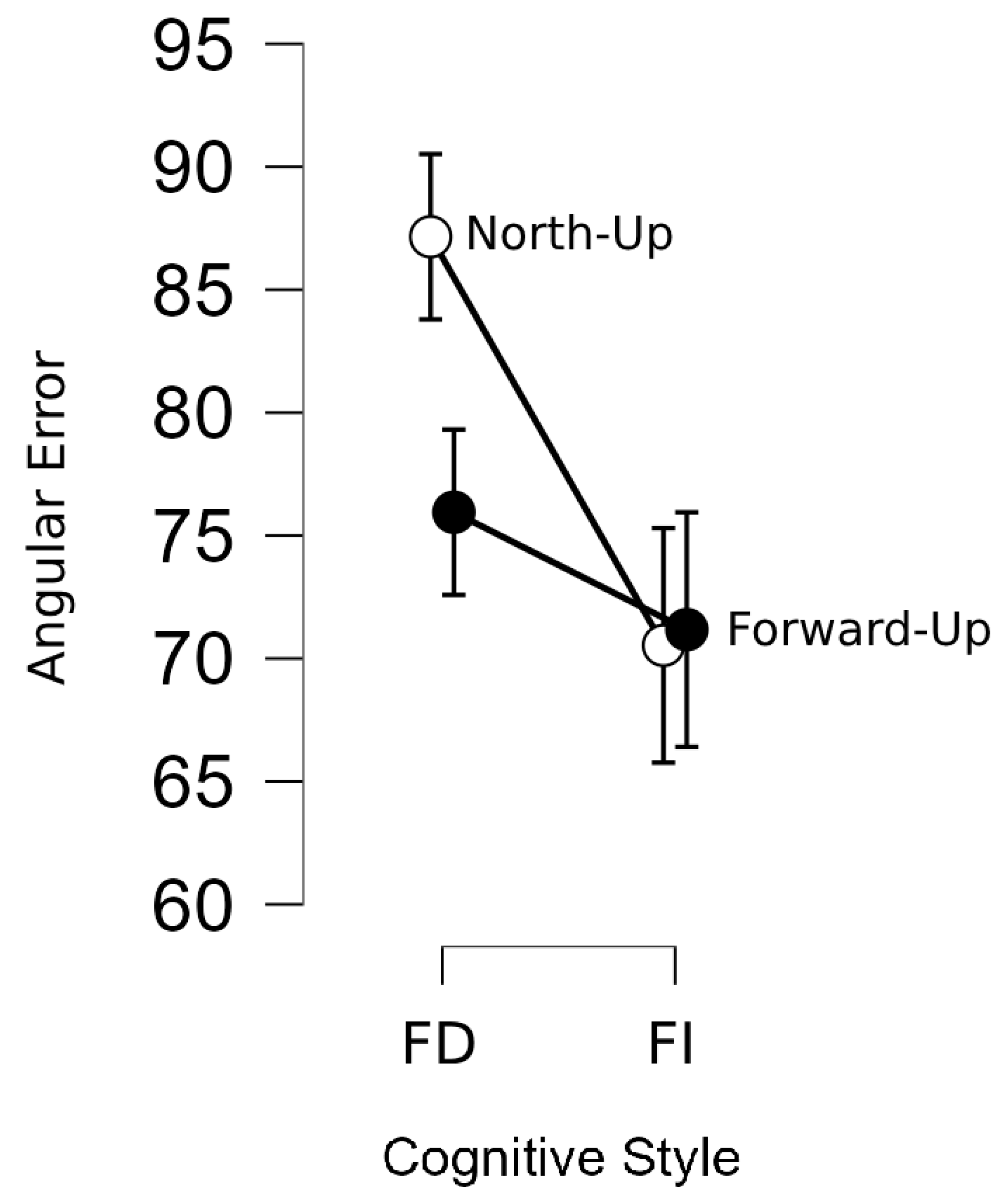
3.2.1. Pointing Direction Test by Cognitive Style

Table 4 shows the means and standard deviation of the angular error on the pointing direction test in each map orientation condition, categorized by the two cognitive style groups. The results indicated that FD participants had a higher angular error when using the north-up maps (M = 85.568, SD = 16.373) than when using the forward-up maps (M = 75.78, SD = 14.022). FI participants, on the other hand, had no considerable amount of difference in angular error between the north-up map (M = 70.576, SD = 26.281) and forward-up map (M = 71.245, SD = 25.688) conditions (see Figure 8). These results indicate that FD individuals may be affected by map orientation favoring the forward-up map when acquiring survey knowledge. On the other hand, FI individuals are not dependent on map orientation for acquiring survey knowledge.
To investigate whether the difference between cognitive groups with respect to the map orientation was statistically significant, a repeated measures ANOVA was performed on the pointing direction test with map orientation (North-up vs. Forward-up) as a within-subjects variable and cognitive style (FD vs. FI) as a between-subjects variable. As Table S2 in the Supplementary Materials shows, the main effect of map orientation on the pointing direction test’s accuracy was insignificant: F (1, 38) = 1.24, p = 0.273. There was no significant interaction between map orientation and cognitive style, F (1, 38) = 1.56, p = 0.219.

3.2.2. Sketch Map Test by Cognitive Style

The participants’ sketch map accuracy data were collected and analyzed in the Gardony Map Drawing Analyzer [60]. Three participants produced low-quality map drawings, which were difficult to analyze. These data points were excluded from the analysis, resulting in 37 sketch map data points in each map orientation condition. The sketch maps were analyzed according to two factors in the Gardony Map Drawing Analyzer: canonical organization and angle accuracy. The canonical organization score (ranging from 0 to 1) indicates the accuracy of the canonical relationships (N/S/E/W) for each landmark in the sketch map compared to the target environment (i.e., maze). A larger score indicates a more accurate representation of the environment. Angle accuracy indicates the accuracy of the angles among the landmarks on the sketch map. The score ranges from 0 to 1, with larger scores indicating more accurate inter-landmark angle representation [60].
The results of descriptive analysis for canonical organization and angle accuracy according to cognitive style are given in Table 5. For the canonical organization, the mean of participants classified as FD was lower (M = 0.568, SD = 0.205) than the mean score of FI participants (M = 0.631, SD = 0.2) under the north-up map condition. The same trend was observed in the forward-up map condition, where FD individuals showed lower performance (M = 0.5, SD = 0.249) than FI individuals (M = 0.543, SD = 0.223).
As Table 6 shows, for the angle accuracy scores in the north-up map condition, participants classified as FD showed lower performance (M = 0.596, SD = 0.175) than participants classified as FI (M = 0.640, SD = 0.206). On the contrary, in the forward-up map condition, FD participants achieved higher scores (M = 0.575, SD = 0.126) than FI ones (M = 0.508, SD = 0.201). One notable finding was that the mean difference between map orientation among the FI group showed a larger discrepancy when compared to the mean difference among the FD group (see Figure 9).
A further analysis was performed to investigate the effect of map orientation on survey knowledge regarding cognitive style. Another repeated measures ANOVA was conducted on each factor of sketch map data with map orientation (North-Up vs. Forward-Up) as a within-subject variable and cognitive style (FD vs. FI) as a between-subject variable. Tables S3 and S4 in the Supplementary Materials show the analysis results on canonical organization and angle accuracy, respectively. The results revealed no significant effect of map orientation on canonical organization (p > 0.05). There was no statistically significant effect for the angle accuracy score, but a trend toward significance was found: F (1, 34) = 4.056, p = 0.052. There was no significant interaction between the map orientation and cognitive style on both sketch map factors, indicating that participants’ cognitive style does not moderate the survey knowledge results under different map orientation conditions.

3.2.3. Landmark Sequencing by Cognitive Style

The results of mean differences in landmark sequencing accuracy according to cognitive style are given in Table 7. In the north-up map condition, the mean of participants classified as FD was lower (M = 3.846, SD = 1.068) than that of participants classified as FI (M = 5.65, SD = 1.182). The same trend was seen in the forward-up map condition, where FD individuals showed lower performance (M = 4.939, SD = 1.44) than FI individuals (M = 5.303, SD = 1.510). However, as shown in Figure 10, the mean difference in each map orientation condition among the FD group showed a larger discrepancy than the mean difference among the FI group.
To analyze the statistical effect of map orientation on landmark sequencing score regarding cognitive style, a repeated measures ANOVA was conducted with map orientation (North-Up vs. Forward-Up) as a within-subject variable and cognitive style (FD vs. FI) as a between-subject variable. There was no significant main effect of map orientation for landmark sequencing test scores [F (1, 35) = 2.891, p = 0.099], but there was a significant “map orientation × cognitive style” interaction: F (1, 35) = 6.27, p = 0.018 (see Table S5 in the Supplementary Materials). Post hoc comparisons for landmark sequencing revealed a significant difference between cognitive style groups (FD vs. FI) in the north-up map condition (p = 0.002). Also, a significant difference between map orientation (north-up vs. forward-up) among the FD group was found (p = 0.044) (See Table S6 in the Supplementary Materials).

3.2.4. Route Retracing by Cognitive Style

The egress task completion time from the endpoint to the start point was recorded in seconds. The results of mean differences in the egress time according to cognitive style are given in Table 8. In the north-up map condition, FD and FI participants took almost the same time on the route retracing task. The mean egress time for FD individuals was 145.769 s, and for FI individuals was 145.15 s. In the forward-up map condition, FI individuals took less time (M = 124.35, SD = 66.867), whereas FD individuals took considerably more time: M = 154.154, SD = 97.058 (see Figure 11).
Further analysis was performed to investigate the statistical effect of map orientation on the route retracing task regarding cognitive style (see Table S7 in the Supplementary Materials). A repeated measures ANOVA was conducted with map orientation as a within-subject variable and cognitive style as a between-subject variable. There was no significant main effect of map orientation on the route retracing task: F (1, 38) = 0.998, p = 0.324. In addition, there was no significant interaction between map orientation and cognitive style: F (1, 38) = 0.891, p = 0.351.

4. Discussion

4.1. Cognitive Style Difference

As the study hypothesized, participants who are field-independent (FI) in their cognitive style exhibit greater scores in spatial visualization and spatial orientation tests, which is partially in line with previous studies that have found FI learners outperforming the field-dependent (FD) learners in spatial visualization ability (i.e., mental rotation of an object) [32,34,61]. However, their studies did not examine the other dimensions of spatial abilities, such as spatial orientation and spatial relations. The results also align with the spatial navigation study by Nora et al. [30], concluding that FI individuals are able to predict a navigation path from even unfamiliar standpoints This study concluded that FI individuals outperformed FD individuals in the spatial orientation test, as indicated via greater scores on the PTA test. This finding agrees with Bocchi et al. [38] and Boccia et al. [39], who assert that FI people may perform better on perspective-taking tasks. There was, however, no considerable difference in spatial relations ability between FI and FD participants, which is contrary to the conclusions of some previous studies [38,39]. The reason for a different performance on spatial ability tasks depending on the type of cognitive style is unclear. Still, one may speculate that it could result from different ways individuals organize/process spatial information. As mentioned above, FD individuals have difficulty extracting salient information from the surrounding field, unlike FI individuals. Thus, they performed worse on those spatial ability tests, such as PSVT: R and PTA, which require disregarding the deceptive cues from the field [24,34].
Moreover, the study hypothesized that FI learners would be more likely to employ survey-based strategies than FD learners. In contrast, FD learners would be more likely to employ route-based strategies [29]. This assumption is based on the tendencies of each cognitive style in processing spatial information. FI individuals were known to rely on survey representation (i.e., NSWE), whereas FD individuals rely on directional-based cues. However, the results revealed no significant interaction between cognitive style and everyday navigation strategy, which is contrary to some previous studies [29,38,39].

4.2. The Effect of Map Orientation

This study also explored the effect of map orientation (north-up vs. forward-up) on acquiring spatial knowledge as a function of cognitive style. The use of a north-up map improved performance on the sketch map test regardless of participants’ cognitive style, meaning that individuals guided by a north-up map acquired more accurate spatial representation. After the cognitive style was considered, the impact of map orientation favoring the north-up map was noticeable in the overall completeness of the sketch map. In contrast to the study hypothesis, both FD and FI participants showed more accurate canonical organization in their sketch maps after a north-up map guided them. That means navigation aided by a north-up map helped them acquire more accurate canonical spatial information, even for FD individuals who favor directional cues. This differs slightly from Li et al. [32], who found that FD people perform better on task-up map orientation than on north-up maps, and Darken and Peterson [62], who found that egocentric and allocentric processing, which may be associated with FD and FI individuals, may favor forward-up and north-up maps, respectively. Given the learning traits of FD participants, the study assumed that FD individuals would adopt survey knowledge better with a forward-up map, which provides spatial information they could easily process. One possible explanation for these opposite results may be that providing information that could be easily processed may result in disregarding other spatial information. For example, since FD participants have a basic propensity to accept route knowledge more easily that involves sequential information [12,63], this propensity may have been further strengthened using the information given via the forward-up map. Participants commented in the forward-up map condition, “I can’t remember TV since I just follow the path.” Moreover, it has been noticed that they were easily confused about left or right turns in the north-up map since the map orientation is not aligned with their body orientation (i.e., the viewing direction). However, they may have been able to naturally acquire the configuration of the entire space through those efforts to align the view direction with the direction of the map, which could also explain the poor performance of FI individuals’ angle accuracy in the forward-up map condition.
Regarding route knowledge, as the study assumed, FI participants had more correct answers in the landmark sequencing tests after a north-up map guided them compared to their performance in forward-up map conditions. This finding is consistent with the results of Teghil et al. [64] showing that participants relied more on map-like allocentric mental representation to order landmarks than egocentric representation, considering that a north-up and a forward-up map may utilize allocentric and egocentric encoding, respectively. On the other hand, FD participants had higher accuracy in landmark sequencing tests in the forward-up map condition than their performance in the north-up map condition, which seems to align with studies such as Ferretti et al. [65], which concluded that an egocentric encoding system may be most fitting to landmark sequencing tasks. However, map orientation had no statistically significant effect on different cognitive style groups in the route retracing test. In contrast to the study hypothesis, the descriptive results show that FD participants took considerable time in the forward-up condition, which was even longer than their performance in the north-up map condition. The route retracing test requiring both route and survey knowledge could explain these unexpected results. Route knowledge is generally encoded in an egocentric reference frame (e.g., turn left at X); route retracing, however, is from a different viewpoint to that route direction. It additionally requires an allocentric reference frame (i.e., the coordination between landmarks) [66]. This finding is consistent with Wang et al. [67], who asserted route tracing to be more effective and accurate in an allocentric encoding mode than an egocentric mode. Therefore, in line with the results from the survey knowledge test, a forward-up map impairs their ability to acquire allocentric spatial information, which results in poor performance in the route retracing tests, which also require survey knowledge. Therefore, in future research, the route knowledge task should be reconsidered and administered in different tasks.
The study has certain limitations that are important to mention. One limitation is that the number of trials and participants was relatively small. Future research should increase both. The sample characteristics regarding educational diversity and background are also limited to the university population, mainly from STEM. Another limitation emerged from the contact-free study settings. The study could not control the external environmental factors such as screen size, resolution, and the distance of the participants. The Internet connection issue has been raised for some participants, resulting in some buffering when performing the spatial task. In future studies, screening participants in terms of their screen size and resolution may improve the level of control of the study environment.

5. Conclusions

It has become quite common to use navigation technologies such as GPS during travel. Previous studies have shown that this increasing use of technologies may adversely influence human spatial learning and eventually, spatial navigation. The impairment of spatial navigation may also emerge out of the mismatch between individual preferences such as cognitive style and map orientation facilitated by north-up and forward-up orientations. Taking Google Maps as an example, the default setting is a forward-up map, so people become used to that default map orientation from the beginning. However, the current study found that map orientation may significantly impact some people’s spatial navigation performance depending on their cognitive style and the given map orientation. In recent years, the severity and number of extreme weather events such as floods, wildfires, and other emergencies have increased [67]. Under those emergencies when the local landmarks and GPS are no longer available, survey knowledge becomes critical. In fact, people may naturally need to acquire survey knowledge in everyday navigation.
The results of this study indicated that cognitive style (i.e., FD and FI) may potentially affect the relationship between map orientation and acquiring spatial knowledge. Even though the FI and FD individuals performed equally as well on sketch map tasks with a north-up map orientation, FI individuals outperformed the FD individuals. The results also confirmed the previous findings on the relationship between spatial learning and other personal variables, such as spatial abilities and spatial strategy. This research added to our understanding of how and to what extent map orientation and individual differences may play an important role in the ability of spatial knowledge acquisition. This study has suggested that a fixed map orientation might benefit survey knowledge acquisition. Specifically, FI individuals seem to perform better on landmark sequencing using a north-up map orientation (allocentric system) than FD people who seem to perform better with a forward-up map orientation (egocentric system). This knowledge is essential to understand the significance of individual preferences such as spatial strategies in spatial navigation performance and to inform emerging navigation technologies to offer customized navigation guidance [12]. The potential applications of the current and related future studies include, for instance, developing a GPS application or tool to improve the end users’ navigational performance and spatial knowledge acquisition (both route and survey knowledge) by adopting their cognitive style. Future research should focus on expanding the study to include a larger pool of participants beyond university students and address the other limitations of this study such as the number of trials, potential external factors associated with screen resolution and size, and Internet connectivity-related disruptions.

Supplementary Materials

The following supporting information can be downloaded at https://www.mdpi.com/article/10.3390/app14104012/s1: Table S1: Independent samples t-test and Mann-Whitney U test results of spatial ability tests with respect to cognitive style ; Table S2: Results of ANOVA analysis of the effect of map orientation on the pointing direction test; Table S3: Repeated measures ANOVA results for the effect of map orientation on canonical accuracy; Table S4: Repeated measures ANOVA results for the effect of map orientation on angle accuracy; Table S5: Repeated measure ANOVA results for the main effect of map orientation on landmark sequencing score with cognitive style as a fixed factor; Table S6: Post hoc comparisons; and Table S7: Repeated measure ANOVA results for the main effect of map orientation on total egress time in route retracing task with cognitive style as a fixed factor.

Author Contributions

Conceptualization, H.P.; methodology, H.P.; software, H.P.; validation, H.P.; formal analysis, H.P. and F.P.; investigation, H.P.; resources, H.P.; data curation, H.P.; writing—original draft preparation, H.P.; writing—review and editing, M.K.D. and F.P.; visualization, H.P.; supervision, M.K.D.; project administration, H.P.; funding acquisition, M.K.D. All authors have read and agreed to the published version of the manuscript.

Funding

This work was partially supported by the US National Science Foundation (NSF) grant # 1928695. The opinions, findings, conclusions, or recommendations expressed are those of the author(s) and do not necessarily reflect the views of the National Science Foundation.

Institutional Review Board Statement

This study is approved by Texas A&M University Institutional Review Board (IRB): IRB2019-0097 and Reference Number 115742, approval data 14 October 2020.

Informed Consent Statement

Informed consent was obtained electronically from all subjects.

Data Availability Statement

The raw data supporting the conclusions of this article will be made available by the authors on request.

Conflicts of Interest

The authors declare no conflict of interest.

References

  1. Shahrzad, P.; Nasser, N. GABAb Receptor Antagonist (CGP35348) Improves Testosterone Induced Spatial Acquisition Impairment in Adult Male Rat. J. Behav. Brain Sci. 2015, 5, 491. [Google Scholar] [CrossRef]
  2. Pelechano, N.; Badler, N.I. Improving the Realism of Agent Movement for High Density Crowd Simulation; University of Pennsylvania, Center for Human Modeling and Simulation: Philadelphia, PA, USA, 2006. [Google Scholar]
  3. Snopková, D.; Ugwitz, P.; Stachoň, Z.; Hladík, J.; Juřík, V.; Kvarda, O.; Kubíček, P. Retracing evacuation strategy: A virtual reality game-based investigation into the influence of building’s spatial configuration in an emergency. Spat. Cogn. Comput. 2022, 22, 30–50. [Google Scholar] [CrossRef]
  4. Clinch, S.; Cortis Mack, C.; Ward, G.; Steeds, M. Technology-mediated memory impairment. In Technology-Augmented Perception and Cognition; Springer: Cham, Switzerland, 2021; pp. 71–124. [Google Scholar]
  5. Dahmani, L.; Bohbot, V.D. Habitual use of GPS negatively impacts spatial memory during self-guided navigation. Sci. Rep. 2020, 10, 6310. [Google Scholar] [CrossRef] [PubMed]
  6. Yount, Z.F.; Kass, S.J.; Arruda, J.E. Route learning with augmented reality navigation aids. Transp. Res. Part F Traffic Psychol. Behav. 2022, 88, 132–140. [Google Scholar] [CrossRef]
  7. Gardony, A.L.; Brunyé, T.T.; Mahoney, C.R.; Taylor, H.A. How Navigational Aids Impair Spatial Memory: Evidence for Divided Attention. Spat. Cogn. Comput. 2013, 13, 319–350. [Google Scholar] [CrossRef]
  8. Wang, R.F.; Spelke, E.S. Updating egocentric representations in human navigation. Cognition 2000, 77, 215–250. [Google Scholar] [CrossRef]
  9. Brunyé, T.T.; Burte, H.; Houck, L.A.; Taylor, H.A. The map in our head is not oriented north: Evidence from a real-world environment. PLoS ONE 2015, 10, e0135803. [Google Scholar] [CrossRef] [PubMed]
  10. Werner, S.; Schmidt, K. Environmental reference systems for large-scale spaces. Spat. Cogn. Comput. 1999, 1, 447–473. [Google Scholar] [CrossRef]
  11. Montello, D.R. Spatial Orientation and the Angularity of Urban Routes: A Field Study. Environ. Behav. 1991, 23, 47–69. [Google Scholar] [CrossRef]
  12. Zhao, H.; Frese, L.; Venzin, C.; Kaszás, D.; Weibel, R.P.; Hölscher, C.; Schinazi, V.R.; Thrash, T. The time course of spatial knowledge acquisition for different digital navigation aids. Comput. Environ. Urban Syst. 2023, 103, 101992. [Google Scholar] [CrossRef]
  13. Blajenkova, O.; Motes, M.A.; Kozhevnikov, M. Individual differences in the representations of novel environments. J. Environ. Psychol. 2005, 25, 97–109. [Google Scholar] [CrossRef]
  14. Ishikawa, T.; Montello, D.R. Spatial knowledge acquisition from direct experience in the environment: Individual differences in the development of metric knowledge and the integration of separately learned places. Cogn. Psychol. 2006, 52, 93–129. [Google Scholar] [CrossRef] [PubMed]
  15. Newcombe, N.S.; Hegarty, M.; Uttal, D. Building a cognitive science of human variation: Individual differences in spatial navigation. Top. Cogn. Sci. 2023, 15, 6–14. [Google Scholar] [CrossRef] [PubMed]
  16. Ishikawa, T. Individual differences and skill training in cognitive mapping: How and why people differ. Top. Cogn. Sci. 2023, 15, 163–186. [Google Scholar] [CrossRef]
  17. Hegarty, M.; He, C.; Boone, A.P.; Yu, S.; Jacobs, E.G.; Chrastil, E.R. Understanding Differences in Wayfinding Strategies. Top. Cogn. Sci. 2023, 15, 102–119. [Google Scholar] [CrossRef]
  18. Mazza, V.; Jacob, J.; Dammhahn, M.; Zaccaroni, M.; Eccard, J.A. Individual variation in cognitive style reflects foraging and anti-predator strategies in a small mammal. Sci. Rep. 2019, 9, 10157. [Google Scholar] [CrossRef]
  19. Messick, S. The nature of cognitive styles: Problems and promise in educational practice. Educ. Psychol. 1984, 19, 59–74. [Google Scholar] [CrossRef]
  20. Blazhenkova, O.; Kozhevnikov, M. The new object-spatial-verbal cognitive style model: Theory and measurement. Appl. Cogn. Psychol. 2009, 23, 638–663. [Google Scholar] [CrossRef]
  21. Vranic, A.; Rebernjak, B.; Martincevic, M. Cognitive style: The role of personality and need for cognition in younger and older adults. Curr. Psychol. 2021, 40, 4460–4467. [Google Scholar] [CrossRef]
  22. Schwartz, N.H.; Phillippe, A.E. Individual differences in the retention of maps. Contemp. Educ. Psychol. 1991, 16, 171–182. [Google Scholar] [CrossRef]
  23. Giancola, M.; Palmiero, M.; D’Amico, S. Field dependent–independent cognitive style and creativity from the process and product-oriented approaches: A systematic review. Creat. Stud. 2022, 15, 542–559. [Google Scholar] [CrossRef]
  24. Witkin, H.A.; Moore, C.A.; Goodenough, D.R.; Cox, P.W. Field-Dependent and Field-Independent Cognitive Styles and Their Educational Implications. Rev. Educ. Res. 1977, 47, 1–64. [Google Scholar] [CrossRef]
  25. Kirby, J.R.; Moore, P.J.; Schofield, N.J. Verbal and visual learning styles. Contemp. Educ. Psychol. 1988, 13, 169–184. [Google Scholar] [CrossRef]
  26. Oltman, P.K.; Raskin, E.; Witkin, H.A. Group Embedded Figures Test; Consulting Psychologists Press: Palo Alto, CA, USA, 1971. [Google Scholar]
  27. Street, R.F. A Gestalt Completion Test; Teachers College Contributions to Education; Columbia University: New York, NY, USA, 1931; Volume 481, p. 45. [Google Scholar]
  28. French, J.W.; Ekstrom, R.B.; Price, L.A. Manual for Kit of Reference Tests for Cognitive Factors (Revised 1963); Educational Testing Service: Princeton, NJ, USA, 1963. [Google Scholar]
  29. Cheng, C.; Rau PL, P.; Guo, Z. Effects of Field Dependency and Map Type on Wayfinding Strategies. In International Conference on Human-Computer Interaction; Springer International Publishing: Cham, Switzerland, 2022; pp. 315–329. [Google Scholar]
  30. Nori, R.; Boccia, M.; Palmiero, M.; Piccardi, L. The contribution of field independence in virtual spatial updating. Curr. Psychol. 2023, 42, 4567–4576. [Google Scholar] [CrossRef]
  31. Pazzaglia, F.; Taylor, H.A. Perspective, Instruction, and Cognitive Style in Spatial Representation of a Virtual Environment. Spat. Cogn. Comput. 2007, 7, 349–364. [Google Scholar] [CrossRef]
  32. Li, H.; Zhang, Y.; Wu, C.; Mei, D. Effects of Field Dependence-Independence and Frame of Reference on Navigation Performance Using Multi-dimensional Electronic Maps. Personal. Individ. Differ. 2016, 97, 289–299. [Google Scholar] [CrossRef]
  33. Akkaya, M. The Relationship Between High School Students’ Cognitive Style and Spatial Ability in Ankara Çankaya. Master’s Thesis, Bilkent Universitesi, Ankara, Turkey, 2021. [Google Scholar]
  34. Boccia, M.; Piccardi, L.; Di Marco, M.; Pizzamiglio, L.; Guariglia, C. Does field independence predict visuo-spatial abilities underpinning human navigation? Behavioural evidence. Exp. Brain Res. 2016, 234, 2799–2807. [Google Scholar] [CrossRef]
  35. Bintoro, H.S.; Sukestiyarno, Y.L.; Mulyono, W.W. The spatial thinking process of the field-dependent students in reconstructing the geometrical concept. Int. J. Eval. Res. Educ. 2022, 2252, 1117. [Google Scholar] [CrossRef]
  36. Denis, M.; Pazzaglia, F.; Cornoldi, C.; Bertolo, L. Spatial discourse and navigation: An analysis of route directions in the city of Venice. Appl. Cogn. Psychol. 1999, 13, 145–174. [Google Scholar] [CrossRef]
  37. Pazzaglia, F.; De Beni, R. Strategies of processing spatial information in survey and landmark-centred individuals. Eur. J. Cogn. Psychol. 2001, 13, 493–508. [Google Scholar] [CrossRef]
  38. Bocchi, A.; Giancola, M.; Piccardi, L.; Palmiero, M.; Nori, R.; D’Amico, S. How would you describe a familiar route or put in order the landmarks along it? It depends on your cognitive style! Exp. Brain Res. 2018, 236, 3121–3129. [Google Scholar] [CrossRef] [PubMed]
  39. Boccia, M.; Vecchione, F.; Piccardi, L.; Guariglia, C. Effect of Cognitive Style on Learning and Retrieval of Navigational Environments. Front. Pharmacol. 2017, 8, 283140. [Google Scholar] [CrossRef] [PubMed]
  40. Kroutter, P.J., Jr. The Influence of Field Dependence/Independence, Gender, and Experience on Navigational Behavior and Configurational Knowledge Acquisition in a Desktop Virtual Reality Environment; Oklahoma State University: Stillwater, OK, USA, 2010. [Google Scholar]
  41. Maneuvrier, A.; Decker, L.M.; Ceyte, H.; Fleury, P.; Renaud, P. Presence promotes performance on a virtual spatial cognition task: Impact of human factors on virtual reality assessment. Front. Virtual Real. 2020, 1, 571713. [Google Scholar] [CrossRef]
  42. Rosenzweig, E.S.; Barnes, C.A. Impact of aging on hippocampal function: Plasticity, network dynamics, and cognition. Prog. Neurobiol. 2003, 69, 143–179. [Google Scholar] [CrossRef]
  43. Moffat, S.D. Aging and Spatial Navigation: What Do We Know and Where Do We Go? Neuropsychol. Rev. 2009, 19, 478–489. [Google Scholar] [CrossRef] [PubMed]
  44. Devlin, A.L.; Wilson, P.H. Adult Age Differences in the Ability to Mentally Transform Object and Body Stimuli. Aging Neuropsychol. Cogn. 2010, 17, 709–729. [Google Scholar] [CrossRef] [PubMed]
  45. Lingwood, J.; Blades, M.; Farran, E.K.; Courbois, Y.; Matthews, D. The development of wayfinding abilities in children: Learning routes with and without landmarks. J. Environ. Psychol. 2015, 41, 74–80. [Google Scholar] [CrossRef]
  46. Li, H.; Giudice, N.A. Assessment of between-floor structural and topological properties on cognitive map development in multilevel built environments. Spat. Cogn. Comput. 2018, 18, 138–172. [Google Scholar] [CrossRef]
  47. Castelli, L.; Latini Corazzini, L.; Geminiani, G.C. Spatial navigation in large-scale virtual environments: Gender differences in survey tasks. Comput. Hum. Behav. 2008, 24, 1643–1667. [Google Scholar] [CrossRef]
  48. Ekstrom, A.D.; Isham, E.A. Human spatial navigation: Representations across dimensions and scales. Curr. Opin. Behav. Sci. 2017, 17, 84–89. [Google Scholar] [CrossRef]
  49. Oman, C.M.; Shebilske, W.L.; Richards, J.T.; Tubré, T.C.; Beall, A.C.; Natapoff, A. Three dimensional spatial memory and learning in real and virtual environments. Spat. Cogn. Comput. 2000, 2, 355–372. [Google Scholar] [CrossRef] [PubMed]
  50. Dünser, A.; Steinbügl, K.; Kaufmann, H.; Glück, J. Virtual and Augmented Reality as Spatial Ability Training Tools. In Proceedings of the 7th ACM SIGCHI New Zealand Chapter’s International Conference on Computer-Human Interaction: Design Centered HCI, Christchurch, New Zealand, 6–7 July 2006; Association for Computing Machinery: New York, NY, USA, 2006; pp. 125–132. [Google Scholar]
  51. Kozhevnikov, M.; Motes, M.A.; Rasch, B.; Blajenkova, O. Perspective-taking vs. mental rotation transformations and how they predict spatial navigation performance. Appl. Cogn. Psychol. 2006, 20, 397–417. [Google Scholar] [CrossRef]
  52. Wiener, J.M.; Carroll, D.; Moeller, S.; Bibi, I.; Ivanova, D.; Allen, P.; Wolbers, T. A novel virtual-reality-based route-learning test suite: Assessing the effects of cognitive aging on navigation. Behav. Res. Methods 2020, 52, 630–640. [Google Scholar] [CrossRef]
  53. Galea, L.A.M.; Kimura, D. Sex differences in route-learning. Personal. Individ. Differ. 1993, 14, 53–65. [Google Scholar] [CrossRef]
  54. Huynh, N.T.; Doherty, S.T. Digital Sketch-Map Drawing as an Instrument to Collect Data about Spatial Cognition. Cartogr. Int. J. Geogr. Inf. Geovis. 2007, 42, 285–296. [Google Scholar] [CrossRef]
  55. Billinghurst, M.; Weghorst, S. (Eds.) The Use of Sketch Maps to Measure Cognitive Maps of Virtual Environments. In Proceedings of the Virtual Reality Annual International Symposium ’95, Research Triangle Park, NC, USA, 11–15 March 1995. [Google Scholar]
  56. Khatib, M.; Hosseinpur, R.M. On the Validity of the Group Embedded Figure Test (GEFT). J. Lang. Teach. Res. 2011, 2, 640–648. [Google Scholar] [CrossRef]
  57. Kafipour, R.; Khoshnood, A. Effect of feedback through dynamic assessment on EFL field-dependent and field-independent learners’ speaking skill development. Front. Educ. 2023, 8, 1049680. [Google Scholar] [CrossRef]
  58. Cakan, M. Psychometric data on the group embedded figures test for Turkish undergraduate students. Percept. Mot. Ski. 2003, 96, 993–1004. [Google Scholar] [CrossRef] [PubMed]
  59. Ferdowsi, S.; Razmi, M.H. Examining associations among emotional intelligence, creativity, self-efficacy, and simultaneous interpreting practice through the mediating effect of field dependence/independence: A path analysis approach. J. Psycholinguist. Res. 2022, 51, 255–272. [Google Scholar] [CrossRef] [PubMed]
  60. Gardony, A.L.; Taylor, H.A.; Brunyé, T.T. Gardony Map Drawing Analyzer: Software for quantitative analysis of sketch maps. Behav. Res. Methods 2016, 48, 151–177. [Google Scholar] [CrossRef]
  61. Hoyek, N.; Collet, C.; Rastello, O.; Fargier, P.; Thiriet, P.; Guillot, A. Enhancement of Mental Rotation Abilities and Its Effect on Anatomy Learning. Teach. Learn. Med. 2009, 21, 201–206. [Google Scholar] [CrossRef] [PubMed]
  62. Darken, R.P.; Peterson, B. Spatial orientation, wayfinding, and representation. In Handbook of Virtual Environments; CRC Press: Boca Raton, FL, USA, 2002; pp. 533–558. [Google Scholar]
  63. Freundschuh, S.M.; Gould, M.D.; Mark, D.M. Issues in Vehicle Navigation and Information Systems; IEEE: Piscataway, NJ, USA, 1989. [Google Scholar]
  64. Teghil, A.; Boccia, M.; Bonavita, A.; Guariglia, C. Temporal features of spatial knowledge: Representing order and duration of topographical information. Behav. Brain Res. 2019, 376, 112218. [Google Scholar] [CrossRef] [PubMed]
  65. Ferretti, F.; Adornetti, I.; Cosentino, E.; Marini, A. Keeping the route and speaking coherently: The hidden link between spatial navigation and discourse processing. J. Neurolinguist. 2013, 26, 327–334. [Google Scholar] [CrossRef]
  66. Wiener, J.; Kmecova, H.; de Condappa, O. Route repetition and route retracing: Effects of cognitive aging. Front. Aging Neurosci. 2012, 4, 7. [Google Scholar] [CrossRef] [PubMed]
  67. Ebi, K.L.; Vanos, J.; Baldwin, J.W.; Bell, J.E.; Hondula, D.M.; Errett, N.A.; Hayes, K.; Reid, C.E.; Suha, H.; Spector, J.; et al. Extreme weather and climate change: Population health and health system implications. Annu. Rev. Public Health 2021, 42, 293–315. [Google Scholar] [CrossRef]
Figure 1. Virtual maze environment. A guide map and compass are in the top left corner. The compass indicates the cardinal direction (north, east, south, and west) with respect to the participant’s facing direction.
Applsci 14 04012 g001
Figure 2. The virtual maze layout: type A (left) and type B (right). The red line indicates the route participants had to follow. The small circles indicate the position of seven local landmarks.
Applsci 14 04012 g002
Figure 3. Guide maps. Forward-up map (left) and north-up map (right).
Applsci 14 04012 g003
Figure 4. Spatial ability dimensions and their assessments.
Applsci 14 04012 g004
Figure 5. An example of the landmark sequencing test.
Applsci 14 04012 g005
Figure 6. An example of pointing direction task item.
Applsci 14 04012 g006
Figure 7. An example of the sketch map test.
Applsci 14 04012 g007
Figure 8. The descriptive plot of the angular accuracy in the pointing direction test by cognitive style. Note: “FD” stands for field dependence and “FI” stands for field independence.
Applsci 14 04012 g008
Figure 9. Mean of two factors for sketch maps in different map orientation conditions by cognitive style (Mean of the canonical organization on the left- and angle accuracy on the right-hand side). Note: “FD” stands for field dependence and “FI” stands for field independence.
Applsci 14 04012 g009
Figure 10. Landmark sequencing scores mean, in different map orientation conditions by cognitive style. Note: “FD” stands for field dependence and “FI” stands for field independence.
Applsci 14 04012 g010
Figure 11. Mean of route tracing scores for two map orientation conditions by cognitive style. Note: “FD” stands for field dependence and “FI” stands for field independence.
Applsci 14 04012 g011
Table 1. The counterbalanced order of the maze and guide map orientation.
GroupMaze TypeGuide Map
1ABNorth-UpForward-Up
2BAForward-UpNorth-Up
3ABForward-UpNorth-Up
4BANorth-UpForward-Up
Table 2. Participants’ cognitive style by gender.
Cognitive StyleFrequency
MaleFemaleTotal
FD6915
FI17825
Total231740
Table 3. Means and standard deviation of spatial ability test scores by gender and cognitive style.
Spatial Ability DimensionMaleFemaleFDFITotal
MeanSDMeanSDMeanSDMeanSDMeanSD
Visualization54.2121.4341.4321.4333.0711.159.0021.544.7922.05
Orientation33.2318.1960.4229.6756.827.8936.9423.9644.7727.01
Relation50.0015.950.0017.8745.0016.0753.2516.3350.0016.49
Table 4. The angular accuracy in the pointing direction test by cognitive style. Note: “FD” stands for field dependence and “FI” stands for field independence.
ConditionCognitive StyleMeanStandard DeviationMinMax
North-UpFD85.5716.3761.25119.8
FI70.5826.2832.42105.08
Forward-UpFD75.7814.0247.7595.75
FI71.2525.6914100.17
Table 5. Descriptive statistics for the canonical organization according to cognitive style. Note: “FD” stands for field dependence and “FI” stands for field independence.
MapGEFTMeanStandard DeviationMinMax
North-upFD0.570.210.220.77
FI0.630.200.99
Forward-upFD0.50.2500.82
FI0.540.220.220.99
Table 6. Descriptive statistics for angle accuracy according to cognitive style. Note: “FD” stands for field dependence and “FI” stands for field independence.
MapGEFTMeanStandard DeviationMinMax
North-upFD0.60.180.340.89
FI0.640.210.370.99
Forward-upFD0.580.130.350.84
FI0.510.20.090.92
Table 7. Descriptive statistics for landmark sequencing test in the map orientation conditions by cognitive style. Note: “FD” stands for field dependence and “FI” stands for field independence.
Map OrientationCognitive StyleMeanStandard DeviationMinMax
North-upFD3.851.0725
FI5.651.1837
Forward-upFD4.941.4437
FI5.31.5127
Table 8. Egress time’s mean and standard deviation in route retracing task for two cognitive styles. Note: “FD” stands for field dependence and “FI” stands for field independence.
Map OrientationCognitive StyleMeanStandard DeviationMinMax
North-upFD145.77108.3843375
FI145.1586.4429333
Forward-upFD154.1597.0642343
FI124.3566.8737260
Disclaimer/Publisher’s Note: The statements, opinions and data contained in all publications are solely those of the individual author(s) and contributor(s) and not of MDPI and/or the editor(s). MDPI and/or the editor(s) disclaim responsibility for any injury to people or property resulting from any ideas, methods, instructions or products referred to in the content.

