
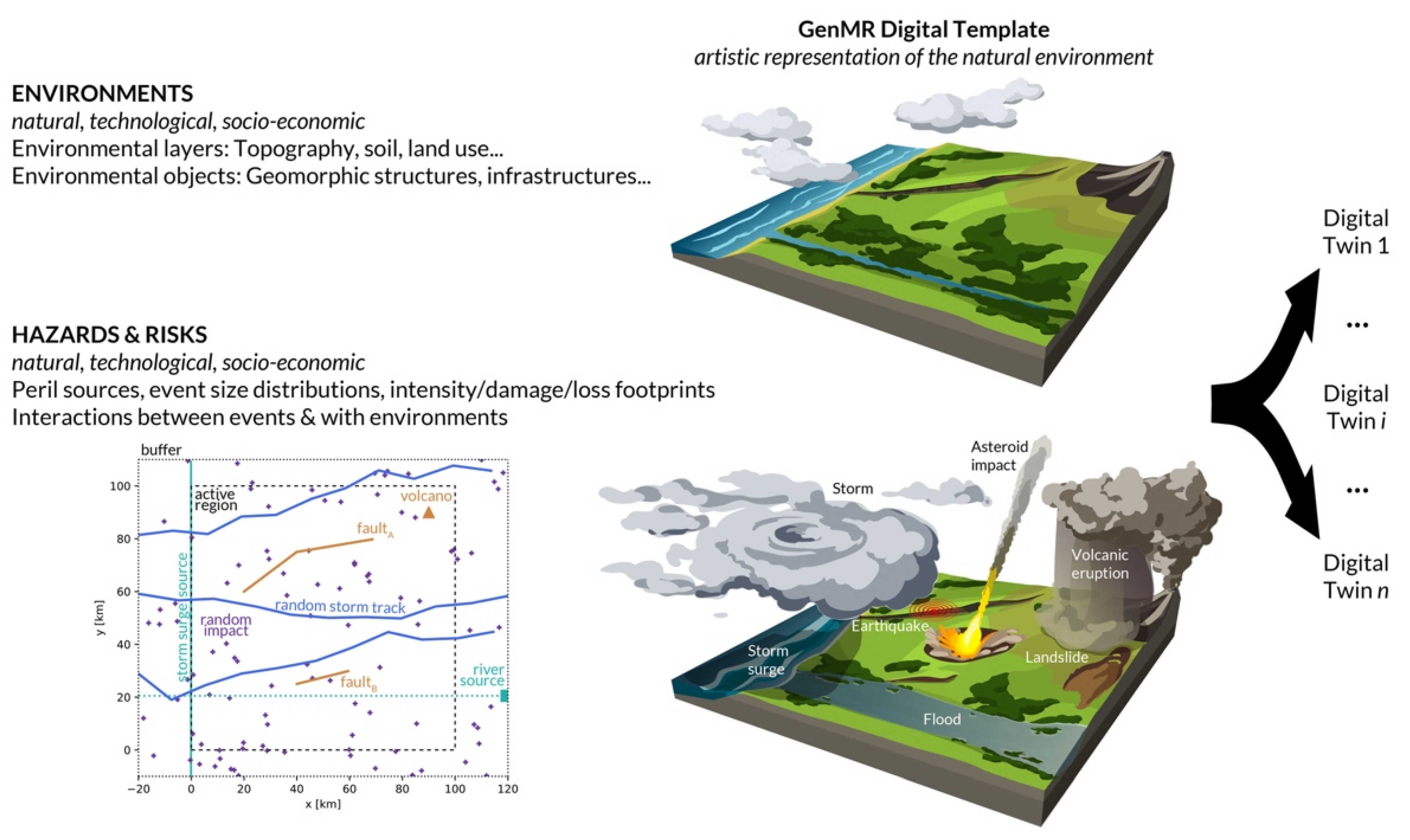
A Digital Template for the Generic Multi-Risk (GenMR) Framework: A Virtual Natural Environment


Abstract
:
1. Introduction
2. Methods
2.1. Natural Environment Definition
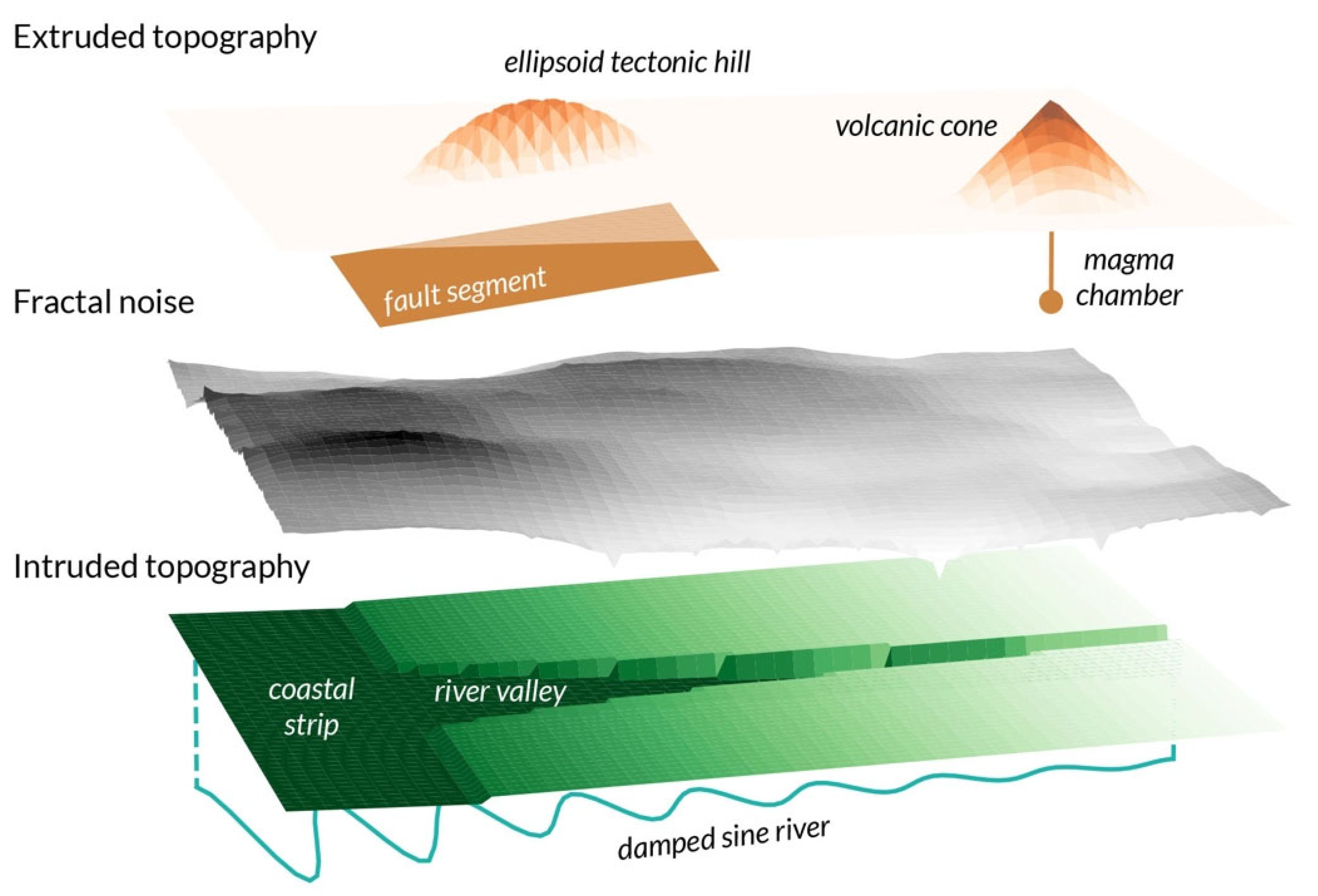
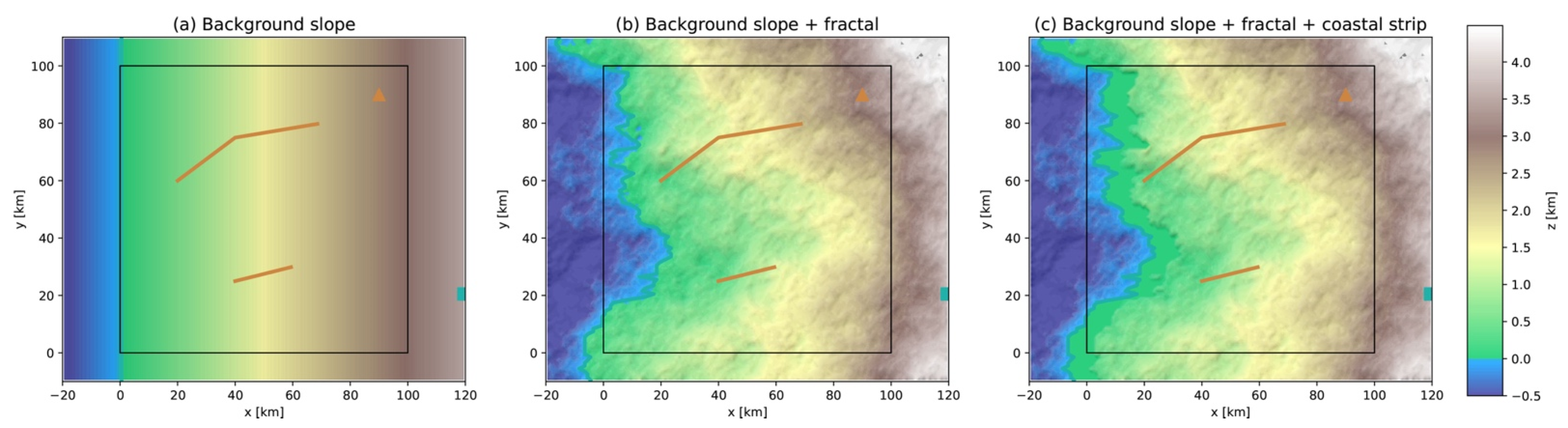
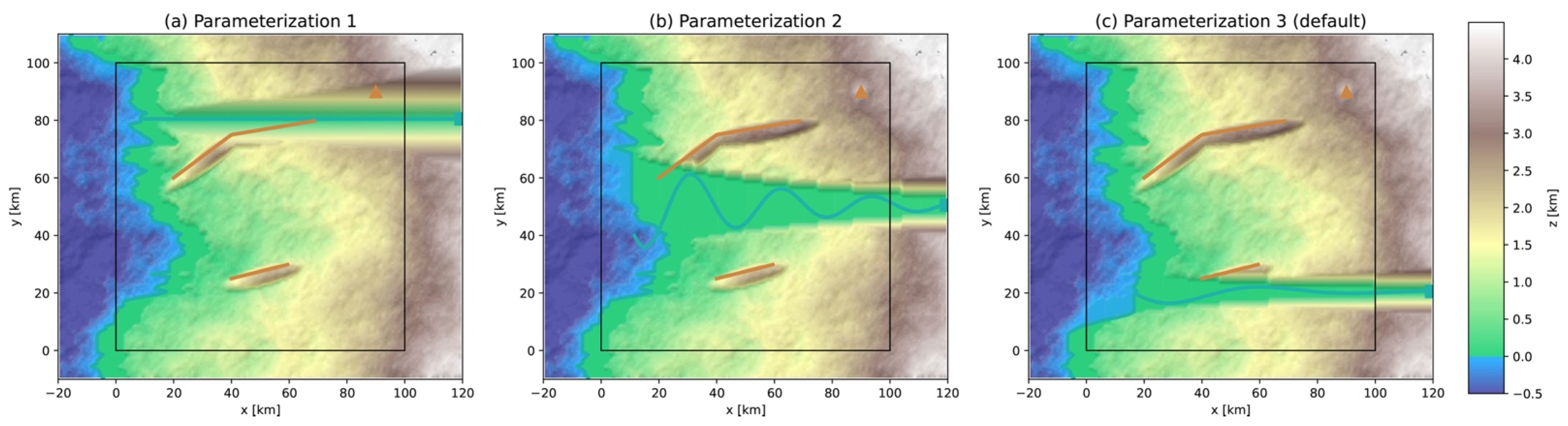
2.1.1. Environmental Layer 1: Topography
- Background slope (Figure 3a): A plane is defined, tilted westward with slope and altitude (by convention to delimitate the coastline). The slope tangent is here fixed to so that the background altitude increases to 3000 m at the eastern boundary of the active region km. Such a slope is characteristic of coastal mountains. Using a much smaller slope would be characteristic of a coastal plain.
2.1.2. Environmental Objects Linked to Geological Perils
2.1.3. Environmental Objects Linked to Hydrological Perils
2.1.4. Environmental Layer 2: Soil
2.2. Hazard Intensity Footprint Modeling
2.2.1. Analytical Expressions of Static Event Spatial Diffusion
2.2.2. Threshold Models of Passive Event Emergence
2.2.3. Numerical Models of Dynamic Event Propagation
- Define the absolute height (or motion cost) as the sum of the altitude and water height ;
- Calculate the gradient (or weight) between the central cell and von Neumann neighbor cells (zero weight for neighbors with equal or greater );
- Discharge the central cell with (some of) the water distributed to the neighbor cells, depending on their weight.
3. Results
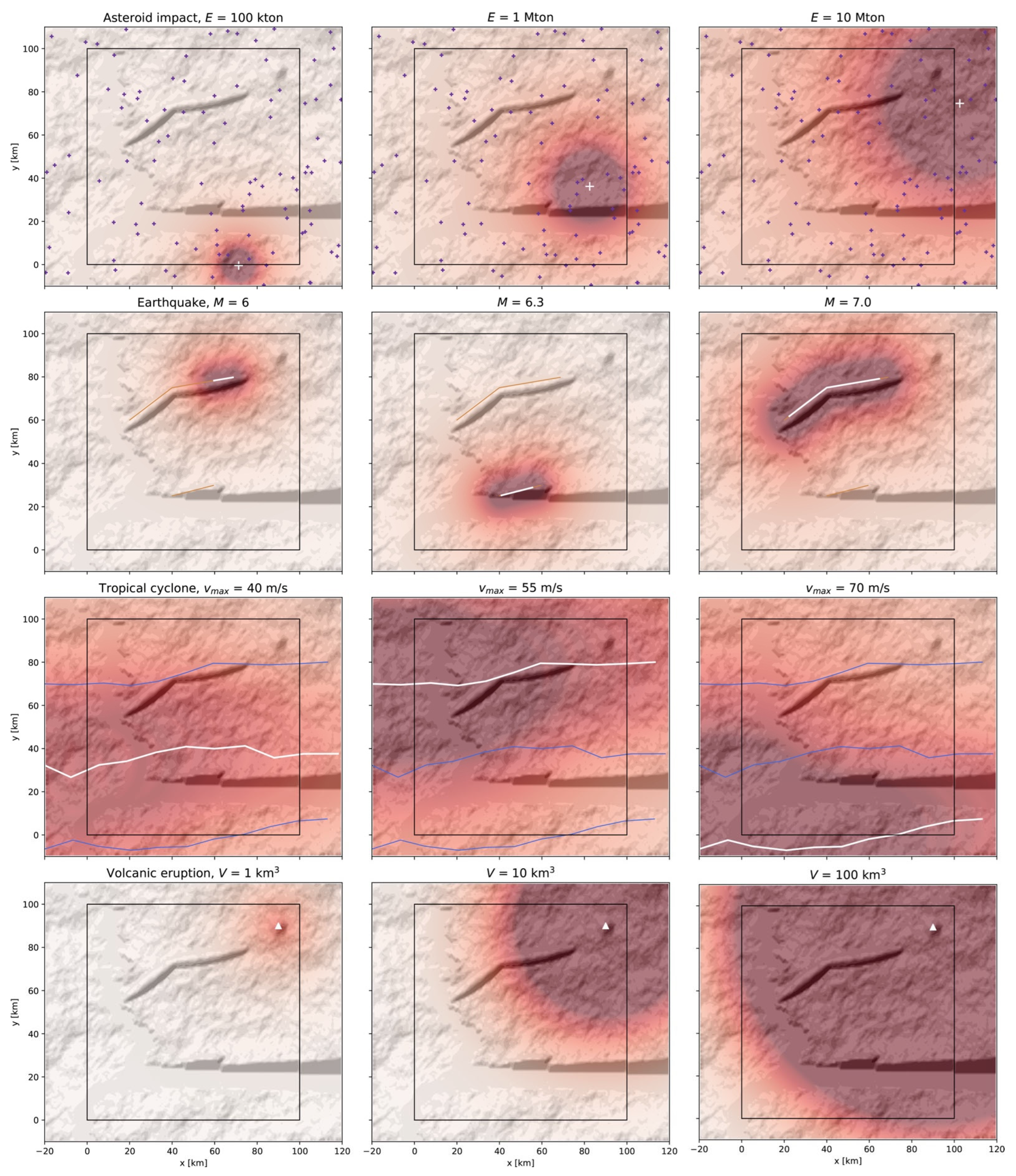
3.1. Intensity Footprints of Primary Perils, Here Independent of the Environmental Layers
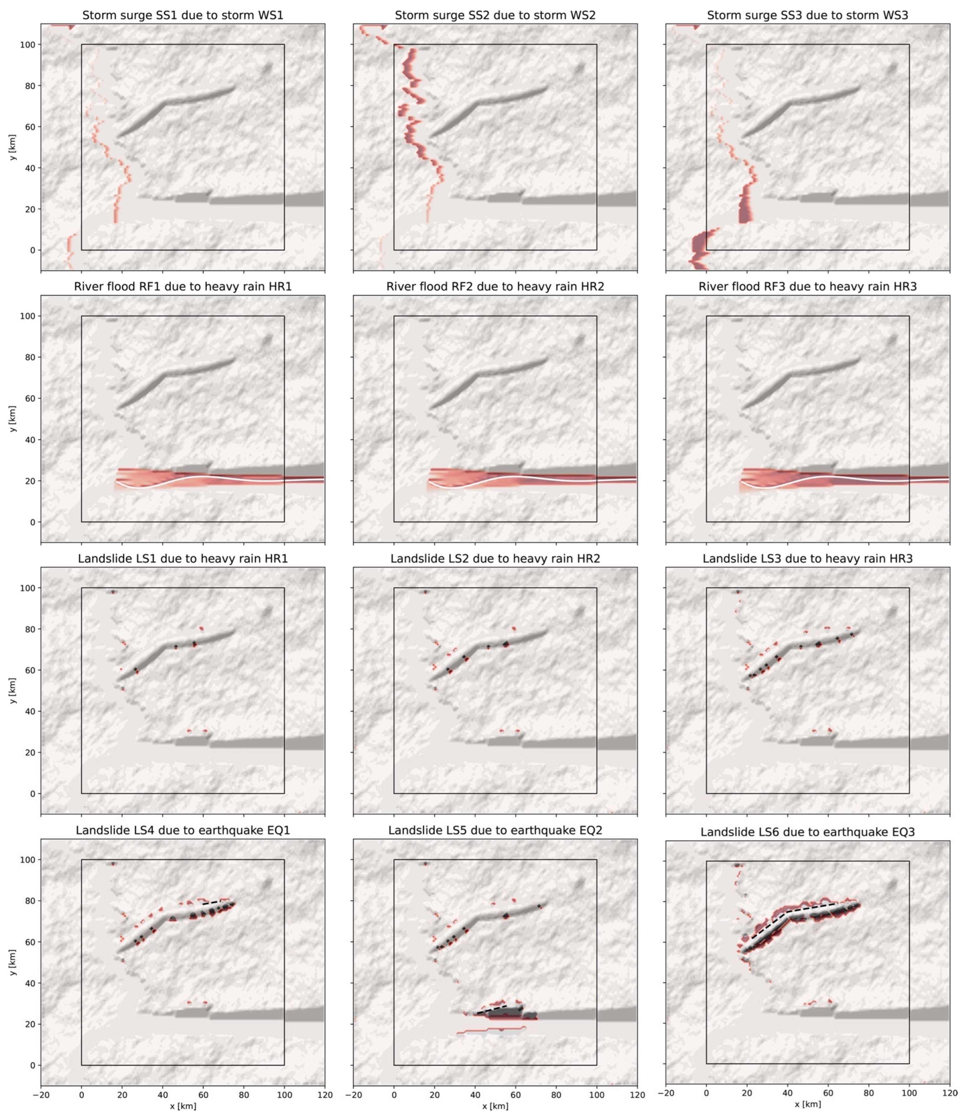
3.2. Intensity Footprints of Secondary Perils, Here Dependent of the Environmental Layers
4. Discussion
5. Conclusions
Funding
Data Availability Statement
Acknowledgments
Conflicts of Interest
Appendix A

| Color | Category | Perils |
|---|---|---|
 | Extraterrestrial | Asteroid impact |
 | Geophysical | Earthquake, landslide, volcanic eruption |
 | Hydrological | River flood, storm surge |
 | Meteorological | Tropical cyclone |
| Parameter | Value | Description |
|---|---|---|
| Active box boundaries [km] | ||
| Buffer box boundaries [km] | ||
| 1 | Grid cell size [km] | |
| Fault segment label (reverse only) | ||
| Fault segment width [km] | ||
| (45,45) | Fault segment dip [°] | |
| Abscissas of fault segment tips [km] | ||
| Ordinates of fault segment tips [km] | ||
| Fault segment depth [km] | ||
| River flood source coordinates [km] | ||
| Upstream catchment basin area [km2] | ||
| Volcano coordinates [km] | ||
| Abscissa of storm track start (ordinate random uniform in range ) | ||
| Number of points along storm track | ||
| Standard deviation of track segment length (total length normalized to ) | ||
| Standard deviation of angle between W-E line and track segment | ||
| 2 | Holland parameter (tropical cyclone) | |
| 17 | Forward velocity of storm [km/h] |
| Parameter | Value | Description |
|---|---|---|
| Altitude of background topography at [km] | ||
| Slope tangent of the background topography [1] | ||
| Slope tangent of the coastal strip [1] | ||
| Width of the coastal strip [km] | ||
| Fractal dimension of the topography [1] | ||
| Ratio of maximum fractal altitude to maximum background altitude [1] | ||
| User-defined vertical shift of the hill ellipsoid centroid [km] | ||
| Width of the volcanic edifice’s cone [km] | ||
| Height of the volcanic edifice’s cone [km] | ||
| River damped sine wave’s initial amplitude [km] | ||
| River damped sine wave’s decay constant [1] | ||
| River damped sine wave’s angular frequency [1] | ||
| Slope tangent of the W-E river [1] | ||
| Slope tangent of the N-S river valley intrusion [1] | ||
| River normal discharge [m3/s] | ||
| Initial soil depth [m] | ||
| Soil background wetness [1] | ||
| Soil effective cohesion [Pa] | ||
| Soil effective friction angle [°] | ||
| Soil density [kg/m3] |
References
- Kappes, M.S.; Keiler, M.; von Elverfeldt, K.; Glade, T. Challenges of analyzing multi-hazard risk: A review. Nat. Hazards 2012, 64, 1925–1958. [Google Scholar] [CrossRef] [Green Version]
- Gill, J.C.; Malamud, B.D. Reviewing and visualizing the interactions of natural hazards. Rev. Geophys. 2014, 52, 680–722. [Google Scholar] [CrossRef] [Green Version]
- Komendantova, N.; Mrzyglocki, R.; Mignan, A.; Khazai, B.; Wenzel, F.; Patt, A.; Fleming, K. Multi-hazard and multi-risk decision-support tools as a part of participatory risk governance: Feedback from civil protection stakeholders. Int. J. Disaster Risk Reduct. 2014, 8, 50–67. [Google Scholar] [CrossRef] [Green Version]
- Gallina, V.; Torresan, S.; Critto, A.; Sperotto, A.; Glade, T.; Marcomini, A. A review of multi-risk methodologies for natural hazards: Consequences and challenges for a climate change impact assessment. J. Environ. Manag. 2016, 168, 123–132. [Google Scholar] [CrossRef]
- Mignan, A.; Komendantova, N.; Scolobig, A.; Fleming, K. Multi-Risk Assessment and Governance. In Handbook of Disaster Risk Reduction & Management; Madu, C.N., Kuei, C.-H., Eds.; World Scientific Publishing: Singapore, 2017; Chapter 14; pp. 357–381. [Google Scholar]
- Hallegatte, S. An Adaptive Regional Input-Output Model and its Application to the Assessment of the Economic Cost of Katrina. Risk Anal. 2008, 28, 779–799. [Google Scholar] [CrossRef]
- Wu, J.; Li, N.; Hallegatte, S.; Shi, P.; Hu, A.; Liu, X. Regional indirect economic impact evaluation of the 2008 Wenchuan Earthquake. Environ. Earth Sci. 2012, 65, 161–172. [Google Scholar] [CrossRef]
- Lund, K.A.; Benediktsson, K. Inhabiting a risky earth, the Eyjafjallajökull eruption in 2010 and its impacts. Anthropol. Today 2011, 27, 6–9. [Google Scholar] [CrossRef]
- Norio, O.; Ye, T.; Kajitani, Y.; Shi, P.; Tatano, H. The 2011 Eastern Japan Great Earthquake Disaster: Overview and Comments. Int. J. Disaster Risk Sci. 2011, 2, 34–42. [Google Scholar] [CrossRef] [Green Version]
- Kunz, M.; Mühr, B.; Kunz-Plapp, T.; Daniell, J.E.; Khazai, B.; Wenzel, F.; Vannieuwenhuyse, M.; Comes, T.; Elmer, F.; Schröter, K.; et al. Investigation of superstorm Sandy 2012 in a multi-disciplinary approach. Nat. Hazards Earth Syst. Sci. 2013, 13, 2579–2598. [Google Scholar] [CrossRef] [Green Version]
- Gori, A.; Gidaris, I.; Elliott, J.R.; Padgett, J.; Loughran, K.; Bedient, P.; Panakkal, P.; Juan, A. Accessibility and Recovery Assessment of Houston’s Roadway Network due to Fluvial Flooding during Hurricane Harvey. Nat. Hazards Rev. 2020, 21, 04020005. [Google Scholar] [CrossRef]
- Lenzen, M.; Li, M.; Malik, A.; Pomponi, F.; Sun, Y.-Y.; Wiedmann, T.; Faturay, F.; Fry, J.; Gallego, B.; Geschke, A.; et al. Global socio-economic losses and environmental gains from the Coronavirus pandemic. PLoS ONE 2020, 15, e0235654. [Google Scholar] [CrossRef] [PubMed]
- Mitchell-Wallace, K.; Jones, M.; Hillier, J.; Foote, M. Natural Catastrophe Risk Management and Modelling, A Practitioner’s Guide; John Wiley & Sons Ltd.: Chichester, UK, 2017. [Google Scholar]
- Cui, P.; Zhu, Y.-Y.; Han, Y.-S.; Chen, X.-Q.; Zhuang, J.-Q. The 12 May Wenchuan earthquake-induced landslide lakes: Distribution and preliminary risk evaluation. Landslides 2009, 6, 209–223. [Google Scholar] [CrossRef]
- Devanandham, H.; Raminez-Marquez, J.E. On the Impacts of Power Outages during Hurricane Sandy—A Resilience-Based Analysis. Syst. Eng. 2016, 19, 59–75. [Google Scholar]
- Xu, J.; Wang, Z.; Shen, F.; Ouyang, C.; Tu, Y. Natural disasters and social conflict: A systematic literature review. Int. J. Disaster Risk Reduct. 2016, 17, 38–48. [Google Scholar] [CrossRef]
- Selva, J.; Acocella, V.; Bisson, M.; Caliro, S.; Costa, A.; Della Seta, M.; De Martino, P.; de Vita, S.; Federico, C.; Giordano, G.; et al. Multiple natural hazards at volcanic islands: A review for the Ischia volcano (Italy). J. Appl. Volcanol. 2019, 8, 5. [Google Scholar] [CrossRef] [Green Version]
- Tang, P.; Xia, Q.; Wang, Y. Addressing cascading effects of earthquakes in urban areas from network perspective to improve disaster mitigation. Int. J. Disaster Risk Reduct. 2019, 35, 101065. [Google Scholar] [CrossRef]
- Marzocchi, W.; Garcia-Aristizabal, A.; Gasparini, P.; Mastellone, M.L.; Di Ruocco, A. Basic principles of multi-risk assessment: A case study in Italy. Nat. Hazards 2012, 62, 551–573. [Google Scholar] [CrossRef]
- Liu, Z.; Nadim, F.; Garcia-Aristizabal, A.; Mignan, A.; Fleming, K.; Luna, B.Q. A three-level framework for multi-risk assessment. Georisk Assess. Manag. Risk Eng. Syst. Geohazards 2015, 9, 59–74. [Google Scholar] [CrossRef] [Green Version]
- Hackl, J.; Lam, J.C.; Heitzler, M.; Adey, B.T.; Hurni, L. Estimating network related risks: A methodology and an application in the transport sector. Nat. Hazards Earth Syst. Sci. 2018, 18, 2273–2293. [Google Scholar] [CrossRef] [Green Version]
- Paulik, R.; Horspool, N.; Woods, R.; Griffiths, N.; Beale, T.; Magill, C.; Wild, A.; Popovich, B.; Walbran, G.; Garlick, R. RiskScape: A flexible multi-hazard risk modelling engine. Nat. Hazards 2022. [Google Scholar] [CrossRef]
- De Angeli, S.; Malamud, B.D.; Rossi, L.; Taylor, F.E.; Trasforini, E.; Rudari, R. A multi-hazard framework for spatial-temporal impact analysis. Int. J. Disaster Risk Reduct. 2022, 73, 102829. [Google Scholar] [CrossRef]
- Mignan, A.; Scolobig, A.; Sauron, A. Using reasoned imagination to learn about cascading hazards: A pilot study. Disaster Prev. Manag. 2016, 25, 329–344. [Google Scholar] [CrossRef] [Green Version]
- Mignan, A.; Wang, Z. Exploring the Space of Possibilities in Cascading Disasters with Catastrophe Dynamics. Int. J. Environ. Res. Public Health 2020, 17, 7317. [Google Scholar] [CrossRef] [PubMed]
- Mignan, A.; Wiemer, S.; Giardini, D. The quantification of low-probability-high-consequences events: Part I. A generic multi-risk approach. Nat. Hazards 2014, 73, 1999–2022. [Google Scholar] [CrossRef] [Green Version]
- Mignan, A.; Danciu, L.; Giardini, D. Considering large earthquake clustering in seismic risk analysis. Nat. Hazards 2018, 91, 149–172. [Google Scholar] [CrossRef] [Green Version]
- Matos, J.; Mignan, A.; Schleiss, A. Vulnerability of large dams considering hazard interactions: Conceptual application of the Generic Multi-Risk framework. In Proceedings of the 13th ICOLD Benchmark Workshop on the Numerical Analysis of Dams, Lausanne, Switzerland, 9–11 September 2015; pp. 285–292. [Google Scholar]
- Mignan, A.; Spada, M.; Burgherr, P.; Wang, Z.; Sornette, D. Dynamics of severe accidents in the oil & gas energy sector derived from the authoritative Energy-related Severe Accident database. PLoS ONE 2022, 17, e0263962. [Google Scholar]
- Mignan, A.; Mochel, L.; Ducos, G. Involving Risk Reduction Practitioners and Other Experts in the Management of Super-Catastrophes via on Online Interactive Platform. Front. Earth Sci. 2022, 10, 829145. [Google Scholar] [CrossRef]
- Scolobig, A.; Komendantova, N.; Mignan, A. Mainstreaming Multi-Risk Approaches into Policy. Geosciences 2017, 7, 129. [Google Scholar] [CrossRef] [Green Version]
- Mignan, A. Categorizing and Harmonizing Natural, Technological, and Socio-Economic Perils Following the Catastrophe Modeling Paradigm. Int. J. Environ. Res. Public Health 2022, 19, 12780. [Google Scholar] [CrossRef]
- Boschert, S.; Rosen, R. Digital Twin—The Simulation Aspect. In Mechatronic Futures; Hehenberger, P., Bradley, D., Eds.; Springer International Publishing: Cham, Switzerland, 2016; Chapter 5; pp. 59–74. [Google Scholar]
- Grieves, M.; Vickers, J. Digital Twin: Mitigating Unpredictable, Undesirable Emergent Behavior in Complex Systems. In Transdisciplinary Perspectives on Complex Systems; Kahlen, F.-J., Flumerfelt, S., Alves, A., Eds.; Springer International Publishing: Cham, Switzerland, 2017; pp. 85–113. [Google Scholar]
- Fan, C.; Zhang, C.; Yahja, A.; Mostafavi, A. Disaster City Digital Twin: A vision for integrating artificial and human intelligence for disaster management. Int. J. Inf. Manag. 2021, 56, 102049. [Google Scholar] [CrossRef]
- Requicha, A.G. Representations for Rigid Solids: Theory, Methods, and Systems. ACM Comput. Surv. 1980, 12, 437–464. [Google Scholar] [CrossRef]
- Verecchia, E.P. Foreword: Image Analysis and Morphometry of Geological Objects. Math. Geol. 2003, 35, 759–762. [Google Scholar] [CrossRef]
- Fournier, A.; Fussell, D.; Carpenter, L. Computer Rendering of Stochastic Models. Commun. ACM 1982, 25, 371–384. [Google Scholar] [CrossRef]
- Xu, T.; Moore, I.D.; Gallant, J.C. Fractals, fractal dimensions and landscapes—A review. Geomorphology 1993, 8, 245–262. [Google Scholar] [CrossRef]
- Athanasiou, P.; van Dongeren, A.; Giardino, A.; Vousdoukas, M.; Gaytan-Aguilar, S.; Ranasinghe, R. Global distribution of nearshore slopes with implications for coastal retreat. Earth Syst. Sci. Data 2019, 11, 1515–1529. [Google Scholar] [CrossRef] [Green Version]
- Rodríguez, C.E.; Bommer, J.J.; Chandler, R.J. Earthquake-induced landslides: 1980–1997. Soil Dyn. Earthq. Eng. 1999, 18, 325–346. [Google Scholar] [CrossRef]
- Thannoun, R.G.; Fanoosh, S.A.; Adeeb, H.G.M. Integration of satellite data processing with seismic sections for tectonic interpretation and modeling for the breaks and omissions of continuous stratigraphic units. Int. Rev. Appl. Sci. Eng. 2021, 12, 34–43. [Google Scholar] [CrossRef]
- Grosse, P.; Euillades, P.A.; Euillades, L.D.; van Wyk de Vries, B. A global database of composite volcano morphometry. Bull. Volcanol. 2014, 76, 784. [Google Scholar] [CrossRef]
- Montgomery, D.R. Slope Distributions, Threshold Hillslopes, and Steady-State Topography. Am. J. Sci. 2001, 301, 432–454. [Google Scholar] [CrossRef] [Green Version]
- Pack, R.T.; Tarboton, D.G.; Goodwin, C.N. The SINMAP Approach to Terrain Stability Mapping. In Proceedings of the 8th Congress of the International Association of Engineering Geology, Vancouver, BC, Canada, 21 September 1998. [Google Scholar]
- Pelletier, J.D.; Broxton, P.D.; Hazenberg, P.; Zeng, X.; Troch, P.A.; Niu, G.-Y.; Williams, Z.; Brunke, M.A.; Gochis, D. A gridded global data set of soil, immobile regolith, and sedimentary deposit thickness for regional and global land surface modeling. J. Adv. Model. Earth Syst. 2016, 8, 41–65. [Google Scholar] [CrossRef]
- Mills, C. The design of concrete structures to resist explosions and weapon effects. In Proceedings of the 1st International Conference on Concrete for Hazard Protections, Edinburgh, UK, 27–30 September 1987. [Google Scholar]
- Mignan, A.; Grossi, P.; Muir-Wood, R. Risk assessment of Tunguska-type airbursts. Nat. Hazards 2011, 56, 869–880. [Google Scholar] [CrossRef] [Green Version]
- Mathias, D.L.; Wheeler, L.F.; Dotson, J.L. A probabilistic asteroid impact risk model: Assessment of sub-300 m impacts. Icarus 2017, 289, 106–119. [Google Scholar] [CrossRef]
- Akkar, S.; Bommer, J.J. Empirical Equations for the Prediction of PGA, PGV, and Spectral Accelerations in Europe, the Mediterranean Region, and the Middle East. Seism. Res. Lett. 2010, 81, 195–206. [Google Scholar] [CrossRef] [Green Version]
- Wells, D.L.; Coppersmith, K.J. New Empirical Relationships among Magnitude, Rupture Length, Rupture Width, Rupture Area, and Surface Displacement. Bull. Seism. Soc. Am. 1994, 84, 974–1002. [Google Scholar]
- Pyle, D.M. The Thickness, volume and grainsize of tephra fall deposits. Bull. Volcanol. 1989, 51, 1–15. [Google Scholar] [CrossRef]
- Holland, G.J. An Analytic Model of the Wind and Pressure Profiles in Hurricanes. Mon. Weather Rev. 1982, 108, 1212–1218. [Google Scholar] [CrossRef]
- Fang, P.; Ye, G.; Yu, H. A parametric wind field model and its application in simulating historical typhoons in the western North Pacific Ocean. J. Wind Eng. Ind. Aerodyn. 2020, 199, 104131. [Google Scholar] [CrossRef]
- Kaplan, J.; DeMaria, M. A Simple Empirical Model for Predicting the Decay of Tropical Cyclone Winds after Landfall. J. Appl. Meteorol 1995, 34, 2499–2512. [Google Scholar] [CrossRef]
- Ramirez, J.A.; Lichter, M.; Coulthard, T.J.; Skinner, C. Hyper-resolution mapping of regional storm surge and tide flooding: Comparison of static and dynamic models. Nat. Hazards 2016, 82, 571–590. [Google Scholar] [CrossRef]
- Muir-Wood, R.; Drayton, M.; Berger, A.; Burgess, P.; Wright, T. Catastrophe loss modelling of storm-surge flood risk in eastern England. Philos Trans. R. Soc. A 2005, 363, 1407–1422. [Google Scholar] [CrossRef]
- Lin, N.; Emanuel, K.A.; Smith, J.A.; Vanmarcke, E. Risk assessment of hurricane storm surge for New York City. J. Geophys. Res. 2010, 115, D18121. [Google Scholar] [CrossRef] [Green Version]
- Bak, P.; Tang, C.; Wiesenfeld, K. Self-Organized Criticality: An Explanation of 1/f Noise. Phys. Rev. Lett. 1987, 59, 381–384. [Google Scholar] [CrossRef] [PubMed]
- Newmark, N.M. Effects of Earthquakes on Dams and Embankments. Geotechnique 1965, 15, 139–159. [Google Scholar] [CrossRef]
- Jibson, R.W. Predicting Earthquake-Induced Landslide Displacements Using Newmark’s Sliding Block Analysis. Transp. Res. Rec. 1993, 1411, 9–17. [Google Scholar]
- Issermann, M.; Chang, F.-J.; Jia, H. Efficient Urban Inundation Model for Live Flood Forecasting with Cellular Automata and Motion Cost Fields. Water 2020, 12, 1997. [Google Scholar] [CrossRef]
- Popova, O.P.; Jenniskens, P.; Emel’yanenko, V.; Kartashova, A.; Biryukov, E.; Khaibrakhmanov, S.; Shuvalov, V.; Rybnov, Y.; Dudorov, A.; Grokhovsky, V.I.; et al. Chelyabinsk Airburst, Damage Assessment, Meteorite Recovery, and Characterization. Science 2013, 342, 1069–1073. [Google Scholar] [CrossRef] [PubMed] [Green Version]
- Mignan, A.; Danciu, L.; Giardini, D. Reassessment of the Maximum Fault Rupture Length of Strike-Slip Earthquakes and Inference on Mmax in the Anatolian Peninsula, Turkey. Seism. Res. Lett. 2015, 86, 890–900. [Google Scholar] [CrossRef]
- Starr, P. Seductions of Sim: Policy as a simulation game. Am. Prospect 1994, 5, 19–29. [Google Scholar]
- Friedman, T. The Semiotics of SimCity. First Monday 1999, 4. [Google Scholar] [CrossRef]
- Micropolis. Available online: https://github.com/SimHacker/micropolis (accessed on 30 October 2022).
- Earle, S. Using Fractal Neural Networks to Play SimCity 1 and Conway’s Game of Life at Variable Scales. arXiv 2020, arXiv:2002.03896. [Google Scholar] [CrossRef]
- Urban Renewal, Cities: Skylines by Colossal Order. Available online: https://unity.com/case-study/cities-skylines (accessed on 29 October 2022).
- White, G.; Zink, A.; Codecá, L.; Clarke, S. A Digital Twin Smart City for Citizen Feedback. Cities 2021, 110, 103064. [Google Scholar] [CrossRef]
- Gampell, A.; Gaillard, J.C.; Parsons, M.; Le Dé, L. ‘Serious’ Disaster Video Games: An Innovative Approach to Teaching and Learning about Disaster Risk Reduction. J. Geogr. 2020, 119, 159–170. [Google Scholar] [CrossRef]
- Pereira, G.; Prada, R.; Paiva, A. Disaster Prevention Social Awareness: The Stop Disasters! Case Study. In Proceedings of the 6th International Conference on Games and Virtual Worlds for Serious Applications, Valletta, Malta, 9–12 September 2014. [Google Scholar]
- Olszewski, R.; Cegielka, M.; Szczepankowska, U.; Wesolowski, J. Developing a Serious Game That Supports the Resolution of Social and Ecological Problems in the Toolset Environment of Cities: Skylines. Int. J. Geo Inf. 2020, 9, 118. [Google Scholar] [CrossRef] [Green Version]
- Devisch, O. Should Planners Start Playing Computer Games? Arguments from SimCity and Second Life. Plan. Theory Pract. 2008, 9, 209–226. [Google Scholar] [CrossRef] [Green Version]
- Pitilakis, K.; Riga, E.; Anastasiadis, A. New code site classification, amplification factors and normalized response spectra based on a worldwide ground-motion database. Bull. Earthq. Eng. 2013, 11, 925–966. [Google Scholar] [CrossRef]
- Zhu, P. Impact of land-surface roughness on surface winds during hurricane landfall. Q. J. R. Meteorol. Soc. 2008, 134, 1051–1057. [Google Scholar] [CrossRef]
- Sheng, Y.P.; Lapetina, A.; Ma, G. The reduction of storm surge by vegetation canopies: Three-dimensional simulations. Geophys. Res. Lett. 2012, 39, L20601. [Google Scholar] [CrossRef] [Green Version]
- White, R.; Engelen, G.; Uljee, I. The use of constrained cellular automata for high-resolution modelling of urban land-use dynamics. Environ. Plan. B Plan. Des. 1997, 24, 323–343. [Google Scholar] [CrossRef]
- Clarke, K.C.; Hoppen, S.; Gaydos, L. A self-modifying cellular automaton model of historical urbanization in the San Francisco Bay area. Environ. Plan. B Plan. Des. 1997, 24, 247–261. [Google Scholar] [CrossRef] [Green Version]
- Samaniego, H.; Moses, M.E. Cities as organisms: Allometric scaling of urban road networks. J. Transp. Land Use 2008, 1, 21–39. [Google Scholar] [CrossRef] [Green Version]
- Fan, J.; Meng, J.; Ludescher, J.; Chen, X.; Ashkenazy, Y.; Kurths, J.; Havlin, S.; Schellnhuber, H.J. Statistical physics approaches to the complex Earth system. Phys. Rep. 2021, 896, 1–84. [Google Scholar] [CrossRef] [PubMed]


| Peril ID | Peril Name | Source | Source Type * | Related Object |
|---|---|---|---|---|
| AI | Asteroid impact | Impact site | Point | N/A |
| EQ | Earthquake | Fault segment | Line | Tectonic hill |
| LS | Landslide | Topography | Diffuse | N/A |
| RF | River flood | Upriver point | Point | River valley |
| SS | Storm surge | Coastline | Line | Coastal strip |
| VE | Volcanic eruption | Volcano | Point | Volcanic edifice |
| WS | Windstorm | Depression | Track | N/A |
Publisher’s Note: MDPI stays neutral with regard to jurisdictional claims in published maps and institutional affiliations. |
© 2022 by the author. Licensee MDPI, Basel, Switzerland. This article is an open access article distributed under the terms and conditions of the Creative Commons Attribution (CC BY) license (https://creativecommons.org/licenses/by/4.0/).
Share and Cite
Mignan, A. A Digital Template for the Generic Multi-Risk (GenMR) Framework: A Virtual Natural Environment. Int. J. Environ. Res. Public Health 2022, 19, 16097. https://doi.org/10.3390/ijerph192316097
Mignan A. A Digital Template for the Generic Multi-Risk (GenMR) Framework: A Virtual Natural Environment. International Journal of Environmental Research and Public Health. 2022; 19(23):16097. https://doi.org/10.3390/ijerph192316097
Chicago/Turabian StyleMignan, Arnaud. 2022. "A Digital Template for the Generic Multi-Risk (GenMR) Framework: A Virtual Natural Environment" International Journal of Environmental Research and Public Health 19, no. 23: 16097. https://doi.org/10.3390/ijerph192316097