3.1. Sample Characterization
Summary statistics for total Cu and Pb contents are provided in
Table 1. In the study area, the estimated concentrations of Cu were much higher than the average Chinese soil background value of 20.7 mg/kg [
9].
Table 1.
Characteristics of total Cu and Pb contents in the soil sample set (n = 71).
Table 1.
Characteristics of total Cu and Pb contents in the soil sample set (n = 71).
| Heavy metal | Min | Max | Mean | Median | Standard deviation | China soil background value [9] |
|---|
| Total Cu content (mg/kg) | 90 | 3,034 | 290 | 126 | 470 | 20.7 |
| Total Pb content (mg/kg) | 29 | 605 | 90 | 74 | 82 | 23.5 |
The value was also higher than the suggested local background value (48 mg/kg for non-agricultural top soil and 51 mg/kg for agricultural top soil) from a contemporary geochemical survey in the Dexing area, where 53 samples of our study were collected [
10]. The distribution of the sampling sites might explain part of this difference as most sample sites in our study were located along the river, and therefore easily influenced by floods carrying heavy metals. Study carried out in nonferric metal mining area in surface soils in some countries reported comparable copper content, e.g., in Japan (456–2,020 mg/kg) [
11]. The lead content (
Table 1) was below the average contamination level in nonferric metal mining area in the Great Britain (170–4,563 mg/kg) [
12], the U.S. (15–13,000 mg/kg) [
13], and the Germany (>300 mg/kg) [
14].
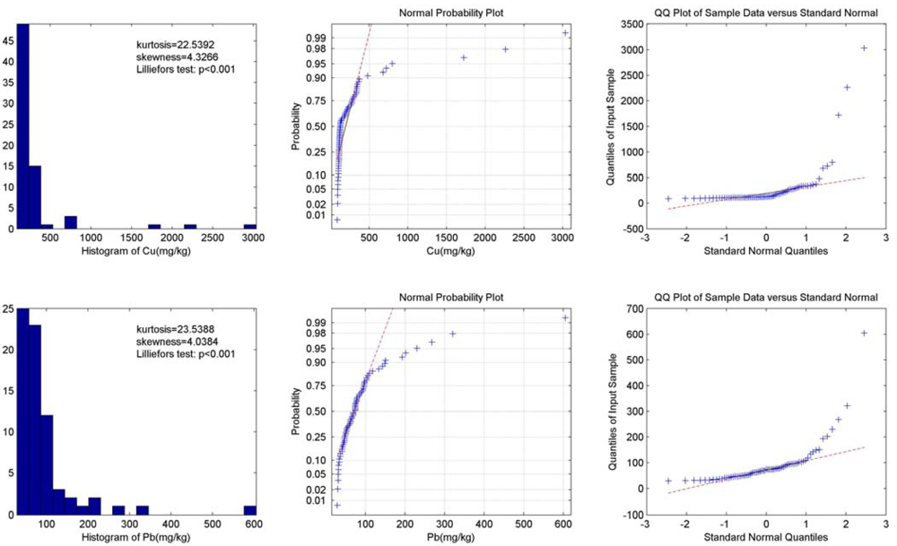
The histogram, normal probability plot and Q-Q plot of total Cu and Pb contents are shown in
Figure 4. Graphical inspections of both the total Cu and Pb contents show that the data is highly positively skewed (skewness = 4.33 and 4.04, respectively) and asymmetrical with a steep peak (kurtosis = 22.54 and 23.54, respectively). The Lilliefors normality test, normal probability plot and Q-Q plot show evidence of non-normality. The histogram also suggests that there are some samples with extreme values. Therefore, the Krigking interpolation strategies were not used in this study for their normality assumption.
Figure 4.
Data distribution and normality test results of total Cu and Pb content.
Figure 4.
Data distribution and normality test results of total Cu and Pb content.
3.2. Mapping the Total Cu and Pb Contents
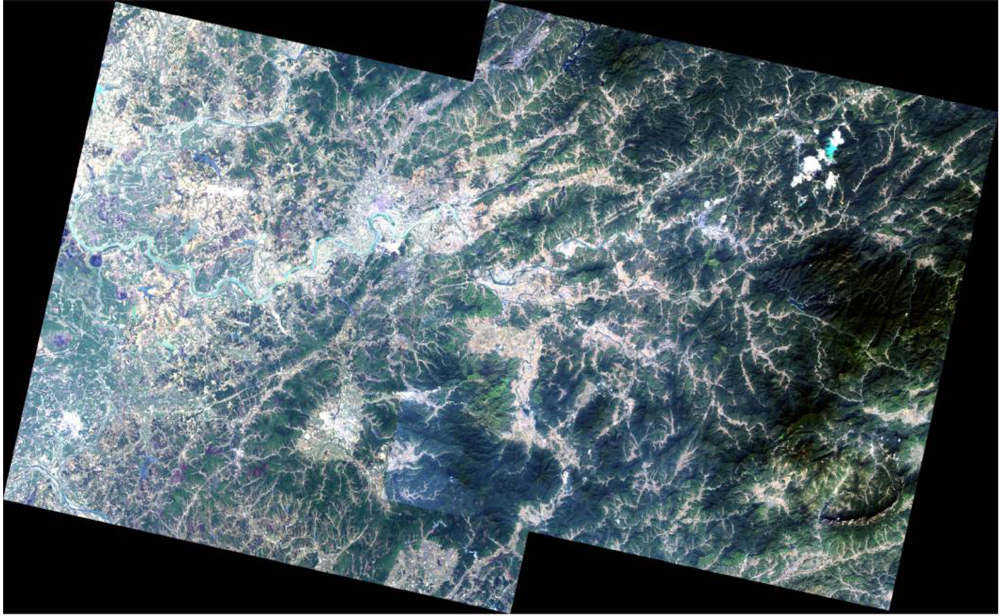
Two series of maps derived from an integration of multiple data sources are presented below to show the spatial distribution pattern of total Cu and Pb in the soil along the Le’an River. In these maps, color scales from blue for low concentration of Cu/Pb to red for high Cu/Pb content in soil. Sample sites and cities are also marked with 3D symbols. The estimation of heavy metal contents in area is calculated from point interpolation. Thus, the estimation could be generally more reliable in the area which is closer to sample sites. Interpretation results from Alos images shows the built up area (in grey), agricultural area (in light green), and mining area (in orange). The transparency of the land use type layer was set to 50% for a better visual inspection.
3.3. Source Identification and Analysis
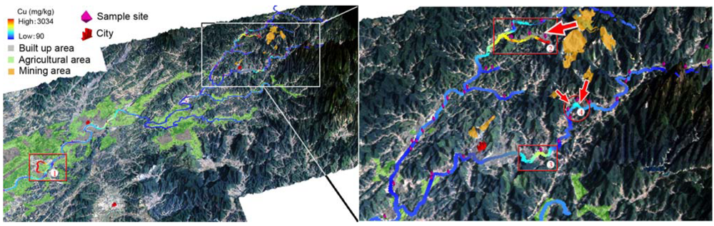
The overall spatial distributions of the total Cu content in the top soil along the Le’an River are shown in the left of
Figure 5. An area with high total Cu content is highlighted by a red rectangle and noted as “①”. The soil sample in this area was taken from the river terrace of a short tributary downstream of the Le’an River in the Raobu County, which has an estimated population of 49 thousands and cultivated land of 20 km
2. The total Cu content reached as high as 2262 mg/kg. An explanation for such a high value could be that the water velocity in this tributary was low. Thus, suspended sediment which was rich in Cu content deposited here. This hypothesis needs to be confirmed with more soil samples collected around this area and with the water velocity measured.
The total Cu content distributions around the Dexing Copper Mine are shown in the right of
Figure 5. Three regions, at least, were rich in total Cu content. They were respectively noted as “②”, “③”, and “④” in the figure.
Figure 5.
Maps showing the distribution of total Cu content in the soil along the Le’an River and its branches (left), and in the soil around mining area (right).
Figure 5.
Maps showing the distribution of total Cu content in the soil along the Le’an River and its branches (left), and in the soil around mining area (right).
Soil samples from the terrace of the region ② (red square), which located at the middle and lower reaches of the Dawu River, showed up with an average of Cu content at about 800 mg/kg. The mining area highlighted in light orange could be the source. The potential transportation route of Cu was suggested with a red arrow. The source and route was thereafter confirmed by flow accumulation analyses. Little agricultural land was found in this area. Thus, the risk of Cu up taken by local residents through food chain could be low. According to our survey, however, significant atmospheric dust arose from the mechanical disturbance. Particulate matters (e.g., PM2.5) from road dust resulting from vehicular traffic needed to be monitored with regular reports published. The use of watering cart (which had been witnessed in this survey) and breathing mask could be helpful for keeping the residents here from potential exposure to pollutants carried by aerosol.
Regions ③ and ④ are located in the middle and lower reaches of the Jishui River (
Figure 5). Possible transportation of total Cu content was marked by red arrows through visual inspections (
Figure 5). With consideration of the topography and the precipitation, the soil downhill in the region ④ might be polluted by pollutants from two mine tailings uphill. A small town named Xinying located in the regions ③, where small and scattered agricultural lands with vegetables grown by local residents were witnessed. These vegetables were growing in polluted soil and thus had potential threats to their consumers. The pollution source might be from the mine tailings upstream. The high level of Cu content could partly be attributed to Cu-rich suspended particles carried by the running water, which deposited and accumulated in this area.
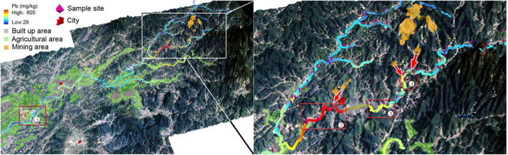
The left of
Figure 6 shows an overall distribution of total Pb content in top soil along the Le’an River and its branches, and the right portion provides details of the total Pb distribution around the Yinshan Lead and Zinc Mine. Four regions with relatively high total Pb content were highlighted by red frame and numbered with “①”, “②”, “③”, and “④”. The concentration of Pb in the region ① reached as high as 230 mg/kg. Considering the high level of Cu content indicated by the same sample collected at this site, further survey should be encouraged to evaluate the soil contamination level in this area.
Figure 6.
Maps showing the distribution of total Pb content in the soil along the Le’an River and its branches (left), and in the soil around mining area (right).
Figure 6.
Maps showing the distribution of total Pb content in the soil along the Le’an River and its branches (left), and in the soil around mining area (right).
The spatial distribution of total Pb content at the middle and upper reaches of the Le’an River is shown in
Figure 6. The soil samples collected along the Jishui River showed up with generally high values in comparisons with those of along the Le’an River. The Pb content of soil samples from around the Dexing City, which was noted as the region ②, ranged from 202 mg/kg to 605 mg/kg. The Yinshan Lead and Zinc Mine was likely the source. The transportation routes were indicated by an arrow. Similarly to the total Cu distribution along the Jishui River, the regions ③ and ④ both showed up with relatively high total Pb content.
3.4. Watershed Delineation
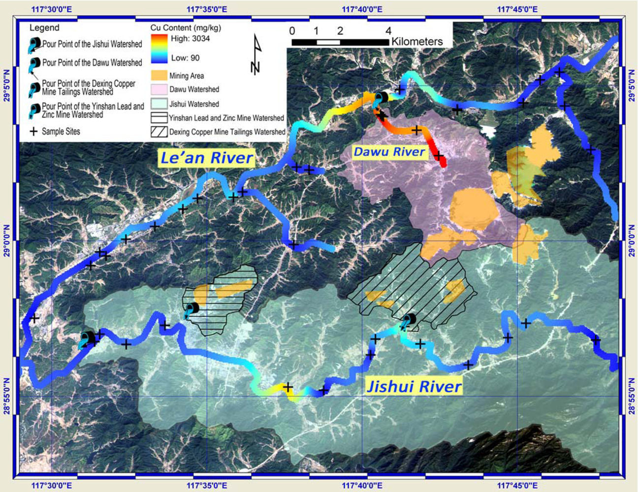
Four watersheds, namely the Jishui watershed, the Dawu watershed, the Dexing Copper Mine Tailings Watershed and the Yinshan Lead and Zinc Mine Water, were extracted and shown with their pour points in
Figure 7 and
Figure 8. The latter two small watersheds are parts of the Jishui watershed. The direction of the arrow in the symbol of the pour point indicates the water flow direction of specific watershed at the pour point. The ALOS remote sensing image serves as background, from which the land use and land cover can be identified. Coupled with Cu/Pb content along rivers, sample sites and vector data highlighting the mining area,
Figure 7 and
Figure 8 provide a visual and comprehensive inspection on the spatial relationships between the polluted sites and the sources. The significant role that topography plays in the transportation of the Cu and Pb was further discussed.
The Dawu watershed covers the major part of the Dexing Copper Mine (
Figure 7). The soil samples along the Dawu River were observed with high content of Cu, whereas the Pb content in these samples was low. The Cu content in the soil samples collected outside this watershed was generally much lower. This indicates that the mining activities in the Dexing Copper Mine significantly increased the total Cu content in the soil along the Dawu River, which was in the Dawu watershed. The soil sample near the pour point of the Dexing Copper Mine tailings watershed showed up with relatively high value of Cu content. The previously proposed explanation for the relatively high Cu value observed in region ④ (in
Section 3.3) can thus be confirmed: Cu element was transported from the two mine tailings.
Figure 7.
Spatial relationships between watersheds, mining area and total Cu content.
Figure 7.
Spatial relationships between watersheds, mining area and total Cu content.
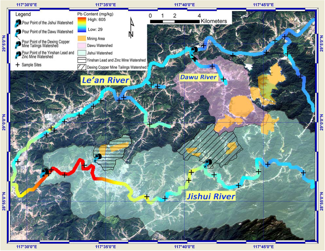
The Jishui River ran from east to west (
Figure 8). The soil samples downstream the Jishui River became to show high value in total Pb content from the pour point of the Yinshan Lead and Zinc Mine watershed. In case of raining, part of rainfall in this watershed became streamflow carrying Pb, and accumulated at the pour point. Considering the high value of Pb content in the samples collected downstream of the pour point, it is feasible to infer that the Yinshan Lead and Zinc Mine was the source of Pb pollution in the soil in this area. As the Dexing City located here, its citizens were in the risk of the Pb pollution in soil. For the soil samples along the Le’an River and its other branches, the Pb content was generally low. This indicates that the topography was a critical aspect that controlled both the extent and direction of the pollutant transportations. The streamflow resulting from rainfall could be the major carrier of Pb pollutants in this region.
The areas upstream of the pour point of the Yinshan Lead and Zinc Mine watershed showed up with relative high value of total Pb content (areas in colors ranging from red to yellow). This, however, was the results from data interpolation. More samples are needed for a more accurate assessment of Pb contamination here.
Figure 8.
Spatial relationships between watersheds, mining area and total Pb content.
Figure 8.
Spatial relationships between watersheds, mining area and total Pb content.


