1. Introduction
Conventional energy stocks, due to their nature and origin, incline towards depletion, giving a rightful place to renewable energy sources (RES) in order to fulfil global energy needs. Wind power constitutes the most well-known form of RES, as it possesses both financial viability and advanced technology. More specifically, by the end of 2016 in Europe wind farms of total capacity of 160.00 MW had been installed [
1]. It is worth mentioning that during the past decade, a new practice of wind-power exploitation has been established, leading to the installment of wind turbines within the marine space with total capacity of 11,830 MW (2006–2016) [
2]. The main reason for the appearance of such a practice is attributed to the existence of powerful wind capacity within marine areas in comparison to land areas, which leads to greater energy efficiency. Furthermore, this practice enables countries with limited land areas but extended marine areas to proceed with the production of environmentally-friendly energy.
Nevertheless, there are significant differences between offshore and onshore wind conditions, and that is of great importance when considering the siting, development and installation of wind farms. For example, offshore winds are greater in strength and more stable (spatially and temporally) than onshore winds; subsequently, the former can utilize more frequent and powerful winds that are available in offshore locations and produce considerably more energy over time. Furthermore, there are offshore areas available with continuous ample space suitable for major projects, in contrast to cramped onshore sites. In addition, offshore developments reduce significantly noise and aesthetic impacts and avoid land-use disputes. On the other hand, however, offshore wind farms have a higher overall cost of implementation than onshore projects, and also involve greater risks and uncertainties, given the immature technology and lack of knowledge and expertise regarding the impact of offshore wind farms on the socio-economic and environmental characteristics of a potential location [
3,
4,
5,
6]. According to Wind Europe, in the year 2016 alone land wind farms of total capacity of 10,923 MW and total value of 9.3 billion euros, and marine wind farms of total capacity of 1567 MW and total value of 18.2 billion euros, were installed [
1]. Comparatively, marine wind installments are 13.64 times financially more valuable than the land ones. In addition, one of the most notable and fundamental problems in planning and developing a marine wind farm is the preliminary identification of suitable areas that fulfill specific criteria.
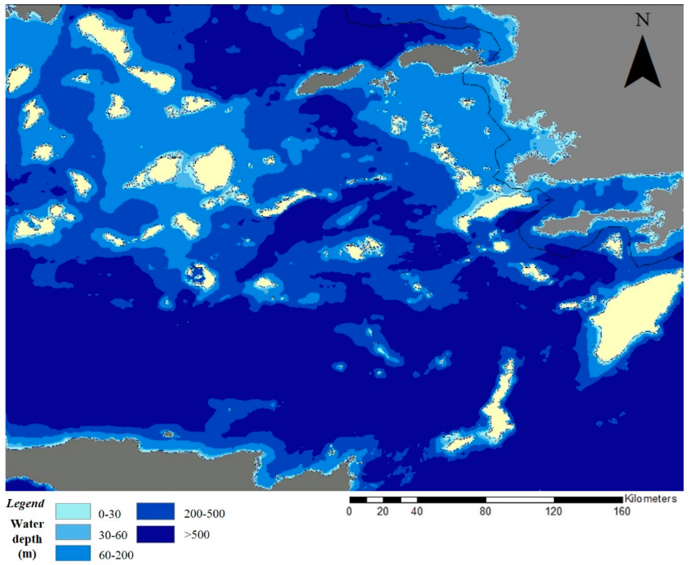
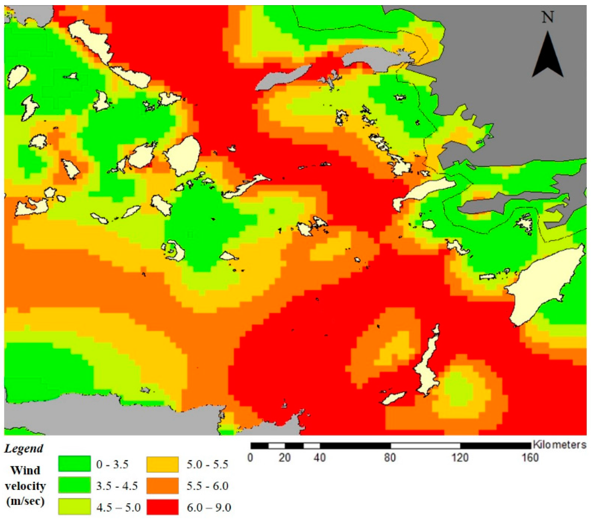
Choosing an appropriate site is, therefore, a complicated process that is based on various technical/mechanical, environmental, socio-economic parameters, as well as the relevant national legislation concerning marine spatial planning [
7]. Wind capacity is the most crucial parameter of such projects, as it provokes the development of such installments, which is attributed to its close relationship with its financial efficiency. Another crucial parameter is the seabed depth as this affects the installment and function of the project and entails the avoidance of high costs due to docking, anchorage and wiring. Moreover, other parameters are the demarcation of safety distance limits in order to preserve vulnerable areas, such as the Natura network and the migration routes of birdlife, and to distance the project from maritime links that may exist within the marine area, especially in areas with great commercial and tourist maritime presence. Finally, another parameter used, in order to evaluate the necessity of an offshore wind farm, is its distance from residential areas which is measured in parallel to define the amount of population and the energy demand of the area.
GIS has become a major tool used to select the most suitable sites for onshore and offshore wind farm installations [
8]. GIS methods for offshore wind projects have been applied in several countries around the world, such as Taiwan [
9], China [
10], Denmark [
11], Greece [
12,
13], Ohio [
14], South Korea [
15] and the Baltic States [
16]. For instance, ref. [
9] evaluate wind energy resources with the aid of a GIS according to actual local conditions. Several local restrictions, such as wind speed, water depth, land use and ecological environments, are considered in this analysis. With the aid of GIS, offshore wind potential in China is evaluated by [
10], as a combination of wind resources, technical projections of wind turbines, economic costs and spatial constraints of offshore wind farms. A model is presented by ref. [
11] called the spatially continuous resource economic assessment model for offshore wind energy (SCREAM-offshore wind) based on GIS and supply-cost curve analysis. Technical and environmental constraints through GIS are applied by [
12] to all coastal areas in Greece to identify potential areas for offshore wind farm development. GIS is used by [
13] to identify the sustainable siting of an offshore wind farm based on legal limitations, with respect to ecological and economic resources, using the island of Crete as an example. The design and implementation of a web-based Participatory Geographic Information System (PGIS) framework is presented by [
14] to evaluate the importance of three decision alternatives using different evaluation criteria for offshore wind farm suitability within Lake Erie, Ohio. Classified data and GIS are used by [
15] to apply four different marine spatial planning scenarios to Jeju Island, where offshore wind power plans have been designed and are being implemented. A preselection phase is introduced by [
16] which is based on a predefined set of GIS layers to identify a limited set of candidate sites for offshore wind farm development in the Baltic States.
Moreover, multi-criteria decision analysis plays a crucial role in offshore wind-farm siting. Several researchers have applied multi-criteria techniques to rank offshore wind-farm siting alternatives. An analytical hierarchy process (AHP) is applied by [
12] which divides the decision-making process into three parts in hierarchical terms, namely the goal (effective offshore wind farm selection in Greece), the evaluation criteria, and the alternatives (all areas not excluded in the exclusion phase). Multi-attribute decision analysis (MADA) is applied by [
14] to rank three spatial alternatives associated with different site locations within Lake Erie (Ohio) in relation to eight different evaluation criteria. An evaluation system of 74 offshore sites along the Spanish coast, as regards their potential for RES development, is used by [
6] along with multiple criteria decision analysis through the GIS system.
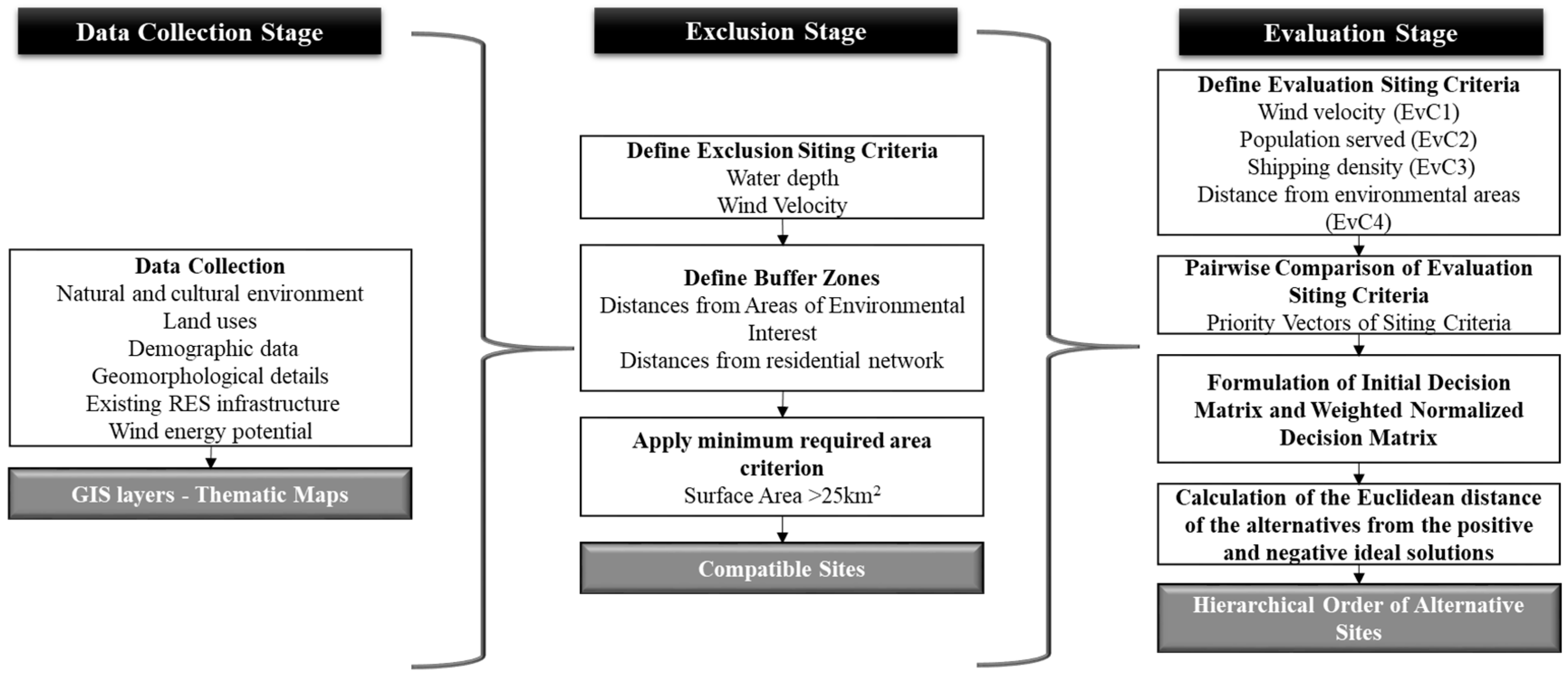
In the present paper, a methodological framework for identifying the most appropriate marine areas in the South Aegean, Greece, to deploy offshore wind farms is developed and presented. The methodology followed includes three phases: data collection, exclusion and evaluation. Three tools, namely GIS, AHP and TOPSIS are integrated in order to propose a methodological framework for offshore wind-farm site selection. GIS serves as a data-generation tool for different thematic layers and, in addition, contributes to the evaluation phase. Initially, marine areas unsuitable for the siting of offshore wind farms are identified considering a set of environmental, economic, technical and social constraints. This process includes the creation of various thematic maps and their overlapping results in eligible marine areas that are further evaluated and prioritized using TOPSIS based on a set of evaluation criteria related to financial, environmental and operational parameters. The evaluation criteria are previously evaluated through pairwise comparisons used in the AHP method. The final result of the whole methodology is the determination of the most appropriate and efficient sites for offshore wind-farm siting in the South Aegean marine environment. It should be noted that it is the first time that an integration of AHP and TOPSIS (multicriteria decision making methods (MCDM)) is performed to address renewable-energy (RE) siting issues.
In addition, the present paper contributes to the field of renewable-energy resources in the spatial level of application. The most relevant studies for offshore wind farms have been applied either for whole countries (e.g., [
11,
12,
17]) or for islands (e.g., [
13,
15,
18]). By contrast, the whole application of the present study is performed in the South Aegean region, Greece, that is divided into 13 regional units and formed around major islands. The spatial level of application is an extremely important issue. The present study focuses on a regional application that presents significant advantages in terms of energy self-efficiency. It should be noted that 100% RE supply within the electricity sector is usually only feasible on the regional level [
19] and that islands present sustainable-energy growth challenges for numerous reasons such as remoteness, limited energy resources, vulnerability to external events and strong dependence on international trade agreements [
20]. However, islands are often not or only partially connected to continental electrical networks and have to manage their energy supplies in reaching the production/demand balance while ensuring the quality of the electricity delivered [
21]. In addition, islands should address the demand peaks as energy demand is formulated mainly by tourists during summertime.
The rest of this paper is organized as follows:
Section 2 describes the methodological framework developed, as well as the exclusion and evaluation criteria used in the analysis; in
Section 3, the results of the applied methodology are presented and discussed through the formulation of various thematic maps and discussed; and
Section 4 provides the main conclusions of the present study.
4. Conclusions
The methodology used in the present paper is an integrated proposal for the siting of an offshore wind farm, whose planning stages and criteria can be adopted and used in various applications and scales of planning. The proposed methodology is applied on a regional level in the South Aegean, in order to pinpoint suitable areas for the development of marine wind farms. The main reason that this study area is selected is the high wind-energy potential of the region, which is caused by the creation of extensive high-pressure systems in the Balkans, to the north of Greece, in combination with the extensive low-pressure system of Asia Minor and the eastern Mediterranean. The paper is based on the use of geographic information systems (GIS) through the ArcMap (GIS) programme in order to create spatial databases and exclude incompatible areas. Furthermore, a combination of AHP and TOPSIS is used as a multi-criteria analysis method in order to evaluate and hierarchically rank the suitability of the areas.
On a broader framework, as regards the present paper, it is found that the siting of RES projects is a complex and multi-dimensional issue that includes various technological, special, socio-economic and environmental parameters. As has been mentioned, Greece, as a member-state of the European Union, must significantly increase its rate of RES installations, so that RES account for 20% of its total energy consumption by 2020. Consequently, a national strategy has been developed for the gradual development of RES in order to increase their share in the energy consumption map of the country; thus, the need for successful and effective siting of RES is a fundamental issue. On the other hand, the installation of new RES will make a decisive contribution to the country’s sustainable development through the production of energy from these sources.
To be specific, wind power is developing at a very rapid pace on a global level, involving both onshore and offshore installations. Marine sites have proven to be more efficient, primarily due to the stronger wind velocity which develops at sea. By combining a review of the relevant literature and the Greek institutional framework, the exclusion and evaluation criteria are selected for use. The basic parameters reviewed in order to select the criteria, along with the reduction or avoidance of any likely impact caused by the siting of a marine wind farm, are also the geographical profile (island structure) and scale of the study area. The applied methodology is divided into three stages. The first stage includes data collection, spatial depiction and development of thematic layers. In the second stage, exclusion of the incompatible areas for siting is carried out, where the criteria of installation potential, social benefit and environmental protection are taken into consideration. In the evaluation stage, the criteria used cover aspects of economic efficiency, operational integrity and environmental sensitivity.
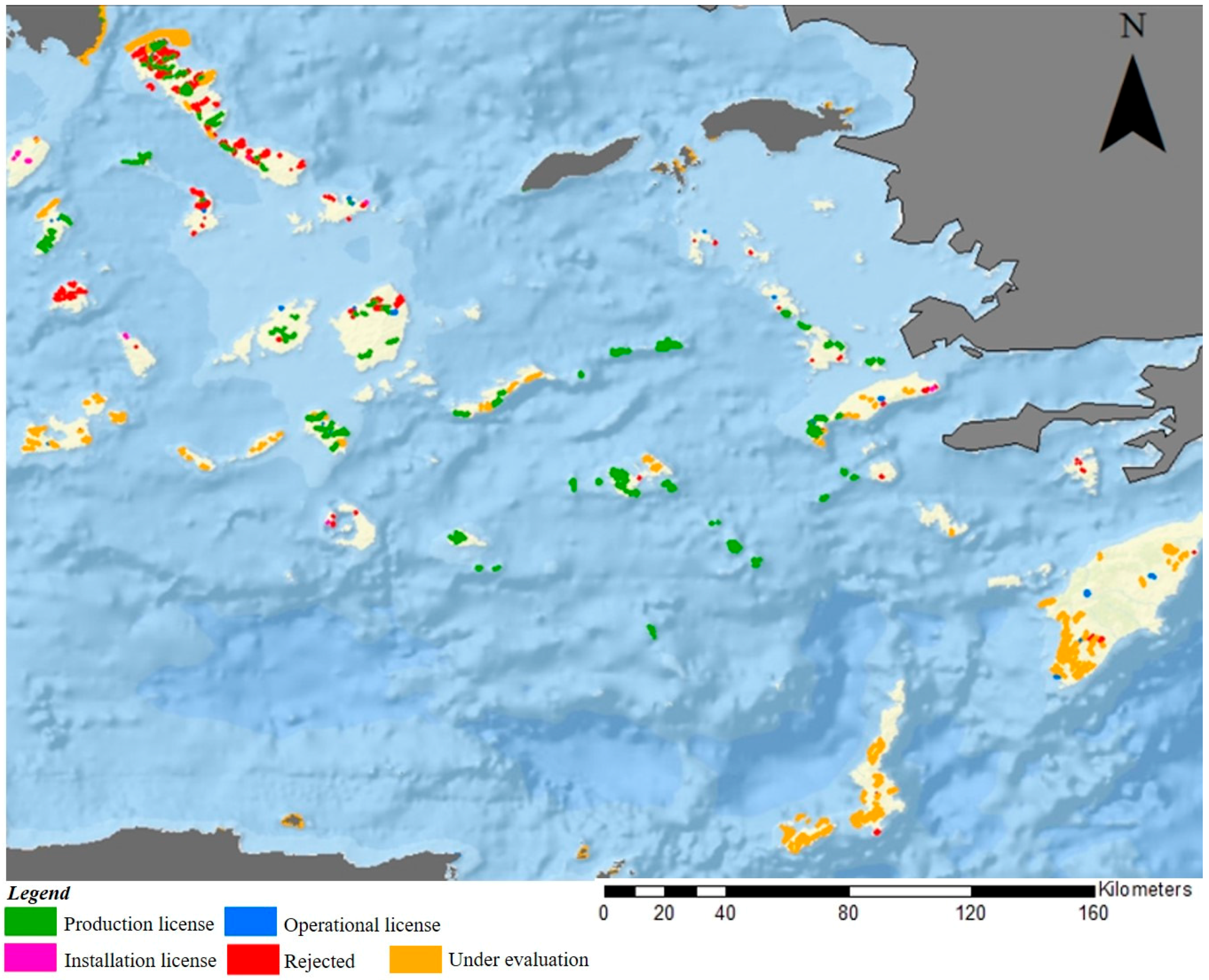
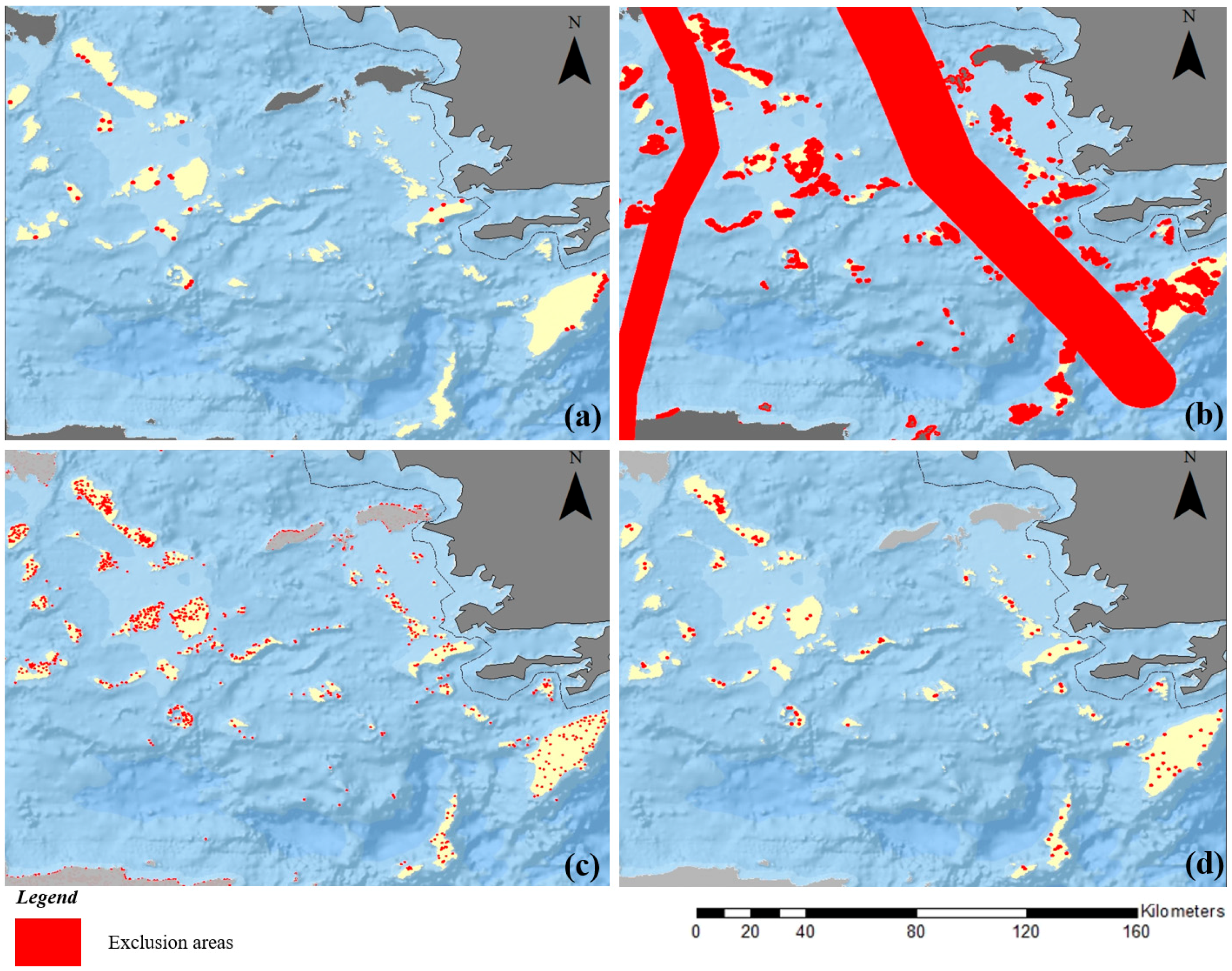
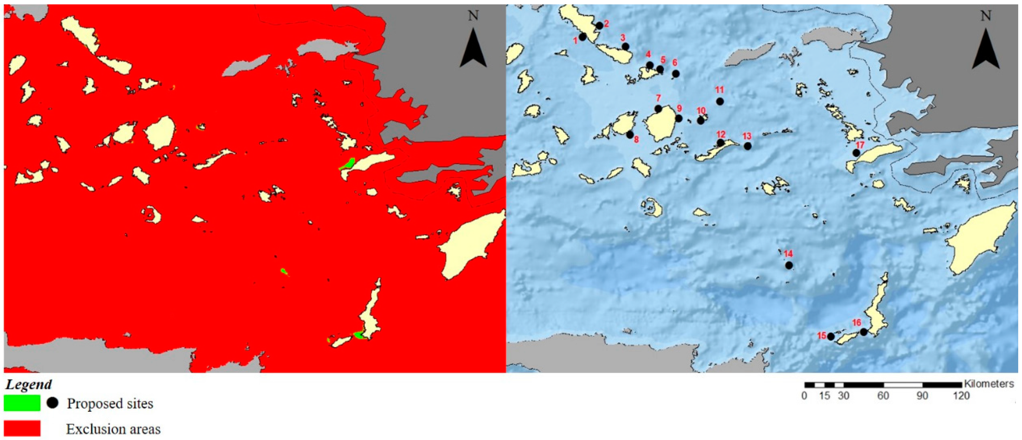
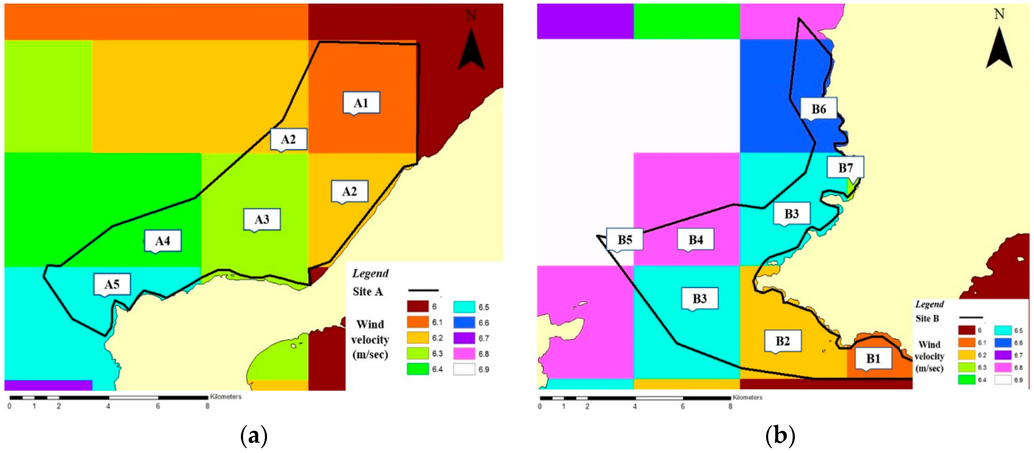
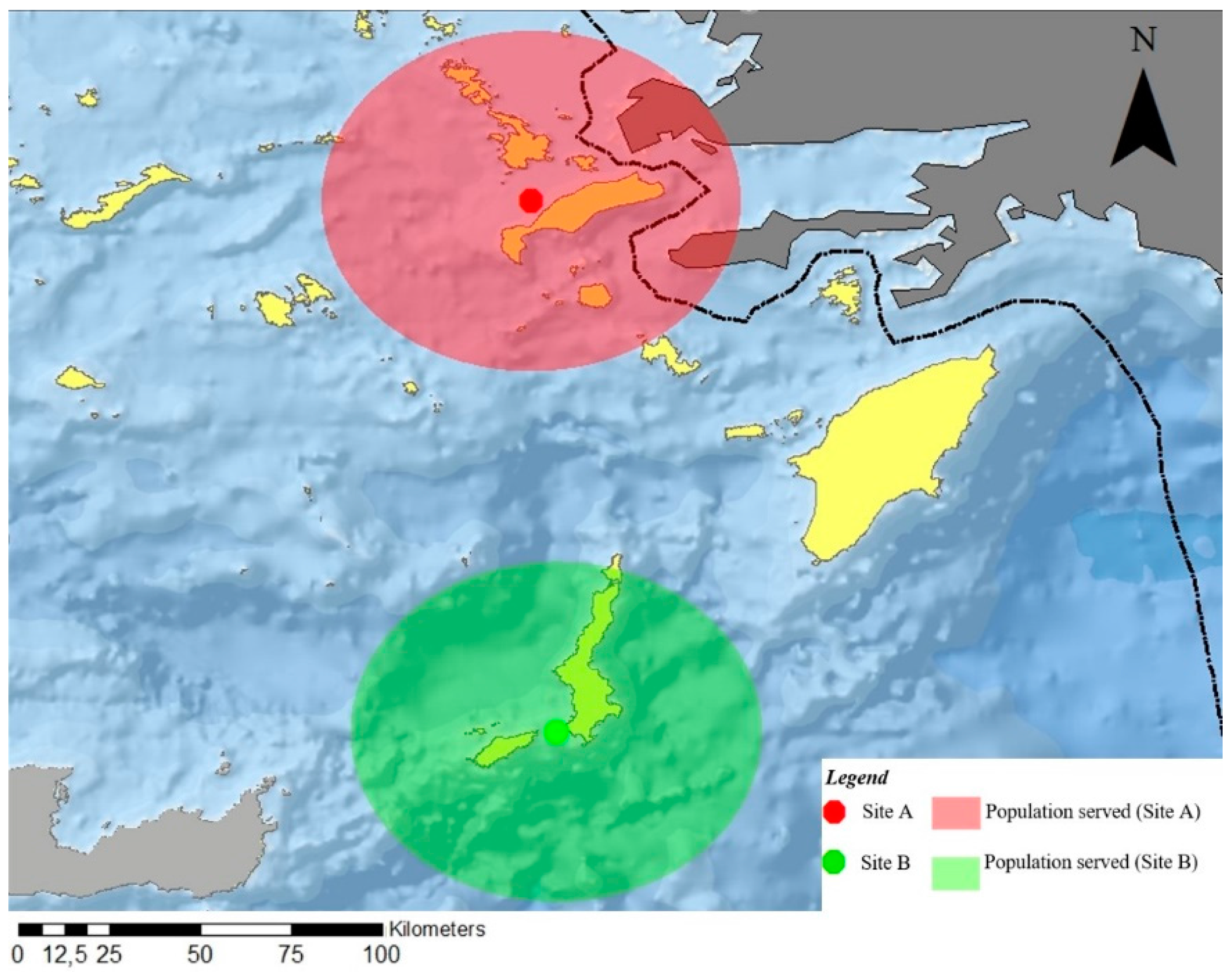
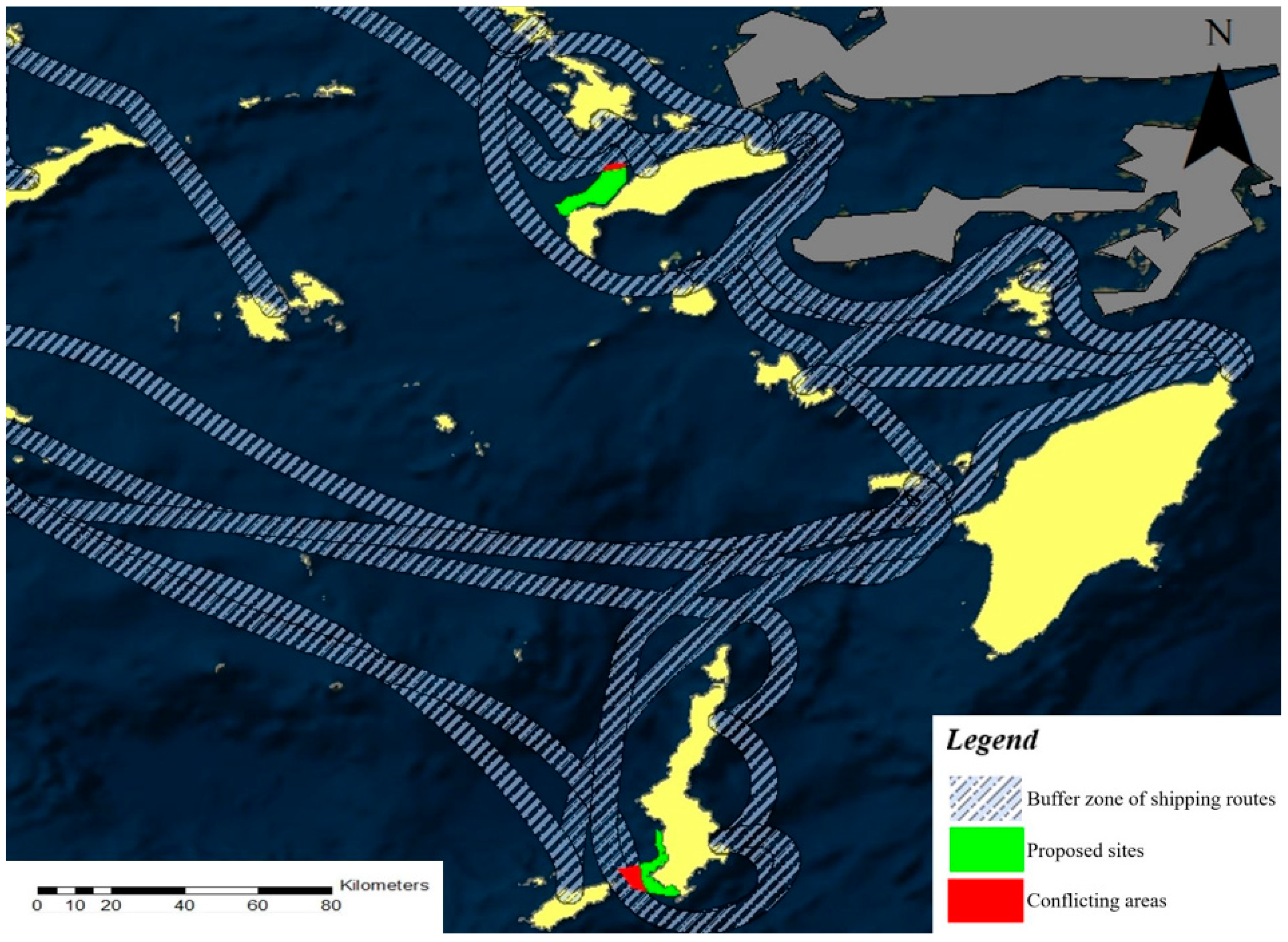
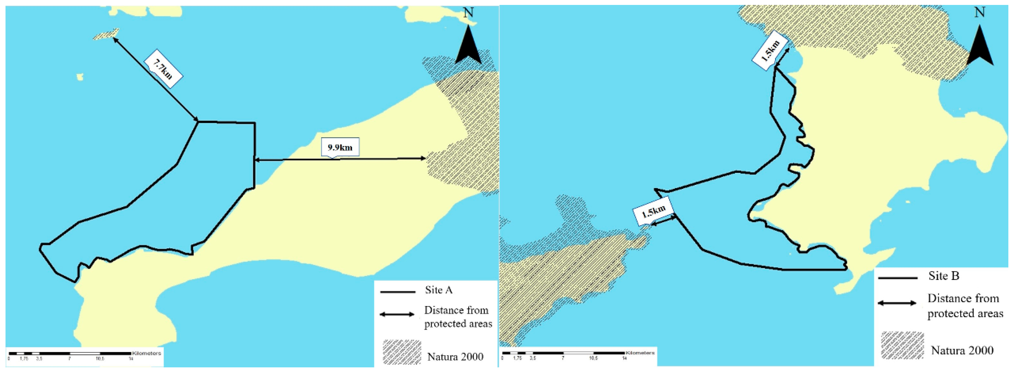
After the completion of the exclusion stage, 15 areas are initially identified as suitable for the siting of offshore wind farms. These areas are reduced further after the exclusion of areas of a small and inadequate size for an offshore wind farm, since such a project is economically unviable. For this reason, and although only two sites are finally put forward due to the strictness of the criteria, they are eligible for the extensive siting of wind farms, in order to fulfil the national goal of increasing the RES share, and the regional goal of covering the energy requirements of as many residents as possible. In the evaluation stage, the eligible areas are placed in hierarchical order with the use of the combined analytic hierarchy and TOPSIS process. The results of the application of this methodology are of particular interest, since the two proposed areas are located at a minimum distance from existing onshore wind farms or wind farms which are currently at the licensing stage.
Numerous extensions of the present paper could be performed including stakeholder involvement and public participation in the evaluation stage. In addition, the proposed methodology could be applied at any spatial scale from local to national, enhancing the decision-making process of spatial multi-criteria problems and contributing to the sustainable exploitation of wind-energy resources.


