1. Introduction
According to 2003 data, 2385 million people lived within the world’s coastal limit, which represents 41% of the global population. Twenty-one of the world’s 33 megacities are found on the coast. More than 50% of coastal countries have from 80% to 100% of their total population within 100 km of the coastline [
1]. Also, various studies estimated expected growth of the population living in the low-elevation coastal zones [
2,
3] under different scenarios [
4]. The calculated economic value of goods and services provided by coastal ecosystems showed that, altogether, coastal ecosystems contribute 77% of global ecosystem-service values [
5]. The ecological, economic and social importance of coasts have long been studied and highlighted, and their deterioration due to human activities is intense and increasing [
6,
7]. Given its current status and climate change predictions, coastal environments will be confronted with serious environmental issues that should be dealt with in advance, in order to achieve sustainable development of the most valued locations of the world [
1]. In particular, deltas have been identified as especially vulnerable to climate change and induced sea level rise [
8,
9] with foreseeable environmental, social and economic costs (indeed, Nicholls, et al. [
8] place the global costs of adaptation to sea level rise -varying by elevation- in the range of 26–89 billion dollars per year, by 2040). Deltaic areas are also exposed to other climate-related hazards such as floods, droughts and storm events. Furthermore, it has been estimated that more than 500 million people currently live in deltas, adding to arguments for protection [
9,
10,
11,
12].
In order to better understand the potential impacts of climate change in deltas—especially those located in developing regions—and with the aim of assessing different adaptation options (including migration), it is essential to understand the complex connections between biophysical and socio-economic dimensions. Climate change affects the environmental conditions of deltas through changes in temperature, rainfall, salinity, nutrients, land availability and so forth. These changes in turn affect the provision of environmental goods in general and the productivity of crop and fisheries in particular. Ultimately, all these changes affect the livelihoods, income and employment opportunities of people engaged in the agriculture and fishery sectors. Indeed, these aspects relate to wider objectives, such as the Sustainable Development Goals (SDGs) [
13] and in particular for poverty, health, education, and gender equality (especially when research such as that in Yadav, et al. [
14] find large knowledge gaps regarding the vulnerability of women to changing and an uncertain climate). Furthermore, the cited impacts also affect people working in other economic sectors, directly or indirectly, through supply-chains in the agriculture and fishery sectors both in the delta and in other regions.
In this context (where understanding potentially affected activities under climate change will help future work on future scenarios), this article aims to gather insights into the current biophysical and socioeconomic state of four study sites (covering three deltas), studied in the project DEltas, vulnerability and Climate Change: Migration and Adaptation (DECCMA), with a special focus on the complex links between climate-exposed activities and the rest of the economy. This choice was based on a key topic—the study of deltas in developing countries—where the aforementioned vulnerability is more evident and adaptation capability is lower. Furthermore, the three deltas were considered representative in terms of population and area potentially affected—according to Ericson et al. [
9], respectively as small, medium and large [
9]: the Volta Delta (Ghana), Mahanadi Delta (India) and Ganges-Brahmaputra-Meghna (GBM), called here Indian Bengal (IB) Delta (we will also call it IBD) for the Indian side and simply Bangladeshi Bengal (BB) Delta for the Bangladeshi side. The maps of the four areas of study are provided in the
Supplementary Material in Figures S1–S4.
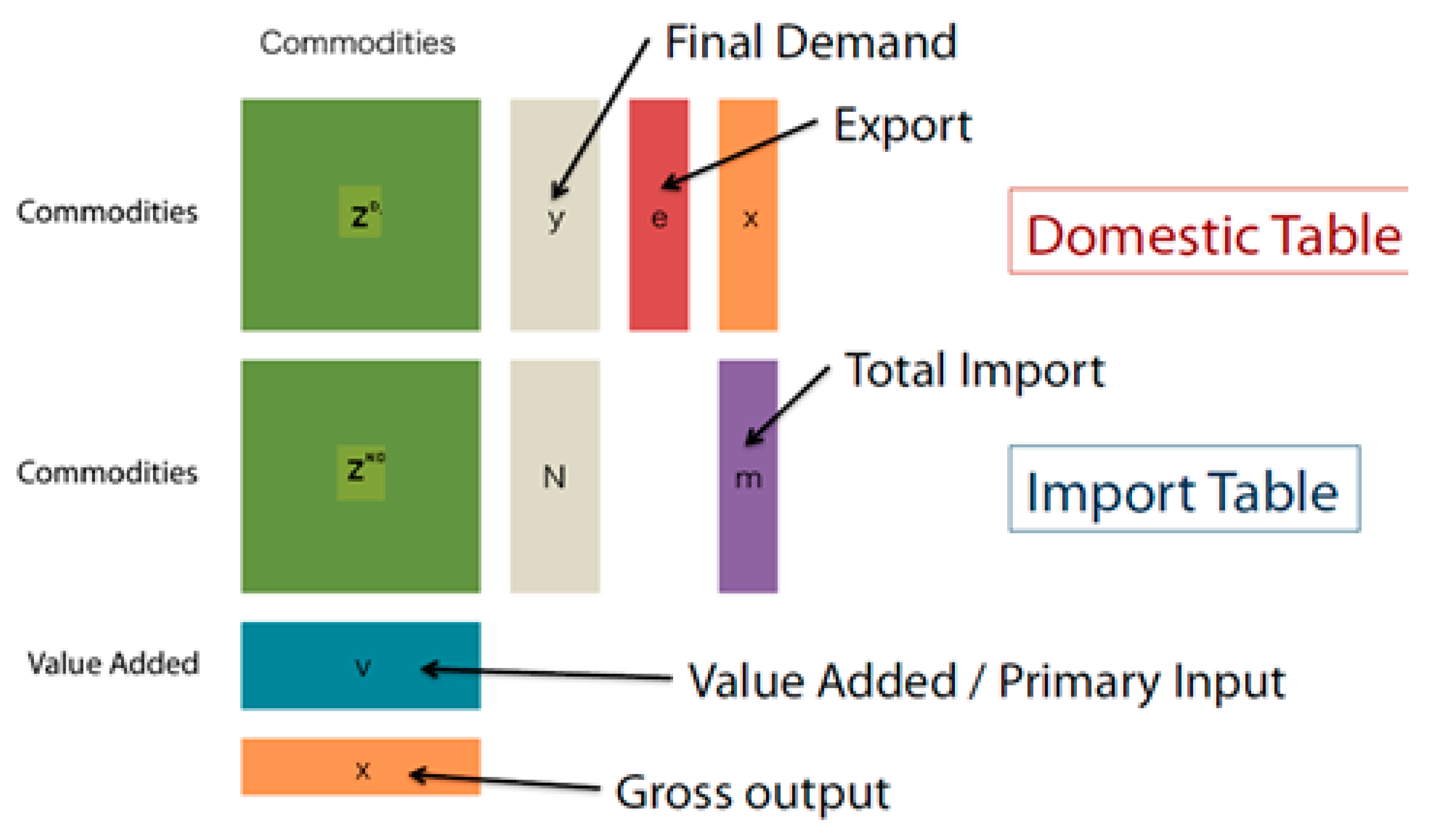
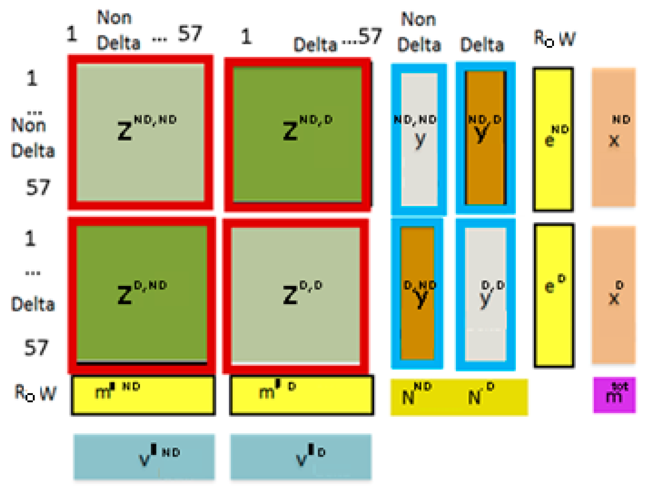
Key insights expected from the study had to do with the socioeconomic and biophysical context of the deltas, and relations and interdependencies through the supply chain of goods and services in the delta, in the rest of the country and in the Rest of the World (RoW). We studied these aspects while also comparing the similarities and differences across countries, using databases of environmentally and socially extended multiregional input-output (MRIO) tables built specifically for DECCMA. The information from the MRIO tables is used in combination with different analytical methods to better understand the biophysical and socioeconomic state of the case study areas in the context of climate change, which we first studied by way of literature review and expert knowledge. Next, we focused on the analysis of economic activities directly or indirectly exposed to climate change by making use of MRIO databases and other knowledge generated in the DECCMA project. From this information, it became particularly obvious that in all deltas the main activities affected directly by climate change are agriculture and fishing, together with a few others in specific deltas such as forestry, mining, and activities related to tourism. Since the MRIO databases provide all the direct and indirect links of activities, we examined how, downstream in the supply chains, activities such as the food industry, retail trade, textiles, and so forth, are also indirectly affected by climate change.
Furthermore, the DECCMA project has a clear gender focus, given that the potential vulnerability of women is high, markedly so in several areas of South Asia where the seasonal rural-urban migration (especially of men) takes place across these coastal areas (see more on this in Prati, et al. [
15]). Accordingly, our analysis also pays attention to gender issues, particularly in relation to employment.
The information obtained from this analysis will be used in DECCMA as background for the study of the effects of climate change in relation to migration and adaptation needs, which is the aim of project. In particular, the understanding of the current socioeconomic structures analyzed here, as well as the associated embodied socioeconomic and environmental flows, are going to be used throughout the project to understand how different natural resources and economic activities are likely to be affected by climate change, and which will be directly and indirectly impacted under different scenarios.
In
Section 1.1, we introduce the case study areas. In
Section 2, we present the methodology and data for the construction of the MRIO tables and we also present a framework for exploring the biophysical and economic structure of the deltas.
Section 3 presents the results, first, on the comparison of the economic structure of the Delta and Non-Delta part of each country (which, for simplicity, we will call “Delta” and “Non-Delta”), including an analysis of the level of climate exposure of sectors and regions from a supply-chain perspective.
Section 4 presents the conclusions and discussion.
1.1. Case Study Sites
In the following subsections, we present the study sites in terms of geography, demographics, while their climatic conditions are provided in the
Supplementary Material (1.1). The delta definitions are given by the administrative boundaries, which fall either entirely or partially within the 5 m contour line of the river deltas.
1.1.1. The Volta Delta
The Volta Delta region constituting the DECCMA study area covers a total of 3301 km
2 with an estimated total population of 863,810 in 2010. The area falls within the geological setting referred to as the Keta basin. The basin is filled with 870 meters of Paleozoic marine and non-marine sediment. This soft geology is generally comprised of quaternary rocks and unconsolidated sediments made up of clay, loose sand and gravel deposits [
1]. The Volta River system—the main source of sediment supply to this basin—consists of a larger drainage basin, a broad delta plain, a narrow shelf, a steep upper slope, and a large basin floor. The Volta Delta lies primarily in the coastal savannah zone. The vegetation is primarily swampy, interspersed with short grassland and clumps of bush and trees, mangrove areas and the Savannah woodland.
Figure S1 shows the physical map of the Volta delta region and the land cover can be seen in
Figure S5 in the Supplementary Material.
The population distributions of districts in the Volta Delta area are shown in
Table 1. It must be emphasized that the boundaries of some of the districts (e.g., North Tongu, Ketu) extend beyond the delta area.
1.1.2. The Mahanadi Delta
The Mahanadi Delta is drained by the network of three major rivers: Mahanadi, Brahmhani and Baitarini into the Bay of Bengal. The coastline of the delta is about 200 km long, which stretches from the south near Chilika to the north, up to the Dharma River. The delta covers an area of nearly 95,000 km2 and the upper part of the delta is highly populated. Sediment carrying rivers generally form deltas near the mouth where geologic, tectonic, geographic, climatic and environmental settings are suitable for formation. The Mahanadi River is one of them. The river starts building up its delta plain from Naraj where the undivided Mahanadi branches from its distributary system in the delta plain area. Mahanadi Delta is one of the largest deltas on the east coast of India.
The basin has an extensive area under agricultural use and the upper part of the delta is highly populated compared to the lower part of the delta. The Mahanadi Delta has subsurface features of depression and ridges, mostly covered with forest and low-lying areas under cultivation and human settlement. The land use practice in this delta changes over time depending on the sedimentation and morphology dynamics. Devastating floods in the delta continuously bring about changes in land use patterns. Chilika Lake, the largest coastal lagoon in Asia is situated in the far south of the delta (
Figure S6 shows the land-cover of the Mahanadi Delta).
The DECCMA delta definition comprises five districts (Puri, Kendrapara, Bhadrak, Jagatsingpur, Khurda) of Odisha. As for the 2011 census, as shown in
Table 2 the total population is around 8.03 million. In terms of literacy in the coastal districts, 76% of the population are literate, of which 54% are male and 46% are female, with Khordha having the highest male and female literacy rates. Women in the Mahanadi Delta region commonly experience many disadvantages. Most of their work is unpaid (which does not appear in employment statistics), having to work hard at home and often in the fields, while having less autonomy than their male counterparts over income and assets. Being poorly represented in policy and decision-making, their opportunities for human development are low. Women also suffer when men migrate (men comprising about 99% of the migrants from coastal areas) [
17], left to run the households with increasing work burdens and decreased roles in the community (see more in Prati, et al. [
15]).
1.1.3. The Indian Bengal Delta
The Ganges-Brahmaputra-Meghna (GBM) basin spans across Bangladesh, Bhutan, Nepal, China and India, and represents one of the largest estuarine regions of the world, the Sundarbans Delta. The IB Delta, situated in West Bengal, is comprised of two districts, North 24 Parganas and South 24 Parganas. The delta defined in DECCMA (by the pink border on the left of
Figure S3) spreads across an area of 14,054 km
2. The Government of India has declared 9630 km
2 of area in the Sundarbans as the Sundarban Biosphere Reserve. The total forest area is 4264 km
2 of which 1810 km
2 is comprised of wetlands [
18].
Figure S3 shows the map of the IB region, and
Figure S7 shows the different land use patterns. Around 44% of the total land use pattern is under agriculture (cultivable land).
According to the 2011 Census, as shown in
Table 3 the total population of North 24 Parganas is 10,009,781. The decadal growth rates of North 24 Parganas and South 24 Parganas are 12.04% and 18.17%, respectively. The growth rate of South 24 Parganas is much higher than the growth rate of 13.84% of West Bengal (the state they belong to) during the period of 2001 and 2011. As noted earlier, sex ratios in both the districts are almost identical (955 females per 1000 males) and are higher than the state-level figures of 950 females per 1000 males in West Bengal. As in the case of the Mahanadi Delta, women in the IB region commonly experience many disadvantages of the same kind, perhaps with different characteristics in terms of how migration takes place (higher proportion to a nearby mega city, as it is close to Kolkata, rather than to other states, and so forth).
1.1.4. The Bangladeshi Bengal Delta
According to the Statistical Year Book, the area of the GBM Delta on the Bangladesh side represents almost a third of the country (43,863 km
2) of Bangladesh, covering 100,807 km
2 of the Non-Delta (the rest of the country) (Statistical Year Book, [
1]). Given the selection applied in DECCMA of administrative regions (region delimited in red in
Figure S4, where in the top right corner it is represented in orange with respect to the whole country) that partially or entirely fall within the 5-meter contour, the delta definition of the BB represents 47,802 km
2.
Figure S8 shows the agro-ecological zones of Bangladesh (includes the BB Delta definition).
Looking at the demography, some 156 million people live in the delta, despite risks from floods caused by monsoons, heavy runoff, and tropical cyclones. Most of the BB Delta has a population density of some 1226 inhabitants per km
2 making it one of the most densely populated regions on earth. The annual growth rate is 1.292% [
1]. The population density is 793 per km
2 for the delta region, compared to 1041 per km
2 for the rest of the country.
Table 4 shows this and summarizes the demographic profile of the Delta and Non-Delta areas. Women in the BB Delta region also tend to experience many barriers and disadvantages, including access to health services, economic opportunity, political participation, control of finances, or to safe evacuation in case of disasters. In this last aspect, women and girls’ acute vulnerability in disasters is due to a host of gendered factors, including cultural or religious restrictions on female mobility, as well as differences in the socialization of girls which means they may not be equipped with the same survival skills as their brothers. Previous cases revealed how many women in Bangladesh did not leave their houses during floods because it was regarded as culturally inappropriate, or did not have sufficient swimming skills [
20,
21]. Also, it is not only in crisis situations where women and girls are disproportionately vulnerable to the consequences of a changing climate. Because they are (although this is not always well reflected in the documented employment statistics as we will see) the main actors in the home and in household food production (subsistence agriculture, household nutrition, water and fuel collection), they tend to be more directly reliant on natural resources and are particularly vulnerable as resources become scarce.
4. Conclusions and Discussion
Deltas have been identified as particularly vulnerable to climate change [
8,
9] with foreseeable environmental, social and economic costs. Phenomena such as sea level rise, increase in salinity, changes in hydrology, alteration of habitats or extreme events will directly affect, to a greater or lesser extent, specific activities in the Delta, such as agriculture (e.g., loss of land and reduction of productivity), fishing (e.g., reduction of stocks) or transportation (e.g., damages in infrastructures). However, it is not so obvious to what extent these impacts will spill-over to other sectors and regions through supply chains affecting employment and the income of men and women.
Some previous work, for example, the Special Feature of [
58], have addressed the sustainability of some Deltas, their livelihoods, ecosystem services, policy implications, and so forth. Along this line of research, this article has revealed some insights into the economic structure of the Volta (Ghana), Mahanadi (India) and Ganges-Brahmaputra-Meghna (GBM), (India and Bangladesh) Deltas in the context of climate change. These are the Deltas studied in the project Deltas, Vulnerability and Climate Change: Migration and Adaptation (DECCMA), with a focus placed on analyzing current socioeconomic and biophysical contexts and existing linkages between the case study areas and other regions.
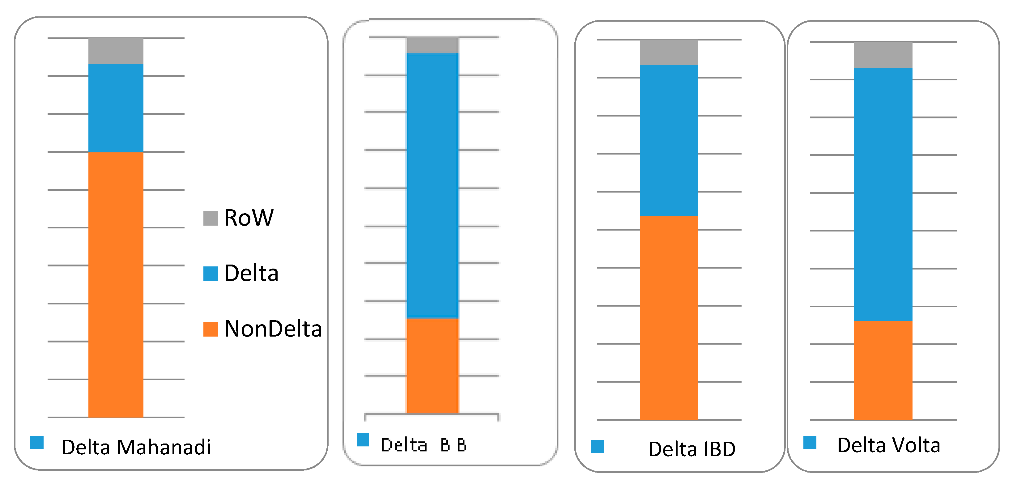
Following wide objectives within the project (such as understanding structural and socioeconomic changes), in order to better understand the potential impacts of climate change in Deltas, especially in those located in developing regions, in coastal areas, and so forth, and to assess different adaptations options (including migration), it becomes necessary to understand the complex connections between their biophysics and socio-economics. Climate change affects the environmental conditions in the Deltas through changes in climatic variables, but also of the soil, productivity, and so forth, which in turn will affect the provision of environmental goods in general, and in agriculture and fisheries in particular. Ultimately, all these changes will affect the livelihoods, income and employment opportunities of people engaged in these activities, and also people working in other economic sectors directly or indirectly linked through supply-chains. The main aims of this paper focus on these last socioeconomic aspects, with the goal of characterizing and understanding the socioeconomic relationships of the activities (highlighting e.g., dependencies, but also groups of populations more or less affected, given skill qualification and/or gender distribution, and so forth) within the deltaic areas and also within the rest of their respective countries and within the rest of the world. In order to do so, and given the challenges of developing such comprehensive databases in these contexts, there has also been an important attempt to provide the community methods and experience in studying these types of area. In particular, with a notable effort in terms of methodological and data gathering contributions, for Deltas in developing countries which have been considered representative of small (Volta), medium (Mahanadi) and large (GBM) size (especially measured in terms of population potentially affected by impacts of climate change).
In this sense, regarding the methodology and data, we have developed MRIO tables for the 4 (the GBM is split between the Indian Bengal and Bangladeshi Bengal sides) study sites. The MRIO framework reveals itself as a powerful tool to assess the economy-wide potential impacts of climate change, by providing information on the interdependencies between economic activities directly exposed to climate change (e.g., agriculture) and other activities that might be potentially affected through the supply chains (e.g., food processing) both in the hotspot (Delta) and in other regions (Non-Delta). The method has been demonstrated to be useful for analyzing three climate hotspots of different sizes in terms of populations and areas potentially affected. In this sense, this model could also be useful to assess other climate hotspots such as arid and semi-arid regions or glacier and snowpack dependent river basins.
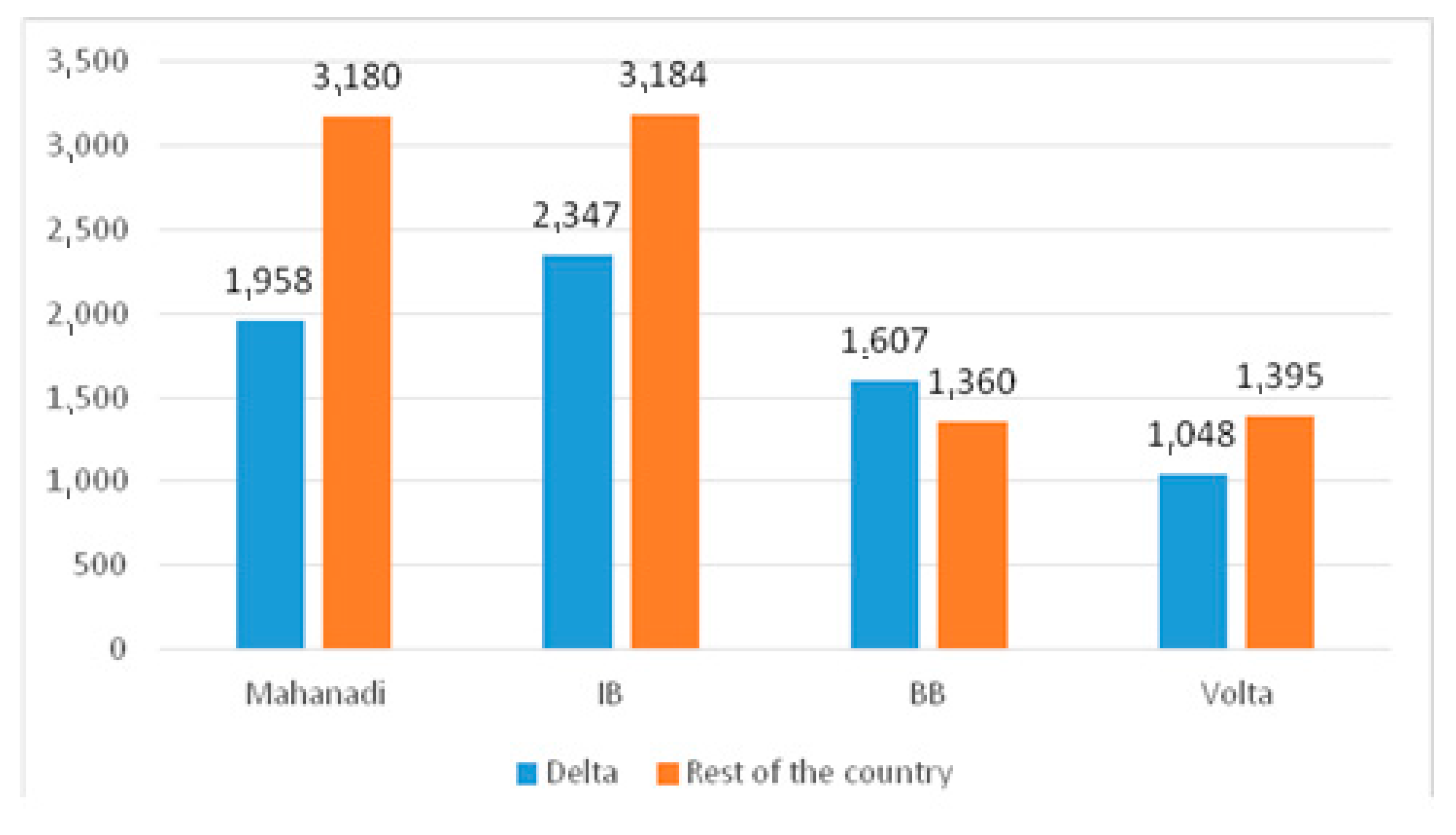
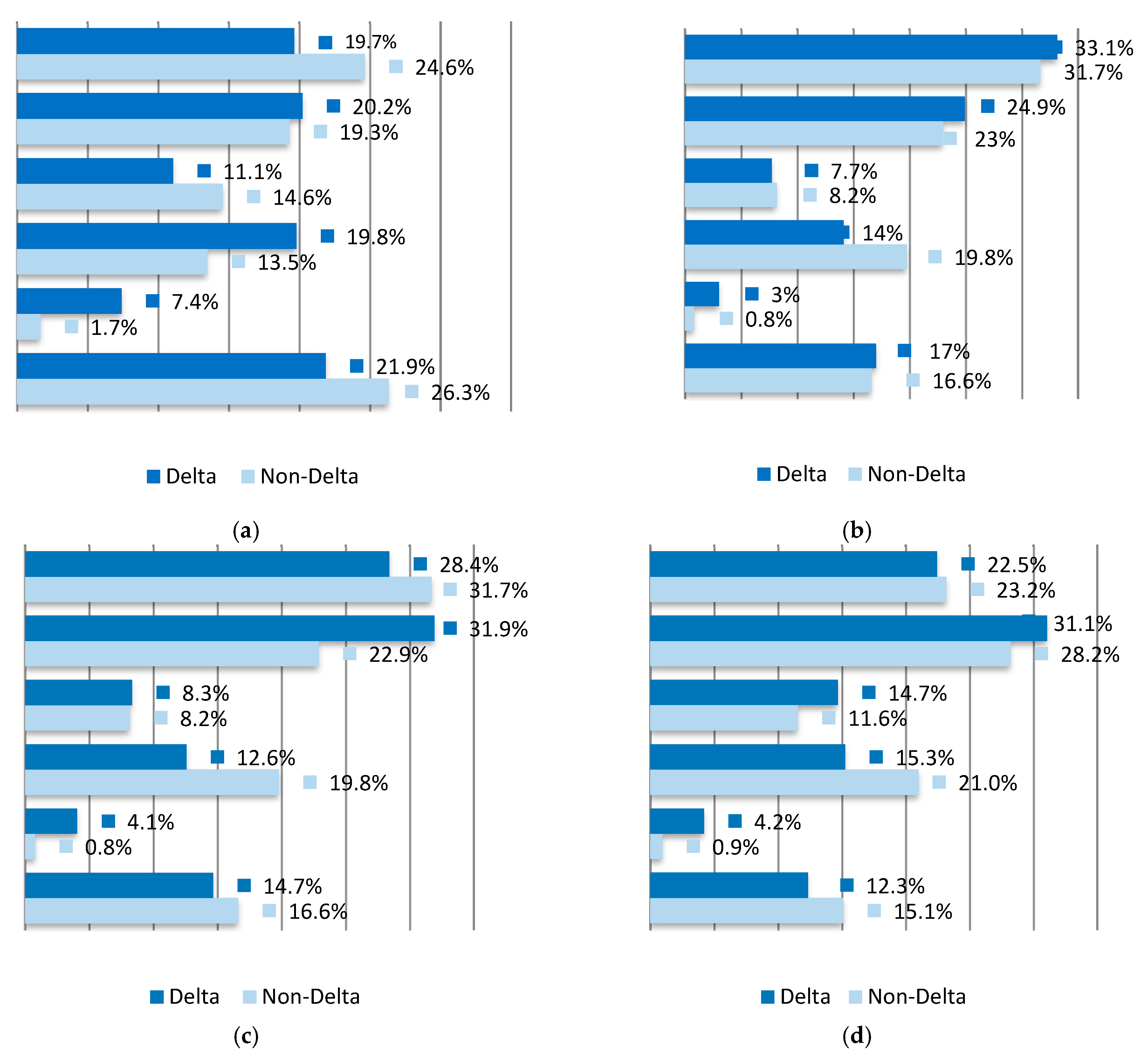
With respect to the results, from the analysis it could be concluded that even though the agricultural and fishing sectors represent a significant part of the Deltas’ economies (16–29%), other activities such as services, trade and transportation account for 50% of the GDP in these regions, as the fishing sector is much larger within the rest of the country. Interestingly some manufacturing activities were revealed to be relatively predominant in the Volta Delta economy compared to the situation in the rest of the country (Non-Delta). Key results in the Mahanadi Delta show the strong importance of agriculture (17% of the value-added) and fishing (3% of the value-added vs. 0.8%) sectors. On the contrary, the relative size in value-added of industrial activity is much smaller in the Delta than in the rest of the country (Non-Delta). For the IB Delta we found the strong importance of the agriculture sector, notably the fishing sector, which is relatively much bigger than in the rest of the country (4.1% vs. 0.8%). As a common result across all the Deltas, the trade and transport activities—which quite often go unnoticed when highlighting important sectors of the Deltas, such as small business trade, and so forth, were revealed to be more important in the Delta than in the rest of the country (Non-Delta).
In the Volta Delta, the work of females satisfies less of the final demand abroad (both in the Non-Delta and in the Rest of the World) compared to the work of males. As with the IB Delta, women in this Delta are not engaged in activities which generate either outputs or intermediate inputs that can significantly cater to external demand. In both Deltas, the embodied work of women in the Delta is most present in services, manufacturing and fishing, and in the case of the Volta Delta also in the construction sector, where women in large numbers act as helping hands in carrying labor intensive raw materials like cements, bricks and so forth, while being relatively less important in agriculture and energy. In the Mahanadi Delta, the work of females satisfies the final demand abroad more than the work of males, and this is most present in services, manufacturing and fishing sectors, while they are relatively less important in agriculture, energy or construction sectors.
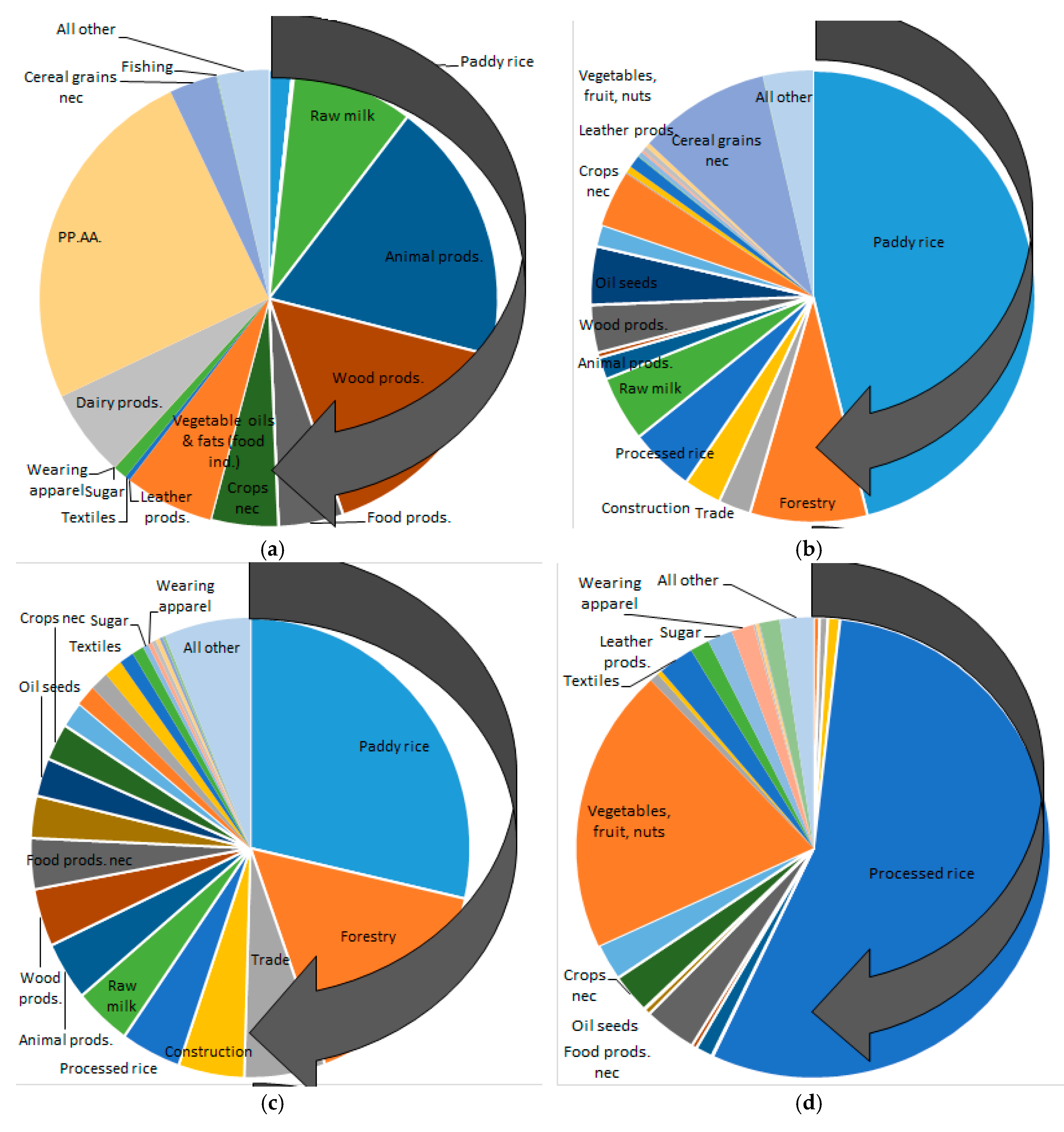
The results on land use show that in the Volta Delta agricultural land use is dominated by pastureland, but also animal products NEC and other activities downstream in the supply chains. Land use is also high for other crops and vegetables, fruits and nuts; finding more embodied agricultural land in the final demand for goods and services in the animal products NEC. The embodied land use is also relevant in sectors without a particularly important direct use, such as the food industry sectors. By contrast, in the case of the Mahanadi and the IB Deltas, agricultural land use is clearly dominated by paddy rice (560 thousand hectares and above 800 thousand hectares for the Mahanadi and IB Deltas, respectively), this changes enormously when we look at the embodied agriculture land in the final demand for goods and services. The embodied land use is particularly relevant in raw milk, and also indirectly in sectors such as the food industry and textiles.
All in all, the Volta Delta is a net importer (embodied in goods and services from other regions) of all the metrics studied including agricultural land, employment, energy and CO2 emissions. The two Indian Deltas are net exporters of embodied agricultural land (with respect to the rest of the country), embodied in goods and services sold to other regions (higher than in imports), but net importers of energy and CO2 emissions. Differences among the two Deltas include the Mahanadi Delta as a net importer of employment, while the opposite is true in the IB Delta. The results showing the relative dependence of the Volta Delta on the rest of the country and Rest of the World are surprising, and reveal vulnerabilities and lack of development in key activities. These are present in industrial activities other than some minor activities of food processing, mining, textile or other crafts, but also in agriculture. In comparison, the other Deltas show how their abundant natural endowments and conditions (fish resources, cultivable land, forests, mangroves, and so forth) should situate them more as suppliers.
All these results should be considered while taking into account the potential limitations of the present research. Despite the multidisciplinary and multi-(Delta) country teams involved in our project, there were still numerous difficulties in gathering the data for the construction of the IO tables. As also occurs in many developed countries, the comprehensive IO framework implies extensive data needs, often from different sources, which need to be made consistent (with possible biases, and under uncertainties). Of particular difficulty was finding adequate information on trade and on the transactions of intermediate goods and services across activities. Also in the regionalization process, even though the FLQ incorporates the positive aspects from previous methods, for example, it has a cross-industry foundation, and also accounts for the relative size of the region, the method obviously does not avoid the problems of estimating numerous data points. We consider however that the effort was worthwhile, since no similar framework for the studied Deltas existed (and to our knowledge, of any Delta) that could provide so much consistent information and key economic variables such as GDP, GDP per capita, employment, capital, use of resources, and so forth. Finally, with respect to the use of the information, we focused on its validation and on better understanding the (natural base and socioeconomic) contexts of the Deltas and surrounding areas, as well as their interrelations. We also identified the climate exposed-activities, but we did not model possible shocks of these under environmental change, notwithstanding, these aspects may open paths for further research.
Future research that can be derived from these constructed databases, models and analyses can be focused particularly on the effects of climate change in these vulnerable areas, and especially the expected increases in the current trends of coastal to urban migration and needs for adaptation. Migration is one of the defining features of the 21st century, with increasing relation to environmental change, and a topic that will have to be understood in order to achieve the Sustainable Development Goals (SDGs) (The links between migration and development also have implications for migration policy and practice, particularly the Global Compact for Migration (GCM), which will be agreed by the UN member states in 2018. Certain coastal areas such as the studied Bay of Bengal might be extremely affected by rising sea levels and extreme events, which might result in high levels of migration to inland regions and cross-regional migration [
59,
60]. The number of climate refugees (also often called environmental migrants, refers to those forced to leave their home region due to sudden or long-term changes to their local environment) is becoming a more important issue due to increased droughts, desertification, sea-level rise, disruption of seasonal weather patterns, monsoons, and so forth. (see e.g., [
61,
62,
63,
64,
65]). We have obtained insights for the studied areas in line with previous literature situating women as the most vulnerable to the impacts of disasters and carrying a greater burden, more prone to deepening poverty and worsening existing inequalities [
66,
67]. The (particularly male) seasonal migration from the Deltas is a wide phenomenon, and also has important gender implications and effects, as well as effects on employment (levels, wages, and so forth). For these and other factors and existing vulnerabilities for women—markedly in several areas of South Asia, see e.g. Yadav, et al. [
14] where the authors also suggest action plans and strategies to minimize vulnerability to climate change such as empowering women economically and educationally, organizing training and outreach programs, and involving them in formal climate change mitigation and adaptation policies and programs. In this line, the project has a clear gender focus, and a strong focus on migration and adaptation. The adaptation options not always result in reducing future climate vulnerabilities. For example, in Yadav, et al. [
14] there is an identification of various adaptation measures taken in Ghana, including extensification and intensification of agriculture, temporary migration, planting of drought resistant varieties, irrigation, and livelihood diversification. But many coping measures (e.g., livelihood diversifications activities such as selling of firewood and charcoal production) and adaptation responses (including intensification, extensification and irrigation) are found to currently deliver maladaptive (i.e., not adjusting adequately or appropriately to the environment or situation) outcomes. In this line, the results obtained here may be useful in policy and adaptations implementations, for example, by protecting the valuable resources and activities which provide sustainable livelihoods for the population in the Deltas, and the necessary income and resources to sell to the Rest of the World and to import other goods.

 ,
, 


