Article

Research on the Supervision and Implementation System of Territorial Space Planning from the Perspective of Resilience

1
Hunan Institute of Economic Geography, School of Economic Geography, Hunan University of Finance and Economics, Changsha 410205, China
2
Key Laboratory of Natural Resources Monitoring and Supervision in Southern Hilly Region, Ministry of Natural Resources, Changsha 410007, China
3
School of Geographic Sciences, Xinyang Normal University, Xinyang 464000, China
*
Author to whom correspondence should be addressed.
Sustainability 2023, 15(20), 14682; https://doi.org/10.3390/su152014682
Submission received: 30 July 2023 / Revised: 24 September 2023 / Accepted: 26 September 2023 / Published: 10 October 2023

Abstract

:
Enhancing the resilience of territorial space is a necessary means to cope with future risks and development uncertainties. Resilience is the goal and connotation of implementing monitoring of territorial space planning, and planning supervision is the guarantee for the formation of resilient territorial space. Although domestic and foreign planning implementation monitoring has reflected resilience thinking in the background and objectives, it has achieved good results in ecological and social resilience of territorial space, there are still shortcomings in institutional systems and methodological techniques. At present, China’s territorial space planning is still in the exploratory stage, and the supervision and implementation system has not been perfected, which has not played the expected role in enhancing the resilience of territorial space. Therefore, with a focus on the development of China’s economy and society, it is necessary to build an efficient monitoring system for the implementation of territorial space based on China’s national conditions, and improve it in terms of ideology,, theoretical, policy, regulatory, methods and techniques, in order to promote the modernization of China’s territorial space governance and the construction of an ecological civilization system, and also provide reference for the spatial planning of other countries.

1. Introduction

The word “resilience” originates from Latin and originally refers to recovery after experiencing interference. Resilience describes how a system absorbs shocks and maintains functionality during changes [1]. Since then, ecologists have applied resilience to ecological studies to describe the ability of ecosystems to recover and reorganize after external shocks, and the concept has been widely used in engineering, sociology, economics, geography, and urban and rural planning. In the field of geography and planning, “resilience” emphasizes the ability of a regional (city or region) system to withstand, adapt and recover from external disturbances (such as disasters). In the governance of risks faced by cities, the international community and policies are also paying increasing attention to urban resilience [2]. Many scholars have explored the driving mechanism of urban resilience development by constructing theoretical models. Gunderson proposed a chaotic model of adaptive cycles, describing the continuous development of the system around utilization, preservation, release, and reorganization [3]. In the construction of Urban resilience, Jabareen established the planning framework of Urban resilience and conducted practical research on the framework [4]. Erickson studied the differences in resilience building practices in different cities based on data from cities such as the United States, Latin America, and the Caribbean [5]. However, currently most research on resilience is focused on urban or smaller scales, with less attention paid to larger regional and territorial scales. A larger scale of territorial space encompasses more diverse natural systems and more complex social systems, facing more uncertainty in their evolution and development process. The concept of “resilience” emphasizes the need for flexibility in dealing with uncertainties in the natural environment and social development, providing a new perspective on governance for national space to cope with future risk disturbances [6].
The “resilience of territorial space” refers to the ability of territorial space resource allocation to provide spatial resources and pressure resistance conditions for disaster and risk prevention and disposal, thereby enabling society to quickly resume operation and sustainable development [7]. This article summarizes it as ecological resilience, social resilience, and economic resilience. China has the third largest territorial area in the world, with complex and diverse terrain, including plains, plateaus, mountains, hills, and basins; The alternation of continental monsoon climate and oceanic monsoon climate affects China’s temperature and precipitation. China has a population of over 1.4 billion, and there is also a significant difference in economic and social development between the eastern coastal areas and the central and western regions. These all require China to enhance its territorial space resilience to cope with more uncertainty and challenges, in order to achieve sustainable development. Integrating the concept of “resilience” in spatial planning is a common research hotspot both domestically and internationally. Many foreign studies have made efforts to establish a paradigm of resilience planning in planning policy formulation through a detailed analysis of the essence of “resilience”. The framework of resilient urban planning should pay more attention to the improvement of dynamic adaptability [8], in order to enhance the city’s ability to defend, absorb, respond, adapt, and recover from risk disturbances [9]. Resilience oriented spatial planning advocates multi risk management and eliminates risk threats through coordinated allocation of ecosystem elements [10]. When dealing with climate change, a reasonable spatial form can not only reduce the frequency and intensity of extreme climate disasters, but also enhance the city’s climate resilience and adapt to climate change [11]. Greening spaces can reduce surface temperature and improve spatial resilience [12]. In response to climate change, it is necessary to reasonably allocate natural and social resources, carry out overall and coordinated planning, and establish a resilient disaster prevention system with regional coordination [13].
In May 2019, the “Opinions of the Central Committee of the Communist Party of China and the State Council on Establishing a territorial space Planning System and Supervising Its Implementation” proposed that China’s territorial space planning is an arrangement made in terms of space and time for the development and protection of a certain region’s land space, including overall planning, detailed planning, and related special plans. The country, province, city, and county shall formulate overall land spatial plans, and each region shall formulate township land spatial plans based on actual conditions. Its goal is to improve the system of laws, regulations, policies, and technical standards for national spatial planning by 2025; Fully implement the mechanism for monitoring, warning, and performance evaluation of national land and space; Establish a national spatial development and protection system based on national spatial planning and using unified use control as a means. By 2035, we will comprehensively enhance the modernization level of the national spatial governance system and governance capabilities, and basically form a national spatial pattern that is intensive and efficient in production space, moderately livable in living space, beautiful in ecological space, safe, harmonious, competitive, and sustainable in development [14]. In January 2020, the “Guidelines for the Compilation of Provincial-level territorial space Plans (Trial)” listed “improving territorial space resilience” as one of its guiding requirements [15].
China’s resilient territorial space planning and construction focuses on six aspects: establishing and improving the legal and regulatory system, rationalizing the administrative management system, comprehensive disaster risk survey, the participation of the whole society, the application of information technology, and the preparation of comprehensive disaster prevention planning [16]. Integrating the concept of resilience planning into the national spatial planning system requires implementation from three levels: firstly, at the overall planning level, fully considering the requirements of resilience; Secondly, at the level of special planning, formulate comprehensive and resilient city special plans, and coordinate relevant professional special plans; Thirdly, at the level of detailed planning, implement the resilience requirements in the overall plan and the content of the resilience special plan [17]. Although domestic and foreign studies have emphasized the role of planning in enhancing the resilience of territorial space, how to effectively enhance the resilience of territorial space is still an urgent problem that needs to be solved in China’s national land spatial planning system. First and foremost, China’s urbanization process continues to accelerate, and the size of the urban population continues to grow. The territorial space planning system needs to fully consider the needs and development trends of urbanization, ensuring sustainable urban development and coordinated urban-rural development. What is more, a complete legal system to support territorial space planning has not yet been established. To effectively address these issues, a real-time and dynamic monitoring system is urgently needed. Our team envisions incorporating the concept of resilience at the macro level, using resilience strategies at the macro level, and ensuring resilience implementation at the micro level of communities [18]. Furthermore, exploration of resilience planning in management and implementation must be strengthened [17]. Enhancing territorial space resilience, both as a long-term process and a critical goal of modern governance, must be thoroughly planned and strictly monitored [19].
This article uses methods such as literature analysis, induction, and comparative analysis to review the development process of domestic and international spatial planning supervision and implementation systems and key technologies and prospects for the development trends of the territorial space planning supervision and implementation system and technological methods, in order to provide a scientific reference for the top-level system design and approach to resilience territorial space planning.

2. The Connotation of Supervision over Implementing Resilient Territorial Space

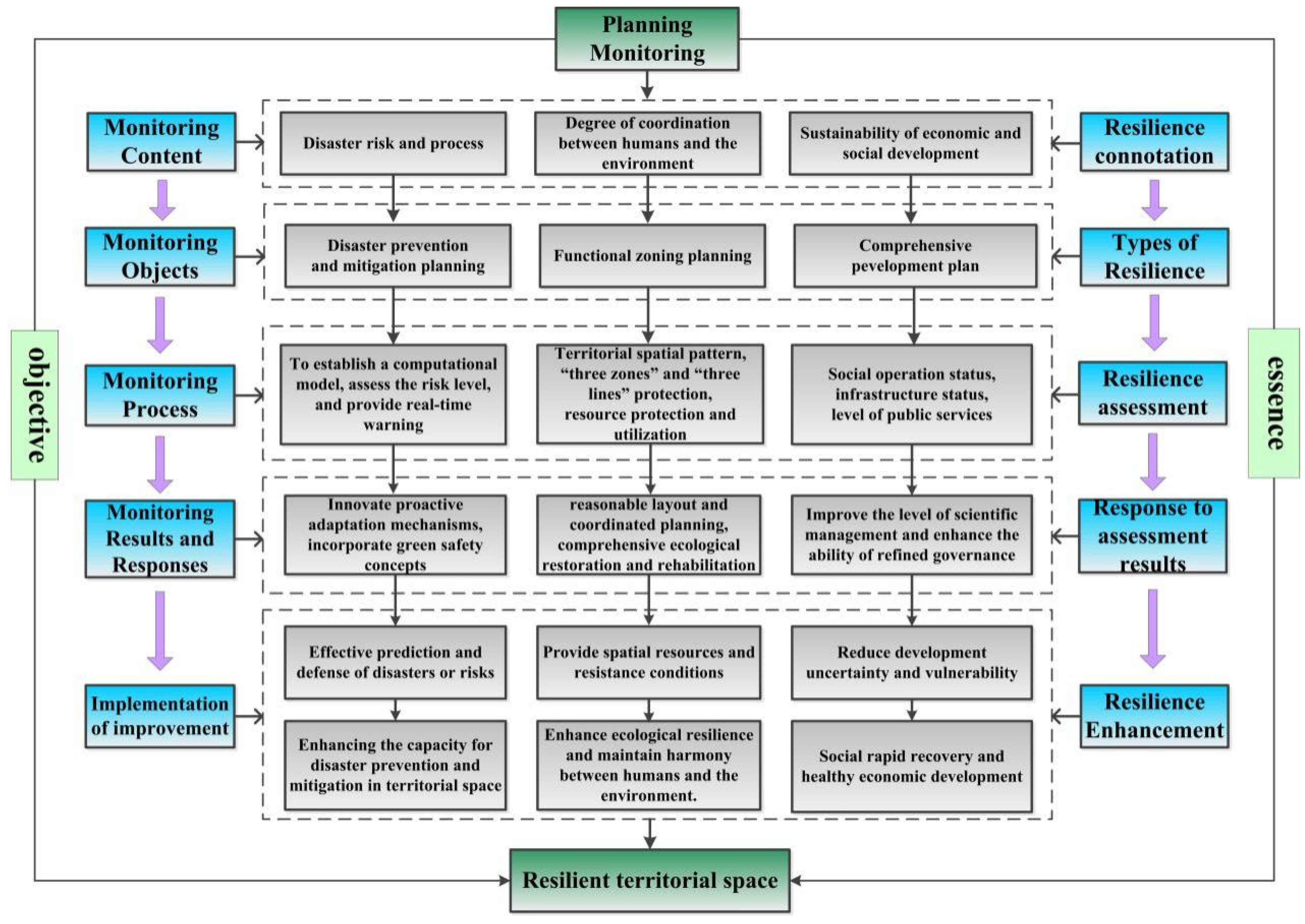
2.1. Resilience Is the Goal of Implementing Monitoring of Territorial Space Planning

Enhancing the resilience of territory is an important content and effective strategy for modernizing governance capacity [7]. In planning and monitoring, the first step is to establish quantitative calculation models for disaster risk assessment, and carry out fine-grained calculations of disaster susceptibility, danger, vulnerability and risk throughout the process. Provide real-time warnings for regions that may cause economic damage. Based on the monitoring results, make modifications and adjustments to the plan, and collaborate with the planning department, geological, meteorological, and hydrological departments to deepen the real-time monitoring, evaluation, and early warning work of geological disaster risks. Improvement requirements for spatial patterns, infrastructure, and public services in the region are put forward to provide space resources and pressure-resistant conditions for disaster disposal. Secondly, based on a comprehensive analysis model of dual evaluation (evaluation of resource and environmental carrying capacity and suitability for national spatial development) and dual evaluation (evaluation of the current status of national spatial development and protection and evaluation of the implementation of current spatial planning), the degree of harmony between human and land is judged, and its changes, coordination and adaptability with economic and social development are dynamically and timely evaluated [20]. They support urban physical examination and evaluation, as well as spatial governance for land use control. They further enhance the scientific and refined governance level of land space.

2.2. The Connotation of Resilient Territorial Space Planning

Planning monitoring includes two aspects: real-time monitoring and dynamic evaluation. Real-time monitoring is a dynamic warning during the process of land space construction. This reflects whether the construction scale exceeds the planning, and the problems encountered during the development process, transforming passive, static, exploratory results of medium- and long-term evaluations into an active, dynamic, and exploratory mechanism of annual examination [21]. Dynamic evaluation is a dynamic feedback on the implementation of land space planning at a certain stage, which is an important link to ensure the transformation of planning from static blueprint-style planning to dynamic policy-style planning. It includes evaluations of the “three zones and three lines” (The “three zones” refer to three types of territorial space: urban space, agricultural space, and ecological space. The “three lines” correspond to three control lines: urban development boundaries, permanent basic farmland, and ecological protection red lines delineated in urban space, agricultural space, and ecological space) protection [22], natural resource protection and utilization, ecological restoration, and land comprehensive management. It enhances and develops the quality of land space and consolidates the supporting guarantee system for the resilience of land space [23]. In planning monitoring, it is also possible to monitor the change and impact of residents’ diet structure, build a resource-saving diet model, monitor the industrial transformation of resource depletion cities, and study how to enhance economic resilience [24]. By doing so, reduce the uncertainty and fragility of the development process of urban and rural areas.
The improvement of national spatial resilience is reflected in three aspects: “enhancing national spatial disaster prevention and control capabilities”, “enhancing ecological resilience, maintaining human land harmony”, “rapid social recovery, and healthy economic development”. In order to achieve these goals, it is necessary to clarify the monitoring content and the connotation of resilience, and distinguish the resilience categories corresponding to different monitoring objects; Develop a scientific monitoring process and conduct resilience assessment; Timely respond to monitoring and evaluation results, and take targeted measures to improve the implementation of the plan. Therefore, the requirements for planning and monitoring should be higher, and the concept of resilience needs to be integrated throughout its entire process (Figure 1).

3. The Expression and Effectiveness of Resilience Thinking in Domestic and International Planning Monitoring

3.1. The Expression of Resilience Thinking in Planning Monitoring

The concept of resilience is reflected in the background and goals of planning monitoring: the concept of resilience in foreign planning monitoring originated in the process of reform and decentralization, in order to solve environmental and land rights issues in construction and development, and improve development efficiency; In China, it emerged in the process of land planning and development after the reform and opening up, in order to adjust policies in a timely manner according to the actual situation and achieve refined governance.

3.1.1. The Expression of Resilience Thinking in the Background of Planning Monitoring

In 1848 and 1875, the United Kingdom promulgated the Public Health Act and the Housing Improvement Act [25] respectively, which made provisions for urban sanitation and housing to solve the increasingly serious environmental problems. In Germany (Deutschland), when there was no unified regulatory and supervisory system throughout the country, the General Law for Prussia and other laws granted all landowners the right to develop and change their land to reduce the problems caused by development and construction [26]. Subsequently, the Road Red Line Law further granted local governments the power to expropriate land and issue building bans, distinguishing the content of “urban planning” and “construction management”. During the same period in Japan, with the promulgation of the City Planning Law and its supporting laws, the concept of planning zones was clarified and it was stipulated that no new buildings or changes in land use would be permitted without permission [27]. In 1916, New York was the first city in the country to issue the Zoning Ordinance, which controlled large and high-rise buildings and separated residential, commercial, and industrial areas. Subsequently, other cities in the United States followed New York’s lead and formulated their own local zoning regulations. The US Department of Commerce issued the State Planning Authorization Act Standard (1922) and the City Planning Authorization Act Standard (1928), which promoted the comprehensive development of urban planning and zoning. Since the reform and opening up, China has mainly carried out supervision of the implementation of land use master planning. Based on the control indicators of land use planning, a dynamic monitoring indicator system for planning implementation was constructed. By comprehensively and systematically monitoring and comparing with the planning goals, indicators, strategic orientation, and economic and social development situation, warnings are given on the direction, progress, and degree of planning implementation, so as to adjust the planning implementation strategy in a timely manner and correct deviations in planning implementation.

3.1.2. The Manifestation of Resilience Thinking in the Goals of Planning Monitoring

In order to resolve land use conflicts arising from World War II, coordinate urban development, and improve overall management efficiency, some countries began to shift from “blueprint planning” to “public policy”. In 1950, Japan promulgated the National Comprehensive Development Law to carry out comprehensive land development and protection, in order to achieve reasonable industrial allocation and improve social welfare. The U.S. federal government’s Intergovernmental Cooperation Act grants state and regional planning agencies the right to review and evaluate the use of federal funds, as well as the relationship between state and regional planning goals and policies, to promote sustainable development of states and regions, resulting in an increasing number of community plans and extension of the spatial planning system. In the 1980s, the theory of “interactive planning” and evaluation emerged, emphasizing the interactive relationship between planning goals and processes. Under this influence, the resilience thinking in planning monitoring goals continues to develop [28]. A large number of European countries have promoted “structural simplification” and “power localization” in the vertical direction to adjust the relationship between the central and local governments, improve the decision-making status of local governments, and cooperate horizontally with other relevant departments and organizations to track, coordinate, and provide comprehensive monitoring and evaluation results for planning.
At the same time, China has established a national spatial basic information platform for vertical transmission and horizontal coordination, which is of great significance in achieving refined and digital governance, promoting the integration of multiple regulations, and public participation. Subsequently, with the construction of urban dynamic monitoring data platforms, the improvement of monitoring and early warning feedback mechanisms, and the application of monitoring results, the monitoring system began to take shape. Although there are significant differences in the means of planning and monitoring targets both China and internationally, the core of both revolves around “structural simplification” and “power localization”. The former makes the monitoring responsibilities of each level clear, forcing each level to respond in real-time to various possible events. The latter has transformed the relationship between the central and local governments from being directive-oriented to cooperation-oriented, greatly activating the vitality of local monitoring, while supplementing “structural simplification”, truly ensuring that each level of monitoring has the right to act on the impact of planning implementation and establishing a dynamic monitoring mechanism that conforms to the characteristics of each region.

3.2. The Effectiveness of Planning Monitoring in Enhancing Resilience

With the continuous development of planning and monitoring, both domestically and internationally are gradually achieving their monitoring goals, achieving some results: in improving the ecological resilience of territorial space, reducing human interference with the natural environment, forming a monitoring system that closely combines system and technology, providing guarantees for achieving harmonious coexistence between humans and nature; In terms of enhancing the social resilience of territorial space, public policies have been optimized, conflicts of interest have been reduced, and the ability to respond to emergencies has been enhanced.

3.2.1. The Effectiveness of Planning Monitoring in Enhancing the Ecological Resilience of Spatial Space

The UK enacted the Public Health Act and the Housing Improvement Act, with the former effectively addressing some of the ecological issues brought about by the Industrial Revolution, and the latter expanding the planning authority of local governments to control entire residential areas and have the power to force local governments or construction units to develop detailed “improvement plans” that comply with ecological requirements before development [25,26]. In 1976, Germany enacted “Combined Landscape Planning”, and landscape planning monitoring began to be combined with land use, urban planning, and other special planning. In the same year, the Federal Nature Conservation Act was promulgated, which made landscape planning monitoring a tool for nature conservation, provided legal protection for its implementation, and linked landscape planning monitoring with the “Intervention Compensation Regulations”, strictly requiring each department and relevant stakeholders to fulfill their respective responsibilities and take compensation measures for human activities that interfere with nature, minimizing damage to nature. In the modern planning era, Germany’s planning for protecting spatial patterns gradually took shape [29]. In 2002, supported by GIS and remote sensing technology, Germany promulgated the National Nature Conservation Act, which, compared with the “Intervention Compensation Regulations” of 1976, not only requires compensation for soil, but also includes compensation for damage to biodiversity and species. The compensation standards are the responsibility of the corresponding planning regulators. Generally speaking, all national land consolidation projects involving changes in land use require environmental compensation. In the 1970s, Japan promulgated the “Third Comprehensive National Development Plan”, which for the first time emphasized the suitability of human habitats, proposed the concept of establishing “agricultural cities”, and fully combined national construction with ecological environment construction. Efforts were made to coordinate the relationship between humans and the natural environment, control the concentration of population and industry in large cities, promote the effective and rational allocation of resources, and build a good comprehensive living environment, ultimately achieving the goal of “people-oriented, harmonious nature”, that is, the so-called “settling concept” model [30].
In 1996, China began to use satellite remote sensing technology to conduct dynamic monitoring and research on land use, and by 2002, had completed monitoring of land use in 25 major cities. Now, the “14th Five-Year Plan” monitoring plan is being fully implemented, enhancing the construction of grassroots basic capabilities, accelerating the application of new technologies and equipment such as satellite remote sensing, unmanned aerial vehicle surveys, and ground walking monitoring, and enhancing the synergy and linkage between monitoring and ecological environmental supervision, environmental impact assessment, law enforcement, and emergency response. In terms of optimizing the institutional environment, efforts are being made to promote the promulgation of the “Regulations on Ecological Environment Monitoring”, consolidate legal and regulatory guarantees, and promote the implementation of reforms and improvements by monitoring institutions below the provincial level, further rationalizing law enforcement and monitoring mechanisms. The close combination of system and technology has formed a set of ecological protection space real-time dynamic monitoring system with modern thinking and technology covering the entire region.

3.2.2. The Effectiveness of Planning Monitoring in Enhancing the Social Resilience of Spatial Space

In the early stages of urbanization, when the level of urbanization within a country is low, most countries rely on central macro-monitoring as the main monitoring method to address urbanization issues. For example, Prussia established construction permission regulations to reduce obstacles to development and construction management. The federal government and state governments jointly issued laws, regulations, and supporting policies related to space, guiding the operation of internal planning and monitoring. At the same time, some temporary collaboration agencies composed of professionals were established in various development priority areas to deal with special problems, such as the “Ruhr Coal Industrial Zone Residents Association” established in 1920 and the “Permanent Committee on Hamburg-Prussia Land Planning” established in 1929, which were responsible for coordinating land development, joint construction of facilities, and resource sharing in the region, greatly accelerating regional coordinated development and enhancing the region’s ability to cope with uncertainties and multiple interferences [31]. As urbanization rapidly develops, the originally established macro-planning monitoring blueprint gradually becomes inadequate for social development and is unable to address complex social problems. Therefore, the central government began to pay attention to regional public policies, actively decentralizing power and improving monitoring vitality. In the United States, the goals of zoning have progressively evolved from the basic guarantee of public health, safety, and welfare to achieving urban green and sustainable development and social justice. Overall, zoning control has achieved great success at different stages, adapting to the needs of urban development at different stages, and has now developed into a comprehensive urban spatial control tool that combines seriousness and flexible dynamism.
With the development of remote sensing and GIS technology, planning and monitoring systems have become increasingly mature. In 1992, the UK established the Planning Inspectorate, which oversees local planning reviews, appeals related to land development planning permits, and applications for major national infrastructure projects. This simplified the monitoring structure, greatly improved monitoring efficiency, and enabled rapid resolution of local characteristic issues, effectively enhancing the social resilience of territory and space [32]. In subsequent development, Manchester and London’s planning supervision can be taken as examples. Manchester issued the “Manchester Development Plan 2012–2027: Core Strategy”, which lists the specific monitoring results of each target and indicator. London has released 15 “London Planning Annual Monitoring Reports” from 2005 to 2019. The monitoring report compares dynamic monitoring results with the implementation policy plan, provides timely feedback on policy performance and issues, and provides information for reviewing London’s plans or implementation policies to determine whether to optimize or revise the London plan or policy. This has formed a cycle of “decision-making–implementation–monitoring–feedback” dynamic supervision and feedback mechanism [33]. In terms of urban resilience evaluation, Ongkowijoyo proposed a resilience evaluation model based on risk criticality, which evaluates the resilience of scenario based infrastructure systems [34].
China has fully studied the monitoring processes of European countries and borrowed their monitoring experience. It has launched pilot work for the construction of the “National Urban Planning Supervision and Management Information System”, which comprehensively monitors land use, roads, green spaces, water systems, and construction projects. It issues warnings on the direction, progress, and degree of planning implementation, so as to adjust the planning implementation strategy in a timely manner, correct planning implementation deviations, and further expand the dynamic monitoring and management of urban planning implementation, achieving significant results.

3.2.3. The Effectiveness of Planning Monitoring in Enhancing the Economic Resilience of Spatial Space

Planning, monitoring, and coordinating the three major layouts of production, life, and ecology are conducive to stimulating the endogenous growth momentum of the region, promoting industrial optimization layout, and enhancing the proactive adaptability and self repair ability of the economic system [35]. Develop a diversified economy, vigorously develop an innovative economy, and create a more flexible and diversified economic structure. The facility space in urban planning should pay more attention to the economic benefits of land use and avoid redundant or excessively concentrated infrastructure construction. Planning monitoring is systematic and comprehensive in enhancing the resilience of territorial space, mainly reflected in three aspects: enhancing ecological resilience, social resilience, and economic resilience. Planning and monitoring play a catalytic role in the above three aspects, which is conducive to timely detection of ecosystem changes, reducing ecological damage, and protecting the environment; Beneficial to strengthening society’s ability to respond to public events and maintaining social stability; It is conducive to optimizing the layout of industries, providing economic benefits, and promoting healthy economic development. Ecological protection and economic and social development are dialectically unified and mutually reinforcing. As an important shelter for life on Earth, ecosystems can provide energy, food, materials and other resources for economic and social development. The stability of ecosystems is the foundation of human development; Economic and social development, as well as the improvement of people’s material living standards, can continuously build consensus and provide a technological and material foundation for ecological protection.

3.3. The Deficiencies in the Current Planning Monitoring

3.3.1. Institutional System Aspect

Most countries adopt a monitoring system based on “law + evaluation”, but in the most important evaluation stage, self-assessment by the government is mainly relied upon, with third-party evaluation as a supplement, greatly reducing the objectivity of the evaluation. In practical evaluation, third-party evaluation is often the planner and implementer of the plan, making it difficult to ensure the independence, impartiality, and scientificity of the final evaluation results, which to a certain extent undermines the effectiveness of the plan. Meanwhile, whether it is legal provisions or evaluation results, the emphasis is on quantitatively comparing the degree of achievement of development planning goals, while lacking effective evaluation of the rationality of the plan itself and the cost of achieving planning goals [36]. Federal states represented by the United Kingdom have weak vertical constraints and weak guidance on monitoring of lower-level planning by higher-level planning. Even if vertical control of local planning is achieved, it may come at a high economic and ecological cost. Horizontally, for the monitoring indicators of planning issued by the central government, due to the different focus of planning by local governments, this will greatly reduce the scientificity of the central planning monitoring law. According to laws and regulations, most planning is organized and prepared by the government. Spatial planning has a strong specialty, but in the planning process, they are all guided, constrained, and supervised by their respective higher-level administrative departments, and even the approval of the plan is controlled by the higher-level administrative department. This inevitably leads to departmental interests rather than public interests being involved in planning decisions, with departmental interests expanding. Once there is a conflict of core interests between departments, the coordination mechanism between departments will be difficult to function effectively (Methodology and technical aspects).

3.3.2. Methodology and Technical Aspects

Remote sensing and GIS technology are currently the main monitoring methods, and both play a pivotal role in monitoring. However, there are still some shortcomings. Firstly, data collection and its accuracy are affected by the natural environment. Secondly, it is difficult and time-consuming to find data with specific characteristics from massive amounts of data [37]. In addition, both remote sensing and GIS technology can only provide an overview of the land cover, making it difficult to truly illustrate the characteristics of land cover and describe its temporal and spatial changes. Although computer-assisted analysis is available, due to the complexity and volume of data, the processing and interpretation of this data require individuals with rich technical knowledge and professional skills to perform manual visual interpretation. This limits the applicability of these methods to general users, while the knowledge, skills, and work experience of the interpreters affect the quality of the interpretation results. Moreover, the interpretation process is mostly based on “reading” the images, and lacks on-site verification. Remote sensing technology depends on regularly acquired data, which means that the feedback cycle of monitoring will be greatly prolonged, severely affecting the dynamic and continuous effect of monitoring.

3.3.3. Shortcomings in China’s Planning and Monitoring

There are three main shortcomings in China’s planning and monitoring: the theoretical and methodological system has not yet been formed, the implementation supervision mechanism is not yet sound, and the innovation and integration of supervision technology are insufficient. The relevant scope of national and local work is still mainly focused on the construction space within the entire national territory, and a theoretical and methodological system for the supervision of the implementation of national spatial planning based on the entire national territory and all elements has not yet been explored, which has broad guiding significance. The supervision process of planning implementation is still relatively fragmented, especially after the control scope is expanded to the entire space, the control measures and supervision methods of construction space, agricultural space, and ecological space have not been fully integrated, and many problems and contradictions cannot be effectively solved. There are still information technology barriers and management mechanism obstacles between the monitoring, evaluation, and early warning work sections of national spatial planning, and there is insufficient comprehensive application, collaborative governance, and integrated innovation in the supervision of planning implementation [38]. Given the above shortcomings, it is necessary to build a comprehensive planning and monitoring system from the perspectives of ideological theory, policies, regulations, and methods to meet the requirements of enhancing the resilience of territorial space in the future.

4. Building a Monitoring System for Territorial Space Implementation under the Background of Resilience

4.1. The System of Ideological Theory

Establishing a resilient evaluation system for territorial space based on the “life cycle” theory requires attention to the coupled evaluation of natural ecology and social-economic systems. The evaluation should consider both the past co-evolution of ecological and social systems and the conditions for the spontaneous organization and recovery of the evolving ecological and social system of territorial space, such as enhanced subject ecological adaptability and improved ecological restoration technologies. The key focus is to accurately identify the functional evolution trajectory of critical subsystem elements. On this basis, referring to Krugman’s first and second geographic natures and the further recognition of three geographic natures in regions [39], critical factors closely related to building resilient cities are selected. The first geographic nature chooses geological structure, climate factors, and natural disasters; the second geographic nature chooses infrastructure, industrial development, and land use types; and the third geographic nature chooses science and technology, policy systems, and humanistic development [40]. By monitoring the real-time dynamics of critical sub-factors, a preliminary monitoring system can be constructed.
On the other hand, in the monitoring process, it is necessary to clarify the critical points at which the resilience state of territorial space changes from green to orange and red. This can provide an appropriate “opportunity window” for selecting the time of ecological restoration of territorial space. Therefore, the monitoring process is divided into four stages: pre-disaster warning in-disaster response, post-disaster recovery, and prevention and prediction [41]. First, the process of disaster evolution prediction and urban resilience assessment plays a role in pre-disaster warning. When the disaster occurs, the damage can be reduced through disaster reporting, public service product supply, regional emergency rescue deployment, and government guidance for post-disaster reconstruction, as well as social group spontaneous construction. Finally, by learning from other relevant cases and establishing network computing models, effective disaster prediction and prevention can be achieved in the future. By establishing a double-evaluation system, real-time information transmission, optimizing and adjusting industrial layout, improving regional integration, dynamic legal construction, public participation mechanisms, theoretical and temporal mutual corroboration, and research and development of monitoring and assessment warning systems, a new and efficient monitoring system can be constructed (Figure 2).

4.2. The System of Policies and Regulations

Establish a sound policy and regulatory system, develop basic and comprehensive regulations on comprehensive disaster prevention and reduction, ecological protection and restoration, green development, and other measures to enhance the resilience of the territory that are suitable for China’s national conditions, and clarify the basic construction requirements for enhancing the resilience of each link in the territory. Clarify the legal status of comprehensive disaster prevention and reduction, ecological protection and restoration, and green development planning in the spatial planning system, pay attention to building corresponding expert pools, talent training and publicity work, and sustainable development. Guarantee the implementation of spatial planning through relevant spatial planning, while resilience city planning research can effectively make up for the deficiencies of spatial planning in terms of resilience strategy, policy, and emergency mechanisms in urban governance, and the two can complement each other effectively and jointly support the construction of a resilient territory [20].

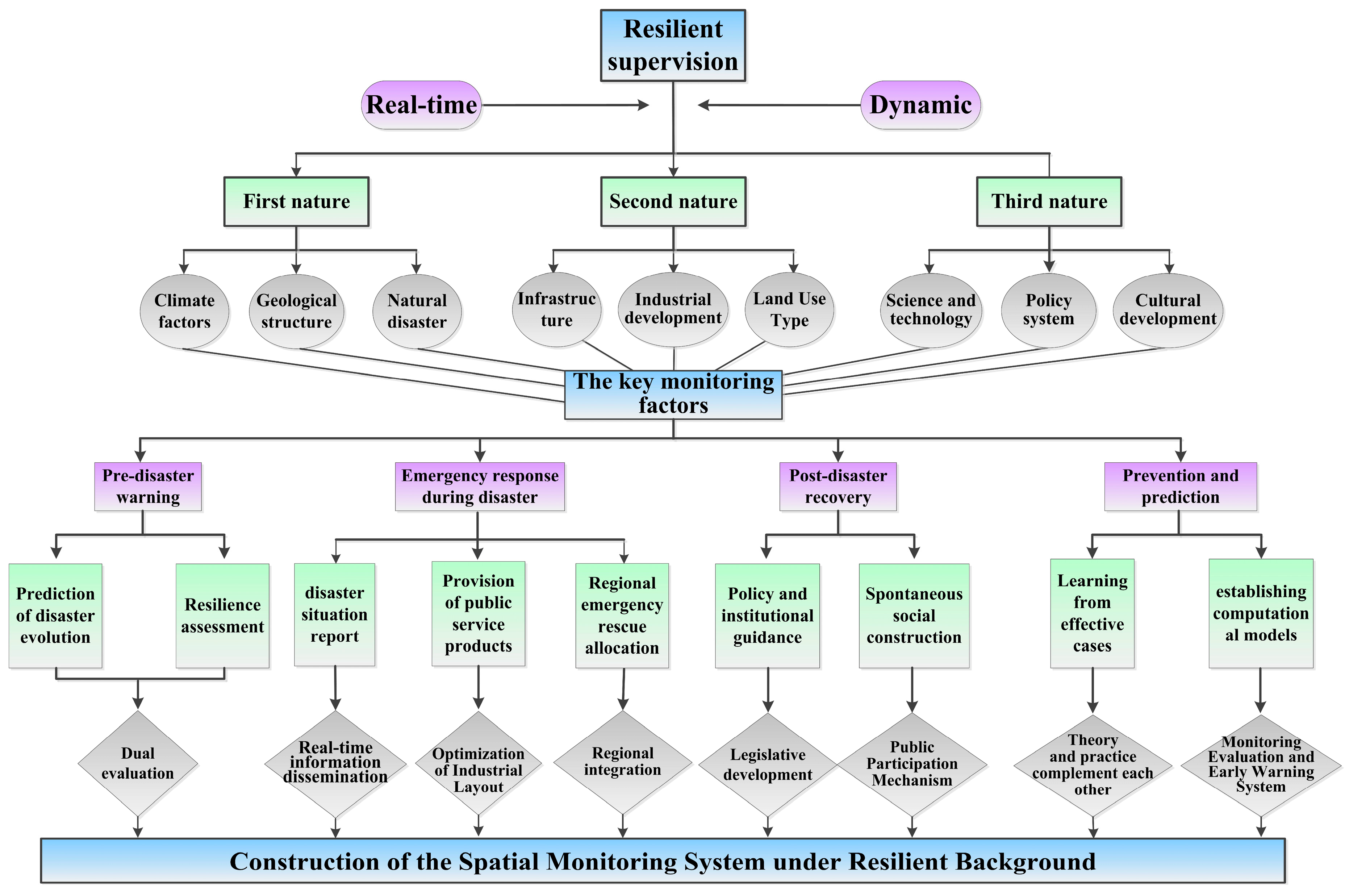
4.3. The System of Methodology and Technology

The construction of the monitoring and evaluation method for the resilience of the territorial space is mainly based on the structure and evolution mechanism of the territorial space system, and the complex characteristics of the territorial space system. The method evaluates the resilience of the territorial space from three aspects: environmental resilience, structural resilience, and element resilience. Firstly, natural resources and social economy are investigated, while social big data, remote sensing data, and geographic national conditions monitoring data are collected, and multiple data sources are standardized. Secondly, a five-level and three-category monitoring indicator system for territorial space planning is constructed. At the level, monitoring includes mountains, waters, fields, forests, lakes, grasses, sands, and the monitoring of national economic and social development. At the provincial level, monitoring includes resource and environmental carrying capacity, urban development boundary, ecological protection red line, permanent basic farmland, regional coordination, structural changes, ecological restoration, and major territorial comprehensive improvement projects. At the municipal level, the focus is on monitoring urban bottom line control, safety risks, and development status, and timely warning of major outstanding issues discovered by monitoring and evaluation.

5. Conclusions and Discussion

5.1. Discussion

In this paper, it is found that the resilience of land space is the result of the interaction of multiple systems, including natural, material, and social systems. Therefore, it is necessary to strengthen the mechanism and mechanism research of the interaction between various systems, and propose strategies to enhance the resilience of land space based on this. In addition, China’s modernization process is fast, and there are differences between China and developed countries in infrastructure construction and social capital accumulation. Therefore, comparative studies on land space protection and development and enhancing the resilience of land space under the context of Chinese and Western societies are needed. As a system of spatial planning, there is no standard model for its development, such as the localist decentralization reform in the UK. Against the backdrop of complex demands for land spatial interests, the downward shift of the focus of spatial planning has led to a pre decision-making process; The current spatial planning and operation logic in Germany is clear and the division of responsibilities is clear, but there are still certain deficiencies in the integration of spatial policies [42]. So it is even more necessary to formulate scientific and reasonable spatial planning based on the actual situation of the country, and monitor it closely in line with national development and changes.
Resilience is a broad concept and can easily become vague and abstract in the application process. Therefore, when integrating the concept of resilience into China’s spatial planning and monitoring, it is necessary to clarify the connotation and extension of the resilience concept, highlight the resilience focus and characteristics that should be possessed at all levels of spatial planning, and emphasize the collaboration among stakeholders. Resilient territorial space planning is an integrated system led by knowledge, supported by new planning ideas, theories, methods, technologies, and governance measures. It is necessary to integrate multiple disciplines such as planning, geography, information science, ecology, economics, sociology, etc., and achieve intelligent transformation by deeply integrating spatiotemporal information technology with planning technology. The construction of resilient land space is the result of the joint transformation, bidirectional drive, collaborative innovation and governance innovation of smart land [43] and intelligent planning. It requires multi-level, multi departmental, and cross regional administrative systems and planning governance, social governance oriented towards participation and action of multiple entities, and technological governance oriented towards the era of informatization, digitization, and intelligence.
This article explains the necessity of studying resilience at the national level, outlines the emergence and development of resilience thinking in spatial planning monitoring at home and abroad, as well as the results achieved. In response to the problems faced by China’s territorial space, this article explores how to construct a monitoring system from the perspectives of ideological theory, policies and regulations, and methods and technologies, which can serve as practical guidance. But China has a vast area, great regional differences, and different levels of development. Therefore, the deficiency of this paper is that it has not well discussed how to establish the monitoring system of territorial space implementation in different natural environments and development stages, which should be optimized in future research.

5.2. Conclusions

To enhance the resilience of national spatial planning, it is necessary to continuously improve the supervision and implementation system of national spatial planning based on actual situations. Monitoring implementers should shift from engineering thinking to system thinking, continuously introduce new technologies such as artificial intelligence, strengthen risk identification, carry out intelligent monitoring of land and space implementation, and enhance the governance capacity of land and space. Land development cannot be separated from the current social and economic situation, and “seeking truth from facts” is the fundamental guarantee for achieving sustainable development. The implementation of planning supervision policies is interdependent with national economic policies. The government should shift from leading to supporting and managing, using land use planning as a means to seek new economic growth engines for society. Based on the direction of the economy, land should be regulated to develop the economy, while considering a series of issues such as people’s livelihood, the environment, and disaster prevention, in order to enhance the resilience of land space.
A change in the perception of planning is needed at the conceptual level to achieve the overall goal of improving the resilience of land space [44]. The overall goal is to effectively control risks. The concept of “resilience” was originally introduced to address natural disasters, but with the growth of complexity and diversity of risks in modern society, it has evolved from single hazard risks to comprehensive risks, including various economic and social risks. Planning should gradually shift from engineering thinking to resilient thinking. The strategy of resilient response mainly includes enhancing risk identification and assessment, optimizing spatial systems, and ensuring spatial operations. At the same time, resilience emphasizes proactive adaptation rather than passive defense. The effective implementation of planning supervision requires an improvement in governance capabilities and the level of operation security [45]. In the future, the system of land space planning should no longer be a planning system, but should become a system centered on supervision and implementation. This is consistent with the transition of planning from managing increments to managing stocks. Planning should pay more attention to operability, and the role of spatial strategy depends on effective planning operations. A clear and accurate planning transmission system should be established, and the monitoring-evaluation-maintenance mechanism should be established to strengthen the control and response to various risks during the implementation process of planning.
Doing the above work well is beneficial for China to build a more harmonious human-land relationship and build a beautiful China. It is also beneficial for other countries to learn from experience and make greater contributions to global economic development and ecological environment protection.

Author Contributions

X.O. and S.C. conceived and designed the research; S.C. and C.Z. drafted the manuscript and prepared figures and revised the manuscript; X.O. And Y.H. discussed the results. All authors of this article have made corresponding contributions to the paper. All authors have read and agreed to the published version of the manuscript.

Funding

This research was funded by the Scientific Research Project of Hunan Provincial Education Department (grant number 22C0702); The Open Topic of Key Laboratory of Natural Resources Monitoring and Supervision in Southern Hilly Region, Ministry of Natural Resources (grant number NRMSSHR2022Y12); Science and Technology Project of Hunan Provincial Department of Land and Resources of China (grant number 2022-49).

Institutional Review Board Statement

Not applicable.

Informed Consent Statement

Not applicable.

Data Availability Statement

Not applicable.

Conflicts of Interest

The authors declare no conflict of interest.

References

  1. Heiman, D.; Suzanne, W.; Peter, W.; Hamed, K. Planning the resilient city: Investigations into using “causal loop diagram” in combination with “UNISDR scorecard” for making cities more resilient. Int. J. Disaster Risk Reduct. 2021, 65, 102561. [Google Scholar]
  2. Caldarice, O.; Tollin, N.; Pizzorni, M. The relevance of science-policy-practice dialogue. Exploring the urban climate resilience governance in Italy. City Territ. Arch. 2021, 8, 9. [Google Scholar] [CrossRef]
  3. Holling, C.S.; Gunderson, L. Resilience and adaptive cycles. In Panarchy: Understanding Transformations in Human and Natural Systems; OIRED: Blacksburg, VA, USA, 2002. [Google Scholar]
  4. Jabareen, Y. Planning the resilient city: Concepts and strategies for coping with climate change and environmental risk. Cities 2013, 31, 220–229. [Google Scholar]
  5. Erickson, T.A.; Meerow, S.; Hobbins, R.; Cook, E.; Iwaniec, D.M.; Berbés-Blázquez, M.; Grimm, N.B.; Barnett, A.; Cordero, J.; Gim, C.; et al. Beyond bouncing back? comparing and contesting urban resilience frames in us and latin american contexts. Landsc. Urban Plan. 2021, 214, 104173. [Google Scholar]
  6. Wen, J.; Liu, Y. Facing uncertainty: The dilemmas of social governance in China in the new stage of development and its response. J. Sci. Geo.-Graph. Sin. 2022, 42, 390–400. [Google Scholar]
  7. Fang, Y. Land Spatial Resilience Planning from the Perspective of Modernization of Provincial Governance. J. Theor. Mon. 2021, 12, 56–66. [Google Scholar]
  8. Meerow, S.; Newell, J.P.; Stults, M. Defining urban resilience: A review. Landsc. Urban Plan. 2016, 147, 38–49. [Google Scholar]
  9. Woodruff, S.C.; Meerow, S.; Stults, M.; Wilkins, C. Adaptation to resilience planning: Alternative pathways to prepare for climate change. J. Plan. Educ. Res. 2022, 42, 64–75. [Google Scholar] [CrossRef]
  10. Bush, J.; Doyon, A. Building urban resilience with nature-based solutions: How can urban planning contribute? Cities 2019, 95, 102483. [Google Scholar]
  11. Lemoine-Rodriguez, R.; Inostroza, L.; Zepp, H. Does Urban Climate Follow Urban Form? Analysing Intraurban LST Trajectories Versus Urban Form Trends in 3 Cities with Different Background Climates. Sci. Total Environ. 2022, 830, 154570. [Google Scholar]
  12. Sharifi, E.; Larbi, M.; Omrany, H.; Boland, J. Climate Change Adaptation and Carbon Emissions in Green Urban Spaces: Case Study of Adelaide. J. Clean. Prod. 2020, 254, 120035. [Google Scholar] [CrossRef]
  13. Adams, V.; Álvarez-Romero, J.; Capon, S.; Crowley, G.; Dale, A.; Kennard, M.; Douglas, M.; Pressey, R. Making Time for Space: The Critical Role of Spatial Planning in Adapting Natural Resource Management to Climate Change. Environ. Sci. Policy 2017, 74, 57–67. [Google Scholar] [CrossRef]
  14. The Press Office of the State Council of China. “Several Opinions on Establishing a Land and Space Planning System and Supervising Its Implementation” Press Conference, Recorded in Pictures and Text. 2019. Available online: https://climatecooperation.cn/climate/several-opinions-on-establishing-a-national-land-spatial-planning-system-and-supervising-its-implementation-published/ (accessed on 29 July 2023).
  15. Yang, X. Territorial Space Resilience: A Conceptual Framework and Its Implementation Path. J. Urban Plan. Forum. 2021, 3, 112–118. [Google Scholar]
  16. Zhai, G.; Xia, C. Strategic Focus on the Construction of Resilient Land Space in China. J. Urban Plan. 2021, 45, 44–48. [Google Scholar]
  17. Chen, Z.; Hu, J.; Wang, H. Reflections on the integration of resilient urban planning concepts into the national spatial planning system. J. Planner. 2021, 37, 72–76+92. [Google Scholar]
  18. Yan, W.; Ren, J.; Zhang, S.; He, L. Resilient Urban Planning in Shanghai: Key Issues, General Framework, and Planning Strategies. J. Urban Plan. Forum. 2022, 3, 19–28. [Google Scholar]
  19. Fang, Y. Scale and Resilience: Territorial and Spatial Planning Responses to Urban Risk Governance. J. Adm. Trib. 2022, 29, 121–131. [Google Scholar]
  20. Li, L.; Zhang, J.; Yang, J. Study on the General Ideas and the Key Technologies of Spatial Planning Implementation Monitoring. J. Geomat. World 2022, 29, 49–53, 60. [Google Scholar]
  21. Shi, X.; Yang, M.; Jin, Z.; Huang, H.; Luo, J.; Luo, X.; Zhang, W.; Deng, H.; Yang, J.; Sun, A. More Effective City Examination Assessment. J. City Plan. Rev. 2020, 44, 65–73. [Google Scholar]
  22. Lyu, Y.; Xiang, M.; Wang, M.; Wu, C. From disaster prevention to resilience construction: Exploration and prospect of resilience planning under the background of territorial governance. J. Nat. Resour. 2021, 36, 2281–2293. [Google Scholar] [CrossRef]
  23. Zhan, M.; Wang, L.; Wang, J. Monitoring, Assessment, and Warning Mechanism of National Land-space Plan, Guangzhou. J. Plan. 2020, 36, 65–70. [Google Scholar]
  24. Zhu, Y.; Wang, Z.; Zhu, X. New reflections on food security and land use strategies based on the evolution of Chinese dietary patterns. J. Land Use Policy 2023, 126, 106520. [Google Scholar] [CrossRef]
  25. Chen, Y. On Promoting the Conversion from Legal System of Public Health into Law-Ruling of Public Health. J. Law Sci. 2021, 17–37. [Google Scholar]
  26. Yao, S. City Rejuvenation Oriented to the Continuance of Right—Based on the Changing Logic from Livelihood to Life. J. Gansu Soc. Sci. 2022, 37–44. [Google Scholar]
  27. Yao, C.; Yu, L. Analysis of First Urban Planning Act and lts Supporting Act in Japan. J. Urban Plan. Int. 2017, 32, 94–100. [Google Scholar] [CrossRef]
  28. Zhang, J.; Luo, G. Exploring the Ideas and Methods of Supervision on the Implementation of Shenzhen’s Land Spatia Planning. J. Urban Rural. Plan. 2019, 6, 47–54. [Google Scholar]
  29. Chen, B.; Shen, D. Review of the Legal System of Protected Areas in German and Its Enlightenment to China. J. Urban Plan. Int. 2022, 37, 85–92. [Google Scholar]
  30. Wang, W.; Yang, Y. International Comparison and Enlightenment of National Spatial Planning Systems. J. Beijing Plan. Rev. 2020, 66–70. [Google Scholar]
  31. Deng, L.; Nan, M.; Liu, Y. Characters and Enlightenment of Land-space Plan in Germany. J. Plan. 2020, 36, 117–122. [Google Scholar]
  32. Liu, Z.; Yang, Q.; Wang, X. The characteristics and inspiration of local planning review in the context of planning reform in the UK. J. Urban Reg. Plan. 2022, 14, 193–205. [Google Scholar]
  33. Zhou, S.; Zhai, G.; Shi, Y. Indicator-Based Monitoring Framework of Spatial Planning in England and its Inspirations. J. Urban Plan. Int. 2018, 33, 126–131. [Google Scholar]
  34. Ongkowijoyo, C.S.; Doloi, H. Risk-based resilience assessment model focusing on urban infrastructure system restoration. J. Procedia Eng. 2018, 212, 1115–1122. [Google Scholar] [CrossRef]
  35. Chen, Q.; Wang, Z. Spatio-temporal Coupling and Interactive Effects of Land Development Intensity and Economic Resilience in the Wuling Mountains Area. J. Econ. Geogr. 2023, 43, 41–50. [Google Scholar]
  36. Yu, L.; Chen, C. Dilemma, reform, and reflections on spatial planning. J. City Plan. Rev. 2020, 44, 15–21. [Google Scholar]
  37. Wu, L. Application of Remote Sensing Technology in Data Processing of Mine Geological Surveying and Mapping. World Nonferrous Met. 2004, 99, 83–103. [Google Scholar]
  38. Cao, C.; Lu, T.; Li, P.; Qian, Z.; Jin, X.; Leng, B.; Liu, Y.; Tan, L. Monitoring, Evaluation, and Early Warning of territorial space Planning: Concepts, Tasks, and the Technical Framework. J. Urban Plan. 2022, 88–94. [Google Scholar]
  39. Krugman, P.R. First nature, second nature, and metropolitan location. J. Reg. Sci. 1993, 33, 129–144. [Google Scholar] [CrossRef]
  40. Liu, Q.; Wang, Z. Research on geographical elements of economic difference in China. J. Geogr. Res. 2009, 28, 430–440. [Google Scholar]
  41. Li, H.; Liu, S. Research Progress of “Double Evaluation” under China’s Land Spatial Planning. J. Anhui Agric. Sci. 2022, 50, 13–17. [Google Scholar]
  42. Zhou, Y. The Management and Coordination of Spatial Elements of Super-local Spatial Planning, Urban Planning and Sectoral Planning in Germany. J. Urban Plan. Int. 2021, 36, 99–108. [Google Scholar]
  43. Zhou, S.; Lai, P. Urban Security Resilience and Smart Governance of Territorial Space in Society 5.0. J. Plan. 2023, 39, 5–12. [Google Scholar]
  44. Dong, Z. From Land-Use Planning to Territorial Space Planning: A Perspective of Scientific and Rational Planning. J. China Land Sci. 2020, 34, 1–7. [Google Scholar]
  45. Chen, L.; Jiang, H. Territorial spatial planning: Development history, governance status, and regulatory strategies. J. Chin. J. Agric. Resour. Reg. Plan. 2021, 42, 61–68. [Google Scholar]
Figure 1. Logical Relationship between resilient territorial space and planning monitoring.
Sustainability 15 14682 g001
Figure 2. Monitoring system for territorial space implementation under the background of resilience.
Sustainability 15 14682 g002
Disclaimer/Publisher’s Note: The statements, opinions and data contained in all publications are solely those of the individual author(s) and contributor(s) and not of MDPI and/or the editor(s). MDPI and/or the editor(s) disclaim responsibility for any injury to people or property resulting from any ideas, methods, instructions or products referred to in the content.

