
Seismic Microzonation Mapping for Urban and Land Sustainable Planning in High Seismicity Areas (L’Aquila Municipality, Central Italy): The Contribution of 2D Modeling for the Evaluation of the Amplification Factors

 ,
,  ,
,  , and
, and
Abstract
:1. Introduction
- Sustainable urban planning: based on the information provided by SM, urban development can be planned to optimize construction costs and minimize potential economic and social costs (in probabilistic terms) to the population in terms of damage to people and infrastructures in case of a seismic event.
- Seismic risk reduction: SM identifies areas with greater seismic vulnerability, allowing for more targeted and effective seismic risk prevention and mitigation measures.
- Protection of historical and cultural heritage: SM can be used to protect historical and cultural heritage from seismic damage by identifying areas where specific intervention measures are needed.
- Post-earthquake reconstruction: in case of an earthquake, SM provides valuable information for reconstruction planning, allowing resources to be directed to the most potentially affected areas.
2. Geological Setting of Plio–Quaternary L’Aquila Basin (LAB)
3. Materials and Methods
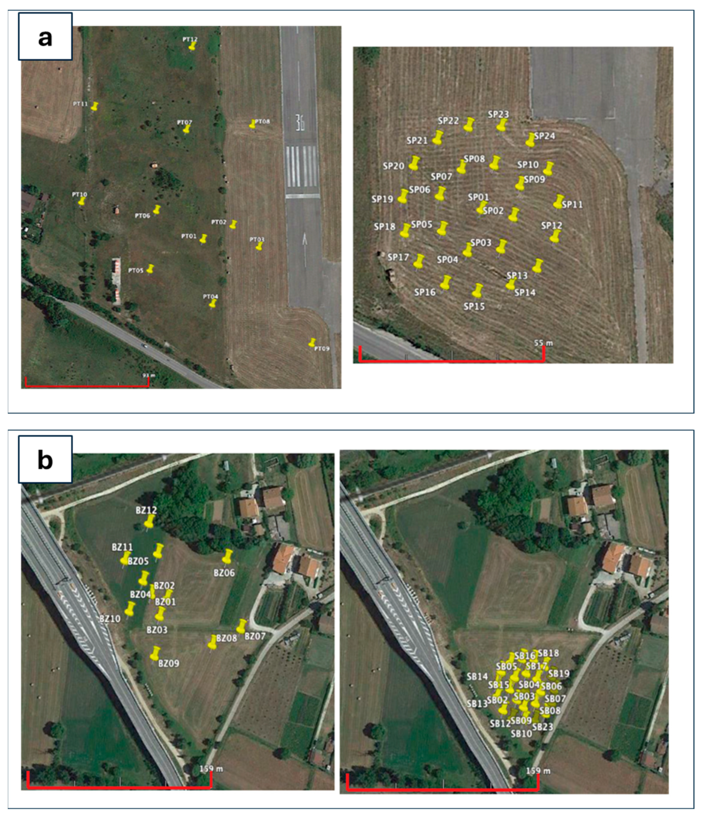
3.1. Database Set Up
3.2. The 2D Microtremor Arrays
3.3. Seismic Input
3.4. Computer Code Selection
3.5. Third-Level MS Mapping
4. Results
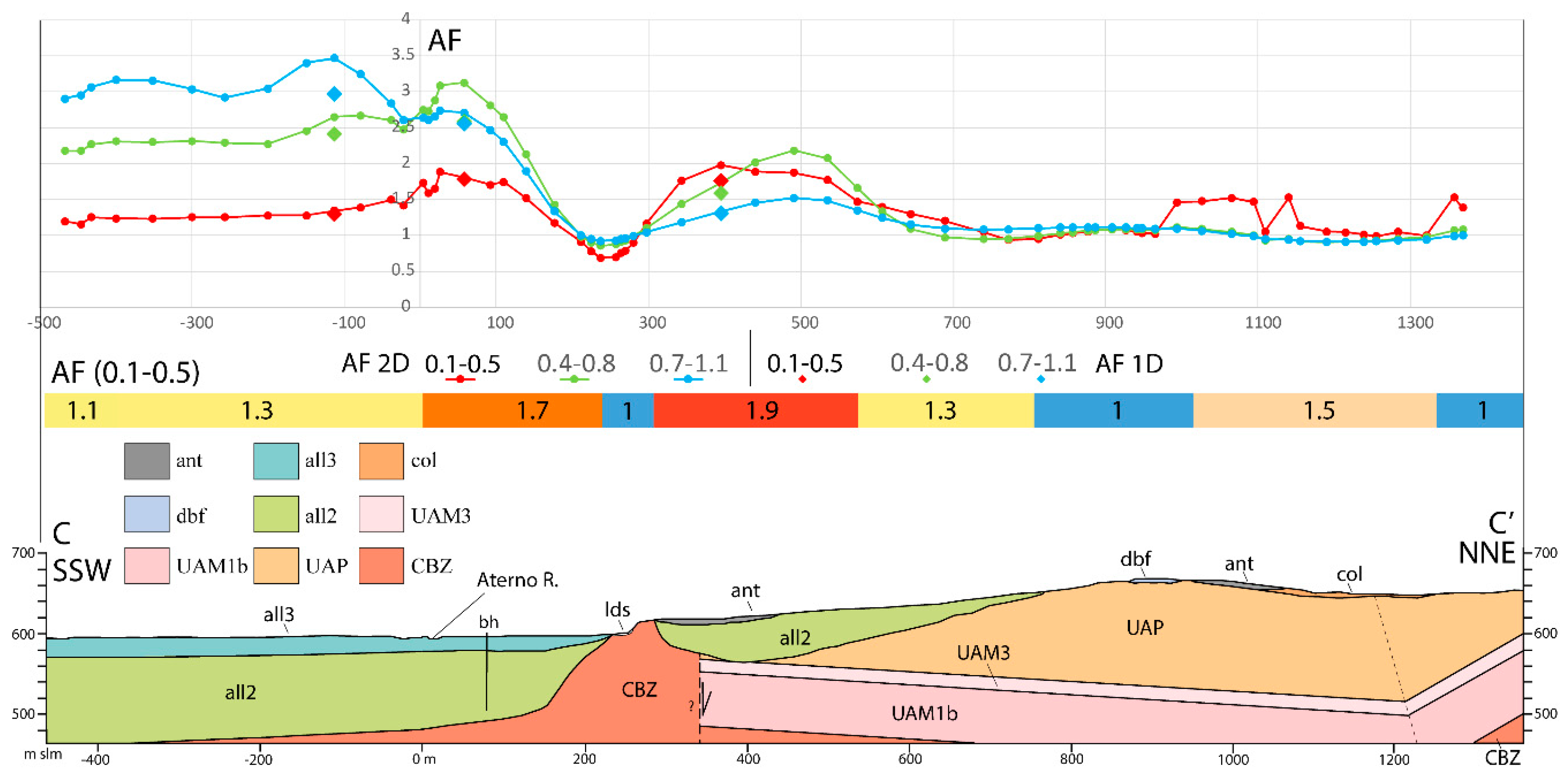
5. Discussions
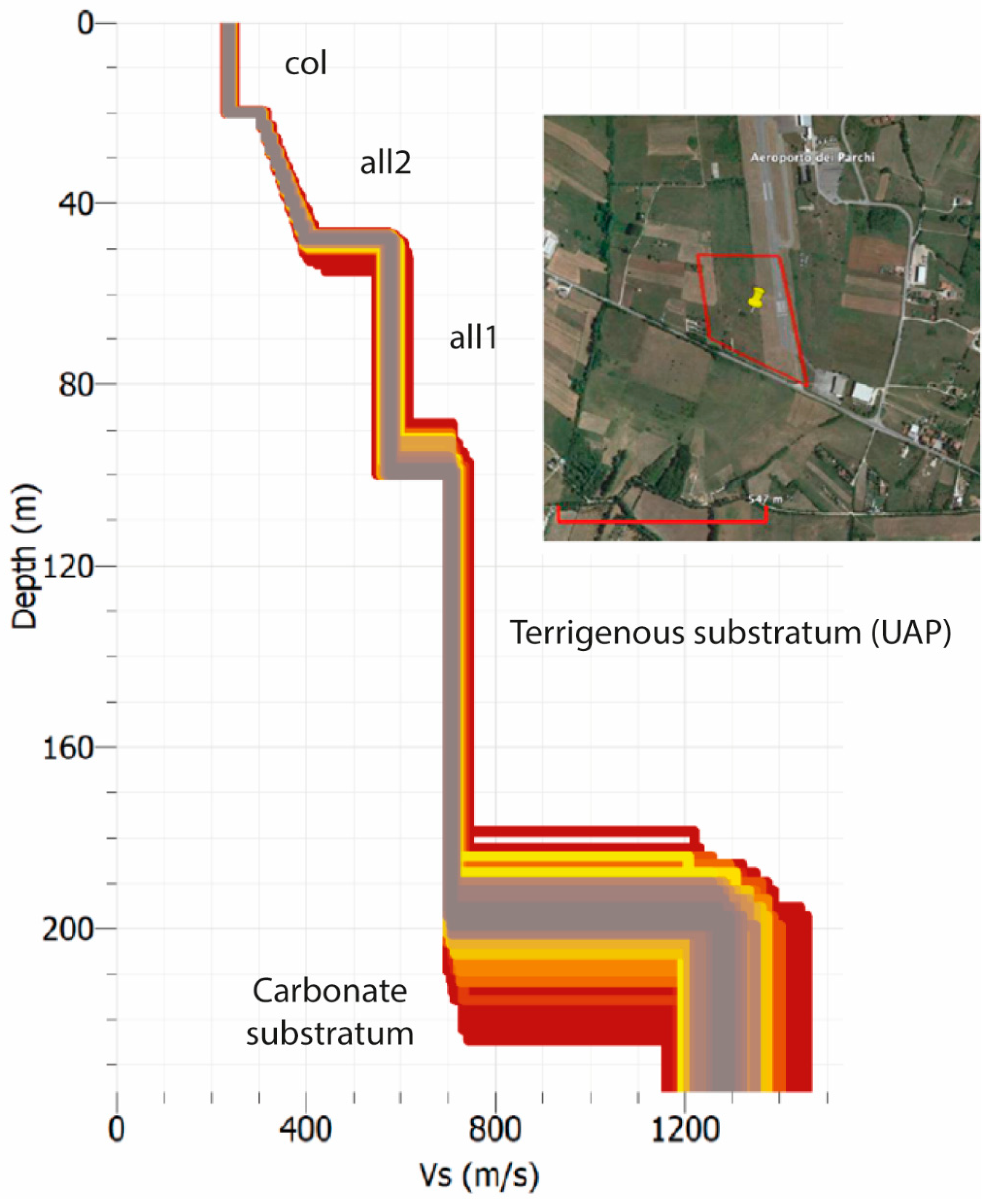
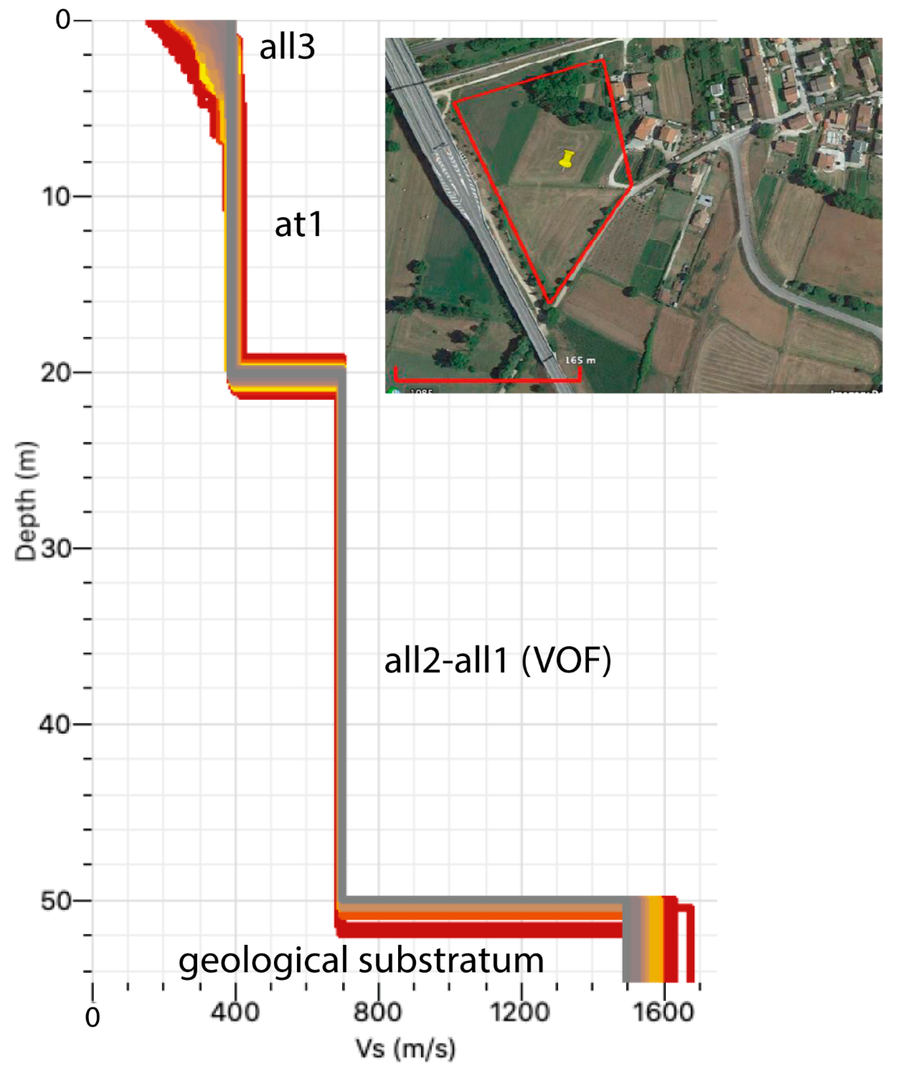
5.1. The Subsoil Model
5.1.1. Preturo–Sassa Area
5.1.2. Bazzano–Monticchio Area
5.2. The Numerical Modelling and Third-Level SM Deliverables
5.3. Model Validation
6. Conclusions
Author Contributions
Funding
Institutional Review Board Statement
Informed Consent Statement
Data Availability Statement
Acknowledgments
Conflicts of Interest
References
- Adhikari, S.R.; Molnar, S.; Wang, J. Seismic microzonation mapping of Greater Vancouver based on various site classification metrics. Front. Earth Sci. 2023, 11, 1221234. [Google Scholar] [CrossRef]
- Bıçakcı, G.B.; Özçep, F.; Karabulut, S.; Cengiz, M. The Importance of seismic microzonation under the threat of an earthquake of the north anatolian fault in nilüfer, bursa, turkey. J. Appl. Geophys. 2024, 229, 105489. [Google Scholar] [CrossRef]
- Chen, G.; Magistrale, H.; Rong, Y.; Cheng, J.; Ahmet Binselam, S.; Xu, X. Seismic site condition of Mainland China from geology. Seism. Soc. Am. 2021, 92, 998–1010. [Google Scholar] [CrossRef]
- Fäh, D.; Rüttener, E.; Noack, T.; Kruspan, P. Microzonation of the city of Basel. J. Seism. 1997, 1, 87–102. [Google Scholar] [CrossRef]
- Licata, V.; Forte, G.; d’Onofrio, A.; Santo, A.; Silvestri, F. A multi-level study for the seismic microzonation of the Western area of Naples (Italy). Bull. Earthq. Eng. 2019, 17, 4711–4741. [Google Scholar] [CrossRef]
- SM Working Group. Guidelines for Seismic Microzonation, Conference of Regions and Autonomous Provinces of Italy; Civil Protection Department: Rome, Italy, 2008; pp. 1–124. Available online: https://www.centromicrozonazionesismica.it/documents/18/GuidelinesForSeismicMicrozonation.pdf (accessed on 6 September 2024).
- CS.LL.PP. Aggiornamento delle Norme Tecniche per le Costruzioni [Improvement of Technical Standards for Construction]. Gazzetta Ufficiale della Repubblica Italiana 2018; p. 42. Available online: https://www.gazzettaufficiale.it/eli/id/2018/2/20/18A00716/sg (accessed on 6 September 2024).
- Kramer, S.L. Geotechnical Earthquake Engineering; Pearson Education India: Chennai, India, 1996. [Google Scholar]
- Sucuoglu, H.; Akkar, S. Basic Earthquake Engineering: From Seismology to Analysis and Design; Springer: Cham, Switzerland, 2014; Volume 1, ISBN 9783319010250. [Google Scholar]
- Yoshida, N. Seismic Ground Response Analysis; Springer: Berlin/Heidelberg, Germany, 2015; Volume 36, ISBN 978-94-017-9460-2. [Google Scholar]
- Nocentini, M.; Asti, R.; Cosentino, D.; Durante, F.; Gliozzi, E.; Macerola, L.; Tallini, M. Plio-Quaternary geology of L’Aquila–Scoppito Basin (Central Italy). J. Maps 2017, 13, 563–574. [Google Scholar] [CrossRef]
- Chiarabba, C.; Amato, A.; Anselmi, M.; Baccheschi, P.; Bianchi, I.; Cattaneo, M.; Cecere, G.; Chiaraluce, L.; Ciaccio, M.G.; De Gori, P.; et al. The 2009 L’Aquila (central Italy) MW6.3 earthquake: Main shock and aftershocks. Geophys. Res. Lett. 2009, 6, 18308. [Google Scholar] [CrossRef]
- Wang, L.; Nagarajaiah, S.; Zhou, Y.; Shi, W. Seismic performance improvement of base-isolated structures using a semi-active tuned mass damper. Eng. Struct. 2022, 271, 114963. [Google Scholar] [CrossRef]
- Wang, L.; Zhou, Y.; Shi, W. Seismic Response Control of a Nonlinear Tall Building Under Mainshock-Aftershock Sequences Using Semi-Active Tuned Mass Damper. Int. J. Struct. Stab. Dyn. 2023, 23, 2340027. [Google Scholar] [CrossRef]
- Bisch, P.; Carvalho, E.; Degee, H.; Fajfar, P.; Fardis, M.; Franchin, P.; Kreslin, M.; Pecker, A.; Pinto, P.; Plumier, A.; et al. Eurocode 8: Seismic Design of Buildings Worked Examples; Publications Office of the European Union: Luxembourg, 2012; Available online: http://www.jrc.ec.europa.eu/ (accessed on 6 September 2024).
- Carminati, E.; Lustrino, M.; Cuffaro, M.; Doglioni, C. Tectonics, magmatism and geodynamics of Italy: What we know and what we imagine. J. Virtual Explor. 2010, 36, 9. [Google Scholar] [CrossRef]
- Cavinato, G.P.; De Celles, P.G. Extensional basins in the tectonically bimodal central Apennines fold-thrust belt, Italy: Response to corner flow above a subducting slab in retrograde motion. Geology 1999, 27, 955–958. [Google Scholar] [CrossRef]
- Barchi, M.; Galadini, F.; Lavecchia, G.; Messina, P.; Michetti, A.M.; Peruzza, L.; Pizzi, A.; Tondi, E.; Vittori, E. Sintesi Delle Conoscenze Sulle Faglie Attive in Italia Centrale: Parametrizzazione ai Fini Della Caratterizzazione Della Pericolosità Sismica [Summary of Knowledge on Active Faults in Central Italy: Parameterization for the Purposes of Characterizing Seismic Hazard]; CNR Gruppo Nazionale per la Difesa dai Terremoti: Roma, Italy, 2000; p. 62. Available online: https://www.researchgate.net/profile/Paolo-Messina-4/publication/235233363_Sintesi_delle_Conoscenze_Sulle_Faglie_Attive_in_Italia_Centrale_Parametrizzazione_ai_Fini_della_Caratterizzazione_della_Pericolosita_Sismica/links/02e7e53287abc91669000000/Sintesi-delle-Conoscenze-Sulle-Faglie-Attive-in-Italia-Centrale-Parametrizzazione-ai-Fini-della-Caratterizzazione-della-Pericolosita-Sismica.pdf (accessed on 6 September 2024).
- Boncio, P.; Lavecchia, G.; Pace, B. Defining a model of 3D seismogenic sources for seismic hazard assessment applications: The case of central Apennines (Italy). J. Seism. 2004, 8, 407–425. [Google Scholar] [CrossRef]
- Devoti, R.; Pietrantonio, G.; Pisani, A.; Riguzzi, F.; Serpelloni, E. Present day kinematics of Italy. J. Virtual Explor. 2010, 36, 2. [Google Scholar] [CrossRef]
- Pondrelli, S.; Salimbeni, S.; Ekstrom, G.; Morelli, A.; Gasperini, P.; Vannucci, G. The Italian CMT dataset from 1977 to the present. Phys. Earth Planet. Inter. 2006, 159, 286–303. [Google Scholar] [CrossRef]
- Galadini, F.; Galli, P. Active tectonics in the central Apennines (Italy) and input data for seismic hazard assessment. Nat. Hazards 2000, 22, 225–270. [Google Scholar] [CrossRef]
- Sciortino, A.; Marini, R.; Guerriero, V.; Mazzanti, P.; Spadi, M.; Tallini, M. Satellite A-DInSAR pattern recognition for seismic vulnerability mapping at city scale: Insights from the L’Aquila (Italy) case study. GIScience Remote Sens. 2024, 61, 1. [Google Scholar] [CrossRef]
- Sciortino, A.; Guerriero, V.; Marini, R.; Spadi, M.; Mazzanti, P.; Tallini, M. Geological and Hydrogeological Drivers of Seismic Deformation in L’Aquila, Italy: Insights from InSAR Analysis. Geomat. Nat. Hazards Risk 2024, 15, 2362395. [Google Scholar] [CrossRef]
- Abruzzo Seismic Microzonation Working Group. Standard di Rappresentazione Cartografica e Archiviazione Informatica. Specifiche Tecniche per la Redazione Degli Elaborati Cartografici ed Informatici Relativi al Primo Livello Delle Attività di Microzonazione Sismica [Standard of Cartographic Representation and Geodatabase Archiving. Technical Specifications for First Level Seismic Microzonation Mapping], ver. 1.2, L’Aquila. 2012. Available online: https://protezionecivile.regione.abruzzo.it/agenzia/files/rischio%20sismico/microzonazione/OPCM3907/LineeGuidaMS_v1_2_ONLINE2.pdf (accessed on 6 September 2024).
- APAT (2006)–Sheet 359 “L’Aquila”. APAT–Servizio Geologico d’Italia e Regione Abruzzo–Servizio Difesa del Suolo, S.EL.CA., Firenze. Available online: https://www.isprambiente.gov.it/Media/carg/359_LAQUILA/Foglio.html (accessed on 6 September 2024).
- APAT (2008)–Sheet 358 “Pescorocchiano”. APAT–Servizio Geologico d’Italia, S.EL.CA., Firenze. Available online: https://www.isprambiente.gov.it/Media/carg/358_PESCOROCCHIANO/Foglio.html (accessed on 6 September 2024).
- Cosentino, G.; Pennica, F.; Tarquini, E.; Stigliano, F.; Coltella, M. Manuale per l’utilizzo del plugin “MzS Tools” con Licenza Creative Commons Attribuzione 4.0 Internazionale. 2022. Available online: https://github.com/CNR-IGAG/mzs-tools (accessed on 6 September 2024).
- Tokimatsu, K. Geotechnical site characterization using surface waves. In Proceedings of the IS-Tokyo 95, The First International Conference on Earthquake Geotechnical Engineering, Tokyo, Japan, 14 November 1995. [Google Scholar]
- Foti, S.; Parolai, S.; Bergamo, P.; Di Giulio, G.; Maraschini, M.; Milana, G.; Picozzi, M.; Puglia, R. Surface wave surveys for seismic site characterization of accelerometric stations in ITACA. Bull. Earthq. Eng. 2011, 9, 1797–1820. [Google Scholar] [CrossRef]
- Di Giulio, G.; Gaudiosi, I.; Cara, F.; Milana, G.; Tallini, M. Shear-wave velocity profile and seismic input derived from ambient vibration array measurements: The case study of downtown L’Aquila. Geophys. J. Int. 2014, 198, 848–866. [Google Scholar] [CrossRef]
- Lacoss, R.T.; Kelly, E.J.; Toksoz, M.N. Estimation of seismic noise structure using arrays. Geophysics 1969, 34, 21–38. [Google Scholar] [CrossRef]
- Bettig, B.; Bard, P.-Y.; Scherbaum, F.; Riepl, J.; Cotton, F.; Cornou, C.; Hatzfeld, D. Analysis of dense array measurements using the modified spatial auto-correlation method (SPAC). Appl. Grenoble Area. Bol. Geofis. Teor. E Appl. 2001, 42, 281–304. Available online: https://epsc.wustl.edu/~ggeuler/reading/cam_noise_biblio/bettig_bard_scherbaum_riepl_cotton_cornou_and_hatzfeld_2001-bgta-analysis_of_dense_array_noise_measurements_using_the_modified_spatial_auto-correlation_method_spac_-_application_to_the_grenoble_area.pdf (accessed on 6 September 2024).
- Iervolino, I.; Galasso, C.; Cosenza, E. REXEL: Computer aided record selection for code-based seismic structural analysis. Bull. Earthq. Eng. 2009, 8, 339–362. [Google Scholar] [CrossRef]
- Sgobba, S.; Puglia, R.; Pacor, F.; Luzi, L.; Russo, E.; Felicetta, C.; Lanzano, G.; D’Amico, M.; Baraschino, R.; Baltzopoulos, G.; et al. REXELweb: A tool for selection of ground-motion records from the Engineering Strong Motion database (ESM). In Earthquake Geotechnical Engineering for Protection and Development of Environment and Constructions; CRC Press: Boca Raton, FL, USA, 2019; pp. 4947–4953. [Google Scholar]
- SM Working Group. Informatic Representation and Archiving Standards. Seismic Microzonation. Version 4.2. Conference of Regions and Autonomous Provinces of Italy; Civil Protection Department: Rome, Italy, 2020; pp. 1–138. Available online: https://www.webms.it/sites/default/files/2018-06/StandardMS_4_2.pdf (accessed on 6 September 2024).
- Kottke, A.R.; Rathje, E.M. Technical Manual for Strata; PEER Report 2008/10; Pacific Earthquake Engineering Research Center, University of California: Berkeley, CA, USA, 2009; pp. 1–103. [Google Scholar]
- Cardarelli, E.; Cercato, M. Relazione Sulla Campagna D’indagine Geofisica per lo Studio Della Risposta Sismica Locale Della Città Dell’aquila, Prova Crosshole, Sondaggi S3-S4 [Report on the Geophysical Survey Campaign for the Study of the Local Seismic Response of the City of L’Aquila, Crosshole Test, Boreholes S3-S4]; Report for CERFIS; La Sapienza University of Rome: Roma, Italy, 2010; 13p. [Google Scholar]
- Lanzo, G.; Tallini, M.; Milana, G.; Di Capua, G.; Del Monaco, F.; Pagliaroli, A.; Peppoloni, S. The Aterno Valley strong-motion array: Seismic characterization and determination of subsoil model. Bull. Earthq. Eng. 2011, 9, 1855–1875. [Google Scholar] [CrossRef]
- Durante, F.; Di Giulio, G.; Tallini, M.; Milana, G.; Macerola, L. A multidisciplinary approach to the seismic characterization of a mountain top (Monteluco, central Italy). Phys. Chem. Earth Parts A/B/C 2017, 98, 119–135. [Google Scholar] [CrossRef]
- Seed, H.B.; Wong, R.T.; Idriss, I.M.; Tokimatsu, K. Moduli and damping factors for dynamic analyses of cohesionless soils. J. Geotech. Eng. 1986, 112, 1016–1032. [Google Scholar] [CrossRef]
- Rollins, K.M.; Evans, M.D.; Diehl, N.B.; Daily, W.D., III. Shear modulus and damping relationships for gravels. J. Geotech. Geoenvironmental Eng. 1998, 124, 396–405. [Google Scholar] [CrossRef]
- MS-AQ Working Group. Seismic Microzonation for the Reconstruction of L’Aquila. 2010. Available online: https://www.protezionecivile.gov.it/it/pubblicazione/microzonazione-sismica-la-ricostruzione-dellarea-aquilana/ (accessed on 6 September 2024).
- Modoni, G.; Gazzellone, A. Simplified theoretical analysis of the seismic response of artificially compacted gravels. In Proceedings of the 5th International Conference on Recent Advances in Geotechnical Earthquake Engineering and Soil Dynamics, San Diego, CA, USA, 26 May 2010. Paper No. 1.28a. [Google Scholar]
- Lanzo, G.; Silvestri, F. Risposta Sismica Locale: Teoria ed Esperienze; Hevelius Edizioni: Benevento, Italy, 1999; pp. 1–159. [Google Scholar]
- Cosentino, G.; Pennica, F. Manuale D’uso Del Plugin MzS Tools [MzS Tools Plugin User Manual]. 2022. Available online: https://mzs-tools.readthedocs.io/it/latest/intro.html (accessed on 6 September 2024).
- Pergalani, F.; Pagliaroli, A.; Bourdeau, C.; Compagnoni, M.; Lenti, L.; Lualdi, M.; Madiai, C.; Martino, S.; Razzano, R.; Varone, C.; et al. Seismic microzoning map: Approaches, results and applications after the 2016-2017 Central Italy seismic sequence. Bull. Earthq. Eng. 2020, 18, 5595–5629. [Google Scholar] [CrossRef]


| Unit Code (+) | Synthem/Formation (*) | Age |
|---|---|---|
| ant | - | Holocene |
| fra | Aterno Synthem | Holocene |
| fal | Aterno Synthem | Holocene |
| all3 | Aterno Synthem | Holocene |
| col | Aterno Synthem | Holocene; Upper Pleistocene (upper part) |
| at3 | Ponte Peschio Synthem | Upper Pleistocene (upper part) |
| at2 | Fosso Vetoio Synthem | Upper Pleistocene (upper part) |
| dbf | Colle Macchione–L’Aquila Synthem | Middle Pleistocene (upper part) |
| at1 | Fosso Genzano Synthem | Middle Pleistocene (lower part) |
| ver | San Marco Formation (Preturo–Sassa area) | Calabrian (lower part) |
| all2 | Madonna della Strada Formation | Calabrian (lower-middle part) |
| all1 | Colle Cantaro-Cave Formation (Preturo–Sassa area) | upper Piacenzian–Gelasian |
| all1 | Valle Orsa Formation (Bazzano–Monticchio area) | upper Piacenzian–Gelasian |
| ver | Valle Valiano Formation (Bazzano–Monticchio area) | upper Piacenzian–Gelasian |
| UAP, UAM, UAM3, UAM1b | terrigenous substratum | upper Miocene |
| CBZ and many other codes | carbonate substratum | middle Miocene–upper Jurassic |
| Unit Code (+) | Depositional Environment | Grain Size and Rock Mass Characteristics |
|---|---|---|
| ant | anthropic deposit | mainly gravel |
| fra | landslide deposit | mainly gravel |
| fal | slope deposit | mainly gravel |
| all3 | fluvial deposit | sand and gravel |
| col | colluvium | sandy and gravelly clay, sand |
| at3 | terraced fluvial deposit | gravel |
| at2 | terraced fluvial deposit | gravel |
| dbf | rock avalanche–debris flow deposit | massive calcareous breccia |
| at1 | terraced fluvial deposit | gravel |
| ver | slope deposit San Marco Formation (Preturo–Sassa area) | massive calcareous breccia |
| all2 | fluvial deposit | clay |
| all1 | fluvial deposit (Preturo–Sassa area) | gravel |
| all1 | fluvial (Gilbert-type fan delta) deposit Valle Orsa Formation (Bazzano–Monticchio area) | gravel |
| ver | slope deposit Valle Valiano Formation (Bazzano–Monticchio area) | stratified breccia |
| UAP, UAM, UAM3, UAM1b | siliciclastic foredeep turbidites and hemipelagic pelite | alternation of different stratified arenaceous–marly–clayey lithologies |
| CBZ and many other codes | carbonate rocks (ramp, slope-to-basin, and reef environment) | mainly stratified carbonate lithologies |
| Unit Code (+) | Vs (m/s) | Unit Weight (kN/m3) | Poisson’s Ratio | G/G0-γ and D-γ Decay Curves |
|---|---|---|---|---|
| ant | 250 | 17 | 0.2 | gravel medium model by [42] |
| fra | 300 | 20 | 0.4 | gravel medium model by [42] |
| fal | 300 | 20 | 0.4 | gravel medium model by [42] |
| all3 | sand: 250 gravel: 300 | 19 | 0.2 | sand model (upper–lower) by [41] gravel medium model by [42] |
| col | 250 | 19 | 0.2 | sand model (upper–lower) by [41] |
| at3 | 400 | 19 | 0.2 | gravel medium model by [42] |
| at2 | 400 | 19 | 0.2 | gravel medium model by [42] |
| dbf | 800 | 20 | 0.2 | model by [44] |
| at1 | 500 | 21 | 0.2 | gravel medium model by [42] |
| ver | 1200 | 21 | 0.2 | elastic linear (damping: 0.5%) |
| all2 | 450 (Preturo–Sassa area) 450 (0–30 m) 600 (30–60 m) 700 (60–120 m) 750 (110–160 m) 800 (>160 m) (Bazzano–Monticchio area) | 19 | 0.2 | experimental data by sample S3 C3 Cese di Preturo [43] |
| all1 | 800 | 20 | 0.2 | gravel medium model by [42] |
| UAP, UAM, UAM3, UAM1b | 800 | 22 | 0.2 | elastic linear (damping: 0.5%) |
| carbonate rocks SCZ, CBZ, etc. | 1250 | 22 | 0.2 | elastic linear (damping: 0.5%) |
| Main Seismic Boundary (+) | Vs (m/s) | Thickness (m) | Depth (m bgl) | Average Vs (m/s) with Respect to Depth | Evaluated Resonance Frequency (Hz) | Measured Resonance Frequency (Hz) |
|---|---|---|---|---|---|---|
| bottom col | 200 | 20 | 20 | 200 | 2.5 | 2.5–10 |
| bottom all2 | 350 | 30 | 50 | 310 | 1.5 | 1.0–1.5 |
| bottom all1 | 500 | 50 | 100 | 405 | 1.0 | 1.0–1.5 |
| bottom UAP | 700 | 100 | 200 | 552 | 0.7 | 0.4–0.7 |
| Main Seismic Boundary (+) | Vs (m/s) | Thickness (m) | Depth (m bgl) | Average Vs (m/s) with Respect to Depth | Evaluated Resonance Frequency (Hz) | Measured Resonance Frequency (Hz) |
|---|---|---|---|---|---|---|
| bottom all3 | 250 | 4 | 4 | 250 | 16 | - |
| bottom at1 | 500 | 16 | 20 | 450 | 5.6 | 4–5 |
Disclaimer/Publisher’s Note: The statements, opinions and data contained in all publications are solely those of the individual author(s) and contributor(s) and not of MDPI and/or the editor(s). MDPI and/or the editor(s) disclaim responsibility for any injury to people or property resulting from any ideas, methods, instructions or products referred to in the content. |
© 2024 by the authors. Licensee MDPI, Basel, Switzerland. This article is an open access article distributed under the terms and conditions of the Creative Commons Attribution (CC BY) license (https://creativecommons.org/licenses/by/4.0/).
Share and Cite
Tallini, M.; Morana, E.; Guerriero, V.; Di Giulio, G.; Vassallo, M. Seismic Microzonation Mapping for Urban and Land Sustainable Planning in High Seismicity Areas (L’Aquila Municipality, Central Italy): The Contribution of 2D Modeling for the Evaluation of the Amplification Factors. Sustainability 2024, 16, 8401. https://doi.org/10.3390/su16198401
Tallini M, Morana E, Guerriero V, Di Giulio G, Vassallo M. Seismic Microzonation Mapping for Urban and Land Sustainable Planning in High Seismicity Areas (L’Aquila Municipality, Central Italy): The Contribution of 2D Modeling for the Evaluation of the Amplification Factors. Sustainability. 2024; 16(19):8401. https://doi.org/10.3390/su16198401
Chicago/Turabian StyleTallini, Marco, Enrico Morana, Vincenzo Guerriero, Giuseppe Di Giulio, and Maurizio Vassallo. 2024. "Seismic Microzonation Mapping for Urban and Land Sustainable Planning in High Seismicity Areas (L’Aquila Municipality, Central Italy): The Contribution of 2D Modeling for the Evaluation of the Amplification Factors" Sustainability 16, no. 19: 8401. https://doi.org/10.3390/su16198401