Review

Water Footprint of Cities: A Review and Suggestions for Future Research

1
Department of Civil and Environmental Engineering, The Pennsylvania State University, University Park, State College, PA 16802, USA
2
Fulton School of Engineering, Arizona State University, Tempe, AZ 85281, USA
3
Department of Civil and Environmental Engineering, University of Illinois at Urbana Champaign, 205 N. Mathews Ave, Urbana, IL 61801, USA
4
Departamento de Ingeniería Hidráulica y Ambiental, Pontificia Universidad Católica de Chile, Av. Vicuña Mackenna 4860, Santiago 7820436, Chile
5
Centro de Desarrollo Urbano Sustentable CONICYT/FONDAP/15110020, Av. Vicuña Mackenna 4860, Santiago 7820436, Chile
6
Centro Interdisciplinario de Cambio Global, Pontificia Universidad Católica de Chile, Av. Vicuña Mackenna 4860, Santiago 7820436, Chile
7
Imperial College London, SW7 2AZ London, UK
*
Author to whom correspondence should be addressed.
Sustainability 2015, 7(7), 8461-8490; https://doi.org/10.3390/su7078461
Submission received: 28 March 2015 / Revised: 20 June 2015 / Accepted: 24 June 2015 / Published: 30 June 2015
(This article belongs to the Special Issue Water Footprints and Sustainable Water Allocation)

Abstract

:
Cities are hotspots of commodity consumption, with implications for both local and systemic water resources. Water flows “virtually” into and out of cities through the extensive cross-boundary exchange of goods and services. Both virtual and real water flows are affected by water supply investments and urban planning decisions, which influence residential, commercial, and industrial development. This form of water “teleconnection” is being increasingly recognized as an important aspect of water decision-making. The role of trade and virtual water flows as an alternative to expanding a city’s “real” water supply is rarely acknowledged, with an emphasis placed instead on monotonic expansion of engineering potable water supplies. We perform a literature review of water footprint studies to evaluate the potential and importance of taking virtual flows into account in urban planning and policy. We compare and contrast current methods to assess virtual water flows. We also identify and discuss priorities for future research in urban water footprint analysis.

“Water flows uphill to money”
—Western U.S. Folklore

1. Introduction

Cities are the hub of global economic forces [1,2,3] with their links to distant and proximate locations through extensive exchange networks. Globally, cities are home to more than half of the world’s population and are expected to support nearly two-thirds by 2050 [4]. While this increased urbanization has come to signify greater socioeconomic opportunity and improved social welfare [5,6], it is also creating additional stress on our water resources and the ecosystems they support [7,8,9,10]. This is further compounded by the environmental degradation that can result from aging and/or inadequate water infrastructure in cities [11,12,13,14]. Thus, it is becoming increasingly clear that cities hold the key to achieving sustainability targets because of their potential to address, and have an impact on global issues revolving around climate change [15,16,17], biodiversity loss [18,19,20], and water resources [21,22,23,24,25,26].
To track the trajectory and assess the resilience of pathways toward urban sustainability goals, there is a growing need to define and quantify flexible indicators and common standards for cities, both to account for their unique conditions and for comparable results [18,23,24,27,28,29,30,31]. In addition, the use of city indicators to track and characterize flows and states could contribute to representing the connections (networks) among cities as well as with the global economy [24]. A variety of sustainability indicators have been proposed and implemented (see, e.g., [32] and references therein). The footprint family is a group of accessible and synthetic indicators that connect our consumer habits and production demands to the Earth’s resources [33,34,35,36].
The footprint family is comprised of the ecological footprint (EF), carbon footprint (CF), and water footprint (WF), among other environmental footprints. The WF quantifies the total volume of freshwater used to produce the goods and services consumed by an individual, region, or nation [37]. It includes both the amount of direct and virtual, also referred to as indirect or embedded [37,38,39,40], water consumption. The virtual water component quantifies the physical amount of water needed to produce goods in one region that are then exported to the region of consumption. The WF is expressed in volumes of water, typically cubic meters (m3), and is an analogue of the EF [41,42,43]. The EF assesses the amount of biodiverse land needed, in equivalent units of global hectares, to provide for a region’s demands and ability to assimilate waste flows. The CF focuses on evaluating greenhouse gas emissions in terms of carbon equivalents, evaluated in kilograms or tons.
These environmental footprint assessments (EFA) [44] have been estimated at the global, national, subnational, and urban scales as well as for products and businesses (see e.g., [8,34,45,46,47,48,49,50]). The EF is unique in that it accounts for the biosphere’s capacity, whereas the WF and CF do not explicitly have capacity measurements built into their methodology [36]. However, the concept of the “planetary boundary” can be thought of as the limit of the global footprint of humanity [44,51,52], thus serving as an estimate of global capacity. The global capacity for freshwater use, estimated by Gerten et al. [51], is 2800 km3/year. The planetary boundary for freshwater may be useful for informing international policy and governance but water scarcity is a very regional and local issue, due to the spatiotemporal variability of the hydrological drivers and processes [9,53,54,55]. Indicators of water sustainability ultimately will need to account for the spatial and temporal dependency of water scarcity as well as cross-scale interactions with the global system.
In urban areas, it is common to identify two different kinds of water balances in terms of direct flows: engineered and hydrologic. Hereafter we use the term urban area and city interchangeably to encompass different urban boundaries and spatial scales such as a central or satellite business district, suburb, or larger metropolitan area. The engineered water balance is controlled by the water demanded by and supplied to the city and the subsequent wastewater that is generated, while the hydrologic balance accounts for all of the natural inflows, outflows, and changes in storage in the urban basin. There are also important interactions between the engineered and hydrologic balances, e.g., combined sewer overflows, leakage from aging infrastructure, among others [56,57]. Analogously, in the context of the WF of an urban area, a third water balance can be identified in relation to the virtual water flows entering and leaving the urban area through the products consumed and produced within.
The concentration of people and economic activity in urban areas leads to an imbalance between the virtual water inflows and outflows, with a bias towards certain commodities and economic sectors as compared with the average patterns of the complete national economy. For example, there is a concentrated demand for food and agricultural products in urban areas while limited land space is available for food production. Further, when evaluating the urban WF, the focus can be on the flows and networked exchanges coming across the boundary or it can be on the interflows within the urban boundary. In either case, the characteristics of these flows, including flows associated with energy use [58] and food consumption, and their implications for urban water supply decision-making are poorly known.
The goals of this review are to identify and clarify the need for WF analysis at the urban scale, assess the strengths and drawbacks of current WF methodologies in the context of urban WF analysis, and identify and suggest areas for future research in urban WF analysis. We recognize that the original intent of the WF methodology was to examine global trends of consumption and water use [43]. The urban WF seeks to incorporate this global dimension while recognizing that, in cities, water impacts and decision-making are highly localized. The paper is structured as follows. Section 2 reviews the main methodologies used for subnational and urban WF analysis. Section 3 provides background information from previous WF studies done at different spatial scales. In Section 4, we identify and discuss key themes and make recommendations for future research in urban WF analysis. Section 5 provides a summary of the main review points.

2. Methodologies for Water Footprint Analysis
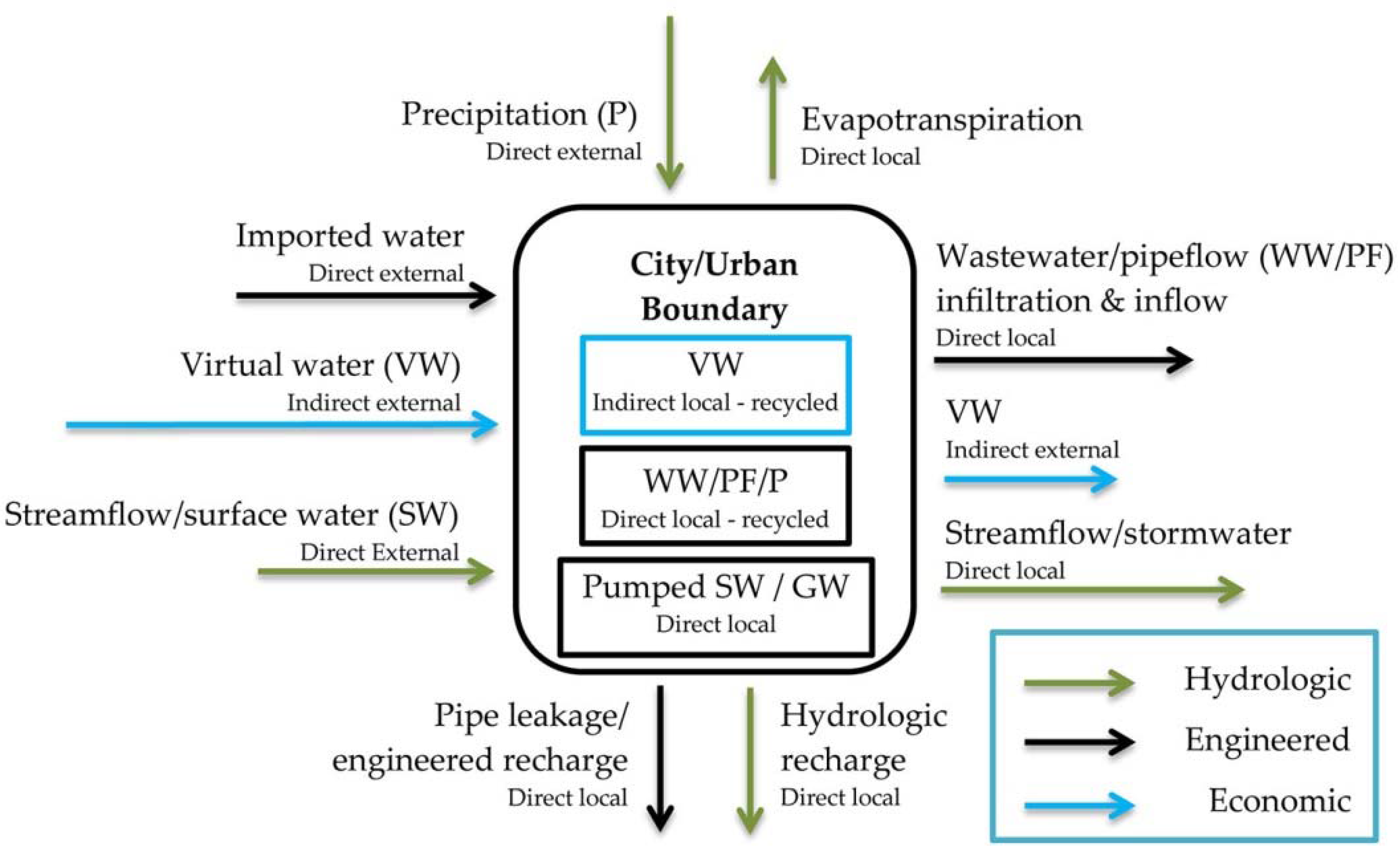
The WF can be viewed solely through a lens of water use in production, which includes the physical direct flows within a region as well as indirect flows through the inputs used in production, or it can be viewed from a consumption perspective that incorporates the water being virtually consumed by a region. The WF evaluates water consumption, the water removed from a watershed, rather than water withdrawals or use, where a large percentage is returned as streamflow or recharge. To account for different water sources and levels of water quality, the WF can be expressed in terms of green, blue, and grey WFs (Table 1) [47,59]. Overall, the emphasis of WF analysis has been on the blue and green water components and only a few studies have considered grey water. Methodologies employed for WF analysis can generally be separated into bottom-up (product level approaches) and top-down (sector level approaches) [60,61]. As a number of reviews have been done on general WF methods (see, e.g., [60,61,62,63]), we highlight three main methodologies which have been used for regional or urban studies: (1) Water Footprint Assessment (WFA) which tends to be employed at the product/commodity level; (2) environmentally extended input–output (EEIO) which uses economic IO tables and thus considers sector level data; and (3) life cycle assessment (LCA) which relies heavily on standardization and databases to estimate the environmental, including water, and health impacts of products along their full life. Hybrid approaches of these methods have also been utilized to integrate scales and available datasets. In Table 2, we outline some of the main advantages and disadvantages of using these methods at the urban scale.
Table 1. Blue, green, and grey water footprints (WFs).
Blue WaterGreen WaterGrey Water
Volume of water sourced from surface water or groundwater/baseflow. Determined by modeling evapotranspiration for irrigated water or a consumptive water coefficient is applied for water withdrawals.Volume of water that is determined by the moisture in the soil-water evapotranspired through plants and soils. Evaluated for agricultural processes.Volume of water necessary to assimilate waste flows. Primarily evaluated for nitrogen and phosphorous content in return flows. Determined by dividing pollutant load by the difference in the maximum acceptable concentration and the natural concentration of the receiving water body.
Table 2. Advantages and disadvantages of WF methods applied at the urban scale.
WF MethodScaleAdvantagesDisadvantages
Water Footprint Assessment (WFA)Product level (bottom-up)WaterStat database. Detailed analysis of agricultural products to give specific estimates of foods grown in certain regions. Dietary WF may be an easier communication tool. Partial supply chain assessment. Takes a systems approach to evaluate sustainability. Evaluates blue, green, and grey water.Primarily uses national or state/province level averages that do not show unique consumption patterns of the city.
Environmentally extended input–output (EEIO)Sector level (top-down)Full supply chain assessment. Can identify hot spot sectors as key water users, assess the water inter-dependency and efficiency of sectors, and identify the “water multiplier” indicating the degree of virtual water recycling between sectors within the city. Can easily compare changes across time using IO tables.Aggregation errors within each sector and disaggregation errors as IO tables are often not created at the urban scale. Primarily considers blue water.
Life cycle assessment (LCA)Product level (bottom-up)Full supply chain assessment. Explicit consideration of human and environmental impacts. Accounts for opportunity costs of water use. Assists businesses in evaluating supply chain water use and impacts.Focus is on individual products. Difficult to account for all products within the city. Rely on databases that might be limited by the regional or product detail that is available. Inventory stage considers blue water.

2.1. Water Footprint Assessment (WFA)

This method was established by the Water Footprint Network (WFN), which provides the commonly used WaterStat database. This method can potentially be applied at any scale as well as for any economic sector and product to determine the consumptive use of freshwater resources. A complete description of this method is provided by Hoekstra et al. [64].
Due to the large share of global freshwater that goes into agricultural production, the interest in considering green water, and the ability to directly incorporate hydrologic modeling outputs, the WFA method has most prevalently been applied to estimate the WF associated with agricultural commodities, including livestock. In the WFA method, global hydrologic models are primarily used to estimate product WFs. Key models that have been used include CROPWAT [38,65,66,67], the Global Crop Water Model (GCWM) [68,69], and the H08 [70,71], among others. Once the virtual water content of agricultural commodities is found, a subsequent step is to determine the destination of this virtual water. Part of this virtual water may be consumed locally while the remainder is transferred to another region. Note that this separation between local and transferred virtual water is strongly dependent on the boundary or scale definition.
To determine where the virtual water is transferred to, two different approaches have been implemented at the subnational scale. Note that throughout we refer to intra national exchanges as “transfers”–those that are explicitly within the national border–and refer to international exchanges as “trade”. We also use “trade” where the delineation is mixed. The first approach models commodity transfers using the assumption of commodity mass balance. For example, Hoff et al. [69], using a regional top-down disaggregation, allocates virtual water from cells (~10 × 10 km2 or 5 arcmin) with a production surplus to cells with a deficit by iteratively redistributing the virtual water to neighboring cells. The cell values prior to redistribution were obtained by downscaling national estimates of consumption and production to the grid level based on gridded population and land area, respectively. This approach requires minimal local or intra-urban data and thus it is most useful for global studies. Since it does not account for the actual food miles traveled by commodities, it could lead to bias estimates for some regions and cities. A similar commodity balance approach was implemented by Ma et al. [66] for provinces in China and by Mubako and Lant [65] for states in the U.S. The second approach uses empirical data on commodity transfers. For example, Dang et al. [72] use Commodity Flow Survey (CFS) freight shipment data for the U.S. to determine virtual water transfers within the U.S. Due to the anomalous consumption characteristics of cities, it would be desirable to use empirical data on commodity transfers to quantify the WF of cities. However, this high resolution data is not available for all countries. As cities are extremely heterogeneous and specialize in a highly biased portion of the hydro-economy (i.e., services and manufacturing), top-down disaggregation approaches that begin at a regional or national scale, and include the agricultural and energy economies, are not likely to yield accurate information about the urban WF unless they are constrained by detailed urban water use and trade/transfer data.
The WFA method has been extended as a basis for Coupled Natural Human System (CNH) network analysis and modeling. This extension has provided opportunities to gain insight into the spatial scaling and process drivers behind transfers, to better understand the dependence among different regions and the importance of different transfer paths (network links), and to identify water savings. Ultimately, network and multi-network approaches provide a mathematical framework for the integrated characterization and modeling of the system (e.g., producers, consumers, transfers, etc.) underlying the WF [35,73]. Additional information and examples of the application of network analysis to WF studies can be found elsewhere [71,73,74,75].

2.2. Environmentally Extended Input–Output (EEIO)

EEIO analysis evaluates the interdependencies between sectors by tracking monetary flows along the supply chain that are then connected with environmental consumption coefficients [76,77]. In the context of WF analysis, this means that EEIO allows the determination of the amount of virtual water, typically in units of a water volume per dollar of commodity value, that is transferred between two process nodes in the trade network. For this, one needs the amount of consumptive water used by each sector in the IO tables. The IO tables quantify the value of the economic transactions between the different sectors.
The IO approach to economic data was introduced by Nobel Prize winner Wassily Leontief. Since its inception, it has become a standard economic tool and is primarily used in assessing employment impact from investments across sectors [78]. EEIO has been implemented at the single-region (SRIO) [79], inter-regional (IRIO) [80,81], and multi-regional (MRIO) [82,83] level. A detailed account of the IO framework and its extensions is given by Miller and Blair [84]. As is the case with WFA, the method does not necessarily imply a given scale of analysis, instead the lack of data has dictated the scope and boundaries for which EEIO is most often employed. When accounting for multiple spatially distinct regions, MRIO analysis is used and transfer or trade data between locations is required. Hence, the trend has been to employ MRIO at the national scale where trade data is more readily available [82,83].

2.3. Life Cycle Assessment (LCA)

LCA evaluates industrial supply chains to account for the full life of a product and the environmental impacts which accrue along its path. LCA has only recently been used to evaluate freshwater use across products and sectors [85,86,87,88,89]. A large emphasis of LCA is in creating, implementing, and maintaining a standard for comparatively assessing the systemic human and environmental impact associated with the creation of products. These standards are outlined by the International Organization for Standardization (ISO). As part of this standardization, they support the development of inventory databases that streamline the assessment process. Some of the commonly used databases are ecoinvent, GaBi, and Quantis. The latter two are tracking freshwater consumptive use whereas ecoinvent currently tracks withdrawals [86,90]. In regards to water resources, LCA research is working towards standardizing the quantification of impacts to water resources, such as distinguishing between withdrawals and consumptive use, and the effect of water degradation [85,91]. In comparison with the LCA, the WFA takes a macro approach for assessing impacts and making overall sustainability recommendations. Additional discussion on the differences in these methodologies are provided elsewhere (see e.g., [62,85,92,93,94,95,96,97]).
LCA can be useful for assessing the WF of individual products and commodities in urban areas. For example, Huang et al. [98] analyzed the consumptive water for tomatoes, maize, and wheat in Beijing and included consumed water for the supply chain inputs of transportation, packing materials, and additional farm inputs. To assess impacts, they applied a water stress index [85] for each crop dependent on the source region and determined water degradation footprints by assessing a grey WF and aquatic eutrophication footprint. However, this analysis is limited in scope to single products. To account for the city scale, each product consumed and produced in the city will need to be analyzed. Thus, LCA is most applicable for assessing the sustainability of individual, alternative products but not the entire urban system which is comprised of many economic sectors and numerous products. Hybrid approaches combining LCA and EEIO are being implemented to address multi-scale issues in urban areas [83,99]. An important step in the more routine implementation of LCA for WF analysis was the release of the ISO 14046 guidelines. In the context of urban areas, where the ability to incorporate and maximize the use of local data is crucial, the strong dependence of LCA on standardized inventory databases may result in an undesirably standardized and under contextualized characterization of water sustainability. This lack of subjective contextualization could be an important limitation for urban water LCA studies that aim to inform a specific municipality’s planning and water supply decision-making process.

3. Water Footprint Studies at Different Spatial Scales

The majority of WF studies have been performed at the national scale [47,75,100,101,102], partly because of the need for national water security, the ability of nations to potentially affect major economic trade patterns, and the availability of bilateral trade data [103,104,105]. However, the number of regional and urban scale studies is steadily increasing. Thus, we review in this section WF studies at the national, subnational (includes single regions and interstate transfers within a country), and urban scale.

3.1. National Scale

Allan [39] first introduced the concept of embedded water to address food scarcity concerns for arid regions. He asserted that arid countries with low incomes face issues of food scarcity whereas wealthy countries have access to international trade markets and can import water rich products. Indeed, the national scale studies have shown the ability of virtual water flows to transport water indirectly to water scarce regions and also that wealthier countries are typically net virtual water importers even without having issues of scarcity [47].
The first global virtual water estimates evaluating international crop trade were determined by Hoekstra and Hung [38], and the WFN (http://www.waterfootprint.org) publishes independent reports, in addition to the UNESCO-IHE report series, which provide updated national and global WFs. The global WFs are obtained by aggregating the national estimates. Hoekstra and Mekonnen [47] analyzed the blue, green, and grey WF of humanity and showed the variability of national WF by evaluating trends in both production and consumption footprints. They found that one fifth of the WF of global production was for exported goods, thereby highlighting the global role played by virtual water flows. Konar et al. [75] used network statistics to evaluate international virtual water trade, highlighting that nations which export large volumes of water are also more likely to trade with other large water exporters. Dalin et al. [106] evaluated the temporal evolution of the network statistics of global virtual water trade, showing that countries not only increased their trade partners but increased, to a greater extent, their virtual water trade and savings. For example, they found that the volume of water tied to trade more than doubled over a 22 year period from 1986 to 2007. Tamea et al. [107] found that population, gross domestic product (GDP), and distance between trade nations are all correlated with the amount of imported virtual water. In addition, their results indicated that domestic water resources are not strongly correlated with international virtual water flows, instead economic factors are the main driving force. Using a MRIO approach, Lenzen et al. [108] determined the virtual water trade among 187 nations. To account for water scarcity, Lenzen et al. [108] first weighted the blue water use according to a national water stress index. This study showed that some water rich countries import from water scarce countries. Many other studies have been conducted at the national scale (see e.g., [101,109,110,111,112,113,114]), we have covered only a few to underscore key findings.
Overall, national scale findings highlight that global economic forces impact water resource use. Cities play a central role in globalization since they are key drivers of economic activity through their production processes and their concentrated use of food, energy, and manufactured goods [115,116,117]. To account for this, WF analysis at the urban scale is required. To support water resources management, the city and intra-urban scales are ideal given the range of direct (e.g., water supply, water quality, water reuse, flood control, etc.) and indirect (e.g., consumption of goods and services) water decisions that are made by cities and their citizens.

3.2. Subnational Scale

The studies that have estimated the WF and virtual water flows at the subnational scale are summarized in Table 3. Among the subnational studies, Dang et al. [72] quantified the WF of food flows within the U.S., building upon earlier work by Lin et al. [118]. Lin et al. [118] employed network analysis, together with CFS freight shipment data for the U.S., to examine food flows within the U.S. The study by Dang et al. [72] provides insight into how the WF of trade varies across scales, by directly comparing the volume of the WF of domestic food transfers with the total volume of water embodied in international food trade. They found that the WF of food transfers within the U.S. is equivalent to 51% of international trade, which is slightly higher than the corresponding food value and mass shares, due to the fact that water-intensive meat commodities comprise a much larger fraction of food transfers within the U.S.
A number of case studies at the subnational scale have identified that water rich regions import from water scarce regions [66,80,119,120]. This can be likened to the Leontief paradox, which opposes the notion of trade being determined by comparative advantage, and showed that the U.S., a capital-intensive market, actually imported capital goods and exported labor-intensive goods. For example, Yu et al.’s [119] study of the United Kingdom (UK) found that the relatively dry southeast utilizes more water in agriculture than the water rich northeast. Guan and Hubacek’s [80] and Ma et al.’s [66] studies showed a greater amount of virtual water transfers from the water scarce north China to the water rich south China. This was also found in Verma et al.’s [120] study where arid eastern India was exporting goods to the wetter western India. The presence of this paradox can be explained further by considering other elements that can crucially influence interstate transfers and international trade such as climate, land use conditions, and socioeconomic differences among regions. For instance, the climate for year round growing is beneficial for water scarce northern China [80]. Also, south China has seen a shift from a mostly agricultural society to a now industrial society which has created land use changes that have diminished the potential for food production there [66]. While in eastern India farmers are heavily subsidized in comparison to the western region [120].
The subnational case studies, when contrasted with the national studies, support the need for performing WF analysis using different boundaries, as the behavior of virtual water flows and the interpretation of the WF changes with the boundary. For example, the transfer of virtual water from water scarce to water rich regions is most evident at the subnational scale. It remains to be clarified how cities contribute to this trend.

3.3. Urban Scale

The urban WF studies have been performed for Beijing, China [66,97,121,122,123]; Milan [124]; London, UK [125]; as well as Berlin, Delhi, and Lagos in Germany, India, and Nigeria, respectively [69]. Hoff et al. [69] found that Berlin imported more than 60% of its virtual water from abroad whereas the virtual water for the developing cities of Delhi and Lagos primarily came from domestic sources. There were also high variations in the cities virtual water import per capita with the total virtual water import of Delhi (~434 m3/year) being lower than that of Berlin (~643 m3/year). This was attributed to diet choices. For example, the high water-intensive meat (evaluated in the form of livestock feed) and coffee consumption of Berlin results in higher virtual water flows there. Lagos, however, had almost double the virtual water import of Berlin with 1210 m3/year per capita, which was attributed to their consumption of millet, sorghum, and cassava, as well as their low crop water production. Ultimately, Hoff et al. [69] conclude that evaluating the WF and virtual water flows at the regional and city scale provides insight into water consumption that is lacking at the national level.
As shown in Table 3, the majority of the urban studies have employed approaches that rely on input–output (IO) tables and most are for a single city, Beijing, which is heavily water stressed [126]. For instance, Wang et al. [123] compared the WF of Beijing for the years 2002 and 2007 using sector level data. They found that over this period there was a decline in industrial and agricultural water use and that the city was a virtual water importer. In addition, using grey water estimates, they indicated that water shortages are a bigger concern in Beijing than water pollution. Zhang et al. [122] assessed the blue WF for Beijing for 2002 and found that 51% of Beijing’s WF was from virtual water imports. Overall, results from the Beijing studies in Table 3 indicate that virtual water flows are an important source of water stress alleviation for this city; however, products are often sourced from water strained regions in northern China [127]. Thus, understanding the dynamics of virtual flows, together with the consideration of different boundaries, has important implications for urban and regional water management in the case of Beijing.
One of the main conclusions from urban scale studies is that there can be large differences between national and urban scale estimates of WF. For example, Feng et al. [125] found that the consumption WF per person for London, UK, was 58% higher for direct water use and 79% higher for virtual water use than the national average. Feng et al. [128] also found this for urban household’s in the Yellow River basin identifying a 50% higher WF than rural households. Ultimately, to account for the heterogeneity and unique characteristics of each city (e.g., size, population, infrastructure, diet, industries, income distribution, quality of life, etc.), WF analysis at this scale needs to incorporate local (city and finer scale) data. This is one of the key challenges for urban WF analysis which we discuss further in Section 4.
The urban studies in Table 3 incorporate local assumptions and data in different ways. For instance, together with assumptions for the local redistribution of production surpluses and deficits, Hoff et al. [69] downscaled national WF estimates based on gridded population, while Feng et al. [125] combined national (e.g., IO tables) and local (e.g., income, demographic, and consumption estimates) data when determining the WF at the local authority level in the UK. The need to relate and employ datasets from different scales (e.g., national, subnational, and local) in urban WF studies can be an important source of WF variability and uncertainty that needs to be further understood and quantified. In a regional context, this was also stressed by Fulton et al. [129] as part of their WF analysis for California and by Zhuo et al. [130] in their case study for the Yellow River basin, China.
Table 3. Summary of studies that have evaluated the WF at the subnational and urban scale.
*City/RegionStudy byWater FootprintMethodology **
CBerlin, Delhi, and LagosHoff et al., 2013 [69]Green and blue WFA
CMilan, ItalyVanham, 2014 [124]Green, blue, greyWFA
RCaliforniaFulton et al., 2014 [129]Green, blue, greyWFA
BHeihe River basin, ChinaZeng et al., 2012 [131]Green and blue WFA
BYellow River basin, ChinaZhuo et al., 2014 [130]Green and blueWFA
BEuropean River basinsVanham, 2013 [132]Net virtual waterWFA
SInterstate transfers in the U.S.Mubako and Lant, 2013 [65]Green and blueWFA
SInterstate transfers in the U.S.Dang et al., 2015 [72]Green and blueWFA
SInterstate transfers in IndiaVerma et al., 2009 [120]Green and blueWFA
SNorth and south ChinaMa et al., 2006 [66]Green and blue (surface and groundwater)WFA
SInterprovincial transfers in ChinaDalin et al., 2014 [71]Green and blueWFA
SInterprovincial transfers in IndonesiaBulsink et al., 2010 [133]Green, blue, greyWFA
SWestern U.S. statesRuddell et al., 2014 [73]BlueWFA/MRIO/ERA
CBeijing and ChinaHubacek et al., 2009 [134]BlueSRIO
CBeijingWang and Wang, 2009 [121]BlueSRIO
CBeijingZhang et al., 2011 [122]BlueMRIO
CBeijingWang et al., 2013 [123]Blue and greySRIO
BHaihe River basin, ChinaWhite et al., 2015 [135]Blue MRIO
BHaihe River basin, ChinaZhi et al., 2014 [136]BlueSRIO
BHaihe River basin, ChinaZhao et al., 2010 [137]BlueSRIO
BYellow River basin, ChinaFeng et al., 2012 [128]Green and blue (rural/urban WF)MRIO
SLiaoning Province, ChinaDong et al., 2013 [138]BlueSRIO
SShandan County ChinaDeng et al., 2014 [139]BlueSRIO
SNorth and south ChinaGuan and Hubacek, 2007 [80]Blue (considers wastewater) IRIO
SInterprovincial trade in ChinaFeng et al., 2014 [127]Blue MRIO
SInterprovincial trade in ChinaJiang et al., 2014 [126]BlueMRIO
SThe southeast and northeast UKYu et al., 2010 [119]Green and blueMRIO
SDomestic UKFeng et al., 2011 [125]Green and blueMRIO
CSydney and Melbourne, AustraliaLenzen and Peters, 2010 [140]Indirect impacts of blue water useMRIO
SVictoria, AustraliaLenzen, 2009 [82]BlueMRIO
SAndalusia, SpainVelázquez, 2006 [80]BlueSRIO
SCalifornia and IllinoisMubako et al., 2013 [82]Green and blue (also saline water)IRIO
CBeijingHuang et al., 2014 [98]Blue and grey LCA
Study evaluates scarcity; * C–City, B–Basin, and S–Subnational; ** Water Footprint Assessment (WFA), Life Cycle Assessment (LCA), Embedded Resource Accounting (ERA); Input–Output (IO), Single-Region (SRIO), Inter-Regional (IRIO), and Multi-Regional (MRIO).

4. Discussion

In this section key themes and limitations are identified that we see as helpful for guiding and motivating future research in urban WF analysis.

4.1. A General Approach for Urban Water Footprint Analysis

Previously, in Section 2, we reviewed the advantages and drawbacks of the three main methods that have been implemented for WF analysis at the regional and urban scale. On the basis of that review, we find that WFA and EEIO are useful for urban WF analysis. The application of LCA is limited by its emphasis on individual products. Ultimately, the selection of a given method will depend on the scope of the study, the available datasets, and other preferences. We also indicated cases in which the strengths of these methods have been combined (see e.g., [34,36,83]). As new datasets are collected and developed for urban areas, the ability to combine these methods will increase. To do this effectively and consistently, it is desirable to have an overarching framework that clearly articulates the connections among the urban water flows and WF methods.
Urban WF studies have not clearly distinguished all of the different urban water flows, leaving out flows such as stormwater. In Figure 1, we identify the different direct and indirect urban water flows and further categorize them as local or external if they originate from within or outside the urban boundary, respectively. In this figure, direct water supplies are transferred into the urban boundary from external (imported water; e.g., water from a supply reservoir outside of the urban boundary) and internal (pumped surface/ground water; e.g., ground water withdrawn from within the urban boundary) sources. This transferred water either exits the boundary as wastewater, pipe leakage, or infiltration and inflow, or it remains within the boundary as recycled water. These direct flows are of primary concern to the city water manager and tracking direct flows within the boundary is an important consideration for the urban WF. The virtual water is imported through the consumption of goods and services and exported by producing goods and services that are consumed outside of the urban boundary. In relation to stormwater, assuming that this is separate from the sewer system, the natural water balance components are all relevant such as precipitation, evapotranspiration, streamflow, and recharge. The way to include stormwater effects in urban WF analysis needs to be further investigated; it likely involves the net impact on internal and external surface and ground water stocks resulting from urban land development and hydrologic alterations. In the case of imported water and pumped surface water, a consumptive coefficient is applicable but this does not apply to stormwater. Assessing a grey water volume for the amount of water needed to assimilate these flows may be appropriate. For instance, when looking at wastewater in Milan, Vanham and Bidiglio [124] assumed that the grey WF could be set to zero as wastewater is treated. Further investigation of grey water analysis in urban regions is needed and a complete urban WF analysis will need to consider all the flows identified in Figure 1.
Figure 1. Conceptual diagram of the direct and indirect water flows of an urban area. The recycling of direct and indirect local water within the urban boundary is also identified. Flows are defined as local and external if they originate from within or outside the urban boundary, respectively. Flows are also identified as hydrologic, engineered, and economic.
Sustainability 07 08461 g001
Recently, a generalization of EEIO and EFA methods, termed Embedded Resource Accounting (ERA), was proposed and developed [35,73,141]. ERA makes explicit the assumptions implied by the different footprint standards and methods, and in doing so it not only adds transparency to footprint analysis but it also facilitates the integration of different datasets (e.g., IO tables, commodity flows, etc.). For example, ERA uses the notion of equivalency to clarify that typically, in WF analysis, the same volume of water in two different countries is treated as being the same or having similar value, whereas in reality the local context will modify the value of water. The rich conceptual scheme of ERA [35,73], which borrows ideas, tools, and terms from systems, network, economic and sustainability science, among others, allows the consideration of point of view (POV). The POV may represent the person or business doing the accounting, a given standard, a management priority, etc., each with its own boundary definition. POV captures the fact that different water users will subjectively alter the boundaries of the system, selectively including or excluding some water impacts, for the purpose of their WF analysis and decision-making. Ultimately, this affects the accounting of direct and indirect water and has implications for the attribution of water impacts. The attribution of impacts is strongly dependent on the legal and political context and the social objectives of the decision-makers. ERA was recently applied to the case of water embedded in the electrical energy trade in the western U.S. [73], demonstrating how water use in one location may be discounted compared with water use in another location.
The consideration of POV is useful for urban WF analysis. Urban areas have many different water stakeholders (e.g., urban residents, utilities, businesses, city officials, environmental groups, etc.), each with its own POV. Indeed, ERA has many of the key characteristics required for a complete method for urban WF analysis. Generally, we suggest that a complete method for urban WF analysis should have the following key characteristics: (1) ability to resolve and distinguish, comprehensively and from the top-down, all the specific connections with all the producers and consumers both outside and inside the urban boundary; (2) distinguish socio-hydrologically non-risky and sustainable from risky and non-sustainable connections by identifying hotspots along the supply chain; (3) explicitly relate and distinguish the different connections (flows) indicated in Figure 1, including the recycling of virtual water into distinct and qualitatively different water stocks within the urban boundary; (4) relate and benchmark WFs of processes with respect to the values produced within and outside the urban area; (5) explicitly consider boundaries and POV; and (6) provide synthetic and meaningful information to urban citizens as well as urban stakeholders and decision-makers.

4.2. Spatial Scale or Boundary for Urban Water Footprint Analysis

Identifying the boundaries of an urban area can be challenging [142,143]. This is mainly because urban areas tend to be strongly connected to their neighboring urban areas, rural hinterlands, and distant areas for their economic and hydrological functions. Also, the spatial extent of urban areas changes in time, cities can grow or shrink, independently of their defined administrative and political boundaries [144] and potable water supply zone. The changing form of urban areas and their connectivity with other distant areas makes any definition of hydro-economic decision boundaries relative to context. Hence, the dynamics and flows of virtual and real water in an urban area will crucially depend on the definition of the boundary. It thus seems necessary to simultaneously compute WFs at multiple boundary conditions when dealing with flows in urban areas, for example the potable water supply boundary, the watershed or aquifer boundary, the state or regional government boundary, national boundary, and planetary boundary.
In practice, for research purposes, the definition of the urban scale tends to be arbitrarily set by the dataset employed and the agency in charge of data collection. For instance, in the U.S., the Census Bureau uses several definitions of urban areas: metropolitan statistical area (MSA), microstatistical area, and combined statistical area (CSA). The MSA has a rural to urban gradient as it consists of one or more counties around an urban core that has a population greater than 50,000 while the microstatistical area is a densely populated region with more than 10,000 residents but less than 50,000 [145]. The CSA is a grouping of adjacent MSAs. Furthermore, river basins, population, and population density have all been used to define boundaries for urban areas [17,56,132]. There are multiple definitions of an urban area and this should be taken into consideration in urban WF analysis, because per the logic of ERA these different boundaries imply different points of view and different accounting of footprints and values.
Bringing the urban WF to the parcel/individual establishment and residential level will create the most opportunity for urban citizens, stakeholder groups, and water managers to operationalize the urban WF metric, and it will provide the most reliable information for informing urban planning and policy decisions. Detailed urban WF studies (i.e., at the parcel/individual establishment level) could help account for the spatial variability of WF components within each city and their unique interaction with the different direct and indirect water supplies, and help assess the implications of local urban impacts on the WF. However, economic data collection is generally not harmonized with the boundaries of an urban potable water provider—a limitation that should be addressed by the economic development and planning departments of cities that wish to employ WF analysis. More research into the effects of boundaries on urban WFs, sustainability benchmarks, and water decisions is needed. Specifically, economic statistics need to be developed by city governments for industrial and commercial (IC) establishments within their boundaries, and these statistics need to be linked with water consumption accounts and urban land use planning data. This three-way linkage between IC socio-economic productivity, IC water use, and land use planning will provide the foundation for urban water planning and decision-making utilizing WFs.

4.3. Required Datasets for Urban Water Footprint Analysis

We describe here the required and available datasets for urban WF analysis from parcel to city scale with a focus on the U.S.; however, many of these constraints are found for all cities. Within an urban area, the primary focus of WF studies has been on commodity transfers and transfers among economic sectors (see Table 3). Recent work has identified a second distinct WF, associated with labor (commuting flows) [141]. The WF associated with interstate transfers and international trade emphasizes industrial and commercial linkages and dependencies between geographic areas that may be disrupted by or vulnerable to water shortages and scarcity, while the WF associated with the movement of labor emphasizes the interdependency between economic production, environmental quality, and shared critical infrastructure. These commuting flows, may not be the dominant water users at the national scale, but provide insight into the movement of water near to and within the urban boundary.
Water withdrawal data necessary to systematically calculate the WF of multiple urban areas exist, but the data varies by quality and validity [146]. Harmonizing datasets poses the largest challenge to creating a system to calculate the WF of trade for each city in a country. Table 4 summarizes available datasets for urban WF analysis in the U.S. The agricultural census provides relevant data about agricultural products and land under crop production, but the scales at which data are available also pose disaggregation challenges. In the U.S., farm census data is available at the zip code level (USDA Census of Agriculture in Table 4) and is associated with a city name, but not necessarily located within the city, which creates a positive bias in WFs; associating too many water consuming activities to the city.
To determine virtual water flows, for many commodity flow and trade databases (e.g., CFS, FAF3, and FAOSTAT in Table 4), the finest-scale geography for trade data is the metropolitan area and reliable methods need to be developed to disaggregate trade data to the city-scale [147,148,149,150,151,152]. Employment and establishment counts collected at the city level and located in national census (e.g., U.S. Census and CES in Table 4) provide one method of disaggregation, but readily available public data may be unreliable due to data omissions to protect the identity of businesses that may be singled out in census data. Trade databases contain agricultural and mineral commodity flows, but commodity flows may not sync with where the actual production of commodities occur, requiring validation of commodity flow data.
To determine the direct water component, utility-level data of IC consumption and residential (domestic) consumption [153] provide directly observed water consumption data, but the frequency and validity of water consumption reporting by water utility varies by utility [146]. Data challenges for some commercial water uses (e.g., economic activities that create industrial production and water used for power plant cooling) include a data disaggregation step to separate commercial activities from domestic water consumption as most commercial activities are supplied by water utilities. IC data from water utilities is often publically-available, but only for broad water use categories and has not been tied to commodity codes or industrial classification systems such as the North American Industry Classification System (NAICS), Standard Classification of Transported Goods (SCTG), Standard Industrial Classification (SIC) System, and Harmonized System (HS).
Harmonizing IC water utility account-level data with industrial classification systems is possible, but burdensome for large water utilities. Further, IC accounts may have multiple meters that provide water for business activities that produce different commodity classes as well as support service-sector activities, making it difficult to associate trade, value, and consumption to specific commodity types, and vice versa. Recent progress in addressing this issue can be found in [154]. The major data hurdles facing the systematic calculation of urban WFs of labor are extant commuting data and domestic water use data. In the U.S., the USGS water withdrawal data (Table 4) provides county-level specificity of domestic water uses, but this may not provide the relevant detail for most cities. Further work is required to create a system that matches account-level attributes (industrial, commercial, and residential) to commuting flows and economic production and the aforementioned industrial classification systems. This process will allow for the attribution of an urban area’s WF down to the parcel level, similar to advances with carbon emissions and carbon footprints [155,156,157]. The systematic calculation of urban WFs of trade and labor are constrained by the extant datasets. Due to this, there will be a lag between current water management needs and the urban WF calculations. Given the timeliness of trade and water data publication, urban WFs can be calculated systematically at the decadal, and possibly quinquennial, time scale (see, e.g., the datasets in Table 4). Limitations in linking water consumption data to industrial classification will limit the detail of WFs to the economic sector (NAICS, SCTG) and economic megasectors [158,159]. However, this level of detail will still allow for the identification and management of long-tail sources and exporters of virtual water that are the critical linkages in the virtual water trade network.
Table 4. Identified datasets for urban WF analysis in the U.S.
SourceType of DataSpatial ScaleTemporal Scale (Most Recent)
Bureau of Labor StatisticsConsumer Expenditure Survey (CES)-Complete information on consumers’ expenditures and incomes-Section 20A collects expense estimates for food and beverages per household.National, regional, state, and MSAQuarterly and yearly (2013)
Bureau of Economic Analysis (BEA)National input–output datasets. Also provides regional input–output modeling system (RIMS) multipliers, GDP analysis, and details on imports and exports at national level.NationalEvery 5 years (2007–years with 2 and 7)
IMPLANEconomic databases and methodologies to construct input–output tables. National, state, county, MSA, and zip codeYearly
US CensusPopulation and socioeconomic statistics, including employment, income, and GDP.National, state, county, MSA, city, and townEvery 10 years (2010)
US Census Agricultural Imports and ExportsAgricultural exports and imports. Volume by principal commodities and by value. Also provides consumer expenditures for farm foods.NationalYearly (2010)
USDA Census of AgricultureFarm and Ranch Irrigation Survey for blue water calculations. Harvested cropland by size of farm and acres harvested. Inventory and sales of livestock.State, county, and zip codeEvery 5 years (2012)
Bureau of Transportation Statistics-Commodity Flow Survey (CFS)Primary source on domestic freight shipments by American establishments in 42 sectors. Provides a modal picture of national freight flows, and represents the only publicly available source of commodity flow data for the highway mode. Used to track commodity to source region.National, state, and MSAEvery 5 years (bilateral only in 2007, 2012)
Federal Highway Administration and Bureau of Transportation Statistics- FAF3Integrates data from the most recent CFS and a variety of sources to create a more comprehensive picture of freight movement among states and major metropolitan areas. Provides estimates for tonnage, value, and domestic ton-miles by region of origin and destination, commodity type, and mode.National, state, and MSAEvery 5 years. Last finalized data were 2007, interim data for 2012 and projected to 2040
USGSWater withdrawal data for 8 sectors: public supply, domestic, irrigation, livestock, aquaculture, industrial, thermo-electric-power generation, and mining.National, state, and countyEvery 5 years (2010)
USGS MRDSMineral resources data for production of all minerals, including sand and gravel, and locations of mining operations worldwide.GPS coordinates of each mining site in the world(2011)
FAOSTATFood and agricultural commodity production data for every country. Food balance sheets created to determine a country’s food supply.NationalYearly (2012)

4.4. Urban Metabolism and Water Footprint Analysis

Urban metabolism (UM) is generally concerned with the quantification of material flows (e.g., water, energy, nutrients, etc.) through an urban boundary, including waste-related flows [24,160]. The aim of UM is often to identify and characterize trends and patterns in these material flows to formulate and design more efficient urban systems as well as to better integrate social and environmental concerns into urban planning [161]. UM was brought into popularity by Wolman [162], an educator and water resources and sanitary engineer. Wolman [162] described and quantified the inputs and outputs (e.g., supply of water, disposal of sewage, and the amount of air pollution) associated with a hypothetical U.S. city of 1 million inhabitants. The flow accounting procedure for UM, most applicable to WF accounting, is material flow analysis (MFA) which has been coupled with methods discussed in Section 3 and with footprint standards, e.g., LCA [163], EEIO [164], and EF [8]. Specifications and tools for conducting MFA are available (see e.g., [30]) and Zhang [165] provides a comprehensive review of UM studies and approaches.
For urban WF analysis, the data and results from existing and future UM studies could provide support for urban WF studies, as direct water use is commonly tracked in UM. UM in its historical usage is explicitly not a “virtual” or LCA analysis, and deals with physical flows. An important and omnipresent hindrance to UM studies, including expanding their scope, is the limitations in data availability [8,24,90,165]. For instance, Kennedy et al. [166] compared eight different UM studies to identify trends across time and found limitations due to the different types of data and approaches used. The need to develop a common framework for UM studies has been indicated before [167] and is a shared challenge of UM and urban WF analysis that could provide additional research opportunities.
In terms of sheer mass and cost of delivery, water is typically the largest flow through the urban boundary out of the various flows in UM studies [161,166]. Water flow in the UM framework has primarily been tracked in terms of direct use and waste flows passing the urban boundary [161,166]. Huang et al. [161] indicate that an urban water metabolism efficiency indicator system is needed and should be extended to account for both virtual and physical water flows. They suggest the need to incorporate the so-called ‘social water cycle’ that is relevant within the urban boundary. This notion consistently emerges out of urban sustainability studies, i.e., the need to integrate human and biophysical systems [73,160,168,169]. We suggest that a way of achieving and quantifying this integration is through WF analysis that includes but distinguishes direct and indirect WFs, incorporating both UM and virtual flows. WF analysis provides a synthetic measure of both the water being used, which ultimately depends on its natural cycling, as well as the human activity driving this water use, directly and virtually (see Figure 1).

4.5. Applications of Urban Water Footprint Analysis

Cities are actively and innovatively implementing green infrastructure, water reuse techniques, and other technologies to ameliorate direct impacts on water resources [170,171,172]. For example, the city of Philadelphia in the U.S., as part of its green city initiative [173], has identified as a key target the need to protect and restore the quality of its urban basins and rivers. Other areas, such as Las Vegas or Maricopa County in the U.S. southwest, have implemented extensive water recycling and water conservation measures along with zero-runoff stormwater and recharge programs. Similar initiatives for restoring the quality of local waters and improving urban water services are underway in several other U.S. cities and in cities across the globe [174,175].
Targets require metrics, which are water use sustainability and productivity benchmarks. The development and adoption of appropriate metrics and benchmarks will be the key to advancing city and business decision-making and planning in the area of water sustainability. For instance, Van Leeuwen and Sjerps [174] developed and employed an urban water index comprised of measures covering a range of water-related categories such as water security, water quality, drinking water, sanitation, infrastructure, climate robustness, biodiversity and attractiveness, and governance. They applied this index to 30 cities covering 22 different, mainly European, countries. Within the broader context of urban sustainability, the United Nations started the Global Urban Indicators Database (http://ww2.unhabitat.org/programmes/guo/guo_indicators.asp) in 1993, which includes data from over 237 cities, to track the livability of the participating cities using measures of wastewater treatment, air pollution, waste disposal methods, disaster management, and environmental planning. The World Bank developed the Eco2 Cities Guide to help city planners build comprehensive sustainability plans within a participatory process [176]. As part of this plan, they propose using different water-related indicators derived from MFA. Siemens [177] developed a green city index to measure the environmental performance of 27 cities in the U.S. and Canada. This index is comprised of several water indicators such as the per capita water use, water system leakages, stormwater policy, and water quality.
What is missing from all of the initiatives and studies just described is the explicit consideration of the water impacts that cities can create outside their boundaries through commodity exchanges, as well as the vulnerability of cities to non-local resource shocks and scarcity. We think that research is urgently needed to expand these sustainability indicators to account for non-local links. It is also critical, per economic theory, to incorporate the production of value into the water benchmarks, because it is equally important to use water beneficially as it is to conserve water; our objective is the creation of value to maximize social welfare, which may or may not lead to the conservation of water. This is an area where we believe WF analysis can lead to tangible and measurable applications as these kind of metrics are often employed to inform high-level investment and management decisions, develop environmentally-sensitive plans, and inform the public [35,178]. In particular, WF analysis could be employed to develop different value intensity metrics [73,178]. Value intensities are particularly useful for urban areas since they can consider multiple values held by multiple stakeholders and they can account for the direct and/or indirect components of the urban WF. Additional definitions and information about value intensities is provided by Ruddell et al. [73].
Applied research for urban WF analysis could also be focused into designing, implementing, and testing ways in which a city may effectively incorporate WF-based metrics into its operational activities and decisions. Indeed, the Urban Water Footprint project in the EU (http://www.urban-wftp.eu/en/) is a recent initiative that will monitor and measure the WF at different spatial scales (e.g., city, neighborhood, and building) in the cities of Vicenza (Italy), Innsbruck (Austria), and Wroclaw (Poland). As part of its goals, the project seeks to implement WF analysis as a tool to improve and assist with urban water management as well as to assess and predict the influence of local policy on urban water. This is an emerging area of application for WF analysis. Beyond any specific research outcomes, this kind of project offers an opportunity to engage city stakeholders and urban citizens, and directly measure the societal value of research outcomes. This can be made possible not only by the research being conducted in cities but also by the ability of the urban WF concept to integrate diverse water-related information.
Other potential applications of urban WF analysis are: increasing recycling of virtual water within city boundaries, which is an indirect effect of recycling more products, i.e., reuse within the city; value-based benchmarking to identify the most and least water-productive direct water uses; and identifying the most and least sustainable virtual connections to manage, incentivize, and/or regulate them to improve the resiliency of a city’s water supplies. Additionally, Badruzzaman et al. [179] outline several WF applications specifically for water utilities. Some of the applications that they highlight are: assessing operational/supply chain water use, assessing water-related regulatory and business risks, selecting between future development options, and identifying unsustainable WFs in the supply chain. Additional and more specific applications of WF to water utilities can be found in their report [179].
Ultimately, the autonomy of cities, their capacity for self-organization and self-initiative, as well as their ability to take action is what makes WF analysis at the city scale appealing and potentially meaningful to an action-oriented audience.

5. Summary

The WF provides a conceptual framework that captures both direct and indirect uses of water. The city scale represents an important future research direction for WF analyses given the dominant economic roles that cities play. Cities are hubs for cultural exchange and through planning and permitting have the unique ability to make impactful local decisions with far-reaching consequences for non-local water resources. By utilizing a consistent approach to identify water fluxes–both real and virtual–for cities, the WF creates opportunities for benchmarks and cross comparisons. This paper has highlighted the benefits and tradeoffs of existing WF methodologies for urban applications. Future work should explore opportunities to use the WF concept to assist decision-makers as we move into a new era of understanding the role of cities in the context of water scarcity.

Acknowledgments

The authors affiliated with the Pennsylvania State University gratefully acknowledge the funding support provided by its Department of Civil and Environmental Engineering. Benjamin L. Ruddell acknowledges the support of the Great Lakes Protection Fund via grant #946, and helpful collaboration with Doug Toy of the City of Chandler, Arizona, USA and the water department staff of the City of Flagstaff, Arizona, USA, and the Central Arizona Phoenix Long Term Ecological Research observatory (CAP-LTER 3, BCS-1026865). Jorge Gironás acknowledges the support from CEDEUS-Conicyt/Fondap/15110020. The present work is a collaboration of the Water Footprint of Cities, an active working group of the Panta Rhei Research Initiative. This work contributes to the Panta Rhei Research Initiative of the International Association of Hydrological Sciences and to the National Water Economy Project. The conclusions and opinions are those of the authors, and not the acknowledged parties or funding agencies.

Author Contributions

Willa Paterson led the collaborative efforts to produce this publication. All authors contributed substantially to the ideas, concepts, and work presented in this paper. All authors were also involved in the preparation of the manuscript and have read and approved the submitted form.

Conflicts of Interest

The authors declare no conflict of interest.

References

  1. Van Vliet, W. Cities in a globalizing world: From engines of growth to agents of change. Environ. Urban. 2002, 14, 31–40. [Google Scholar] [CrossRef]
  2. Dobbs, R.; Smit, S.; Remes, J.; Manyika, J.; Roxburgh, C.; Restrepo, A. Urban World: Mapping the Economic Power of Cities; McKinsey Global Institute: Washington, DC, USA, 2011. [Google Scholar]
  3. Dobbs, R.; Remes, J.; Manyika, J.; Roxburgh, C.; Smit, S.; Schaer, F. Urban World: Cities and the Rise of the Consuming Class; McKinsey Global Institute: Washington, DC, USA, 2012. [Google Scholar]
  4. United Nations (UN). World Urbanization Prospects: The 2014 Revision; Department of Economic and Social Affairs, Population Division; UN: New York, NY, USA, 2014. [Google Scholar]
  5. Léautier, F. Cities in a Globalizing World: Governance, Performance, and Sustainability; World Bank: Washington, DC, USA, 2006. [Google Scholar]
  6. United Nations Centre for Human Settlements (Habitat) (UNCHS). Cities in a Globalizing World, Global Report on Human Settlements; UNCHS: London, UK; Sterling, VA, USA, 2001. [Google Scholar]
  7. Savenije, H.H.G.; Hoekstra, A.Y.; van der Zaag, P. Evolving water science in the anthropocene. Hydrol. Earth Syst. Sci. 2014, 18, 319–332. [Google Scholar] [CrossRef]
  8. Moore, J.; Kissinger, M.; Rees, W.E. An urban metabolism and ecological footprint assessment of Metro Vancouver. J. Environ. Manag. 2013, 124, 51–61. [Google Scholar] [CrossRef] [PubMed]
  9. Averyt, K.; Meldrum, J.; Caldwell, P.; Sun, G.; McNulty, S.; Huber-Lee, A.; Madden, N. Sectoral contributions to surface water stress in the coterminous United States. Environ. Res. Lett. 2013, 8, 035046. [Google Scholar] [CrossRef]
  10. McDonald, R.I.; Weber, K.; Padowski, J.; Flörke, M.; Schneider, C.; Green, P.A.; Gleeson, T.; Eckman, S.; Lehner, B.; Balk, D.; et al. Water on an urban planet: Urbanization and the reach of urban water infrastructure. Glob. Environ. Change 2014, 27, 96–105. [Google Scholar] [CrossRef]
  11. Charles, M. The poor condition of the U.S. Infrastructure. Eng. Med. Biol. Mag. IEEE 2008, 27, 70–71. [Google Scholar] [CrossRef] [PubMed]
  12. Hijdra, A.; Arts, J.; Woltjer, J. Do we need to rethink our waterways? Values of ageing waterways in current and future society. Water Resour. Manag. 2014, 28, 2599–2613. [Google Scholar] [CrossRef]
  13. Wu, W.; Gao, J. Enhancing the reliability and security of urban water infrastructures through intelligent monitoring, assessment, and optimization. In Intelligent Infrastructures; Negenborn, R.R., Lukszo, Z., Hellendoorn, H., Eds.; Springer-Verlag Berlin: Berlin, Germany, 2010; Volume 42, pp. 487–516. [Google Scholar]
  14. Rahm, B.G.; Vedachalam, S.; Shen, J.; Woodbury, P.B.; Riha, S.J. A watershed-scale goals approach to assessing and funding wastewater infrastructure. J. Environ. Manag. 2013, 129, 124–133. [Google Scholar] [CrossRef] [PubMed]
  15. Zhao, L.; Lee, X.; Smith, R.B.; Oleson, K. Strong contributions of local background climate to urban heat islands. Nature 2014, 511, 216–219. [Google Scholar] [CrossRef] [PubMed]
  16. Georgescu, M.; Morefield, P.E.; Bierwagen, B.G.; Weaver, C.P. Urban adaptation can roll back warming of emerging megapolitan regions. Proc. Natl. Acad. Sci. USA 2014, 111, 2909–2914. [Google Scholar] [CrossRef] [PubMed]
  17. Marcotullio, P.J.; Sarzynski, A.; Albrecht, J.; Schulz, N.; Garcia, J. The geography of global urban greenhouse gas emissions: An exploratory analysis. Clim. Change 2013, 121, 621–634. [Google Scholar] [CrossRef]
  18. Aronson, M.F.J.; La Sorte, F.A.; Nilon, C.H.; Katti, M.; Goddard, M.A.; Lepczyk, C.A.; Warren, P.S.; Williams, N.S.G.; Cilliers, S.; Clarkson, B.; et al. A global analysis of the impacts of urbanization on bird and plant diversity reveals key anthropogenic drivers. Proc. R. Soc. B 2014, 281, 20133330. [Google Scholar] [CrossRef] [PubMed]
  19. McKinney, M.L. Urbanization as a major cause of biotic homogenization. Biol. Conserv. 2006, 127, 247–260. [Google Scholar] [CrossRef]
  20. Seto, K.C.; Guneralp, B.; Hutyra, L.R. Global forecasts of urban expansion to 2030 and direct impacts on biodiversity and carbon pools. Proc. Natl. Acad. Sci. USA 2012, 109, 16083–16088. [Google Scholar] [CrossRef] [PubMed]
  21. Grimm, N.B.; Faeth, S.H.; Golubiewski, N.E.; Redman, C.L.; Wu, J.G.; Bai, X.M.; Briggs, J.M. Global change and the ecology of cities. Science 2008, 319, 756–760. [Google Scholar] [CrossRef] [PubMed]
  22. Groffman, P.M.; Cavender-Bares, J.; Bettez, N.D.; Grove, J.M.; Hall, S.J.; Heffernan, J.B.; Hobbie, S.E.; Larson, K.L.; Morse, J.L.; Neill, C.; et al. Ecological homogenization of urban USA. Front. Ecol. Environ. 2014, 12, 74–81. [Google Scholar] [CrossRef]
  23. Satterthwaite, D. How urban societies can adapt to resource shortage and climate change. Philos. Trans. R. Soc. A 2011, 369, 1762–1783. [Google Scholar] [CrossRef] [PubMed]
  24. Kennedy, C.; Hoornweg, D. Mainstreaming urban metabolism. J. Ind. Ecol. 2012, 16, 780–782. [Google Scholar] [CrossRef]
  25. Kennedy, C.; Baker, L.; Dhakal, S.; Ramaswami, A. Sustainable urban systems. J. Ind. Ecol. 2012, 16, 775–779. [Google Scholar] [CrossRef]
  26. Shuster, W.; Garmestani, A. Adaptive exchange of capitals in urban water resources management: An approach to sustainability? Clean Technol. Environ. Policy 2014. [Google Scholar] [CrossRef]
  27. Tanguay, G.A.; Rajaonson, J.; Lefebvre, J.F.; Lanoie, P. Measuring the sustainability of cities: An analysis of the use of local indicators. Ecol. Indic. 2010, 10, 407–418. [Google Scholar] [CrossRef]
  28. Milman, A.; Short, A. Incorporating resilience into sustainability indicators: An example for the urban water sector. Glob. Environ. Change-Hum. Policy Dimens. 2008, 18, 758–767. [Google Scholar] [CrossRef]
  29. Folke, C.; Jansson, A.; Larsson, J.; Costanza, R. Ecosystem appropriation by cities. Ambio 1997, 26, 167–172. [Google Scholar]
  30. Ferrão, P.; Fernández, J.E. Sustainable Urban Metabolism; MIT Press: Cambridge, MA, USA, 2013. [Google Scholar]
  31. UN-Habitat. Global Urban Indicators-Selected Statistics; UN-Habitat: Nairobi, Kenya, 2009. [Google Scholar]
  32. Singh, R.K.; Murty, H.R.; Gupta, S.K.; Dikshit, A.K. An overview of sustainability assessment methodologies. Ecol. Indic. 2012, 15, 281–299. [Google Scholar] [CrossRef]
  33. Galli, A.; Wiedmann, T.; Ercin, E.; Knoblauch, D.; Ewing, B.; Giljum, S. Integrating ecological, carbon and water footprint into a “footprint family” of indicators: Definition and role in tracking human pressure on the planet. Ecol. Indic. 2012, 16, 100–112. [Google Scholar] [CrossRef]
  34. Fang, K.; Heijungs, R.; de Snoo, G.R. Theoretical exploration for the combination of the ecological, energy, carbon, and water footprints: Overview of a footprint family. Ecol. Indic. 2014, 36, 508–518. [Google Scholar] [CrossRef]
  35. Rushforth, R.R.; Adams, E.A.; Ruddell, B.L. Generalizing ecological, water and carbon footprint methods and their worldview assumptions using embedded resource accounting. Water Resour. Ind. 2013, 1–2, 77–90. [Google Scholar] [CrossRef]
  36. Ewing, B.R.; Hawkins, T.R.; Wiedmann, T.O.; Galli, A.; Ertug Ercin, A.; Weinzettel, J.; Steen-Olsen, K. Integrating ecological and water footprint accounting in a multi-regional input–output framework. Ecol. Indic. 2012, 23, 1–8. [Google Scholar] [CrossRef] [Green Version]
  37. Hoekstra, A.Y.; Chapagain, A.K. Water footprints of nations: Water use by people as a function of their consumption pattern. Water Resour. Manag. 2007, 21, 35–48. [Google Scholar] [CrossRef]
  38. Hoekstra, A.Y.; Hung, P.Q. Virtual Water Trade: A Quantification of Virtual Water Flows between Nations in Relation to International Crop Trade; IHE: Delft, The Netherlands, 2002. [Google Scholar]
  39. Allan, T. Fortunately there are substitutes for water: Otherwise our hydropolitical futures would be impossible. In Proceedings of the Conference on Priorities for Water Resources Allocation and Management: Natural Resources and Engineering Advisers Conference; ODA: London, UK, 1993; pp. 13–26. [Google Scholar]
  40. Allan, J.A. Virtual water: A strategic resource global solutions to regional deficits. Ground Water 1998, 36, 545–546. [Google Scholar] [CrossRef]
  41. Rees, W.E. Ecological footprints and appropriated carrying capacity: What urban economics leaves out. Environ. Urban. 1992, 4, 121–130. [Google Scholar] [CrossRef]
  42. Wackernagel, M.; Rees, W. Our Ecological Footprint: Reducing Human Impact on Earth; New Society Publishers: Gabriola Island, BC, Canada, 1998. [Google Scholar]
  43. Hoekstra, A.Y. Human appropriation of natural capital: A comparison of ecological footprint and water footprint analysis. Ecol. Econ. 2009, 68, 1963–1974. [Google Scholar] [CrossRef]
  44. Hoekstra, A.Y.; Wiedmann, T.O. Humanity’s unsustainable environmental footprint. Science 2014, 344, 1114–1117. [Google Scholar] [CrossRef] [PubMed]
  45. Wiedmann, T.; Minx, J. A definition of “carbon footprint”. In In c.C. Pertsova: Ecological Economic Research Trends; Nova Science Publishers: Hauppauge, NY, USA, 2008; pp. 1–11. [Google Scholar]
  46. Sovacool, B.K.; Brown, M.A. Twelve metropolitan carbon footprints: A preliminary comparative global assessment. Energy Policy 2010, 38, 4856–4869. [Google Scholar] [CrossRef]
  47. Hoekstra, A.Y.; Mekonnen, M.M. The water footprint of humanity. Proc. Natl. Acad. Sci. USA 2012, 109, 3232–3237. [Google Scholar] [CrossRef] [PubMed]
  48. Wackernagel, M.; Onisto, L.; Bello, P.; Linares, A.C.; Falfan, I.S.L.; Garcia, J.M.; Guerrero, A.I.S.; Guerrero, C.S. National natural capital accounting with the ecological footprint concept. Ecol. Econ. 1999, 29, 375–390. [Google Scholar] [CrossRef]
  49. Francke, I.C.M.; Castro, J.F.W. Carbon and water footprint analysis of a soap bar produced in brazil by natura cosmetics. Water Resour. Ind. 2013, 1–2, 37–48. [Google Scholar] [CrossRef]
  50. Huijbregts, M.A.J.; Hellweg, S.; Frischknecht, R.; Hungerbuhler, K.; Hendriks, A.J. Ecological footprint accounting in the life cycle assessment of products. Ecol. Econ. 2008, 64, 798–807. [Google Scholar] [CrossRef]
  51. Gerten, D.; Hoff, H.; Rockstrom, J.; Jagermeyr, J.; Kummu, M.; Pastor, A.V. Towards a revised planetary boundary for consumptive freshwater use: Role of environmental flow requirements. Curr. Opin. Environ. Sustain. 2013, 5, 551–558. [Google Scholar] [CrossRef]
  52. Rockstrom, J.; Steffen, W.; Noone, K.; Persson, A.; Chapin, F.S.; Lambin, E.F.; Lenton, T.M.; Scheffer, M.; Folke, C.; Schellnhuber, H.J.; et al. A safe operating space for humanity. Nature 2009, 461, 472–475. [Google Scholar] [CrossRef] [PubMed]
  53. Mubako, S.T.; Ruddell, B.L.; Mayer, A.S. Relationship between water withdrawals and freshwater ecosystem water scarcity quantified at multiple scales for a Great Lakes watershed. J. Water Resour. Plan. Manag. 2013, 139, 671–681. [Google Scholar] [CrossRef]
  54. Poff, N.L.; Richter, B.D.; Arthington, A.H.; Bunn, S.E.; Naiman, R.J.; Kendy, E.; Acreman, M.; Apse, C.; Bledsoe, B.P.; Freeman, M.C.; et al. The ecological limits of hydrologic alteration (ELOHA): A new framework for developing regional environmental flow standards. Freshw. Biol. 2010, 55, 147–170. [Google Scholar] [CrossRef]
  55. Steffen, W.; Richardson, K.; Rockström, J.; Cornell, S.E.; Fetzer, I.; Bennett, E.M.; Biggs, R.; Carpenter, S.R.; de Vries, W.; de Wit, C.A.; et al. Planetary boundaries: Guiding human development on a changing planet. Science 2015. [Google Scholar] [CrossRef]
  56. Padowski, J.C.; Jawitz, J.W. Water availability and vulnerability of 225 large cities in the United States. Water Resour. Res. 2012, 48, W12529. [Google Scholar] [CrossRef]
  57. Bhaskar, A.S.; Welty, C. Water balances along an urban-to-rural gradient of metropolitan Baltimore, 2001–2009. Environ. Eng. Geosci. 2012, 18, 37–50. [Google Scholar] [CrossRef]
  58. Kenway, S.J.; Lant, P.A.; Priestley, A.; Daniels, P. The connection between water and energy in cities: A review. Water Sci. Technol. 2011, 63, 1983–1990. [Google Scholar] [CrossRef] [PubMed]
  59. Falkenmark, M.; Rockstrom, J. The new blue and green water paradigm: Breaking new ground for water resources planning and management. J. Water Resour. Plan. Manag. 2006, 132, 129–132. [Google Scholar] [CrossRef]
  60. Feng, K.; Chapagain, A.; Suh, S.; Pfister, S.; Hubacek, K. Comparison of bottom-up and top-down approaches to calculating the water footprint of nations. Econ. Syst. Res. 2011, 23, 371–385. [Google Scholar] [CrossRef]
  61. Daniels, P.L.; Lenzen, M.; Kenway, S.J. The ins and outs of water use-a review of multi-region input-output analsysis and water footprints for regional sustainability analysis and policy. Econ. Syst. Res. 2011, 23, 353–370. [Google Scholar] [CrossRef]
  62. Chenoweth, J.; Hadjikakou, M.; Zoumides, C. Quantifying the human impact on water resources: A critical review of the water footprint concept. Hydrol. Earth Syst. Sci. 2014, 18, 2325–2342. [Google Scholar] [CrossRef]
  63. Vanham, D.; Bidoglio, G. A review on the indicator water footprint for the EU28. Ecol. Indic. 2013, 26, 61–75. [Google Scholar] [CrossRef]
  64. Hoekstra, A.Y.; Chapagain, A.K.; Aldaya, M.M.; Mekonnen, M.M. Water Footprint Assessment Manual: Setting the Global Standard; Earthscan: London, UK, 2011. [Google Scholar]
  65. Mubako, S.; Lant, C.L. Agricultural virtual water trade and water footprint of U.S. States. Ann. Assoc. Am. Geogr. 2013, 103, 385–396. [Google Scholar] [CrossRef]
  66. Ma, J.; Hoekstra, A.Y.; Wang, H.; Chapagain, A.K.; Wang, D. Virtual versus real water transfers within China. Philos. Trans. R. Soc. B 2006, 361, 835–842. [Google Scholar] [CrossRef] [PubMed]
  67. Allen, R.G.; Pereira, L.S.; Raes, D.; Smith, M. Fao Irrigation and Drainage Paper #56; FAO-Food and Agriculture Organization of the United Nations: Rome, Italy, 2006. [Google Scholar]
  68. Siebert, S.; Doell, P. Quantifying blue and green virtual water contents in global crop production as well as potential production losses without irrigation. J. Hydrol. 2010, 384, 198–217. [Google Scholar] [CrossRef]
  69. Hoff, H.; Döll, P.; Fader, M.; Gerten, D.; Hauser, S.; Siebert, S. Water footprints of cities; indicators for sustainable consumption and production. Hydrol. Earth Syst. Sci. Discuss. 2013, 10, 2601–2639. [Google Scholar] [CrossRef]
  70. Hanasaki, N.; Inuzuka, T.; Kanae, S.; Oki, T. An estimation of global virtual water flow and sources of water withdrawal for major crops and livestock products using a global hydrological model. J. Hydrol. 2010, 384, 232–244. [Google Scholar] [CrossRef]
  71. Dalin, C.; Hanasaki, N.; Qiu, H.G.; Mauzerall, D.L.; Rodriguez-Iturbe, I. Water resources transfers through Chinese interprovincial and foreign food trade. Proc. Natl. Acad. Sci. USA 2014, 111, 9774–9779. [Google Scholar] [CrossRef] [PubMed]
  72. Dang, Q.; Lin, X.; Konar, M. Agricultural virtual water flows within the United States. Water Resour. Res. 2015, 51, 973–986. [Google Scholar] [CrossRef]
  73. Ruddell, B.L.; Adams, E.A.; Rushforth, R.; Tidwell, V.C. Embedded resource accounting for coupled natural-human systems: An application to water resource impacts of the western U.S. electrical energy trade. Water Resour. Res. 2014. [Google Scholar] [CrossRef]
  74. Dang, Q.; Lin, X.; Konar, M. Agricultural virtual water flows within U.S. Water Resour. Res. 2014. [Google Scholar] [CrossRef]
  75. Konar, M.; Dalin, C.; Suweis, S.; Hanasaki, N.; Rinaldo, A.; Rodriguez-Iturbe, I. Water for food: The global virtual water trade network. Water Resour. Res. 2011, 47, W05520. [Google Scholar] [CrossRef]
  76. Wiedmann, T. A review of recent multi-region input–output models used for consumption-based emission and resource accounting. Ecol. Econ. 2009, 69, 211–222. [Google Scholar] [CrossRef]
  77. Zhou, S.Y.; Chen, H.; Li, S.C. Resources use and greenhouse gas emissions in urban economy: Ecological input-output modeling for Beijing 2002. Commun. Nonlinear Sci. Numer. Simul. 2010, 15, 3201–3231. [Google Scholar] [CrossRef]
  78. Blackhurst, B.M.; Hendrickson, C.; Vidal, J.S.I. Direct and indirect water withdrawals for U.S. Industrial sectors. Environ. Sci. Technol. 2010, 44, 2126–2130. [Google Scholar] [CrossRef] [PubMed]
  79. Velázquez, E. An input–output model of water consumption: Analysing intersectoral water relationships in Andalusia. Ecol. Econ. 2006, 56, 226–240. [Google Scholar] [CrossRef]
  80. Guan, D.; Hubacek, K. Assessment of regional trade and virtual water flows in China. Ecol. Econ. 2007, 61, 159–170. [Google Scholar] [CrossRef]
  81. Mubako, S.; Lahiri, S.; Lant, C. Input–output analysis of virtual water transfers: Case study of California and Illinois. Ecol. Econ. 2013, 93, 230–238. [Google Scholar] [CrossRef]
  82. Lenzen, M. Understanding virtual water flows: A multiregion input-output case study of Victoria. Water Resour. Res. 2009, 45, W09416. [Google Scholar] [CrossRef]
  83. Wiedmann, T.; Wilting, H.C.; Lenzen, M.; Lutter, S.; Palm, V. Quo vadis MRIO? Methodological, data and institutional requirements for multi-region input–output analysis. Ecol. Econ. 2011, 70, 1937–1945. [Google Scholar] [CrossRef]
  84. Miller, R.E.; Blair, P.D. Input-Output Analysis: Foundations and Extensions; Cambridge University Press: Cambridge, UK, 2009. [Google Scholar]
  85. Pfister, S.; Koehler, A.; Hellweg, S. Assessing the environmental impacts of freshwater consumption in LCA. Environ. Sci. Technol. 2009, 43, 4098–4104. [Google Scholar] [CrossRef] [PubMed]
  86. Kounina, A.; Margni, M.; Bayart, J.B.; Boulay, A.M.; Berger, M.; Bulle, C.; Frischknecht, R.; Koehler, A.; Canals, L.M.I.; Motoshita, M.; et al. Review of methods addressing freshwater use in life cycle inventory and impact assessment. Int. J. Life Cycle Assess. 2013, 18, 707–721. [Google Scholar] [CrossRef]
  87. Hester, E.T.; Little, J.C. Measuring environmental sustainability of water in watersheds. Environ. Sci. Technol. 2013, 47, 8083–8090. [Google Scholar] [CrossRef] [PubMed]
  88. Bayart, J.B.; Bulle, C.; Deschenes, L.; Margni, M.; Pfister, S.; Vince, F.; Koehler, A. A framework for assessing off-stream freshwater use in LCA. Int. J. Life Cycle Assess. 2010, 15, 439–453. [Google Scholar] [CrossRef]
  89. Berger, M.; Finkbeiner, M. Water footprinting: How to address water use in life cycle assessment? Sustainability 2010, 2, 919–944. [Google Scholar] [CrossRef]
  90. Goldstein, B.; Birkved, M.; Quitzau, M.-B.; Hauschild, M. Quantification of urban metabolism through coupling with the life cycle assessment framework: Concept development and case study. Environ. Res. Lett. 2013, 8, 035024. [Google Scholar] [CrossRef]
  91. Boulay, A.M.; Bouchard, C.; Bulle, C.; Deschenes, L.; Margni, M. Categorizing water for LCA inventory. Int. J. Life Cycle Assess. 2011, 16, 639–651. [Google Scholar] [CrossRef]
  92. Ridoutt, B.G.; Pfister, S. Reducing humanity’s water footprint. Environ. Sci. Technol. 2010, 44, 6019–6021. [Google Scholar] [CrossRef] [PubMed]
  93. Hoekstra, A.Y.; Gerbens-Leenes, W.; van der Meer, T.H. Reply to Pfister and Hellweg: Water footprint accounting, impact assessment, and life-cycle assessment. Proc. Natl. Acad. Sci. USA 2009, 106, E114. [Google Scholar] [CrossRef] [PubMed]
  94. Boulay, A.-M.; Hoekstra, A.Y.; Vionnet, S. Complementarities of water-focused life cycle assessment and water footprint assessment. Environ. Sci. Technol. 2013, 47, 11926–11927. [Google Scholar] [CrossRef] [PubMed]
  95. Hoekstra, A.Y. The water footprint of industry. In Assessing and Measuring Environmental Impact and Sustainability; Klemes, J.J., Ed.; Butterworth-Heinemann (Elsevier): Oxford, UK, 2015. [Google Scholar]
  96. Berger, M.; Finkbeiner, M. Methodological challenges in volumetric and impact-oriented water footprints. J. Ind. Ecol. 2013, 17, 79–89. [Google Scholar] [CrossRef]
  97. Hoekstra, A.Y. The sustainability of a single activity, production process or product. Ecol. Indic. 2015, 57, 82–84. [Google Scholar] [CrossRef]
  98. Huang, J.; Ridoutt, B.G.; Zhang, H.L.; Xu, C.C.; Chen, F. Water footprint of cereals and vegetables for the Beijing market comparison between local and imported supplies. J. Ind. Ecol. 2014, 18, 40–48. [Google Scholar] [CrossRef]
  99. Virtanen, Y.; Kurppa, S.; Saarinen, M.; Katajajuuri, J.M.; Usva, K.; Maenpaa, I.; Makela, J.; Gronroos, J.; Nissinen, A. Carbon footprint of food-approaches from national input-output statistics and a LCA of a food portion. J. Clean. Prod. 2011, 19, 1849–1856. [Google Scholar] [CrossRef]
  100. Konar, M.; Dalin, C.; Hanasaki, N.; Rinaldo, A.; Rodriguez-Iturbe, I. Temporal dynamics of blue and green virtual water trade networks. Water Resour. Res. 2012, 48, W07509. [Google Scholar] [CrossRef]
  101. Chen, Z.-M.; Chen, G.Q. Virtual water accounting for the globalized world economy: National water footprint and international virtual water trade. Ecol. Indic. 2013, 28, 142–149. [Google Scholar] [CrossRef]
  102. Oki, T.; Kanae, S. Virtual water trade and world water resources. Water Sci. Technol. 2004, 49, 203–209. [Google Scholar] [PubMed]
  103. Hoekstra, A.Y. The global dimension of water governance: Why the river basin approach is no longer sufficient and why cooperative action at global level is needed. Water 2011, 3, 21–46. [Google Scholar] [CrossRef]
  104. Chapagain, A.K.; Hoekstra, A.Y.; Savenije, H.H.G. Water saving through international trade of agricultural products. Hydrol. Earth Syst. Sci. 2006, 10, 455–468. [Google Scholar] [CrossRef]
  105. Steen-Olsen, K.; Weinzettel, J.; Cranston, G.; Ercin, A.E.; Hertwich, E.G. Carbon, land, and water footprint accounts for the European Union: Consumption, production, and displacements through international trade. Environ. Sci. Technol. 2012, 46, 10883–10891. [Google Scholar] [CrossRef] [PubMed]
  106. Dalin, C.; Konar, M.; Hanasaki, N.; Rinaldo, A.; Rodriguez-Iturbe, I. Evolution of the global virtual water trade network. Proc. Natl. Acad. Sci. 2012, 109, 5989–5994. [Google Scholar] [CrossRef] [PubMed]
  107. Tamea, S.; Carr, J.A.; Laio, F.; Ridolfi, L. Drivers of the virtual water trade. Water Resour. Res. 2014, 50, 17–28. [Google Scholar] [CrossRef]
  108. Lenzen, M.; Moran, D.; Bhaduri, A.; Kanemoto, K.; Bekchanov, M.; Geschke, A.; Foran, B. International trade of scarce water. Ecol. Econ. 2013, 94, 78–85. [Google Scholar] [CrossRef]
  109. Yang, H.; Zehnder, A. “Virtual water”: An unfolding concept in integrated water resources management. Water Resour. Res. 2007. [Google Scholar] [CrossRef]
  110. Yang, C.; Cui, X.F. Global changes and drivers of the water footprint of food consumption: A historical analysis. Water 2014, 6, 1435–1452. [Google Scholar] [CrossRef]
  111. D’Odorico, P.; Carr, J.; Laio, F.; Ridolfi, L. Spatial organization and drivers of the virtual water trade: A community-structure analysis. Environ. Res. Lett. 2012, 7, 034007. [Google Scholar] [CrossRef]
  112. Kumar, M.D.; Singh, O.P. Virtual water in global food and water policy making: Is there a need for rethinking? Water Resour. Manag. 2005, 19, 759–789. [Google Scholar] [CrossRef]
  113. Roth, D.; Warner, J. Virtual water: Virtuous impact? The unsteady state of virtual water. Agric. Hum. Values 2008, 25, 257–270. [Google Scholar] [CrossRef]
  114. Wheida, E.; Verhoeven, R. The role of “virtual water” in the water resources management of the Libyan Jamahiriya. Desalination 2007, 205, 312–316. [Google Scholar] [CrossRef]
  115. Taylor, P.J. Specification of the world city network. Geogr. Anal. 2001, 33, 181–194. [Google Scholar] [CrossRef]
  116. Capello, R. The city network paradigm: Measuring urban network externalities. Urban Stud. 2000, 37, 1925–1945. [Google Scholar] [CrossRef]
  117. Beaverstock, J.V.; Smith, R.G.; Taylor, P.J. World city network: A new metageography? Ann. Assoc. Am. Geogr. 2000, 90, 123–134. [Google Scholar] [CrossRef]
  118. Lin, X.; Dang, Q.; Konar, M. A network analysis of food flows within the United States of America. Environ. Sci. Technol. 2014, 48, 5439–5447. [Google Scholar] [CrossRef] [PubMed]
  119. Yu, Y.; Hubacek, K.; Feng, K.; Guan, D. Assessing regional and global water footprints for the UK. Ecol. Econ. 2010, 69, 1140–1147. [Google Scholar] [CrossRef]
  120. Verma, S.; Kampman, D.A.; van der Zaag, P.; Hoekstra, A.Y. Going against the flow: A critical analysis of inter-state virtual water trade in the context of India’s national river linking program. Phys. Chem. Earth 2009, 34, 261–269. [Google Scholar] [CrossRef]
  121. Wang, H.; Wang, Y. An input–output analysis of virtual water uses of the three economic sectors in Beijing. Water Int. 2009, 34, 451–467. [Google Scholar] [CrossRef]
  122. Zhang, Z.; Yang, H.; Shi, M. Analyses of water footprint of Beijing in an interregional input–output framework. Ecol. Econ. 2011, 70, 2494–2502. [Google Scholar] [CrossRef]
  123. Wang, Z.; Huang, K.; Yang, S.; Yu, Y. An input–output approach to evaluate the water footprint and virtual water trade of Beijing, China. J. Clean. Prod. 2013, 42, 172–179. [Google Scholar] [CrossRef]
  124. Vanham, D.; Bidoglio, G. The water footprint of Milan. Water Sci. Technol. 2014, 69, 789–795. [Google Scholar] [CrossRef] [PubMed]
  125. Feng, K.; Hubacek, K.; Minx, J.; Siu, Y.L.; Chapagain, A.; Yu, Y.; Guan, D.; Barrett, J. Spatially explicit analysis of water footprints in the UK. Water 2011, 3, 47–63. [Google Scholar] [CrossRef]
  126. Jiang, Y.K.; Cai, W.J.; Du, P.F.; Pan, W.Q.; Wang, C. Virtual water in interprovincial trade with implications for China’s water policy. J. Clean. Prod. 2014, 87, 655–665. [Google Scholar] [CrossRef]
  127. Feng, K.; Hubacek, K.; Pfister, S.; Yu, Y.; Sun, L. Virtual scarce water in China. Environ. Sci. Technol. 2014, 48, 7704–7713. [Google Scholar] [CrossRef] [PubMed]
  128. Feng, K.; Siu, Y.L.; Guan, D.; Hubacek, K. Assessing regional virtual water flows and water footprints in the Yellow River Basin, China: A consumption based approach. Appl. Geogr. 2012, 32, 691–701. [Google Scholar] [CrossRef]
  129. Fulton, J.; Cooley, H.; Gleick, P.H. Water footprint outcomes and policy relevance change with scale considered: Evidence from California. Water Resour. Manag. 2014, 28, 3637–3649. [Google Scholar] [CrossRef]
  130. Zhuo, L.; Mekonnen, M.M.; Hoekstra, A.Y. Sensitivity and uncertainty in crop water footprint accounting: A case study for the Yellow River Basin. Hydrol. Earth Syst. Sci. 2014, 18, 2219–2234. [Google Scholar] [CrossRef]
  131. Zeng, Z.; Liu, J.; Koeneman, P.H.; Zarate, E.; Hoekstra, A.Y. Assessing water footprint at river basin level: A case study for the Heihe River Basin in Northwest China. Hydrol. Earth Syst. Sci. 2012, 16, 2771–2781. [Google Scholar] [CrossRef]
  132. Vanham, D. An assessment of the virtual water balance for agricultural products in eu river basins. Water Resour. Ind. 2013, 1–2, 49–59. [Google Scholar] [CrossRef]
  133. Bulsink, F.; Hoekstra, A.Y.; Booij, M.J. The water footprint of Indonesian provinces related to the consumption of crop products. Hydrol. Earth Syst. Sci. 2010, 14, 119–128. [Google Scholar] [CrossRef]
  134. Hubacek, K.; Guan, D.; Barrett, J.; Wiedmann, T. Environmental implications of urbanization and lifestyle change in China: Ecological and water footprints. J. Clean. Prod. 2009, 17, 1241–1248. [Google Scholar] [CrossRef]
  135. White, D.J.; Feng, K.; Sun, L.; Hubacek, K. A hydro-economic MRIO analysis of the Haihe River Basin’s water footprint and water stress. Ecol. Model. 2015, in press. [Google Scholar]
  136. Zhi, Y.; Yang, Z.F.; Yin, X.A. Decomposition analysis of water footprint changes in a water-limited river basin: A case study of the Haihe River Basin, China. Hydrol. Earth Syst. Sci. 2014, 18, 1549–1559. [Google Scholar] [CrossRef]
  137. Zhao, X.; Yang, H.; Yang, Z.; Chen, B.; Qin, Y. Applying the input-output method to account for water footprint and virtual water trade in the Haihe River Basin in China. Environ. Sci. Technol. 2010, 44, 9150–9156. [Google Scholar] [CrossRef] [PubMed]
  138. Dong, H.J.; Geng, Y.; Sarkis, J.; Fujita, T.; Okadera, T.; Xue, B. Regional water footprint evaluation in china: A case of Liaoning. Sci. Total Environ. 2013, 442, 215–224. [Google Scholar] [CrossRef] [PubMed]
  139. Deng, X.; Zhang, F.; Wang, Z.; Li, X.; Zhang, T. An extended input output table compiled for analyzing water demand and consumption at county level in China. Sustainability 2014, 6, 3301–3320. [Google Scholar] [CrossRef]
  140. Lenzen, M.; Peters, G.M. How city dwellers affect their resource hinterland. J. Ind. Ecol. 2010, 14, 73–90. [Google Scholar] [CrossRef]
  141. Rushforth, R.R.; Ruddell, B.L. Intra-metropolitan water dependencies: A case study of water footprints and virtual water flows in the Phoenix Metropolitan Area. Sustainability 2015, in press. [Google Scholar]
  142. Oliveira, E.A.; Andrade, J.S.; Makse, H.A. Large cities are less green. Sci. Rep. 2014. [Google Scholar] [CrossRef] [PubMed]
  143. Rozenfeld, H.D.; Rybski, D.; Andrade, J.S.; Batty, M.; Stanley, H.E.; Makse, H.A. Laws of population growth. Proc. Natl. Acad. Sci. 2008, 105, 18702–18707. [Google Scholar] [CrossRef] [PubMed]
  144. Batty, M. The New Science of Cities; MIT Press: Cambridge, MA, USA, 2014. [Google Scholar]
  145. U.S. Census. United States Census Bureau. Available online: http://www.census.gov/population/metro/ (accessed on 20 March 2015).
  146. Gleick, P.H. Water use. Annu. Rev. Environ. Resour. 2003, 28, 275–314. [Google Scholar] [CrossRef]
  147. Bujanda, A.; Carlos Villa, J.; Williams, J. Development of statewide freight flow assignment with freight analysis framework learning from case study on international trade corridors in Texas. Transp. Res. Rec. 2012. [Google Scholar] [CrossRef]
  148. Federal Highway Administration. Geographic Areas for the Freight Analysis Framework and 2002 Commodity Flow Survey; Office of Freight Management and Operations, US Department of Transportation: Washington, DC, USA.
  149. Southworth, F.; Davidson, D.; Hwang, H.; Peterson, B.E.; Chin, S. The Freight Analysis Framework, Version 3: Overview of the FAF3 National Freight Flow Tables; US Department of Transportation: Washington, DC, USA, 2010. [Google Scholar]
  150. Viswanathan, K.; Beagan, D.; Mysore, V.; Srinivasan, N. Disaggregating freight analysis framework version 2 data for florida methodology and results. Transp. Res. Rec. 2008. [Google Scholar] [CrossRef]
  151. Opie, K.; Rowinski, J.; Spasovic, L.N. Commodity-specific disaggregation of 2002 freight analysis framework data to county level in New Jersey. Transp. Res. Rec. 2009. [Google Scholar] [CrossRef]
  152. U.S. Census. Commodity Flow Survey Standard Classification of Transported Goods (SCTG), SCTG Commodity Codes; U.S. Department of Transportation: Washington, DC, USA; U.S. Census Bureau: Suitland, MD, USA, 2006. [Google Scholar]
  153. Mayer, P.W.; DeOreo, W.B.; Opitz, E.M.; Kiefer, J.C.; Davis, W.Y.; Dziegielewski, B.; Nelson, J.O. Residential end Uses of Water; AWWA Research Foundation and American Water Works Association: Denver, CO, USA, 1999. [Google Scholar]
  154. Morales, M.A.; Heaney, J.P. Classification, benchmarking, and hydroeconomic modeling of nonresidential water users. J. Am. Water Works Assoc. 2014, 106, 73–74. [Google Scholar] [CrossRef]
  155. Gurney, K.R.; Razlivanov, I.; Song, Y.; Zhou, Y.; Benes, B.; Abdul-Massih, M. Quantification of fossil fuel CO2 emissions on the building/street scale for a large us city. Environ. Sci. Technol. 2012, 46, 12194–12202. [Google Scholar] [CrossRef] [PubMed]
  156. Gurney, K.; Ansley, W.; Mendoza, D.; Petron, G.; Frost, G.; Gregg, J.; Fischer, M.; Pataki, D.; Ackerman, K.; Houweling, S.; et al. Research needs for finely resolved fossil carbon emissions. Eos Trans. Am. Geophys. Union 2007, 88, 542–543. [Google Scholar] [CrossRef]
  157. Gurney, K.R.; Mendoza, D.L.; Zhou, Y.; Fischer, M.L.; Miller, C.C.; Geethakumar, S.; Du Can, S.D.L.R. High resolution fossil fuel combustion CO2 emission fluxes for the united states. Environ. Sci. Technol. 2009, 43, 5535–5541. [Google Scholar] [CrossRef] [PubMed]
  158. Fisher, A.G. Production, primary, secondary and tertiary. Econ. Rec. 1939, 15, 24–38. [Google Scholar] [CrossRef]
  159. Kenessey, Z. The primary, secondary, tertiary and quaternary sectors of the economy. Rev. Income Wealth 1987, 33, 359–385. [Google Scholar] [CrossRef]
  160. Pincetl, S.; Bunje, P.; Holmes, T. An expanded urban metabolism method: Toward a systems approach for assessing urban energy processes and causes. Landsc. Urban Plan. 2012, 107, 193–202. [Google Scholar] [CrossRef]
  161. Huang, C.-L.; Vause, J.; Ma, H.-W.; Yu, C.-P. Urban water metabolism efficiency assessment: Integrated analysis of available and virtual water. Sci. Total Environ. 2013, 452, 19–27. [Google Scholar] [CrossRef] [PubMed]
  162. Wolman, A. The metabolism of cities. Sci. Am. 1965, 213, 178–193. [Google Scholar] [CrossRef]
  163. Pincetl, S.; Chester, M.; Circella, G.; Fraser, A.; Mini, C.; Murphy, S.; Reyna, J.; Sivaraman, D. Enabling future sustainability transitions an urban metabolism approach to Los Angeles. J. Ind. Ecol. 2014, 18, 871–882. [Google Scholar] [CrossRef]
  164. Zhang, Y.; Liu, H.; Chen, B.; Zheng, H.M.; Li, Y.T. Analysis of urban metabolic processes based on input-output method: Model development and a case study for Beijing. Front. Earth Sci. 2014, 8, 190–201. [Google Scholar] [CrossRef]
  165. Zhang, Y. Urban metabolism: A review of research methodologies. Environ. Pollut. 2013, 178, 463–473. [Google Scholar] [CrossRef] [PubMed]
  166. Kennedy, C.; Cuddihy, J.; Engel-Yan, J. The changing metabolism of cities. J. Ind. Ecol. 2007, 11, 43–59. [Google Scholar] [CrossRef]
  167. Warren-Rhodes, K.; Koenig, A. Escalating trends in the urban metabolism of Hong Kong: 1971–1997. Ambio 2001, 30, 429–438. [Google Scholar] [PubMed]
  168. Ramaswami, A.; Weible, C.; Main, D.; Heikkila, T.; Siddiki, S.; Duvall, A.; Pattison, A.; Bernard, M. A social-ecological-infrastructural systems framework for interdisciplinary study of sustainable city systems an integrative curriculum across seven major disciplines. J. Ind. Ecol. 2012, 16, 801–813. [Google Scholar] [CrossRef] [Green Version]
  169. Liu, J.; Mooney, H.; Hull, V.; Davis, S.J.; Gaskell, J.; Hertel, T.; Lubchenco, J.; Seto, K.C.; Gleick, P.; Kremen, C.; et al. Systems integration for global sustainability. Science 2015. [Google Scholar] [CrossRef]
  170. Grant, S.B.; Saphores, J.-D.; Feldman, D.L.; Hamilton, A.J.; Fletcher, T.D.; Cook, P.L.M.; Stewardson, M.; Sanders, B.F.; Levin, L.A.; Ambrose, R.F.; et al. Taking the “waste” out of “wastewater” for human water security and ecosystem sustainability. Science 2012, 337, 681–686. [Google Scholar] [CrossRef] [PubMed]
  171. Sedlak, D. Water 4.0: The Past, Present, and Future of the World’s Most Vital Resource; Yale University Press: New Haven, CT, USA, 2014. [Google Scholar]
  172. National Research Center (NRC). Urban Stormwater Management in the United States; NRC: Washington, DC, USA, 2009; p. 610. [Google Scholar]
  173. Philadelphia Water Department. Green city, clean waters. In The City of Philadelphia’s Program for Combined Sewer Overflow Control Program Summary; Philadelphia Water Department: Philadelphia, PA, USA, 2011. [Google Scholar]
  174. Van Leeuwen, C.J.; Sjerps, R.M.A. City Blueprints of 30 Cities and Regions; KWR Watercycle Research Institute: Nieuwegein, The Netherlands, 2014. [Google Scholar]
  175. EPA. Green Infrastructure Case Studies: Municipal Policies for Managing Stormwater with Green Infrastructure; EPA: Washington, DC, USA, 2010. [Google Scholar]
  176. World Bank. Eco2 cities guide. Available online: http//:www.worldbank.org/eco2 (accessed on 20 March 2015).
  177. Siemens. US and Canada Green City Index: Assessing the Environmental Performance of 27 Major US and Canadian Cities; Economist Intelligence Unit and Siemens: Munich, Germany, 2011. [Google Scholar]
  178. Ruddell, B.L. Embedded Values Assessment of Water Value Intensities for Phoenix MSA Cities. Ph.D. Thesis, Arizona State University, City of Chandler, AZ, USA, 2012. [Google Scholar]
  179. Badruzzaman, M.; Oppenheimer, J.; Hess, T.; Smith, H.; Upson, S.; Postle, M.; Jacangelo, J.G. Water Footprints: A New Concept for Sustainable Water Utilities; Water Research Foundation: Denver, CO, USA, 2014. [Google Scholar]

