4.1. Global Logistic Regression Model
As analyzed in the previous section, an economic transition in Suzhou took place in the early 1990s. In addition, the administrative division and transportation network were mostly formed in the 1990s. Therefore, we chose the year 1991 as the starting year for the land conversion model. The results of the global logistic regression model are presented in
Table 4. The percentage correctly predicted is 76.6%, which indicates moderate prediction accuracy. The independent variables are all significant; Dis2Indu at the 0.1 level and all the other variables at the 0.01 level.
Among the three proximity variables, distance to local arterial roads (Dis2Lard) had the strongest negative effect on land conversion, and distance to railways (Dis2Rail) had the second strongest. Contrary to our expectations, distance to highways (Dis2Hwy) had a minor positive effect. The significance of local arterial roads in land use conversion is similar to the findings of previous studies [
7,
8]. The findings suggest that urban growth in Suzhou was largely dependent on transportation infrastructure development and that local roads were a more important determinant.
The two variables representing neighborhood physical conditions, density of waters (DenWater) and slope (Slope), both had a negative effect on urban land conversion. This indicates that urban expansion is generally constrained by water density and topographical condition. Density of waters (DenWater) actually had the strongest negative effect among all variables. This was probably because major water bodies and wetlands were protected in Suzhou. Among the socioeconomic variables, only the distance to district center (DisDcen) had a negative coefficient, which indicates that as the distance to a district center increased, the probability for a pixel to convert from nonurban to urban land decreased. Distance to industrial centers (Dis2Indu) had a positive effect on urban growth, which might indicate that urban development was not dependent on the existing industrial centers in Suzhou. Density of built-up area (DenBuilt) in the neighborhood had the strongest positive effect among all variables. It played a significant promotional role for urban land conversion.
Our global logistic regression model can explain the determinants of urban land conversion in Suzhou. However, the potential spatial non-stationarity of urban growth is still unknown. We further use logistic GWR for the detection of spatial non-stationarity, as it allows the regression parameters to vary across space and can therefore expose local spatial variations of urban growth patterns in Suzhou.
4.2. Spatial Variations of Urban Growth Patterns
We applied the geographically weighted logistic regression to the same dataset of 4818 sample points.
Table 5 represents a comparison between the global logistic model and the logistic GWR model. The logistic GWR model shows a clear improvement over the global logistic model. First, the decreases in -2 Log-Likelihood, residual sum of squares, and AICc and the increase of Pseudo R squared indicate that the GWR model has a much better goodness-of-fit than the global model. Second, the increases of PCP and ROC (area under the receiver operating characteristic curve) suggest that the logistic GWR model has higher prediction accuracy. Third, the GWR model has remarkably reduced the spatial dependence of residuals, which can be measured by the decrease in Moran’s
I of residuals.
Different from the global logistic model, the values of parameter estimates of the logistic GWR model show significant variations.
Table 6 represents the summary statistics of the GWR parameter estimates for the sample points. All the variables have both positive and negative parameter values, although they have variations in the portions of both values. The parameter values of Dis2Hwy, Dis2Rail, slope, Dis2Dcen, and Dis2Indu have a clear division of positive and negative results. Such significant spatial variations are ignored by the global logistic model but can be detected by the GWR model. The parameter values of Dis2Lard, DenWater, and DenBuilt have relatively low levels division of positive and negative results, which indicates that these variables have fewer spatial variations.
The software package GWR4 generated a set of parameter estimates for each sample point. In addition, pseudo
t-statistics was also calculated to indicate the significance of the parameters. Based on the sample points with parameter estimates and
t-statistics, a set of parameter and
t-statistics surfaces were generated to reveal the spatial variation of urban land growth patterns. An inverse distance weighted (IDW) interpolation was employed to generate these surfaces. The IDW interpolation method assumes that the surface is driven by the local variations, which can be captured through the neighborhood [
8].
Figure 10,
Figure 11 and
Figure 12 represent the generated parameter and
t-statistics surfaces with a cell size of 30 m × 30 m. Different from the global logistic model in which the parameters are unified across space, it is clear from
Figure 10,
Figure 11 and
Figure 12 that all parameters vary across the study area. In terms of significance, all the parameters have certain parts in the study area where they are not statistically significant.
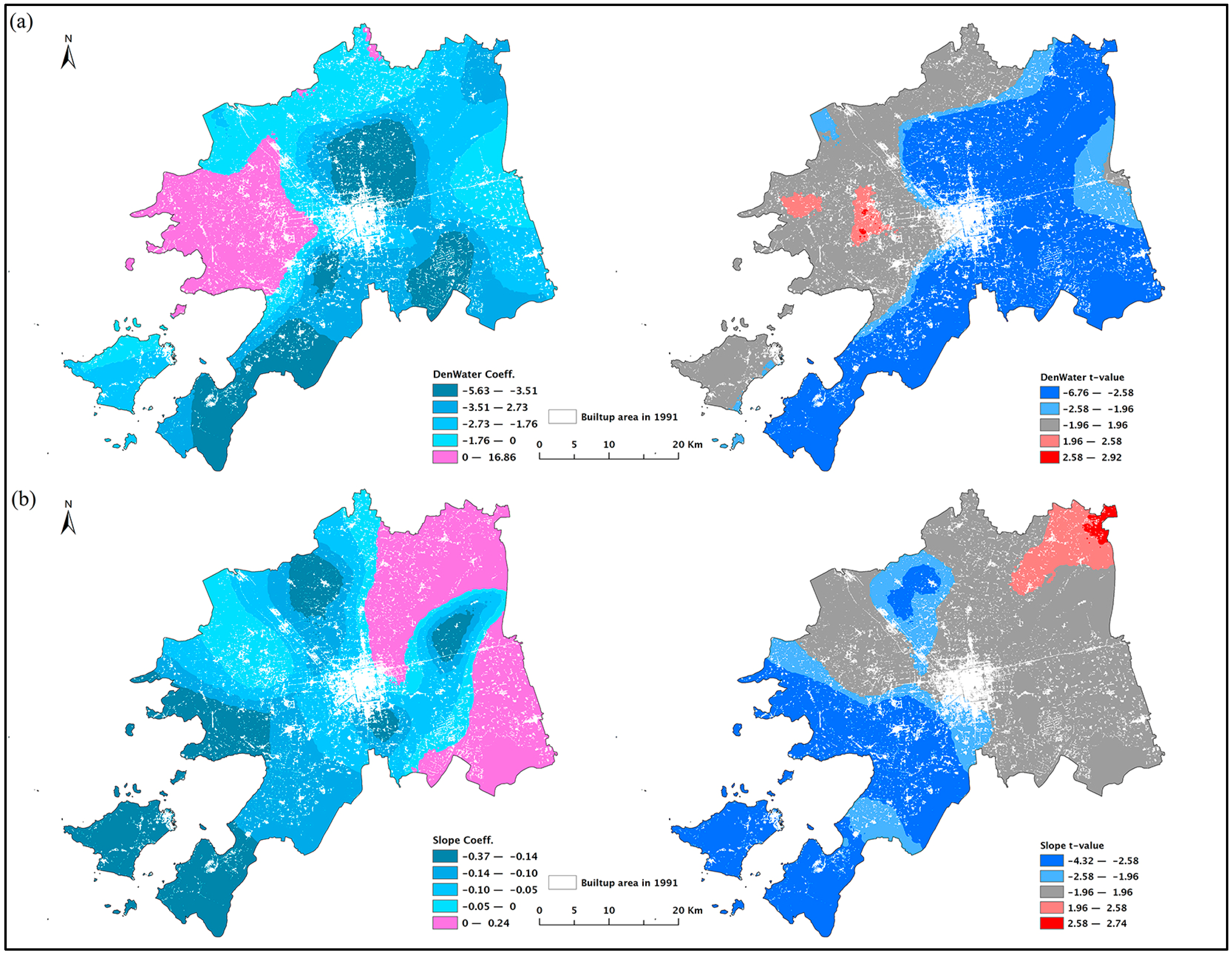
Figure 10 presents the parameter and
t-statistic surfaces of the three variables of proximity to transportation networks. While the global logistic regression model indicated that the distance to highways (Dis2Hwy) had positive influence on urban land development, the parameter surface of Dis2Hwy suggests that there were portions in the northwestern, northern, central, southeastern, and southwestern regions of the study area where the distance to highways had negative effect on urban land conversion (
Figure 10a). Negative coefficients of Dis2Hwy were significant in the north of the city (Caohu Industrial Park), to the east of the pre-growth urban core (Suzhou Industrial Park), in the south of the Dongshan Peninsula, and around the shoreline of Taihu Lake in the west of the city. This may indicate that the development of Suzhou Industrial Park (SIP) and Caohu Industrial Park (CHIP) depended more on intercity highways than other areas. SIP and CHIP are both export-oriented development zones, which imply that transportation planning should reinforce the importance of highways for export-oriented areas in the future. The distance to local arterial roads (Dis2Lard) had a dominantly negative influence on land conversion, except in a very small area in the north of the city (
Figure 10b). This influence was strongest next to the original urban core along an east-west axis and decreased towards south and north. The parameter of Dis2Lard was significant for most of the study area, except to the north of the pre-growth urban core and on the two islands where local roads mostly encircled mountains (
Figure 3). The global logistic regression model showed that the distance to railways (Dis2Rail) had a negative influence on urban land expansion. However, this was not true for the whole study area. The positive influence of Dis2Rail could be found in the northeastern part, east of the original urban core (Suzhou Industrial Park), and in the two islands, but the positive influence was significant only in the northeast and on the Dongshan Peninsula (
Figure 10c).
The logistic GWR model also revealed the spatial variation of the parameter estimates of the two variables for neighborhood physical conditions. The density of waters (DenWater) largely had a negative influence on land conversion, except in the western part (
Figure 11a). The western part of Suzhou does not have many large water bodies (
Figure 3), such as lakes and rivers, which are often protected. The parameter of DenWater was significant in most areas in the northeastern, eastern, southern, and southwestern regions of the study area. Representing the topographical conditions, slope generally exerted a negative impact on urban growth in Suzhou (
Figure 11b). However, slope did have a positive influence in the northeastern and southeastern parts of the city, where two large inland lakes, Yangcheng Lake and Cheng Lake, are located. The coefficients of slope were negatively significant in the southwestern part of the study area and positively significant only in the northeastern corner. The spatial distribution of slope in Suzhou confirms that the southwestern part has low mountains where the steep topography would adversely impact urban growth (
Figure 3).
Figure 12 presents the parameter and
t-statistic surfaces of the three socioeconomic variables. Although the distance to district center (Dis2Dcen) had a weaker negative influence in the global model, its parameter surface varied greatly across the space (
Figure 12a). This variable had a positive effect on urban land development in the northern, southeastern, southwestern, and northwestern parts of the city. The coefficients of Dis2Dcen were negatively significant in the northeastern (Yangcheng Lake) and southern (Wuzhong Economic Development Zone) regions of the study area and west and northwest of the original urban core (SND and Xushuguan Development Zone) and were positively significant only in a small portion of the southeastern, southwestern, and northwestern part of the study area. The global model demonstrated that urban development was not dependent on existing industrial centers. Logistic GWR found that this statement was oversimplified. Although the distance to industrial centers (Dis2Indu) had a positive influence to the south, west, and northwest of the pre-growth urban center and the northeastern part of the city, the parameter of Dis2Indu was positively significant only to the west of the original urban core and in the northeastern part of the study area (
Figure 12b). Coefficients of this variable were negatively significant only in a small portion of the southeastern part and in the southwestern part of the city. For the majority of the city, the parameter Dis2Indu was not statistically significant. Similarly, the density of built-up area (DenBuilt) had a dominantly positive influence on land conversion (
Figure 12c), but its parameter was not statistically significant in most parts of the city. Only in the north of the city and in the two islands were the coefficients of DenBuilt positively significant. These areas were less urbanized in the pre-growth period, and this may indicate that existing built-up area could play a more effective role in promoting urban growth in less mature areas.


