4.1. Significance of the Results
Our results showed that, regardless of the differences between the cities analyzed and between the two countries, in terms of the planning systems and socioeconomic dynamics during the study period, OGA were lost and fragmented in both Romanian and Polish cities between 2006 and 2018. Albeit alarming, this trend was consistent with other findings covering almost two decades [
4,
52]. Hence, the broader relevance of these findings is as follows:
From a theoretical perspective, the results provided additional evidence verifying the hypothesis, often repeated in the literature, regarding the crucial impact of urbanization processes on the fragmentation of OGA in special and UGI in general.
From a methodological perspective, the mathematical model of fragmentation, applicable to most European cities and potentially to any city with a concentric growth pattern, and invariant to the size of the city, proved its utility in bringing new and potentially different perspectives to the fragmentation process.
This study resulted in concrete recommendations for planners (presented in
Section 5). However, the main contribution of this article was the proof that, for the time being, these recommendations could be based solely on precautionary principles. Simply put, both the dedicated literature and the quality of the available datasets prevented us from making precise and mature recommendations for planning practitioners that were based on conclusive proofs. We believe this to be a major problem with current research practices, for reasons not sufficiently debated within the current literature.
Additionally, last but not least, even though some studies that were carried out separately in different countries were are available in the existing literature, very few investigations were carried out in several countries simultaneously, especially in countries with different planning systems.
Returning to our key findings, the significance of the loss and fragmentation affecting OGA and UGI should be analyzed separately. Given the ES it provides (from a socioeconomic perspective) and its diversity (from an ecological standpoint), its loss can be seen as a negative phenomenon. However, its fragmentation can be placed in a “gray” area of the literature, especially within landscape ecology. When reviewing empirical studies carried out at the landscape scale, Fahrig [
53] concluded that the ecological responses to habitat fragmentation per se (i.e., studies that were irrespective to the size of the habitat) were in most cases insignificant, while the most significant relationships were positive, as indicated by the increase in indicators such as species abundance, occurrence, richness, and other response variables to habitat fragmentation per se. This particular article drew upon an article making a contrary statement [
54], followed by a new set of arguments provided by Fahrig et al. [
55] supporting the claim that fragmentation was not “bad” per se. Since the present study did not deal directly with the ecological responses to the fragmentation, the only implication of the findings indicating the loss of UGI was a call for prudence, applying the precautionary principle.
Moreover, there are several local variations, especially related to the significance of drivers affecting the dynamics of OGA. An important limitation of this particular study lies in the fact that the statistical indicators differed from one country to another rather dramatically, ranging from measuring different indicators to measuring the same indicator in different ways. This is why the chosen set of indicators is confined to the common indicators, where by “common” we mean that they measure the same indicator in the same way.
Unfortunately, this explicit care did not always succeed in investigating some of the driving forces affecting the dynamics of OGA and UGI in depth. For example, in Romania data existed not only on the total length of roads in a given city, which usually showed little variation over time, but also on the modernization of roads, which could eventually result in the removal of adjacent vegetation rows. This indicator was identified as a significant driver for the fragmentation of OGA, for its loss, as well as for the overall balance, unlike the total length of roads. However, it could not be used in Poland, since it was computed in a different way. Similarly, unlike Poland, Romania did not have any indicators on the local Gross Domestic Product, and the only indicator for the overall state of the economy was employment. In summary, while the original plan was to check the influence of all the pillars of sustainability, except for the environmental ones, by selecting the most appropriate social, economic, and cultural indicators, we ended up with the indicators which permitted a comparison of both countries.
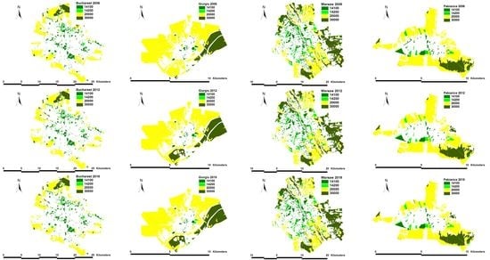
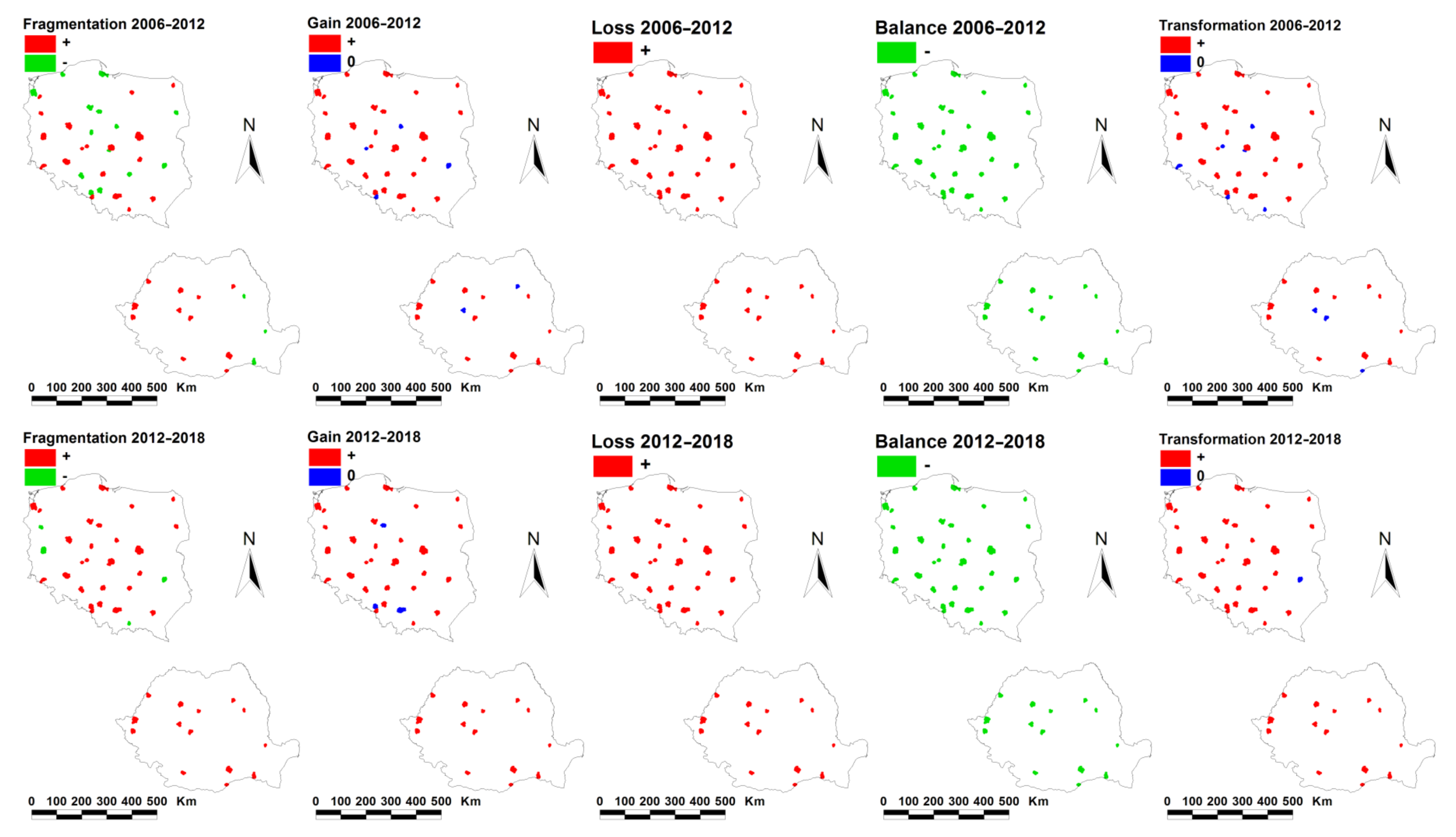
The different fragmentation trends, with several cities showing a constant compaction trend, must be correlated with the fact that the other results indicated a continuous loss of OGA. Against this background, we can easily infer that most of the small patches of OGA disappeared, and the remaining parts were found in untouchable areas (public parks and other types of green spaces). This explains both the compression and loss of OGA.
The vicious circle described by Petrişor et al. [
8] was also valid for the relationship between climate changes, GI, and planning: a well-planned GI could help mitigate climate changes, but changes to GI due to the lack of or poor planning were likely to increase the negative outcomes of climate changes. If we considered that post-socialist countries were more vulnerable to climate change [
56], this study made an important contribution to investigating the relationship between the effects of changing planning policies, particularly in the relationship with GI, and the ability to cope with the effects of climate change, strengthening the importance of addressing GI in planning, and helping to implement planning provisions addressing climate change issues.
4.3. Similarities and Differences between Poland and Romania
The studies aimed to compare two European countries, situated in different parts of the continent (Poland in the center and Romania in the east). Both Poland and Romania as new members of the European Union, are rapidly developing countries. As part of the Eastern Bloc, they differed from other emerging economies in terms of their transition periods, a fact that could, in principle, be generalized to other emerging economies. The two countries developed rapidly in the 21st century, and although they shared some historical background, switched very quickly to their current developing paths. Hence, the study was relevant for countries with a similar background.
Previous studies showed that the urban sprawl in Europe was influenced by the historical structure of cities [
23]. Furthermore, other studies pinpointed the influence of the planning system on integrating the concepts of GI and ES in the planning process [
18,
58].
Against this background, a simple look at the data reveals the differences between Polish and Romanian cities. Although their population does not differ significantly, the size of the Polish cities is significantly greater than that of the Romanian cities; roughly 2–3 times greater. Moreover, the share of OGA in Polish cities is significantly greater than in Romanian cities; roughly twofold. The local budget (revenues and expenditure) was significantly greater in the Polish cities from 2012–2018. Other differences were visible in the results we obtained: fragmentation was significantly greater in Romania from 2006–2012, and the overall balance, i.e., the difference between the area of gained and lost OGA, was greater in Poland during 2012–2018. Since the overall balance was a raw value, it could be explained by the significantly greater size of Polish cities.
Apart from these morphological differences, there were differences in the planning systems and in their dynamics as well. Although planning in general could play a key role in terms of enhancing OGA and maximizing their ES, there could also relevant differences between the Polish and Romanian planning systems.
The Polish planning system does not enforce, but instead stimulates the process of regulating different activities by plans. As a consequence, only a part of the administrative territory of the cities is covered by the plans. Since 2004, when the current law on spatial planning and development came into force, all spatial development plans adopted before 1 January 1995 lost their validity [
59]. These legal regulations covered approximately 75% of the country’s area. This decision should be assessed very critically; it meant that many communes, and also urban municipalities, were left with no binding spatial plans. The plans were introduced despite the discontent and protests of self-government authorities [
59]. As a result, some areas, previously protected by the provisions of spatial development plans, lost their primary protection.
In Romania, the planning system changed, but the planning process remained a long and arduous bureaucratic process [
60]. The law required the existence of different plans, from the Master Plan of an entire city, or what is called a General Urban Plan in Romanian planning parlance, to a detailed plan for each planning objective or investment [
60]. During the real estate boom, “derogatory planning” (i.e., legalizing deviations from the initial plan) accounted for most real estate developments [
61]. After 2008, the planning became affected by economic crisis, while the period before 2008 corresponded to changes in the planning system as a consequence of the accession of Romania to the European Union [
62]. As a consequence of changes in both periods, the plans at different spatial levels contradict each other [
62] and the built reality is markedly different from planned intentions [
63]. Furthermore, plans were drafted according to an outdated methodology, which lost connection with the progress of urban ecology [
64] and did not account for key concepts, such as GI and its ES, allowing for its fragmentation without understanding the importance of continuity for its normal functioning, and ultimately for the welfare and comfort of the urban population [
8].
An illustration might prove beneficial at this particular point. In Romania, each urban planning document follows a relatively similar development path. First, a design brief, with its associated terms of reference, is produced, either by a planning authority or by a team of consultants, hired for this task by the planning authority. Then, after a contract is signed, with the brief and the terms of reference as annexed to the contract, the drafting of the planning document commences.
The drafting process comprises four distinct stages: Firstly, a series of background studies are produced, which aim to support the proposals contained within the future planning document. Secondly, a preliminary version of the planning document is drafted by the design team. “Preliminary” in this sense means that the planning document is a development of an urban planning perspective. Once endorsed by the relevant local Technical Committee for Spatial and Urban Planning, which oversees urban development and acts in all major Romanian cities, the planning document enters its third stage, namely the application for notices and agreements from the relevant authorities. It is within this third stage that the planning document might suffer additional changes in order to correspond to various technical and legal requirements. After the successful completion of this third stage, the planning document is now in its final version, and can therefore be approved by the Architect in Chief, with the support of the same Technical Committee for Spatial and Urban Planning that we mentioned earlier. Once approved, it then enters its fifth and final stage, namely the endorsement by the Municipal Council.
It is plain to see that the pivotal component in this entire procedure is the quality of the design brief and of its associated terms of reference, which, as discussed earlier, become mandatory provisions through the inclusion in the contract. Now, the crux of the matter is that most Romanian design briefs, but not all, fare extremely poorly when assessed from a scientific perspective. The provisions related to GI are either completely absent, or else they are surprisingly weak, expressed in terms that became obsolete decades ago. Furthermore, the overwhelming majority of design briefs bow to the recommendations made by outdated technical guidelines, which have not been updated for over two decades. To complicate things further, even if newer-generation design briefs stand to correct this unfortunate state of affairs, they usually run the risk of being contested by potential bidders during the public procurement process.
Returning to our main argument, derogatory planning usually results in detailed plans which violate the provisions of General Urban Plans and oppose the initial planning goals [
62] in order to legalize the developments occurring under political or economic pressure. Moreover, the legal requirement of updating the General Urban Plan every 5 to 10 years is not enforced with bureaucratic procedures resulting, under politically unstable conditions, in missed deadlines. At the three points in our study period (2006, 2012, and 2018), some cities did not have an updated plan with the validity of the previous plan being somewhat developed, or with a new plan drafted but not legally approved.
In contrast, the current spatial planning system in Poland was built up under political transformation conditions and based on the axiological assumption according to which the right to protect real property ownership could be extended to the right of land development. This meant that every property owner, by virtue of the act itself, had the right to develop it [
59].
This right can be limited (forfeited) when pursuant to the current provisions, i.e., the local spatial development plan (or local plan). Its provisions cannot breach the arrangements of the document which determines the spatial policy of a certain commune, i.e., the study of determinants and directions of spatial development (called ‘study’). This study is a mandatory document, drawn up for the area of an entire commune, but it is not generally binding; therefore, no administrative decision can be based on it [
65,
66].
Unlike the study, local plans are not mandatory and only some parts of a commune can be included. Such plans are usually prepared for building-free areas (agricultural), stimulating the excessive development of urban areas over adjacent territories. Nevertheless, vast areas of cities and communes (municipalities) are not included in the plans; this does not mean there is no possibility of investing there. The administrative decisions on building conditions can still be applied in the areas not covered by plans. These decisions do not need to be compatible with the study and allow building development in areas with no technical infrastructure.
It is worth noting that, in the case of issuing building conditions, an investor, and not a commune, makes decisions on the land designation. Such a liberal law results in the fact that the construction industry can develop in an unplanned way in places preferred by investors, including floodplains, areas with significant landscapes and environmental assets, etc. This results in a decreasing in the functional efficiency of cities and their capacities for effective and sustainable development, deteriorating the quality of the natural environment and increasing the pressure on building-free areas (including the green areas). The adopted planning solutions refer, to a small extent, to the basic spatial planning principles, which ensure spatial order and sustainable development in Poland. Because of this, the Polish spatial planning system is widely criticized in the literature [
59,
65,
66]. Its weaknesses are proven, among others, by the results of the study conducted in selected Polish cities by the Supreme Audit Office in 2017; they show that, despite the expansion of the area covered by local plans, many cities recorded a decrease in the share of green areas and water in the total area structure included in the local plans [
67].
Against this background,
Table 6 presents a comparison between the studied cities in the country-specific planning context: the existence and updating with plans in Romania, and the share of the city area covered by plans in Poland. The latest decreases during some periods and in some cities (2006–2012 in Gdańsk, 2012–2018 in Opole and Zielona Góra) are explained by the fact that the city area increased and the existing plans covered a smaller part of it.
In summary, the lack of coverage by plans in Poland and the derogatory over-planning in Romania had the same effect: development occurred spontaneously, driven by economic and political forces, and did not account for GI, which were fragmented and lost in both countries.
4.4. Study Design
The study employed an ecological approach, which is, by design, subject to the “ecological fallacy”, meaning that the conclusions obtained at the population level are generally not valid at the individual level [
68] due to spurious correlations. For instance, a country-wide analysis indicates that the loss of OGA, measured by the difference in area between 2006 and 2012 or 2012 and 2018, is significantly greater in Poland than in Romania, simply because Polish cities are larger than their Romanian counterparts. If the loss is measured as a ratio between the difference in area and city size in 2006 and 2012, or 2012 and 2018, the difference is no longer significant. Furthermore, the ecological fallacy relates to confounding, when variables which are not functionally related appear to be correlated because both are tied to the same third variable. This confounding of results causes a spurious correlation between the raw gain and loss of OGA, both related to city size. Regardless of its inherent shortcomings, the ecological approach has the theoretical advantage of allowing the simultaneous comparison of large amounts of information; therefore, 46 cities are analyzed in the study, with the caveat of relying mostly on quantitative data and treating event qualitative data in a quantitative manner, i.e., integrating it the ANCOVA prediction model. In addition to this, the validity of the approach is proven by its use in studies from other fields, including management, health, sociology, geography, or political studies, to name only a few [
69,
70,
71,
72,
73].
The ANCOVA prediction model is also subject to limitations: We already pointed out the issue of data availability at the city level, which resulted in a lesser coverage of the economic and social aspects of sustainability. Nevertheless, with this caveat in mind, the model has the theoretical advantage of being able to address the traditional pillars of sustainability (economy, society, and environment), but also some additional dimensions of the concept, i.e., infrastructure, demography, and administration. In addition, its validity results from totaling predictors found to be significant for the dynamics of GI by other studies.
Although the mathematical model used in this study is a novel approach, the findings are consistent with those of previous studies, thereby validating it implicitly, in addition to its mathematical proof. However, the main limitation of this model is that it relies on the radial-concentric geometry of cities. Further research is needed to derive similar models for other shapes, keeping in mind that its development starts from the condition of creating a model that is invariant to the original size of the initial city shape.
4.5. Data and Methodological Limitations, and Future Research Directions
Due to the nature of the data, we deliberately and justifiably assumed several limitations for this study. It must be pointed out that, despite the free availability of European geospatial data such as CORINE or the Urban Atlas, datasets are continuously subject to changes intended to improve them, both in terms of resolution and classification schemes. However, these changes also entail important limitations, with the difficulty of conducting comparative analyses being chief among them [
74]. In our case, the different classification scheme used in 2006 compared to 2012 and 2018 was overcome by reclassifying the newer datasets, thereby diminishing their resolution. Future research using newer data would naturally benefit from a more complex classification scheme, but analyses aimed at searching an entire period will have to deal with this issue for the 2006 data.
At the same time, we decided to limit our analyses to GI corresponding to OGA. Future studies could also take into account GI and even “blue-green infrastructure”, since the data are already available. Nevertheless, the inability of discerning between changes in infrastructure which are due to human interventions or have different underlying causes still remains.
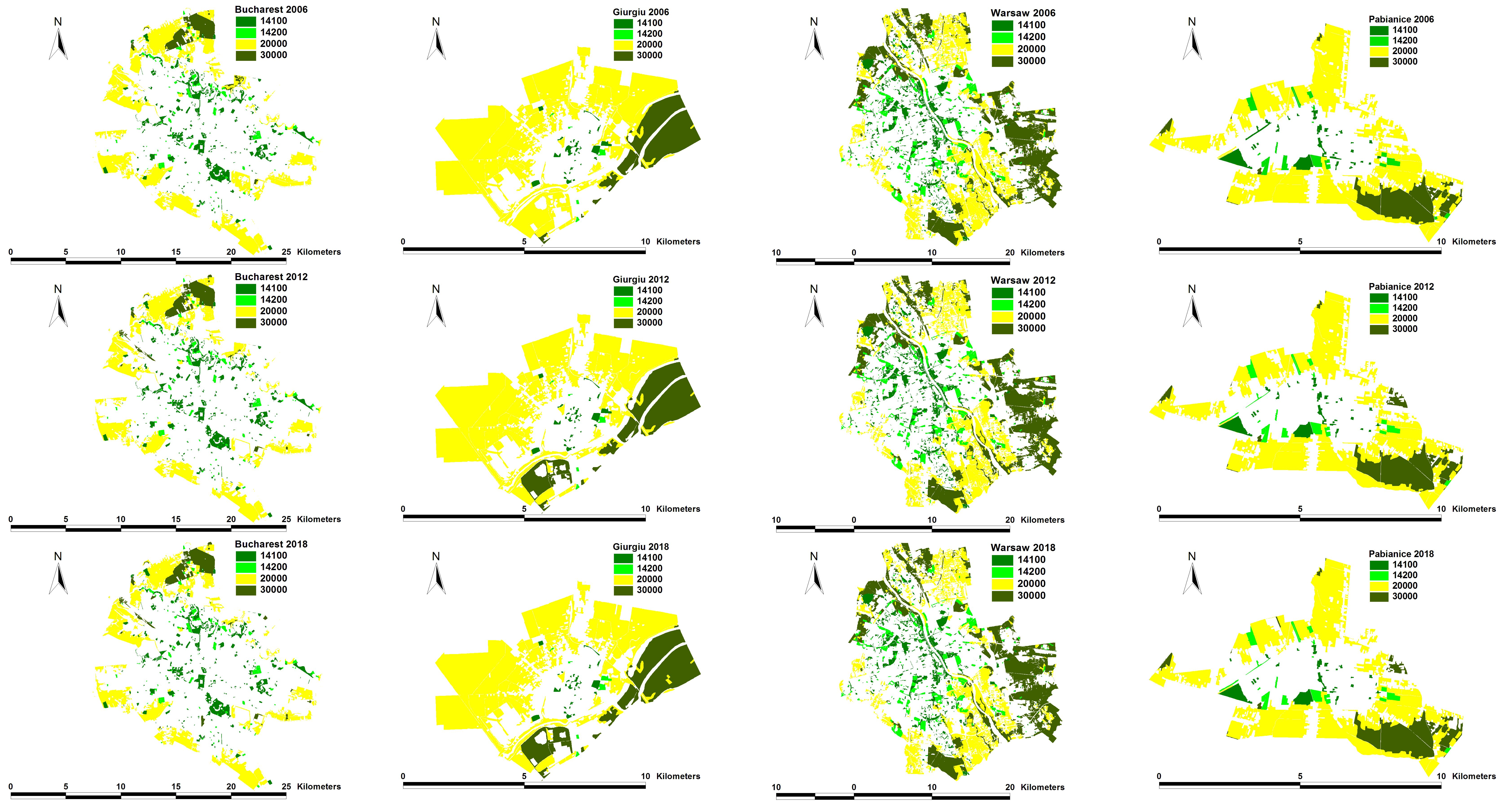
Last but not least, for comparison purposes the analysis was limited to the cities covered by Urban Atlas data in all the three periods analyzed, while statistical analyses were carried out only for those cities where data on the different drivers was available. This was another limitation likely to affect the future studies, since the data could not be produced retroactively. While the limitation is inherent to the data and cannot be addressed, future studies could focus on the more recent periods, provided that the data include more cities. At the same time, future studies focusing on recent data will benefit from using larger samples and cities that might be more relevant for statistical purposes (for instance, large Romanian cities, such as Iași, Brașov, Constanța, or Galați, meeting the population criterion, were not included in the analysis due to the lack of available data for 2006).
In methodological terms, the characteristics of the study team allowed for a simple and intuitive spatial analysis, able to translate the spatial data into numbers that could be analyzed statistically, task accomplished using ArcView GIS 3.X. Future studies could consider using more recent pieces of software, such as QGIS and its Phyton language script, which are able not only to collect data, but also to pinpoint the most and least correlated areas, allowing for the involvement of “a broader audience” and a better visualization of the final output, tools that ultimately improve the decision-making process.
In conceptual terms, our study was strictly focused on the dynamic of OGA in relationship to the drivers influencing it and the planning perspective. However, moving to the landscape scale, there were other issues worth exploring, such as the effects generated by urban transformations on landscape, their relationships with ecological connectivity, and the economic attractiveness that may be generated in a city or territory [
75,
76], or the relationship with the global resilience, in particular to climate change.
Against this background, we can now sum up the main limitations of this study. Hence, we know that all FUAs under scrutiny lost OGA over the period between 2006 and 2018. However, we do not know precisely which kind of GI were lost. Additionally, perhaps even more importantly, we can only formulate recommendations based on precautionary principles, given the quality of the available data.
Each of the previous statements requires a brief explanation. Hence, as mentioned earlier, FUAs encompass more than one municipality. Moreover, FUA boundaries do not always overlap administrative boundaries, which are the main units for census data. Therefore, we cannot confirm a FUA-wide analysis by using additional, finer-grained examinations, aimed at probing the real situation of GI within the administrative boundaries of the constituent municipalities. This is a problem, especially when most of the green open spaces within any given FUA are located across its periphery, and not within its core. Consequently, when we talk about losing GI, we usually mean losing GI at the fringes of the FUA, generally due to the urban sprawl generated by its core. Moreover, this infrastructure consists mostly of agricultural and natural areas, with urban green open spaces or leisure areas being far less common. However, the lack of overlap between FUA and administrative boundaries prevents us from pinpointing the exact amount and position of the lost GI in relation to each municipality’s administrative boundaries. Therefore, we can only say that FUAs lose OGA, most likely at their fringes, where the urban sprawl generated by the core transforms green open spaces into built-up areas. At the same time, better planning recommendations can be phrased through the lens of the four types of urban nature; if the city growth the likely to eliminate and fragment natural areas with their biodiversity, planners can provide for landscaped areas connecting remaining natural islands and ensuring the provision of ES, compensating for the lost ones. In this regard, studies using a fine-grained classification of different types of GI can provide more specific recommendations.
Secondly, it is very important to stress that satellite imagery tells us very little about land use, and, even more importantly, about development rights enshrined within the legal status of each plot. Hence, the administrative anatomy of an FUA is further complicated by the fact that each constituent municipality is governed at least by one urban plan, i.e., the general urban plan for the entire municipality, or a series of zonal urban plans, for different areas within that municipality. It is these plans that affect development rights and might consequently distort the interpretation of satellite imagery. In other words, plots which have not yet been built or that still lie derelict, even if construction is legally possible, might be covered by greenery, and thus appear as part of GI. Moreover, there is a fine line when classifying wooded areas as “forests”, based on the canopy coverage and depending on the spatial resolution of the image. In other words, only large developments may be classified as “change”, while small transformations cannot always be detected.
It is against this background that we can only formulate recommendations based on precautionary principles, because of the gaps in the scientific literature and quality and availability of the data. This is a crucial point to be made, as our recommendations eventually filter through to planning regulations, which are opposable in a court of law [
77].


 ,
, 


