1. Introduction
Rainfall is considered the most critical element of the hydrological cycle, as it affects the environment both directly and indirectly [
1]. It plays a vital role in understanding the mechanism and interaction of global water and energy balance and is the main input of hydrometeorological models and climate studies [
2,
3]. Usually, rainfall measurements are performed using station-based rain gauges. However, rain gauge-based techniques for rainfall observations have non-negligible limitations in eco-hydrology research because of their large spatial nonuniformity and temporal availability in rainfall fields [
4].
Similarly, Dinku [
5] argued that vulnerabilities due to climate variabilities and changes in Africa urged the need for quality climate data where agriculture is dependent on subsistence rain-fed farming [
6]. Hence, rainfall-related studies require due attention to sustain millions of lives. However, the distribution and availability of ground-based rainfall data in Africa are sparse and rare [
5], particularly in countries such as Ethiopia. This limits the scope for conducting in-depth research in hydrometeorology and climate-related studies. Nevertheless, the availability of remotely retrieved rainfall data at different spatial and temporal resolutions has accorded a breakthrough in the development of a wide range of studies in various disciplines and supplemented ground-based rainfall estimates. Some freely available spatially distributed satellite rainfall products include the merged satellite-gauge rainfall estimate (IMERG), tropical rainfall measuring mission (TRMM), rainfall estimation from remotely sensed information using artificial neural networks—climate data record (PERSIANN-CDR), national oceanic and atmospheric administration (NOAA), climate prediction center morphing technique (CMORPH), multi-sensor precipitation estimate–geostationary (MPEG), the multi-satellite precipitation analysis (TMPA) near-real-time product (3B42RT), climate hazards group infrared rainfall with station data (CHIRPS), African Rainfall Climatology (ARC v2) and tropical applications of meteorology using satellite data and ground-based observation (TAMSAT), the Global Satellite Mapping of Precipitation (GPMaP_NRT), and others.
These different satellite rainfall product comparisons have been widely evaluated to validate whether rainfall estimation accuracy is affected by convective or orographic effects in different parts of the world—e.g., in China [
7], the Tibetan Plateau [
8], Brazil [
9,
10], Morocco [
11], and East Africa [
5,
12,
13,
14,
15,
16,
17,
18,
19,
20]—to demonstrate which products present the greatest potential for use in specific environments.
Gella [
19] evaluated six satellite products (CHIRPS, TAMSAT, TRMM-3B42RT v7, PERSIANN-CDR, ARC v2, and CMORPH) over Eastern Ethiopia in the Wabi-Shebele River Basin. He found that TAMSAT has a relatively better capability for detecting rain events. In addition, it was found that all the products underestimated the rainfall amount in the region. Furthermore, Romilly and Gebremichael [
18] evaluated TRMM 3B42RT, CMORPH, and PERSIANN rainfall products in Ethiopian river basins. They showed TRMM 3B42RT and CMORPH tended to overestimate rainfall at low elevations but provided reasonably accurate results at high elevations of the river basins. On the other hand, PERSIANN provides reasonably accurate values at low elevations but underestimates at high elevations. Dinku et al. [
21] compared CMORPH and TRMM-3B42RT, and TRMM-3B42 rainfall products in the western highlands of Ethiopia and the highlands of Colombia. They reported that the occurrence of rain was underestimated for all products. Hirpa et al. [
17] compared CMORPH, TRMM-3B42RT, and PERSIANN in a large river basin of Ethiopia with wider elevation ranges. The researchers found that TRMM-3B42RT and CMORPH underestimated at higher elevations; however, these products also exhibited elevation-dependent trends. Nevertheless, the PERSIANN products did not exhibit any trends for the specific study area. In mountainous Northwest Mexico, Nesbitt et al. [
22] found that CMORPH and PERSIANN overestimated the rainfall rate and frequency; TRMM-3B42 estimates agree well with the observed rainfall. In the same basin of Northwest Mexico, Hong et al. [
2] found that PERSIANN-CCS products overestimated rainfall at lower altitudes and underestimated the rainfall in highlands. It has also exhibited an elevation-dependent bias in the region.
Gebere et al. [
13] compare the performance of three satellite rainfall products (TRMM 3B42, Global Satellite Mapping of Precipitation (GSMaP)_MVK+, and PERSIANN) in the data-scarce Wabi-Shebele River Basin. They used a point-to-grid comparison to evaluate using the satellite product using different categorical indices. In this river basin, TRMM and PERSIANN performed well as compared to GSMaP. Moreover, Derin et al. [
13] used nine global-scale high-resolution satellite-based rainfall (SBR) on different complex terrains of the world. As part of the research focus area, the Blue Nile in the Eastern Africa region was considered, and they found that the SBR products underestimate wet season and overestimate dry season precipitation. Investigation of the extreme rainfall rates using the satellite retrieved rainfall product in the Upper Awash River Basin for flood and drought monitoring systems was studied by Mekonnen et al. [
13]. Their study was categorized on the basis of the type of sensors (infrared or microwave) and topographic elevation conditions (highlands/lowlands). They found that microwave-based SREs effectively captured/detected the high rainfall rates while infrared-base SREs detected the low rainfall rate.
Reviewing the above studies, particularly those based in Ethiopia, most evaluated the rainfall products; however, only a limited number of authors validated comparisons with the ground observed data in a few locations in Ethiopia [
2,
19,
23]. Different studies have indicated that no single satellite rainfall performs best in all types of climatic and topographic conditions. Therefore, a site-specific satellite rainfall evaluation at the sub-basin level is recommended [
13]. In this study, the products that were not studied by previous researchers, but which have been recommended for hydrological and water resources studies, particularly in the Awash River Basin (ARB), were used to evaluate and compare rainfall products (IMERG, TRMM 3B43v7, PERSIANN-CDR, and GSMaP) with ground-observed station data across a varied elevation range, i.e., 240–4187 m, in the central and northeastern parts of Ethiopia. This study helps to identify and select the relatively best-fitted rainfall product at a specific sub-basin level for use in extreme rainfall analysis, frequency of rainfall, flood and drought forecasting, and synchronization with the hydrologic model to predict the flow of water in a basin.
This study aimed to evaluate and compare the rainfall estimates derived from IMERG, TRMM 3B43v7, PERSIANN-CDR, and GSMaP_NRT with ground-observed data. The remainder of this paper is organized as follows.
Section 1 presents the introduction and objective of this study.
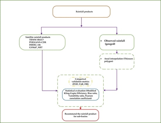
Section 2 includes the areal description and methods used to compare the satellite rainfall estimation.
Section 3 presents the results and
Section 4 presents the discussion. Conclusions are presented in
Section 5 of this article, and future recommendations are given in
Section 6.
4. Discussion
Dinku et al. [
15] validated different satellite rainfall products of CMORPH, TRMM 3B42RT, and TRMM 3B42 over the complex terrain of Ethiopia. They found that the occurrence of rain was underestimated for all the products. Hirpa et al. [
17] evaluated CMORPH, PERSIANN, and TMPA products in ARB—all three resulted in underestimation at higher elevations using the mean annual temporal scale. However, the PERSIANN rainfall products exhibited no trends for specific areas. Romilly and Gebremichael [
18] evaluated the satellite rainfall estimates over Ethiopian river basins. They concluded that the bias in the satellite rainfall estimates in Ethiopian river basins depends on the rainfall regime and, in some regimes, the elevation. The findings of these studies, as stated in
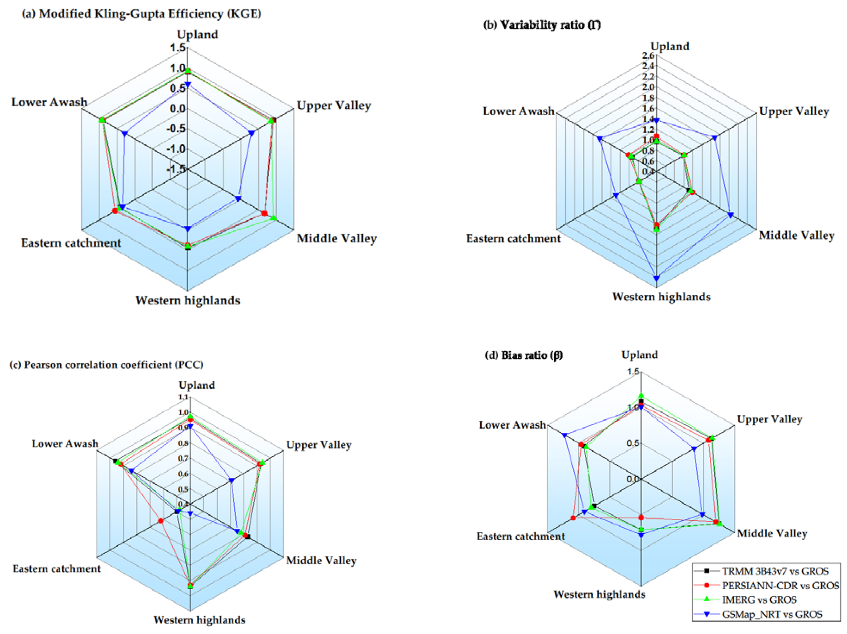
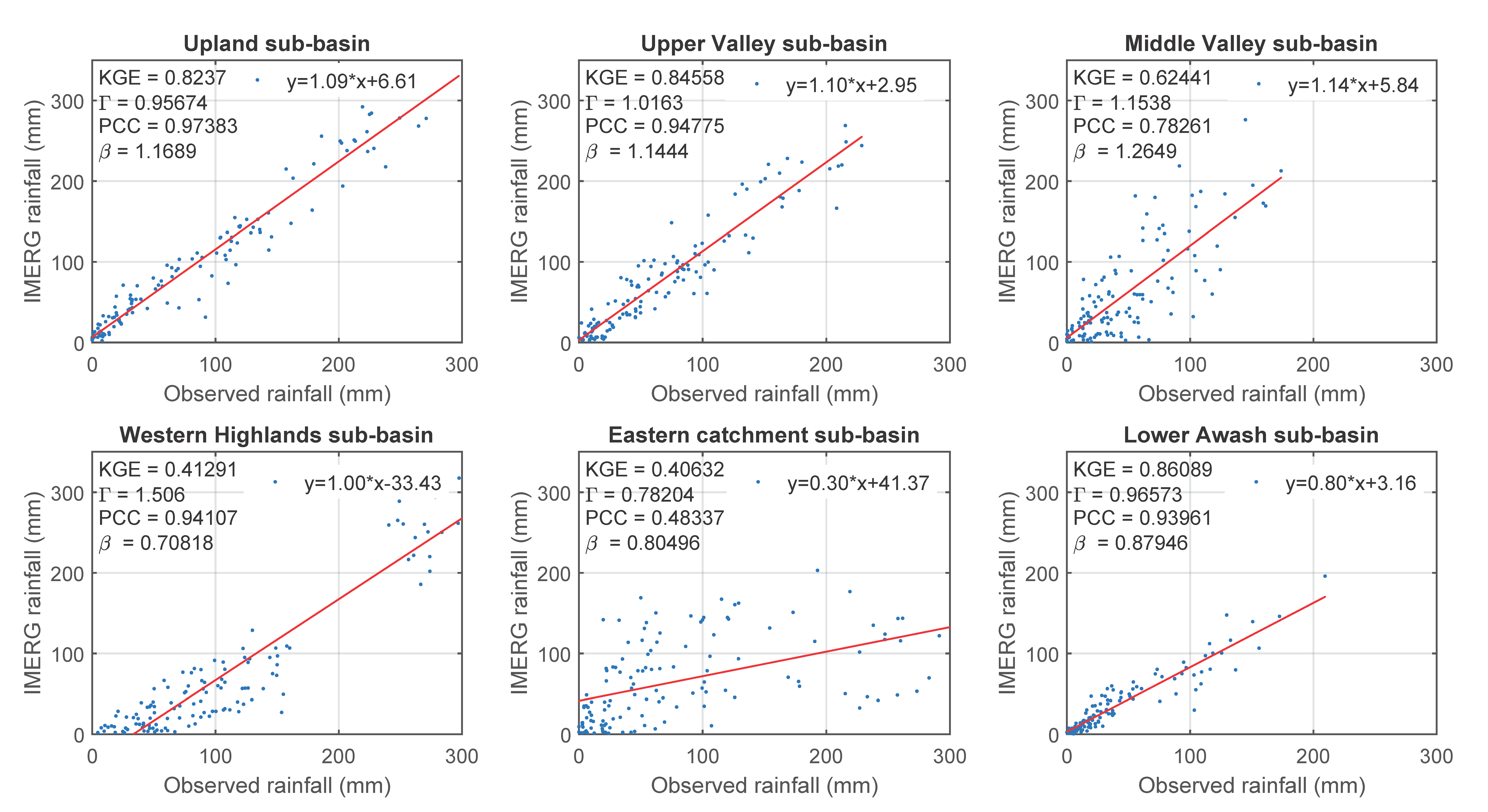
Section 3.4, shows that TRMM 3B43v7, PERSIANN-CDR, IMERG, and GSMaP_NRT rainfall products exhibited no monotonic trends at a 5% significance level in all six sub-basins of the Awash River, except that the GSMaP_NRT showed an increasing trend in the upland sub-basin. However, a linear regression pattern was observed for all sub-basins.
Furthermore, Mekonnen et al. [
13] concluded that microwave sensors showed the highest performance in capturing high rainfall rates while infrared-based SREs captured the low rainfall rates. In the ARB, the uplands and the western highlands receive high rainfall and contribute to a continuous flow of the Awash River. In this basin, the microwave sensors (TRMM 3B43v7 and IMERG) showed relatively low PBIAS and the highest performance in capturing the high rainfall rate. The PBIAS in upland sub-basin exhibited 8% (in TRMM 3B43v7) and 16% (in IMERG v06). In contrast, the PERSIANN-CDR (infrared-based SREs) performed weakly (PBIAS of −46%) in the western highland sub-basin, which receives high annual rainfall. Moreover, the microwave sensor SREs (TRMM 3B43v7 and IMERG v06) showed a PBIAS of −29% in both rainfall products. The IMERG SREs detected the highest POD, followed by TRMM 3B43v7 and PERSIANN-CDR in these two sub-basins. Gebere et al. [
13] found GSMaP rainfall estimate performed poorly in the Wabi-Shebele river basin, which has the largest share of the eastern parts of Ethiopia. Some portions of this eastern part of Ethiopia also drain into Awash River, and a comparison of these rainfall records with GSMap SREs resulted in poor performances. In conclusion, satellite rainfall estimates provide better options in sparsely gauged areas with unreliable observed data availability, which affects the hydro-climatic analysis for preventing flooding and impairing the livelihood of society in the ARB, Ethiopia.


