Article

Mapping Leaf Mass Per Area and Equivalent Water Thickness from PRISMA and EnMAP

1
School of Geographical Sciences, Southwest University, Chongqing 400715, China
2
State Key Laboratory of Remote Sensing Science, Faculty of Geographical Science, Beijing Normal University, Beijing 100875, China
*
Author to whom correspondence should be addressed.
Remote Sens. 2024, 16(21), 4064; https://doi.org/10.3390/rs16214064
Submission received: 10 September 2024 / Revised: 29 October 2024 / Accepted: 30 October 2024 / Published: 31 October 2024
(This article belongs to the Section Remote Sensing in Agriculture and Vegetation)

Abstract

:
With the continued advancement of spaceborne hyperspectral sensors, hyperspectral remote sensing is evolving as an increasingly pivotal tool for high-precision global monitoring applications. Novel image spectroscopy data, e.g., the PRecursore IperSpettrale della Missione Applicativa (PRISMA) and Environmental Mapping and Analysis Program (EnMAP), can rapidly and non-invasively capture subtle spectral information of terrestrial vegetation, facilitating the precise retrieval of the required vegetation parameters. As critical vegetation traits, Leaf Mass per Area (LMA) and Equivalent Water Thickness (EWT) hold significant importance for comprehending ecosystem functionality and the physiological status of plants. To address the demand for high-precision vegetation parameter datasets, a hybrid modeling approach was proposed in this study, integrating the radiative transfer model PROSAIL and neural network models to retrieve LMA and EWT from PRISMA and EnMAP images. To achieve this objective, canopy reflectance was simulated via PROSAIL, and the optimal band combinations for LMA and EWT were selected as inputs to train neural networks. The evaluation of the hybrid inversion models over field measurements showed that the RMSE values for the LMA and EWT were 4.11 mg·cm−2 and 9.08 mg·cm−2, respectively. The hybrid models were applied to PRISMA and EnMAP images, resulting in LMA and EWT maps displaying adequate spatial consistency, along with cross-validation results showing high accuracy (RMSELMA = 5.78 mg·cm−2, RMSEEWT = 6.84 mg·cm−2). The results demonstrated the hybrid inversion model’s universality and applicability, enabling the retrieval of vegetation parameters from image spectroscopy data and offering a valuable contribution to hyperspectral remote sensing for vegetation monitoring, though the availability of field measurement data remained a significant challenge.

1. Introduction

Leaf biochemical traits are essential for comprehending ecosystem dynamics, environmental transformations, and the growth and physiological condition of plants [1]. These traits facilitate predictions on alterations in community structure and ecosystem functioning [2]. Leaf Mass per Area (LMA) and Equivalent Water Thickness (EWT) are the primary leaf traits that provide insights into vegetation ecology, water stress, health status, and relative growth rates [3,4,5]. The ratio between leaf dry mass and area determines LMA, which is one of the six categories of essential biodiversity variables used to monitor ecosystem structure [6]. The LMA plays a crucial role in determining vegetation’s ecological strategy, reflecting the plant’s capacity to capture light energy and quantifying the efficiency of plants in nutrient uptake and use [7,8]. The LMA profoundly impacts leaf thickness [9,10], quality, and longevity, as a higher LMA correlates with longer lifespan and improved nutrient retention [11,12]. There is a consistent relationship between leaf nitrogen concentrations and LMA across various ecosystems [13,14]. On a broader scale, LMA significantly contributes to species’ adaptability to their environment, influencing various ecosystem processes, and reflecting vegetation’s dynamic response to spatial and temporal environmental changes [15,16,17]. LMA measurements have diverse practical applications, including predicting wildfire occurrence and spread [18,19]. In contrast to LMA, EWT is defined as the ratio of the difference between leaf fresh mass and dry mass to leaf area. EWT is a widely utilized indicator to characterize plant transpiration and respiration processes, influencing vegetation growth strategies [20,21]. EWT is also associated with vegetation’s physiological conditions and the status of terrestrial ecosystems, making it crucial for comprehending the functioning of Earth’s ecosystems. Evaluating moisture stress symptoms in vegetation using the EWT can aid in assessing drought conditions in forestry and agriculture [22,23]. The rate of forest fire spread is directly correlated with the EWT, making it a critical parameter for wildfire risk assessment [24].
Quantitative research on vegetation traits is fundamental for assessing the dynamic responses of vegetation to environmental changes [25]. In determining the LMA and EWT, insitu measurements are widely acknowledged as the most reliable approach. However, data obtained through field measurements only reflect a small area around the sampling points and are limited to a relatively short timeframe. Conducting in situ measurements involves deploying numerous sampling points, incurring high time and economic costs. Remote sensing effectively realizes the requirements of wide spatial coverage and continuous temporal monitoring in vegetation studies, enabling rapid, non-destructive, and precise data acquisition [26,27,28]. Different studies selected different spectral bands to invert LMA and EWT. Féret et al. emphasized that the accurate estimation of LMA and EWT relied heavily on determining the optimal spectral range [29]. They explored numerous spectral ranges between 1000 and 2400 nm and then suggested iterative optimization over the range between 1700 and 2400 nm for determining the EWT and LMA. Wang et al. determined that the best spectral bands for retrieving the LMA are situated at 1649 nm and 1722 nm [30]. Chen et al. found, through wavelet transform, that the most robust characteristic spectral bands for LMA retrieval are 1639 nm and 2133 nm [31]. Ali et al. conducted a sensitivity analysis across the full spectrum and concluded that the wavelength most sensitive to changes in leaf dry matter content was 2298.69 nm, while the wavelength most sensitive to changes in a specific leaf area was 2280.71 nm [32]. Wan et al. proposed the Adjusted Ratio of Difference Spectral Index (ARDSI). They determined that ARDSI2200,1640,2240,1720 exhibited optimal inversion performance for the LMA, while ARDSI1360,1080,1560,1240 showed the best inversion performance for the EWT [33]. For the retrieval of the EWT, the wavelengths 1080 nm and 1360 nm in ARDSI1360,1080,1560,1240 closely resembled those in the Normalized Difference (ND) index at 1062 nm and 1393 nm, all being strongly associated with the absorption characteristics of the EWT [4]. The wavelength of 1240 nm was also crucial for estimating EWT, as proposed by Gao in the development of the Normalized Difference Water Index (NDWI) [34]. Sims and Gamon indicated that the optimal bands for EWT retrieval were located between 1150 and 1260 nm and between 1520 and 1540 nm [35].
Spectral indices are commonly utilized across various inversion methods owing to their simplicity and efficiency, necessitating only a small number of selected reflectance bands. Lemaire et al. utilized the normalized difference index NDLMA [36], while Wang et al. employed the Normalized Dry Matter Index (NDMI) [30], both achieving LMA inversions. Many studies utilize vegetation indices sensitive to canopy liquid water content for inverting EWT, such as the NDWI [34], the Water Index (WI) [37], and the Simple Ratio Water Index (SRWI) [3]. Wan et al. proposed ARDSI to estimate the LMA and EWT at both leaf and canopy scales [33]. Non-parametric regression techniques are also frequently employed for inverting vegetation parameters, utilizing inherent learning algorithms to optimize regression without needing explicit relationships between spectral features and vegetation variables. This method adjusts weight coefficients to minimize errors, enabling training with full spectrum information without the need for specific bands or transformations. However, the redundancy of band information and computational efficiency may impact model performance. Hauser et al. combined physical modeling with a support vector regression algorithm to invert LMA, demonstrating a reasonable correspondence between inversion results from Sentinel-2 imagery and in situ measurements [38]. Campos-Taberner et al. used an inversion method based on the PROSAIL model and random forest regression to produce global maps of canopy water content using MODIS data [39]. Additionally, machine learning techniques have been employed to establish relationships between vegetation indices and traits, making them sensitive to leaf biochemical components and capable of addressing nonlinearities [40]. Based on Gaussian process regression and PROSAIL, Zhang et al. constructed a hybrid model that compared the performance of GaoFen-1 band combinations and vegetation indices for inverting the Leaf Area Index (LAI) [41].
Previous studies on the inversion of LMA and EWT have primarily relied on airborne hyperspectral imagery or spaceborne multispectral remote sensing data. Airborne imagery provides high spatial and spectral resolution and allows for flexible target selection and acquisition timing based on experimental needs. However, the high financial and labor costs have significantly reduced the feasibility of acquiring large-scale, multi-temporal data [42]. Additionally, spaceborne multispectral data are limited by sampling only a few spectral bands, restricting the acquisition of complete spectral information. In contrast, spaceborne hyperspectral observations overcome the spectral limitations of multispectral sensors and the high costs of airborne hyperspectral imaging, enabling the cost-effective acquisition of multi-temporal, high-resolution spectral images [43]. With the advancement of hyperspectral imaging spectrometers, quantifying plants’ physiological and biochemical traits has become more accurate. Hyperspectral remote sensing enables rapid and non-destructive capture of subtle spectral information from surface vegetation, thereby facilitating the precise inversion of required vegetation parameters. Recently launched satellite missions, such as the Environmental Mapping and Analysis Program (EnMAP) (https://www.enmap.org/, accessed on 17 October 2024) and the PRecursore IperSpettrale della Missione Applicativa (PRISMA) (https://www.asi.it/scienze-della-terra/prisma/, accessed on 17 October 2024), have generated large-scale spectral data streams for land monitoring. Verrelst et al. integrated physics-based models with machine learning algorithms to develop a hybrid model, which was applied to PRISMA imagery to map canopy nitrogen content [44]. Pascual-Venteo et al. effectively addressed the challenge of mapping canopy characteristics from EnMAP and PRISMA hyperspectral imagery at the top-of-atmosphere level by devising a hybrid model [45].
With the objective of mapping LMA and EWT from EnMAP and PRISMA, this study first built hybrid inversion models based on PROSAIL and neural networks. The hybrid models were then validated over field-measured datasets. Finally, LMA and EWT were retrieved from EnMAP and PRISMA observations. Section 2 introduces the models and datasets utilized in this study. Section 3 develops and assesses the hybrid inversion models for estimating LMA and EWT. Furthermore, the generalizability of the hybrid models across various imaging spectral datasets, including PRISMA and EnMAP, is evaluated. Section 4 discusses the limitations of this study and outlines the opportunities and challenges for future vegetation parameter retrieval based on hyperspectral satellite data. The final section reviews the main points of the article and describes the significance of this study.

2. Materials and Methods

This study combined the radiative transfer model PROSAIL and artificial neural network (ANN) to retrieve leaf LMA and EWT from hyperspectral satellite data (PRISMA and EnMAP), and the workflow is illustrated in Figure 1. Three general steps were involved. First, the leaf model PROSPECT-D was coupled with the canopy model Scattering by Arbitrary Inclined Leaves (SAIL) to simulate canopy reflectance. Then, the hybrid inversion models were constructed by combining PROSAIL with the ANN model. The hybrid models were trained and tested using the established training and testing datasets. The optimal band combinations for retrieving the LMA and EWT were selected through comparative analysis. Finally, the hybrid models were applied to field-measured datasets and hyperspectral satellite observations.

2.1. Datasets

2.1.1. Image Spectroscopy

Satellite observations from EnMAP and PRISMA were used in this study. EnMAP, a German hyperspectral satellite mission, is designed for observing and detailing the global environment. It has broad application prospects in agriculture, forestry, and water resources [46]. Its hyperspectral imagery features 242 bands covering the spectral range of 420–2450 nm, with a spatial resolution of 30 m. The PRISMA satellite is equipped with a hyperspectral imager capable of achieving spectral resolutions as fine as 12 nm. The sensor is also capable of real-time imaging of terrestrial landscapes at a resolution of 30 m [47].
Two remote sensing images from the northern part of Munich, southern Germany, were selected for this study. The PRISMA image data were collected on 27 October 2022, and the EnMAP image data were acquired on 25 October 2022 (with minor cloud cover). The downloaded images were projected and georeferenced using ArcMAP 10.8 software before being used. The study area (Figure 2) lies in the northern part of Munich, southern Germany (48°16′N, 11°40′E), characterized by a temperate marine west coast climate. The terrain is relatively flat, dominated by hills and plains, with some small lakes and rivers nearby providing water sources for the region, contributing to agricultural and urban development. The Munich-North-Isar (MNI) observatory station is located here, which is an agricultural comprehensive long-term experimental field preparing for the EnMAP mission.

2.1.2. Field Measurements

To capture a broad scope of leaf traits and canopy reflectance, nine datasets spanning the spectral range from 350 to 2512 nm were collected, encompassing diverse plant species at various growth stages, planting locations, and nutrition status. The nine publicly available datasets were obtained from the Ecological Spectral Information System (EcoSIS) (http://ecosis.org, accessed on 17 October 2024) and showed considerable differences among them (Table 1). The downloaded raw data did not all directly provide LMA and EWT values; for some datasets, these values had to be derived through conversion from other plant trait data. Subsequently, the LMA and EWT values across all datasets were converted to the same units to ensure consistency among data from different sources. Dataset 1 (DS1) consisted of data from measurements of species at different sites in northeastern Belgium, collected during July and August 2016 [48]. Dataset 2 (DS2) included a variety of plant species from the eastern United States, encompassing forests, grasslands, and shrublands [49]. The Karlsruhe Institute of Technology gathered Dataset 3 (DS3) during 2016 and 2017. It contained plant traits for more than 40 grassland species, encompassing both herbs and graminoids [50]. Datasets 4 (DS4), Datasets 5 (DS5), and Datasets 6 (DS6) were gathered from the three core NGEE–Arctic watersheds, Kougarok, Teller, and Council, within the larger area of the Seward Peninsula, Alaska region, respectively, in 2017, 2016, and 2018. They encompassed comprehensive canopy spectral reflectance data of Arctic species, alongside pertinent leaf and canopy structural and functional traits [51,52,53]. The reflectance and forest canopy characteristics for Dataset 7 (DS7) were provided by the University of Wisconsin Environmental Spectroscopy Laboratory in 2015 [54]. Dataset 8 (DS8) comprised extensive leaf traits collected in the forests of Domain 5 (Great Lakes) in 2016 and 2017, alongside canopy spectral data acquired synchronously by the Airborne Observation Platform [55]. Dataset 9 (DS9) contained canopy-level reflectance extracted from imaging spectroscopy data along with measured foliar biochemical traits from Blackhawk Island, WI, collected during the 2018 growing season [56]. These nine datasets encompassed observational data from various natural and semi-natural ecosystems, including experiments involving potted plants. Consequently, the resulting dataset constituted a collection of heterogeneous data sources from numerous locations and diverse ecosystems.

2.2. LMA and EWT Inversion

2.2.1. Radiative Transfer Modeling

This study employed the PROSAIL model to produce datasets encompassing various canopy reflectance and leaf traits. The PROSAIL model couples the PROSPECT-D leaf model [57] with the SAIL canopy model [58]. It simulates canopy reflectance within the 400 to 2500 nm range at a resolution of 1 nm. The parameters of the PROSAIL model include the solar zenith angle (SZA), the view zenith angle, the relative azimuth angle, the LAI, the average leaf inclination angle (ALIA), the hotspot parameter, the LMA, the EWT, the chlorophyll content (Cab), the carotenoid content (Car), the anthocyanin content (Cant), the brown pigment content (Cb), the leaf structure parameter (N), and the soil parameter (Psoil) [59]. Based on the input parameters, PROSAIL was run to obtain canopy reflectance. This approach enabled the inclusion of vegetation variations across different spatiotemporal conditions of ecosystems into the model, leading to more universal and transferable conclusions. Previous studies had highlighted that the most crucial variables in the near-infrared (NIR) spectrum were the ALIA and the LAI, contributing significantly to reflectance and impacting the retrieval of leaf characteristics [34,56]. The model parameters for Cab, Car, Cant, and Cb were not considered in this study, as sensitivity analysis suggested their insensitivity in the NIR and shortwave infrared domains, which were used for LMA and EWT retrieval (See Section 2.2.3). Thus, they were set as fixed values: Cab = 40 μg·cm−2, Car = 8 μg·cm−2, Cant = 0 μg·cm−2, Cb = 0.

2.2.2. Hybrid Inversion Model

This study combined the neural network and PROSAIL to construct hybrid inversion models. The ANN models do not require predefined mathematical equations to map input–output relationships. Instead, through training, they learn certain rules to approximate target output values from the provided input parameters. The back-propagation neural network utilized in this study is a multilayer feedforward network trained through error backpropagation, which is one of the commonly used neural networks for solving the inverse problem of radiative transfer models. The model included an input, five hidden, and an output layer. Specifically, the input layer received the input features, the five hidden layers each contained 100 neurons and used the rectified linear unit activation function to execute nonlinear transformations and feature extraction, and the output layer generated the final output. This architecture achieved a complex mapping from input features to output results through the combination of multiple layers of neurons. Among them, the Nadam optimizer was utilized for model optimization. The Nadam algorithm combines the advantages of Adam and Nesterov momentum, achieving the effects of adaptive learning rate and accelerated convergence, which can rapidly and effectively update model parameters, accelerate training speed, and enhance model performance. The model employs the mean squared error as its loss function, which effectively guides model optimization, enabling a more accurate prediction of the target variable and providing a degree of robustness against outliers.
The PROSAIL model was run forward to simulate canopy reflectance, with reflectance from multiple characteristic bands selected as inputs for the neural network, and the single output being either LMA or EWT. Table 2 displays the sampling ranges and methods for essential parameters required by the PROSAIL model. To simulate real-world conditions, a 4% Gaussian noise was added during canopy reflectance simulation. This strategy infused prior knowledge of uncertainty into the system, enhancing the model’s robustness through the introduction of noise [60].

2.2.3. Optimal Spectral Band Analysis

The spectral range of 380 to 2500 nm is widely utilized for retrieving vegetation’s biophysical and biochemical properties. Due to computational time constraints, the entire spectral domain could not be used as input when establishing inversion models. Instead, a few characteristic spectral bands of LMA and EWT were selected as input. The reduction in the number of required bands was significant for cost reduction, and employing characteristic bands as inputs for neural networks could achieve higher precision [61].
As summarized in Introduction, many studies have identified characteristic wavelengths that can be used for the inversion of LMA and EWT. The water absorption regions (1351–1430 nm, 1801–2050 nm, and 2451–2501 nm) were first excluded to avoid the influence of atmospheric water absorption on vegetation reflectance. In this study, six wavelengths (2300 nm, 1722 nm, 2133 nm, 1649 nm, 1675 nm, 2281 nm, and 2260 nm) were selected for LMA. They were combined in different combinations and tested for the hybrid inversion model, and then the inversion performance of each combination was evaluated. Additionally, the three vegetation indices (ARDSI2200,1640,2240,1720, ND2260,1490, and NDMI) were tested. In the context of EWT inversion, eight characteristic wavelengths (860 nm, 900 nm, 970 nm, 1080 nm, 1200 nm, 1240 nm, 1450 nm, and 1560 nm) were selected, and ARDSI1360,1080,1560,1240, NDWI, and SRWI were also tested. Similarly, different combinations were tested and compared for EWT inversion. The retrieval accuracy of all combinations was intercompared to identify the optimal combination of characteristic bands for the retrieval of LMA and EWT.

3. Results

3.1. Selection of the Optimal Bands for Hybrid Models

Based on the parameter ranges depicted in Table 2, 10,000 samples were generated and input into the PROSAIL model to simulate canopy reflectance, creating a training dataset that included vegetation parameters and their corresponding canopy reflectance. This procedure was repeated to generate a new testing dataset containing 15,000 samples. The feature band combinations or vegetation indices derived from the training dataset served as inputs, with vegetation traits as the sole output, to train the neural network model. The coefficient of determination (R2) and root mean square error (RMSE) were employed as metrics to evaluate the performance of the hybrid models. R2 was used to assess the model’s ability to explain the variance in LMA and EWT data, with values closer to 1 indicating a better fit of the hybrid model and a stronger alignment between the retrieved and true values. The RMSE measured the absolute discrepancy between the retrieved and true values, where a smaller RMSE indicated higher predictive accuracy. Additionally, the relative RMSE (RRMSE) was introduced to provide a normalized measure of error, expressed as a percentage of the mean value.
As shown in Table 3, for the inversion of the LMA, two notably effective vegetation indices and two favorable combinations of wavelengths emerged. Considering the R2, RMSE, and computational efficiency, the combination of wavelengths 2300 nm, 1722 nm, 2133 nm, 1649 nm, and 2281 nm was ultimately chosen as the input for the model. As for EWT, the combination of 1080 nm, 1240 nm, and 1560 nm was ultimately chosen as the characteristic wavelength combination.
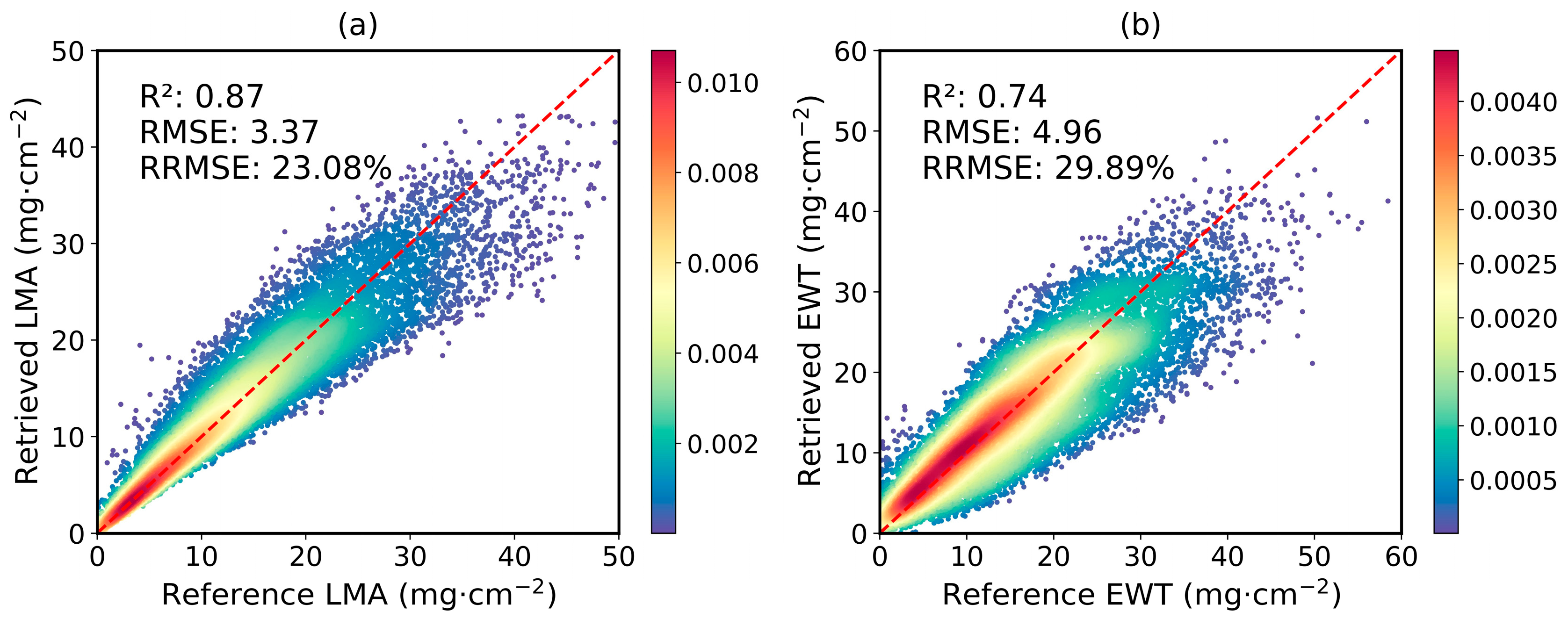
After selecting the optimal band combinations as input parameters to construct the hybrid inversion model, its performance was evaluated using the testing dataset. The resulting scatter density plots are depicted in Figure 3. The R2 between the retrieved LMA and their corresponding reference values is 0.87, with an RMSE of 3.37 mg·cm−2 and an RRMSE of 23.08%. Similarly, for the EWT, the R2 is 0.74, with an RMSE of 4.96 mg·cm−2 and an RRMSE of 29.89%. These results indicate that the hybrid inversion models achieved a good fit with the simulated dataset, demonstrating high predictive accuracy.

3.2. Assessment on Estimates of LMA and EWT

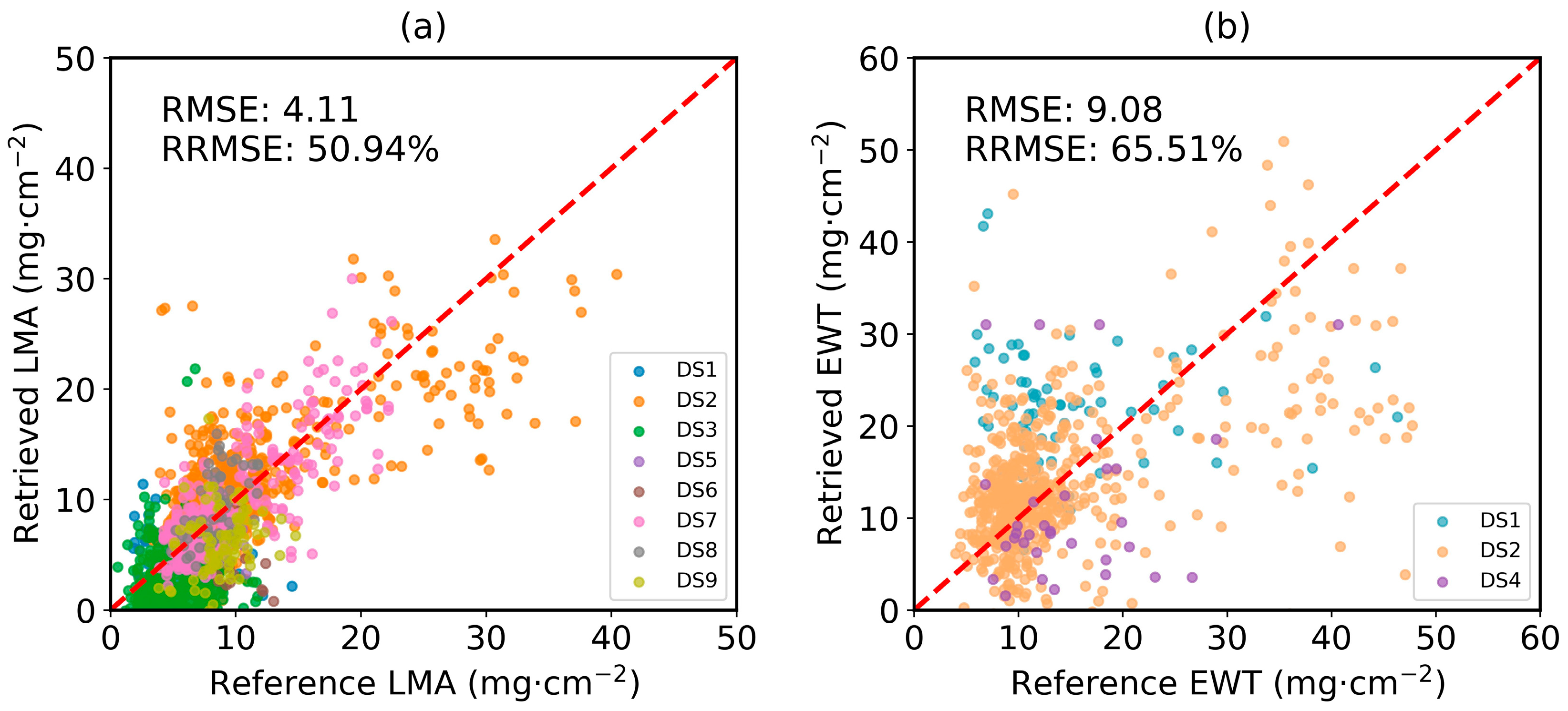
The multi-source field measured dataset, collated from the EcoSIS database, was utilized as an independent validation for the inversion of LMA and EWT. The RMSE between the reference and inverted values for LMA is 4.11 mg·cm−2 (Figure 4a); for the EWT, it is 9.08 mg·cm−2 (Figure 4b). The RRMSE values for the LMA and EWT are 50.94% and 65.51%, respectively. The eight collected datasets contain measurements of the LMA, with the majority of LMA values clustered between 0 and 15 mg·cm−2. Within this range, there is a strong correlation between the inversion values and the reference values, resembling the validation results obtained from testing datasets. However, for a minority of vegetation with higher LMA values, the inversion model demonstrates some degree of underestimation. The EWT inversion model’s performance is relatively poorer than that of the LMA. In DS1, there is a slight overestimation in the inversion EWT values.
The reflectance values of feature bands from PRISMA and EnMAP images were selected and input into hybrid inversion models to derive the LMA and EWT values. The overlapping areas of the two images were then extracted and compared.
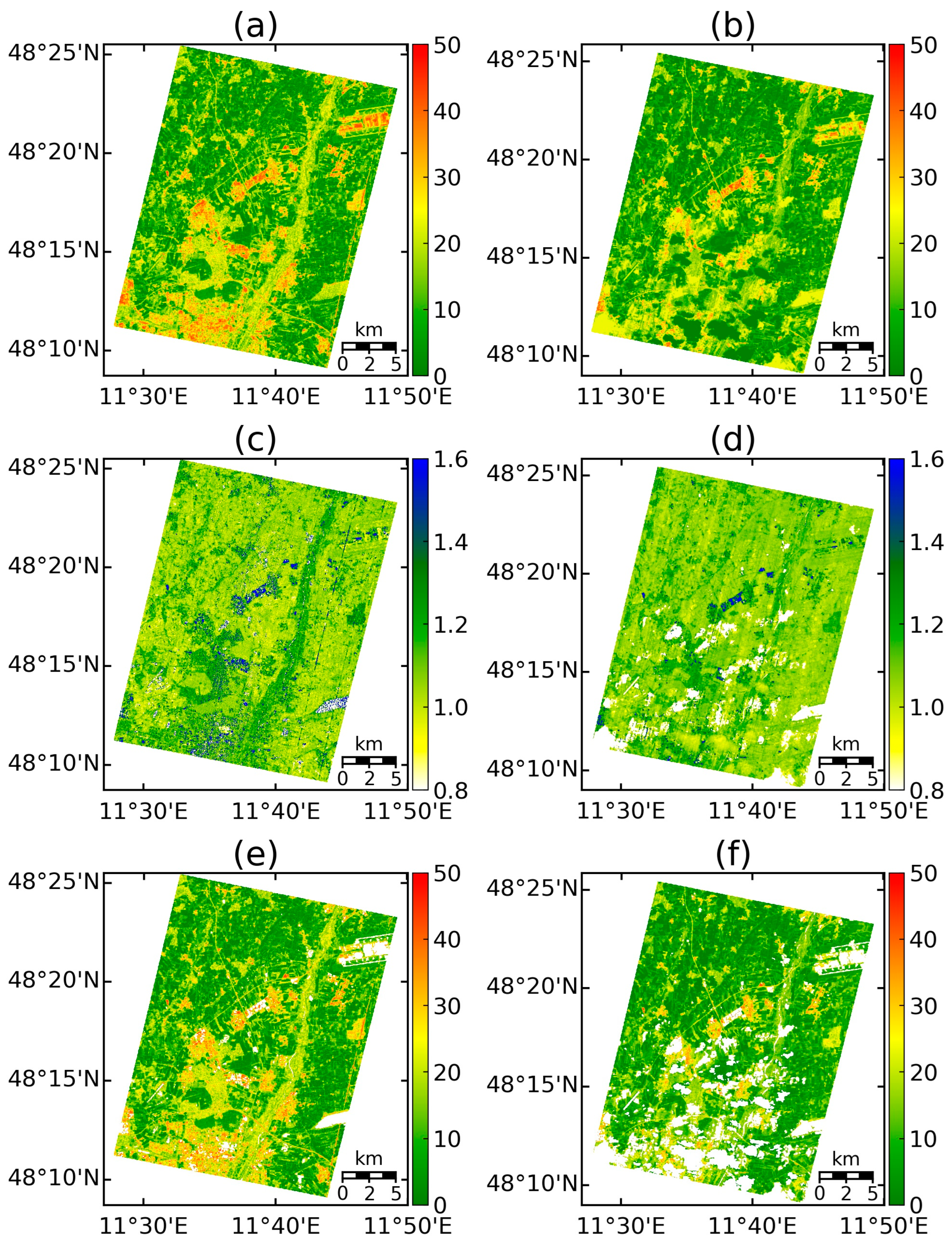
The retrieved LMA values for PRISMA and EnMAP are shown in Figure 5a and Figure 5b, respectively. It is seen that the retrieved LMA has similar spatial distributions for PRISAM and EnMAP, except in the lower right region, where the EnMAP image is contaminated by clouds. The corresponding ARDSI2200,1640,2240,1720 images for PRISMA and EnMAP are plotted in Figure 5c and Figure 5d, respectively. The figures show that the retrieved LMA has a similar pattern to this index that is associated with LMA. However, it is noticed that both the retrieved LMA and the ARDSI2200,1640,2240,1720 exhibit some anomalous high values over the non-vegetated areas, such as the Munich International Airport (upper right of the image). The mapped LMA images were further processed, and the values where the corresponding Normalized Difference Vegetation Index (NDVI) was lower than 0.1 were masked. The results with the non-vegetated areas masked are illustrated in Figure 5e and Figure 5f for PRISMA and EnMAP, respectively, and they show that most of the abnormal values were from the non-vegetated areas.
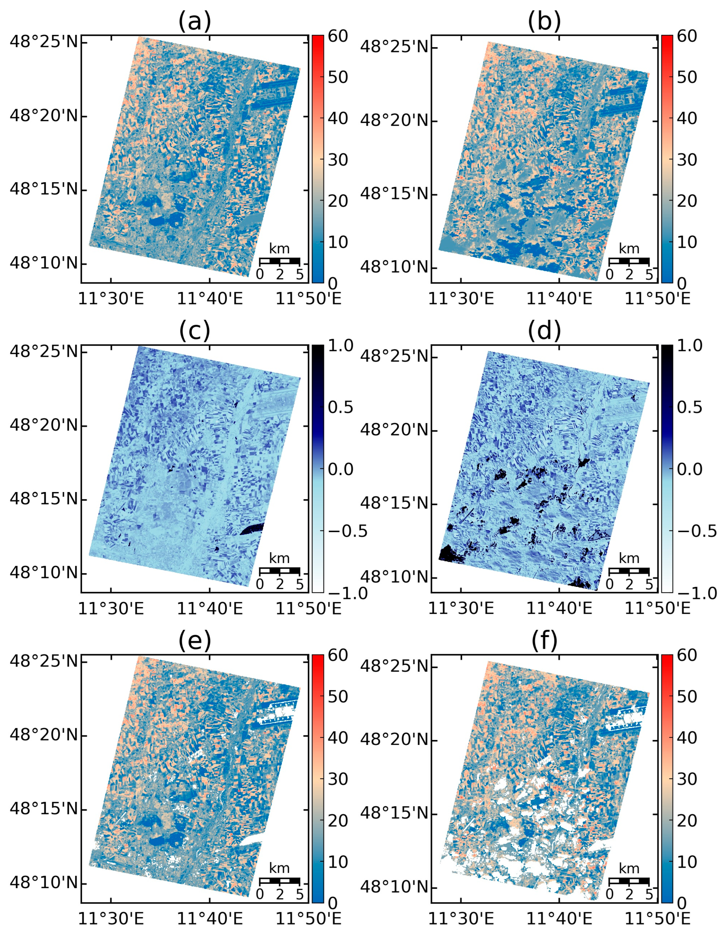
The comparison of the EWT is shown in Figure 6. Figure 6a and Figure 6c are the mapped EWT and the corresponding NDWI for PRISMA, while Figure 6b and Figure 6d are the mapped EWT and the corresponding NDWI for EnMAP. The mapped EWT images with non-vegetated areas masked for PRISMA and EnMAP are shown in Figure 6e and Figure 6f, respectively. Figure 6 demonstrates that the retrieved EWT from PRISMA and EnMAP have similar spatial distribution, and the retrieved EWT has consistent trends with NDWI, supporting the rationality of the retrieved results. In contrast to LMA, retrieved EWT presents low values over non-vegetated areas, indicating the practicability of the hybrid EWT inversion model.
The cross-validation of remote sensing products is an indirect validation method that harmonizes different products with similar temporal characteristics into a consistent projection coordinate system and spatial resolution, assessing the effectiveness of products through intercomparisons [62]. The PRISMA and EnMAP images underwent georeferencing, followed by cloud removal and the identification of vegetation-covered areas (NDVI ≥ 0.1). Then, the LMA and EWT values were extracted for each overlapping pixel from the processed images, and a comparative analysis was conducted to further support the validation process. The comparisons of the LMA and EWT are shown in Figure 7a and Figure 7b, respectively. The results present an RMSE of 5.78 mg·cm⁻² and an RRMSE of 51.63% between the LMA values obtained from the two images. For the EWT, the RMSE was 6.84 mg·cm⁻², with an RRMSE of 41.24%. In the low-value region, the LMA is characterized by dense clustering and exhibits a certain degree of correlation, with minimal variability. In contrast, the distribution in the high-value region is more dispersed, although it generally aligns with the 1:1 fitted line. The EWT values between the two images are comparable, with the overall distribution concentrated near the 1:1 line. The large volume of data results in numerous discrete points in the scatter plots. Overall, the cross-validation results underscore the robustness and consistency of the model across different remote sensing datasets.

4. Discussion

4.1. Limitation of Field Datasets and Hyvrid Inverion Models

The field measurement datasets utilized in this study were collected from multiple locations and diverse ecosystems. The validation results from various datasets demonstrated the strong transferability of the inversion model. The LMA inversion model’s good performance on field datasets could stem from the diversity of the dataset, which provided ample sample support.
Despite having been sourced from the EcoSIS database, the downloaded field datasets might have still contained uncertainties. Initially, the measurement methods and units employed across various datasets were not standardized, necessitating further consolidation and harmonization to ensure usability. Moreover, the majority of datasets did not explicitly specify whether stem measurements were included in the measurement. The radiative transfer model was built upon leaf LMA and EWT, and the values obtained from the inversion model solely represented the biochemical content of the leaves. The datasets did not explicitly elucidate the measurement methods, which could also introduce errors in the evaluation. Moreover, various sources of uncertainty during the measurement process of EWT and LMA could lead to errors. For instance, similar optical properties, and imperfect circular sampling result in leaf disc area loss, water loss during leaf optical measurements and fresh leaf weighing, as well as in moisture absorption during the drying and weighing processes. During leaf weighing, fluctuations in environmental conditions might lead to instability in measurement results. Ideally, field data from various vegetation types should be obtained and incorporated into the model’s training and validation processes to create a more robust and versatile model. In the future, there is potential for more measurement datasets to be openly released, driving the further development of inversion models [63].
The neural network is used in this study due to its superior ability to model complex nonlinear relationships, which are essential for accurately retrieving vegetation parameters. The structure of the neural networks has been designed and trained to work for the inversion of LMA and EWT. Other machine-learning methods, such as Gaussian processes, random forests, and support vector machines, can be also used for retrieving leaf traits after proper designing and training. However, they are not tested in this study because the primary objective of this study is to develop proper hybrid models for retrieving LMA and EWT, rather than comparing different machine-learning methods. The developed hybrid inversion models provide reasonable results, though the hybrid LMA inversion model tends to fail over non-vegetated areas. A pre-identification of vegetated and non-vegetated areas (e.g., through vegetation indices) can reduce retrieval uncertainty.

4.2. Estimation of LMA and EWT from Canopy-Scale Reflectance

Since the advent of optical remote sensing, various methods have been developed for retrieving vegetation parameters, with most of these methods applied to conventional multispectral sensors. Numerous studies have exhibited the achievability of retrieving leaf traits from leaf spectra, such as LMA, EWT, Cab, and leaf nitrogen content. At the canopy scale, spectral reflectance is also correlated with vegetation biochemical traits, albeit with slightly lower precision compared to leaf-scale retrievals. The confounding effects arising from canopy structures and variations in solar and viewing angles may diminish the sensitivity of remote sensing spectra to vegetation traits [64]. The LAI markedly influences canopy-scale reflectance [3]. Substantial variations in the LAI may obscure spectral reflectance features related to water [65], thereby complicating EWT inversion [66]. Apart from the overall canopy thickness, the thickness of individual tissues also affects the ability to retrieve the EWT from remote sensing data [35]. All these factors complicate the retrieval of LMA and EWT from canopy-scale observations in contrast to leaf-scale observations. The vegetation canopy radiative transfer model involved certain approximations and simplifications when considering vegetation structure, leading to additional uncertainties in model simulations [60]. More detailed radiative transfer models can better simulate complex interactions, thereby improving the precision of vegetation parameter inversion. In the future, these advanced models will hold significant potential for processing hyperspectral satellite data.

4.3. Challenges and Opportunities in Satellite-Based Vegetation Monitoring

The development of hyperspectral imaging spectrometers has provided more detailed spectral information for quantitative estimation of plant physiological and biochemical traits compared to multispectral sensors. Since 2022, the coexistence of EnMAP and PRISMA satellites has enhanced the availability of hyperspectral data in temporal sequences [44]. Both PRISMA and EnMAP have a spatial resolution of 30 m, with each pixel containing detailed information. Utilizing hyperspectral remote sensing data for vegetation monitoring has deepened our understanding of plant physiological processes and advanced the inversion and mapping of vegetation traits. Moreover, the hybrid inversion models proposed in this study are applicable to various ecological environments, and their integration with hyperspectral remote sensing data could provide insights for informing policy decisions.
The direct validation of remote sensing data inversion results can be achieved by establishing ground plots and sampling point measurements; however, conducting ground validation at large scales poses certain challenges. Collecting extensive field data requires considerable resources and time, making it challenging to measure vegetation traits comprehensively at large scales. By applying the inversion model to PRISMA and EnMAP images, the distribution of LMA and EWT in the study area was depicted on maps, providing a visual representation of vegetation traits. Although there were no available on-site field datasets for validation during image acquisition, it was still possible to explain the verifiability of the inversion results. There was a certain correlation between the spatial arrangement of inversion variables in the study area and the distribution of land types, as well as spatial consistency with the distribution of vegetation indices. This result served as an indirect validation of the model’s accuracy. Additionally, the cross-validation results of inversion values from two satellite images also helped explain the model’s verifiability, providing additional evidence for the accuracy of the model.

5. Conclusions

This study demonstrated the feasibility of utilizing hybrid inversion models to retrieve LMA and EWT from hyperspectral imagery. By employing a combined inversion approach integrating the PROSAIL radiative transfer model and neural networks, the advantages of both were fully utilized, ensuring the hybrid model’s capability for precise prediction and rapid training. The employment of PROSAIL for simulating canopy reflectance facilitated the integration of vegetation variations across diverse spatiotemporal contexts into the training process, thereby establishing an inversion model with greater universality and transferability. Independent validation using multiple field-measured datasets demonstrated the good accuracy of the inversion model, confirming its potential for directly retrieving vegetation LMA and EWT values from canopy-scale reflectance. To further assess the applicability of the hybrid model, it was applied to PRISMA and EnMAP imagery, resulting in consistent landscape trait maps and achieving high precision in cross-validation results. This provided a pathway for robust vegetation parameter inversion across broad spatial extents.

Author Contributions

Conceptualization, H.S. and X.Y.; methodology, X.Y. and H.S.; software, X.Y.; writing—original draft preparation, X.Y.; writing—review and editing, H.S., X.Y., and Z.X.; funding acquisition, H.S. and Z.X. All authors have read and agreed to the published version of the manuscript.

Funding

This work was financially supported by the National Natural Science Foundation of China (grant number 42201343), the Fundamental Research Funds for the Central Universities (grant number SWU-KQ22055), the Special Fund for Youth Team of Southwest University (grant number SWU-XJLJ202305), and the National Natural Science Foundation of China (grant number 42471350).

Data Availability Statement

The original contributions presented in this study are included in the article. Further inquiries can be directed to the corresponding author.

Acknowledgments

The authors want to thank the editor and the anonymous reviewers for providing insightful comments and suggestions.

Conflicts of Interest

The authors declare no conflicts of interest.

References

  1. Yi, Q.; Wang, F.; Bao, A.; Jiapaer, G. Leaf and canopy water content estimation in cotton using hyperspectral indices and radiative transfer models. Int. J. Appl. Earth Obs. Geoinf. 2014, 33, 67–75. [Google Scholar] [CrossRef]
  2. Lavorel, S.; Garnier, E. Predicting changes in community composition and ecosystem functioning from plant traits: Revisiting the Holy Grail. Funct. Ecol. 2002, 16, 545–556. [Google Scholar] [CrossRef]
  3. Zarco-Tejada, P.J.; Rueda, C.A.; Ustin, S.L. Water content estimation in vegetation with MODIS reflectance data and model inversion methods. Remote Sens. Environ. 2003, 85, 109–124. [Google Scholar] [CrossRef]
  4. Féret, J.-B.; François, C.; Gitelson, A.; Asner, G.P.; Barry, K.M.; Panigada, C.; Richardson, A.D.; Jacquemoud, S. Optimizing spectral indices and chemometric analysis of leaf chemical properties using radiative transfer modeling. Remote Sens. Environ. 2011, 115, 2742–2750. [Google Scholar] [CrossRef]
  5. Asner, G.P.; Martin, R.E.; Carranza-Jiménez, L.; Sinca, F.; Tupayachi, R.; Anderson, C.B.; Martinez, P. Functional and biological diversity of foliar spectra in tree canopies throughout the Andes to Amazon region. New Phytol. 2014, 204, 127–139. [Google Scholar] [CrossRef] [PubMed]
  6. Pereira, H.M.; Ferrier, S.; Walters, M.; Geller, G.N.; Jongman, R.H.G.; Scholes, R.J.; Bruford, M.W.; Brummitt, N.; Butchart, S.H.M.; Cardoso, A.C.; et al. Essential Biodiversity Variables. Science 2013, 339, 277–278. [Google Scholar] [CrossRef]
  7. Puglielli, G.; Crescente, M.F.; Frattaroli, A.R.; Gratani, L. Leaf mass per area (LMA) as a possible predictor of adaptive strategies in two species of Sesleria (Poaceae): Analysis of morphological, anatomical and physiological leaf traits. Ann. Bot. Fenn. 2015, 52, 135–143. [Google Scholar] [CrossRef]
  8. Niinemets, Ü.; Kull, O.; Tenhunen, J.D. Variability in Leaf Morphology and Chemical Composition as a Function of Canopy Light Environment in Coexisting Deciduous Trees. Int. J. Plant Sci. 1999, 160, 837–848. [Google Scholar] [CrossRef]
  9. Asner, G.P.; Martin, R.E.; Tupayachi, R.; Emerson, R.; Martinez, P.; Sinca, F.; Powell, G.V.N.; Wright, S.J.; Lugo, A.E. Taxonomy and remote sensing of leaf mass per area (LMA) in humid tropical forests. Ecol. Appl. 2011, 21, 85–98. [Google Scholar] [CrossRef]
  10. Wright, I.J.; Reich, P.B.; Westoby, M.; Ackerly, D.D.; Baruch, Z.; Bongers, F.; Cavender-Bares, J.; Chapin, T.; Cornelissen, J.H.C.; Diemer, M.; et al. The worldwide leaf economics spectrum. Nature 2004, 428, 821–827. [Google Scholar] [CrossRef]
  11. Osnas, J.L.D.; Lichstein, J.W.; Reich, P.B.; Pacala, S.W. Global Leaf Trait Relationships: Mass, Area, and the Leaf Economics Spectrum. Science 2013, 340, 741–744. [Google Scholar] [CrossRef] [PubMed]
  12. Gara, T.W.; Rahimzadeh-Bajgiran, P.; Darvishzadeh, R. Forest Leaf Mass per Area (LMA) through the Eye of Optical Remote Sensing: A Review and Future Outlook. Remote Sen. 2021, 13, 3352. [Google Scholar] [CrossRef]
  13. Reich, P.B.; Walters, M.B.; Ellsworth, D.S.; Vose, J.M.; Volin, J.C.; Gresham, C.; Bowman, W.D. Relationships of leaf dark respiration to leaf nitrogen, specific leaf area and leaf life-span: A test across biomes and functional groups. Oecologia 1998, 114, 471–482. [Google Scholar] [CrossRef] [PubMed]
  14. Weng, E.; Farrior, C.E.; Dybzinski, R.; Pacala, S.W. Predicting Vegetation type through physiological and environmental interactions with leaf traits: Evergreen and deciduous forests in an earth system modeling framework. Glob. Change Biol. 2017, 23, 2482–2498. [Google Scholar] [CrossRef] [PubMed]
  15. Mcgill, B.; Enquist, B.; Weiher, E.; Westoby, M. Rebuilding community ecology from functional traits. Trends Ecol. Evol. 2006, 21, 178–185. [Google Scholar] [CrossRef]
  16. Schimel, D.; Pavlick, R.; Fisher, J.B.; Asner, G.P.; Saatchi, S.; Townsend, P.; Miller, C.; Frankenberg, C.; Hibbard, K.; Cox, P. Observing terrestrial ecosystems and the carbon cycle from space. Glob. Change Biol. 2015, 21, 1762–1776. [Google Scholar] [CrossRef]
  17. Poorter, H.; Niinemets, Ü.; Poorter, L.; Wright, I.J.; Villar, R. Causes and consequences of variation in leaf mass per area (LMA): A meta-analysis. New Phytol. 2009, 182, 565–588. [Google Scholar] [CrossRef]
  18. Raymond Hunt, E.; Wang, L.; Qu, J.J.; Hao, X. Remote Sensing of fuel moisture content from canopy water indices and normalized dry matter index. J. Appl. Remote Sens. 2012, 6, 061705. [Google Scholar] [CrossRef]
  19. Wang, L.; Hunt, E.R.; Qu, J.J.; Hao, X.; Daughtry, C.S.T. Remote sensing of fuel moisture content from ratios of narrow-band vegetation water and dry-matter indices. Remote Sens. Environ. 2013, 129, 103–110. [Google Scholar] [CrossRef]
  20. Zhang, C.; Pattey, E.; Liu, J.; Cai, H.; Shang, J.; Dong, T. Retrieving Leaf and Canopy Water Content of Winter Wheat Using Vegetation Water Indices. IEEE J. Sel. Top. Appl. Earth Obs. Remote Sens. 2018, 11, 112–126. [Google Scholar] [CrossRef]
  21. Chen, Y.; Sun, J.; Wang, L.; Shi, S.; Qiu, F.; Gong, W.; Wang, S.; Tagesson, T. Exploring the potential of transmittance vegetation indices for leaf functional traits retrieval. GISci. Remote Sens. 2023, 60, 2168410. [Google Scholar] [CrossRef]
  22. Peñuelas, J.; Filella, I.; Biel, C.; Serrano, L.; Savé, R. The reflectance at the 950–970 nm region as an indicator of plant water status. Int. J. Remote Sens. 1993, 14, 1887–1905. [Google Scholar] [CrossRef]
  23. Claudio, H.; Cheng, Y.; Fuentes, D.; Gamon, J.; Luo, H.; Oechel, W.; Qiu, H.; Rahman, A.; Sims, D. Monitoring drought effects on vegetation water content and fluxes in chaparral with the 970 nm water band index. Remote Sens. Environ. 2006, 103, 304–311. [Google Scholar] [CrossRef]
  24. Chuvieco, E.; Cocero, D.; Riaño, D.; Martin, P.; Martínez-Vega, J.; De La Riva, J.; Pérez, F. Combining NDVI and surface temperature for the estimation of live fuel moisture content in forest fire danger rating. Remote Sens. Environ. 2004, 92, 322–331. [Google Scholar] [CrossRef]
  25. Verrelst, J.; Malenovský, Z.; Van Der Tol, C.; Camps-Valls, G.; Gastellu-Etchegorry, J.-P.; Lewis, P.; North, P.; Moreno, J. Quantifying Vegetation Biophysical Variables from Imaging Spectroscopy Data: A Review on Retrieval Methods. Surv. Geophys. 2019, 40, 589–629. [Google Scholar] [CrossRef]
  26. Asner, G.P.; Martin, R.E. Airborne spectranomics: Mapping canopy chemical and taxonomic diversity in tropical forests. Front. Ecol. Environ. 2009, 7, 269–276. [Google Scholar] [CrossRef]
  27. Houborg, R.; Boegh, E. Mapping leaf chlorophyll and leaf area index using inverse and forward canopy reflectance modeling and SPOT reflectance data. Remote Sens. Environ. 2008, 112, 186–202. [Google Scholar] [CrossRef]
  28. Weiss, M.; Jacob, F.; Duveiller, G. Remote sensing for agricultural applications: A meta-review. Remote Sens. Environ. 2020, 236, 111402. [Google Scholar] [CrossRef]
  29. Féret, J.-B.; Le Maire, G.; Jay, S.; Berveiller, D.; Bendoula, R.; Hmimina, G.; Cheraiet, A.; Oliveira, J.C.; Ponzoni, F.J.; Solanki, T.; et al. Estimating leaf mass per area and equivalent water thickness based on leaf optical properties: Potential and limitations of physical modeling and machine learning. Remote Sens. Environ. 2019, 231, 110959. [Google Scholar] [CrossRef]
  30. Wang, L.; Qu, J.J.; Hao, X.; Hunt, E.R. Estimating dry matter content from spectral reflectance for green leaves of different species. Int. J. Remote Sens. 2011, 32, 7097–7109. [Google Scholar] [CrossRef]
  31. Cheng, T.; Rivard, B.; Sánchez-Azofeifa, A.G.; Féret, J.-B.; Jacquemoud, S.; Ustin, S.L. Deriving leaf mass per area (LMA) from foliar reflectance across a variety of plant species using continuous wavelet analysis. ISPRS J. Photogramm. Remote Sens. 2014, 87, 28–38. [Google Scholar] [CrossRef]
  32. Ali, A.M.; Darvishzadeh, R.; Skidmore, A.K.; Duren, I.V. Effects of Canopy Structural Variables on Retrieval of Leaf Dry Matter Content and Specific Leaf Area From Remotely Sensed Data. IEEE J. Sel. Top. Appl. Earth Obs. Remote Sens. 2016, 9, 898–909. [Google Scholar] [CrossRef]
  33. Wan, L.; Tang, Z.; Zhang, J.; Chen, S.; Zhou, W.; Cen, H. Upscaling from Leaf to canopy: Improved spectral indices for leaf biochemical traits estimation by minimizing the difference between leaf adaxial and abaxial surfaces. Field Crops Res. 2021, 274, 108330. [Google Scholar] [CrossRef]
  34. Gao, B. NDWI—A normalized difference water index for remote sensing of vegetation liquid water from space. Remote Sens. Environ. 1996, 58, 257–266. [Google Scholar] [CrossRef]
  35. Sims, D.A.; Gamon, J.A. Estimation of vegetation water content and photosynthetic tissue area from spectral reflectance: A comparison of indices based on liquid water and chlorophyll absorption features. Remote Sens. Environ. 2003, 84, 526–537. [Google Scholar] [CrossRef]
  36. Lemaire, G.; Francois, C.; Soudani, K.; Berveiller, D.; Pontailler, J.; Breda, N.; Genet, H.; Davi, H.; Dufrene, E. Calibration and validation of hyperspectral indices for the estimation of broadleaved forest leaf chlorophyll content, leaf mass per area, leaf area index and leaf canopy biomass. Remote Sens. Environ. 2008, 112, 3846–3864. [Google Scholar] [CrossRef]
  37. Penuelas, J.; Pinol, J.; Ogaya, R.; Filella, I. Estimation of plant water concentration by the reflectance Water Index WI (R900/R970). Int. J. Remote Sens. 1997, 18, 2869–2875. [Google Scholar] [CrossRef]
  38. Hauser, L.T.; Féret, J.-B.; An Binh, N.; Van Der Windt, N.; Sil, Â.F.; Timmermans, J.; Soudzilovskaia, N.A.; Van Bodegom, P.M. Towards scalable estimation of plant functional diversity from Sentinel-2: In-situ validation in a heterogeneous (semi-)natural landscape. Remote Sens. Environ. 2021, 262, 112505. [Google Scholar] [CrossRef]
  39. Campos-Taberner, M.; Moreno-Martínez, Á.; García-Haro, F.; Camps-Valls, G.; Robinson, N.; Kattge, J.; Running, S. Global Estimation of Biophysical Variables from Google Earth Engine Platform. Remote Sens. 2018, 10, 1167. [Google Scholar] [CrossRef]
  40. Yang, B.; Lin, H.; He, Y. Data-Driven Methods for the Estimation of Leaf Water and Dry Matter Content: Performances, Potential and Limitations. Sensors 2020, 20, 5394. [Google Scholar] [CrossRef]
  41. Zhang, Y.; Yang, J.; Liu, X.; Du, L.; Shi, S.; Sun, J.; Chen, B. Estimation of Multi-Species Leaf Area Index Based on Chinese GF-1 Satellite Data Using Look-Up Table and Gaussian Process Regression Methods. Sensors 2020, 20, 2460. [Google Scholar] [CrossRef] [PubMed]
  42. Homolová, L.; Malenovský, Z.; Clevers, J.G.P.W.; García-Santos, G.; Schaepman, M.E. Review of optical-based remote sensing for plant trait mapping. Ecol. Complex. 2013, 15, 1–16. [Google Scholar] [CrossRef]
  43. Goetz, A.F.H. Three Decades of hyperspectral remote sensing of the earth: A personal view. Remote Sens. Environ. 2009, 113, S5–S16. [Google Scholar] [CrossRef]
  44. Verrelst, J.; Rivera-Caicedo, J.P.; Reyes-Muñoz, P.; Morata, M.; Amin, E.; Tagliabue, G.; Panigada, C.; Hank, T.; Berger, K. Mapping landscape canopy nitrogen content from space using PRISMA data. ISPRS J. Photogramm. Remote Sens. 2021, 178, 382–395. [Google Scholar] [CrossRef]
  45. Pascual-Venteo, A.B.; Garcia, J.L.; Berger, K.; Estévez, J.; Vicent, J.; Pérez-Suay, A.; Van Wittenberghe, S.; Verrelst, J. Gaussian Process Regression Hybrid Models for the Top-of-Atmosphere Retrieval of Vegetation Traits Applied to PRISMA and EnMAP Imagery. Remote Sens. 2024, 16, 1211. [Google Scholar] [CrossRef]
  46. Guanter, L.; Kaufmann, H.; Segl, K.; Foerster, S.; Rogass, C.; Chabrillat, S.; Kuester, T.; Hollstein, A.; Rossner, G.; Chlebek, C.; et al. The EnMAP Spaceborne Imaging Spectroscopy Mission for Earth Observation. Remote Sens. 2015, 7, 8830–8857. [Google Scholar] [CrossRef]
  47. Labate, D.; Ceccherini, M.; Cisbani, A.; De Cosmo, V.; Galeazzi, C.; Giunti, L.; Melozzi, M.; Pieraccini, S.; Stagi, M. The PRISMA payload optomechanical design, a high performance instrument for a new hyperspectral mission. Acta Astronaut. 2009, 65, 1429–1436. [Google Scholar] [CrossRef]
  48. Van Cleemput, E.; Helsen, K.; Feilhauer, H.; Honnay, H.; Somers, B. Canopy Spectra of Individual Herbaceous Species Measured on Black Table. From the Ecological Spectral Information System (EcoSIS). Available online: http://ecosis.org/package/canopy-spectra-of-individual-herbaceous-species-measured-on-black-table (accessed on 17 October 2024). [CrossRef]
  49. Wang, Z. Canopy Spectra to Map Foliar Functional Traits over NEON Domains in Eastern United States. The Ecological Spectral Information System (EcoSIS). Available online: http://ecosis.org/package/canopy-spectra-to-map-foliar-functional-traits-over-neon-domains-in-eastern-united-states (accessed on 17 October 2024). [CrossRef]
  50. Kattenborn, T.; Schiefer, F.; Schmidtlein, S. Canopy Reflectance Plant Functional Gradient IFGG/KIT. The Ecological Spectral Information System (EcoSIS). Available online: http://ecosis.org/package/canopy-reflectance-plant-functional-gradient-ifgg-kit (accessed on 17 October 2024). [CrossRef]
  51. Shawn, P.S.; Daryl, Y.; Ran, M.; Andrew, M.; Wouter, H.; Daniel, H.; Kim, E. NGEE Arctic 2017 Canopy Spectral Reflectance Seward Peninsula Alaska. The Ecological Spectral Information System (EcoSIS). Available online: http://ecosis.org/package/ngee-arctic-2017-canopy-spectral-reflectance-seward-peninsula-alaska (accessed on 17 October 2024).
  52. Shawn, P.S.; Alistair, R.; Kim, E. NGEE Arctic 2016 Averaged Canopy Spectral Reflectance Seward Peninsula Alaska. The Ecological Spectral Information System (EcoSIS). Available online: http://ecosis.org/package/ngee-arctic-2016-averaged-canopy-spectral-reflectance-seward-peninsula-alaska (accessed on 17 October 2024).
  53. Shawn, P.S.; Daryl, Y.; Ran, M.; Andrew, M.; Wouter, H.; Daniel, H.; Kim, E. NGEE Arctic 2018 Canopy Spectral Reflectance Kougarok Watershed Seward Peninsula Alaska. The Ecological Spectral Information System (EcoSIS). Available online: http://ecosis.org/package/ngee-arctic-2018-canopy-spectral-reflectance-kougarok-watershed-seward-peninsula-alaska (accessed on 17 October 2024).
  54. Singh, A. Mapping Canopy Foliar Chemical and Morphological Traits Using Imaging Spectroscopy. The Ecological Spectral Information System (EcoSIS). Available online: http://ecosis.org/package/mapping-canopy-foliar-chemical-and-morphological-traits-using-imaging-spectroscopy (accessed on 17 October 2024).
  55. Chlus, A. 3D LMA Canopy Level Spectra. The Ecological Spectral Information System (EcoSIS). Available online: http://ecosis.org/package/3d-lma-canopy-level-spectra (accessed on 17 October 2024).
  56. Philip, A.T.; Chlus, A. Seasonal Canopy Spectra and Traits, Blackhawk Island, WI. The Ecological Spectral Information System (EcoSIS). Available online: http://ecosis.org/package/seasonal-canopy-spectra-and-traits--blackhawk-island--wi (accessed on 17 October 2024).
  57. Féret, J.-B.; Gitelson, A.A.; Noble, S.D.; Jacquemoud, S. PROSPECT-D: Towards modeling leaf optical properties through a complete lifecycle. Remote Sens. Environ. 2017, 193, 204–215. [Google Scholar] [CrossRef]
  58. Verhoef, W. Light Scattering by Leaf Layers with Application to Canopy Reflectance Modeling: The SAIL Model. Remote Sens. Environ. 1984, 16, 125–141. [Google Scholar] [CrossRef]
  59. Jacquemoud, S.; Verhoef, W.; Baret, F.; Bacour, C.; Zarco-Tejada, P.J.; Asner, G.P.; François, C.; Ustin, S.L. PROSPECT+SAIL models: A review of use for vegetation characterization. Remote Sens. Environ. 2009, 113, S56–S66. [Google Scholar] [CrossRef]
  60. Combal, B.; Baret, F.; Weiss, M.; Trubuil, A.; Macé, D.; Pragnère, A.; Myneni, R.; Knyazikhin, Y.; Wang, L. Retrieval of canopy biophysical variables from bidirectional reflectance. Remote Sens. Environ. 2003, 84, 1–15. [Google Scholar] [CrossRef]
  61. Baskiotis, C.; Aval, J.; Bouz, M.E.; Falou, A.A. Selecting Hyperspectral Bands for Leaf Mass Per Area Prediction by Means of Neural Networks. In Proceedings of the IEEE International Symposium on Geoscience and Remote Sensing (IGARSS), Kuala Lumpur, Malaysia, 17–22 July 2022; pp. 1408–1411. [Google Scholar] [CrossRef]
  62. Weiss, M.; Baret, F.; Garrigues, S.; Lacaze, R. LAI and fAPAR CYCLOPES global products derived from VEGETATION. Part 2: Validation and comparison with MODIS collection 4 Products. Remote Sens. Environ. 2007, 110, 317–331. [Google Scholar] [CrossRef]
  63. Cherif, E.; Feilhauer, H.; Berger, K.; Dao, P.D.; Ewald, M.; Hank, T.B.; He, Y.; Kovach, K.R.; Lu, B.; Townsend, P.A.; et al. From spectra to plant functional traits: Transferable multi-trait models from heterogeneous and sparse data. Remote Sens. Environ. 2023, 292, 113580. [Google Scholar] [CrossRef]
  64. Asner, G.; Martin, R. Spectral and chemical analysis of tropical forests: Scaling from leaf to canopy levels. Remote Sens. Environ. 2008, 112, 3958–3970. [Google Scholar] [CrossRef]
  65. Riggs, G.A.; Running, S.W. Detection of canopy water stress in conifers using the airborne imaging spectrometer. Remote Sens. Environ. 1991, 35, 51–68. [Google Scholar] [CrossRef]
  66. Yebra, M.; Dennison, P.E.; Chuvieco, E.; Riaño, D.; Zylstra, P.; Hunt, E.R.; Danson, F.M.; Qi, Y.; Jurdao, S. A global review of remote sensing of live fuel moisture content for fire danger assessment: Moving towards operational products. Remote Sens. Environ. 2013, 136, 455–468. [Google Scholar] [CrossRef]
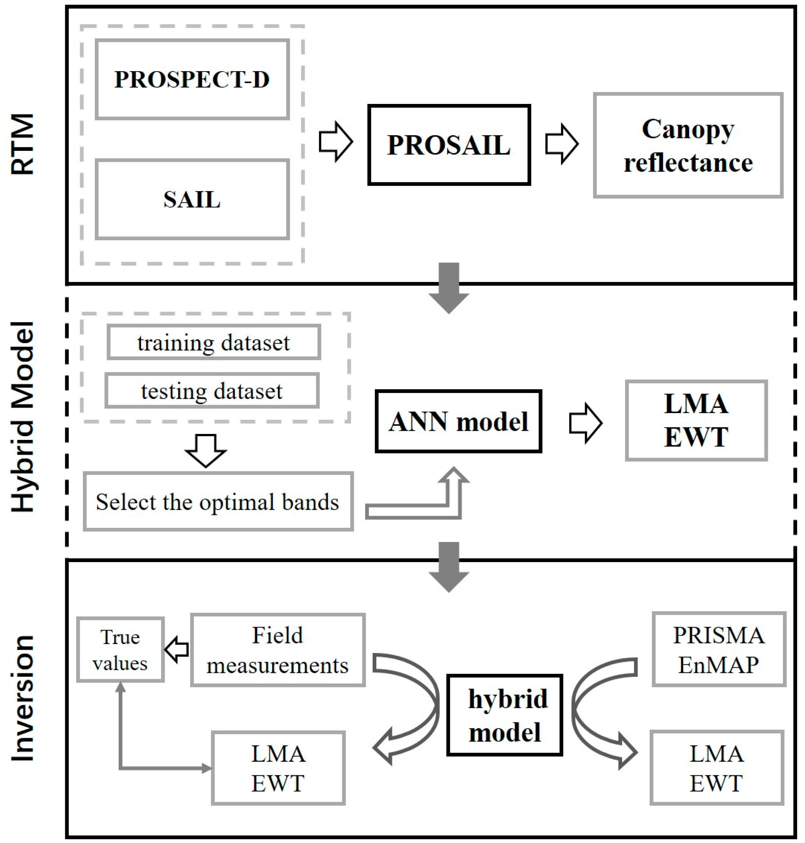
Figure 1. Workflow diagram of the hybrid model combining the radiative transfer model (PROSAIL) and artificial neural network (ANN) for retrieving LMA and EWT.
Remotesensing 16 04064 g001
Figure 2. PRISMA image (lower right) and EnMAP images (upper left) of the study area.
Remotesensing 16 04064 g002
Figure 3. Training accuracy of the hybrid inversion models for (a) LMA and (b) EWT. The red dashed line represents the 1:1 relationship.
Remotesensing 16 04064 g003
Figure 4. Scatter plot of inverted values versus measured values for (a) LMA and (b) EWT. The red dashed line represents the 1:1 relationship.
Remotesensing 16 04064 g004
Figure 5. Mapping of LMA (mg·cm−2) from (a) PRISMA and (b) EnMAP. Mapping of ARDSI2200,1640,2240,1720 from (c) PRISMA and (d) EnMAP. Mapping of LMA (mg·cm−2) from (e) PRISMA and (f) EnMAP, with non-vegetated areas masked.
Remotesensing 16 04064 g005
Figure 6. Mapping of EWT (mg·cm−2) from (a) PRISMA and (b) EnMAP. Mapping of NDWI from (c) PRISMA and (d) EnMAP. Mapping of EWT (mg·cm−2) from (e) PRISMA and (f) EnMAP, with cloud and non-vegetated areas masked.
Remotesensing 16 04064 g006
Figure 7. Cross-validation results of (a) LMA and (b) EWT inversion using PRISMA and EnMAP images. The red dashed line represents the 1:1 relationship.
Remotesensing 16 04064 g007
Table 1. Field datasets utilized in this study and the corresponding LMA (mg·cm−2) and EWT (mg·cm−2). NB: number of bands, NS: number of samples.
DatasetTraitsMinMaxMethodSpectra RangeNBLand CoverNSReference
DS1LMA1.8214.49Proximal350–25002151Grassland73[48]
EWT5.8146.3173
DS2LMA3.3950.71Airborne384–2512426Mix666[49]
EWT3.9780.62648
DS3LMA0.5711.75Proximal400–25002101Grassland582[50]
DS4EWT4.0540.65Proximal350–25002151Tundra43[51]
DS5LMA5.5910.82Proximal350–25002151Tundra18[52]
DS6LMA8.3213.02Proximal350–25002151Shrubland22[53]
DS7LMA3.9222.43Airborne366–2500223Forests304[54]
DS8LMA4.8311.77Airborne405–2445351Forests59[55]
DS9LMA3.8414.77Airborne407–2389187Forests80[56]
Table 2. The range and sampling methods for PROSAIL parameters. STD: standard deviation.
ParameterDescriptionUnitMinMaxMeanSTDDistribution
LMALeaf mass per areamg·cm−20501013Gaussian
EWTLeaf equivalent water thicknessmg·cm−20601511.5Gaussian
NLeaf structure parameter131.51Gaussian
LAILeaf area indexm2·m−217Uniform
ALIAAverage leaf inclination angledegree3070Uniform
PsoilSoil parameter01Uniform
SZASolar zenith angledegree2060Uniform
Table 3. Performance of vegetation index and characteristic wavelength combinations on the inversion of LMA and EWT.
TraitsIndexFormulationR2RMSE (mg·cm−2)
LMAARDSI2200,1640,2240,1720(R2200 − R1640)/(R2240 − R1720)0.675.4
NDMI(R1649 − R1722)/(R1649 + R1722)0.556.3
BandR2300; R1722; R2133; R1649; R1675; R2281; R22600.883.4
BandR2300; R1722; R2133; R1649; R22810.873.4
EWTARDSI1360,1080,1560,1240(R1360 − R1080)/(R1560 − R1240)0.645.7
NDWI(R860 − R1240)/(R860 + R1240)0.467.0
BandR1080; R1240; R15600.745.0
Disclaimer/Publisher’s Note: The statements, opinions and data contained in all publications are solely those of the individual author(s) and contributor(s) and not of MDPI and/or the editor(s). MDPI and/or the editor(s) disclaim responsibility for any injury to people or property resulting from any ideas, methods, instructions or products referred to in the content.