
An Adaptive Offset Tracking Method with SAR Images for Landslide Displacement Monitoring


Abstract
:
1. Introduction
2. Methodology
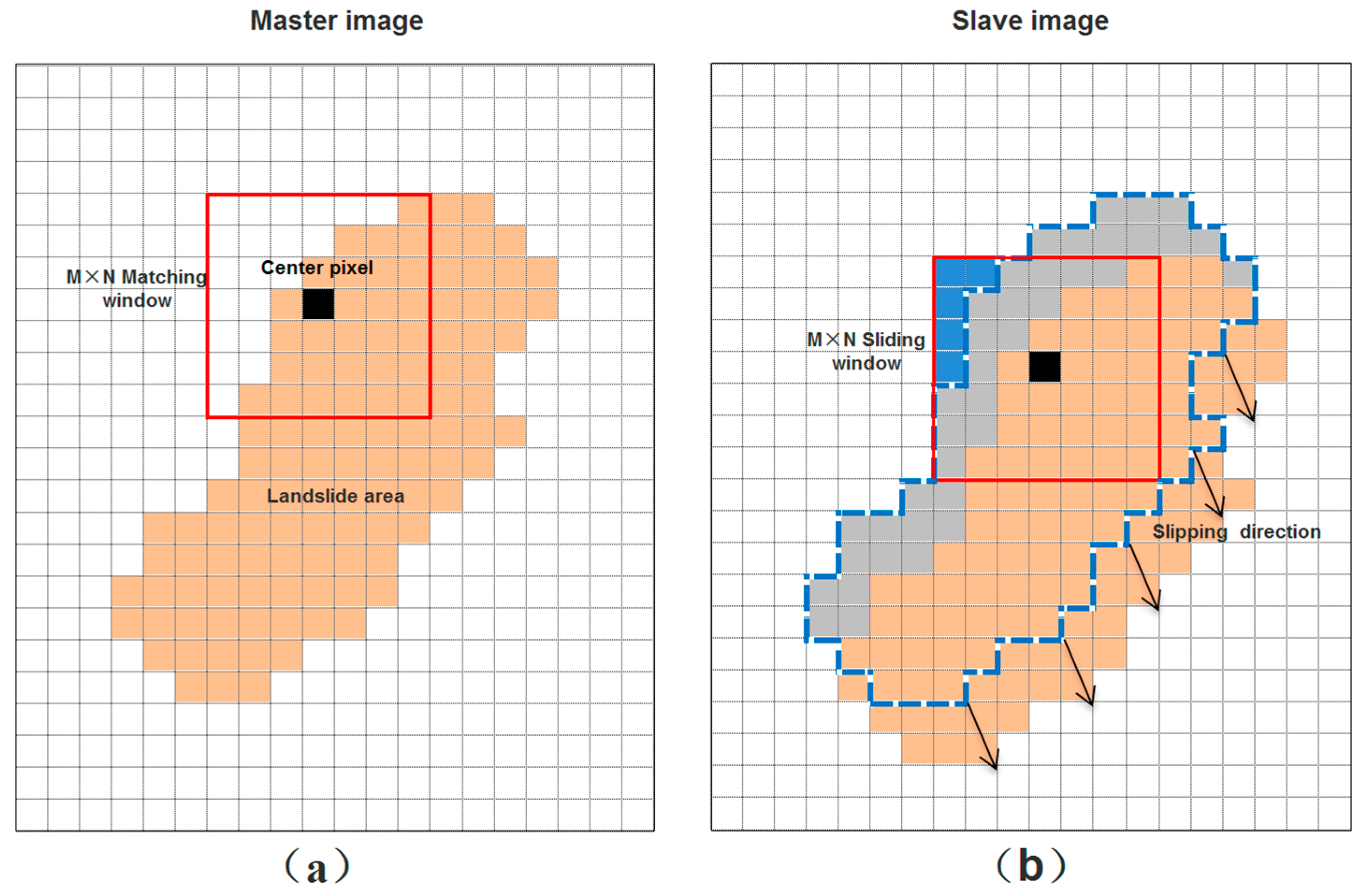
2.1. The Traditional NCC Tracking Method
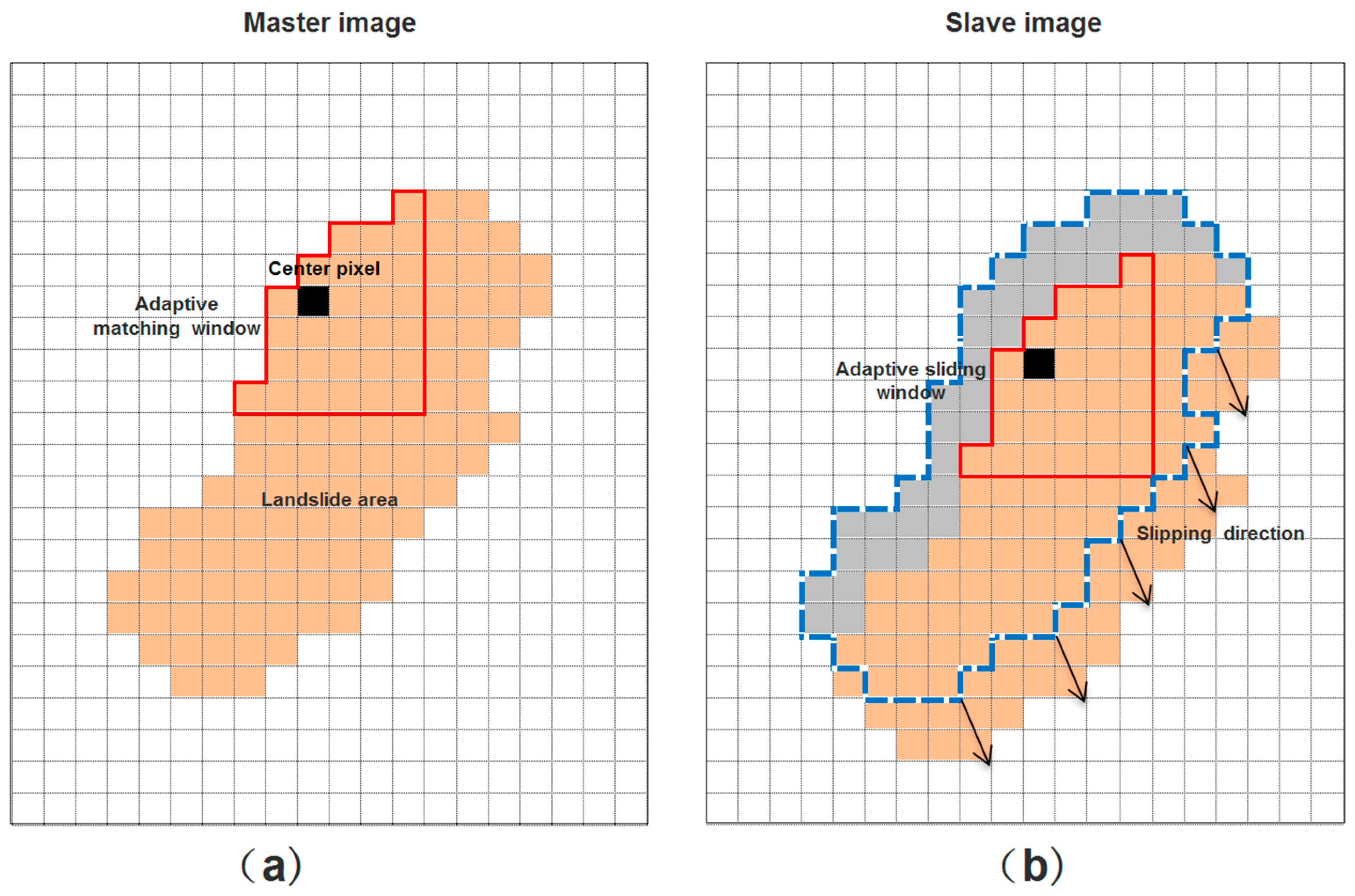
2.2. The Proposed Adaptive Normalized Cross Correlation (ANCC) Method
- (1)
- Making a rough co-registration for master and slave SAR images;
- (2)
- Calculating initial azimuth and range offsets between master and slave SAR images using the traditional NCC method;
- (3)
- Thresholding the azimuth and range offsets and generating two corresponding mask images;
- (4)
- Estimating azimuth and range offsets by using an adaptive window guided by the mask images;
- (5)
- Fitting the orbit offsets function with the pixels from stable areas determined by the above mask results;
- (6)
- Subtracting the fitted orbit offsets and generating azimuth and range displacements by multiplying the corresponding pixel spacing.
3. Study Area and Experimental Results
4. Discussion
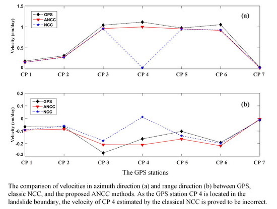
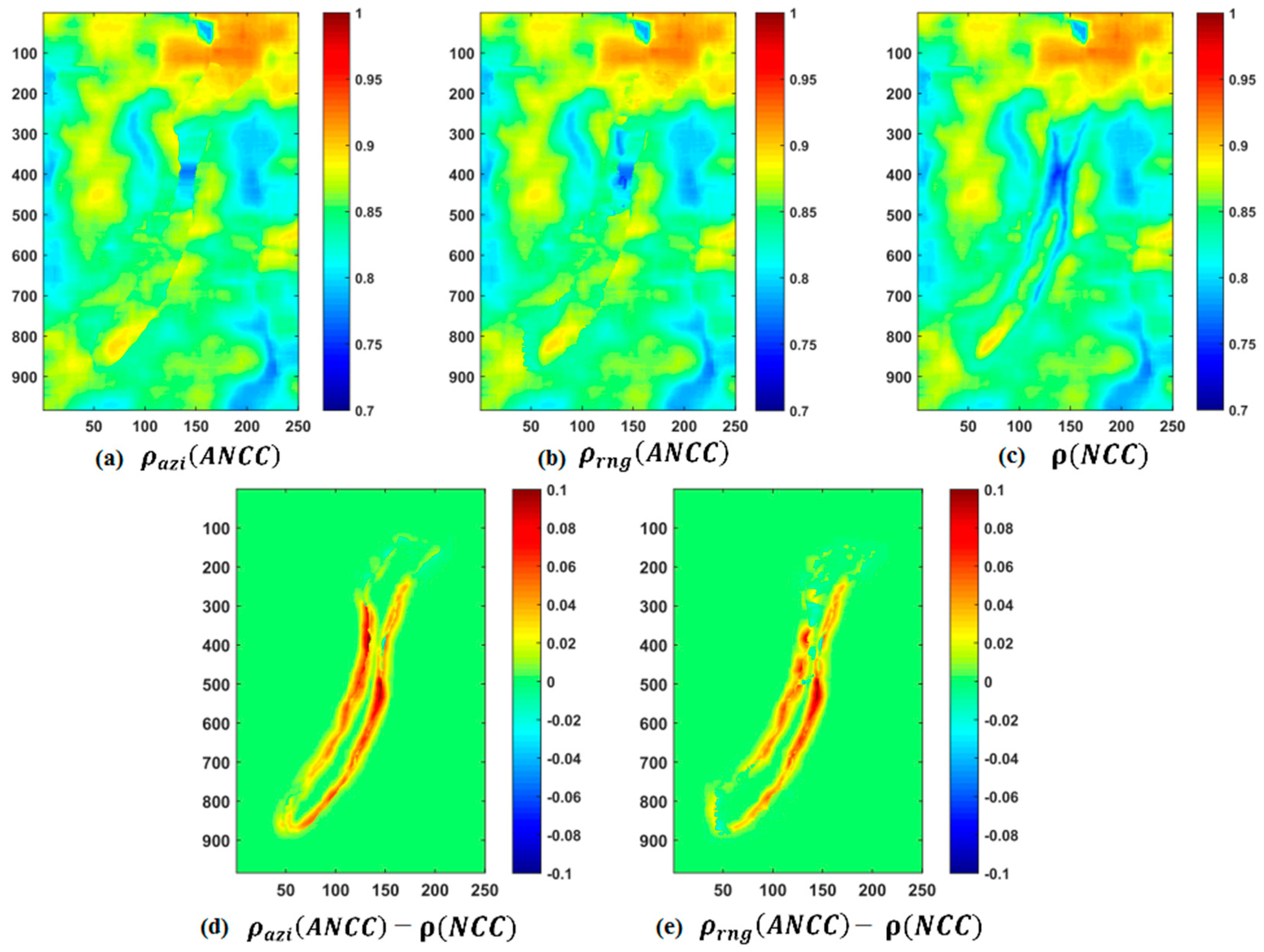
4.1. Accuracy Assessment of the Offsets Estimation
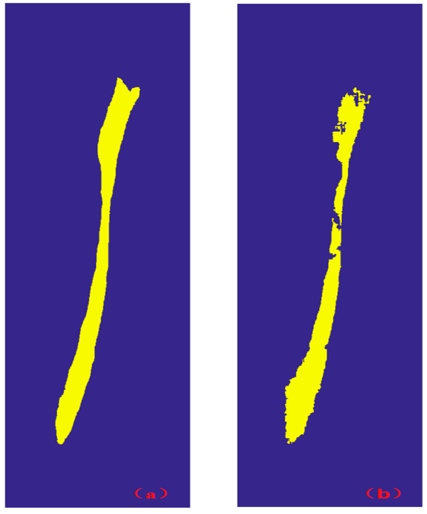
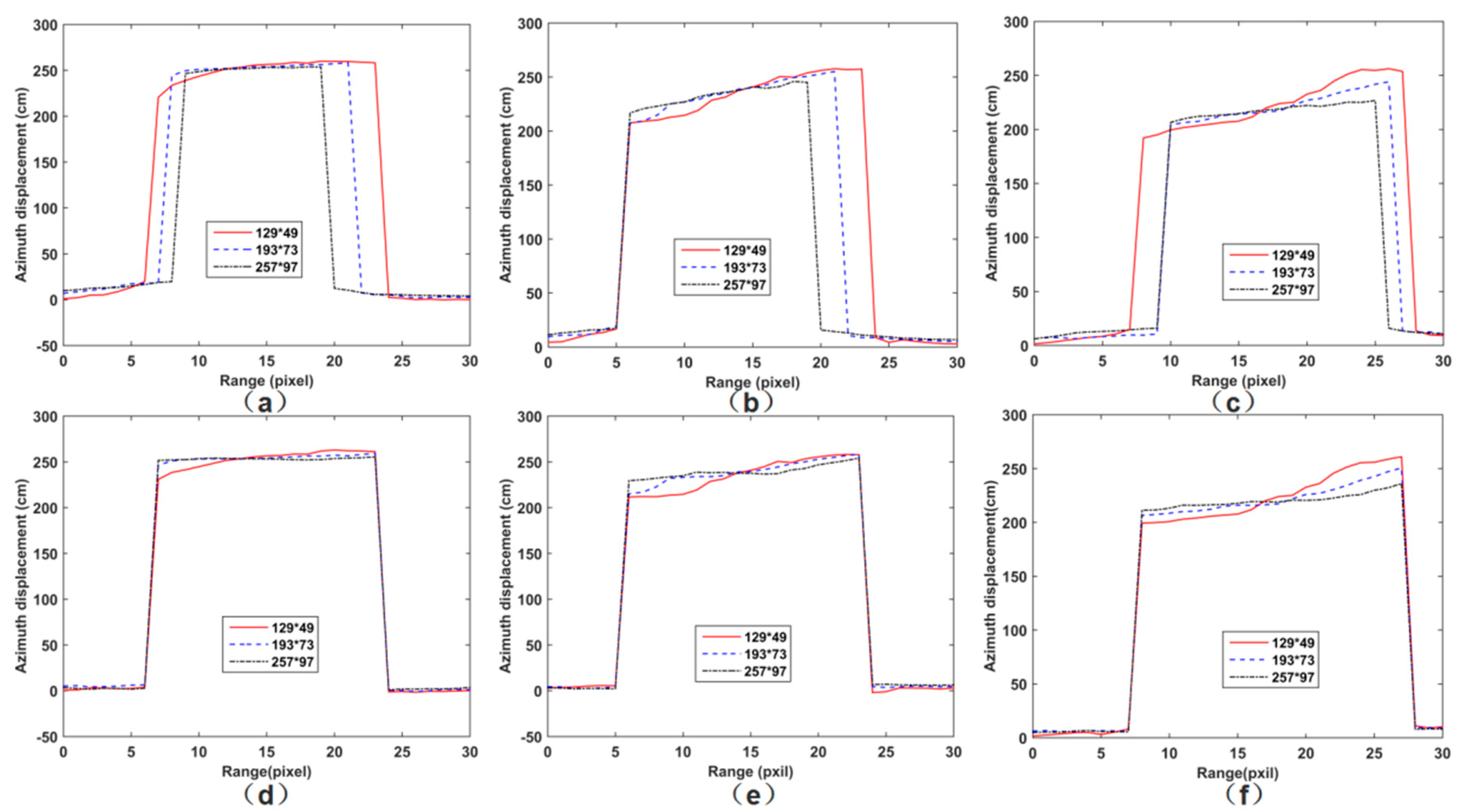
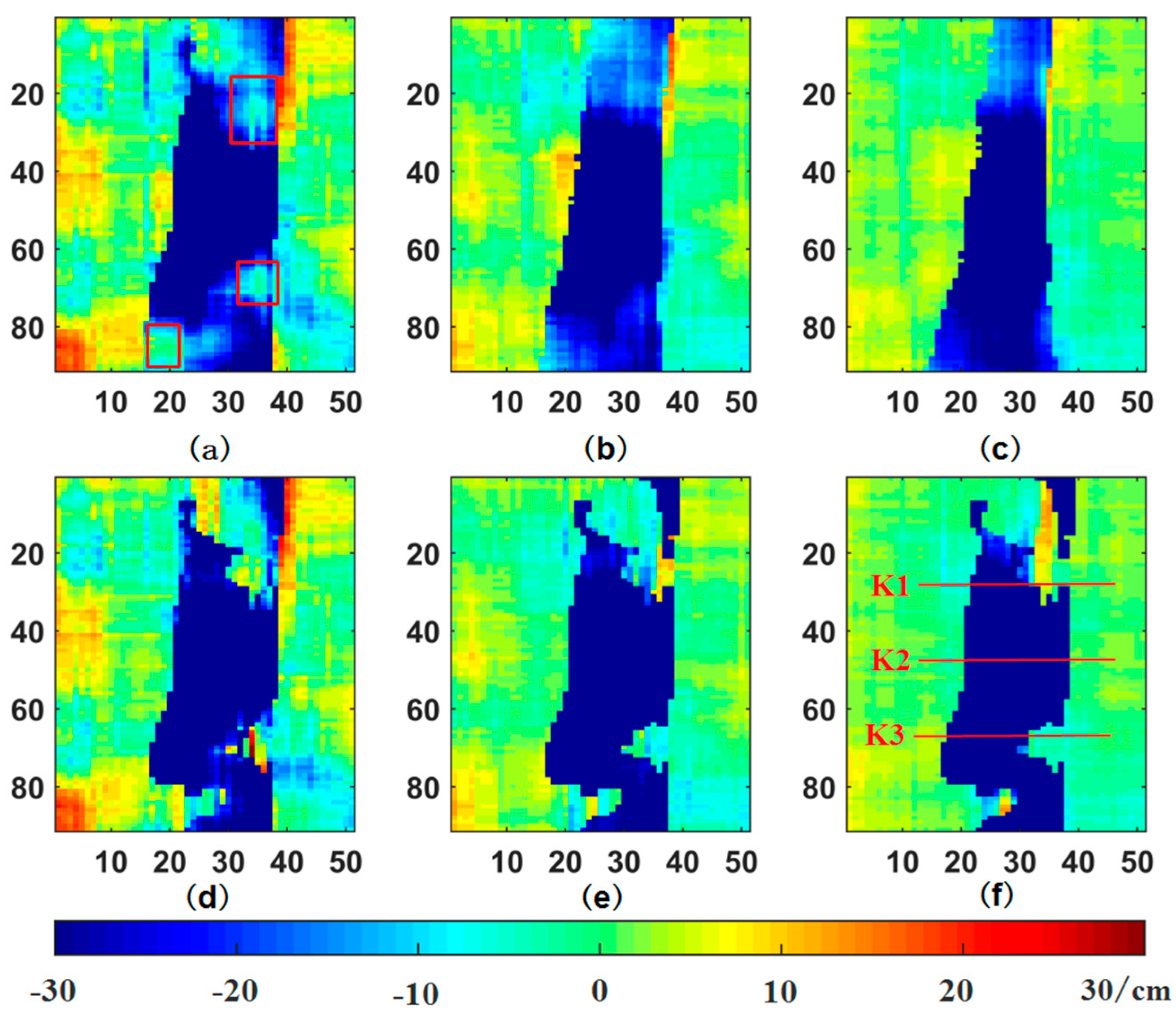
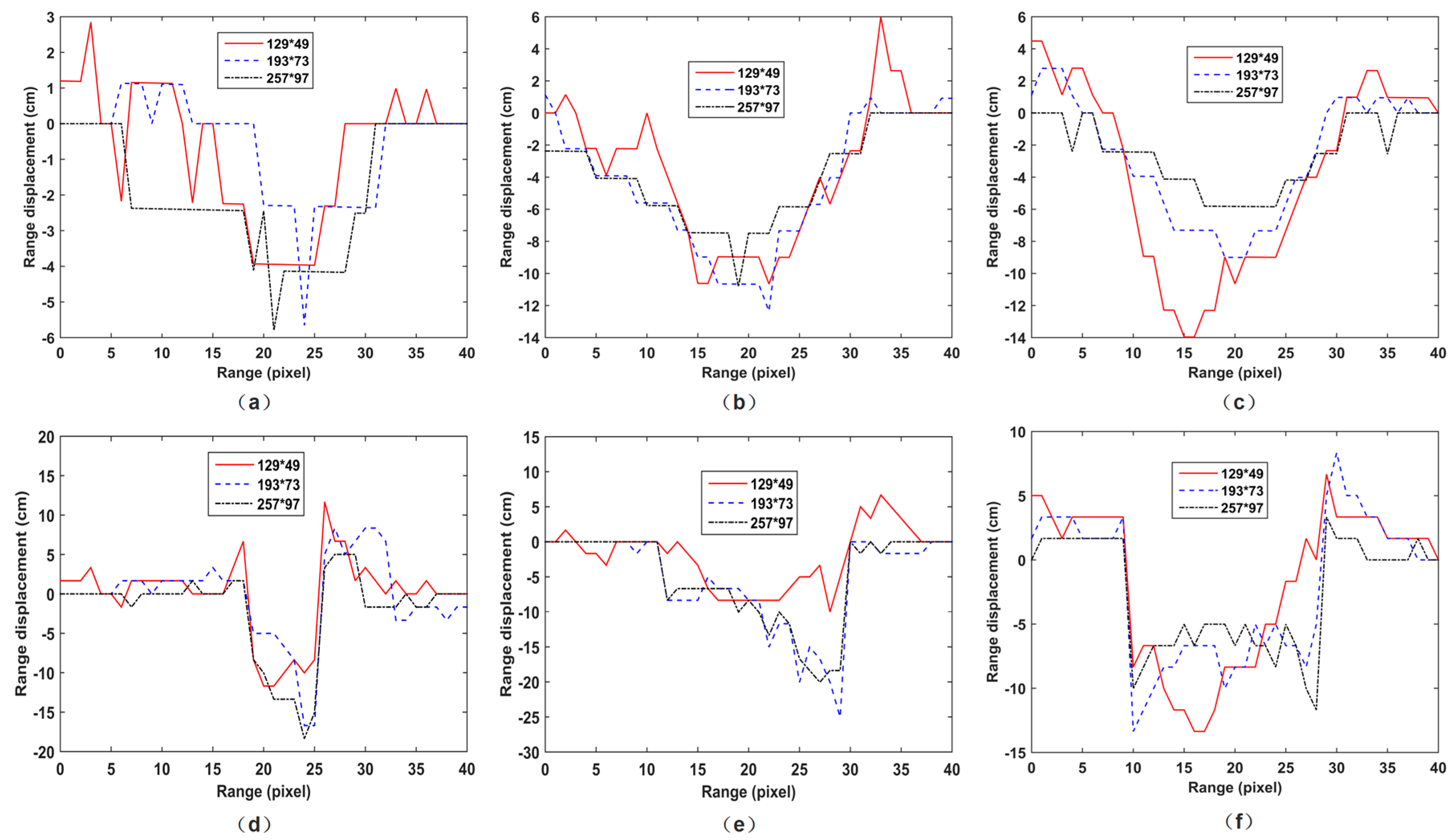
4.2. Stability Evaluation with Different Size of Matching Windows
5. Conclusions
- (1)
- First, we compare the cross-correlation coefficients of the best matched points for the NCC and the ANCC methods. The NCC has much lower correlation values on the landslide boundaries, as it uses regular matching windows, which contain different types of moving characteristics. In contrast, the ANCC method uses adaptive matching windows, including pixels with similar moving characteristics. Then, it can greatly improve the estimation accuracy of displacements for the landslide.
- (2)
- Finally, we evaluate the stability with different size-matching windows for both methods. On the landslide boundaries, the displacements estimated by the classical NCC method are changing severely and become ambiguous with the increasing matching window size. In contrast, the proposed ANCC method has great stability in boundary areas, no matter the size of the matching window.
Acknowledgments
Author Contributions
Conflicts of Interest
References
- Petley, D.N. Global patterns of loss of life from landslides. Geology 2012, 40, 927–930. [Google Scholar] [CrossRef]
- Greif, V.; Vlcko, J. Monitoring of post-failure landslide deformation by the PS-InSAR technique at Lubietova in Central Slovakia. Environ. Earth Sci. 2011, 66, 1585–1595. [Google Scholar] [CrossRef]
- Singleton, A.; Li, Z.; Hoey, T.B.; Muller, J.P. Evaluating sub-pixel offset techniques as an alternative to D-InSAR for monitoring episodic landslide movements in vegetated terrain. Remote Sens. Environ. 2014, 147, 133–144. [Google Scholar] [CrossRef]
- Rosen, P.A.; Hensley, S.; Joughin, I.; Li, F.; Madsen, S.N.; Rodriguez, E.; Goldstein, R.M. Synthetic aperture radar interferometry. Proc. IEEE 2000, 88, 333–382. [Google Scholar] [CrossRef]
- Ferretti, A.; Prati, C.; Rocca, F. Multibaseline InSAR DEM Reconstruction: The Wavelet Approach. IEEE Trans. Geosci. Remote Sens. 1999, 37, 705–715. [Google Scholar] [CrossRef]
- Rossi, C.; Gonzalez, F.R.; Fritz, T.; Yaguemartinez, N.; Eineder, M. TanDEM-X calibrated Raw DEM generation. ISPRS J. Photogramm. Remote Sens. 2012, 73, 12–20. [Google Scholar] [CrossRef]
- Khati, U.; Singh, G.; Ferro-Famil, L. Analysis of seasonal effects on forest parameter estimation of Indian deciduous forest using TerraSAR-X PolInSAR acquisitions. Remote Sens. Environ. 2017, 199, 265–276. [Google Scholar] [CrossRef]
- Wang, C.; Wang, L.; Fu, H.; Xie, Q.; Zhu, J. The Impact of Forest Density on Forest Height Inversion Modeling from Polarimetric InSAR Data. Remote Sens. 2016, 8, 291. [Google Scholar] [CrossRef]
- Marom, M.; Goldstein, R.M.; Thornton, E.B.; Shemer, L. Remote sensing of ocean wave spectra by interferometric synthetic aperture radar. Nature 1990, 345, 793–795. [Google Scholar] [CrossRef]
- Colesanti, C.; Wasowski, J. Investigating landslides with space-borne Synthetic Aperture Radar (SAR) interferometry. Eng. Geol. 2006, 88, 173–199. [Google Scholar] [CrossRef]
- Herrera, G.; Notti, D.; Garciadavalillo, J.C.; Mora, O.; Cooksley, G.; Sanchez, M.; Crosetto, M. Analysis with C- and X-band satellite SAR data of the Portalet landslide area. Landslides 2010, 8, 195–206. [Google Scholar] [CrossRef]
- Liu, P.; Li, Z.; Hoey, T.B.; Kincal, C.; Zhang, J.; Zeng, Q.; Muller, J. Using advanced InSAR time series techniques to monitor landslide movements in Badong of the Three Gorges region, China. Int. J. Appl. Earth Obs. Geoinf. 2013, 21, 253–264. [Google Scholar] [CrossRef]
- Herrera, G.; Fernandezmerodo, J.A.; Mulas, J.; Pastor, M.; Luzi, G.; Monserrat, O. A landslide forecasting model using ground based SAR data: The Portalet case study. Eng. Geol. 2009, 105, 220–230. [Google Scholar] [CrossRef]
- Sun, Q.; Hu, J.; Zhang, L.; Ding, X. Towards Slow-Moving Landslide Monitoring by Integrating Multi-Sensor InSAR Time Series Datasets: The Zhouqu Case Study, China. Remote Sens. 2016, 8, 908. [Google Scholar] [CrossRef]
- Gabriel, A.K.; Goldstein, R.M.; Zebker, H.A. Mapping small elevation changes over large areas: Differential radar interferometry. J. Geophys. Res. 1989, 94, 9183–9191. [Google Scholar] [CrossRef]
- Bamler, R.; Eineder, M. Accuracy of differential shift estimation by correlation and split-bandwidth interferometry for wideband and delta-k SAR systems. IEEE Geosci. Remote Sens. Lett. 2005, 2, 151–155. [Google Scholar] [CrossRef]
- Zhang, L.; Liao, M.; Balz, T.; Shi, X.; Jiang, Y. Monitoring Landslide Activities in the Three Gorges Area with Multi-frequency Satellite SAR Data Sets. In Modern Technologies for Landslide Monitoring and Prediction; Springer: Berlin/Heidelberg, Germany, 2015; pp. 181–208. [Google Scholar]
- Mittermayer, J.; Wollstadt, S.J.; Prats, P.; Koppe, W. Staring spotlight imaging with TerraSAR-X. In Proceedings of the International Geoscience and Remote Sensing Symposium, Munich, Germany, 22–27 July 2012. [Google Scholar]
- Milillo, P.; Riel, B.; Minchew, B.; Yun, S.; Simons, M.; Lundgren, P. On the Synergistic Use of SAR Constellations’ Data Exploitation for Earth Science and Natural Hazard Response. IEEE J. Sel. Top. Appl. Earth Obs. Remote Sens. 2016, 9, 1095–1100. [Google Scholar] [CrossRef]
- Ding, C.; Feng, G.; Li, Z.; Shan, X.; Du, Y.; Wang, H. Spatio-Temporal Error Sources Analysis and Accuracy Improvement in Landsat 8 Image Ground Displacement Measurements. Remote Sens. 2016, 8, 937. [Google Scholar] [CrossRef]
- Michel, R.; Avouac, J.; Taboury, J. Measuring near field coseismic displacements from SAR images: Application to the Landers Earthquake. Geophys. Res. Lett. 1999, 26, 3017–3020. [Google Scholar] [CrossRef]
- Fialko, Y.A.; Sandwell, D.T.; Simons, M.; Rosen, P.A. Three-dimensional deformation caused by the Bam, Iran, earthquake and the origin of shallow slip deficit. Nature 2005, 435, 295–299. [Google Scholar] [CrossRef] [PubMed]
- Fielding, E.J.; Lundgren, P.R.; Taymaz, T.; Yolsalcevikbilen, S.; Owen, S.E. Fault-Slip Source Models for the 2011 M 7.1 Van Earthquake in Turkey from SAR Interferometry, Pixel Offset Tracking, GPS, and Seismic Waveform Analysis. Seismol. Res. Lett. 2013, 84, 579–593. [Google Scholar] [CrossRef]
- Wang, T.; Wei, S.; Jónsson, S. Coseismic displacements from SAR image offsets between different satellite sensors: Application to the 2001 Bhuj (India) earthquake. Geophys. Res. Lett. 2015, 42, 7022–7030. [Google Scholar] [CrossRef]
- Wang, T.; Jónsson, S. Improved SAR amplitude image offset measurements for deriving three-dimensional coseismic displacements. IEEE J. Sel. Top. Appl. Earth Obs. Remote Sens. 2015, 8, 3271–3278. [Google Scholar] [CrossRef]
- Pritchard, H.D.; Murray, T.; Luckman, A.; Strozzi, T.; Barr, S. Glacier surge dynamics of Sortebræ, east Greenland, from synthetic aperture radar feature tracking. J. Geophys. Res. 2005, 110. [Google Scholar] [CrossRef]
- Schubert, A.; Faes, A.; Kaab, A.; Meier, E. Glacier surface velocity estimation using repeat TerraSAR-X images: Wavelet- vs. correlation-based image matching. ISPRS J. Photogramm. Remote Sens. 2013, 82, 49–62. [Google Scholar] [CrossRef]
- Neelmeijer, J.; Motagh, M.; Wetzel, H.-U. Estimating Spatial and Temporal Variability in Surface Kinematics of the Inylchek Glacier, Central Asia, using TerraSAR-X Data. Remote Sens. 2014, 6, 9239–9259. [Google Scholar] [CrossRef]
- Zhou, Y.; Li, Z.; Li, J. Slight glacier mass loss in the Karakoram region during the 1970s to 2000 revealed by KH-9 images and SRTM DEM. J. Glaciol. 2017, 63, 331–342. [Google Scholar] [CrossRef]
- Bhattacharya, A.; Mukherjee, K.; Kuri, M.; Voge, M.; Sharma, M.L.; Arora, M.K.; Bhasin, R.K. Potential of SAR intensity tracking technique to estimate displacement rate in a landslide-prone area in Haridwar region, India. Nat. Hazards 2015, 79, 2101–2121. [Google Scholar] [CrossRef]
- Giles, A.B.; Massom, R.A.; Warner, R.C. A method for sub-pixel scale feature-tracking using Radarsat images applied to the Mertz Glacier Tongue, East Antarctica. Remote Sens. Environ. 2009, 113, 1691–1699. [Google Scholar] [CrossRef]
- Shi, X.; Zhang, L.; Balz, T.; Liao, M. Landslide deformation monitoring using point-like target offset tracking with multi-mode high-resolution TerraSAR-X data. ISPRS J. Photogramm. Remote Sens. 2015, 105, 128–140. [Google Scholar] [CrossRef]
- Casu, F.; Manconi, A.; Pepe, A.; Lanari, R. Deformation Time-Series Generation in Areas Characterized by Large Displacement Dynamics: The SAR Amplitude Pixel-Offset SBAS Technique. IEEE Trans. Geosci. Remote Sens. 2011, 49, 2752–2763. [Google Scholar] [CrossRef]
- Strozzi, T.; Luckman, A.; Murray, T.; Wegmuller, U.; Werner, C. Glacier motion estimation using SAR offset-tracking procedures. IEEE Trans. Geosci. Remote Sens. 2002, 40, 2384–2391. [Google Scholar] [CrossRef]
- Derauw, D. DInSAR and Coherence Tracking Applied to Glaciology: The Example of Shirase Glacier. 1999. Available online: https://pdfs.semanticscholar.org/3012/0dabd7fbec77338db321b2de7cfe0b4604f6.pdf (accessed on 11 August 2017).
- Zitova, B.; Flusser, J. Image registration methods: A survey. Image Vis. Comput. 2003, 21, 977–1000. [Google Scholar] [CrossRef]
- Heid, T.; Kaab, A. Evaluation of existing image matching methods for deriving glacier surface displacements globally from optical satellite imagery. Remote Sens. Environ. 2012, 118, 339–355. [Google Scholar] [CrossRef]
- Erten, E.; Reigber, A.; Hellwich, O.; Prats, P. Glacier Velocity Monitoring by Maximum Likelihood Texture Tracking. IEEE Trans. Geosci. Remote Sens. 2009, 47, 394–405. [Google Scholar] [CrossRef] [Green Version]
- Erten, E.; Reigber, A.; Ferrofamil, L.; Hellwich, O. A New Coherent Similarity Measure for Temporal Multichannel Scene Characterization. IEEE Trans. Geosci. Remote Sens. 2012, 50, 2839–2851. [Google Scholar] [CrossRef]
- Hu, X.; Wang, T.; Liao, M. Measuring coseismic displacements with point-like targets offset tracking. IEEE Geosci. Remote Sens. Lett. 2013, 11, 283–287. [Google Scholar] [CrossRef]
- Wang, C.; Mao, X.; Wang, Q. Landslide Displacement Monitoring by a Fully Polarimetric SAR Offset Tracking Method. Remote Sens. 2016, 8, 624. [Google Scholar] [CrossRef]
- Liu, J.; Iskander, M. Adaptive cross correlation for imaging displacements in soils. J. Comput. Civ. Eng. 2004, 18, 46–57. [Google Scholar] [CrossRef]
- Rosen, P.A.; Hensley, S.; Wheeler, K.; Sadowy, G. UAVSAR: A new NASA airborne SAR system for science and technology research. In Proceedings of the IEEE Conference on Radar, Verona, NY, USA, 24–27 April 2006; p. 8. [Google Scholar]
- Debellagilo, M.; Kaab, A. Sub-pixel precision image matching for measuring surface displacements on mass movements using normalized cross-correlation. Remote Sens. Environ. 2011, 115, 130–142. [Google Scholar] [CrossRef] [Green Version]
- Schulz, W.H.; Mckenna, J.P.; Biavati, G.; Kibler, J.D. Characteristics of slumgullion landslide inferred from subsurface exploration, in-situ and laboratory testing, and monitoring. IEEE Trans. Geosci. Remote Sens. 2007, 44, 2861–2870. [Google Scholar]
- Fleming, R.W.; Baum, R.L.; Giardino, M. Map and Description of the Active Part of the Slumgullion Landslide, Hinsdale County, Colorado; Geologic Investigations Series Map I-2672; U.S. Geological Survey: Reston, WV, USA, 1999.
- Coe, J.A.; Ellis, W.L.; Godt, J.W.; Savage, W.Z.; Savage, J.E.; Michael, J.A.; Debray, S.K. Seasonal movement of the Slumgullion landslide determined from global positioning system surveys and field instrumentation. Eng. Geol. 2003, 68, 67–101. [Google Scholar] [CrossRef]
- Coe, J.A. Regional moisture balance control of landslide motion: Implications for landslide forecasting in a changing climate. Geology 2012, 40, 323–326. [Google Scholar] [CrossRef]
- Schulz, W.H.; Kean, J.W.; Wang, G. Landslide movement in southwest Colorado triggered by atmospheric tides. Nat. Geosci. 2009, 2, 863–866. [Google Scholar] [CrossRef]
- Delbridge, B.G.; Burgmann, R.; Fielding, E.J.; Hensley, S. Kinematics of the slumgullion landslide from UAVSAR derived interferograms. In Proceedings of the International Geoscience and Remote Sensing Symposium, Milan, Italy, 26–31 July 2015; pp. 3842–3845. [Google Scholar]
- Milillo, P.; Fielding, E.J.; Shulz, W.H.; Delbridge, B.G.; Burgmann, R. COSMO-SkyMed Spotlight Interferometry Over Rural Areas: The Slumgullion Landslide in Colorado, USA. IEEE J. Sel. Top. Appl. Earth Obs. Remote Sens. 2014, 7, 2919–2926. [Google Scholar] [CrossRef]
- Delbridge, B.G.; Burgmann, R.; Fielding, E.J.; Hensley, S.; Schulz, W.H. Three-dimensional surface deformation derived from airborne interferometric UAVSAR: Application to the Slumgullion Landslide. J. Geophys. Res. 2016, 121, 3951–3977. [Google Scholar] [CrossRef]


| Acquired Time | Polarization | Azimuth Pixel Spacing | Range Pixel Spacing | Wavelength |
|---|---|---|---|---|
| 19 August 2011 | HH | 0.60 m | 1.67 m | 23.84 cm |
| 9 May 2012 | HH | 0.60 m | 1.67 m | 23.84 cm |
| 1 August 2012 | HH | 0.60 m | 1.67 m | 23.84 cm |
© 2017 by the authors. Licensee MDPI, Basel, Switzerland. This article is an open access article distributed under the terms and conditions of the Creative Commons Attribution (CC BY) license (http://creativecommons.org/licenses/by/4.0/).
Share and Cite
Cai, J.; Wang, C.; Mao, X.; Wang, Q. An Adaptive Offset Tracking Method with SAR Images for Landslide Displacement Monitoring. Remote Sens. 2017, 9, 830. https://doi.org/10.3390/rs9080830
Cai J, Wang C, Mao X, Wang Q. An Adaptive Offset Tracking Method with SAR Images for Landslide Displacement Monitoring. Remote Sensing. 2017; 9(8):830. https://doi.org/10.3390/rs9080830
Chicago/Turabian StyleCai, Jiehua, Changcheng Wang, Xiaokang Mao, and Qijie Wang. 2017. "An Adaptive Offset Tracking Method with SAR Images for Landslide Displacement Monitoring" Remote Sensing 9, no. 8: 830. https://doi.org/10.3390/rs9080830