Landslide Susceptibility Mapping Using GIS-Based Data Mining Algorithms


Abstract
:1. Introduction
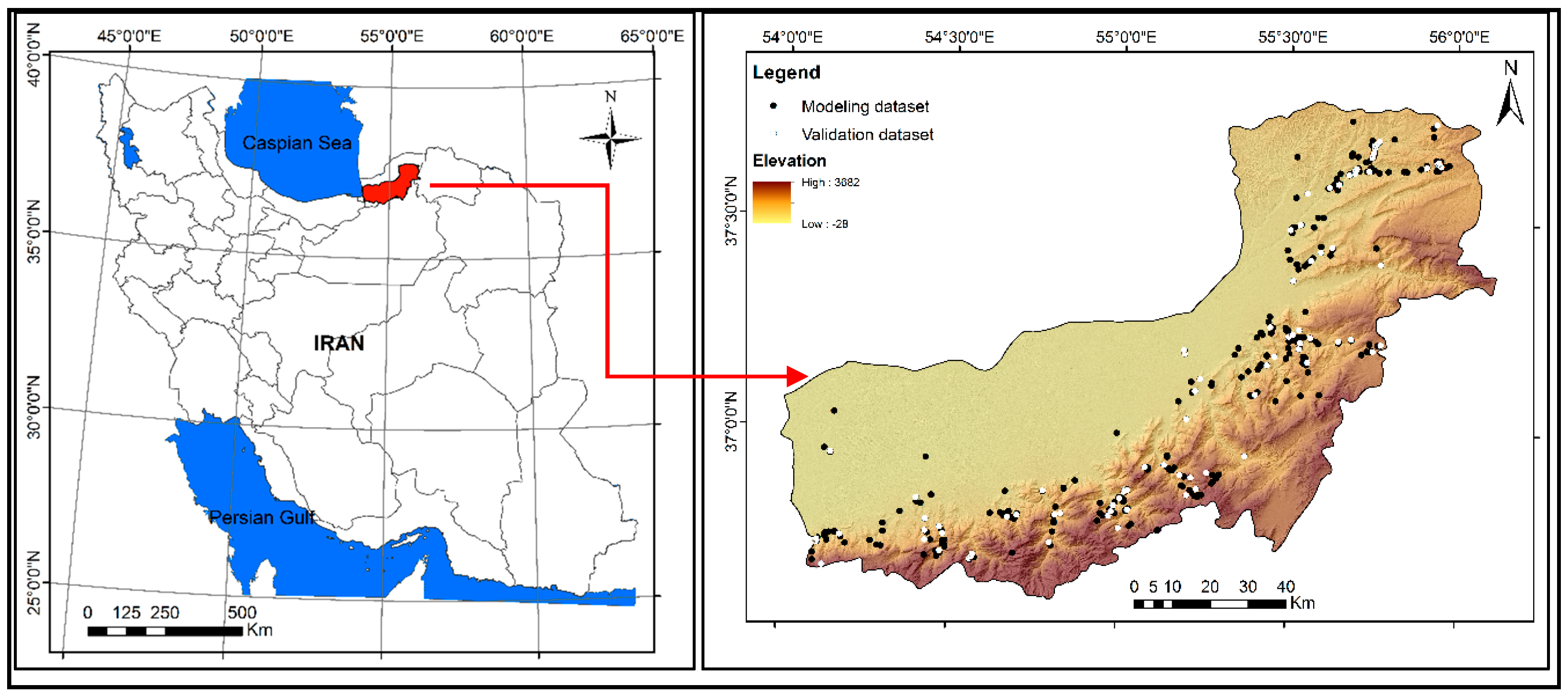
2. Study Area
3. Data and Information
4. Methods
- At the first stage, to find the correlation of the landslides with the causative factors and calculate the initial weights [9,100], the bivariate statistical method of FR is applied. In this method, the weight (Fri) of each class (i = 1, 2, 3, …, n) of a factor is equal to the percentage of its landslides divided by the percentage of its area as a ratio of the whole map;
- At the second stage, the Fris (the sixth column of Table 2) should be normalized in the standard interval of (0.1, 0.9) that results in the µi values (the last column of Table 2) as follows [101,102]:where, Frmin and Frmax are the minimum and maximum observed FR weights among the classes of a given factor. In this step, because the pixels with an equal µi in a factor layer are equally important in terms of affecting the occurrence of landslides, they can be merged together, which results in separate units. This act reduces the number of computations in the process of converting the data and employing the machine learning models. Additionally, the separate units with very close µi values (some units showed negligible differences in terms of the µi value) can also be integrated into single units. Apart from reducing the number of pixels, another advantage of the second stage is that the pixels’ values fall in a standard continuous range which means there is no unknown value in relation to the categorical factors and it helps to apply the machine learning models;
- At the third stage, the unique condition units of the study area are created by overlaying all the factors with the µi values in GIS software (e.g., using the Combine tool in ArcGIS® 10);
- The last stage involves creating a calibration dataset which is comprised of the µi values of both landslide and stable pixels extracted from the unique condition units. Both landslide and stable pixels are necessary for training some of the data mining models [57,81,93,103,104], such as BLR, BPANN, SVM, and C5DT (except for FG which was applied directly using the unique condition raster). The calibration dataset consisted of 80% landslide pixels (344 pixels in the modeling dataset) and 344 randomly selected stable pixels. A buffer distance of 100 m around the landslides was considered when randomly picking out the stable pixels to provide relative assurance of the insensitivity of these stable pixels, which in turn helped to increase the accuracy of the models. A low-volume text file (such as DBF, database file) of the calibration dataset was used in the training process of the machine learning models in statistical software (SPSS® Statistics 19 and SPSS® Modeler 18 in this study).
4.1. FG
4.2. BLR
4.3. BPANN
4.4. SVM
4.5. C5DT
4.6. Validation of the Built Models
5. Results and Discussion
5.1. The Relationship between the Landslides and Causative Factors
5.2. Application of the NFUC Method
5.3. Application of Different Data Mining Methods
5.4. Validation of the Data Mining Models
6. Conclusions
Author Contributions
Funding
Acknowledgments
Conflicts of Interest
References
- Sterlacchini, S.; Ballabio, C.; Blahut, J.; Masetti, M.; Sorichetta, A. Spatial agreement of predicted patterns in landslide susceptibility maps. Geomorphology 2011, 125, 51–61. [Google Scholar] [CrossRef]
- Froude, M.J.; Petley, D. Global fatal landslide occurrence from 2004 to 2016. Nat. Hazard Earth Sys. 2018, 18, 2161–2181. [Google Scholar] [CrossRef] [Green Version]
- Corominas, J.; van Westen, C.; Frattini, P.; Cascini, L.; Malet, J.-P.; Fotopoulou, S.; Catani, F.; Van Den Eeckhaut, M.; Mavrouli, O.; Agliardi, F. Recommendations for the quantitative analysis of landslide risk. Bull. Eng. Geol. Environ. 2014, 73, 209–263. [Google Scholar] [CrossRef]
- Fell, R.; Corominas, J.; Bonnard, C.; Cascini, L.; Leroi, E.; Savage, W.Z. Guidelines for landslide susceptibility, hazard and risk zoning for land use planning. Eng. Geol. 2008, 102, 85–98. [Google Scholar] [CrossRef] [Green Version]
- Dahal, R.K.; Hasegawa, S.; Bhandary, N.P.; Poudel, P.P.; Nonomura, A.; Yatabe, R. A replication of landslide hazard mapping at catchment scale. Geomatics, Nat. Hazards Risk 2012, 3, 161–192. [Google Scholar] [CrossRef]
- Glade, T.; Anderson, M.G.; Crozier, M.J. Landslide Hazard and Risk; John Wiley & Sons: Chichester, UK, 2005. [Google Scholar]
- Guzzetti, F.; Carrara, A.; Cardinali, M.; Reichenbach, P. Landslide hazard evaluation: A review of current techniques and their application in a multi-scale study, Central Italy. Geomorphology 1999, 31, 181–216. [Google Scholar] [CrossRef]
- Pradhan, A.; Kim, Y. Evaluation of a combined spatial multi-criteria evaluation model and deterministic model for landslide susceptibility mapping. Catena 2016, 140, 125–139. [Google Scholar] [CrossRef]
- Aleotti, P.; Chowdhury, R. Landslide hazard assessment: Summary review and new perspectives. Bull. Int. Assoc. Eng. Geol. 1999, 58, 21–44. [Google Scholar] [CrossRef]
- Althuwaynee, O.F.; Pradhan, B.; Lee, S. A novel integrated model for assessing landslide susceptibility mapping using CHAID and AHP pair-wise comparison. Int. J. Remote Sens. 2016, 37, 1190–1209. [Google Scholar] [CrossRef]
- Goetz, J.; Brenning, A.; Petschko, H.; Leopold, P. Evaluating machine learning and statistical prediction techniques for landslide susceptibility modeling. Comput. Geosci. 2015, 81, 1–11. [Google Scholar] [CrossRef]
- Guzzetti, F. Landslide Hazard and Risk Assessment. Ph.D. Thesis, Universitäts-und Landesbibliothek Bonn, Bonn, Germany, 2006. [Google Scholar]
- Reichenbach, P.; Rossi, M.; Malamud, B.D.; Mihir, M.; Guzzetti, F. A review of statistically-based landslide susceptibility models. Earth Sci. Rev. 2018, 180, 60–91. [Google Scholar] [CrossRef]
- Guzzetti, F.; Mondini, A.C.; Cardinali, M.; Fiorucci, F.; Santangelo, M.; Chang, K.-T. Landslide inventory maps: New tools for an old problem. Earth Sci. Rev. 2012, 112, 42–66. [Google Scholar] [CrossRef] [Green Version]
- Hansen, A. Landslide Hazard Analysis. In Slope Instability; Brunsden, D., Prior, D.B., Eds.; Wiley & Sons: New York, NY, USA, 1984; pp. 523–602. [Google Scholar]
- Mondini, A.; Guzzetti, F.; Reichenbach, P.; Rossi, M.; Cardinali, M.; Ardizzone, F. Semi-automatic recognition and mapping of rainfall induced shallow landslides using optical satellite images. Remote Sens. Environ. 2011, 115, 1743–1757. [Google Scholar] [CrossRef]
- Varnes, D.J. Slope movement types and processes. Spec. Rep. 1978, 176, 11–33. [Google Scholar]
- Crozier, M.J. Landslides: Causes, Consequences & Environment; Croom Helm Pub: London, UK, 1989. [Google Scholar]
- Dietrich, W.E.; Reiss, R.; Hsu, M.L.; Montgomery, D.R. A process-based model for colluvial soil depth and shallow landsliding using digital elevation data. Hydrol. Process. 1995, 9, 383–400. [Google Scholar] [CrossRef]
- Highland, L.; Bobrowsky, P.T. The Landslide Handbook: A Guide to Understanding Landslides; US Geological Survey: Reston, VA, USA, 2008.
- Carrara, A.; Cardinali, M.; Detti, R.; Guzzetti, F.; Pasqui, V.; Reichenbach, P. GIS techniques and statistical models in evaluating landslide hazard. Earth Surf. Process. Landf. 1991, 16, 427–445. [Google Scholar] [CrossRef]
- Harp, E.L.; Keefer, D.K.; Sato, H.P.; Yagi, H. Landslide inventories: The essential part of seismic landslide hazard analyses. Eng. Geol. 2011, 122, 9–21. [Google Scholar] [CrossRef]
- Van Westen, C.J.; Castellanos, E.; Kuriakose, S.L. Spatial data for landslide susceptibility, hazard, and vulnerability assessment: An overview. Eng. Geol. 2008, 102, 112–131. [Google Scholar] [CrossRef]
- Keefer, D.K.; Larsen, M.C. Assessing landslide hazards. Sci. 2007, 316, 1136–1138. [Google Scholar] [CrossRef]
- Cascini, L. Applicability of landslide susceptibility and hazard zoning at different scales. Eng. Geol. 2008, 102, 164–177. [Google Scholar] [CrossRef]
- Fan, W.; Wei, X.S.; Cao, Y.B.; Zheng, B. Landslide susceptibility assessment using the certainty factor and analytic hierarchy process. J. Mt. Sci. 2017, 14, 906–925. [Google Scholar] [CrossRef]
- Myronidis, D.; Papageorgiou, C.; Theophanous, S. Landslide susceptibility mapping based on landslide history and analytic hierarchy process (AHP). Nat. Hazards 2016, 81, 245–263. [Google Scholar] [CrossRef]
- Yalcin, A.; Yalçın, A. GIS-based landslide susceptibility mapping using analytical hierarchy process and bivariate statistics in Ardesen (Turkey): Comparisons of results and confirmations. Catena 2008, 72, 1–12. [Google Scholar] [CrossRef]
- Yoshimatsu, H.; Abe, S. A review of landslide hazards in Japan and assessment of their susceptibility using an analytical hierarchic process (AHP) method. Landslides 2006, 3, 149–158. [Google Scholar] [CrossRef]
- Cui, K.; Lu, D.; Li, W. Comparison of landslide susceptibility mapping based on statistical index, certainty factors, weights of evidence and evidential belief function models. Geocarto Int. 2017, 32, 935–955. [Google Scholar] [CrossRef]
- Dahal, R.K.; Hasegawa, S.; Nonomura, A.; Yamanaka, M.; Masuda, T.; Nishino, K. GIS-based weights-of-evidence modelling of rainfall-induced landslides in small catchments for landslide susceptibility mapping. Environ. Geol. 2008, 54, 311–324. [Google Scholar] [CrossRef]
- Ilia, I.; Tsangaratos, P. Applying weight of evidence method and sensitivity analysis to produce a landslide susceptibility map. Landslides 2016, 13, 379–397. [Google Scholar] [CrossRef]
- Pradhan, B.; Oh, H.J.; Buchroithner, M. Weights-of-evidence model applied to landslide susceptibility mapping in a tropical hilly area. Geomatics, Nat. Hazards Risk 2010, 1, 199–223. [Google Scholar] [CrossRef]
- Chen, W.; Chai, H.; Zhao, Z.; Wang, Q.; Hong, H. Landslide susceptibility mapping based on GIS and support vector machine models for the Qianyang County, China. Environ. Earth Sci. 2016, 75, 474. [Google Scholar] [CrossRef]
- Choi, J.; Oh, H.J.; Lee, H.J.; Lee, C.; Lee, S. Combining landslide susceptibility maps obtained from frequency ratio, logistic regression, and artificial neural network models using ASTER images and GIS. Eng. Geol. 2012, 124, 12–23. [Google Scholar] [CrossRef]
- Lee, S.; Talib, J.A. Probabilistic landslide susceptibility and factor effect analysis. Environ. Earth Sci. 2005, 47, 982–990. [Google Scholar] [CrossRef]
- Regmi, A.D.; Devkota, K.C.; Yoshida, K.; Pradhan, B.; Pourghasemi, H.R.; Kumamoto, T.; Akgun, A. Application of frequency ratio, statistical index, and weights-of-evidence models and their comparison in landslide susceptibility mapping in Central Nepal Himalaya. Arab. J. Geosci. 2014, 7, 725–742. [Google Scholar] [CrossRef]
- Regmi, A.D.; Yoshida, K.; Pourghasemi, H.R.; Dhital, M.R.; Pradhan, B. Landslide susceptibility mapping along Bhalubang—Shiwapur area of mid-Western Nepal using frequency ratio and conditional probability models. J. Mt. Sci. 2014, 11, 1266–1285. [Google Scholar] [CrossRef]
- Reis, S.; Yalcin, A.; Atasoy, M.; Nisanci, R.; Bayrak, T.; Erduran, M.; Sancar, C.; Ekercin, S. Remote sensing and GIS-based landslide susceptibility mapping using frequency ratio and analytical hierarchy methods in Rize province (NE Turkey). Environ. Earth Sci. 2012, 66, 2063–2073. [Google Scholar] [CrossRef]
- Ercanoglu, M.; Gokceoglu, C. Use of fuzzy relations to produce landslide susceptibility map of a landslide prone area (West Black Sea Region, Turkey). Eng. Geol. 2004, 75, 229–250. [Google Scholar] [CrossRef]
- Pourghasemi, H.R.; Pradhan, B.; Gokceoglu, C. Application of fuzzy logic and analytical hierarchy process (AHP) to landslide susceptibility mapping at Haraz watershed, Iran. Nat. Hazards 2012, 63, 965–996. [Google Scholar] [CrossRef]
- Vakhshoori, V.; Zare, M. Landslide susceptibility mapping by comparing weight of evidence, fuzzy logic, and frequency ratio methods. Geomat. Nat. Hazards Risk 2016, 7, 1731–1752. [Google Scholar] [CrossRef]
- Akgun, A. A comparison of landslide susceptibility maps produced by logistic regression, multi-criteria decision, and likelihood ratio methods: A case study at İzmir, Turkey. Landslides 2012, 9, 93–106. [Google Scholar] [CrossRef]
- Bai, S.B.; Lu, P.; Wang, J. Landslide susceptibility assessment of the Youfang catchment using logistic regression. J. Mt. Sci. 2015, 12, 816–827. [Google Scholar] [CrossRef]
- Colkesen, I.; Sahin, E.K.; Kavzoglu, T. Susceptibility mapping of shallow landslides using kernel-based Gaussian process, support vector machines and logistic regression. J. Afr. Earth Sci. 2016, 118, 53–64. [Google Scholar] [CrossRef]
- Du, G.-L.; Zhang, Y.-S.; Iqbal, J.; Yang, Z.-H.; Yao, X. Landslide susceptibility mapping using an integrated model of information value method and logistic regression in the Bailongjiang watershed, Gansu Province, China. J. Mt. Sci. 2017, 14, 249–268. [Google Scholar] [CrossRef]
- Gorsevski, P.V.; Gessler, P.E.; Foltz, R.B.; Elliot, W.J. Spatial Prediction of Landslide Hazard Using Logistic Regression and ROC Analysis. Trans. GIS 2006, 10, 395–415. [Google Scholar] [CrossRef]
- Mancini, F.; Ceppi, C.; Ritrovato, G. GIS and statistical analysis for landslide susceptibility mapping in the Daunia area, Italy. Nat. Hazards Earth Syst. Sci. 2010, 10, 1851–1864. [Google Scholar] [CrossRef] [Green Version]
- Raja, N.B.; Çiçek, I.; Türkoğlu, N.; Aydin, O.; Kawasaki, A.; Aydın, O. Correction to: Landslide susceptibility mapping of the Sera River Basin using logistic regression model. Nat. Hazards 2017, 91, 1423. [Google Scholar] [CrossRef]
- Chauhan, S.; Sharma, M.; Arora, M.; Gupta, N. Landslide Susceptibility Zonation through ratings derived from Artificial Neural Network. Int. J. Appl. Earth Obs. Geoinf. 2010, 12, 340–350. [Google Scholar] [CrossRef]
- Chen, W.; Pourghasemi, H.R.; Zhao, Z. A GIS-based comparative study of Dempster-Shafer, logistic regression and artificial neural network models for landslide susceptibility mapping. Geocarto Int. 2017, 32, 367–385. [Google Scholar] [CrossRef]
- Gorsevski, P.V.; Brown, M.K.; Panter, K.; Onasch, C.M.; Simic, A.; Snyder, J. Landslide detection and susceptibility mapping using LiDAR and an artificial neural network approach: A case study in the Cuyahoga Valley National Park, Ohio. Landslides 2016, 13, 467–484. [Google Scholar] [CrossRef]
- Pradhan, B.; Lee, S. Landslide susceptibility assessment and factor effect analysis: Backpropagation artificial neural networks and their comparison with frequency ratio and bivariate logistic regression modelling. Environ. Model. Softw. 2010, 25, 747–759. [Google Scholar] [CrossRef]
- Zare, M.; Pourghasemi, H.R.; Vafakhah, M.; Pradhan, B. Landslide susceptibility mapping at Vaz Watershed (Iran) using an artificial neural network model: A comparison between multilayer perceptron (MLP) and radial basic function (RBF) algorithms. Arab. J. Geosci. 2013, 6, 2873–2888. [Google Scholar] [CrossRef]
- Zeng-Wang, X. GIS and ANN model for landslide susceptibility mapping. J. Geogr. Sci. 2001, 11, 374–381. [Google Scholar] [CrossRef]
- Chen, W.; Pourghasemi, H.R.; Panahi, M.; Kornejady, A.; Wang, J.; Xie, X.; Cao, S. Spatial prediction of landslide susceptibility using an adaptive neuro-fuzzy inference system combined with frequency ratio, generalized additive model, and support vector machine techniques. Geomorphology 2017, 297, 69–85. [Google Scholar] [CrossRef]
- Hong, H.; Pradhan, B.; Bui, D.T.; Xu, C.; Youssef, A.M.; Chen, W. Comparison of four kernel functions used in support vector machines for landslide susceptibility mapping: A case study at Suichuan area (China). Geomat Nat. Hazards Risk 2017, 8, 544–569. [Google Scholar] [CrossRef]
- Pradhan, B. A comparative study on the predictive ability of the decision tree, support vector machine and neuro-fuzzy models in landslide susceptibility mapping using GIS. Comput. Geosci. 2013, 51, 350–365. [Google Scholar] [CrossRef]
- Wu, X.; Ren, F.; Niu, R. Landslide susceptibility assessment using object mapping units, decision tree, and support vector machine models in the Three Gorges of China. Environ. Earth Sci. 2014, 71, 4725–4738. [Google Scholar] [CrossRef]
- Günther, A.; Eeckhaut, M.V.D.; Malet, J.-P.; Reichenbach, P.; Hervás, J. Climate-physiographically differentiated Pan-European landslide susceptibility assessment using spatial multi-criteria evaluation and transnational landslide information. Geomorphology 2014, 224, 69–85. [Google Scholar] [CrossRef]
- Thiery, Y.; Malet, J.-P.; Sterlacchini, S.; Puissant, A.; Maquaire, O. Landslide susceptibility assessment by bivariate methods at large scales: Application to a complex mountainous environment. Geomorphology 2007, 92, 38–59. [Google Scholar] [CrossRef] [Green Version]
- Trigila, A.; Frattini, P.; Casagli, N.; Catani, F.; Crosta, G.; Esposito, C.; Iadanza, C.; Lagomarsino, D.; Mugnozza, G.S.; Segoni, S.; et al. Landslide Susceptibility Mapping at National Scale: The Italian Case Study. In Landslide Science and Practice; Springer: Berlin/Heidelberg, Germany, 2013; pp. 287–295. [Google Scholar] [Green Version]
- Van Westen, C.; Van Asch, T.W.; Soeters, R. Landslide hazard and risk zonation—Why is it still so difficult? Bull. Eng. Geol. Environ. 2006, 65, 167–184. [Google Scholar] [CrossRef]
- Gaprindashvili, G.; Van Westen, C.J. Generation of a national landslide hazard and risk map for the country of Georgia. Nat. Hazards 2016, 80, 69–101. [Google Scholar] [CrossRef]
- Günther, A.; Reichenbach, P.; Malet, J.-P.; Van Den Eeckhaut, M.; Hervás, J.; Dashwood, C.; Guzzetti, F. Tier-based approaches for landslide susceptibility assessment in Europe. Landslides 2013, 10, 529–546. [Google Scholar] [CrossRef]
- Liu, C.; Li, W.; Wu, H.; Lu, P.; Sang, K.; Sun, W.; Chen, W.; Hong, Y.; Li, R. Susceptibility evaluation and mapping of China’s landslides based on multi-source data. Nat. Hazards 2013, 69, 1477–1495. [Google Scholar] [CrossRef]
- Van Den Eeckhaut, M.; Hervás, J.; Jaedicke, C.; Malet, J.P.; Montanarella, L.; Nadim, F. Statistical modelling of Europe-wide landslide susceptibility using limited landslide inventory data. Landslides 2012, 9, 357–369. [Google Scholar] [CrossRef]
- Li, Y.; Zhang, Y.; Huang, X.; Yuille, A.L. Deep networks under scene-level supervision for multi-class geospatial object detection from remote sensing images. ISPRS J. Photogramm. Remote Sens. 2018, 146, 182–196. [Google Scholar] [CrossRef]
- Li, Y.; Zhang, Y.; Huang, X.; Zhu, H.; Ma, J. Large-Scale Remote Sensing Image Retrieval by Deep Hashing Neural Networks. IEEE Trans. Geosci. Remote Sens. 2017, 56, 950–965. [Google Scholar] [CrossRef]
- Ghorbanzadeh, O.; Blaschke, T.; Gholamnia, K.; Meena, S.R.; Tiede, D.; Aryal, J. Evaluation of Different Machine Learning Methods and Deep-Learning Convolutional Neural Networks for Landslide Detection. Remote Sens. 2019, 11, 196. [Google Scholar] [CrossRef]
- Lee, S.; Kim, Y.; Min, K. Development of spatial landslide information system and application of spatial landslide information. J. Gis Assoc. Korea 2000, 8, 141–153. [Google Scholar]
- Lee, S.; Ryu, J.-H.; Kim, I.-S. Landslide susceptibility analysis and its verification using likelihood ratio, logistic regression, and artificial neural network models: Case study of Youngin, Korea. Landslides 2007, 4, 327–338. [Google Scholar] [CrossRef]
- Yilmaz, I. Landslide susceptibility mapping using frequency ratio, logistic regression, artificial neural networks and their comparison: A case study from Kat landslides (Tokat—Turkey). Comput. Geosci. 2009, 35, 1125–1138. [Google Scholar] [CrossRef]
- Shahabi, H.; Hashim, M.; Bin Ahmad, B. Remote sensing and GIS-based landslide susceptibility mapping using frequency ratio, logistic regression, and fuzzy logic methods at the central Zab basin, Iran. Environ. Earth Sci. 2015, 73, 8647–8668. [Google Scholar] [CrossRef]
- Sahana, M.; Sajjad, H. Evaluating effectiveness of frequency ratio, fuzzy logic and logistic regression models in assessing landslide susceptibility: A case from Rudraprayag district, India. J. Mt. Sci. 2017, 14, 2150–2167. [Google Scholar] [CrossRef]
- Balteanu, D.; Chendeș, V.; Sima, M.; Enciu, P. A country-wide spatial assessment of landslide susceptibility in Romania. Geomorphology 2010, 124, 102–112. [Google Scholar] [CrossRef]
- Holec, J.; Bednárik, M.; Šabo, M.; Minár, J.; Yilmaz, I.; Marschalko, M.; Yilmaz, I. A small-scale landslide susceptibility assessment for the territory of Western Carpathians. Nat. Hazards 2013, 69, 1081–1107. [Google Scholar] [CrossRef]
- Komac, B.; Zorn, M. Statistical landslide susceptibility modeling on a national scale: The example of Slovenia. Rev. Roum. Géogr. 2009, 53, 179–195. [Google Scholar]
- Sabatakakis, N.; Koukis, G.; Vassiliades, E.; Lainas, S. Landslide susceptibility zonation in Greece. Nat. Hazards 2013, 65, 523–543. [Google Scholar] [CrossRef]
- Park, S.; Choi, C.; Kim, B.; Kim, J. Landslide susceptibility mapping using frequency ratio, analytic hierarchy process, logistic regression, and artificial neural network methods at the Inje area, Korea. Environ. Earth Sci. 2013, 68, 1443–1464. [Google Scholar] [CrossRef]
- Bui, D.T.; Pradhan, B.; Löfman, O.; Revhaug, I. Landslide Susceptibility Assessment in Vietnam Using Support Vector Machines, Decision Tree, and Naïve Bayes Models. Math. Probl. Eng. 2012, 2012, 1–26. [Google Scholar]
- Glade, T. Landslide Hazard Assessment and Historical Landslide Data—An Inseparable Couple? In The Use of Historical Data in Natural Hazard Assessments; Springer: Berlin/Heidelberg, Germany, 2001; pp. 153–168. [Google Scholar]
- Ibsen, M.-L.; Brunsden, D. The nature, use and problems of historical archives for the temporal occurrence of landslides, with specific reference to the south coast of Britain, Ventnor, Isle of Wight. Geomorphology 1996, 15, 241–258. [Google Scholar] [CrossRef]
- Lang, A.; Moya, J.; Corominas, J.; Schrott, L.; Dikau, R. Classic and new dating methods for assessing the temporal occurrence of mass movements. Geomorphology 1999, 30, 33–52. [Google Scholar] [CrossRef]
- Zêzere, J.; Pereira, S.; Melo, R.; Oliveira, S.; Garcia, R.A.C. Mapping landslide susceptibility using data-driven methods. Sci. Total Environ. 2017, 589, 250–267. [Google Scholar] [CrossRef]
- Wang, X.; Zhang, L.; Wang, S.; Lari, S. Regional landslide susceptibility zoning with considering the aggregation of landslide points and the weights of factors. Landslides 2014, 11, 399–409. [Google Scholar] [CrossRef]
- Ardizzone, F.; Cardinali, M.; Carrara, A.; Guzzetti, F.; Reichenbach, P. Impact of mapping errors on the reliability of landslide hazard maps. Nat. Hazard Earth Sys. 2002, 2, 3–14. [Google Scholar] [CrossRef] [Green Version]
- Pradhan, B.; Mansor, S.; Pirasteh, S.; Buchroithner, M.F. Landslide hazard and risk analyses at a landslide prone catchment area using statistical based geospatial model. Int. J. Remote Sens. 2011, 32, 4075–4087. [Google Scholar] [CrossRef]
- Pourghasemi, H.R.; Jirandeh, A.G.; Pradhan, B.; Xu, C.; Gokceoglu, C. Landslide susceptibility mapping using support vector machine and GIS at the Golestan Province, Iran. J. Earth Syst. Sci. 2013, 122, 349–369. [Google Scholar] [CrossRef] [Green Version]
- Chung, C.J.F.; Fabbri, A.G. Validation of Spatial Prediction Models for Landslide Hazard Mapping. Nat. Hazards 2003, 30, 451–472. [Google Scholar] [CrossRef]
- Gritzner, M.L.; Marcus, W.A.; Aspinall, R.; Custer, S.G. Assessing landslide potential using GIS, soil wetness modeling and topographic attributes, Payette River, Idaho. Geomorphology 2001, 37, 149–165. [Google Scholar] [CrossRef]
- Moore, I.D.; Wilson, J.P. Length-slope factors for the Revised Universal Soil Loss Equation: Simplified method of estimation. J. Soil Water Conserv. 1992, 47, 423–428. [Google Scholar]
- Nefeslioglu, H.; Gokceoglu, C.; Sonmez, H. An assessment on the use of logistic regression and artificial neural networks with different sampling strategies for the preparation of landslide susceptibility maps. Eng. Geol. 2008, 97, 171–191. [Google Scholar] [CrossRef]
- Krzeminska, D.M.; Steele-Dunne, S.C.; Bogaard, T.A.; Rutten, M.M.; Sailhac, P.; Geraud, Y. High-resolution temperature observations to monitor soil thermal properties as a proxy for soil moisture condition in clay-shale landslide. Hydrol. Process. 2012, 26, 2143–2156. [Google Scholar] [CrossRef]
- Rianna, G.; Comegna, L.; Mercogliano, P.; Picarelli, L. Potential effects of climate changes on soil–atmosphere interaction and landslide hazard. Nat. Hazards 2016, 84, 1487–1499. [Google Scholar] [CrossRef]
- Daneshvar, M.R.M. Landslide susceptibility zonation using analytical hierarchy process and GIS for the Bojnurd region, northeast of Iran. Landslides 2014, 11, 1079–1091. [Google Scholar] [CrossRef]
- Süzen, M.L.; Doyuran, V. Data driven bivariate landslide susceptibility assessment using geographical information systems: A method and application to Asarsuyu catchment, Turkey. Eng. Geol. 2004, 71, 303–321. [Google Scholar] [CrossRef]
- Ferentinou, M.; Chalkias, C. Mapping Mass Movement Susceptibility across Greece with GIS, ANN and Statistical Methods. In Landslide Science and Practice; Springer: Berlin, Germany, 2013; pp. 321–327. [Google Scholar]
- Lima, P.; Steger, S.; Glade, T.; Tilch, N.; Schwarz, L.; Kociu, A. Landslide Susceptibility Mapping at National Scale: A First Attempt for Austria. In Workshop on World Landslide Forum; Springer: Cham, Switzerland, 2017; pp. 943–951. [Google Scholar]
- Ayalew, L.; Yamagishi, H. The application of GIS-based logistic regression for landslide susceptibility mapping in the Kakuda-Yahiko Mountains, Central Japan. Geomorphology 2005, 65, 15–31. [Google Scholar] [CrossRef]
- Lee, S. Application and verification of fuzzy algebraic operators to landslide susceptibility mapping. Environ. Geol. 2007, 52, 615–623. [Google Scholar] [CrossRef]
- Pradhan, B.; Lee, S.; Buchroithner, M.F. Use of geospatial data and fuzzy algebraic operators to landslide-hazard mapping. Appl. Geomat. 2009, 1, 3–15. [Google Scholar] [CrossRef] [Green Version]
- Caniani, D.; Pascale, S.; Sdao, F.; Sole, A. Neural networks and landslide susceptibility: A case study of the urban area of Potenza. Nat. Hazards 2008, 45, 55–72. [Google Scholar] [CrossRef]
- Feizizadeh, B.; Roodposhti, M.S.; Blaschke, T.; Aryal, J. Comparing GIS-based support vector machine kernel functions for landslide susceptibility mapping. Arab. J. Geosci. 2017, 10, 122. [Google Scholar] [CrossRef]
- Zadeh, L.A. Fuzzy sets. Inf. Cont. 1965, 8, 338–353. [Google Scholar] [CrossRef] [Green Version]
- Ercanoglu, M.; Temiz, F.A. Application of logistic regression and fuzzy operators to landslide susceptibility assessment in Azdavay (Kastamonu, Turkey). Environ. Earth Sci. 2011, 64, 949–964. [Google Scholar] [CrossRef]
- Sema, H.V.; Guru, B.; Veerappan, R. Fuzzy gamma operator model for preparing landslide susceptibility zonation mapping in parts of Kohima Town, Nagaland, India. Model. Earth Sys. Environ. 2017, 3, 499–514. [Google Scholar] [CrossRef]
- Tangestani, M.H. A comparative study of Dempster–Shafer and fuzzy models for landslide susceptibility mapping using a GIS: An experience from Zagros Mountains, SW Iran. J. Asian Earth Sci. 2009, 35, 66–73. [Google Scholar] [CrossRef]
- Pradhan, B. Landslide susceptibility mapping of a catchment area using frequency ratio, fuzzy logic and multivariate logistic regression approaches. J. Indian Soc. Remote Sens. 2010, 38, 301–320. [Google Scholar] [CrossRef]
- Chau, K.T.; Chan, J.E. Regional bias of landslide data in generating susceptibility maps using logistic regression: Case of Hong Kong Island. Landslides 2005, 2, 280–290. [Google Scholar] [CrossRef]
- Yang, I.T.; Chun, K.S.; Park, J.H. The effect of landslide factor and determination of landslide vulnerable area using GIS and AHP. J. Korean Soc. Geos. Inf. Sys. 2006, 14, 3–12. [Google Scholar]
- Lee, S. Application of logistic regression model and its validation for landslide susceptibility mapping using GIS and remote sensing data. Int. J. Remote Sens. 2005, 26, 1477–1491. [Google Scholar] [CrossRef]
- Zhu, L.; Huang, J.F. GIS-based logistic regression method for landslide susceptibility mapping in regional scale. J. Zhejiang Univ. A 2006, 7, 2007–2017. [Google Scholar] [CrossRef]
- Lee, S.; Sambath, T. Landslide susceptibility mapping in the Damrei Romel area, Cambodia using frequency ratio and logistic regression models. Environ. Earth Sci. 2006, 50, 847–855. [Google Scholar] [CrossRef]
- Cox, D.R.; Snell, E.J. Analysis of Binary Data, 2nd ed.; Chapman and Hall: London, UK, 1989. [Google Scholar]
- Nagelkerke, N.J.D. A note on a general definition of the coefficient of determination. Biometrika 1991, 78, 691–692. [Google Scholar] [CrossRef]
- Fuchu, D.; Lee, C.; Sijing, W. Analysis of rainstorm-induced slide-debris flows on natural terrain of Lantau Island, Hong Kong. Eng. Geol. 1999, 51, 279–290. [Google Scholar] [CrossRef]
- Kawabata, D.; Bandibas, J. Landslide susceptibility mapping using geological data, a DEM from ASTER images and an Artificial Neural Network (ANN). Geomorphology 2009, 113, 97–109. [Google Scholar] [CrossRef]
- Palani, S.; Liong, S.Y.; Tkalich, P. An ANN application for water quality forecasting. Mar. Pollut. Bull. 2008, 56, 1586–1597. [Google Scholar] [CrossRef]
- Lee, S.; Ryu, J.H.; Won, J.S.; Park, H.J. Determination and application of the weights for landslide susceptibility mapping using an artificial neural network. Eng. Geol. 2004, 71, 289–302. [Google Scholar] [CrossRef]
- Ermini, L.; Catani, F.; Casagli, N. Artificial Neural Networks applied to landslide susceptibility assessment. Geomorphology 2005, 66, 327–343. [Google Scholar] [CrossRef]
- Paola, J.D.; Schowengerdt, R.A. A review and analysis of backpropagation neural networks for classification of remotely-sensed multi-spectral imagery. Int. J. Remote Sens. 1995, 16, 3033–3058. [Google Scholar] [CrossRef]
- Negnevitsky, M. Artificial Intelligence: A Guide to Intelligent Systems; Pearson education: London, UK, 2005. [Google Scholar]
- Kanungo, D.P.; Arora, M.; Sarkar, S.; Gupta, R. A comparative study of conventional, ANN black box, fuzzy and combined neural and fuzzy weighting procedures for landslide susceptibility zonation in Darjeeling Himalayas. Eng. Geol. 2006, 85, 347–366. [Google Scholar] [CrossRef]
- Garrett, J. Where and why artificial neural networks are applicable in civil engineering. J. Comput. Civil Eng. 1994, 8, 129–130. [Google Scholar] [CrossRef]
- Congalton, R.G. Remote Sensing and Geographic Information System Data Integration: Error Sources and Research Issues. Photogramm. Eng. Rem. Sens. 1991, 57, 677–687. [Google Scholar]
- Swingler, K. Applying Neural Networks: A Practical Guide; Academic Press: New York, NY, USA, 1996. [Google Scholar]
- Gong, P. Integrated Analysis of Spatial Data from Multiple Sources: An Overview. Can. J. Remote Sens. 1994, 20, 349–359. [Google Scholar] [CrossRef]
- Chen, W.; Xie, X.; Wang, J.; Pradhan, B.; Hong, H.; Bui, D.T.; Duan, Z.; Ma, J. A comparative study of logistic model tree, random forest, and classification and regression tree models for spatial prediction of landslide susceptibility. Catena 2017, 151, 147–160. [Google Scholar] [CrossRef] [Green Version]
- IBM. Knowledge Center. Available online: https://www.ibm.com/support/knowledgecenter/en/SS3RA7_17.1.0/modeler_mainhelp_client_ddita/clementine/svm_node_experttab.html (accessed on 23 August 2019).
- Schlögel, R.; Braun, A.; Torgoev, A.; Fernández-Steeger, T.M.; Havenith, H.-B. Assessment of Landslides Activity in Maily-Say Valley, Kyrgyz Tien Shan. In Landslide Science and Practice; Springer: Berlin/Heidelberg, Germany, 2013; pp. 111–117. [Google Scholar]
- Lim, T.S.; Loh, W.Y.; Shih, Y.S. A Comparison of Prediction Accuracy, Complexity, and Training Time of Thirty-Three Old and New Classification Algorithms. Mach. Learn. 2000, 40, 203–228. [Google Scholar] [CrossRef]
- Cho, J.H.; Kurup, P.U. Decision tree approach for classification and dimensionality reduction of electronic nose data. Sensors Actuators B Chem. 2011, 160, 542–548. [Google Scholar] [CrossRef]
- Kuhn, M.; Johnson, K. Applied Predictive Modeling; Springer: New York, NY, USA, 2013; Volume 26. [Google Scholar]
- Aquino, L.D.; Tullis, J.A.; Stephen, F.M. Modeling red oak borer, Enaphalodes rufulus (Haldeman), damage using in situ and ancillary landscape data. For. Ecol. Manag. 2008, 255, 931–939. [Google Scholar] [CrossRef]
- Fakhr, M.; Elsayad, A.M. Steel Plates Faults Diagnosis with Data Mining Models. J. Comput. Sci. 2012, 8, 506–514. [Google Scholar] [Green Version]
- Nisbet, R.; Elder, J.; Miner, G. Handbook of Statistical Analysis and Data Mining Applications; Academic Press: London, UK, 2009. [Google Scholar]
- Wang, X.; Niu, R. Landslide intelligent prediction using object-oriented method. Soil Dyn. Earthq. Eng. 2010, 30, 1478–1486. [Google Scholar] [CrossRef]
- Begueria, S. Validation and Evaluation of Predictive Models in Hazard Assessment and Risk Management. Nat. Hazards 2006, 37, 315–329. [Google Scholar] [CrossRef] [Green Version]
- Fielding, A.H.; Bell, J.F. A review of methods for the assessment of prediction errors in conservation presence/absence models. Environ. Conserv. 1997, 24, 38–49. [Google Scholar] [CrossRef]
- Fawcett, T. An introduction to ROC analysis. Pattern Recogn. Lett. 2006, 27, 861–874. [Google Scholar] [CrossRef]
- Hanley, J.A.; McNeil, B.J. The meaning and use of the area under a receiver operating characteristic (ROC) curve. Radiology 1982, 143, 29–36. [Google Scholar] [CrossRef]
- Neuhäuser, B.; Damm, B.; Terhorst, B. GIS-based assessment of landslide susceptibility on the base of the weights-of-evidence model. Landslides 2012, 9, 511–528. [Google Scholar] [CrossRef]
- Pourghasemi, H.R.; Rahmati, O. Prediction of the landslide susceptibility: Which algorithm, which precision? Catena 2018, 162, 177–192. [Google Scholar] [CrossRef]
- Chung, C.-J.F.; Fabbri, A.G. Probabilistic prediction models for landslide hazard mapping. Photogramm. Eng. Rem. 1999, 65, 1389–1399. [Google Scholar]
- Fabbri, A.G.; Chung, C.J. On Blind Tests and Spatial Prediction Models. Nat. Resour. Res. 2008, 17, 107–118. [Google Scholar] [CrossRef] [Green Version]
- Dai, F.; Lee, C.; Ngai, Y. Landslide risk assessment and management: An overview. Eng. Geol. 2002, 64, 65–87. [Google Scholar] [CrossRef]
- Akgun, A.; Dag, S.; Bulut, F. Landslide susceptibility mapping for a landslide-prone area (Findikli, NE of Turkey) by likelihood-frequency ratio and weighted linear combination models. Environ. Geol. 2008, 54, 1127–1143. [Google Scholar] [CrossRef]
- Cannon, S. Debris-Flow Response of Southern California Watersheds Burned by Wildfire. In Proceedings of the Second International Conference on Debris-Flow Hazards Mitigation, Taipei, Taiwan, 16 August 2000; A.A. Balkema: Brookfield, WI, USA, 2000. [Google Scholar]
- Glade, T. Landslide occurrence as a response to land use change: A review of evidence from New Zealand. Catena 2003, 51, 297–314. [Google Scholar] [CrossRef]
- Varnes, D.J. Landslide Hazard Zonation: A Review of Principles and Practice; Unesco: Paris, France, 1984. [Google Scholar]
- Hasanat, M.H.A.; Ramachandram, D.; Mandava, R. Bayesian belief network learning algorithms for modeling contextual relationships in natural imagery: A comparative study. Artif. Intell. Rev. 2010, 34, 291–308. [Google Scholar] [CrossRef]


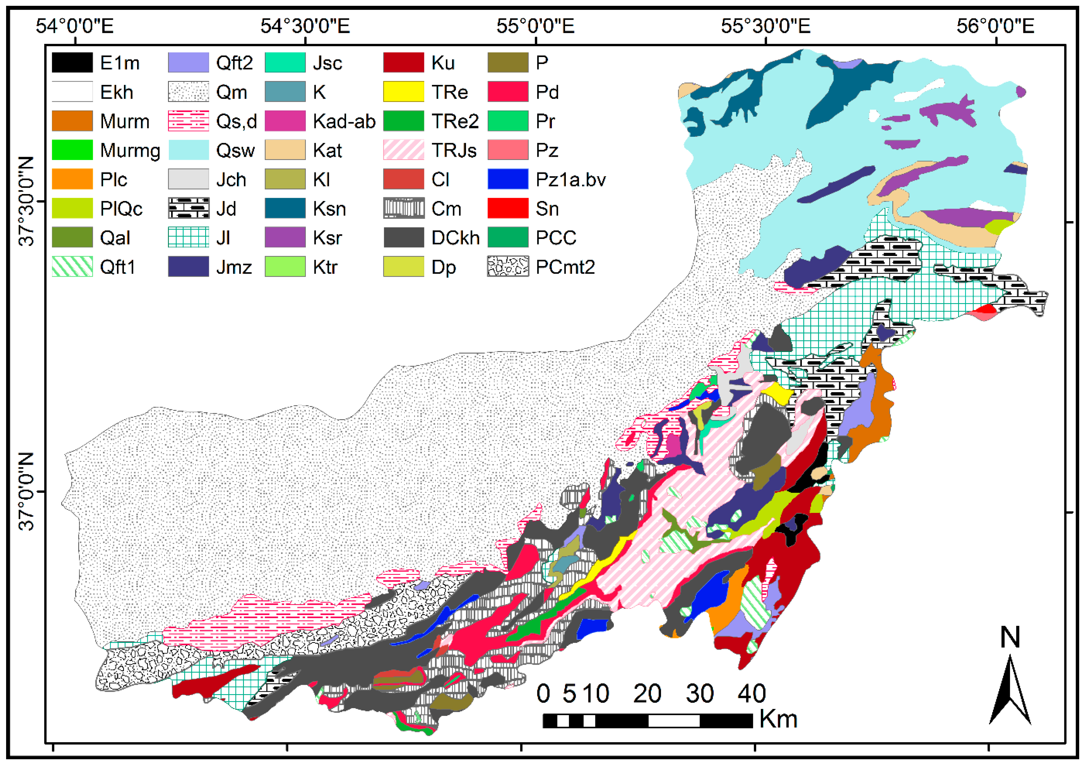
| Age | Code | Formation Name | Lithology |
|---|---|---|---|
| Cenozoic | E1m | _ | Marl, gypsiferous marl, and limestone |
| Ekh | Khangiran | Olive-green shale and sandstone | |
| Murm | _ | Light red to brown marl and gypsiferous marl with sandstone intercalations | |
| Murmg | _ | Gypsiferous marl | |
| Plc | _ | Polymictic conglomerate and sandstone | |
| PlQc | _ | Fluvial conglomerate, piedmont conglomerate, and sandstone | |
| Qal | _ | Stream channel, braided channel, and floodplain deposits | |
| Qft1 | _ | High-level piedmont fan and valley terrace deposits | |
| Qft2 | _ | Low-level pediment fan and valley terrace deposits | |
| Qm | _ | Swamp and marsh | |
| Qsd | _ | Unconsolidated wind-blown sand deposit including sand dunes | |
| Qsw | _ | Swamp | |
| Mesozoic | Jch | Chaman bid | Dark gray argillaceous limestone and marl |
| Jd | Dalichai | Well-bedded to thin-bedded, greenish-gray argillaceous limestone with intercalations of calcareous shale | |
| Jl | Lar | Light gray, thin bedded to massive limestone | |
| Jmz | Mozduran | Grey thick-bedded limestone and dolomite | |
| Jsc | _ | Conglomerate | |
| K | _ | Cretaceous rocks in general, include limestone, marly limestone, Inoceramus bearing | |
| Kad-ab | _ | Undifferentiated unit including argillaceous limestone, marl, and shale | |
| Kat | Aitamir | Olive green glauconitic sandstone and shale | |
| Kl | _ | Lower cretaceous undifferentiated rocks (Argillite, limestone, massive dolomite, sandstone) | |
| Ksn | Sanganeh | Grey to black shale and thin layers of siltstone and sandstone | |
| Ksr | Sarcheshmeh | Ammonite bearing shale with interaction of orbitolina limestone | |
| Ktr | Tirgan | Grey oolitic and bioclastic orbitolina limestone | |
| Ku | _ | Upper cretaceous, undifferentiated rocks | |
| TRe | Elikah | Thick bedded gray oolitic limestone; thin-platy, yellow to pinkish shale-limestone with worm tracks and well to thick-bedded dolomite and dolomitic limestone | |
| TRe2 | _ | Thick bedded dolomite | |
| TRJs | Shemshak | Dark-gray shale and sandstone | |
| Paleozoic | Cl | Lalun | Dark red medium-grained arkosic to sub arkosic sandstone and micaceous siltstone |
| Cm | Mobarak | Dark gray to black fossiliferous limestone with subordinate black shale | |
| DCkh | _ | Yellowish, thin to thick-bedded, fossiliferous argillaceous limestone, dark gray limestone, greenish marl, and shale, locally including gypsum | |
| Dp | Pabdeh | Light red to white, thick bedded quartzarenite with dolomite intercalations and gypsum | |
| P | _ | Undifferentiated Permian rocks | |
| Pd | Dorud | Red sandstone and shale with subordinate sandy limestone | |
| Pr | Ruteh | Dark-gray medium-bedded to massive limestone | |
| Pz | _ | Undifferentiated lower Paleozoic rocks | |
| Pz1a.bv | _ | Andesitic basaltic volcanic | |
| Sn | Niur | Greenish gray, shale, sandstone, sandy lime, coral limestone, and dolomite | |
| Proterozoic | PCC | _ | Late Proterozoic to early Cambrian undifferentiated rocks |
| PCmt2 | Greenschist facies | Low-grade, regional metamorphic rocks |
| Factor | Class | Class Area % | No. of Landslide | Landslide % | Fri | µi |
|---|---|---|---|---|---|---|
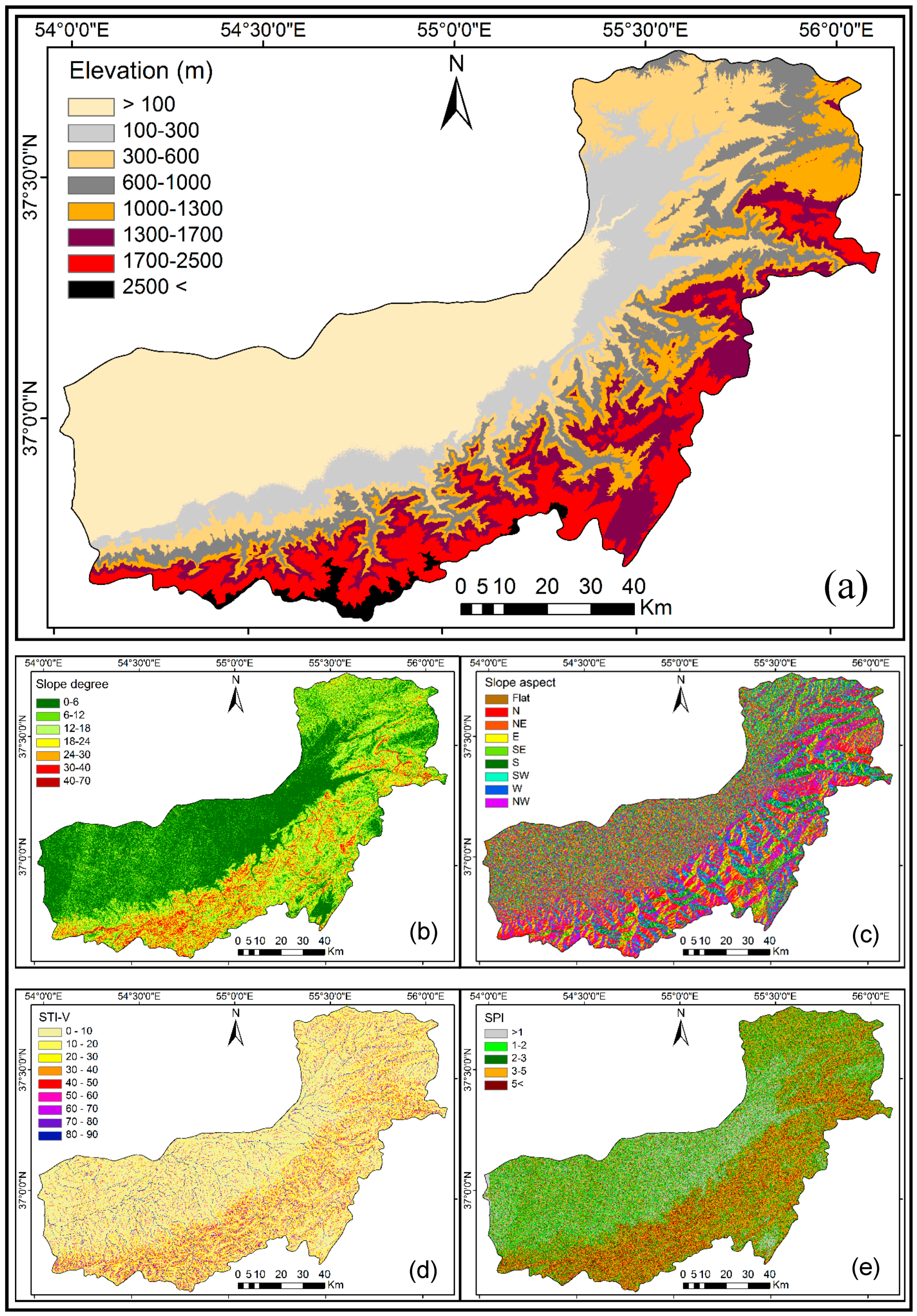
| Elevation (m above m.s.l.) | <100 | 32.29 | 6 | 1.74 | 0.050 | 0.118 |
| 100–300 | 12.16 | 63 | 18.31 | 1.500 | 0.648 | |
| 300–600 | 13.01 | 98 | 28.49 | 2.190 | 0.900 | |
| 600–1000 | 11.82 | 89 | 25.87 | 2.190 | 0.900 | |
| 1000–1300 | 9.33 | 49 | 14.24 | 1.520 | 0.655 | |
| 1300–1700 | 10.34 | 32 | 9.30 | 0.900 | 0.429 | |
| 1700–2500 | 9.68 | 7 | 2.03 | 0.210 | 0.177 | |
| 2500< | 1.33 | 0 | 0.00 | 0.000 | 0.100 | |
| Slope degree | 0–6 | 40.83 | 89 | 25.87 | 0.630 | 0.226 |
| 6-12 | 22.55 | 76 | 22.09 | 0.980 | 0.457 | |
| 12–18 | 15.40 | 76 | 22.09 | 1.430 | 0.755 | |
| 18–24 | 10.35 | 59 | 17.15 | 1.650 | 0.900 | |
| 24–30 | 6.17 | 27 | 7.85 | 1.270 | 0.649 | |
| 30–40 | 4.03 | 16 | 4.65 | 1.150 | 0.569 | |
| 40< | 0.65 | 1 | 0.29 | 0.440 | 0.100 | |
| Slope aspect | Flat | 0.23 | 0 | 0.00 | 0.000 | 0.100 |
| North | 17.42 | 60 | 17.44 | 1.000 | 0.740 | |
| Northeast | 12.00 | 32 | 9.30 | 0.770 | 0.593 | |
| East | 8.61 | 33 | 9.59 | 1.110 | 0.810 | |
| Southeast | 10.51 | 29 | 8.43 | 0.800 | 0.612 | |
| South | 13.32 | 52 | 15.11 | 1.130 | 0.823 | |
| Southwest | 11.18 | 48 | 13.95 | 1.250 | 0.900 | |
| West | 10.59 | 38 | 11.04 | 1.040 | 0.766 | |
| Northwest | 16.13 | 52 | 15.11 | 0.930 | 0.695 | |
| STI-V | 0–10 | 59.43 | 160 | 46.51 | 0.780 | 0.108 |
| 10–20 | 17.07 | 68 | 19.76 | 1.150 | 0.185 | |
| 20–30 | 7.41 | 19 | 5.52 | 0.740 | 0.100 | |
| 30–40 | 4.35 | 21 | 6.10 | 1.400 | 0.236 | |
| 40–50 | 3.06 | 10 | 2.90 | 0.950 | 0.143 | |
| 50–60 | 2.41 | 10 | 2.90 | 1.200 | 0.195 | |
| 60–70 | 2.10 | 8 | 2.32 | 1.100 | 0.174 | |
| 70–80 | 2.01 | 14 | 4.06 | 2.020 | 0.365 | |
| 80–90 | 2.14 | 34 | 9.88 | 4.610 | 0.900 | |
| SPI | <1 | 15.24 | 22 | 6.39 | 0.420 | 0.100 |
| 1–2 | 19.29 | 49 | 14.24 | 0.740 | 0.388 | |
| 2–3 | 21.29 | 90 | 26.16 | 1.230 | 0.828 | |
| 3–5 | 30.43 | 121 | 35.17 | 1.150 | 0.756 | |
| 5< | 13.73 | 62 | 18.02 | 1.310 | 0.900 | |
| Lithology (Code) | E1m | 0.35 | 0 | 0.00 | 0.000 | 0.100 |
| Ekh | 0.22 | 0 | 0.00 | 0.000 | 0.100 | |
| Murm | 0.70 | 3 | 0.87 | 1.250 | 0.239 | |
| Murmg | 0.00 | 0 | 0.00 | 0.000 | 0.100 | |
| Plc | 0.37 | 0 | 0.00 | 0.000 | 0.100 | |
| PlQc | 0.50 | 0 | 0.00 | 0.000 | 0.100 | |
| Qal | 0.21 | 0 | 0.00 | 0.000 | 0.100 | |
| Qft1 | 0.89 | 0 | 0.00 | 0.000 | 0.100 | |
| Qft2 | 0.87 | 6 | 1.74 | 1.990 | 0.321 | |
| Qm | 40.80 | 14 | 4.07 | 0.100 | 0.111 | |
| Qsd | 3.44 | 31 | 9.01 | 2.620 | 0.391 | |
| Qsw | 12.35 | 100 | 29.06 | 2.350 | 0.361 | |
| Jch | 0.51 | 6 | 1.74 | 3.400 | 0.477 | |
| Jd | 3.52 | 10 | 2.90 | 0.820 | 0.191 | |
| Jl | 5.19 | 20 | 5.81 | 1.120 | 0.224 | |
| Jmz | 2.17 | 6 | 1.74 | 0.800 | 0.189 | |
| Jsc | 0.09 | 0 | 0.00 | 0.000 | 0.100 | |
| K | 0.08 | 2 | 0.58 | 7.210 | 0.900 | |
| Kad-ab | 0.09 | 0 | 0.00 | 0.000 | 0.100 | |
| Kat | 0.99 | 0 | 0.00 | 0.000 | 0.100 | |
| Kl | 0.14 | 3 | 0.87 | 6.170 | 0.785 | |
| Ksn | 1.51 | 1 | 0.29 | 0.190 | 0.121 | |
| Ksr | 1.08 | 1 | 0.29 | 0.260 | 0.129 | |
| Ktr | 0.00 | 0 | 0.00 | 0.000 | 0.100 | |
| Ku | 2.20 | 3 | 0.87 | 0.390 | 0.143 | |
| TRe | 0.33 | 7 | 2.03 | 6.130 | 0.780 | |
| TRe2 | 0.30 | 0 | 0.00 | 0.000 | 0.100 | |
| TRJs | 4.12 | 24 | 6.97 | 1.690 | 0.288 | |
| Cl | 0.13 | 1 | 0.29 | 2.130 | 0.336 | |
| Cm | 3.89 | 35 | 10.17 | 2.610 | 0.390 | |
| DCkh | 6.24 | 31 | 9.01 | 1.440 | 0.260 | |
| Dp | 0.07 | 0 | 0.00 | 0.000 | 0.100 | |
| P | 0.47 | 1 | 0.29 | 0.610 | 0.168 | |
| Pd | 1.93 | 7 | 2.03 | 1.050 | 0.217 | |
| Pr | 0.12 | 0 | 0.00 | 0.000 | 0.100 | |
| Pz | 0.05 | 0 | 0.00 | 0.000 | 0.100 | |
| Pz1a.bv | 0.68 | 2 | 0.58 | 0.850 | 0.194 | |
| Sn | 0.04 | 0 | 0.00 | 0.000 | 0.100 | |
| PCC | 0.01 | 0 | 0.00 | 0.000 | 0.100 | |
| PCmt2 | 3.19 | 30 | 8.72 | 2.730 | 0.403 | |
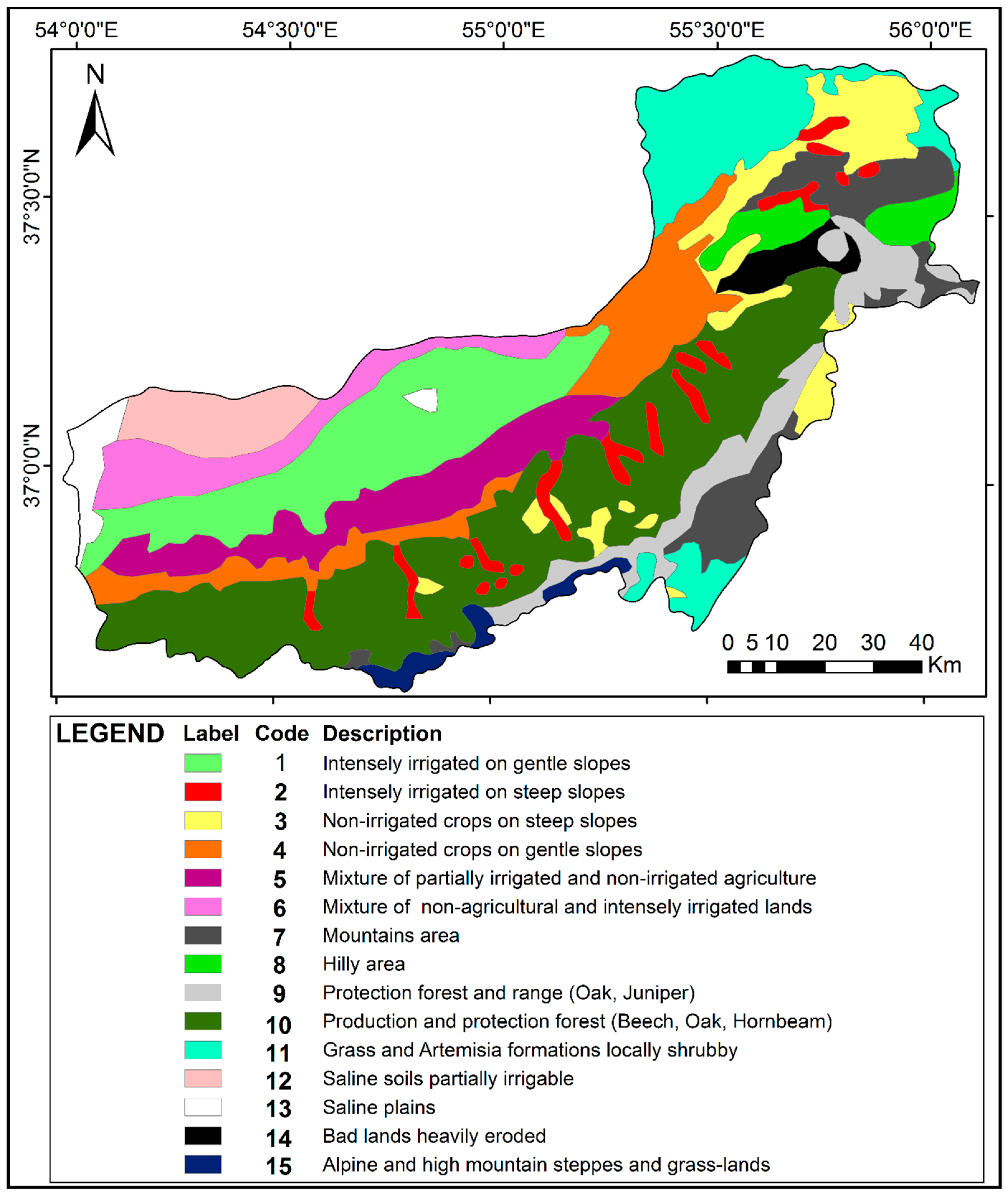
| Landcover (ID) | 1 | 12.90 | 2 | 0.58 | 0.040 | 0.107 |
| 2 | 3.12 | 52 | 15.11 | 4.840 | 0.900 | |
| 3 | 6.69 | 93 | 27.03 | 4.040 | 0.768 | |
| 4 | 8.45 | 9 | 2.61 | 0.300 | 0.150 | |
| 5 | 7.48 | 6 | 1.74 | 0.230 | 0.138 | |
| 6 | 5.16 | 3 | 0.87 | 0.170 | 0.128 | |
| 7 | 6.22 | 2 | 0.58 | 0.090 | 0.115 | |
| 8 | 2.62 | 4 | 1.16 | 0.440 | 0.173 | |
| 9 | 5.73 | 12 | 3.49 | 0.600 | 0.199 | |
| 10 | 24.16 | 147 | 42.73 | 1.770 | 0.393 | |
| 11 | 9.20 | 13 | 3.78 | 0.410 | 0.168 | |
| 12 | 3.74 | 0 | 0.00 | 0.000 | 0.100 | |
| 13 | 1.71 | 0 | 0.00 | 0.000 | 0.100 | |
| 14 | 1.52 | 1 | 0.29 | 0.190 | 0.131 | |
| 15 | 1.25 | 0 | 0.00 | 0.000 | 0.100 | |
| Distance to roads (m) | 0–100 | 4.51 | 72 | 20.93 | 4.640 | 0.900 |
| 100–200 | 3.76 | 38 | 11.04 | 2.930 | 0.568 | |
| 200–300 | 4.06 | 30 | 8.72 | 2.140 | 0.415 | |
| 300–400 | 3.40 | 29 | 8.43 | 2.470 | 0.479 | |
| 400–500 | 3.58 | 31 | 9.01 | 2.510 | 0.486 | |
| 500< | 80.67 | 144 | 41.86 | 0.520 | 0.100 | |
| Distance to rivers network (m) | 0–100 | 5.41 | 83 | 24.12 | 4.450 | 0.900 |
| 100–200 | 4.59 | 45 | 13.08 | 2.850 | 0.549 | |
| 200–400 | 9.38 | 37 | 10.75 | 1.140 | 0.175 | |
| 400–700 | 13.08 | 36 | 10.46 | 0.800 | 0.100 | |
| 700–1000 | 11.74 | 39 | 11.33 | 0.960 | 0.135 | |
| 1000–1500 | 16.85 | 54 | 15.69 | 0.930 | 0.128 | |
| 1500< | 38.93 | 50 | 14.53 | 0.370 | 0.100 | |
| Distance to faults (m) | 0–200 | 9.30 | 61 | 17.73 | 1.900 | 0.900 |
| 200–400 | 7.85 | 43 | 12.50 | 1.590 | 0.738 | |
| 400–600 | 6.81 | 47 | 13.66 | 2.000 | 0.952 | |
| 600–1000 | 10.54 | 55 | 15.10 | 1.510 | 0.696 | |
| 1000< | 65.49 | 138 | 40.11 | 0.610 | 0.225 | |
| Climate (type) | Very humid | 15.32 | 97 | 28.19 | 1.840 | 0.900 |
| Humid | 19.95 | 83 | 24.12 | 1.210 | 0.626 | |
| Semi humid | 13.37 | 25 | 7.26 | 0.540 | 0.335 | |
| Mediterranean | 15.24 | 85 | 24.71 | 1.620 | 0.804 | |
| Semiarid | 35.55 | 54 | 15.69 | 0.440 | 0.291 | |
| Arid | 0.02 | 0 | 0.00 | 0.000 | 0.100 | |
| Annual average rainfall (mm) | 150 | 0.01 | 0 | 0.00 | 0.000 | 0.100 |
| 200 | 0.15 | 0 | 0.00 | 0.000 | 0.100 | |
| 250 | 2.11 | 0 | 0.00 | 0.000 | 0.100 | |
| 300 | 9.73 | 1 | 0.29 | 0.030 | 0.109 | |
| 400 | 20.36 | 31 | 9.01 | 0.440 | 0.225 | |
| 500 | 19.40 | 99 | 28.78 | 1.480 | 0.521 | |
| 600 | 16.48 | 31 | 9.01 | 0.540 | 0.254 | |
| 700 | 13.03 | 41 | 11.92 | 0.910 | 0.359 | |
| 800 | 13.92 | 97 | 28.19 | 2.020 | 0.675 | |
| 900 | 4.13 | 40 | 11.62 | 2.810 | 0.900 | |
| 1000 | 0.64 | 4 | 1.16 | 1.820 | 0.618 | |
| Annual average temperature (°C) | 4 | 0.34 | 0 | 0.00 | 0.000 | 0.100 |
| 6 | 1.42 | 2 | 0.58 | 0.400 | 0.269 | |
| 8 | 2.36 | 3 | 0.87 | 0.370 | 0.257 | |
| 10 | 8.88 | 23 | 6.68 | 0.750 | 0.417 | |
| 12 | 7.14 | 21 | 6.10 | 0.850 | 0.460 | |
| 14 | 34.92 | 227 | 65.99 | 1.890 | 0.900 | |
| 16 | 32.01 | 64 | 18.60 | 0.580 | 0.346 | |
| 18 | 12.90 | 4 | 1.16 | 0.090 | 0.138 |
| γ Value | The Lowest Output Susceptibility | The Highest Output Susceptibility |
|---|---|---|
| 0.5 | 0 | 0.294 |
| 0.6 | 0 | 0.376 |
| 0.7 | 0 | 0.480 |
| 0.8 | 0.003 | 0.613 |
| 0.9 | 0.056 | 0.873 |
| 0.95 | 0.218 | 0.885 |
| 0.975 | 0.429 | 0.940 |
| BPANN Models | Training Accuracy (%) | Test Accuracy (%) | Overall Incorrect Predictions (%) |
|---|---|---|---|
| 1 | 85.7 | 81.8 | 15.08 |
| 2 | 86.4 | 84.3 | 14.02 |
| 3 | 84.9 | 85.5 | 14.98 |
| 4 | 87.7 | 84.8 | 12.88 |
| 5 | 80.7 | 82.1 | 19.02 |
| 6 | 85.9 | 80.9 | 15.01 |
| 7 | 87.9 | 83.3 | 13.02 |
| 8 | 91.4 | 88.0 | 9.28 |
| 9 | 82.6 | 85.1 | 16.09 |
| 10 | 87.2 | 80.7 | 14.10 |
| Susceptibility Zone | Zones Area % | Landslides % | ||||
|---|---|---|---|---|---|---|
| FG | BLR | C5DT | SVM | BPANN | ||
| Very low | 20 | 1.62 | 0.93 | 0.70 | 0.93 | 1.39 |
| Low | 20 | 1.39 | 1.39 | 1.86 | 1.86 | 0.93 |
| Medium | 20 | 6.26 | 3.94 | 3.25 | 2.78 | 1.16 |
| High | 20 | 14.85 | 11.60 | 11.37 | 13.46 | 9.51 |
| Very high | 20 | 75.87 | 82.13 | 82.83 | 80.97 | 87.01 |
© 2019 by the authors. Licensee MDPI, Basel, Switzerland. This article is an open access article distributed under the terms and conditions of the Creative Commons Attribution (CC BY) license (http://creativecommons.org/licenses/by/4.0/).
Share and Cite
Vakhshoori, V.; Pourghasemi, H.R.; Zare, M.; Blaschke, T. Landslide Susceptibility Mapping Using GIS-Based Data Mining Algorithms. Water 2019, 11, 2292. https://doi.org/10.3390/w11112292
Vakhshoori V, Pourghasemi HR, Zare M, Blaschke T. Landslide Susceptibility Mapping Using GIS-Based Data Mining Algorithms. Water. 2019; 11(11):2292. https://doi.org/10.3390/w11112292
Chicago/Turabian StyleVakhshoori, Vali, Hamid Reza Pourghasemi, Mohammad Zare, and Thomas Blaschke. 2019. "Landslide Susceptibility Mapping Using GIS-Based Data Mining Algorithms" Water 11, no. 11: 2292. https://doi.org/10.3390/w11112292