1. Introduction
Agricultural water and land resources are important agricultural production resources. The quantity and utilization of water resources directly affect the production capacity of cultivated land resources, and the reclamation degree of cultivated land resources also restricts the development and utilization of water resources [
1,
2]. Therefore, the matching degree of agricultural water and land resources is related to the level of regional agricultural development [
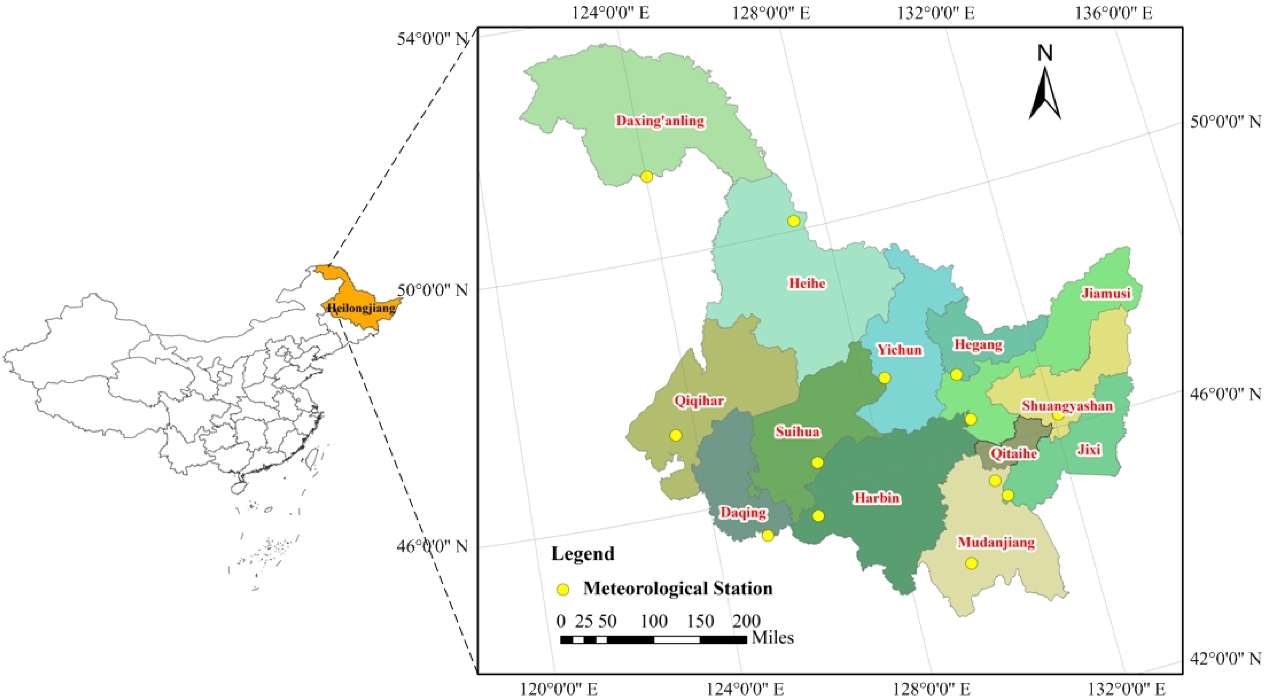
3]. Northeast black soil area in China is one of the three black soil zones in the world. Heilongjiang Province has nearly 12.08 million hm
2 of black soil farmland, accounting for about 44% of the total area of northeast black soil area [
4]. Due to excessive reclamation and predatory management, as well as unreasonable farming and fertilization, farmland soil has been degraded year by year, the black soil layer has become thinner and soil quality has decreased, which seriously restricts the food production. Therefore, analyzing the temporal and spatial matching degree of agricultural water and land resources in Heilongjiang Province has scientific guiding significance for the rational development and utilization of water resources and cultivated land resources, and it is also the foundation of the spatial optimal allocation of water and land resources.
At present, water and land resources matching is mainly estimated by the Gini coefficient method [
5] and the amount of water resources per unit area of cultivated land [
6,
7]. Although the matching of water and land resources can be studied from the overall macro scale, the effects of climate and regional planting structure changes on the utilization of water and land resources are not fully considered, so it is difficult to reflect the temporal and spatial changes of the potential of regional agricultural water and land resources. Hoekstra put forward the concept of water footprint, which is used to measure the total amount of water needed for product production in a country or region in a certain period of time, and total water footprint is the sum of the blue water, green water and gray water footprints [
8]. The gray water footprint refers to the amount of water resources diluted by pollutants in the process of crop growth. Studies show that about 90% of the water footprint of human consumption comes from agricultural products [
9]. Agricultural pollution has replaced industrial pollution as the largest source of pollution in China. China’s agricultural water consumption has long accounted for more than 1/2 of the country’s total water supply, and agricultural pollution has aggravated China’s water pollution [
10]. Heilongjiang Province, as the main grain producing area in China, accounts for 89% of agricultural water consumption, and the heavy use of chemical fertilizers and pesticides has polluted agricultural water resource [
11]. In order to alleviate agricultural water pollution, it is necessary to take the gray water footprint as a necessary water consumption in agricultural production, so as to promote the green development of agriculture. Yet, to the authors’ knowledge, the gray water footprint has been less considered in the research on the agricultural water and land resources matching. Therefore, the establishment of agricultural water and land resources matching method from the perspective of total water footprint of crop production can not only fully take into account the impact of crop types and climatic conditions, but also provides a new perspective for the optimal allocation of water and land resources.
In recent years, with the improvement of the water footprint theory on the basis of virtual water theory and the concept of ecological footprint [
12,
13], the water and land resources matching from the perspective of water footprint has gradually become a research hotspot. Liu et al. constructed a refined index for measuring the regional matching characteristics between water and land resources, the results showed introducing the broadly defined agricultural water resources into the established models as the characteristic parameter of water resource quantity is scientific and reasonable [
14]. Cao et al. used the calculation method of generalized agricultural water and land resources matching coefficient to analyze the matching characteristics of water and land resources during the growth period of spring maize in Liaoning Province from 1985 to 2018 based on the perspective of water footprint of crop production, the results showed that the future adjustment of maize planting structure in Liaoning Province should be based on the matching characteristics of agricultural water and land resources in different regions [
15]. Qin used the Gini coefficient and agricultural water and land resources matching model to analyze agricultural water and land resources matching coefficient in broad sense and narrow sense, the results showed the study, in a broad sense, can better reflect the actual matching pattern of agricultural water and land resources [
9]. Fan and Fu discussed the situation of water footprint in the process of crop production in the Yangtze River economic belt of China and calculated the matching degree of agricultural water and land resources on this basis, the results showed that the introduction of virtual water into the matching degree analysis of water and land resources was closer to the actual situation [
16]. Despite research efforts on the agricultural water and land resources matching, few studies have been oriented from a total water footprint (including gray water) footprint perspective, whereas a lack of a total water footprint (including gray water footprint) may lead to a biased view development and utilization of agricultural water and land resources.
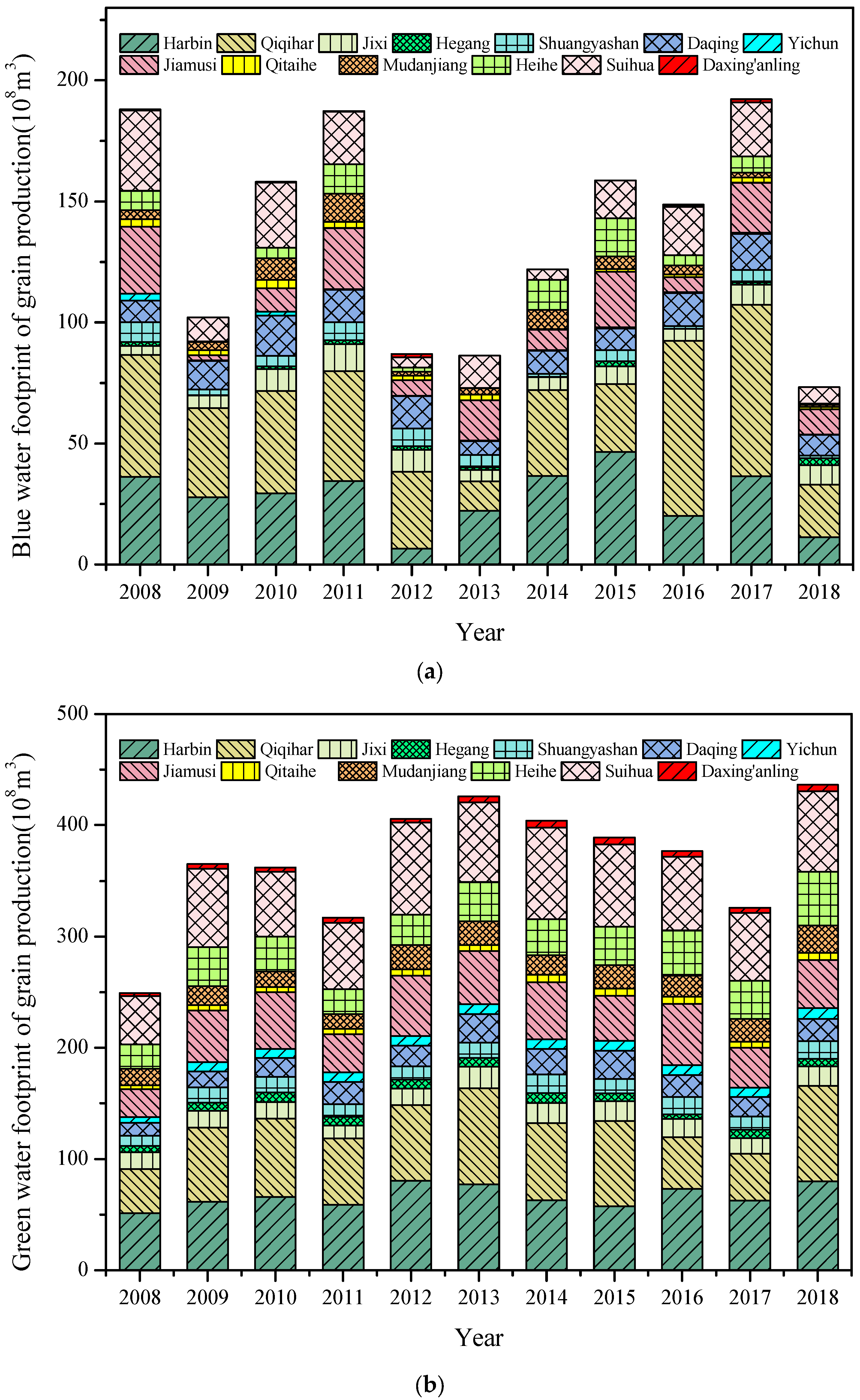
This paper attempts to introduce the gray water footprint as an indispensable part of crop production water consumption into the total water footprint, take the total water footprint as the characterization parameter of water resources, and explore the matching degree of agricultural water and land resources from the perspective of crop production. The objectives of this research are to: (1) calculate the total water footprint as the characterization index of agricultural water resources in Heilongjiang Province; (2) construct the Gini coefficient model to study the matching pattern of water and land resources based on total water footprint and cultivated land area; (3) construct the matching coefficient model of water and land resources to study spatiotemporal matching patterns between water and land resources; and (4) use the equivalent coefficient model to confirm the rationality of improved index. It is expected to more comprehensively characterize the amount of water resources in agricultural production through the total water footprint, in order to provide effective management and policy making for the green development of agriculture.
5. Discussion
Currently, most studies that characterize water resources utilize the total amount of water resources [
26], irrigation water consumption [
29], the available amount of water resources [
30] or the blue–green amount of water [
14]. However, with the development of agriculture, the use of chemical fertilizer is increasing, and the water resources are becoming polluted to some extent. In this study, the gray water footprint was introduced to study the matching of water and land resources. Not only were the agricultural irrigation water and the effective precipitation absorbed by crops considered, but also the freshwater resources used to dilute pollutants and enable the water quality to meet the standard are included in the water resources from the aspect of environmental protection.
In order to analyze whether it is reasonable to use the total water footprint as the characterization parameter of water resources, the equivalent coefficient method based on agricultural water consumption is used to verify it. The methods for calculation are as follows:
where
I is the equivalent coefficient of agricultural water and land resources;
Wa is the agricultural water consumption, m
3;
Lc is the area of cultivated land, hm
2;
Wt is the total amount of regional water resources, m
3, and
Lt is the total land area, km
2.
I > 1 indicates the urgency of water shortage will be higher, and
I < 1 indicates that cultivated land resources are in a state of shortage compared with water resources.
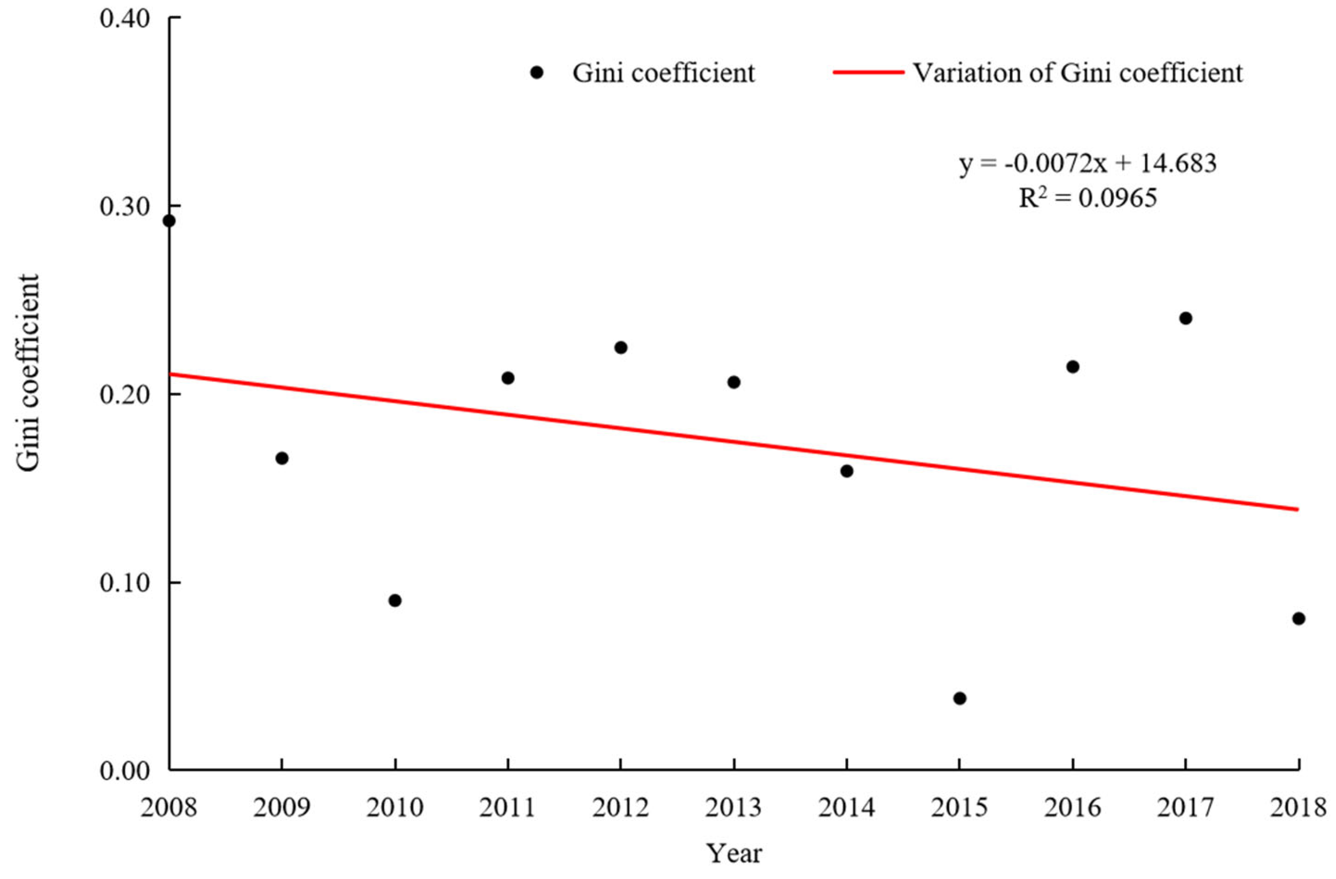
The equivalent coefficient of agricultural water and land resources in Heilongjiang Province is 1.08, close to 1, reflecting the relative balance of agricultural water resources and land resources in Heilongjiang Province. The results of the equivalent coefficient model are basically consistent with those of the Gini coefficient model, indicating that it is scientific and reasonable to use the total water footprint as the characteristic parameter of water resources.
Hou et al. took the proportion of agricultural water consumption to calculate the agricultural water and land resources matching coefficient [
31], the average matching coefficient from 2009 to 2018 in Heilongjiang Province was 3820 m
3/hm
2, and the average matching coefficients in the current study from 2009 to 2018 in Heilongjiang were 3548 m
3/hm
2. The statistics on agricultural water consumption include a portion of losses during water delivery, which cannot accurately reflect the actual water consumption of crop production. The agricultural water and land resources matching method from the perspective of the total water footprint takes into account the impact of crop types and climatic conditions on agricultural water and land resources matching patterns, and can express the actual situation of water consumption in agricultural production more accurately.
It should also be noted that Cao et al. pointed out that calculating total water footprint lacking field observations may be affected by the accuracy of certain parameters and the resulting uncertainty in essential assumptions [
32], and the calculation of gray water footprint focuses on nitrogen loss only and failing to consider other pollution sources and water treatment in the proposed methodology. Therefore, the calculation of total water footprint from reliable measurements can be undertaken if possible. At the same time, measures such as strengthening the construction of water conservancy facilities, restricting and regulating the use of pesticides, and improving the efficiency of water resources should also be adopted.
6. Conclusions
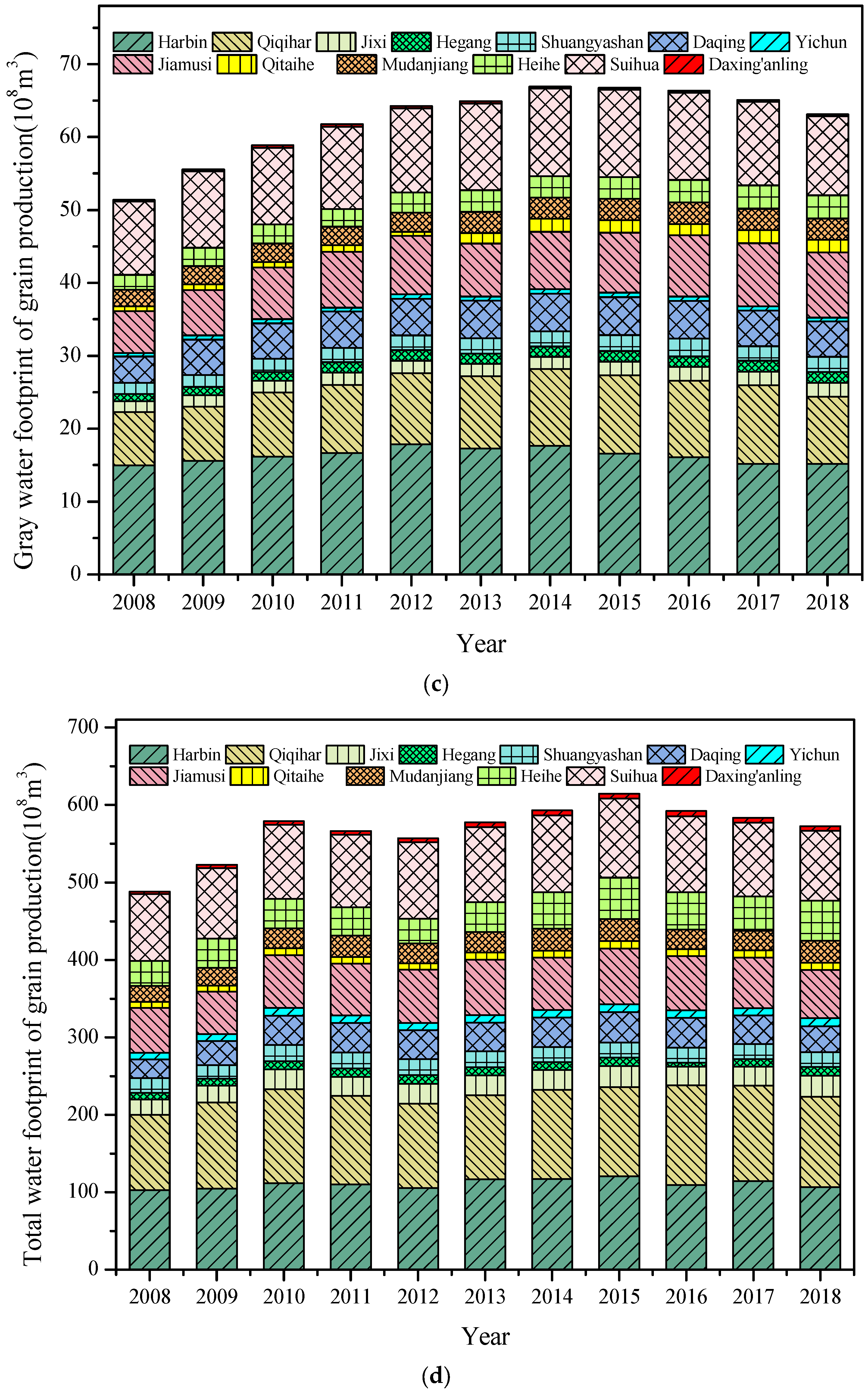
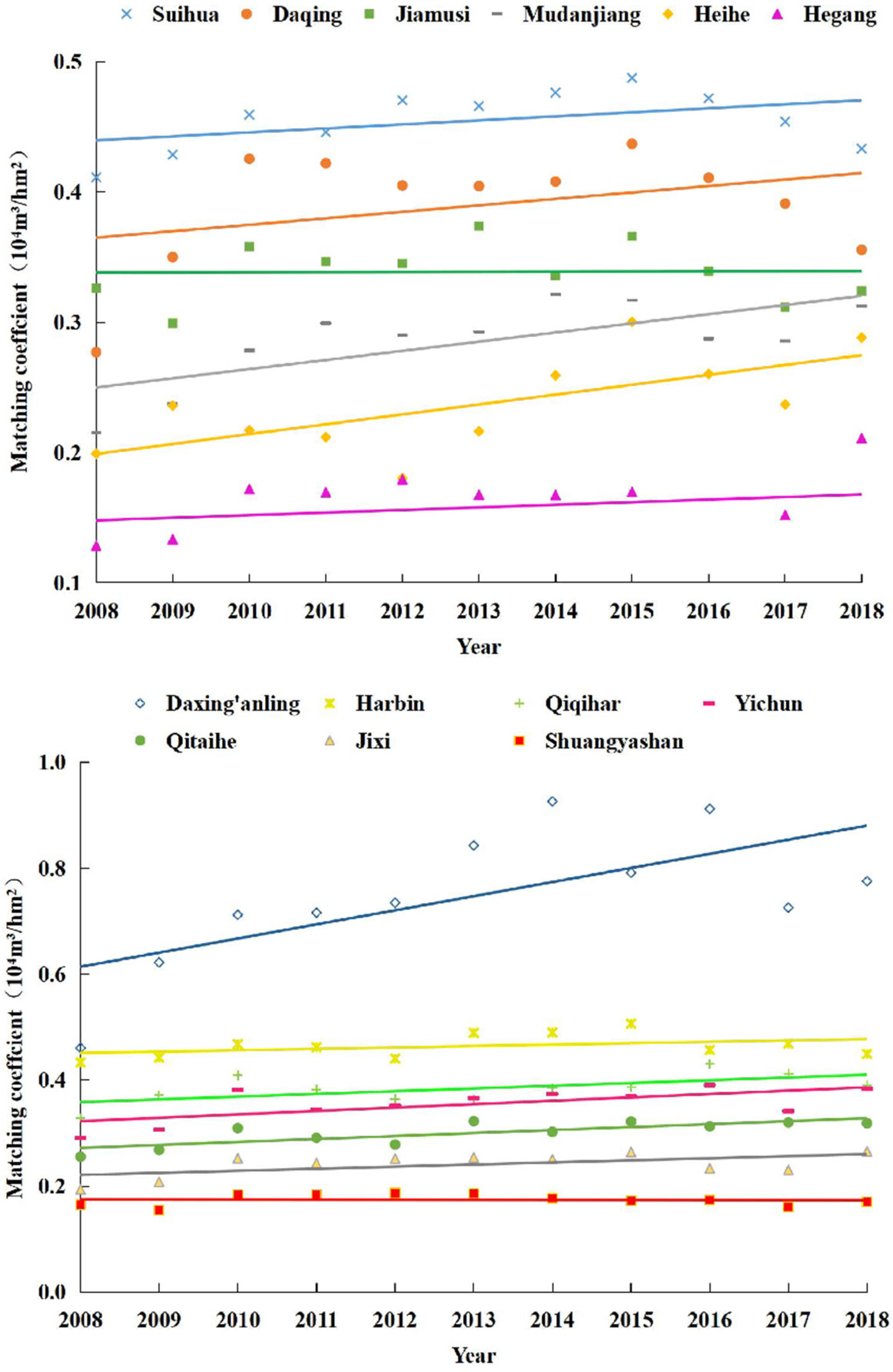
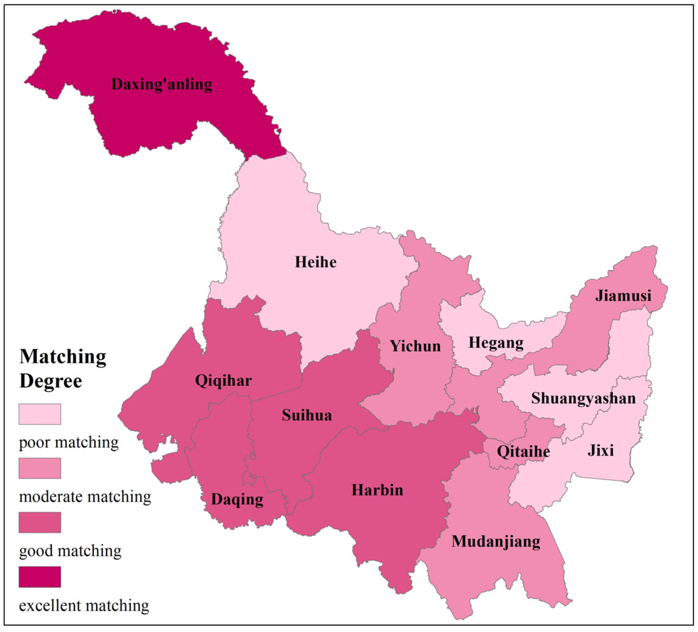
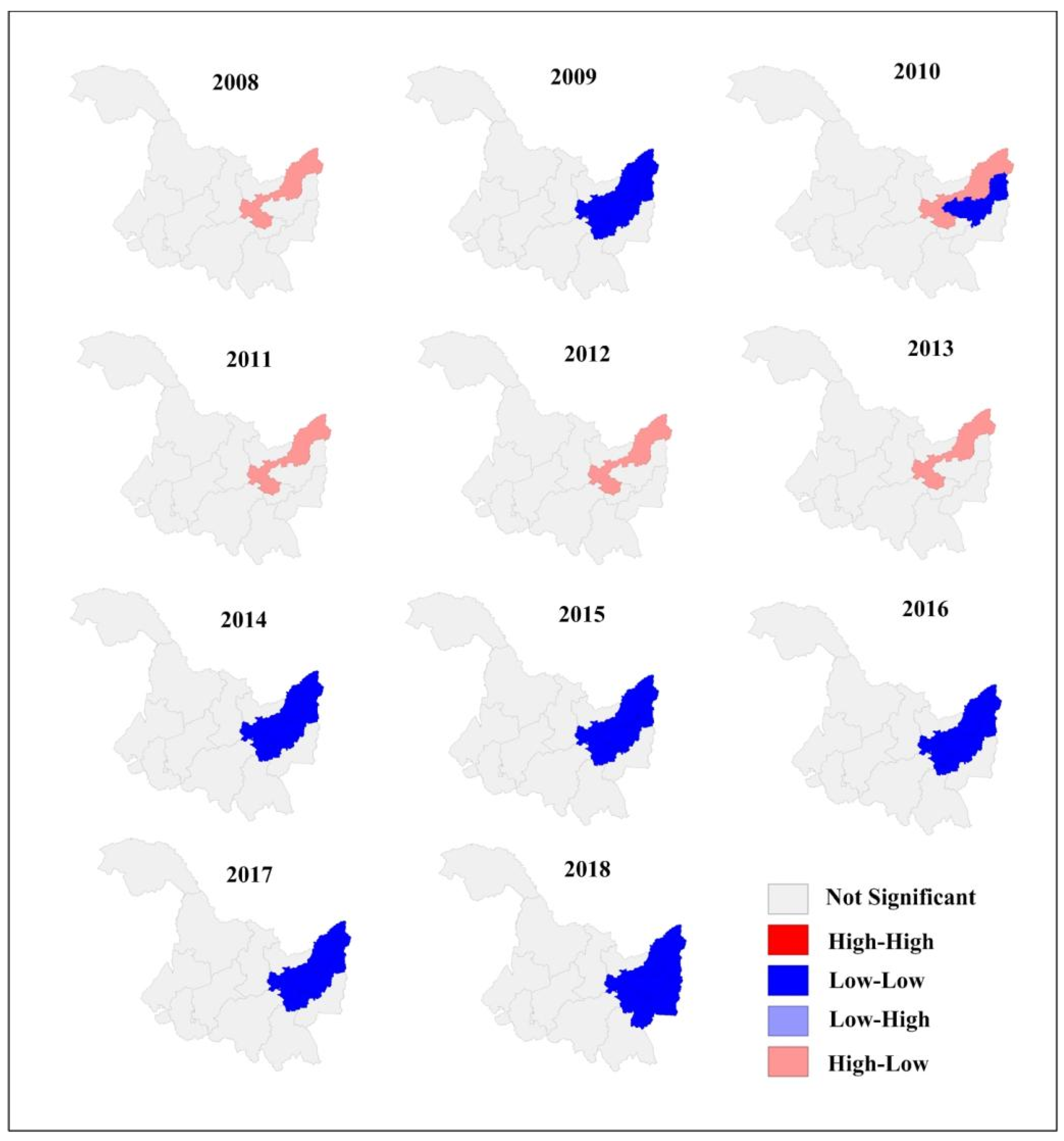
The results of the Gini coefficient model indicated that the agricultural water and land resources in Heilongjiang Province matches well. The matching degree of agricultural water and land resources in different regions of Heilongjiang Province exhibited a fluctuating variation and increased gradually from the northeast to the southwest. Based on Moran’s I index, the matching coefficient of agricultural water and land resources in Heilongjiang Province has significant spatial correlation.
The results of equivalent coefficient model were consistent with the results of the Gini coefficient model, which demonstrated that using the total water footprint as the characteristic parameter of water resources is scientific and reasonable.
In order to reduce the impact of HWT and improve the utilization efficiency of chemical fertilizers, some measures, such as enhancing the farmers’ consciousness of scientific fertilization and accurate application of fertilizer based on planting crops, need to be adopted.


